Major TV networks were notified on Friday that the department was examining whether they violated antitrust laws when they suspended pool coverage of President Trump.
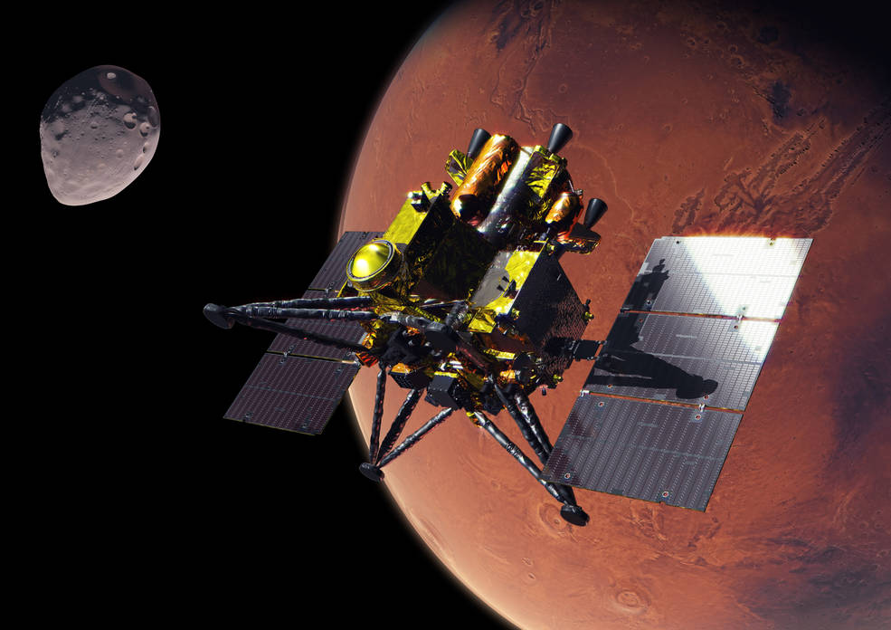
An artist’s concept of JAXA’s (Japan Aerospace Exploration Agency) Martian Moons eXploration (MMX) spacecraft at Mars.
Credit: JAXA
Media are invited to join NASA for a media teleconference at 4 p.m. EDT, Thursday, Oct. 15, to preview the agency’s contributions to JAXA’s (Japan Aerospace Exploration Agency) Martian Moons eXploration (MMX) mission. The mission is scheduled to launch from JAXA’s Tanegashima Space Center in Japan on Monday, Oct. 19 EDT (Tuesday, Oct. 20 JST).
Audio of the media teleconference will stream on the agency’s website at:
Participants in the briefing, who will provide an overview of the mission and NASA’s contributions, include:
Lindsay Hays, acting director, Planetary Science Division, NASA Headquarters in Washington
Tom Statler, MMX program executive and scientist, Planetary Science Division, NASA Headquarters
David Lawrence, MEGANE (Mars-moon Exploration with Gamma-rays and Neutrons) principal investigator, Johns Hopkins Applied Physics Laboratory
Kris Zacny, vice president, Blue Origin’s Honeybee Robotics
Media interested in participating by phone must RSVP no later than two hours prior to the start of the teleconference to Molly Wasser at molly.l.wasser@nasa.gov. A copy of NASA’s media accreditation policy is online.
The MMX spacecraft will arrive at Mars in August 2027 to begin its survey of the Red Planet’s two moons, Phobos and Deimos. After surveying Phobos in detail, the spacecraft will collect a sample of the moon’s surface no earlier than December 2028 and deliver it to Earth in 2031. NASA’s contributions to the mission include the MEGANE gamma-ray and neutron spectrometer, the spacecraft’s surface sampler mechanism, and communications and navigation support from the agency’s Deep Space Network, as well as funding United States scientists participating on the MMX science team.
The MEGANE instrument was developed by Johns Hopkins Applied Physics Laboratory. Honeybee Robotics, a Blue Origin company, developed the spacecraft’s pneumatic sampler mechanism. NASA’s contributions to the MMX mission were funded by the agency’s Discovery Program, which provides frequent flight opportunities for high-value, focused planetary science investigations. The Discovery Program is managed by NASA’s Marshall Space Flight Center in Huntsville, Alabama, for the agency’s Science Mission Directorate in Washington.
For more information about the MMX mission, visit:
A discussion of smart TV privacy examines reports of LG televisions collecting viewing data, whether TVs should ever be connected to the internet, and when firmware updates are worthwhile. The MacVoices Live! panel also considers hotel TV privacy, Microsoft’s increasingly pervasive Copilot strategy and organizational changes, and the enduring influence of Star Trek technology on real-world innovation.
Widow’s Bay has turned its first season into one of the most decorated comedy debuts in Emmy history, collecting 14 awards at the 78th Primetime Emmy Awards and giving Apple TV its biggest awards performance for a single series this year.
The comedy-horror series won Outstanding Comedy Series alongside major acting, writing, directing, casting, cinematography, music, production design, and sound honors. Its 14 victories also set a record for the most Emmy wins by a comedy series in a single season, surpassing the benchmark established by The Studio a year earlier.
The sweep came after Widow’s Bay entered the awards cycle with 19 nominations. Apple finished the 2026 Emmys with 29 awards overall, with Widow’s Bay accounting for nearly half of the total.
Image Credit: Apple Inc.
Widow’s Bay dominates the major Emmy categories
Matthew Rhys won Outstanding Lead Actor in a Comedy Series for his performance as Mayor Tom Loftis, the well-intentioned but frequently overwhelmed leader of a remote New England island community.
Kate O’Flynn won Outstanding Supporting Actress in a Comedy Series, while Stephen Root took Outstanding Supporting Actor. Betty Gilpin had already secured Outstanding Guest Actress during the Creative Arts Emmys.
Creator Katie Dippold won Outstanding Writing for a Comedy Series for the premiere episode, while Hiro Murai received Outstanding Directing for a Comedy Series. The Television Academy also recognized Murai as the first Asian director to win the comedy directing category.
Those awards gave the show victories across nearly every major creative discipline involved in building the series. Widow’s Bay also received Emmys for production design, casting, cinematography, original dramatic score, music supervision, sound editing, and sound mixing.
The breadth of the wins is notable because the show was not carried solely by one high-profile performance or writing prize. Acting, directing, writing, visual design, music, and technical execution all received separate recognition.
Apple says Widow’s Bay also earned more performance awards than any other series at the 2026 Emmys.
Widow’s Bay found a distinctive balance between horror and comedy
Created by Dippold, Widow’s Bay follows Tom Loftis as he tries to transform an isolated island town into a viable tourist destination despite warnings from residents that the community is cursed.
The premise initially plays on civic frustration and small-town politics. The island has unreliable connectivity, a skeptical population, and a mayor determined to prove that local superstition is holding economic development back. As visitors begin to arrive, the supernatural stories that Loftis has dismissed start becoming harder to explain away.
That structure allows the series to operate as both a character comedy and a genuine horror story rather than treating supernatural events simply as setups for jokes.
Dippold, whose earlier work includes The Heat and Ghostbusters, serves as creator, showrunner, writer, and executive producer. Murai, known for visually distinctive television work including Atlanta, directs and executive produces.
The executive-producing team also includes Carver Karaszewski, Claudia Shin, and Rhys.
Apple and Television Academy records list Apple Studios and Chum Films among the production companies behind the series. The directing roster extends beyond Murai to Ti West, Sam Donovan, and Andrew DeYoung.
The main cast includes Rhys, O’Flynn, Root, Kingston Rumi Southwick, Kevin Carroll, and Dale Dickey.
Image Credit: Apple Inc.
A debut season becomes an awards benchmark
Widow’s Bay premiered globally on Apple TV on April 29, 2026. The first two episodes were released together before the remaining episodes arrived weekly.
Its Emmy performance places the series alongside a growing run of Apple comedies that have performed strongly with Television Academy voters.
Ted Lasso previously won Outstanding Comedy Series, followed by The Studio in 2025. Widow’s Bay gives Apple consecutive wins in the category and its fourth Outstanding Comedy Series victory across the past six Emmy ceremonies.
Apple also became the most awarded network at the 2026 Emmys with 29 wins. Pluribus contributed six, including awards for Rhea Seehorn and creator Vince Gilligan, while Margo’s Got Money Troubles and Palm Royale each received three.
Slow Horses won for directing, and Mr. Scorsese received Outstanding Documentary or Nonfiction Series.
For Widow’s Bay itself, the 14-win total is especially significant because this is the show’s freshman season. The Television Academy confirmed six of those awards during the main September 14 telecast, while eight had already been announced during the Creative Arts ceremonies.
The combination took Widow’s Bay beyond The Studio’s previous record for a debut comedy and established a new single-season high for the category.
Matthew Rhys adds another unusual Emmy milestone
Rhys had an especially unusual night beyond his Widow’s Bay victory.
In addition to winning Lead Actor in a Comedy Series, he received another lead-actor Emmy for Netflix’s The Beast in Me in the limited or anthology series or movie category, making him the first performer to win two lead acting awards in different categories during the same Emmy year.
His Widow’s Bay performance is deliberately restrained compared with the increasingly strange circumstances surrounding Loftis. Rather than treating the island’s supernatural events as an invitation to broaden the comedy, Rhys largely plays the mayor as someone trying to maintain a rational civic response while the situation deteriorates.
That tonal approach runs through the rest of the production. Root and O’Flynn’s supporting performances received individual recognition, while Murai’s directing and Dippold’s writing awards reinforced how closely the series depends on maintaining tension without losing its comic rhythm.
All 10 episodes of the first season are currently available to stream on Apple TV. With the Emmy campaign complete, the show now carries a benchmark that future comedy debuts will be measured against: 14 awards from 19 nominations, capped by Outstanding Comedy Series and wins across nearly every part of the production.
A zoomed-in view of the Moon made from images from NASA’s Lunar Reconnaissance Orbiter Camera. (More information at the bottom of article.)
Credits: NASA Goddard/Intuitive Machines/Robert Wagner
It started as a routine data-quality check. But as Robert Wagner, a scientist with NASA’s Lunar Reconnaissance Orbiter (LRO), scanned a giant Moon map on his computer screen, an unusually large bright spot circled by a dark halo caught his eye, as it implied that surface material in that area had been shaken up.
“I just stopped, dropped everything, and started looking into what that spot was,” said Wagner, an image-processing specialist from Intuitive Machines who works with data from the Lunar Reconnaissance Orbiter Camera (LROC) system.
By comparing before and after images of the Moon, Wagner realized he had discovered the largest, newly formed crater ever found in the solar system, as scientists reported Wednesday in Science Advances. This discovery highlights the value of NASA’s Moon orbiter data in studying a dynamic landscape as the agency advances a sustained human presence and expanded scientific and commercial activity on the Moon.
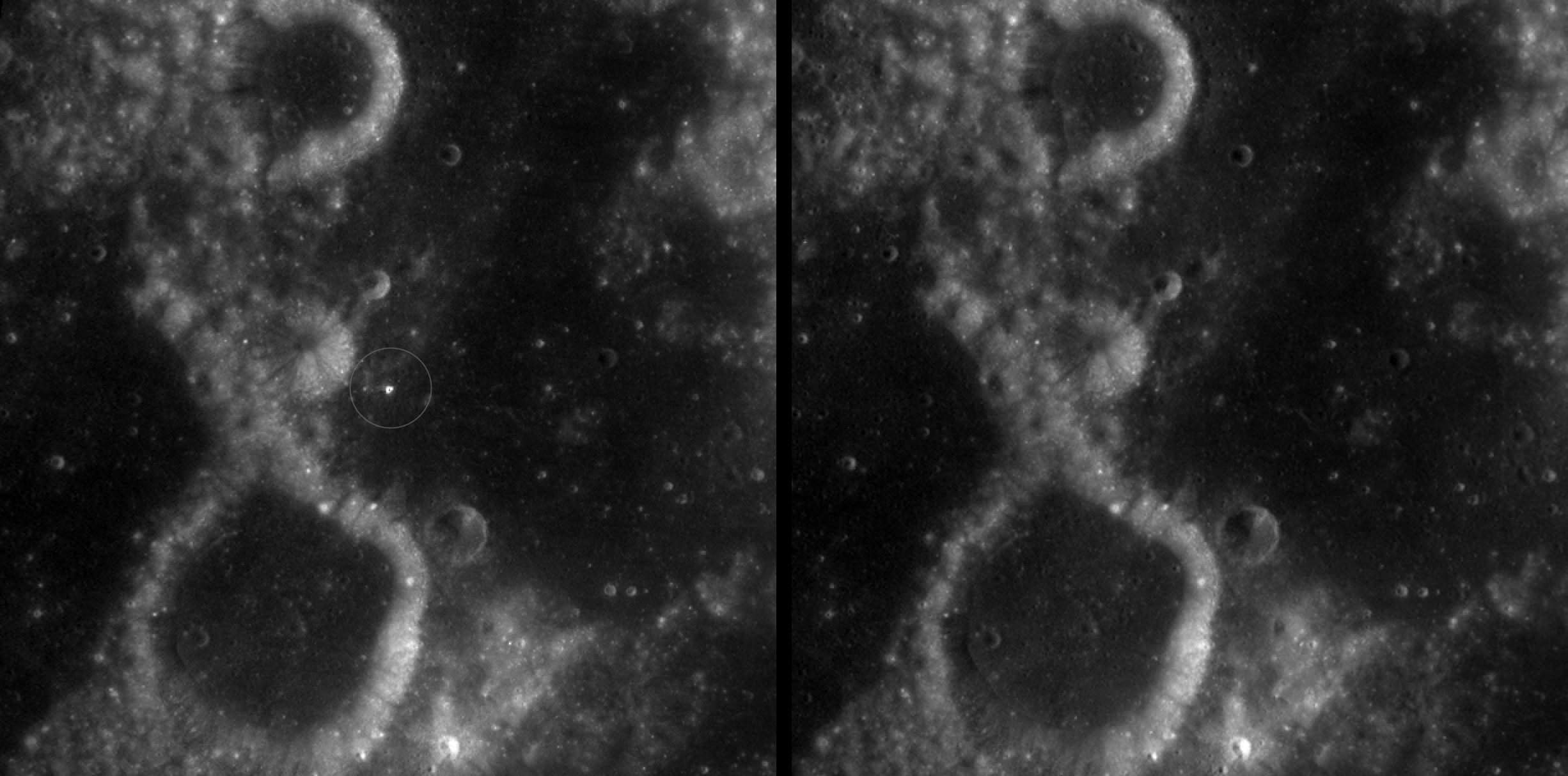
A zoomed-in view of McGetchin crater, circled on the left, next to a “before” image on the right. The panel on the left is made from images captured by NASA’s Lunar Reconnaissance Orbiter Wide-Angle Camera in summer 2025; the right panel was made from images taken in spring 2011. The white spot is not the crater itself, but rather material flung out of the crater, which formed when a rock, possibly this size of a three- to six‑story building, crashed into the Moon between April 11 and May 22, 2024 – a once-in-a-century event, as scientists reported on Sept. 15, 2026, in a pair of papers in Science Advances. The area shown in the images is 38 miles wide.
NASA Goddard/Intuitive Machines/Robert Wagner
Officially named McGetchin after pioneering lunar scientist Tom McGetchin, the crater formed on the Moon’s eastern edge sometime between April 11 and May 22, 2024, after a comet or asteroid the size of a three- to six-story building hit the surface.
The crash left a crater, 728 feet wide, that spans the length of two football fields. And at 141 feet deep, the crater could fit three vertically stacked yellow school buses.
Scientists estimate that an impact of this magnitude happens on the Moon about once in a century or even longer.
Moon takes some hits
For more than 17 years, LRO has been circling the Moon and using its seven instruments to map the topography, surface composition, temperature, and radiation environment there. The spacecraft’s team has identified at least 1,000 new impact craters throughout the mission and flagged 100,000 more surface changes from an object smashing into the Moon or from the debris that flung out after.
With no atmosphere to slow them or burn them up, space rocks and other objects easily reach the lunar surface. Most are much smaller compared to the object that carved out McGetchin crater. The smallest craters scientists can distinguish from LRO images are about 30 feet wide, the length of a three-story building laid on its side, made by rocks about 43 inches wide, the size of a monster-truck tire. Scientists estimate that impacts of this scale produce about 140 new craters across the Moon each year. But most new ones are made by microscopic projectiles that leave holes too small to identify in orbital images.
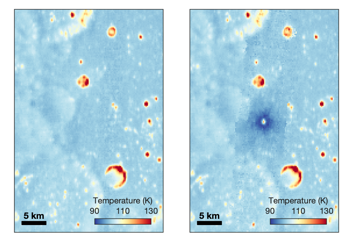
With its numerous instruments, the spacecraft can observe changes to the lunar surface that aren’t apparent in the LROC images alone. After the crater was discovered, scientists working with LRO’s thermal instrument, Diviner, made follow-up observations of the site. They found a 4-mile-wide area around the crater that is about 16 degrees Fahrenheit cooler at night than its surroundings.
This animated image set shows an area on the eastern limb of the Moon before and after McGetchin crater formed there sometime between April 11 and May 22, 2024. The post-impact image was constructed using data taken by NASA’s Lunar Reconnaissance Orbiter (LRO) thermal instrument, Diviner, between Nov. 15, 2025, and Feb. 18, 2026, after scientists discovered the crater in visible-light images taken by LRO’s Wide-Angle Camera. Pre-impact temperatures are from the Diviner Global High-Resolution Mosaics (GHRM). The crater formed on the Moon after a comet or asteroid, possibly the size of a six-story building, hit the surface in a rare, once-in-a-century collision. The dark blue strip that flashes into view reveals a 4-mile-wide “cold spot” around the crater that is about 16 degrees Fahrenheit cooler at night than its surroundings. This cooling happens because an impact fluffs up regolith around a crater, making it less dense and therefore less able to retain heat. Scientists on the Diviner team reported this finding in a paper published on Sept. 16, 2026, in Science Advances. The red and yellow spots indicate areas typically associated with rocks excavated by long-ago impacts which, though still at cryogenic temperatures like their surroundings, remain slightly warmer at night.
NASA Goddard/UCLA/JHU APL
Reporting in a second paper Wednesday in the same journal, researchers say that the cooling happens because the impact fluffs up the regolith around the crater, making it less dense and therefore less able to retain heat.
The large extent of this “cold spot” is striking, scientists say, because it shows that impacts can modify the Moon’s surface far beyond the crater itself. These physical changes could affect how rover wheels interact with the surface, for instance.
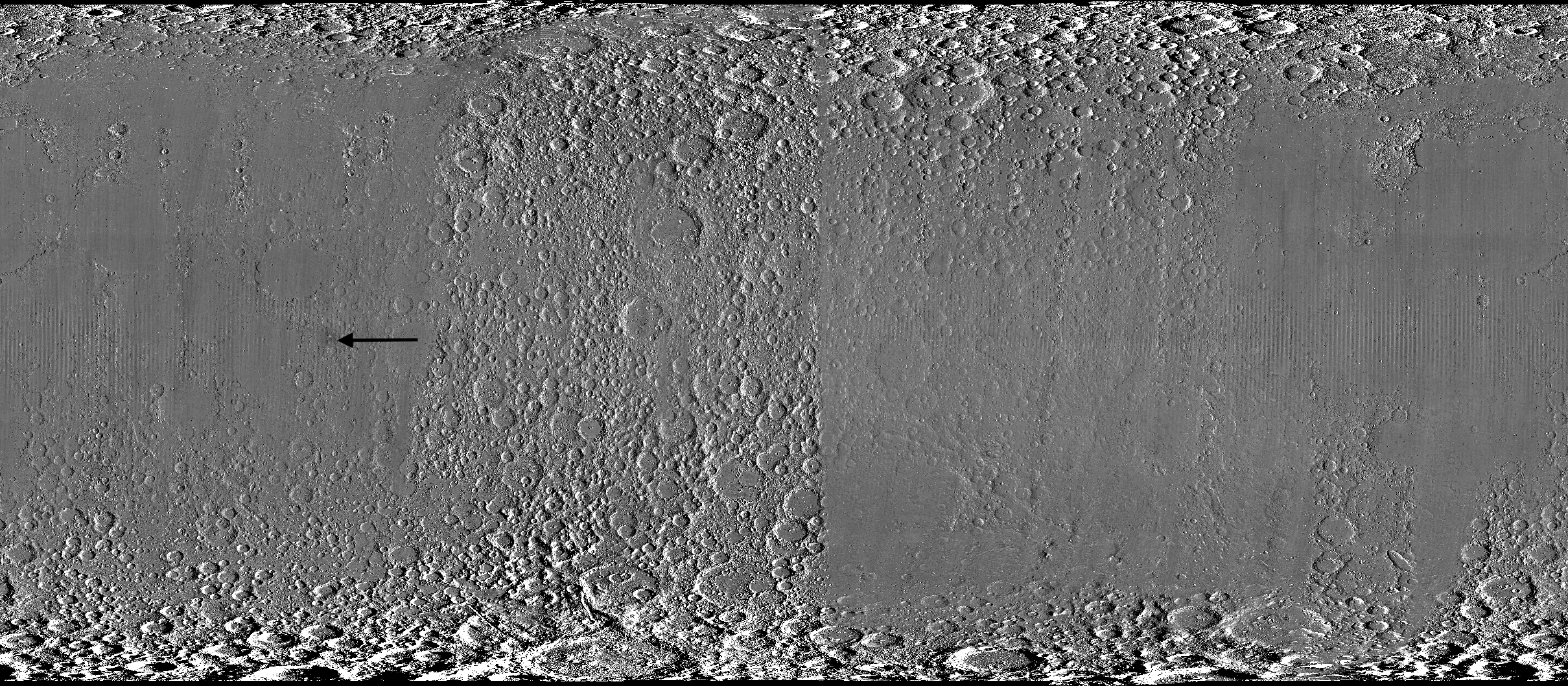
A global view of the Moon made by stitching together hundreds of images from the Wide-Angle Camera aboard NASA’s Lunar Reconnaissance Orbiter (LRO). Robert Wagner, image processing specialist for LRO, made this map using two sets of mages taken several years apart. He used a software designed to highlight any changes between the two sets. Anything that stayed the same turned gray; anything different showed up as bright or dark patches. A black arrow just left of center points to McGetchin crater.
NASA Goddard/Intuitive Machines/Robert Wagner
Road to discovery
The LROC system collects images from about 60 miles above the Moon as LRO loops from pole to pole. The system includes two cameras that capture high‑resolution black‑and‑white images and one camera for moderate‑resolution multispectral images. Over the years and thousands of passes, scientists have built maps detailed enough to spot not only new craters, but also landslides, landers, seismic faults, and even hints of lava tubes.
LROC scientists regularly analyze close-up images of small portions of the Moon’s surface taken by the Narrow-Angle Camera. Using these images, they look for changes that are typically less than 30 feet across. But every few years the team searches for large (wider than 150 feet) features by creating global Moon maps and comparing them to older versions.
An overhead, close-up view of McGetchin crater that was taken on Dec. 5, 2025, by NASA’s Lunar Reconnaissance Orbiter (LRO) Narrow-Angle Camera (NAC). After the crater was discovered on Oct. 24, 2025, in global images from LRO’s Wide-Angle Camera, which captures broad views with pixels the size of American football fields, scientists turned to the NAC, which takes much sharper views at about 3 feet per pixel. The NAC images, taken as LRO flew over the impact site again, revealed the crater size, shape, and how the surrounding terrain was affected by the impact that carved McGetchin. The image covers an area that’s ¾ mile wide.
NASA Goddard/Intuitive Machines
This view from the side (55° away from straight down) towards the east, covers an area of the Moon that’s about 1.5 miles wide. It was taken by NASA’s Lunar Reconnaissance Orbiter Narrow-Angle Camera on March 3, 2026.
NASA Goddard/Intuitive Machines
That’s what Wagner was doing on Oct. 24, 2025, when he came across McGetchin. Using images from LROC’s Wide-Angle Camera, which captures broad views with pixels the size of football fields, he stacked hundreds of “before” and “after” frames with software designed to highlight change. Anything that stayed the same turned gray while anything different showed up as bright or dark patches.
While the process sounds straightforward, spotting real craters requires a lot of manual work. The software flags every tiny shift in lighting or shadow, generating hundreds of false alarms. For this reason, Wagner typically verifies the software, looking for small fuzzy halos around pixel‑wide bright points, which indicate splashes of regolith around a new crater.
Spanning hundreds of pixels, McGetchin stood out immediately. “It was by far the most obvious impact debris pattern I’ve ever seen in one of these images,” Wagner said.
After his discovery, scientists turned to the Narrow-Angle Camera, which takes much sharper views at about 3 feet per pixel. This camera’s close-up images, taken as LRO flew over the impact site again, revealed the crater size, shape, and how the surrounding terrain was affected. These images also helped researchers estimate the size and force of the rock fragment that formed the new crater, details that are expected to appear in a future paper.
Banner image caption: A zoomed-in view of the Moon, with debris around McGetchin crater visible as a white spot circled by a dark halo just right of center of the image (marked with black arrows). This is the view that Robert Wagner saw on Oct. 24, 2025, during a routine data-quality check. Wagner is an image processing specialist for NASA’s Lunar Reconnaissance Orbiter Camera, a system of three cameras. Using images from the Wide-Angle Camera (WAC), which captures broad views with pixels the size of American football fields, he stacked hundreds of images captured by WAC over the last several years with software designed to highlight change. Anything that stayed the same is gray; anything that changed showed up as bright or dark patches. The stripes in the image are due to slight changes in lighting between the older and newer images. This image composite shows an area of the Moon approximately 900 miles across.
About the Author
Lonnie Shekhtman
Senior Science Writer
Shekhtman helps communicate NASA planetary science to the world through news and feature stories on NASA.gov, videos for NASA+ and YouTube, and by working with the media. She reports on lunar and Mars science and exploration; NASA's search for life; missions to Venus, Titan, and Jupiter's Trojan asteroids; and many other topics related to NASA's exploration of our solar system and beyond.
Scientists discovered a crater on the Moon that formed sometime between April 11 and May 22, 2024, after a comet or asteroid the size of a three- to six-story building hit the surface.
The crash left a crater, 728 feet wide, that spans the length of two football fields. And at 141 feet deep, the crater could fit three vertically stacked yellow school buses.
A zoomed-in view of the Moon made from images from NASA’s Lunar Reconnaissance Orbiter Camera. (More information at the bottom of article.)
Credits: NASA Goddard/Intuitive Machines/Robert Wagner
It started as a routine data-quality check. But as Robert Wagner, a scientist with NASA’s Lunar Reconnaissance Orbiter (LRO), scanned a giant Moon map on his computer screen, an unusually large bright spot circled by a dark halo caught his eye, as it implied that surface material in that area had been shaken up.
“I just stopped, dropped everything, and started looking into what that spot was,” said Wagner, an image-processing specialist from Intuitive Machines who works with data from the Lunar Reconnaissance Orbiter Camera (LROC) system.
By comparing before and after images of the Moon, Wagner realized he had discovered the largest, newly formed crater ever found in the solar system, as scientists reported Wednesday in Science Advances. This discovery highlights the value of NASA’s Moon orbiter data in studying a dynamic landscape as the agency advances a sustained human presence and expanded scientific and commercial activity on the Moon.
A zoomed-in view of McGetchin crater, circled on the left, next to a “before” image on the right. The panel on the left is made from images captured by NASA’s Lunar Reconnaissance Orbiter Wide-Angle Camera in summer 2025; the right panel was made from images taken in spring 2011. The white spot is not the crater itself, but rather material flung out of the crater, which formed when a rock, possibly this size of a three- to six‑story building, crashed into the Moon between April 11 and May 22, 2024 – a once-in-a-century event, as scientists reported on Sept. 15, 2026, in a pair of papers in Science Advances. The area shown in the images is 38 miles wide.
NASA Goddard/Intuitive Machines/Robert Wagner
Officially named McGetchin after pioneering lunar scientist Tom McGetchin, the crater formed on the Moon’s eastern edge sometime between April 11 and May 22, 2024, after a comet or asteroid the size of a three- to six-story building hit the surface.
The crash left a crater, 728 feet wide, that spans the length of two football fields. And at 141 feet deep, the crater could fit three vertically stacked yellow school buses.
Scientists estimate that an impact of this magnitude happens on the Moon about once in a century or even longer.
Moon takes some hits
For more than 17 years, LRO has been circling the Moon and using its seven instruments to map the topography, surface composition, temperature, and radiation environment there. The spacecraft’s team has identified at least 1,000 new impact craters throughout the mission and flagged 100,000 more surface changes from an object smashing into the Moon or from the debris that flung out after.
With no atmosphere to slow them or burn them up, space rocks and other objects easily reach the lunar surface. Most are much smaller compared to the object that carved out McGetchin crater. The smallest craters scientists can distinguish from LRO images are about 30 feet wide, the length of a three-story building laid on its side, made by rocks about 43 inches wide, the size of a monster-truck tire. Scientists estimate that impacts of this scale produce about 140 new craters across the Moon each year. But most new ones are made by microscopic projectiles that leave holes too small to identify in orbital images.
With its numerous instruments, the spacecraft can observe changes to the lunar surface that aren’t apparent in the LROC images alone. After the crater was discovered, scientists working with LRO’s thermal instrument, Diviner, made follow-up observations of the site. They found a 4-mile-wide area around the crater that is about 16 degrees Fahrenheit cooler at night than its surroundings.
This animated image set shows an area on the eastern limb of the Moon before and after McGetchin crater formed there sometime between April 11 and May 22, 2024. The post-impact image was constructed using data taken by NASA’s Lunar Reconnaissance Orbiter (LRO) thermal instrument, Diviner, between Nov. 15, 2025, and Feb. 18, 2026, after scientists discovered the crater in visible-light images taken by LRO’s Wide-Angle Camera. Pre-impact temperatures are from the Diviner Global High-Resolution Mosaics (GHRM). The crater formed on the Moon after a comet or asteroid, possibly the size of a six-story building, hit the surface in a rare, once-in-a-century collision. The dark blue strip that flashes into view reveals a 4-mile-wide “cold spot” around the crater that is about 16 degrees Fahrenheit cooler at night than its surroundings. This cooling happens because an impact fluffs up regolith around a crater, making it less dense and therefore less able to retain heat. Scientists on the Diviner team reported this finding in a paper published on Sept. 16, 2026, in Science Advances. The red and yellow spots indicate areas typically associated with rocks excavated by long-ago impacts which, though still at cryogenic temperatures like their surroundings, remain slightly warmer at night.
NASA Goddard/UCLA/JHU APL
Reporting in a second paper Wednesday in the same journal, researchers say that the cooling happens because the impact fluffs up the regolith around the crater, making it less dense and therefore less able to retain heat.
The large extent of this “cold spot” is striking, scientists say, because it shows that impacts can modify the Moon’s surface far beyond the crater itself. These physical changes could affect how rover wheels interact with the surface, for instance.
A global view of the Moon made by stitching together hundreds of images from the Wide-Angle Camera aboard NASA’s Lunar Reconnaissance Orbiter (LRO). Robert Wagner, image processing specialist for LRO, made this map using two sets of mages taken several years apart. He used a software designed to highlight any changes between the two sets. Anything that stayed the same turned gray; anything different showed up as bright or dark patches. A black arrow just left of center points to McGetchin crater.
NASA Goddard/Intuitive Machines/Robert Wagner
Road to discovery
The LROC system collects images from about 60 miles above the Moon as LRO loops from pole to pole. The system includes two cameras that capture high‑resolution black‑and‑white images and one camera for moderate‑resolution multispectral images. Over the years and thousands of passes, scientists have built maps detailed enough to spot not only new craters, but also landslides, landers, seismic faults, and even hints of lava tubes.
LROC scientists regularly analyze close-up images of small portions of the Moon’s surface taken by the Narrow-Angle Camera. Using these images, they look for changes that are typically less than 30 feet across. But every few years the team searches for large (wider than 150 feet) features by creating global Moon maps and comparing them to older versions.
An overhead, close-up view of McGetchin crater that was taken on Dec. 5, 2025, by NASA’s Lunar Reconnaissance Orbiter (LRO) Narrow-Angle Camera (NAC). After the crater was discovered on Oct. 24, 2025, in global images from LRO’s Wide-Angle Camera, which captures broad views with pixels the size of American football fields, scientists turned to the NAC, which takes much sharper views at about 3 feet per pixel. The NAC images, taken as LRO flew over the impact site again, revealed the crater size, shape, and how the surrounding terrain was affected by the impact that carved McGetchin. The image covers an area that’s ¾ mile wide.
NASA Goddard/Intuitive Machines
This view from the side (55° away from straight down) towards the east, covers an area of the Moon that’s about 1.5 miles wide. It was taken by NASA’s Lunar Reconnaissance Orbiter Narrow-Angle Camera on March 3, 2026.
NASA Goddard/Intuitive Machines
That’s what Wagner was doing on Oct. 24, 2025, when he came across McGetchin. Using images from LROC’s Wide-Angle Camera, which captures broad views with pixels the size of football fields, he stacked hundreds of “before” and “after” frames with software designed to highlight change. Anything that stayed the same turned gray while anything different showed up as bright or dark patches.
While the process sounds straightforward, spotting real craters requires a lot of manual work. The software flags every tiny shift in lighting or shadow, generating hundreds of false alarms. For this reason, Wagner typically verifies the software, looking for small fuzzy halos around pixel‑wide bright points, which indicate splashes of regolith around a new crater.
Spanning hundreds of pixels, McGetchin stood out immediately. “It was by far the most obvious impact debris pattern I’ve ever seen in one of these images,” Wagner said.
After his discovery, scientists turned to the Narrow-Angle Camera, which takes much sharper views at about 3 feet per pixel. This camera’s close-up images, taken as LRO flew over the impact site again, revealed the crater size, shape, and how the surrounding terrain was affected. These images also helped researchers estimate the size and force of the rock fragment that formed the new crater, details that are expected to appear in a future paper.
Banner image caption: A zoomed-in view of the Moon, with debris around McGetchin crater visible as a white spot circled by a dark halo just right of center of the image (marked with black arrows). This is the view that Robert Wagner saw on Oct. 24, 2025, during a routine data-quality check. Wagner is an image processing specialist for NASA’s Lunar Reconnaissance Orbiter Camera, a system of three cameras. Using images from the Wide-Angle Camera (WAC), which captures broad views with pixels the size of American football fields, he stacked hundreds of images captured by WAC over the last several years with software designed to highlight change. Anything that stayed the same is gray; anything that changed showed up as bright or dark patches. The stripes in the image are due to slight changes in lighting between the older and newer images. This image composite shows an area of the Moon approximately 900 miles across.
About the Author
Lonnie Shekhtman
Senior Science Writer
Shekhtman helps communicate NASA planetary science to the world through news and feature stories on NASA.gov, videos for NASA+ and YouTube, and by working with the media. She reports on lunar and Mars science and exploration; NASA’s search for life; missions to Venus, Titan, and Jupiter’s Trojan asteroids; and many other topics related to NASA’s exploration of our solar system and beyond.
Scientists discovered a crater on the Moon that formed sometime between April 11 and May 22, 2024, after a comet or asteroid the size of a three- to six-story building hit the surface.
The crash left a crater, 728 feet wide, that spans the length of two football fields. And at 141 feet deep, the crater could fit three vertically stacked yellow school buses.
The European Space Agency is moving "full steam ahead" with development of a robotic mission to Venus after NASA officials determined they were unlikely to fulfill a commitment to provide a US-built radar instrument for the spacecraft, the mission's project scientist said.
The European orbiter, named Envision, will map the Venusian surface at 10 times higher resolution than the last radar mission sent to Venus by NASA in the 1990s. The planet is enshrouded in a blanket of thick clouds of sulfuric acid, rendering its mysterious surface unseen by optical cameras in orbit. Radar is the most effective way to penetrate the clouds of Venus to reveal the terrain below, and scientists will use Envision to look for signs of active volcanism.
NASA and ESA signed a memorandum of understanding in 2024 outlining their partnership on Envision. NASA agreed to supply a US-made synthetic aperture radar instrument, Envision's primary means of mapping the surface of Venus, along with providing tracking and communications support through NASA's Deep Space Network. In exchange, ESA would include US researchers on Envision's science team. Europe would build the Envision spacecraft and the rest of its science instruments and provide the launch on an Ariane 6 rocket.
How 2 US, European Satellites Are Studying Hurricanes During El Niño
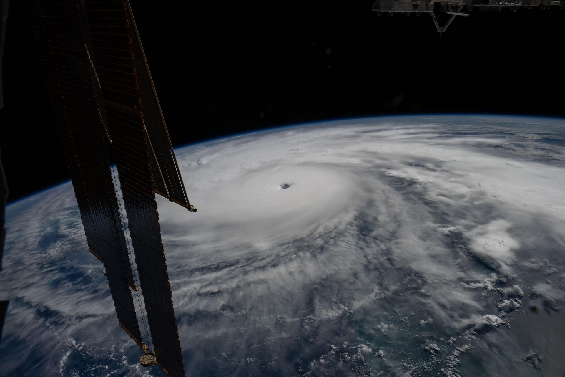
Hurricane Melissa is seen 50 miles south of Jamaica in this photograph taken from the International Space Station on Oct. 28, 2025.
NASA
Last November, NASA and its European partners launched the Sentinel-6B satellite to improve hurricane forecasts, help protect infrastructure, and benefit commercial industries, including shipping. The satellite now is flying 30 seconds behind its predecessor, Sentinel-6 Michael Freilich. Both satellites are providing precise sea level height measurements during what oceanographers expect to be a historic El Niño, a naturally occurring oceanic phenomenon in which warmer-than-usual Pacific waters shift global weather patterns.
The two satellites make up the Copernicus Sentinel-6/Jason-CS (Continuity of Service) mission, the latest in a series of ocean-observing radar altimetry missions that have been monitoring Earth’s changing seas continuously since the early 1990s.
The data each satellite is collecting will not only allow scientists to better understand this year’s El Niño but will also help them create more accurate hurricane predictions.
“This El Niño was a late-bloomer,” said Josh Willis, Sentinel-6B’s project scientist at NASA’s Jet Propulsion Laboratory in Southern California. “It didn’t kick off until the middle of the year and is just now reaching a strength similar to what we’ve seen in the satellite record during significant El Niños in 1997 and 2015. We expect it to be big, and it’s already having big impacts.”
El Niños generally scramble weather patterns tied to rainfall and storms, including hurricanes. They also redistribute heat in the ocean, which affects sea level. Normally, Earth’s warmest ocean waters sit along the equator in the western Pacific. During El Niño, weakened winds, which usually blow westward along the equator, result in heat spreading east toward South America. The change in ocean heat shifts hurricane activity from the Atlantic to the Pacific Ocean.
Predicting hurricane strength
On July 15, Sentinel-6B began delivering low-latency data to scientists that could be used for weather predictions. That data will take some time to work its way into the research models on which meteorologists and climate scientists rely, but when it does, those improved models could save lives.
Data from Sentinel-6 satellite missions feeds into hurricane tracking algorithms used by federal and state agencies. Those predictions can activate disaster response efforts, mobilizing resources ranging from sandbag placement to National Guard activation. They also can lead to evacuation orders that require quick but well-informed decisions about logistics at a local level. More severe events may require engaging larger organizations, such as the Federal Emergency Management Agency.
A tropical storm can take a week or more to become a hurricane and make its way to a coastline, but a hurricane can rapidly intensify in the 48 hours prior to landfall, leaving planners little time to prepare.
“Hurricanes have been known to speed up quickly at the last moment, so the window in which to decide what to do is short,” said Deirdre Byrne, an oceanographer and altimetry expert with the National Oceanic and Atmospheric Administration (NOAA). “The goal is to forecast how much and how rapidly intensification will happen so that officials can make the right calls.”
Each Sentinel-6 satellite measures ocean height, as well as the size of waves and marine wind speed, using a radar altimeter, which bounces thousands of radar pulses a second off the crests and troughs of waves. Ocean height varies from place to place and provides insight into the ocean’s heat content, since warm water expands. That, in turn, helps forecast how fast hurricanes will grow.
Among the measurements Sentinel-6 is gathering, Byrne is most anticipating the ocean height data, which she plans to begin incorporating into the current Satellite Ocean Heat Content Suite algorithm by the end of the year.
“In terms of data quality, the Sentinel-6 missions are unparalleled,” Byrne said.
Together, the missions are also extending a precise dataset deep into its fourth decade. This record of sea level observations traces back to the TOPEX/Poseidon mission, which launched in 1992, and continues through to the present day with Sentinel-6 Michael Freilich. Sentinel-6B will take over for its predecessor as the reference satellite for global sea level measurements later this year.
“The key is consistency, measuring the same way, every time,” said Severine Fournier, Sentinel-6B deputy project scientist, JPL. “That’s what lets us predict hurricanes, and, in turn, protect coastal communities and infrastructure.”
More about Sentinel-6B
Sentinel-6 Michael Freilich, named after a former director of NASA’s Earth Science Division, is one of two satellites that compose the Copernicus Sentinel-6/Jason-CS mission.
Sentinel-6/Jason-CS, a part of the European Union’s Earth observation program called Copernicus, was jointly developed by ESA (European Space Agency), EUMETSAT (European Organisation for the Exploitation of Meteorological Satellites), NASA, and NOAA, with funding support from the European Commission and technical support on performance from the French space agency CNES (Centre National d’Études Spatiales). Spacecraft monitoring and control, as well as the processing of all the altimeter science data, is carried out by EUMETSAT on behalf of the European Union’s Copernicus Programme, with the support of all partner agencies.
NASA JPL, a division of Caltech in Pasadena, contributed three science instruments for each Sentinel-6 satellite: the Advanced Microwave Radiometer, the GNSS-RO, and the Laser Retroreflector Array. NASA also contributed launch services, ground systems supporting operation of the agency’s science instruments, the science data processors for two of these instruments, and support for the United States members of the international Ocean Surface Topography Science Team.
Preparations for Next Moonwalk Simulations Underway (and Underwater)
Hurricane Melissa is seen 50 miles south of Jamaica in this photograph taken from the International Space Station on Oct. 28, 2025.
NASA
Last November, NASA and its European partners launched the Sentinel-6B satellite to improve hurricane forecasts, help protect infrastructure, and benefit commercial industries, including shipping. The satellite now is flying 30 seconds behind its predecessor, Sentinel-6 Michael Freilich. Both satellites are providing precise sea level height measurements during what oceanographers expect to be a historic El Niño, a naturally occurring oceanic phenomenon in which warmer-than-usual Pacific waters shift global weather patterns.
The two satellites make up the Copernicus Sentinel-6/Jason-CS (Continuity of Service) mission, the latest in a series of ocean-observing radar altimetry missions that have been monitoring Earth’s changing seas continuously since the early 1990s.
The data each satellite is collecting will not only allow scientists to better understand this year’s El Niño but will also help them create more accurate hurricane predictions.
“This El Niño was a late-bloomer,” said Josh Willis, Sentinel-6B’s project scientist at NASA’s Jet Propulsion Laboratory in Southern California. “It didn’t kick off until the middle of the year and is just now reaching a strength similar to what we’ve seen in the satellite record during significant El Niños in 1997 and 2015. We expect it to be big, and it’s already having big impacts.”
El Niños generally scramble weather patterns tied to rainfall and storms, including hurricanes. They also redistribute heat in the ocean, which affects sea level. Normally, Earth’s warmest ocean waters sit along the equator in the western Pacific. During El Niño, weakened winds, which usually blow westward along the equator, result in heat spreading east toward South America. The change in ocean heat shifts hurricane activity from the Atlantic to the Pacific Ocean.
Predicting hurricane strength
On July 15, Sentinel-6B began delivering low-latency data to scientists that could be used for weather predictions. That data will take some time to work its way into the research models on which meteorologists and climate scientists rely, but when it does, those improved models could save lives.
Data from Sentinel-6 satellite missions feeds into hurricane tracking algorithms used by federal and state agencies. Those predictions can activate disaster response efforts, mobilizing resources ranging from sandbag placement to National Guard activation. They also can lead to evacuation orders that require quick but well-informed decisions about logistics at a local level. More severe events may require engaging larger organizations, such as the Federal Emergency Management Agency.
A tropical storm can take a week or more to become a hurricane and make its way to a coastline, but a hurricane can rapidly intensify in the 48 hours prior to landfall, leaving planners little time to prepare.
“Hurricanes have been known to speed up quickly at the last moment, so the window in which to decide what to do is short,” said Deirdre Byrne, an oceanographer and altimetry expert with the National Oceanic and Atmospheric Administration (NOAA). “The goal is to forecast how much and how rapidly intensification will happen so that officials can make the right calls.”
Each Sentinel-6 satellite measures ocean height, as well as the size of waves and marine wind speed, using a radar altimeter, which bounces thousands of radar pulses a second off the crests and troughs of waves. Ocean height varies from place to place and provides insight into the ocean’s heat content, since warm water expands. That, in turn, helps forecast how fast hurricanes will grow.
Among the measurements Sentinel-6 is gathering, Byrne is most anticipating the ocean height data, which she plans to begin incorporating into the current Satellite Ocean Heat Content Suite algorithm by the end of the year.
“In terms of data quality, the Sentinel-6 missions are unparalleled,” Byrne said.
Together, the missions are also extending a precise dataset deep into its fourth decade. This record of sea level observations traces back to the TOPEX/Poseidon mission, which launched in 1992, and continues through to the present day with Sentinel-6 Michael Freilich. Sentinel-6B will take over for its predecessor as the reference satellite for global sea level measurements later this year.
“The key is consistency, measuring the same way, every time,” said Severine Fournier, Sentinel-6B deputy project scientist, JPL. “That’s what lets us predict hurricanes, and, in turn, protect coastal communities and infrastructure.”
More about Sentinel-6B
Sentinel-6 Michael Freilich, named after a former director of NASA’s Earth Science Division, is one of two satellites that compose the Copernicus Sentinel-6/Jason-CS mission.
Sentinel-6/Jason-CS, a part of the European Union’s Earth observation program called Copernicus, was jointly developed by ESA (European Space Agency), EUMETSAT (European Organisation for the Exploitation of Meteorological Satellites), NASA, and NOAA, with funding support from the European Commission and technical support on performance from the French space agency CNES (Centre National d’Études Spatiales). Spacecraft monitoring and control, as well as the processing of all the altimeter science data, is carried out by EUMETSAT on behalf of the European Union’s Copernicus Programme, with the support of all partner agencies.
NASA JPL, a division of Caltech in Pasadena, contributed three science instruments for each Sentinel-6 satellite: the Advanced Microwave Radiometer, the GNSS-RO, and the Laser Retroreflector Array. NASA also contributed launch services, ground systems supporting operation of the agency’s science instruments, the science data processors for two of these instruments, and support for the United States members of the international Ocean Surface Topography Science Team.
Dr. Delia Santiago-Materese wants things to get complex
From terrestrial animals to experiments in microgravity and Martian clouds, this NASA program scientist’s career path links diverse challenges. Today, she supports a mission to Saturn’s moon Titan, a world teeming with organic molecules that could hold valuable clues about the origin of life.
When novelty is your hobby, you already have a large part of the recipe for a career full of challenges. That is why Dr. Delia Santiago-Materese describes her path within NASA as “meandering.” Her diverse roles have taken her to low Earth orbit, to the clouds of Mars, and to the surroundings of Jupiter. Now, they are also bringing her closer to the surface of Titan, an intriguing moon of Saturn. Woven together by her exploring spirit and a perennial curiosity, all these experiences have one point in common: life.
Today, Santiago-Materese is part of the Planetary Science Division at NASA Headquarters in Washington. The main decoration in her office is a model of Jupiter, larger than a basketball, resting next to a scale model of the spacecraft exploring it, Juno. Small black and red pins with the inscription “Dragonfly” rest in the center of a round table. Several framed diplomas cover a wall. From here, Santiago-Materese does “a little bit of everything” on any given workday as a program scientist for the Juno and Dragonfly missions, and for the Discovery program, which features a portfolio of several missions in our cosmic neighborhood.
This medley of roles is no coincidence. Santiago-Materese describes herself as someone who does not pursue a single goal, but rather diverse interests that she discovers along the way. “I am always looking for something new to add to my experiences,” she says, “because I think I also get bored easily.”
Santiago-Materese holds her model of Jupiter, just outside her office. As a program scientist for Juno—a mission studying this planet—for Dragonfly, and for the Discovery program, she guides these projects by promoting leadership based on kindness and respect: “Every person brings something unique.”
NASA/Noelia González
The daughter of a military family, Santiago-Materese was born in Spain by coincidence. Her roots are actually on another continent: her mother is Mexican-American and her father is Puerto Rican. From her time in Spain, she only keeps some baby photos; she lived part of her life in Texas and then in California, which she considers her home—despite having spent her childhood summers in San Sebastián, Puerto Rico. It was in the Golden State where she first imagined herself as a veterinarian and decided to study Biological Sciences. And it was during her studies at Stanford University, “just around the corner” from NASA’s Ames Research Center in California’s Silicon Valley, that Santiago-Materese discovered astrobiology.
This elective course brought her closer to a discipline that, to some extent, was in its infancy. Today, NASA’s Astrobiology Program investigates life in the universe on many levels: how it began, how it evolved here on Earth, and where it might exist elsewhere. And that was how Santiago-Materese realized that biology and space were not two isolated things, she recounts.
Rodents, Insects, and Martian Clouds
After finishing her studies, Santiago-Materese completed a one-year internship at the San Francisco Zoo. But the unknown that astrobiology presents continued to intrigue her, so she went back to one of her professors to inquire more about it. She asked around and found someone at Lockheed Martin, a company that often contracts with NASA on space projects. They were looking for people for a new project studying the nutrition of the food bars for rodents traveling to space aboard the space shuttle.
Santiago-Materese has applied that formula ever since: identifying what truly interests her and finding the right person to ask questions. If people “don’t know what you’re interested in, they can’t help you,” she explains. After experience with the Space Shuttle Program, including managing databases for science payloads aboard the space shuttle, she went on to work with the International Space Station, which was then beginning its legacy of over 25 years in Earth orbit. She supported the development of biological experiments in microgravity, this time with fruit flies. But Santiago-Materese wanted to keep moving farther from Earth and investigate future space destinations.
This curiosity led her to the Martian sky. As part of her graduate studies at the University of California, Santa Cruz, Santiago-Materese investigated the Martian atmosphere, focusing on ice in the clouds and the development of climate models for the Red Planet. She earned her master’s degree and would later return to complete her doctorate under the NASA Pathways program, which is one of the agency’s primary early-career hiring pathways. She would defend her thesis six months after giving birth to her first daughter (one of the achievements she is most proud of, she says). That is why, although she loves the “weird” planets of the outer solar system, she is “more of a Mars person,” by training.
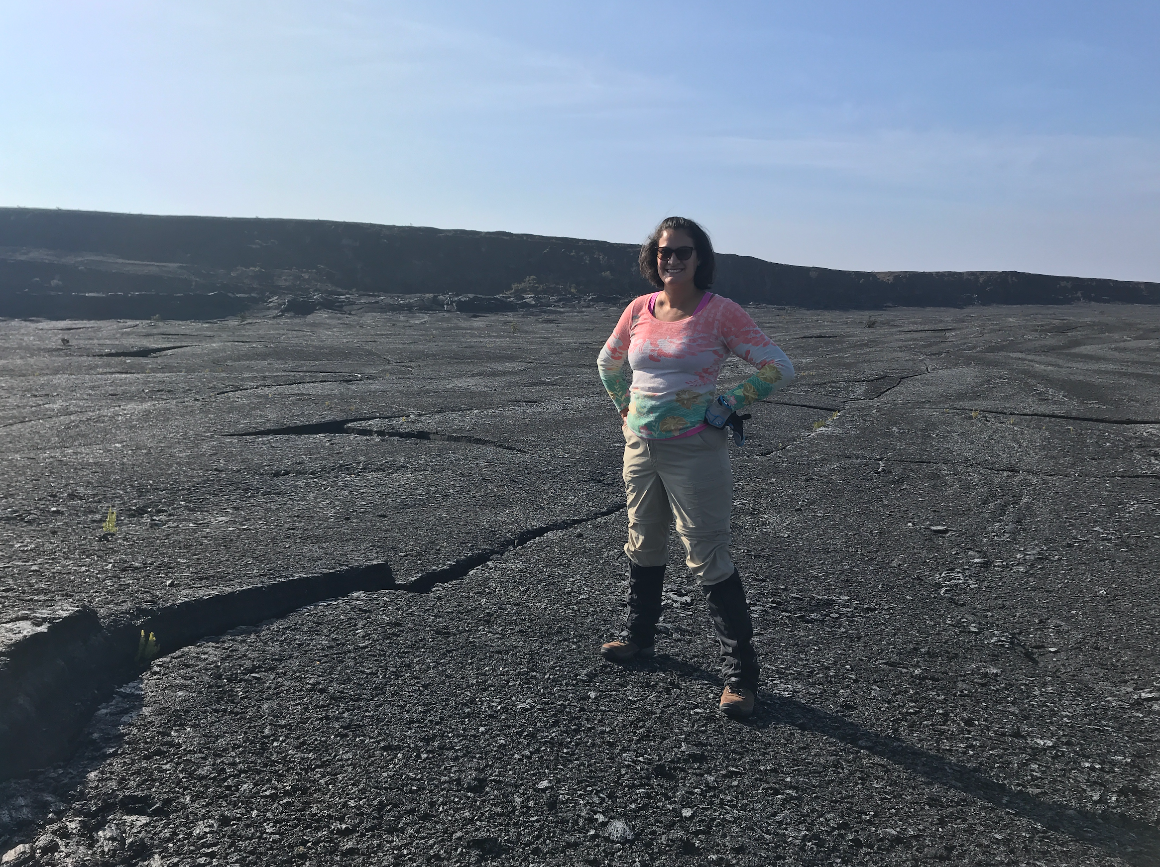
During her NASA career, Santiago-Materese traveled to Hawaii to investigate a planetary analog, a type of terrestrial environment that has very similar characteristics to those we might find on other worlds.
Image credit: Delia Santiago-Materese
At NASA Ames, Santiago-Materese held various roles, ranging from social media and open science to lunar sciences. She then became a program officer for the Solar System Workings program in the Planetary Science Division at NASA Headquarters as part of a detail, or temporary assignment. And then, she took off for Maryland along with her family.
Enabling Science
Santiago-Materese sums up her current role as a program scientist as the “science liaison” between NASA Headquarters and a mission. “When you do program scientist work, you might not be specialized or an expert in the exact science, but you need to be able to understand it and talk about it, to understand its importance,” she explains. “In general, we are supporting other people so they can do science.” In this endeavor, being someone who “gets more energy from working with people” is useful… and necessary: “You are having conversations all day long” with colleagues from different disciplines— from science and engineering to finance.
The Juno mission, in orbit around Jupiter since 2016, and Dragonfly, which is scheduled to launch no earlier than July 2028, are part of NASA’s New Frontiers program. Santiago-Materese also oversees the array of missions in the Discovery program, which includes ongoing science missions like Psyche and Lucy—heading to different asteroids—and future missions to Venus.
For Santiago-Materese, sharing her unconventional path can be valuable for students and youth in general, especially those who are unsure of what they want to do. “Your dream job,” she says, “you might not know it exists, or maybe it doesn’t exist today.” Beyond that, this zigzagging path has led her to accumulate experiences and relationships with different people, which she treasures even as she sets off for her next destination.
An Alien World
About two years out from Dragonfly’s launch, it is no surprise that this robotic mission takes up much of Santiago-Materese’s time. “Dragonfly feels like a combination of all my different experiences over time,” she reflects. And it signifies, to some extent, a return to her roots: it is an astrobiology mission. Although not designed to detect life, Dragonfly will investigate prebiotic chemistry: the chemical processes that could have led to the emergence of life on Earth.
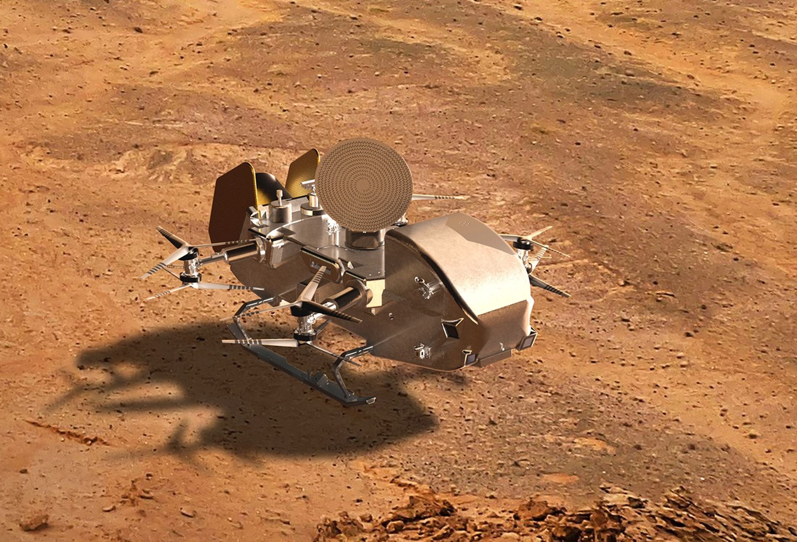
Digital concept of NASA’s Dragonfly lander on the surface of Saturn’s moon Titan.
NASA/Johns Hopkins APL/Steve Gribben
Dragonfly will embark on a journey of about six years to the surface of Titan. The spacecraft will carry an array of science instruments and will be the first NASA science mission to explore another world by flying from location to location. This car-sized rotorcraft will touch down at various geological sites of interest to analyze the moon’s composition and its habitability potential.
When it arrives at Titan, it will encounter a landscape that is strange and familiar at the same time: it could be a window into Earth’s remote past. This frozen world has a thick atmosphere and clouds drifting across the sky; dunes, lakes, rivers, canyons and mountains. Titan even has a process equivalent to our water cycle. However, on Titan, it is not water that flows but hydrocarbons, primarily methane and ethane. “It’s a more methane-based chemistry, so it is very alien, and that is what I really love about Titan,” says Santiago-Materese. And on this moon, organic molecules abound.
These molecules contain carbon and are used by all known forms of life. They are fundamental to understanding the origin of life, as they can be produced by both biological and non-biological processes. On Titan, these organic molecules fall to the surface and form dense deposits over its bedrock of water ice. Scientists believe that the complex chemistry precursor to life could be triggered there if provided with a little liquid water, such as that generated by an asteroid impact.
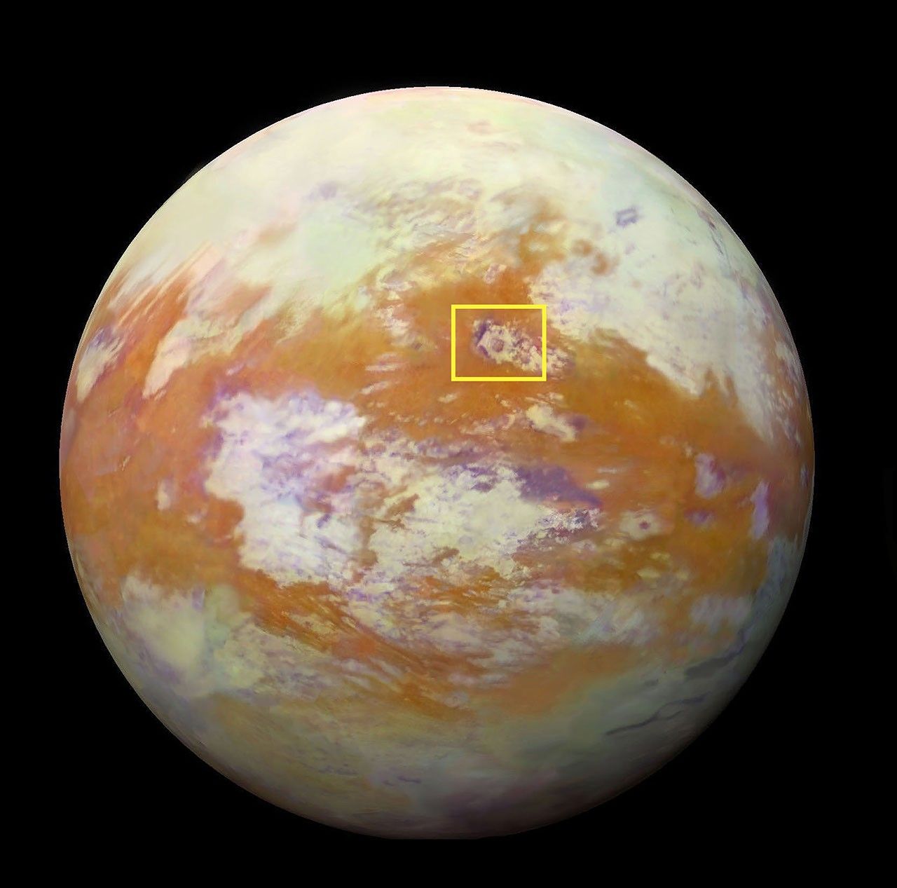
Selk Crater, an 80-kilometer (50-mile) diameter impact site highlighted in this infrared image of Titan, is a key destination for Dragonfly. The rotorcraft will touch down near Selk and explore various sites, analyzing the surface chemistry to investigate the frozen remains of what could have been prebiotic chemistry in development.
NASA/JPL-Caltech/University of Nantes/University of Arizona
Santiago-Materese is especially excited about what the Dragonfly Mass Spectrometer (DraMS) instrument will help discover. DraMS, designed and built at NASA’s Goddard Space Flight Center in Greenbelt, Maryland, will analyze samples from Titan’s surface. “The more complex things get, the more interesting things happen,” she says. “So I’m curious: just how complex do the molecules get? Will we find any interesting patterns?”
But in science, every time you ask a question, a new one arises. Dragonfly will try to answer several of them. “When you have a planet with complex chemistry but not life, what happens? What is there before life?” the program scientist wonders.
Titan, a valuable natural laboratory, “is going to completely change our understanding of what another world can be like,” she anticipates. In addition to what the scientific community expects to discover thanks to Dragonfly, Santiago-Materese is interested in the potential unexpected findings. “There are very defined science goals, but a lot of it is exploratory work,” she explains. “It is kind of nice to know that there is a big range [of possibilities], that we could be very surprised.”
By Noelia González, NASA’s Goddard Space Flight Center, Greenbelt, Maryland
Machine vision is becoming a practical part of Apple’s U.S. factory training strategy, giving smaller manufacturers access to techniques that help production systems inspect what they make. The recent opening of the Houston manufacturing training center extends that effort into a working electronics production campus, while courses developed with Michigan State University introduce businesses to image analysis, machine learning, and automated quality checks.
For a manufacturer, the attraction can be straightforward: finding a missing component before a product leaves the line, identifying a surface defect before more material is added, or recognizing an assembly error while it can still be corrected cheaply.
These are manageable problems with measurable costs. They also offer an accessible starting point for businesses interested in AI but unsure where it belongs inside their operations.
Machine Vision Enters the Manufacturing Curriculum
The Apple Manufacturing Academy’s current course catalog includes Machine Learning with Vision, a course introducing machine learning and deep learning through practical activities using Apple devices. It sits alongside instruction in automation, quality fundamentals, manufacturing data, maintenance, and process improvement.
That placement gives the subject useful context. A camera can produce an image, but a factory needs a decision: accept the part, flag it for review, check its position, or investigate a process that may be drifting out of tolerance.
Machine vision connects image capture to those operational decisions. Some applications use established rules to measure dimensions or identify patterns. Others use machine learning to recognize acceptable variations and defects that are difficult to describe through fixed rules.
The academy’s public description confirms introductory activities with Apple devices. It does not identify a particular iPhone, Mac configuration, software framework, or industrial camera package that every participant must use.
For smaller businesses, the educational value is learning how to define an inspection problem before purchasing equipment. A company that understands what it needs to detect can have a much more productive conversation with an automation supplier.
Houston Brings Training Closer to Production
Apple opened its 20,000-square-foot Advanced Manufacturing Center on August 13. According to the Houston opening announcement, the free program offers small and medium-sized businesses instruction in advanced manufacturing, interactive labs, and experience with representative production equipment.
The first cohort worked with machine learning for quality control and advanced automation. Participants also explored production challenges, used a holographic table, and assembled and laser etched a product.
The location adds context: the center occupies the same Houston facility that builds advanced AI servers and is scheduled to begin Mac mini manufacturing this year. Its teaching program includes final assembly principles and design considerations for printed circuit board assembly.
Houston is the company’s second U.S. manufacturing learning site, following the Detroit academy established with Michigan State University in August 2025. By the Houston opening, Apple said the academy had helped nearly 1,000 workers, students, and entrepreneurs.
That figure measures people reached through the program. It should not be interpreted as 1,000 factories already operating AI inspection systems.
Apple Machine Learning Adapters
A Useful Inspection Starts With a Specific Problem
Imagine a small business assembling control panels. Each panel needs the same set of connectors, positioned correctly before the enclosure closes. A machine vision station could check for a missing connector while the assembly remains accessible.
The value comes from catching that error at the right moment. Discovering it after packaging creates extra handling and rework. Discovering it after delivery may involve a return, a service visit, and an unhappy customer.
A useful pilot would therefore begin with that single inspection point. The business could compare the existing process with the assisted one, recording missed defects, unnecessary rechecks, inspection time, and the cost of correcting mistakes.
The camera is only part of the exercise. Workers must agree on what constitutes a defect, collect representative examples, and decide what happens when the result is uncertain.
Those decisions draw heavily on experience already present on the factory floor. An operator may know that an unusual mark is harmless, while a barely visible change in alignment predicts a later assembly problem. Turning that knowledge into consistent inspection criteria is valuable work in its own right.
These are examples of how manufacturers could apply the training, rather than projects Apple has announced for individual participants.
Teaching Machine Vision to Handle Ordinary Variation
A demonstration can look impressive when every part arrives clean, centered, and evenly lit. Production introduces variation: different surface finishes, reflections, changing positions, and batches that look slightly different while remaining within specification.
The inspection system must distinguish those acceptable differences from actual failures. Otherwise, it can reject good products or allow defective ones to continue.
Industrial vision supplier Cognex’s deployment guidance recommends validating systems across product models, defect types, and manufacturing lines. It also describes an approach in which automated inspection handles preliminary checks while experienced inspectors review borderline cases.
For a business learning machine vision, that offers a realistic way to introduce the technology. Employees can compare its decisions with their own, investigate disagreements, and determine whether the results justify extending its role.
An inspection system also needs an owner after installation. Someone must understand when a product change requires new examples, when equipment needs attention, and when performance has slipped. Training that responsibility into the workforce helps prevent an initially successful project from becoming an unreliable fixture.
Smaller Manufacturers Are Already Applying the Training
The academy’s reach extends beyond companies producing consumer electronics. In its May update on participating manufacturers, Apple highlighted Block Imaging, a Michigan business that services and refurbishes medical imaging equipment.
The company hosted visitors during the academy’s Spring Forum and described applying techniques learned from Apple engineers and Michigan State experts to its operations. Apple reported that the academy had supported more than 150 American businesses at that point.
The announcement did not identify a particular machine vision deployment at Block Imaging or publish a percentage improvement attributable to visual inspection. It does provide an example of the training reaching businesses whose work differs substantially from building an iPhone.
That wider participation could benefit Apple indirectly. More capable domestic manufacturers can support equipment maintenance, tooling, components, and specialized production services. Participation itself does not establish a supplier relationship, but the skills can be used across customers and industries.
Access Without a Large Training Budget
The academy’s participation information says eligible small and medium-sized U.S. manufacturers can take courses free of charge. Online learning includes on-demand materials and interactive modules, while in-person sessions add workshops and more personalized instruction.
Digital badges are available for different topics, and completed course materials remain accessible for review. That gives a business room to train an employee around existing production commitments and return to the material when an actual project begins.
Free instruction does not remove the eventual cost of cameras, lighting, integration, maintenance, or employee time. It can help a manufacturer understand those costs before committing to a system.
The first proposal brought back to the factory might be modest: inspect one recurring defect at one station and record the results for several weeks. A supervisor can then weigh the time saved against the extra reviews, maintenance, and mistakes. That is the kind of evidence a business owner can use when deciding whether to install a second station.
According to a new paper published this week in the Proceedings of the National Academy of Sciences, some of the smallest bees studied have photoreceptors as sharp as those of much larger honeybee drones.
For the first time in decades, NASA has rolled out one of its iconic astronaut training aircraft with a bold, new look.
The space agency debuted a new livery on one of its T-38 jets in celebration of its program to return astronauts to the Moon. The Artemis design retains nods to what made the "white rocket" immediately recognizable, but adds a new colorway and painted graphics to make clear where NASA is headed.
"This new 'Artemis' livery has a black and white paint scheme with blue and red stripes that separate those two paint schemes," said Sean Brady, who proposed and designed the new livery while serving as the T-38 project pilot in NASA's Aircraft Operations Division (AOD), part of the Flight Operations Directorate at Johnson Space Center in Houston. "The Artemis program logo in the back and a picture of the Moon is on the left and right side of the rear fuselage."
Charlotte Henry and Chuck Joiner catch up after a brief break to discuss the first looks at Silo Season 4, Neuromancer, and the return of Ted Lasso. The issue of adaptation versus original storytelling, speculation on Apple TV strategy are debated from the new leadership perspective. The hosts also share their expectations for upcoming releases. […]
A resource for checking Mac external-display support, Comcast’s move away from NBCUniversal, Peacock’s streaming and sports strategy, and whether broadband offers a stronger business model than media all started off this MacVoices Live! conversation. Chuck Joiner, David Ginsburg, Brian Flanigan-Arthurs, Ben Roethig, Eric Bolden, Marty Jencius, Jeff Gamet, Norbert Frassa, Jim Rea, and Web Bixby examine Apple Invites and question why so many Apple features launch with fanfare but receive little sustained development.
Charlotte Henry and Chuck Joiner examine Apple TV’s strategy through the expansion of Monarch: Legacy of Monsters, the theatrical release of Tenzing, and Eddie Cue’s Cannes Lions recognition. They compare Apple’s stated quality-over-quantity approach with Netflix’s engagement-first model, then consider F1 sequel plans and speculate on what smart glasses could mean for the streaming service from […]

 Login