The Moon’s polar regions may be less hostile to microbes than previously thought. This is the new finding from researchers at NASA and the University of Maryland in the US who say that future crewed missions to the lunar south pole will have to be carefully thought out to limit the unintended transfer of Earth life forms.
High ultraviolet radiation and temperatures make the Moon’s surface a harsh place and not somewhere bacteria and other micro-organisms can easily survive. This is particularly true for the equatorial regions, where all previous crewed missions have been sent. Things might be quite different at the lunar poles, however, since sunlight strikes these high-latitude regions at a low angle because of the Moon’s minimal tilt to the Sun of 1.5°. The result is long permanent shadows where it is cooler. The moonscape is also as rugged here as elsewhere with mountains and hills, which also cast shadows, and deep craters protected from the Sun’s heat and ultraviolet flux. These conditions allow for water ice too.
Because of these unique properties, future crewed missions, such as NASA’s Artemis IV, are scheduled to go to the Moon’s south pole, which has also been identified as a possible future location for a human outpost. The polar regions have already been observed by spacecraft such as ESA’s SMART-1, India’s Chandrayaan, Japan’s Kaguya and NASA’s Lunar Reconnaissance Orbiter. These provided a wealth of information that will be used to prepare future missions.
The problem is that no matter how stringent the sterilization procedures are prior to take-off, the astronauts on these missions will take microbes from Earth with them. Indeed, humans carry millions of microbes on their skin and even more in their bodies.
Landing sites for Artemis IV
To investigate whether microbes could survive in the polar regions, the researchers, led by Prabal Saxena, who works at NASA’s Goddard Space Flight Center, and Stefano Bertone at the University of Maryland, modelled how bacteria and fungi commonly found on human skin would behave in the environment of three candidate landing sites for the upcoming Artemis IV mission. The researchers began by making highly resolved spatial maps of the topography in these regions that included ruggedness, slopes and shadowing effects. They also modelled the UV exposure and temperature in these regions to identify specific locations where micro-organisms could survive for at least 24 h.
“Since the temperatures at the lunar poles are rarely high enough to kill bacteria and low temperatures can preserve microbes on Earth, UV radiation is generally likely to be more dangerous in these regions, says Saxena. “We therefore analysed UV fluxes at finer spatial scales using a technique called ray tracing, and for some regions, included optical effects such as reflection and refraction as sunlight hits the Moon’s surface, leveraging updated LOLA-based topography maps on a scale of 5 m/pixel.”
Understanding how sunlight behaves at the poles is crucial, he adds. “Since the Moon has a very small axial tilt, the Sun appears to hover just above the horizon here, so even small hills and rocks can prevent light from reaching lower-lying ground, creating small, shadowed areas protected from UV rays.”
Up to seven days survival
The simulations revealed that the bacteria and fungi studied could survive in certain niches for up to or potentially beyond seven days. One particular fungus, the Aspergillus, is particularly resistant to UV radiation and could potentially survive in 15 to 30% of the areas assessed, even those that receive some sunlight during the lunar winter. The reconstructions also showed that all five microbes in this study, Bacillus, Deinococcus, Staphylococcus, Aspergillus and Fusarium could possibly survive in certain areas of the De Gerlache Rim’s permanently shaded regions, including when scattered UV light is incorporated into the simulations.
Survival does not mean growth (which requires active metabolism and potential reproduction), however, stresses Saxena. Indeed, surviving microbes are in a dormant, so-called cryptobiotic state and would only grow if the conditions were amenable to life – which is not the case for the Moon as we currently understand it.
The work could apply beyond the Moon, he says. Indeed, a number of different airless bodies such as Mercury, Ceres, some asteroids and comets and exoplanets that may have similar properties could also have potential survivable niches for microbial life. Understanding how these niches may exist, how life may be transferred to them and how human exploration may leave its mark will all serve as a key testbed for future potential human exploration of Mars, which likely has far more habitable environments.
“We need to understand what was there before us, because when we search for signs of life beyond our planet on these bodies, we will want to make sure it’s not stuff we brought,” says Saxena.
Across the stories today, a common thread emerges: the planet is speaking in signals — some subtle, some deafening — and the question is whether our institutions can listen fast enough to act.
Start with the signals themselves. El Niño has surged to record strength weeks ahead of schedule, and its fingerprints are already visible — from Hurricane Polo’s explosive intensification in the Pacific to the climate volatility rippling through global weather systems. In the UK, an aphid outbreak wiped out 30 million lettuce heads almost overnight, a small but telling example of how shifting conditions can upend food systems in ways no one budgets for. In Malawi, an unexplained weed overgrowth has choked Chia Lagoon, stranding farmers and fishers in flooded fields nearly seven months after the rains should have drained. These aren’t isolated oddities. They’re the planet’s early warning system, written in crop yields and clogged waterways.
Then there’s the human response — uneven, but not absent. Germany’s landmark pledge to phase out fossil fuels by 2045 marks a rare moment of policy catching up to urgency, moving beyond vague “carbon neutrality” language toward something more concrete. The UK’s decision to declassify a once-suppressed intelligence report — warning that climate breakdown is a direct threat to global security — suggests governments are quietly acknowledging what scientists have said for years, even if political will lags behind. And at UN climate talks in New York, amid what The Guardian describes as a genuinely grim mood, solar power’s continued growth offered rare, tangible hope. As Al Gore noted twenty years after An Inconvenient Truth, he’s surprised by the ferocity of fossil fuel pushback — but still believes, cautiously, that the fight can be won.
Behind the numbers are real communities adapting in real time. In the Andes, villagers near Villa de Arma are turning to ancient wetland systems as glaciers they once walked across vanish into bare rock. In Guam, resident Leevin Camacho learned his family’s water contained a pesticide banned since 1987 — a stark reminder that militarization and environmental cost are often intertwined, especially in the Pacific. And in Sarawak, Indigenous communities are still reckoning with displacement from the Bakun megadam three decades later, a cautionary tale as the world races toward a “clean” energy future that doesn’t always ask who pays for it.
It’s a reminder that progress and pressure often arrive together. Endangered birds on South Australia’s Eyre Peninsula won last-minute protection from a rocket launch site — a genuine conservation victory — even as a Norfolk Broads housing levy was quietly slashed, raising fears that environmental safeguards elsewhere are eroding. Meanwhile, olive ridley sea turtles nesting for the first time ever on California beaches offer something rarer: wonder. A signal, too, but one that invites curiosity rather than alarm — proof that the natural world is still capable of surprising us.
As the week unfolds, all eyes will be on whether momentum from Climate Week — bolstered even by a monster from Sesame Street reminding children it’s okay to feel both fear and courage — translates into follow-through. The data, the disasters, and the small human stories all point the same direction: the era of asking “if” is over. What remains is the harder work of “how fast,” and “for whom.”
After nearly two decades, America's war on CO2 is being brought to a well-deserved end, with Lee Zeldin, the head of Trump's EPA, scrapping Biden-era green power plant rules, says Tilak Doshi.
A zoomed-in view of the Moon made from images from NASA’s Lunar Reconnaissance Orbiter Camera. (More information at the bottom of article.)
Credits: NASA Goddard/Intuitive Machines/Robert Wagner
It started as a routine data-quality check. But as Robert Wagner, a scientist with NASA’s Lunar Reconnaissance Orbiter (LRO), scanned a giant Moon map on his computer screen, an unusually large bright spot circled by a dark halo caught his eye, as it implied that surface material in that area had been shaken up.
“I just stopped, dropped everything, and started looking into what that spot was,” said Wagner, an image-processing specialist from Intuitive Machines who works with data from the Lunar Reconnaissance Orbiter Camera (LROC) system.
By comparing before and after images of the Moon, Wagner realized he had discovered the largest, newly formed crater ever found in the solar system, as scientists reported Wednesday in Science Advances. This discovery highlights the value of NASA’s Moon orbiter data in studying a dynamic landscape as the agency advances a sustained human presence and expanded scientific and commercial activity on the Moon.
A zoomed-in view of McGetchin crater, circled on the left, next to a “before” image on the right. The panel on the left is made from images captured by NASA’s Lunar Reconnaissance Orbiter Wide-Angle Camera in summer 2025; the right panel was made from images taken in spring 2011. The white spot is not the crater itself, but rather material flung out of the crater, which formed when a rock, possibly this size of a three- to six‑story building, crashed into the Moon between April 11 and May 22, 2024 – a once-in-a-century event, as scientists reported on Sept. 15, 2026, in a pair of papers in Science Advances. The area shown in the images is 38 miles wide.
NASA Goddard/Intuitive Machines/Robert Wagner
Officially named McGetchin after pioneering lunar scientist Tom McGetchin, the crater formed on the Moon’s eastern edge sometime between April 11 and May 22, 2024, after a comet or asteroid the size of a three- to six-story building hit the surface.
The crash left a crater, 728 feet wide, that spans the length of two football fields. And at 141 feet deep, the crater could fit three vertically stacked yellow school buses.
Scientists estimate that an impact of this magnitude happens on the Moon about once in a century or even longer.
Moon takes some hits
For more than 17 years, LRO has been circling the Moon and using its seven instruments to map the topography, surface composition, temperature, and radiation environment there. The spacecraft’s team has identified at least 1,000 new impact craters throughout the mission and flagged 100,000 more surface changes from an object smashing into the Moon or from the debris that flung out after.
With no atmosphere to slow them or burn them up, space rocks and other objects easily reach the lunar surface. Most are much smaller compared to the object that carved out McGetchin crater. The smallest craters scientists can distinguish from LRO images are about 30 feet wide, the length of a three-story building laid on its side, made by rocks about 43 inches wide, the size of a monster-truck tire. Scientists estimate that impacts of this scale produce about 140 new craters across the Moon each year. But most new ones are made by microscopic projectiles that leave holes too small to identify in orbital images.
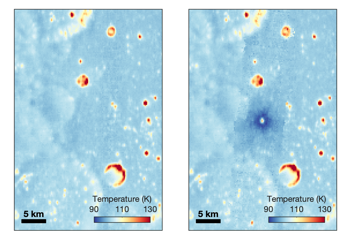
With its numerous instruments, the spacecraft can observe changes to the lunar surface that aren’t apparent in the LROC images alone. After the crater was discovered, scientists working with LRO’s thermal instrument, Diviner, made follow-up observations of the site. They found a 4-mile-wide area around the crater that is about 16 degrees Fahrenheit cooler at night than its surroundings.
This animated image set shows an area on the eastern limb of the Moon before and after McGetchin crater formed there sometime between April 11 and May 22, 2024. The post-impact image was constructed using data taken by NASA’s Lunar Reconnaissance Orbiter (LRO) thermal instrument, Diviner, between Nov. 15, 2025, and Feb. 18, 2026, after scientists discovered the crater in visible-light images taken by LRO’s Wide-Angle Camera. Pre-impact temperatures are from the Diviner Global High-Resolution Mosaics (GHRM). The crater formed on the Moon after a comet or asteroid, possibly the size of a six-story building, hit the surface in a rare, once-in-a-century collision. The dark blue strip that flashes into view reveals a 4-mile-wide “cold spot” around the crater that is about 16 degrees Fahrenheit cooler at night than its surroundings. This cooling happens because an impact fluffs up regolith around a crater, making it less dense and therefore less able to retain heat. Scientists on the Diviner team reported this finding in a paper published on Sept. 16, 2026, in Science Advances. The red and yellow spots indicate areas typically associated with rocks excavated by long-ago impacts which, though still at cryogenic temperatures like their surroundings, remain slightly warmer at night.
NASA Goddard/UCLA/JHU APL
Reporting in a second paper Wednesday in the same journal, researchers say that the cooling happens because the impact fluffs up the regolith around the crater, making it less dense and therefore less able to retain heat.
The large extent of this “cold spot” is striking, scientists say, because it shows that impacts can modify the Moon’s surface far beyond the crater itself. These physical changes could affect how rover wheels interact with the surface, for instance.
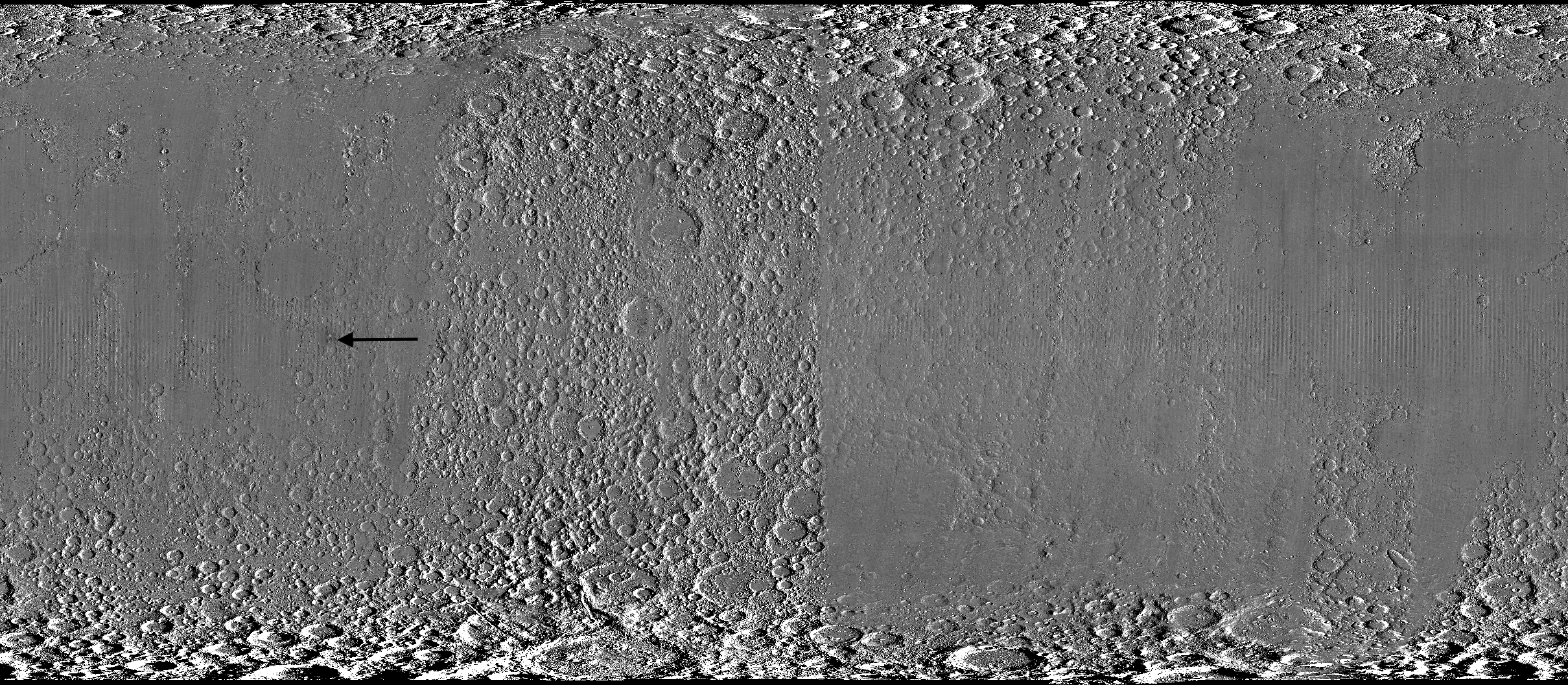
A global view of the Moon made by stitching together hundreds of images from the Wide-Angle Camera aboard NASA’s Lunar Reconnaissance Orbiter (LRO). Robert Wagner, image processing specialist for LRO, made this map using two sets of mages taken several years apart. He used a software designed to highlight any changes between the two sets. Anything that stayed the same turned gray; anything different showed up as bright or dark patches. A black arrow just left of center points to McGetchin crater.
NASA Goddard/Intuitive Machines/Robert Wagner
Road to discovery
The LROC system collects images from about 60 miles above the Moon as LRO loops from pole to pole. The system includes two cameras that capture high‑resolution black‑and‑white images and one camera for moderate‑resolution multispectral images. Over the years and thousands of passes, scientists have built maps detailed enough to spot not only new craters, but also landslides, landers, seismic faults, and even hints of lava tubes.
LROC scientists regularly analyze close-up images of small portions of the Moon’s surface taken by the Narrow-Angle Camera. Using these images, they look for changes that are typically less than 30 feet across. But every few years the team searches for large (wider than 150 feet) features by creating global Moon maps and comparing them to older versions.
An overhead, close-up view of McGetchin crater that was taken on Dec. 5, 2025, by NASA’s Lunar Reconnaissance Orbiter (LRO) Narrow-Angle Camera (NAC). After the crater was discovered on Oct. 24, 2025, in global images from LRO’s Wide-Angle Camera, which captures broad views with pixels the size of American football fields, scientists turned to the NAC, which takes much sharper views at about 3 feet per pixel. The NAC images, taken as LRO flew over the impact site again, revealed the crater size, shape, and how the surrounding terrain was affected by the impact that carved McGetchin. The image covers an area that’s ¾ mile wide.
NASA Goddard/Intuitive Machines
This view from the side (55° away from straight down) towards the east, covers an area of the Moon that’s about 1.5 miles wide. It was taken by NASA’s Lunar Reconnaissance Orbiter Narrow-Angle Camera on March 3, 2026.
NASA Goddard/Intuitive Machines
That’s what Wagner was doing on Oct. 24, 2025, when he came across McGetchin. Using images from LROC’s Wide-Angle Camera, which captures broad views with pixels the size of football fields, he stacked hundreds of “before” and “after” frames with software designed to highlight change. Anything that stayed the same turned gray while anything different showed up as bright or dark patches.
While the process sounds straightforward, spotting real craters requires a lot of manual work. The software flags every tiny shift in lighting or shadow, generating hundreds of false alarms. For this reason, Wagner typically verifies the software, looking for small fuzzy halos around pixel‑wide bright points, which indicate splashes of regolith around a new crater.
Spanning hundreds of pixels, McGetchin stood out immediately. “It was by far the most obvious impact debris pattern I’ve ever seen in one of these images,” Wagner said.
After his discovery, scientists turned to the Narrow-Angle Camera, which takes much sharper views at about 3 feet per pixel. This camera’s close-up images, taken as LRO flew over the impact site again, revealed the crater size, shape, and how the surrounding terrain was affected. These images also helped researchers estimate the size and force of the rock fragment that formed the new crater, details that are expected to appear in a future paper.
Banner image caption: A zoomed-in view of the Moon, with debris around McGetchin crater visible as a white spot circled by a dark halo just right of center of the image (marked with black arrows). This is the view that Robert Wagner saw on Oct. 24, 2025, during a routine data-quality check. Wagner is an image processing specialist for NASA’s Lunar Reconnaissance Orbiter Camera, a system of three cameras. Using images from the Wide-Angle Camera (WAC), which captures broad views with pixels the size of American football fields, he stacked hundreds of images captured by WAC over the last several years with software designed to highlight change. Anything that stayed the same is gray; anything that changed showed up as bright or dark patches. The stripes in the image are due to slight changes in lighting between the older and newer images. This image composite shows an area of the Moon approximately 900 miles across.
About the Author
Lonnie Shekhtman
Senior Science Writer
Shekhtman helps communicate NASA planetary science to the world through news and feature stories on NASA.gov, videos for NASA+ and YouTube, and by working with the media. She reports on lunar and Mars science and exploration; NASA's search for life; missions to Venus, Titan, and Jupiter's Trojan asteroids; and many other topics related to NASA's exploration of our solar system and beyond.
Scientists discovered a crater on the Moon that formed sometime between April 11 and May 22, 2024, after a comet or asteroid the size of a three- to six-story building hit the surface.
The crash left a crater, 728 feet wide, that spans the length of two football fields. And at 141 feet deep, the crater could fit three vertically stacked yellow school buses.
A zoomed-in view of the Moon made from images from NASA’s Lunar Reconnaissance Orbiter Camera. (More information at the bottom of article.)
Credits: NASA Goddard/Intuitive Machines/Robert Wagner
It started as a routine data-quality check. But as Robert Wagner, a scientist with NASA’s Lunar Reconnaissance Orbiter (LRO), scanned a giant Moon map on his computer screen, an unusually large bright spot circled by a dark halo caught his eye, as it implied that surface material in that area had been shaken up.
“I just stopped, dropped everything, and started looking into what that spot was,” said Wagner, an image-processing specialist from Intuitive Machines who works with data from the Lunar Reconnaissance Orbiter Camera (LROC) system.
By comparing before and after images of the Moon, Wagner realized he had discovered the largest, newly formed crater ever found in the solar system, as scientists reported Wednesday in Science Advances. This discovery highlights the value of NASA’s Moon orbiter data in studying a dynamic landscape as the agency advances a sustained human presence and expanded scientific and commercial activity on the Moon.
A zoomed-in view of McGetchin crater, circled on the left, next to a “before” image on the right. The panel on the left is made from images captured by NASA’s Lunar Reconnaissance Orbiter Wide-Angle Camera in summer 2025; the right panel was made from images taken in spring 2011. The white spot is not the crater itself, but rather material flung out of the crater, which formed when a rock, possibly this size of a three- to six‑story building, crashed into the Moon between April 11 and May 22, 2024 – a once-in-a-century event, as scientists reported on Sept. 15, 2026, in a pair of papers in Science Advances. The area shown in the images is 38 miles wide.
NASA Goddard/Intuitive Machines/Robert Wagner
Officially named McGetchin after pioneering lunar scientist Tom McGetchin, the crater formed on the Moon’s eastern edge sometime between April 11 and May 22, 2024, after a comet or asteroid the size of a three- to six-story building hit the surface.
The crash left a crater, 728 feet wide, that spans the length of two football fields. And at 141 feet deep, the crater could fit three vertically stacked yellow school buses.
Scientists estimate that an impact of this magnitude happens on the Moon about once in a century or even longer.
Moon takes some hits
For more than 17 years, LRO has been circling the Moon and using its seven instruments to map the topography, surface composition, temperature, and radiation environment there. The spacecraft’s team has identified at least 1,000 new impact craters throughout the mission and flagged 100,000 more surface changes from an object smashing into the Moon or from the debris that flung out after.
With no atmosphere to slow them or burn them up, space rocks and other objects easily reach the lunar surface. Most are much smaller compared to the object that carved out McGetchin crater. The smallest craters scientists can distinguish from LRO images are about 30 feet wide, the length of a three-story building laid on its side, made by rocks about 43 inches wide, the size of a monster-truck tire. Scientists estimate that impacts of this scale produce about 140 new craters across the Moon each year. But most new ones are made by microscopic projectiles that leave holes too small to identify in orbital images.
With its numerous instruments, the spacecraft can observe changes to the lunar surface that aren’t apparent in the LROC images alone. After the crater was discovered, scientists working with LRO’s thermal instrument, Diviner, made follow-up observations of the site. They found a 4-mile-wide area around the crater that is about 16 degrees Fahrenheit cooler at night than its surroundings.
This animated image set shows an area on the eastern limb of the Moon before and after McGetchin crater formed there sometime between April 11 and May 22, 2024. The post-impact image was constructed using data taken by NASA’s Lunar Reconnaissance Orbiter (LRO) thermal instrument, Diviner, between Nov. 15, 2025, and Feb. 18, 2026, after scientists discovered the crater in visible-light images taken by LRO’s Wide-Angle Camera. Pre-impact temperatures are from the Diviner Global High-Resolution Mosaics (GHRM). The crater formed on the Moon after a comet or asteroid, possibly the size of a six-story building, hit the surface in a rare, once-in-a-century collision. The dark blue strip that flashes into view reveals a 4-mile-wide “cold spot” around the crater that is about 16 degrees Fahrenheit cooler at night than its surroundings. This cooling happens because an impact fluffs up regolith around a crater, making it less dense and therefore less able to retain heat. Scientists on the Diviner team reported this finding in a paper published on Sept. 16, 2026, in Science Advances. The red and yellow spots indicate areas typically associated with rocks excavated by long-ago impacts which, though still at cryogenic temperatures like their surroundings, remain slightly warmer at night.
NASA Goddard/UCLA/JHU APL
Reporting in a second paper Wednesday in the same journal, researchers say that the cooling happens because the impact fluffs up the regolith around the crater, making it less dense and therefore less able to retain heat.
The large extent of this “cold spot” is striking, scientists say, because it shows that impacts can modify the Moon’s surface far beyond the crater itself. These physical changes could affect how rover wheels interact with the surface, for instance.
A global view of the Moon made by stitching together hundreds of images from the Wide-Angle Camera aboard NASA’s Lunar Reconnaissance Orbiter (LRO). Robert Wagner, image processing specialist for LRO, made this map using two sets of mages taken several years apart. He used a software designed to highlight any changes between the two sets. Anything that stayed the same turned gray; anything different showed up as bright or dark patches. A black arrow just left of center points to McGetchin crater.
NASA Goddard/Intuitive Machines/Robert Wagner
Road to discovery
The LROC system collects images from about 60 miles above the Moon as LRO loops from pole to pole. The system includes two cameras that capture high‑resolution black‑and‑white images and one camera for moderate‑resolution multispectral images. Over the years and thousands of passes, scientists have built maps detailed enough to spot not only new craters, but also landslides, landers, seismic faults, and even hints of lava tubes.
LROC scientists regularly analyze close-up images of small portions of the Moon’s surface taken by the Narrow-Angle Camera. Using these images, they look for changes that are typically less than 30 feet across. But every few years the team searches for large (wider than 150 feet) features by creating global Moon maps and comparing them to older versions.
An overhead, close-up view of McGetchin crater that was taken on Dec. 5, 2025, by NASA’s Lunar Reconnaissance Orbiter (LRO) Narrow-Angle Camera (NAC). After the crater was discovered on Oct. 24, 2025, in global images from LRO’s Wide-Angle Camera, which captures broad views with pixels the size of American football fields, scientists turned to the NAC, which takes much sharper views at about 3 feet per pixel. The NAC images, taken as LRO flew over the impact site again, revealed the crater size, shape, and how the surrounding terrain was affected by the impact that carved McGetchin. The image covers an area that’s ¾ mile wide.
NASA Goddard/Intuitive Machines
This view from the side (55° away from straight down) towards the east, covers an area of the Moon that’s about 1.5 miles wide. It was taken by NASA’s Lunar Reconnaissance Orbiter Narrow-Angle Camera on March 3, 2026.
NASA Goddard/Intuitive Machines
That’s what Wagner was doing on Oct. 24, 2025, when he came across McGetchin. Using images from LROC’s Wide-Angle Camera, which captures broad views with pixels the size of football fields, he stacked hundreds of “before” and “after” frames with software designed to highlight change. Anything that stayed the same turned gray while anything different showed up as bright or dark patches.
While the process sounds straightforward, spotting real craters requires a lot of manual work. The software flags every tiny shift in lighting or shadow, generating hundreds of false alarms. For this reason, Wagner typically verifies the software, looking for small fuzzy halos around pixel‑wide bright points, which indicate splashes of regolith around a new crater.
Spanning hundreds of pixels, McGetchin stood out immediately. “It was by far the most obvious impact debris pattern I’ve ever seen in one of these images,” Wagner said.
After his discovery, scientists turned to the Narrow-Angle Camera, which takes much sharper views at about 3 feet per pixel. This camera’s close-up images, taken as LRO flew over the impact site again, revealed the crater size, shape, and how the surrounding terrain was affected. These images also helped researchers estimate the size and force of the rock fragment that formed the new crater, details that are expected to appear in a future paper.
Banner image caption: A zoomed-in view of the Moon, with debris around McGetchin crater visible as a white spot circled by a dark halo just right of center of the image (marked with black arrows). This is the view that Robert Wagner saw on Oct. 24, 2025, during a routine data-quality check. Wagner is an image processing specialist for NASA’s Lunar Reconnaissance Orbiter Camera, a system of three cameras. Using images from the Wide-Angle Camera (WAC), which captures broad views with pixels the size of American football fields, he stacked hundreds of images captured by WAC over the last several years with software designed to highlight change. Anything that stayed the same is gray; anything that changed showed up as bright or dark patches. The stripes in the image are due to slight changes in lighting between the older and newer images. This image composite shows an area of the Moon approximately 900 miles across.
About the Author
Lonnie Shekhtman
Senior Science Writer
Shekhtman helps communicate NASA planetary science to the world through news and feature stories on NASA.gov, videos for NASA+ and YouTube, and by working with the media. She reports on lunar and Mars science and exploration; NASA’s search for life; missions to Venus, Titan, and Jupiter’s Trojan asteroids; and many other topics related to NASA’s exploration of our solar system and beyond.
Scientists discovered a crater on the Moon that formed sometime between April 11 and May 22, 2024, after a comet or asteroid the size of a three- to six-story building hit the surface.
The crash left a crater, 728 feet wide, that spans the length of two football fields. And at 141 feet deep, the crater could fit three vertically stacked yellow school buses.
On Sept. 10, 2026, NASA commemorated the completed repairs of the Guam Remote Station’s central antenna with a ribbon-cutting ceremony.
Members of NASA, the Governor’s Office of Guam, military personnel, and family members gathered to celebrate the Guam Remote Station’s return to operations.
NASA
The ribbon-cutting event was held in front of the repaired central antenna. As of 2026, the newly hardened station has withstood two super typhoons more powerful than Mawar with minimal damage.
SCaN Deputy Manager for Network Operations Jena Garrahy addresses members of the Guam Remote Station ribbon-cutting event.
NASA
Guam Remote Station Site Manager Kristopher Copple was among those recognized during the ceremony.
Jena Garrahy (right), SCaN Deputy Manager for Network Operations, presents a certificate of recognition to Guam Remote Station Site Manager Kristopher Copple (left).
NASA
NASA’s Guam Remote Station is key to the Tracking and Data Relay Satellite (TDRS) constellation maintaining continuous communications with the International Space Station.
An artist’s concept of the International Space Station using NASA’s Tracking and Data Relay Satellite (TDRS) fleet to transmit data to Earth.
NASA
A 2023 aerial photo of the Guam Remote Station prior to Super Typhoon Mawar landing on the island.
Satellite image of NASA remote ground terminal located in Dededo area, Guam, released by U.S. commercial satellite company MAXAR.
MAXAR
An aerial photo of the Guam Remote Station immediately after Super Typhoon Mawar struck the station. of the station’s three ground antennas were demolished.
Satellite image of NASA remote ground terminal located in Dededo area, Guam, released by U.S. commercial satellite company MAXAR.
MAXAR
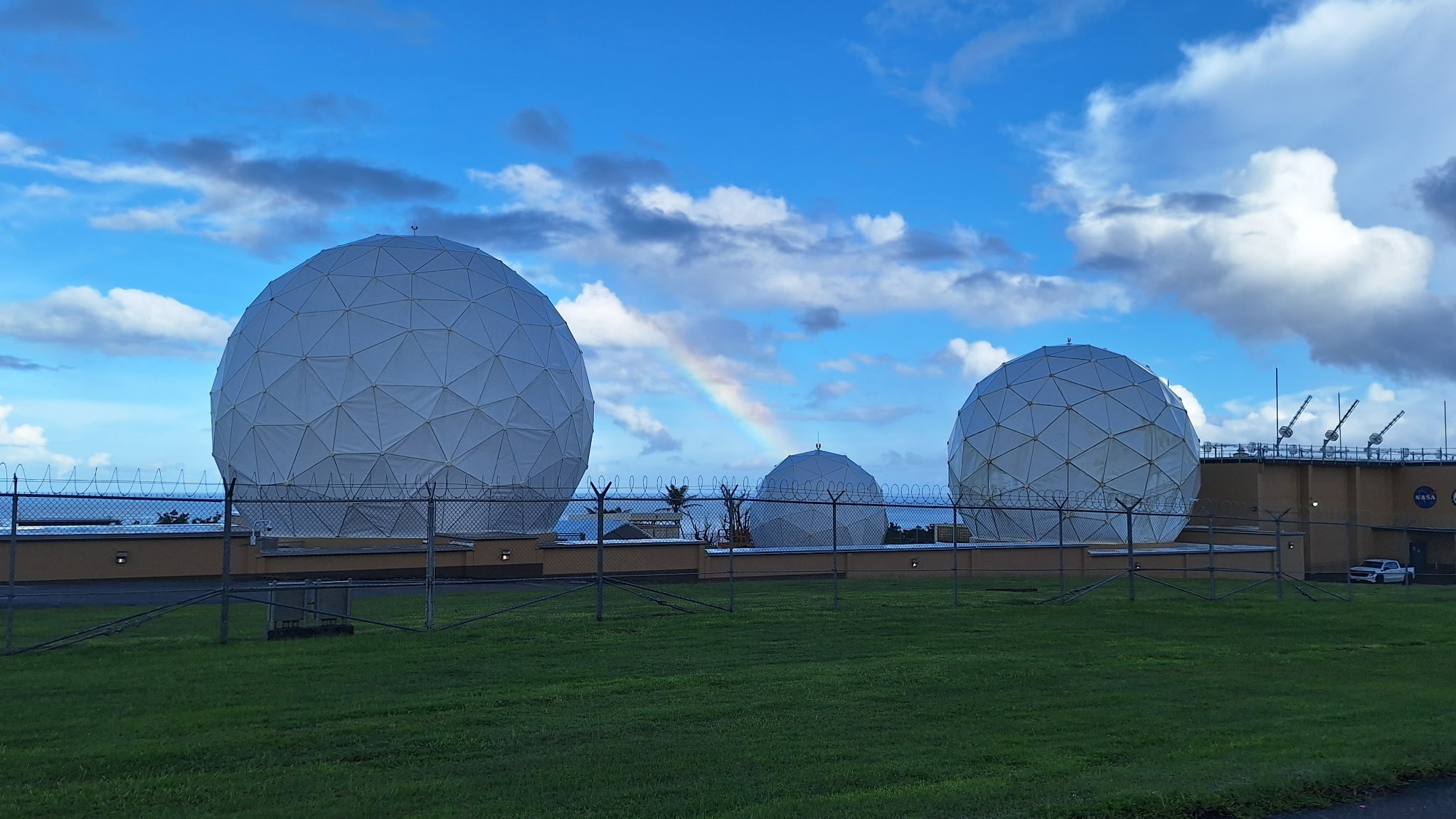
NASA celebrated the full restoration of its Guam Remote Station with a ribbon-cutting on Sept. 10, closing out more than three years of recovery after Super Typhoon Mawar devastated the site in 2023. Engineers from across the agency completed the final and most complex step of the rebuild on July 1, when they returned the station’s central antenna to service.
A rainbow arcs over the newly repaired Guam Remote Station antennas.
NASA
For nearly three decades, the Guam Remote Station has been one of three ground stations supporting NASA’s Tracking and Data Relay Satellites, or TDRS, a critical part of the Near Space Network. From 22,000 miles above Earth, the relays link spacecraft in low Earth orbit with the ground, allowing flight controllers to communicate with astronauts, command spacecraft, and receive mission data. The Guam station alone closes the “Zone of Exclusion,” a stretch of orbit beyond the relays’ line of sight. Without it, the International Space Station can lose contact with Earth for up to 20 minutes of every 90-minute orbit, an unacceptable risk for crewed missions.
On May 24, 2023, the Category 4 super typhoon struck Guam with 185 mph winds and more than 28 inches of rain, destroying two 16.5-meter antennas and damaging an 11-meter north antenna and the Inter Facility Link building at NASA’s station. The Zone of Exclusion reopened for the first time since 1998, cutting TDRS coverage to about 85% of a spacecraft’s orbit.
NASA made emergency repairs to the least-damaged antenna and borrowed two mobile terminals from the U.S. Army to expand coverage. The patchwork restored partial service within months, in time for a November 2023 spacewalk.
In early 2025, Congress dedicated disaster-relief funding to rebuild the ground station and harden the network against future storms. Construction began that summer and finished in summer 2026, when the rebuilt central antenna rejoined TDRS operations and the Zone of Exclusion closed once more. The same appropriation funded critical upgrades at three additional Near Space Network ground stations.
The return to service of the Guam Remote Station’s central antenna represents far more than the restoration of a critical piece of infrastructure — it is a testament to the dedication, resilience, and ingenuity of the people who made it possible.
Jena Garrahy
SCaN Deputy Program Manager for Network Operations
At the ribbon-cutting, representatives from NASA’s SCaN (Space Communications and Navigation) Division joined the station’s workforce and local leaders to mark the central antenna’s return to service. The Guam team, which led debris removal, site security, and on-island recovery, was recognized for its work to keep NASA connected to its missions through the outage and rebuild. A companion ceremony at NASA’s White Sands Complex in Las Cruces, New Mexico, honored the engineers and specialists across SCaN who supported the recovery off island.
“The return to service of the Guam Remote Station’s central antenna represents far more than the restoration of a critical piece of infrastructure — it is a testament to the dedication, resilience, and ingenuity of the people who made it possible,” said Jena Garrahy, Deputy Program Manager for Network Operations. “Through long days, challenging conditions, and unexpected obstacles, this team remained focused on the missions that depend on these critical assets every day.”
The Near Space Network is funded by SCaN, a division of NASA’s Research and Technology Mission Directorate, at the agency’s Headquarters in Washington. The network is operated out of NASA’s Goddard Space Flight Center in Greenbelt, Maryland. Repairs of the Guam Remote Station were managed out of NASA’s Glenn Research Center in Cleveland.
About the Author
Korine Powers
Lead Writer and Communications Strategist
Korine Powers, Ph.D. is a writer for NASA's SCaN (Space Communications and Navigation) Program office and covers emerging technologies, commercialization efforts, exploration activities, and more.
Across the stories today, a common thread emerges: the boundaries we once drew around “the environment” — between land and sea, sky and orbit, economy and ecology — keep dissolving, revealing how deeply intertwined these systems have become.
Start with the sky, in more ways than one. The US government’s confirmation that it has deployed a weapon in Earth’s orbit marks a genuine turning point, not just for defense policy but for how we think about the commons above our heads. Space has long been treated as neutral ground; now it’s becoming contested territory, raising quiet but urgent questions about debris, escalation, and what “environment” even means when it extends past the atmosphere. Meanwhile, back on solid ground, the UK’s climate advisers delivered a pointed message to Heathrow: a third runway cannot proceed unless airlines help pay for the emissions it would unleash, potentially through carbon removal costs. It’s a small but telling signal that growth and climate accounting are becoming inseparable in policy conversations — expansion is no longer a given, even for infrastructure long considered inevitable.
That tension between growth and limits runs through much of today’s coverage. A Guardian analysis found that the world’s twenty largest private equity firms back energy portfolios emitting more greenhouse gases than all but three countries on Earth — a stark reminder that climate accountability often hides behind layers of finance most people never see. In Venezuela, a US-backed push for “legitimate” mining and a new oil megadeal are drawing warnings from environmental and human rights groups who see familiar risks dressed in new language. And in Guinea-Bissau, industrial fishmeal factories are quietly hollowing out a food fish that coastal communities have relied on for generations. Behind the numbers are real communities adapting in real time — from Vietnamese fishers losing thousands of dollars per vessel to tangled plastic waste, to Dhaka residents like Yeasmin Begum, who has spent her life breathing the smoke of a landfill she never chose to live beside.
Yet alongside these pressures, the day’s coverage also points to growing momentum around resilience and repair. Ukrainians are turning to rooftop solar to keep homes running amid bombardment — a portrait of adaptation born from necessity. A Congolese NGO now co-manages a national reserve for the first time, a homegrown model of stewardship. Moon bears rescued from bile farms are stretching their limbs in Suffolk enclosures, and three wild dog brothers wandered 2,500 miles across Zambia in search of a mate, offering an unlikely note of hope for their species. Even Griffith Park’s mountain lion — photographed beneath the Hollywood sign — helped inspire the world’s largest wildlife crossing, proof that a single image can shift infrastructure decisions.
It’s a reminder that progress and pressure often arrive together. Some communities are innovating their way through crisis; others, like the land defenders now forming self-defense units amid rising violence, are simply trying to survive it. As Brazil’s upcoming election looms over the Amazon’s future, and Chief Raoni Metuktire — one of its most storied protectors — enters palliative care, the coming months may reveal whether today’s momentum toward stewardship can outpace the forces pulling the other way.
Russia launched a cargo mission toward the International Space Station today (Sept. 16), delivering the freighter spacecraft to orbit for a three-day rendezvous journey.
The robotic Progress 96 spacecraft lifted off atop a Soyuz rocket from the Russian-run Baikonur Cosmodrome in Kazakhstan today at 9:33a.m. EDT (1333 GMT).
From engine ignition through solar array deployment on the spacecraft, the Progress 96 launch was completely nominal. It was "a flawless launch," said NASA's Rob Navias during the mission's livestream this morning, with "an excellent climb to orbit by the Soyuz booster."
Roscosmos' Progress 96 cargo spacecraft launches from the Baikanour Cosmodrome on a Soyuz rocket on Sept. 16, 2026. (Image credit: NASA)
Progress 96 is loaded with about 3 tons of food, propellant and other supplies for the astronauts aboard the International Space Station (ISS). The freighter will deliver this cargo three days after launch, if all goes according to plan. You'll be able to watch rendezvous and docking activities when the time comes.
The freighter will remain docked to the orbiting lab for about five months. It will then be loaded up with trash and sent down to a fiery death in Earth's atmosphere over the Pacific Ocean.
The Progress 94 spacecraft met this fate on Sept. 7, departing from ISS' Poisk module to make room for Progress 96.
(Image credit: NASA)
Progress is one of four spacecraft that fly operational cargo missions to the ISS these days, along with Japan's HTV-X, SpaceX's Dragon capsule and Northrop Grumman's Cygnus. All but Dragon are expendable, burning up in our air when their time in orbit is up.
There are currently seven people living aboard the ISS — NASA astronauts Jack Hathaway, Jessica Meir and Anil Menon; the European Space Agency's Sophie Adenot, who last month became the first French woman ever to perform a spacewalk; and Pyotr Dubrov, Andrey Fedyaev and Anna Kikina of the Russian space agency Roscosmos.
Editor's note: This story was updated at 10 a.m. ET on Sept. 16 with news of successful launch.
NASA astronaut Victor Glover is now "astronaut emeritus." He's hanging up his spacesuit for a position he hopes can guide the future engineering and science leaders of tomorrow.
Glover, who served as pilot on NASA's Artemis II mission that flew around the moon in April, officially began his new role as executive advisor to Jeff Armstrong, president of the California Polytechnic State University (Cal Poly),on Sept. 1, and is stepping away from the majority of his duties at the space agency.
NASA announced on Sept. 9 that Glover, as well as Artemis II commander Reid Wiseman, are transitioning to emeritus status beginning this month, but are not retiring from the agency outright. Even astronauts who do fully retire from NASA are still retained "in the system," Glover told Space.com, "but I actually get to have a badge that is a little bit different. I can come back. I have a NASA email address. I still work closely with the agency. I'm considered a special government employee."
"It allows me to have just a slightly more robust and meaningful relationship with NASA," Glover said — but "more robust" won't necessarily equate to the same daily commitment. His role at Cal Poly will be full-time, according to the university, but he's not exactly going to be putting in typical work hours there either.
"We're still figuring it out," he said. "It's not going to be nine to five. I'm not a faculty member. I don't have a class I have to teach or a board that I oversee. It'll be where the school needs me the most and where I can highlight what great work they're already doing."
Glover's connection to Cal Poly runs deep. He's a Cal Poly alum who graduated with an engineering degree in 1999. A two-sport athlete, he wrestled for the university and played on its football team. And it's where he met his wife, Dionna, who also graduated from Cal Poly. The two have since raised four daughters, all of whom have either graduated or are currently attending their parents' alma mater. With Glover's multifaceted connection to the university, Cal Poly sees his potential contributions as equally diverse.
The university says that Glover, in his position as executive advisor, will work with the gamut of university leadership, including the president, provost and college deans. He will help "identify, develop and accelerate strategic initiatives, partnerships and philanthropy aimed at expanding the university's leadership in engineering, applied computing, aerospace, aviation, maritime, artificial intelligence, cybersecurity, autonomous systems and national defense," according to Cal Poly's statement.
Victor Glover officially began his role at Cal Poly on Sept. 1. (Image credit: Cal Poly)
How that will manifest into Glover's actual contributions is still being figured out. "There's just so much potential," he said, adding that he wants to serve in an additive role for Cal Poly where he can "get in and help, and do the most good."
Cal Poly has been undergoing a period of significant change and expansion over the past several years. This fall, for the first time ever, the university transitioned from a quarter system to a semester-based one. It also recently completed its integration with the former California State University Maritime Academy, whose Vallejo campus is now Cal Poly's Solano Campus and home to the Cal Poly Maritime Academy.
"They're hitting on all cylinders in so many areas," Glover said. "There's so many areas where Cal Poly is doing amazing things, and each of those things by themselves have been a big deal."
The university operates on a "Learn by Doing" philosophy, which emphasizes hands-on, real-world experience alongside classroom instruction. Glover credits his professional successes to this system, and his experiences over a decade at NASA have reinforced his belief in that kind of educational approach.
"Putting energy and time into building trust is just as important, or more important, as building technology, and so I think there's a lot of areas where my NASA experience will also feed back into Learn by Doing," Glover said. "I think everything I did at NASA has a place here."
"At NASA we do some pretty challenging things, pretty risky things, but we have a really strong scientific and technical understanding of what we're doing," Glover said. "That kind of risk-informed decision making is an important part of what we do here [at Cal Poly], whether it's professional development or helping these students to become the next generation of leaders."
Glover cited Charles Lindbergh's book "We," and its perspective on learning to fly a plane, as an example for Learn by Doing's effectiveness. "You teach yourself to fly," Glover said. "An instructor is really there to keep you from having ultimate mistakes. But you teach yourself to fly. It's something that you have to work out yourself. And I think that this school really understands that … We want to make sure that these students can critically think and analyze, but we also want to make sure that they can do the work with their hands."
Flying is something with which Glover has an extensive familiarity. Before he joined NASA in 2013, he was a U.S. Navy aviator and test pilot with 4,000 flight hours in more than 40 aircraft who flew 24 combat missions, though he is now best known for piloting NASA's Orion spacecraft around the moon on Artemis II.
Victor Glover lands a T-38 jet at NASA's Kennedy Space Center in Florida on March 27, 2026, ahead of the launch of the Artemis II mission. (Image credit: Space.com / Josh Dinner)
Glover launched aboard Orion on NASA's Space Launch System (SLS) rocket on April 1 with three crewmates — Wiseman, NASA astronaut Christina Koch and Canadian Space Agency astronaut Jeremy Hansen. The quartet spent approximately 10 days aboard the Orion capsule and flew a course around the moon's far side. Their mission was the first to fly a crew to lunar space since Apollo 17 in 1972, and it captured the attention of millions across the world as the astronauts sent back views of the moon unlike any humanity had ever seen.
Artemis II was the first crewed mission in NASA's Artemis program, which has the ultimate goal of establishing a permanent base on the lunar surface. The next time Orion launches, on Artemis III, the spacecraft's crew will be tasked with testing out docking hardware with the program's lunar lander vehicles in Earth orbit. NASA is targeting mid-2027 for that mission. If it's successful, Artemis IV will follow in 2028 as the program's first lunar landing attempt, with subsequent missions with more crew and cargo to incrementally assemble an outpost on the surface of the moon in the 2030s.
Victor Glover arrives at NASA's Kennedy Space Center in Florida on March 27, 2026, ahead of the launch of the Artemis II mission. (Image credit: Space.com / Josh Dinner)
As the only people to fly aboard Orion in space so far, the Artemis II crew's experience and insight into the spacecraft, and how future Artremis astronauts can best train to fly it, are invaluable to NASA — hence Glover and Wiseman's emeritus status.
Hansen, who trained at NASA's Johnson Space Center (JSC) and lived in Houston since his induction as a CSA astronaut in 2009, announced in July that he's stepping back from active astronaut duty beginning this month and moving back to Canada. On Sept. 8, the day before NASA made the announcement about Glover and Wiseman, Hansen posted a video on X stating that his Artemis II duties officially concluded on Sept. 2.
That leaves Koch as the only Artemis II crew member on an active astronaut roster, but Glover and Wiseman, as emeritus flyers, aren't out of the agency entirely. "With our experience flying Orion in space, the agency knows that we can still make a meaningful contribution to Artemis and human spaceflight in general, without having to be there full time," Glover said. "We can still support our colleagues and their families and the mission while we go off and pursue other other opportunities."
Supporting other astronauts on NASA's roster, and the teams that run the missions, are the parts of the job that Glover enjoyed the most. "[The emeritus status] allows us to still support our colleagues, which is the best part of being an astronaut. It's not flying in space," Glover said.
"I told [NASA leadership], ‘Nothing has really changed,'" Glover said. "If they call me and say, ‘Hey, we need this,' they can count on me to be there because they are so fantastic. I will always be there to carry the water for them when they need it."
From left: Canadian Space Agency astronaut Jeremy Hansen, and NASA astronauts Christina Koch, Victor Glover and Reid Wiseman at NASA's Kennedy Space Center during the Artemis II SLS rollout on Jan. 17, 2026. (Image credit: Space.com / Josh Dinner)
Though he'll still be helping astronauts prepare for future missions every now and then, Glover said his own spaceflight days are behind him. Glover had flown to space once before, prior to Artemis II, as pilot of SpaceX's Crew-1 mission to the International Space Station (ISS). Glover spent 168 days in orbit on that stint, serving as flight engineer for Expeditions 64 and 65, and completed four spacewalks.
"I didn't make this move planning to go back to space," Glover said. "I was pretty satisfied after my first space mission, so I don't have this hole in my heart that needs to be filled by going to space again."
A few NASA astronauts who've left and moved on to the private sector have ended up going back to space, like Peggy Whitson, who retired from NASA in 2018 before joining Axiom Space and later commanding the company's Ax-2 and Ax-4 private astronaut missions to the ISS. But Glover doesn't see a move like that in his future.
Victor Glover stands at NASA's Kennedy Space Center during the rollout of the Artemis II Space Launch System rocket on Jan. 17, 2026. (Image credit: Space.com / Josh Dinner)
"If I wanted to go to space, I would have stayed at NASA. It's the gold standard," Glover said. "I love our corporate partners and what they're doing. There's some really amazing things, including what Jared Isaacman himself has done … But I would have stayed at NASA full time as an active astronaut if I was trying to go back to space."
Isaacman was sworn in as NASA administrator in December 2025. His spaceflight experience came before that: In September 2021, he commanded SpaceX's Inspiration4 mission, the first all-civilian orbital spaceflight, and later performed the first commercial spacewalk during the private Polaris Dawn mission in September 2024.
In fact, Glover said it was harder walking away from his career flying fighter jets than it was to walk away from the opportunity to maybe one day fly in space again. Harder still might be leaving behind the place he's called home for more than a decade, but ultimately he said it was an easy choice. He's lived in Houston and worked at JSC since his selection into NASA's astronaut class in 2013, but expects he and his family will make the permanent move to the West Coast, to be closer to Cal Poly.
"One of the reasons why this was just such an easy decision to make is that both NASA and Cal Poly … and everybody understands that we need time to get used to this new reality, and they're all giving us a lot of grace and space as we just kind of figure out what the right rhythm, what the right ops tempo is," Glover said. He thinks he and the family will make the move sometime after the New Year.
In the meantime, though you may not see him quite as much on NASA's social media channels, he has made a few appearances in posts on his daughter Maya's TikTok profile. In posts celebrating his return from the moon and recent career shift, Glover can be seen performing dance routines with his family — but don't bother refreshing your feed to load more any time soon.
"Don't expect to see a whole lot more of that, because I would do anything for my kids, but you know, well, I guess almost anything for my kids," Glover said jokingly. When asked which was harder to train for, between piloting Orion and the dance moves, he said, "Oh, clearly the dance moves."
Trump’s EPA strips itself of regulating ability, gutting Clean Air Act in what experts say is a gift to planet polluters
On the heels of the hottest summer ever recorded in the US, the Trump administration has said it will erase any limits on emissions from coal and gas plants that are dangerously heating up our planet.
The US Environmental Protection Agency said it will strip itself of its ability to regulate greenhouse gas emissions coming from power plants under the Clean Air Act, removing a key tool to address the climate crisis.
Energy Transfer, whose CEO is a major Trump donor, named as biggest single methane producer in new rankings
Down a short gravel track in a largely nondescript corner of Louisiana sits a gas processing facility, operated by a company whose chief executive is a major donor to Donald Trump. It may be the largest emitter of methane in the US.
The Energy Transfer site, located near the city of Shreveport,is named as the biggest single “super-emitter” in new rankings of US oil and gas operations for the largest releases of methane, a powerful greenhouse gas that is rapidly overheating our planet, according to a new UCLA study, which is based on satellite data.
As global temperature increase shoots past 1.5 degrees Celsius, the vulnerable countries that fought for that Paris Agreement target face a brutal new reality.
NASA astronaut Jessica Meir just shared some tips for controlling curls in the tough environment of microgravity — and it was a big deal for curly-haired people like me.
Meir's hair-care advice came Wednesday (Sept. 9) in a 5.5-minute video she posted to X from the International Space Station (ISS), where everything floats and "where curls are even more free to be what they want to be," the Expedition 75 astronaut wrote.
And if you think all this talk about hair care sounds frivolous, take it from a fellow curly: the representation matters. More on that in a moment, but first, let's see how Meir takes care of her curly hair in microgravity.
In a video she posted to X on Sept. 9, 2026, NASA astronaut Jessica Meir provided tips for caring for curly hair in space. (Image credit: Jessica Meir/NASA)
According to Meir, washing in orbit requires no-rinse shampoo, especially focusing on the scalp, where sweat and salt build up. She has less access to hair products than we do here on Earth, as you would imagine, so she keeps it simple: a careful squeeze of her pouch of water, then working the expelled water along her hair roots, and also rubbing it on the scalp. Meir then uses a "dedicated T-shirt" to dry her hair, which she described as thick as well as curly.
In between treatments, Meir avoids brushes (for pretty obvious reasons of frizz) and uses her hands and fingers instead to "work" her hair. Luckily, humidity is not much of an issue on the ISS, but she does use leave-in conditioner: "My Earthly 3a curls become more like 3c," she said. Meir has been on the ISS since February, and she said she's looking forward to having an actual shower when she gets back home to Earth.
OK, so about that representation. My editor asked me to talk not only about Meir's video but also my own connections to her words, which brings up some teenage angst. In the 1990s, I was (then, as now) a curly-haired person who was just (bitterly) old enough to remember all the curly rock stars of my childhood in the '80s. But dare to wear curls in my school in like, 1994? As if! Lame!
All the young women around me were rocking the flat-haired "Rachel from 'Friends'" lookthat would take thick-haired curlies like me forever to achieve. I couldn't be bothered — I like sleep! Which apparently was enough for my classmates (of any gender) to deliver unprintable and sometimes racist insults, or to hide their faces from me because I was "ugly," or to spread rumors that I carried hair lice, and so forth. I couldn't believe it; other kids were sporting awesome and stand-out 'dos like mullets and mushroom cuts, so what was wrong with curls?
To be clear, as a 40-something I now have perspective: I later learned that some of my classmates had complex (even tragic) issues of their own contributing to the bullying, and I have no idea how other kids in my classes fared with their hairdos. The real lesson learned is that representation matters, inclusivity is possible and inclusivity matters across multiple dimensions. While looks may not sound important, at first glance, they really are: curly hair is a dimension of diversity. (I know I am just one female voice, with white U.K. ancestry; other people with curly hair will have different perspectives.)
So, back to the curly-hair-space-care routine: as a fellow curly, can I confirm that it stands up? Yes it does. While I'm no astronaut like Meir, I can offer you an analog: the two weeks I spent in 2014 at the Mars Society's Mars Desert Research Station in rural Utah, during which my crew was able to shower every two days, if we were lucky.
On that simulated Red Planet mission, I also used no-rinse shampoo to save on water, only combed(never brushed) my hair when it was wet, and mostly wore it bun-style to protect the curls in the meantime. While it took me two showers to feel normal when I at last reached a hotel room with running water, my hair bounced — so to speak — back quickly. That shows my curls are resilient, and since my 20s I've felt lucky to have them; my hair takes me a minimum of work or styling besides a quick wash and comb, and — as long as I don't touch my hair after it's wet — it's happy.
And to all those kids teasing me back in the day, allow me a moment of moon joy: NASA's Christina Koch sported curly hair during NASA's Artemis II lunar mission earlier this year. Koch herself, by the way, later spoke about her moon-mission braids at an event in my literal city in Canada (as, speaking of representation, I'm Canadian). Yes, of course there was more to this historic mission than hair: I covered Artemis II's science and activities at numerous in-person events for three-plus years, and some of its crew members for 17 years. But to see curls on a person looping around the moon? Bonus.
Every curly-haired person's experience is different, however, so I'd like to hear from you. There's a comment section with this article to chat about microgravity (or analog) curly-hair care, other curly-haired astronauts, or similar topics. Let us know your thoughts.
Rocket Lab still holds out hope that it can build NASA's next Mars orbiter.
The agency picked Blue Origin for that job earlier this month, awarding Jeff Bezos' spaceflight company $700 million to develop, launch and operate the Mars Telecommunications Network (MTN).
Today (Sept. 11), however, Rocket Lab announced that it has challenged that decision, filing a formal protest with the Government Accountability Office (GAO).
Rocket Lab has filed a formal protest with the Government Accountability Office challenging NASA’s award decision for the Mars Telecommunications Network.NASA’s award decision appears to be inconsistent with the eligibility criteria mandated by Congress. In addition, the… pic.twitter.com/g48AWgiIoRSeptember 11, 2026
"NASA's award decision appears to be inconsistent with the eligibility criteria mandated by Congress. In addition, the agency’s punitive review of Rocket Lab's technical volume was inconsistent, making incorrect assertions and conclusions," Rocket Lab said today in an X post that laid out its argument.
"Procurement standards exist to ensure fair competition and protect public investment," the California-based company added. "We are pursuing this review to ensure those standards are upheld for critical infrastructure that will underpin American exploration at Mars for decades to come."
As its name suggests, the MTN orbiter will serve as a communications link between mission controllers here on Earth and other NASA spacecraft studying the Red Planet. Just two agency orbiters fulfill that relay role these days, and both are quite old: Mars Odyssey launched in 2001, and the Mars Reconnaissance Orbiter lifted off in 2005.
NASA had been eyeing a new Mars telecom orbiter for years and finally got Congressional funding for it in July 2025 — $700 million, to be precise. The agency issued a request for proposals this past May, drawing considerable interest from the private sector.
Blue Origin and Rocket Lab were widely considered the front-runners, and NASA ended up going with Blue. The award calls for the company to deliver MTN (which, despite the "network" in its name, is a single spacecraft) to NASA no later than Dec. 31, 2028. It's expected to be up and running at the Red Planet by 2030.
Blue Origin has been in Rocket Lab's shoes before, and has behaved similarly. Bezos' company filed a protest with the GAO in 2021 after NASA picked SpaceX to provide the first crewed moon lander for the agency's Artemis program.
The GAO denied the protest in July of that year. Blue Origin then sued NASA but lost in court in November 2021. The story has a happy ending for the company, however: NASA decided to select a second Artemis lander as well, and Blue Origin won that contract in 2023. We'll see how this story plays out for Rocket Lab...
The 64-year-old Michigan power plant was set to retire. Then the Trump administration intervened in a way that overstepped its authority, a court ruled.
Beneath every step we take, soils hold one of the planet’s largest reservoirs of carbon, a vast, slow-moving bank of organic matter that quietly regulates how much of the world’s carbon stays locked away and how much escapes into the atmosphere as greenhouse gas. Now a sweeping new review warns that climate-driven extremes, droughts, floods, and wildfires, are rewriting the rules of that subterranean economy in ways that conventional models and land-management practices have not yet caught up with. The analysis, led by environmental scientist Nanthi Bolan of the University of Western Australia and colleagues, including a corresponding authorship by Bolan himself, synthesizes a substantial body of global evidence on how extreme weather reshapes carbon inputs to soil, microbial processing, erosion, and the sequestration of carbon that underpins soil health, water retention, nutrient cycling, and agricultural productivity.
The work, published in the journal Carbon Research, is notable for the scale of its underlying evidence base. On 14 January 2026, the authors searched Google Scholar, PubMed, and Web of Science using terms spanning climate change, extreme weather, soil carbon, microbial activity, decomposition, erosion, dissolved organic matter, and leaching. The initial sweep returned 14,218 records; after removing duplicates and screening for eligibility, 3,754 articles remained for bibliometric and qualitative analysis. From those, 187 publications were selected for detailed synthesis based on relevance, methodological rigor, and the substantive quality of their findings. Keyword co-occurrence patterns were mapped with VOSviewer, a bibliometric tool that reveals the intellectual architecture of a research field. The result is a critical review grounded in structured literature screening rather than new experimental data, but its synthesis offers one of the most comprehensive maps yet of how extremes rearrange the soil carbon cycle.
The review’s central finding is that no two extremes act alike. Drought, the most widespread disturbance, operates largely through the plant side of the equation. When rainfall fails, photosynthesis slows, plant biomass production falls, and the total flux of carbon entering soils through roots, residues, and litter declines. There is a nuance here: under moderate water stress, plants may temporarily shift a greater proportion of their fixed carbon belowground, investing in roots to chase moisture. But prolonged drought overwhelms that compensatory response. Microbial biomass shrinks, litter decomposition stalls, and the living engine of the soil carbon cycle idles. Then comes the deceptive twist: when rain finally returns, rewetting triggers a rapid pulse of carbon dioxide as starved soil microbes seize upon the accumulated substrates left behind by months of suspended activity. That post-drought CO₂ flush, the review emphasizes, can erase much of the apparent “savings” that accumulated during the dry period. Across the assembled evidence, repeated and multi-year drought was consistently associated with declining soil organic carbon, with grasslands and arable croplands showing particularly pronounced losses, ecosystems that happen to anchor much of the world’s food production.
Flooding tells the opposite story, but it ends in many of the same places. Water saturation chokes off oxygen diffusion through soil pores, forcing microbial metabolism into anaerobic pathways. That shift changes everything downstream. Prolonged waterlogging can drive the chemical reduction of iron oxyhydroxides, minerals that in oxygenated conditions act as microscopic glues binding organic carbon to soil particles. When those minerals dissolve, the carbon they held is released as dissolved organic carbon, which can then be stripped away by erosion and leaching and exported to rivers, lakes, and ultimately the ocean. The review stresses, however, that flooding is not unambiguously a carbon loss story. Wetlands and other periodically inundated ecosystems can accumulate and retain enormous carbon stocks precisely because water constrains decomposition. Whether a flood event releases carbon or banks it depends on the interplay between plant inputs, oxygen availability, and hydrological transport, a delicate balance that shifting rainfall regimes are actively destabilizing.
Wildfire is the most dramatic and immediately visible of the three forces, and its effects cascade on multiple timescales. Combustion directly strips vegetation, litter, and soil organic matter, transferring carbon to the atmosphere in hours. But fire also rearranges the physical and biological landscape of the soil in subtler ways: it can increase erosion by removing protective ground cover, alter soil wettability in ways that change hydrological behavior, restructure microbial communities, and expose previously protected carbon, once shielded inside aggregates or mineral associations, to fresh decomposition. There is a paradoxical bright spot. Pyrogenic carbon, the charcoal-like residue of incomplete combustion, is chemically recalcitrant and can persist in soils for centuries or millennia, functioning as a long-term carbon sink. Whether a fire leaves a landscape as a net carbon source or stabilizes some of its carbon in pyrogenic form depends on fire severity, soil moisture, fuel load, ecosystem type, and the trajectory of post-fire recovery. The review is clear that this balance cannot be predicted from fire alone; it is contingent, site by site, on conditions that vary widely across the globe.
Perhaps the most consequential theme running through the synthesis is that carbon responses cannot be inferred from the type of extreme event alone. Land use, soil mineralogy, hydrology, salinity, vegetation composition, microbial community makeup, and the timing of events within a season all determine whether carbon ends up stored, mobilized, or released. Iron and aluminum oxyhydroxides and clay minerals, for instance, provide mineral protection that can shield organic matter even under stress, while sandy or low-clay soils offer little such refuge. Managed croplands respond differently from native grasslands; saline coastal soils behave differently from acidic forest soils. And compound events, drought followed by wildfire, or alternating drought and flooding in rapid succession, may produce effects that are qualitatively different from those of isolated disturbances, as when a dried landscape burns more intensely, or when post-fire soils, stripped of vegetation, wash away in the first heavy rain. The review argues that the climate science and soil science communities have largely studied these disturbances one at a time, while the real world increasingly delivers them in combination.
The implications for climate mitigation and adaptation are substantial. Soil organic carbon is frequently invoked in national climate pledges and voluntary carbon markets as a bankable sink, yet the review suggests that the security of that bank depends heavily on how often and how severely extremes strike. If multi-year droughts steadily drain carbon from grasslands and croplands, or if fires repeatedly reset accumulation cycles, the effective permanence of soil carbon storage becomes far more fragile than many accounting frameworks assume. Conversely, protecting and rebuilding soil carbon delivers benefits well beyond climate: it improves water retention in drought-prone regions, supports nutrient cycling, stabilizes soil structure against erosion, and sustains the microbial diversity on which fertility depends. Carbon stewardship, in other words, is not separable from food security or ecosystem resilience; it is the same problem viewed from different angles.
The authors are candid about the limits of the current evidence base. The article does not report newly generated datasets and does not present a dedicated limitations section, and its conclusions rest on a qualitative synthesis of selected publications. Consequently, they call for improved and more consistent evidence across soil types, land uses, and both terrestrial and aquatic environments, and across multiple temporal scales, from the instantaneous CO₂ pulse after rewetting to the multi-decadal trajectory of carbon storage. Standardizing measurements of carbon pools, microbial functions, and event intensity, they argue, would make results comparable across ecosystems and enable more confident generalization, something the field currently struggles to achieve given heterogeneous methods and site-specific reporting.
Looking forward, the review sketches a research agenda that is as technologically ambitious as it is mechanistically focused. The authors recommend integrating high-resolution remote sensing with ground observations, advanced spectroscopy, molecular analyses, and integrated modeling to track carbon as it moves through soils and into waterways. They single out several priorities: characterizing microbial genomic and functional diversity as it responds to stress, quantifying carbon stoichiometry, probing the interactions between organic matter and iron and aluminum oxyhydroxides, understanding clay-mineral protection mechanisms, tracking long-term storage outcomes, and systematically studying the sequencing of compound extreme events. Each of these threads addresses a gap in the mechanistic chain that links a weather event in the atmosphere to a molecule of carbon, stabilized or released, in the soil.
What emerges from the review is a picture of the soil carbon cycle not as a stable background process but as a dynamic, contested system whose behavior under climate extremes is far less predictable than once assumed. The same storm that floods a rice paddy and exports carbon to a river delta may, a few hundred kilometers away, end a drought and briefly green a grassland, with opposite consequences for the atmosphere. As extremes grow more frequent and more compound, the review makes the case that understanding, and safeguarding, the carbon held beneath our feet will require science that is as interconnected and as restless as the weather itself.
Subject of Research: Impacts of climate change-induced extreme weather events (drought, flooding, wildfire) on carbon dynamics in soil
Article Title: Impacts of climate change-induced extreme weather events on carbon dynamics in soil
Article References: Bolan, N., Messiga, A. J., Sharma, S., Mukherjee, S., Bolan, S., Salehin, S. M. U., Rupngam, T., Rajan, N., Zhang, T., Yang, Y., Jagadesh, M., & Siddique, K. H. M. (2026). Impacts of climate change-induced extreme weather events on carbon dynamics in soil. Carbon Research, 5(1), Article 58. https://doi.org/10.1007/s44246-026-00300-5
Keywords: adaptation of land management practices to climate extremes, challenges to conventional soil carbon models, Climate change impacts on soil carbon storage, effects of droughts and floods on soil microbial activity, global evidence on soil carbon dynamics, implications for greenhouse gas emissions, influence of extreme weather on nutrient cycling and water retention, resilience of soil carbon reservoirs to climate, review of climate-driven soil carbon processes, soil erosion and carbon loss due to extreme weather, soil health and agricultural productivity under climate stress, wildfire influence on soil organic matter
LINK, the satellite sent to boost the orbit of NASA's Swift Observatory, may have had to give up on its mission, but LINK's manufacturer and operator Katalyst Space hasn't completely abandoned the spacecraft to its cosmic demise.
NASA called off LINK's mission to rendezvous with its Neil Gehrels Swift Observatory when the specialized probe encountered a thruster control issue. LINK was delivered to orbit on July 3, aboard an air-launched Northrop Grumman Pegasus XL rocket, but began to spin uncontrollably about three weeks after reaching space. Swift's orbit began decaying faster than expected last year, due to increased solar activity, and LINK was designed to rendezvous with Swift, grapple it, and then raise the observatory to a more stable altitude.
LINK's Swift Boost mission was considered a "Hail Mary" attempt from its onset. NASA's discovery of Swift's swiftly decaying orbit meant the Arizona-based Katalyst had less than a year to design, manufacture and test LINK before needing to launch. Now, with both of their missions on the short-track for destruction, NASA and Katalyst are left both trying to get the most out of their spacecraft with the time each has left.
LINK's failure means Swift is destined to burn up in Earth's atmosphere before the end of the year, and LINK itself is expected to fall to the same fate within just the next few weeks. But the probe's inability to save Swift hasn't stopped Katalyst from getting as much data from LINK as it can. Though a closer rendezvous is no longer in the cards, the spacecraft managed to successfully fire all three of its electric propulsion thrusters and adjust its orbit to fly within 7.5 to 9 miles (12 to 15 kilometers) of Swift. Katalyst was also able to deploy all three of LINK's robotic arms, which would have been used to grapple Swift for its orbital adjustment.
Swift launched in November 2004, and has been studying high-energy phenomena like gamma-ray bursts, supernovas, black-hole ejections and fast radio bursts across the universe for more than 20 years. Despite its impending demise, two of Swift's three science instruments — its X-ray Telescope (XRT) and Ultraviolet/Optical Telescope (UVOT) — were turned back on in late August after being shut down in February to minimize atmospheric drag on the spacecraft in anticipation of LINK's now defunct orbital boost efforts.
With the option for LINK to raise Swift's orbit now off the table, Katalyst and NASA are working to perform whatever technology demonstrations are possible aboard the spacecraft, in the hopes the technology can be used to service other satellites on missions in the future.
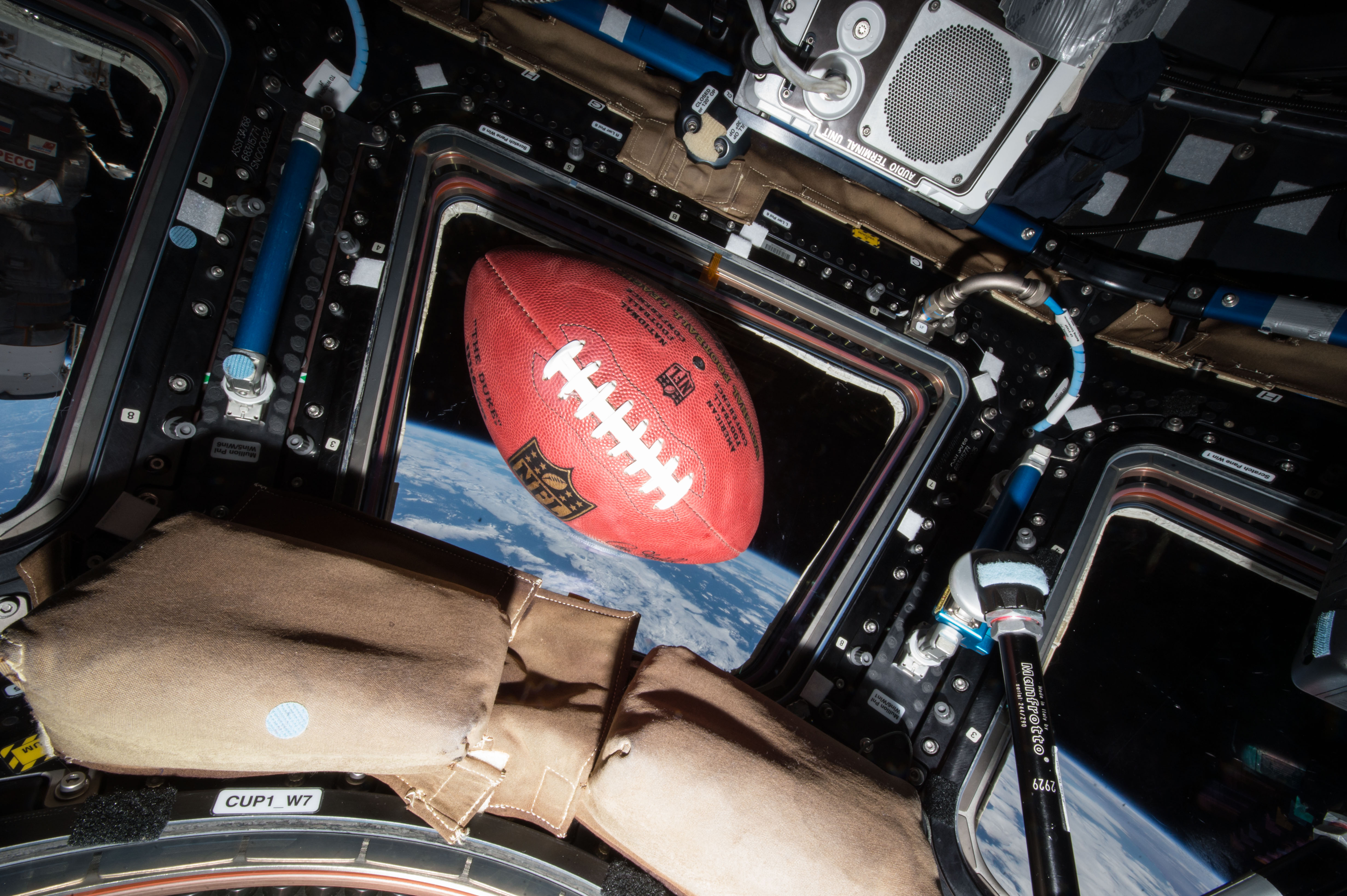
A football floats in microgravity aboard the International Space Station, high above the Earth.
Credit: NASA
Through a new collaboration between NASA and the National Football League (NFL), the agency will soon bring America’s strengths in space exploration and aeronautics innovation to the football field.
NASA will conduct flyovers, astronaut appearances, and fan engagement at NFL games across the United States as part of its new Inspiration Tour.
“This is the first season NASA is taking part in flyovers at NFL games, bringing the excitement of America’s space program directly to fans across the country,” said NASA Administrator Jared Isaacman. “We’re returning to the Moon, building a Moon Base, advancing fission-powered spacecraft, and pushing the boundaries in aeronautics, science, and discovery. Achieving those ambitions will take the very best of America, and partnering with the NFL gives us an incredible platform to inspire the next generation to look up and imagine the possibilities.”
NASA participation is targeted for the following games. Additional details will be released prior to each game, and more dates may be added:
1 p.m., Sunday, Sept. 13: Pittsburgh Steelers vs. Atlanta Falcons in Pittsburgh
1 p.m., Sunday, Sept. 20: Baltimore Ravens vs. New Orleans Saints in Baltimore
1 p.m., Sunday, Oct. 4: Philadelphia Eagles vs. Los Angeles Rams in Philadelphia
1 p.m., Sunday, Oct. 11: New York Jets vs. Cleveland Browns in East Rutherford, New Jersey
Flyovers scheduled at some of the games will showcase NASA’s fleet of aircraft, which are used for high-speed testing, high-altitude research, astronaut training, and more. Regularly flying the aircraft maintains the health of the fleet and publicly demonstrates new technologies that may be applied to future commercial air travel.
With stops across the nation and led by Isaacman, NASA’s Inspiration Tour convenes academic, industry, and public sector stakeholders to connect the agency with the people, technologies, and organizations that drive American leadership in space.
The tour will culminate in MAX POWER, a public exposition of American air and space innovation, Nov. 7 and Nov. 8, on and near the agency’s Kennedy Space Center in Florida. Held in honor of America’s historic 250th anniversary, the multi-day, family-friendly event will showcase the next-generation aircraft, spacecraft, autonomous vehicles, and technologies that will help define the future of transportation in air and space.
For more information about MAX POWER and the agency’s missions, visit:

 Login