The European Space Agency is moving "full steam ahead" with development of a robotic mission to Venus after NASA officials determined they were unlikely to fulfill a commitment to provide a US-built radar instrument for the spacecraft, the mission's project scientist said.
The European orbiter, named Envision, will map the Venusian surface at 10 times higher resolution than the last radar mission sent to Venus by NASA in the 1990s. The planet is enshrouded in a blanket of thick clouds of sulfuric acid, rendering its mysterious surface unseen by optical cameras in orbit. Radar is the most effective way to penetrate the clouds of Venus to reveal the terrain below, and scientists will use Envision to look for signs of active volcanism.
NASA and ESA signed a memorandum of understanding in 2024 outlining their partnership on Envision. NASA agreed to supply a US-made synthetic aperture radar instrument, Envision's primary means of mapping the surface of Venus, along with providing tracking and communications support through NASA's Deep Space Network. In exchange, ESA would include US researchers on Envision's science team. Europe would build the Envision spacecraft and the rest of its science instruments and provide the launch on an Ariane 6 rocket.
How 2 US, European Satellites Are Studying Hurricanes During El Niño
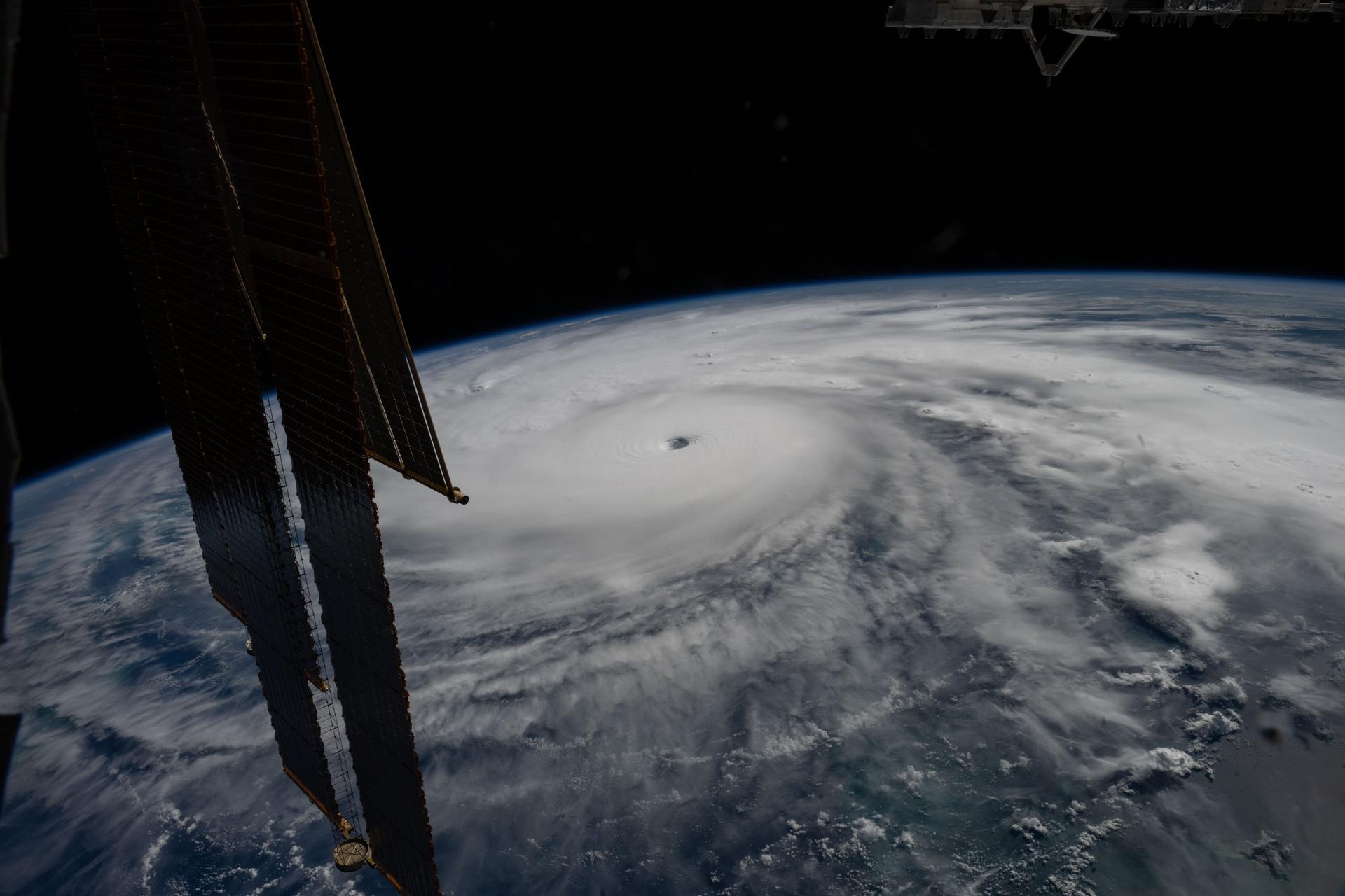
Hurricane Melissa is seen 50 miles south of Jamaica in this photograph taken from the International Space Station on Oct. 28, 2025.
NASA
Last November, NASA and its European partners launched the Sentinel-6B satellite to improve hurricane forecasts, help protect infrastructure, and benefit commercial industries, including shipping. The satellite now is flying 30 seconds behind its predecessor, Sentinel-6 Michael Freilich. Both satellites are providing precise sea level height measurements during what oceanographers expect to be a historic El Niño, a naturally occurring oceanic phenomenon in which warmer-than-usual Pacific waters shift global weather patterns.
The two satellites make up the Copernicus Sentinel-6/Jason-CS (Continuity of Service) mission, the latest in a series of ocean-observing radar altimetry missions that have been monitoring Earth’s changing seas continuously since the early 1990s.
The data each satellite is collecting will not only allow scientists to better understand this year’s El Niño but will also help them create more accurate hurricane predictions.
“This El Niño was a late-bloomer,” said Josh Willis, Sentinel-6B’s project scientist at NASA’s Jet Propulsion Laboratory in Southern California. “It didn’t kick off until the middle of the year and is just now reaching a strength similar to what we’ve seen in the satellite record during significant El Niños in 1997 and 2015. We expect it to be big, and it’s already having big impacts.”
El Niños generally scramble weather patterns tied to rainfall and storms, including hurricanes. They also redistribute heat in the ocean, which affects sea level. Normally, Earth’s warmest ocean waters sit along the equator in the western Pacific. During El Niño, weakened winds, which usually blow westward along the equator, result in heat spreading east toward South America. The change in ocean heat shifts hurricane activity from the Atlantic to the Pacific Ocean.
Predicting hurricane strength
On July 15, Sentinel-6B began delivering low-latency data to scientists that could be used for weather predictions. That data will take some time to work its way into the research models on which meteorologists and climate scientists rely, but when it does, those improved models could save lives.
Data from Sentinel-6 satellite missions feeds into hurricane tracking algorithms used by federal and state agencies. Those predictions can activate disaster response efforts, mobilizing resources ranging from sandbag placement to National Guard activation. They also can lead to evacuation orders that require quick but well-informed decisions about logistics at a local level. More severe events may require engaging larger organizations, such as the Federal Emergency Management Agency.
A tropical storm can take a week or more to become a hurricane and make its way to a coastline, but a hurricane can rapidly intensify in the 48 hours prior to landfall, leaving planners little time to prepare.
“Hurricanes have been known to speed up quickly at the last moment, so the window in which to decide what to do is short,” said Deirdre Byrne, an oceanographer and altimetry expert with the National Oceanic and Atmospheric Administration (NOAA). “The goal is to forecast how much and how rapidly intensification will happen so that officials can make the right calls.”
Each Sentinel-6 satellite measures ocean height, as well as the size of waves and marine wind speed, using a radar altimeter, which bounces thousands of radar pulses a second off the crests and troughs of waves. Ocean height varies from place to place and provides insight into the ocean’s heat content, since warm water expands. That, in turn, helps forecast how fast hurricanes will grow.
Among the measurements Sentinel-6 is gathering, Byrne is most anticipating the ocean height data, which she plans to begin incorporating into the current Satellite Ocean Heat Content Suite algorithm by the end of the year.
“In terms of data quality, the Sentinel-6 missions are unparalleled,” Byrne said.
Together, the missions are also extending a precise dataset deep into its fourth decade. This record of sea level observations traces back to the TOPEX/Poseidon mission, which launched in 1992, and continues through to the present day with Sentinel-6 Michael Freilich. Sentinel-6B will take over for its predecessor as the reference satellite for global sea level measurements later this year.
“The key is consistency, measuring the same way, every time,” said Severine Fournier, Sentinel-6B deputy project scientist, JPL. “That’s what lets us predict hurricanes, and, in turn, protect coastal communities and infrastructure.”
More about Sentinel-6B
Sentinel-6 Michael Freilich, named after a former director of NASA’s Earth Science Division, is one of two satellites that compose the Copernicus Sentinel-6/Jason-CS mission.
Sentinel-6/Jason-CS, a part of the European Union’s Earth observation program called Copernicus, was jointly developed by ESA (European Space Agency), EUMETSAT (European Organisation for the Exploitation of Meteorological Satellites), NASA, and NOAA, with funding support from the European Commission and technical support on performance from the French space agency CNES (Centre National d’Études Spatiales). Spacecraft monitoring and control, as well as the processing of all the altimeter science data, is carried out by EUMETSAT on behalf of the European Union’s Copernicus Programme, with the support of all partner agencies.
NASA JPL, a division of Caltech in Pasadena, contributed three science instruments for each Sentinel-6 satellite: the Advanced Microwave Radiometer, the GNSS-RO, and the Laser Retroreflector Array. NASA also contributed launch services, ground systems supporting operation of the agency’s science instruments, the science data processors for two of these instruments, and support for the United States members of the international Ocean Surface Topography Science Team.
Preparations for Next Moonwalk Simulations Underway (and Underwater)
Hurricane Melissa is seen 50 miles south of Jamaica in this photograph taken from the International Space Station on Oct. 28, 2025.
NASA
Last November, NASA and its European partners launched the Sentinel-6B satellite to improve hurricane forecasts, help protect infrastructure, and benefit commercial industries, including shipping. The satellite now is flying 30 seconds behind its predecessor, Sentinel-6 Michael Freilich. Both satellites are providing precise sea level height measurements during what oceanographers expect to be a historic El Niño, a naturally occurring oceanic phenomenon in which warmer-than-usual Pacific waters shift global weather patterns.
The two satellites make up the Copernicus Sentinel-6/Jason-CS (Continuity of Service) mission, the latest in a series of ocean-observing radar altimetry missions that have been monitoring Earth’s changing seas continuously since the early 1990s.
The data each satellite is collecting will not only allow scientists to better understand this year’s El Niño but will also help them create more accurate hurricane predictions.
“This El Niño was a late-bloomer,” said Josh Willis, Sentinel-6B’s project scientist at NASA’s Jet Propulsion Laboratory in Southern California. “It didn’t kick off until the middle of the year and is just now reaching a strength similar to what we’ve seen in the satellite record during significant El Niños in 1997 and 2015. We expect it to be big, and it’s already having big impacts.”
El Niños generally scramble weather patterns tied to rainfall and storms, including hurricanes. They also redistribute heat in the ocean, which affects sea level. Normally, Earth’s warmest ocean waters sit along the equator in the western Pacific. During El Niño, weakened winds, which usually blow westward along the equator, result in heat spreading east toward South America. The change in ocean heat shifts hurricane activity from the Atlantic to the Pacific Ocean.
Predicting hurricane strength
On July 15, Sentinel-6B began delivering low-latency data to scientists that could be used for weather predictions. That data will take some time to work its way into the research models on which meteorologists and climate scientists rely, but when it does, those improved models could save lives.
Data from Sentinel-6 satellite missions feeds into hurricane tracking algorithms used by federal and state agencies. Those predictions can activate disaster response efforts, mobilizing resources ranging from sandbag placement to National Guard activation. They also can lead to evacuation orders that require quick but well-informed decisions about logistics at a local level. More severe events may require engaging larger organizations, such as the Federal Emergency Management Agency.
A tropical storm can take a week or more to become a hurricane and make its way to a coastline, but a hurricane can rapidly intensify in the 48 hours prior to landfall, leaving planners little time to prepare.
“Hurricanes have been known to speed up quickly at the last moment, so the window in which to decide what to do is short,” said Deirdre Byrne, an oceanographer and altimetry expert with the National Oceanic and Atmospheric Administration (NOAA). “The goal is to forecast how much and how rapidly intensification will happen so that officials can make the right calls.”
Each Sentinel-6 satellite measures ocean height, as well as the size of waves and marine wind speed, using a radar altimeter, which bounces thousands of radar pulses a second off the crests and troughs of waves. Ocean height varies from place to place and provides insight into the ocean’s heat content, since warm water expands. That, in turn, helps forecast how fast hurricanes will grow.
Among the measurements Sentinel-6 is gathering, Byrne is most anticipating the ocean height data, which she plans to begin incorporating into the current Satellite Ocean Heat Content Suite algorithm by the end of the year.
“In terms of data quality, the Sentinel-6 missions are unparalleled,” Byrne said.
Together, the missions are also extending a precise dataset deep into its fourth decade. This record of sea level observations traces back to the TOPEX/Poseidon mission, which launched in 1992, and continues through to the present day with Sentinel-6 Michael Freilich. Sentinel-6B will take over for its predecessor as the reference satellite for global sea level measurements later this year.
“The key is consistency, measuring the same way, every time,” said Severine Fournier, Sentinel-6B deputy project scientist, JPL. “That’s what lets us predict hurricanes, and, in turn, protect coastal communities and infrastructure.”
More about Sentinel-6B
Sentinel-6 Michael Freilich, named after a former director of NASA’s Earth Science Division, is one of two satellites that compose the Copernicus Sentinel-6/Jason-CS mission.
Sentinel-6/Jason-CS, a part of the European Union’s Earth observation program called Copernicus, was jointly developed by ESA (European Space Agency), EUMETSAT (European Organisation for the Exploitation of Meteorological Satellites), NASA, and NOAA, with funding support from the European Commission and technical support on performance from the French space agency CNES (Centre National d’Études Spatiales). Spacecraft monitoring and control, as well as the processing of all the altimeter science data, is carried out by EUMETSAT on behalf of the European Union’s Copernicus Programme, with the support of all partner agencies.
NASA JPL, a division of Caltech in Pasadena, contributed three science instruments for each Sentinel-6 satellite: the Advanced Microwave Radiometer, the GNSS-RO, and the Laser Retroreflector Array. NASA also contributed launch services, ground systems supporting operation of the agency’s science instruments, the science data processors for two of these instruments, and support for the United States members of the international Ocean Surface Topography Science Team.
Dr. Delia Santiago-Materese wants things to get complex
From terrestrial animals to experiments in microgravity and Martian clouds, this NASA program scientist’s career path links diverse challenges. Today, she supports a mission to Saturn’s moon Titan, a world teeming with organic molecules that could hold valuable clues about the origin of life.
When novelty is your hobby, you already have a large part of the recipe for a career full of challenges. That is why Dr. Delia Santiago-Materese describes her path within NASA as “meandering.” Her diverse roles have taken her to low Earth orbit, to the clouds of Mars, and to the surroundings of Jupiter. Now, they are also bringing her closer to the surface of Titan, an intriguing moon of Saturn. Woven together by her exploring spirit and a perennial curiosity, all these experiences have one point in common: life.
Today, Santiago-Materese is part of the Planetary Science Division at NASA Headquarters in Washington. The main decoration in her office is a model of Jupiter, larger than a basketball, resting next to a scale model of the spacecraft exploring it, Juno. Small black and red pins with the inscription “Dragonfly” rest in the center of a round table. Several framed diplomas cover a wall. From here, Santiago-Materese does “a little bit of everything” on any given workday as a program scientist for the Juno and Dragonfly missions, and for the Discovery program, which features a portfolio of several missions in our cosmic neighborhood.
This medley of roles is no coincidence. Santiago-Materese describes herself as someone who does not pursue a single goal, but rather diverse interests that she discovers along the way. “I am always looking for something new to add to my experiences,” she says, “because I think I also get bored easily.”
Santiago-Materese holds her model of Jupiter, just outside her office. As a program scientist for Juno—a mission studying this planet—for Dragonfly, and for the Discovery program, she guides these projects by promoting leadership based on kindness and respect: “Every person brings something unique.”
NASA/Noelia González
The daughter of a military family, Santiago-Materese was born in Spain by coincidence. Her roots are actually on another continent: her mother is Mexican-American and her father is Puerto Rican. From her time in Spain, she only keeps some baby photos; she lived part of her life in Texas and then in California, which she considers her home—despite having spent her childhood summers in San Sebastián, Puerto Rico. It was in the Golden State where she first imagined herself as a veterinarian and decided to study Biological Sciences. And it was during her studies at Stanford University, “just around the corner” from NASA’s Ames Research Center in California’s Silicon Valley, that Santiago-Materese discovered astrobiology.
This elective course brought her closer to a discipline that, to some extent, was in its infancy. Today, NASA’s Astrobiology Program investigates life in the universe on many levels: how it began, how it evolved here on Earth, and where it might exist elsewhere. And that was how Santiago-Materese realized that biology and space were not two isolated things, she recounts.
Rodents, Insects, and Martian Clouds
After finishing her studies, Santiago-Materese completed a one-year internship at the San Francisco Zoo. But the unknown that astrobiology presents continued to intrigue her, so she went back to one of her professors to inquire more about it. She asked around and found someone at Lockheed Martin, a company that often contracts with NASA on space projects. They were looking for people for a new project studying the nutrition of the food bars for rodents traveling to space aboard the space shuttle.
Santiago-Materese has applied that formula ever since: identifying what truly interests her and finding the right person to ask questions. If people “don’t know what you’re interested in, they can’t help you,” she explains. After experience with the Space Shuttle Program, including managing databases for science payloads aboard the space shuttle, she went on to work with the International Space Station, which was then beginning its legacy of over 25 years in Earth orbit. She supported the development of biological experiments in microgravity, this time with fruit flies. But Santiago-Materese wanted to keep moving farther from Earth and investigate future space destinations.
This curiosity led her to the Martian sky. As part of her graduate studies at the University of California, Santa Cruz, Santiago-Materese investigated the Martian atmosphere, focusing on ice in the clouds and the development of climate models for the Red Planet. She earned her master’s degree and would later return to complete her doctorate under the NASA Pathways program, which is one of the agency’s primary early-career hiring pathways. She would defend her thesis six months after giving birth to her first daughter (one of the achievements she is most proud of, she says). That is why, although she loves the “weird” planets of the outer solar system, she is “more of a Mars person,” by training.
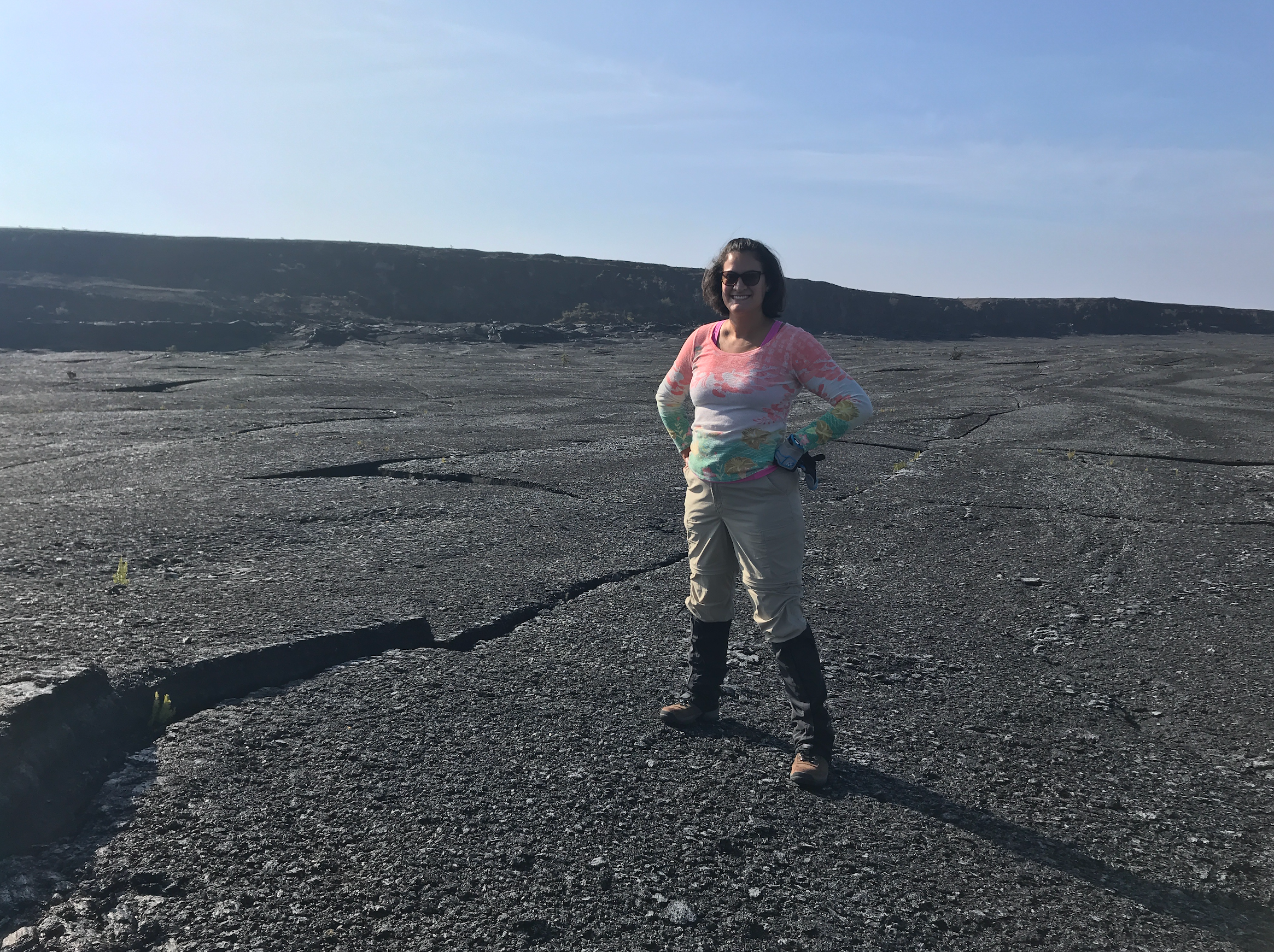
During her NASA career, Santiago-Materese traveled to Hawaii to investigate a planetary analog, a type of terrestrial environment that has very similar characteristics to those we might find on other worlds.
Image credit: Delia Santiago-Materese
At NASA Ames, Santiago-Materese held various roles, ranging from social media and open science to lunar sciences. She then became a program officer for the Solar System Workings program in the Planetary Science Division at NASA Headquarters as part of a detail, or temporary assignment. And then, she took off for Maryland along with her family.
Enabling Science
Santiago-Materese sums up her current role as a program scientist as the “science liaison” between NASA Headquarters and a mission. “When you do program scientist work, you might not be specialized or an expert in the exact science, but you need to be able to understand it and talk about it, to understand its importance,” she explains. “In general, we are supporting other people so they can do science.” In this endeavor, being someone who “gets more energy from working with people” is useful… and necessary: “You are having conversations all day long” with colleagues from different disciplines— from science and engineering to finance.
The Juno mission, in orbit around Jupiter since 2016, and Dragonfly, which is scheduled to launch no earlier than July 2028, are part of NASA’s New Frontiers program. Santiago-Materese also oversees the array of missions in the Discovery program, which includes ongoing science missions like Psyche and Lucy—heading to different asteroids—and future missions to Venus.
For Santiago-Materese, sharing her unconventional path can be valuable for students and youth in general, especially those who are unsure of what they want to do. “Your dream job,” she says, “you might not know it exists, or maybe it doesn’t exist today.” Beyond that, this zigzagging path has led her to accumulate experiences and relationships with different people, which she treasures even as she sets off for her next destination.
An Alien World
About two years out from Dragonfly’s launch, it is no surprise that this robotic mission takes up much of Santiago-Materese’s time. “Dragonfly feels like a combination of all my different experiences over time,” she reflects. And it signifies, to some extent, a return to her roots: it is an astrobiology mission. Although not designed to detect life, Dragonfly will investigate prebiotic chemistry: the chemical processes that could have led to the emergence of life on Earth.
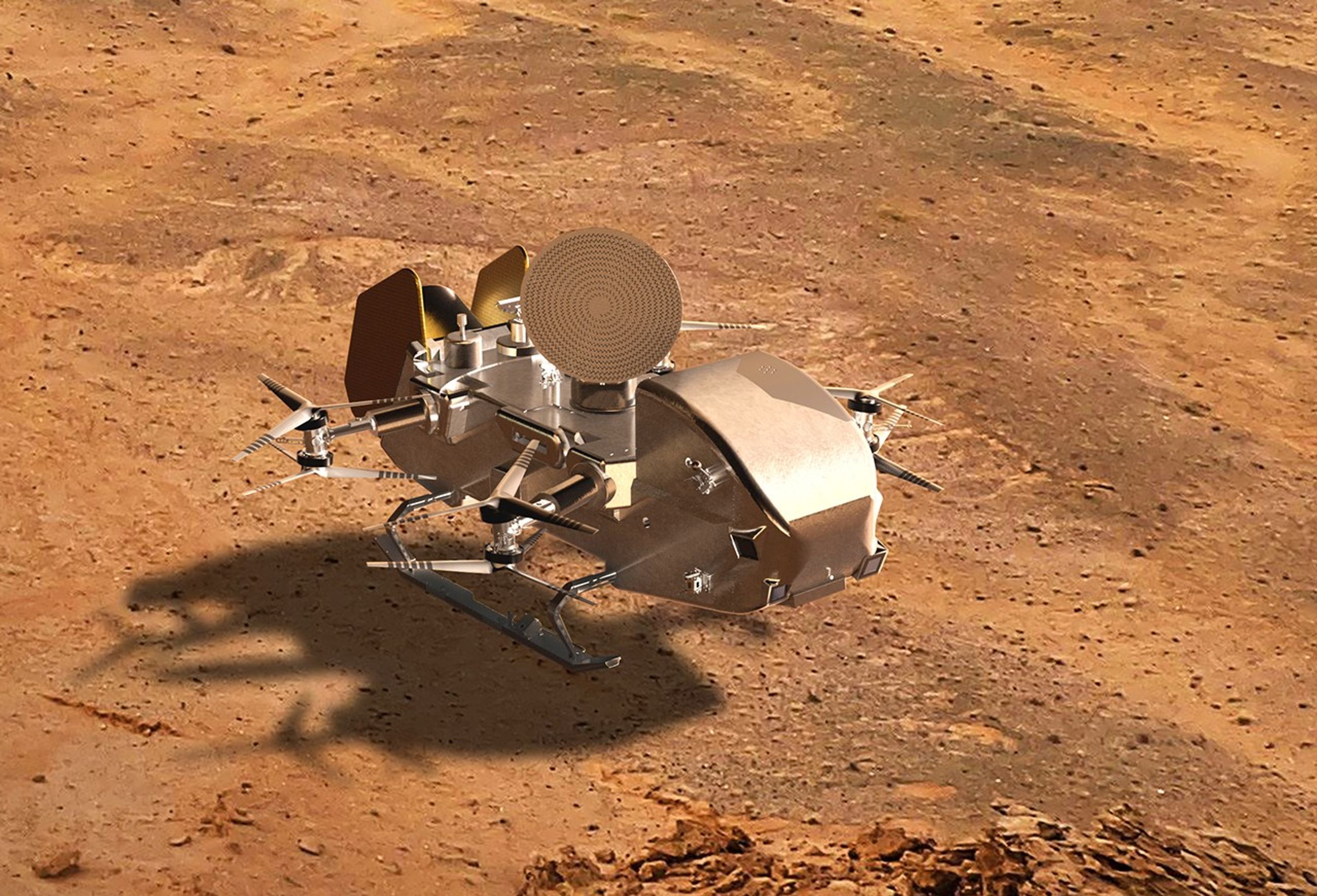
Digital concept of NASA’s Dragonfly lander on the surface of Saturn’s moon Titan.
NASA/Johns Hopkins APL/Steve Gribben
Dragonfly will embark on a journey of about six years to the surface of Titan. The spacecraft will carry an array of science instruments and will be the first NASA science mission to explore another world by flying from location to location. This car-sized rotorcraft will touch down at various geological sites of interest to analyze the moon’s composition and its habitability potential.
When it arrives at Titan, it will encounter a landscape that is strange and familiar at the same time: it could be a window into Earth’s remote past. This frozen world has a thick atmosphere and clouds drifting across the sky; dunes, lakes, rivers, canyons and mountains. Titan even has a process equivalent to our water cycle. However, on Titan, it is not water that flows but hydrocarbons, primarily methane and ethane. “It’s a more methane-based chemistry, so it is very alien, and that is what I really love about Titan,” says Santiago-Materese. And on this moon, organic molecules abound.
These molecules contain carbon and are used by all known forms of life. They are fundamental to understanding the origin of life, as they can be produced by both biological and non-biological processes. On Titan, these organic molecules fall to the surface and form dense deposits over its bedrock of water ice. Scientists believe that the complex chemistry precursor to life could be triggered there if provided with a little liquid water, such as that generated by an asteroid impact.
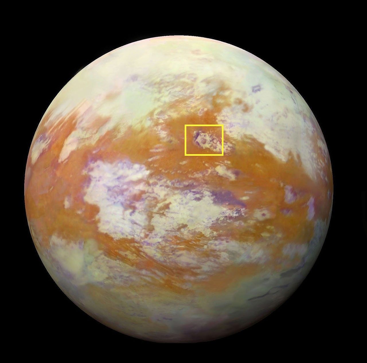
Selk Crater, an 80-kilometer (50-mile) diameter impact site highlighted in this infrared image of Titan, is a key destination for Dragonfly. The rotorcraft will touch down near Selk and explore various sites, analyzing the surface chemistry to investigate the frozen remains of what could have been prebiotic chemistry in development.
NASA/JPL-Caltech/University of Nantes/University of Arizona
Santiago-Materese is especially excited about what the Dragonfly Mass Spectrometer (DraMS) instrument will help discover. DraMS, designed and built at NASA’s Goddard Space Flight Center in Greenbelt, Maryland, will analyze samples from Titan’s surface. “The more complex things get, the more interesting things happen,” she says. “So I’m curious: just how complex do the molecules get? Will we find any interesting patterns?”
But in science, every time you ask a question, a new one arises. Dragonfly will try to answer several of them. “When you have a planet with complex chemistry but not life, what happens? What is there before life?” the program scientist wonders.
Titan, a valuable natural laboratory, “is going to completely change our understanding of what another world can be like,” she anticipates. In addition to what the scientific community expects to discover thanks to Dragonfly, Santiago-Materese is interested in the potential unexpected findings. “There are very defined science goals, but a lot of it is exploratory work,” she explains. “It is kind of nice to know that there is a big range [of possibilities], that we could be very surprised.”
By Noelia González, NASA’s Goddard Space Flight Center, Greenbelt, Maryland
Machine vision is becoming a practical part of Apple’s U.S. factory training strategy, giving smaller manufacturers access to techniques that help production systems inspect what they make. The recent opening of the Houston manufacturing training center extends that effort into a working electronics production campus, while courses developed with Michigan State University introduce businesses to image analysis, machine learning, and automated quality checks.
For a manufacturer, the attraction can be straightforward: finding a missing component before a product leaves the line, identifying a surface defect before more material is added, or recognizing an assembly error while it can still be corrected cheaply.
These are manageable problems with measurable costs. They also offer an accessible starting point for businesses interested in AI but unsure where it belongs inside their operations.
Machine Vision Enters the Manufacturing Curriculum
The Apple Manufacturing Academy’s current course catalog includes Machine Learning with Vision, a course introducing machine learning and deep learning through practical activities using Apple devices. It sits alongside instruction in automation, quality fundamentals, manufacturing data, maintenance, and process improvement.
That placement gives the subject useful context. A camera can produce an image, but a factory needs a decision: accept the part, flag it for review, check its position, or investigate a process that may be drifting out of tolerance.
Machine vision connects image capture to those operational decisions. Some applications use established rules to measure dimensions or identify patterns. Others use machine learning to recognize acceptable variations and defects that are difficult to describe through fixed rules.
The academy’s public description confirms introductory activities with Apple devices. It does not identify a particular iPhone, Mac configuration, software framework, or industrial camera package that every participant must use.
For smaller businesses, the educational value is learning how to define an inspection problem before purchasing equipment. A company that understands what it needs to detect can have a much more productive conversation with an automation supplier.
Houston Brings Training Closer to Production
Apple opened its 20,000-square-foot Advanced Manufacturing Center on August 13. According to the Houston opening announcement, the free program offers small and medium-sized businesses instruction in advanced manufacturing, interactive labs, and experience with representative production equipment.
The first cohort worked with machine learning for quality control and advanced automation. Participants also explored production challenges, used a holographic table, and assembled and laser etched a product.
The location adds context: the center occupies the same Houston facility that builds advanced AI servers and is scheduled to begin Mac mini manufacturing this year. Its teaching program includes final assembly principles and design considerations for printed circuit board assembly.
Houston is the company’s second U.S. manufacturing learning site, following the Detroit academy established with Michigan State University in August 2025. By the Houston opening, Apple said the academy had helped nearly 1,000 workers, students, and entrepreneurs.
That figure measures people reached through the program. It should not be interpreted as 1,000 factories already operating AI inspection systems.
Apple Machine Learning Adapters
A Useful Inspection Starts With a Specific Problem
Imagine a small business assembling control panels. Each panel needs the same set of connectors, positioned correctly before the enclosure closes. A machine vision station could check for a missing connector while the assembly remains accessible.
The value comes from catching that error at the right moment. Discovering it after packaging creates extra handling and rework. Discovering it after delivery may involve a return, a service visit, and an unhappy customer.
A useful pilot would therefore begin with that single inspection point. The business could compare the existing process with the assisted one, recording missed defects, unnecessary rechecks, inspection time, and the cost of correcting mistakes.
The camera is only part of the exercise. Workers must agree on what constitutes a defect, collect representative examples, and decide what happens when the result is uncertain.
Those decisions draw heavily on experience already present on the factory floor. An operator may know that an unusual mark is harmless, while a barely visible change in alignment predicts a later assembly problem. Turning that knowledge into consistent inspection criteria is valuable work in its own right.
These are examples of how manufacturers could apply the training, rather than projects Apple has announced for individual participants.
Teaching Machine Vision to Handle Ordinary Variation
A demonstration can look impressive when every part arrives clean, centered, and evenly lit. Production introduces variation: different surface finishes, reflections, changing positions, and batches that look slightly different while remaining within specification.
The inspection system must distinguish those acceptable differences from actual failures. Otherwise, it can reject good products or allow defective ones to continue.
Industrial vision supplier Cognex’s deployment guidance recommends validating systems across product models, defect types, and manufacturing lines. It also describes an approach in which automated inspection handles preliminary checks while experienced inspectors review borderline cases.
For a business learning machine vision, that offers a realistic way to introduce the technology. Employees can compare its decisions with their own, investigate disagreements, and determine whether the results justify extending its role.
An inspection system also needs an owner after installation. Someone must understand when a product change requires new examples, when equipment needs attention, and when performance has slipped. Training that responsibility into the workforce helps prevent an initially successful project from becoming an unreliable fixture.
Smaller Manufacturers Are Already Applying the Training
The academy’s reach extends beyond companies producing consumer electronics. In its May update on participating manufacturers, Apple highlighted Block Imaging, a Michigan business that services and refurbishes medical imaging equipment.
The company hosted visitors during the academy’s Spring Forum and described applying techniques learned from Apple engineers and Michigan State experts to its operations. Apple reported that the academy had supported more than 150 American businesses at that point.
The announcement did not identify a particular machine vision deployment at Block Imaging or publish a percentage improvement attributable to visual inspection. It does provide an example of the training reaching businesses whose work differs substantially from building an iPhone.
That wider participation could benefit Apple indirectly. More capable domestic manufacturers can support equipment maintenance, tooling, components, and specialized production services. Participation itself does not establish a supplier relationship, but the skills can be used across customers and industries.
Access Without a Large Training Budget
The academy’s participation information says eligible small and medium-sized U.S. manufacturers can take courses free of charge. Online learning includes on-demand materials and interactive modules, while in-person sessions add workshops and more personalized instruction.
Digital badges are available for different topics, and completed course materials remain accessible for review. That gives a business room to train an employee around existing production commitments and return to the material when an actual project begins.
Free instruction does not remove the eventual cost of cameras, lighting, integration, maintenance, or employee time. It can help a manufacturer understand those costs before committing to a system.
The first proposal brought back to the factory might be modest: inspect one recurring defect at one station and record the results for several weeks. A supervisor can then weigh the time saved against the extra reviews, maintenance, and mistakes. That is the kind of evidence a business owner can use when deciding whether to install a second station.
According to a new paper published this week in the Proceedings of the National Academy of Sciences, some of the smallest bees studied have photoreceptors as sharp as those of much larger honeybee drones.
For the first time in decades, NASA has rolled out one of its iconic astronaut training aircraft with a bold, new look.
The space agency debuted a new livery on one of its T-38 jets in celebration of its program to return astronauts to the Moon. The Artemis design retains nods to what made the "white rocket" immediately recognizable, but adds a new colorway and painted graphics to make clear where NASA is headed.
"This new 'Artemis' livery has a black and white paint scheme with blue and red stripes that separate those two paint schemes," said Sean Brady, who proposed and designed the new livery while serving as the T-38 project pilot in NASA's Aircraft Operations Division (AOD), part of the Flight Operations Directorate at Johnson Space Center in Houston. "The Artemis program logo in the back and a picture of the Moon is on the left and right side of the rear fuselage."
Charlotte Henry and Chuck Joiner catch up after a brief break to discuss the first looks at Silo Season 4, Neuromancer, and the return of Ted Lasso. The issue of adaptation versus original storytelling, speculation on Apple TV strategy are debated from the new leadership perspective. The hosts also share their expectations for upcoming releases. […]
A resource for checking Mac external-display support, Comcast’s move away from NBCUniversal, Peacock’s streaming and sports strategy, and whether broadband offers a stronger business model than media all started off this MacVoices Live! conversation. Chuck Joiner, David Ginsburg, Brian Flanigan-Arthurs, Ben Roethig, Eric Bolden, Marty Jencius, Jeff Gamet, Norbert Frassa, Jim Rea, and Web Bixby examine Apple Invites and question why so many Apple features launch with fanfare but receive little sustained development.
Charlotte Henry and Chuck Joiner examine Apple TV’s strategy through the expansion of Monarch: Legacy of Monsters, the theatrical release of Tenzing, and Eddie Cue’s Cannes Lions recognition. They compare Apple’s stated quality-over-quantity approach with Netflix’s engagement-first model, then consider F1 sequel plans and speculate on what smart glasses could mean for the streaming service from […]
Charlotte Henry and Chuck Joiner explore how Apple TV connects sports, entertainment, and corporate strategy, from World Cup coverage and the After the Whistle podcast to Slow Horses and global storytelling. They debate Tim Cook’s visible Hollywood presence, his role in the service’s growth, and how future leadership could shape Apple’s streaming ambitions.
The MacVoices Live! panel examines backlash around Apple rumor reporting, especially Vision Pro speculation and the impact of click-driven headlines on developers and readers. Chuck Joiner, David Ginsburg, Marty Jencius, Eric Bolden, Brian Flanigan-Arthurs, Jeff Gamet and Mark Fuccio then turn to Bartender’s return after past trust concerns, alternatives for menu bar management, and whether […]
Charlotte Henry and Chuck Joiner discuss Apple TV’s sports and awards momentum, from Lionel Messi’s expanding U.S. profile and Friday Night Baseball visibility to major BAFTA and Tony recognition. They also examine how awards influence viewer choices, upcoming Apple TV projects with John Travolta and James Marsden, and frustrations with subtitle handling in multilingual shows.
The MacVoices Live! panel discuss privacy, AI, and digital trust, comparing Meta’s Instagram encryption rollback with Apple’s RCS encryption in Messages. Chuck Joiner, David Ginsburg, Eric Bolden, Brian Flanigan-Arthurs, Marty Jencius, and Jeff Gamet also examine an AI lawsuit involving a chatbot posing as a doctor, plus AI customer service, Apple Wallet, and user trust in technology.
The MacVoices Live! panel examine Apple’s quarterly earnings, the continuing importance of Services revenue, and what John Ternus’ presence on Apple’s earnings call may indicate about Apple’s future leadership transition. Chuck Joiner, David Ginsburg, Eric Bolden, Brian Flanigan-Arthurs, Marty Jencius, and Jeff Gamet discuss the Apple Vision Pro and the newest wave of “Vision Pro is doomed” commentary. They argue that Vision Pro should be viewed as an early-stage platform product that still needs more time, more content, more developer support, and a larger installed base before its long-term value can be fairly judged.
The fully-integrated LEMS (Lunar Environment Monitoring Station) ready for environmental testing. A small suitcase-size instrument suite built at NASA Goddard, LEMS is designed to carry out continuous, long-term monitoring of the seismic environment at the Moon, including surface motion caused by moonquakes and meteorite impacts in the lunar south polar region.
NASA Goddard/Mike Guinto
NASA has declared “wrenches down” on the first completed payload designed for Artemis astronauts to deploy on the Moon’s surface. Engineers working on NASA’s Lunar Environment Monitoring Station, or LEMS, have completed hardware development and testing and the payload is ready for its permanent home near the lunar South Pole. With the hardware complete, LEMS is ready to support one of the Artemis program’s core goals: enabling sustained lunar science and exploration.
The LEMS instrument package contains two highly sensitive seismometers that will monitor ground vibrations from moonquakes and meteorite impacts, providing scientists with insights into the Moon’s interior and the seismic hazards astronauts might encounter at the surface. Its modular design allows the system to be adapted or expanded to host new instruments in the future, creating a reusable platform that can evolve as scientific priorities grow.
The payload will remain in a clean room at NASA’s Goddard Space Flight Center in Greenbelt, Maryland, where it was built, until it is assigned to an Artemis mission for deployment to the lunar surface.
“The completion of the LEMS scientific instrument is a major step in a new era of lunar surface science. Innovative science experiments will uncover, measure, and reveal the Moon’s secrets while astronauts open new frontiers for discovery,” said Joel Kearns, deputy associate administrator for exploration, Science Mission Directorate, NASA Headquarters in Washington. “And, behind the scenes, countless teams across NASA and our partners are pushing the boundaries of what surface instruments can do, building the tools that will make future exploration possible and safer.”
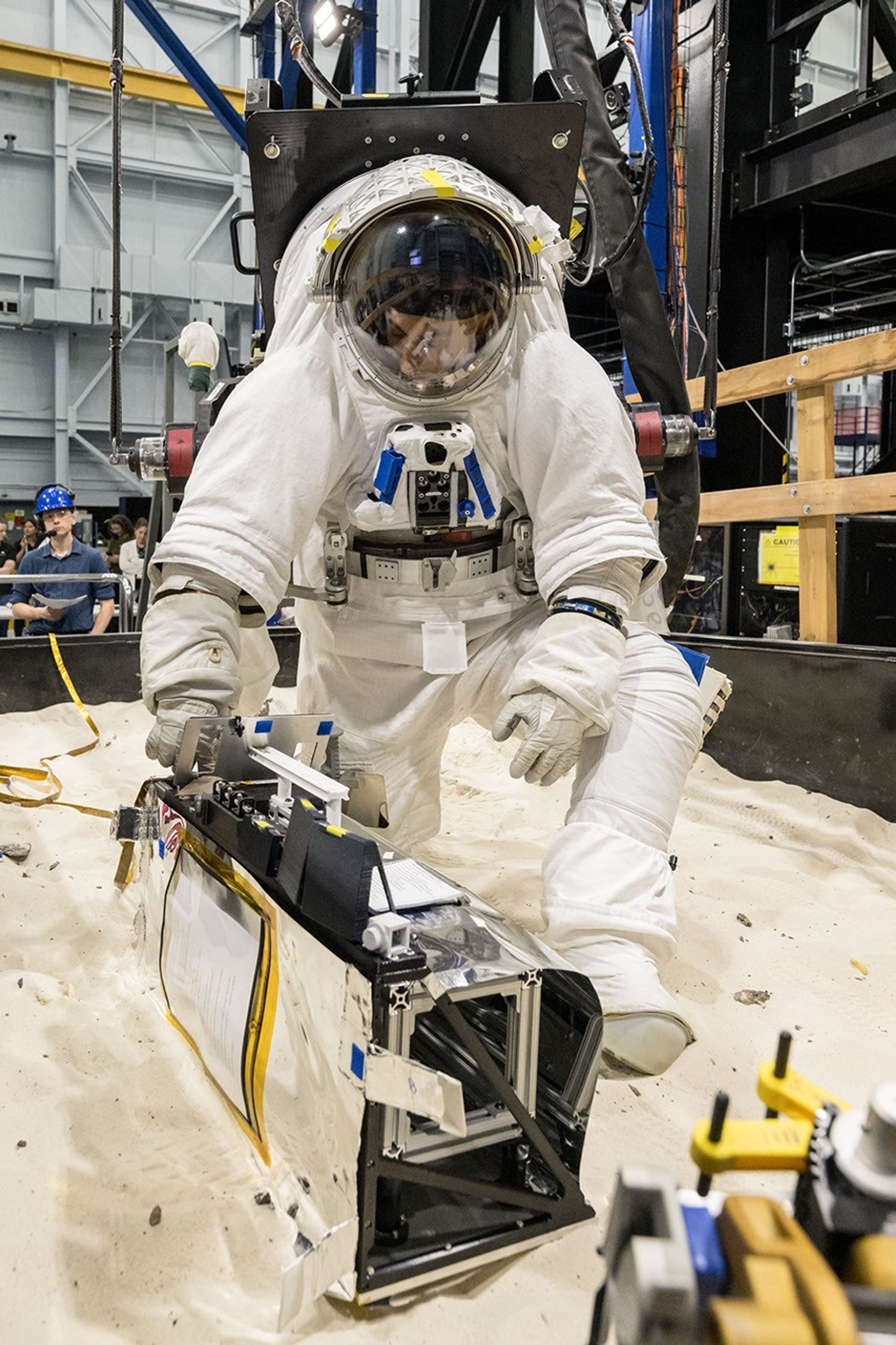
A scientist wearing NASA’s xEMU prototype space suit is testing the handling of a mockup version of NASA’s Lunar Environment Monitoring Station, or LEMS. The testing took place at the Active Response Gravity Offload System, a simulated reduced gravity environment at NASA’s Johnson Space Center in Houston.
NASA Johnson
The LEMS payload builds on a legacy of lunar seismic tracking. Apollo astronauts deployed a network of seismometers on the Moon’s nearside equatorial region between 1969 and 1972. Those instruments operated until 1977, recording about 13,000 moonquakes and other ground vibrations that helped scientists begin to understand the composition of the Moon’s interior. For decades, researchers have hoped to spread more seismometers, updated with new technologies, across the lunar surface.
Now, LEMS will carry the first seismometers to be deployed by future astronauts to listen for faint ground vibrations, collecting new clues to the Moon’s internal structure and ongoing seismic activity. The sensors will be the most compact, sensitive, and energy-efficient seismometers ever built for planetary exploration.
LEMS itself is about the size of a small suitcase, weighing 11 pounds in the Moon’s low-gravity environment. It will carry not just these seismic sensors, but everything it needs to function independently of humans after deployment. LEMS is built to manage its own power production via a lightweight, flexible solar array that conforms to the shape of the LEMS unit. It also will manage its operational activities to ensure continuous data collection based on a preset plan, and monthly data transmission to Earth. The payload will do all this while maintaining a stable internal temperature throughout the massive day-to-night temperature swings of the South Pole region.
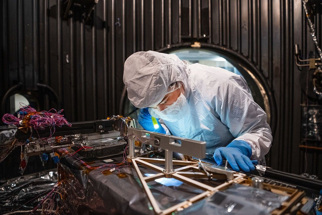
Mechanical Engineer Brie Ludwig inspects the Lunar Environment Monitoring Station (LEMS) in preparation for testing in a thermal vacuum chamber at Goddard Space Flight Center in Greenbelt, Maryland, on March 31, 2026. LEMS is a compact, autonomous, and self-sustaining seismometer suite designed to carry out continuous, long-term monitoring of the lunar seismic environment at the South Polar region.
NASA/Denny Henry
“When we conceived of LEMS, we weren’t just thinking about the next mission, we were thinking about the next generation of lunar exploration,” said Mehdi Benna, a University of Maryland Baltimore County scientist who leads LEMS from NASA Goddard. “Our vision was to create a scientific buoy for the Moon. Like an ocean buoy on Earth, LEMS is designed to be easy to build, adaptable to different scientific objectives, and capable of operating independently for years.”
Before any surface science could happen, Benna and his team had to ensure that LEMS could survive the trip to the Moon and the harsh environment of its surface. Over the past five months, LEMS and its components have been subjected to a demanding series of environmental and operational tests. Engineers verified LEMS can endure the violent shaking of launch, the journey to the lunar surface, and the Moon’s temperature and radiation environment. The team also showed that the instrument package’s mechanical and electrical design is safe for astronaut handling.
The LEMS payload was built to operate through the lunar night, which lasts two Earth weeks, without external power assistance or a heat source. Past lunar surface instruments relied on radioisotope heaters for warmth and power. But LEMS instead will withstand temperatures that dip to minus 400 degrees Fahrenheit in some areas by using advanced insulation materials, low-thermal-conductivity cables that minimize heat loss, and a thermal regulator that conducts heat away during the day to prevent overheating and helps retain heat at night.
These innovations reduce mass and power needs, setting the stage for lighter, energy-efficient instruments that can operate continuously at future Artemis landing sites and the NASA-led Moon Base.
The LEMS payload is led by University of Maryland Baltimore County and University of Maryland College Park. Technical implementation is led by NASA Goddard. The University of Arizona, in partnership with Silicon Audio, Inc., supplied LEMS’ two state-of-the-art seismometers. Morehead State University in Kentucky provided LEMS’ telecommunication system and will operate the instrument on the surface. Washington University in St. Louis will manage the instrument’s data processing and dissemination to the larger scientific community.
 Login