❌

Reading view

How 2 US, European Satellites Are Studying Hurricanes During El Niño

5 min read

Preparations for Next Moonwalk Simulations Underway (and Underwater)
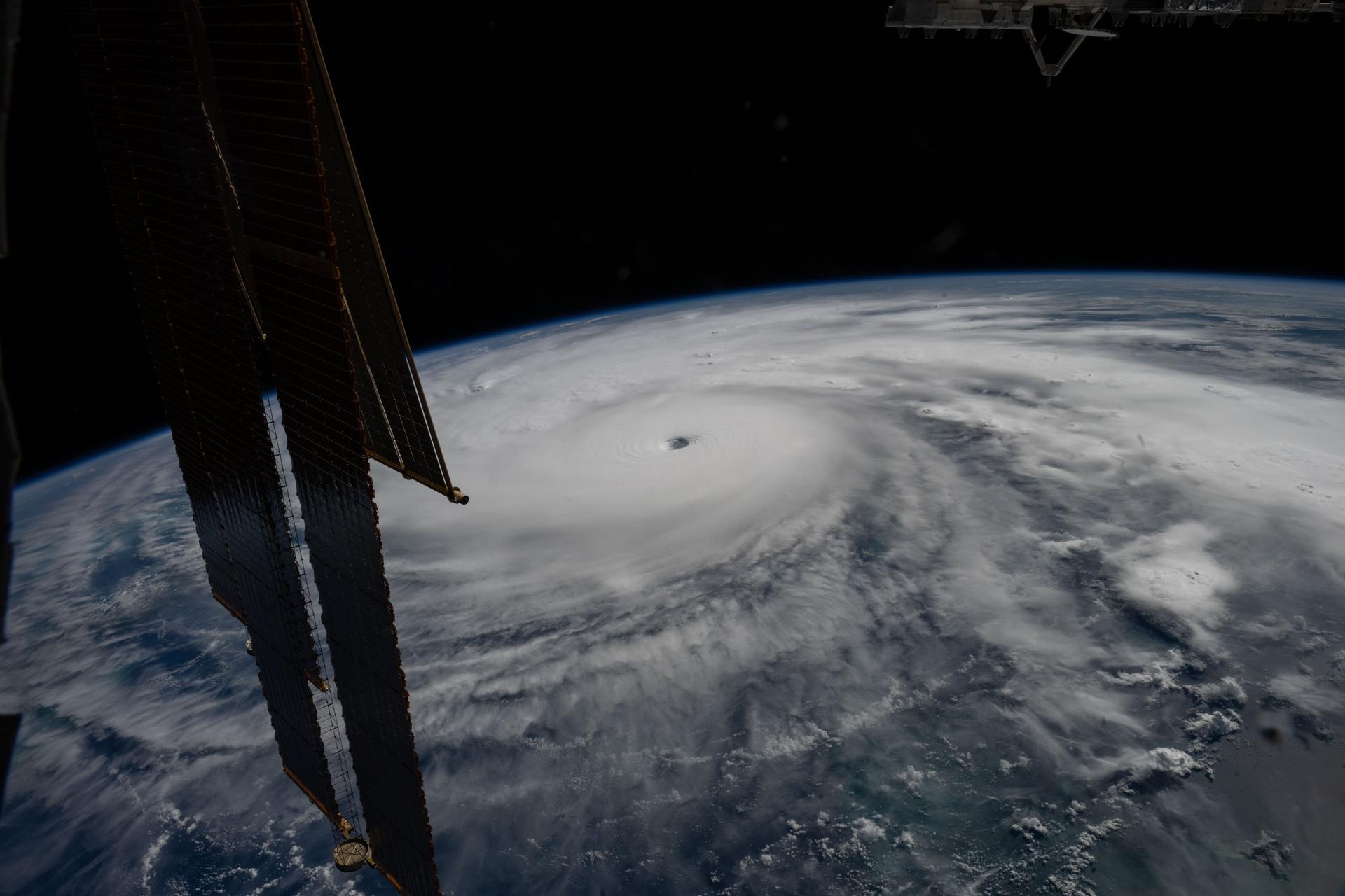
Category 5 Hurricane Melissa, one of the most powerful storms to strike the Caribbean in recent history, is pictured about 50 miles south of Jamaica in this photograph from the International Space Station as it orbited 262 miles above the Yucatan Peninsula.
Hurricane Melissa is seen 50 miles south of Jamaica in this photograph taken from the International Space Station on Oct. 28, 2025.
NASA

Last November, NASA and its European partners launched the Sentinel-6B satellite to improve hurricane forecasts, help protect infrastructure, and benefit commercial industries, including shipping. The satellite now is flying 30 seconds behind its predecessor, Sentinel-6 Michael Freilich. Both satellites are providing precise sea level height measurements during what oceanographers expect to be a historic El Niño, a naturally occurring oceanic phenomenon in which warmer-than-usual Pacific waters shift global weather patterns.

The two satellites make up the Copernicus Sentinel-6/Jason-CS (Continuity of Service) mission, the latest in a series of ocean-observing radar altimetry missions that have been monitoring Earth’s changing seas continuously since the early 1990s.

The data each satellite is collecting will not only allow scientists to better understand this year’s El Niño but will also help them create more accurate hurricane predictions.

“This El Niño was a late-bloomer,” said Josh Willis, Sentinel-6B’s project scientist at NASA’s Jet Propulsion Laboratory in Southern California. “It didn’t kick off until the middle of the year and is just now reaching a strength similar to what we’ve seen in the satellite record during significant El Niños in 1997 and 2015. We expect it to be big, and it’s already having big impacts.”

El Niños generally scramble weather patterns tied to rainfall and storms, including hurricanes. They also redistribute heat in the ocean, which affects sea level. Normally, Earth’s warmest ocean waters sit along the equator in the western Pacific. During El Niño, weakened winds, which usually blow westward along the equator, result in heat spreading east toward South America. The change in ocean heat shifts hurricane activity from the Atlantic to the Pacific Ocean.

Predicting hurricane strength

On July 15, Sentinel-6B began delivering low-latency data to scientists that could be used for weather predictions. That data will take some time to work its way into the research models on which meteorologists and climate scientists rely, but when it does, those improved models could save lives.

Data from Sentinel-6 satellite missions feeds into hurricane tracking algorithms used by federal and state agencies. Those predictions can activate disaster response efforts, mobilizing resources ranging from sandbag placement to National Guard activation. They also can lead to evacuation orders that require quick but well-informed decisions about logistics at a local level. More severe events may require engaging larger organizations, such as the Federal Emergency Management Agency.

A tropical storm can take a week or more to become a hurricane and make its way to a coastline, but a hurricane can rapidly intensify in the 48 hours prior to landfall, leaving planners little time to prepare.

“Hurricanes have been known to speed up quickly at the last moment, so the window in which to decide what to do is short,” said Deirdre Byrne, an oceanographer and altimetry expert with the National Oceanic and Atmospheric Administration (NOAA). “The goal is to forecast how much and how rapidly intensification will happen so that officials can make the right calls.”

Byrne oversees one of the country’s most crucial hurricane forecasting algorithms, NOAA’s Satellite Ocean Heat Content Suite, which has been operating since 2012.

Each Sentinel-6 satellite measures ocean height, as well as the size of waves and marine wind speed, using a radar altimeter, which bounces thousands of radar pulses a second off the crests and troughs of waves. Ocean height varies from place to place and provides insight into the ocean’s heat content, since warm water expands. That, in turn, helps forecast how fast hurricanes will grow.

The satellites each carry a second instrument, called the Global Navigation Satellite System – Radio Occultation (GNSS-RO), which measures atmospheric properties, such as humidity, pressure, and temperature.

Among the measurements Sentinel-6 is gathering, Byrne is most anticipating the ocean height data, which she plans to begin incorporating into the current Satellite Ocean Heat Content Suite algorithm by the end of the year.

“In terms of data quality, the Sentinel-6 missions are unparalleled,” Byrne said.

Together, the missions are also extending a precise dataset deep into its fourth decade. This record of sea level observations traces back to the TOPEX/Poseidon mission, which launched in 1992, and continues through to the present day with Sentinel-6 Michael Freilich. Sentinel-6B will take over for its predecessor as the reference satellite for global sea level measurements later this year.

“The key is consistency, measuring the same way, every time,” said Severine Fournier, Sentinel-6B deputy project scientist, JPL. “That’s what lets us predict hurricanes, and, in turn, protect coastal communities and infrastructure.”

More about Sentinel-6B

Sentinel-6 Michael Freilich, named after a former director of NASA’s Earth Science Division, is one of two satellites that compose the Copernicus Sentinel-6/Jason-CS mission.

Sentinel-6/Jason-CS, a part of the European Union’s Earth observation program called Copernicus, was jointly developed by ESA (European Space Agency), EUMETSAT (European Organisation for the Exploitation of Meteorological Satellites), NASA, and NOAA, with funding support from the European Commission and technical support on performance from the French space agency CNES (Centre National d’Études Spatiales). Spacecraft monitoring and control, as well as the processing of all the altimeter science data, is carried out by EUMETSAT on behalf of the European Union’s Copernicus Programme, with the support of all partner agencies.

NASA JPL, a division of Caltech in Pasadena, contributed three science instruments for each Sentinel-6 satellite: the Advanced Microwave Radiometer, the GNSS-RO, and the Laser Retroreflector Array. NASA also contributed launch services, ground systems supporting operation of the agency’s science instruments, the science data processors for two of these instruments, and support for the United States members of the international Ocean Surface Topography Science Team.

For more about Sentinel-6B, visit:

https://science.nasa.gov/mission/sentinel-6B

-end-

Media Contacts

Andrew Good / Andrew Wang
Jet Propulsion Laboratory, Pasadena, Calif.
818-393-2433 / 626-379-6874
andrew.c.good@jpl.nasa.gov / andrew.wang@jpl.nasa.gov

2026-060

  •  

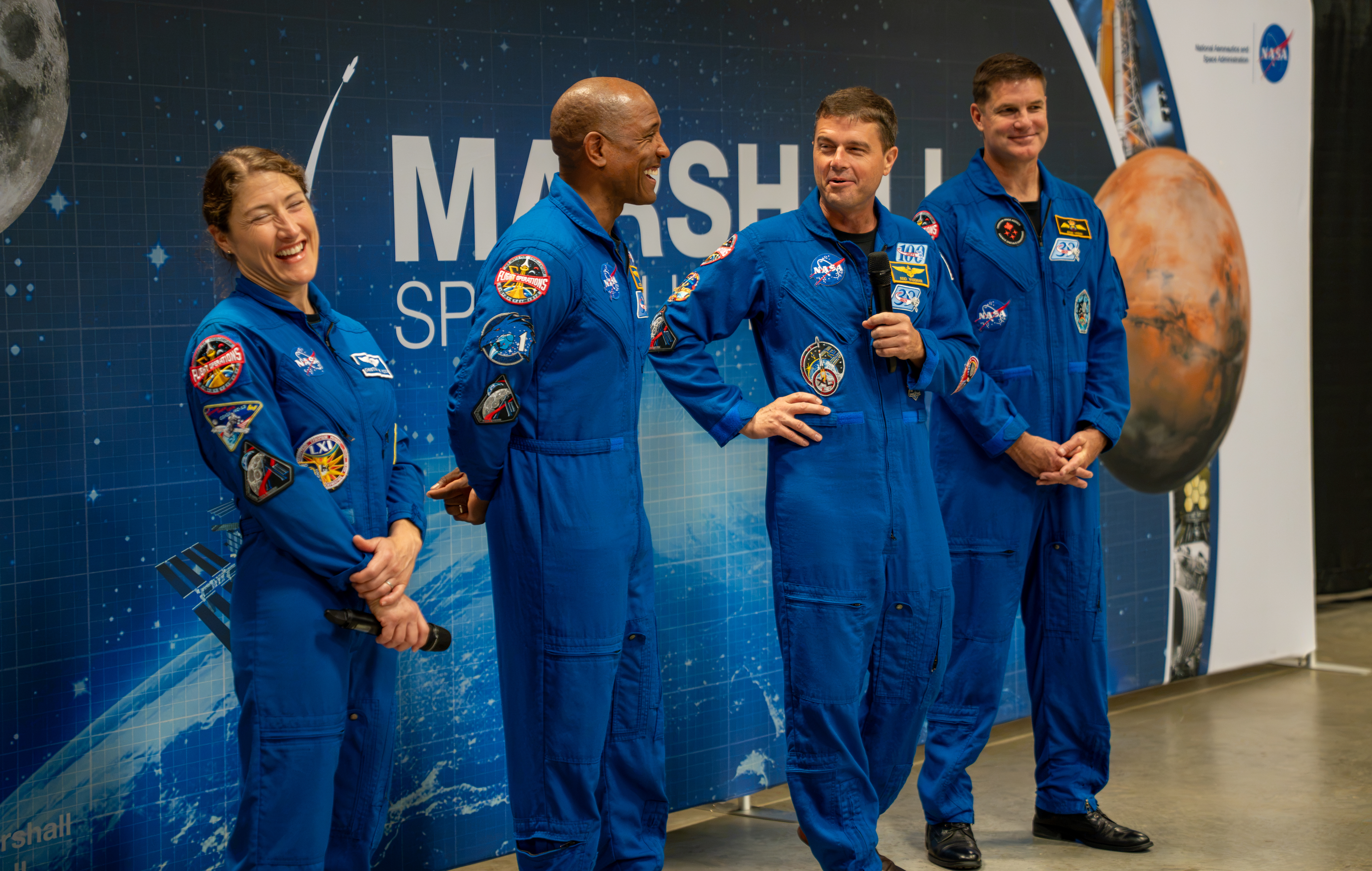
Artemis II Crew at NASA Marshall

The Artemis II crew smile and laugh. They are wearing blue jumpsuits with patches on them. Christina Koch, left, and Reid Wiseman, second from right, are holding microphones.
NASA/Brandon Hancock

The crew of NASA’s Artemis II mission – NASA astronauts Christina Koch, Victor Glover, and Reid Wiseman and CSA (Canadian Space Agency) astronaut Jeremy Hansen – visited Huntsville, Alabama, Sept. 1, 2026, where they met with the NASA workforce at NASA’s Marshall Space Flight Center. The event gave the crew an opportunity to share firsthand experiences from their mission, reflect on their time in space, and connect with the workforce that supported the mission through an engaging question-and-answer session.

Image credit: NASA/Brandon Hancock

  •  

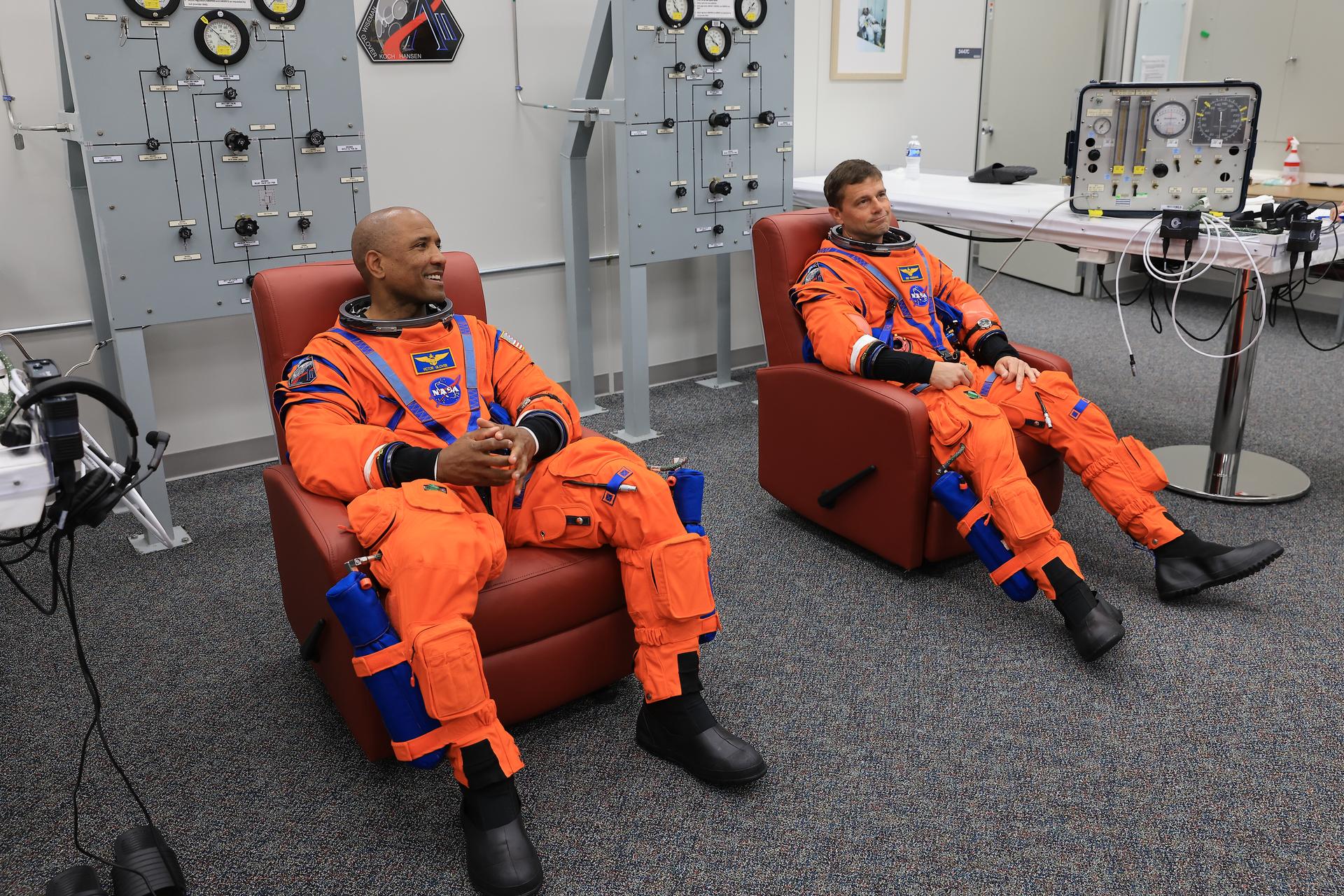
NASA Names Two Artemis II Astronauts to Emeritus Program

From left, NASA astronauts Victor Glover, Artemis II pilot and Reid Wiseman, Artemis II commander, are seated in chairs wearing orange jumpsuits. Behind them are two large gray panels with dials. The two astronauts are listening attentively and they prepare to conduct leak checks on his spacesuit inside the crew suit-up room in the Neil A. Armstrong Operations and Checkout Building at the agency’s Kennedy Space Center in Florida on Wednesday, April 1, 2026, ahead of the Artemis II test flight.
From left, NASA astronauts Victor Glover, Artemis II pilot, and Reid Wiseman, Artemis II commander, conduct leak checks on their spacesuits inside the crew suit-up room in the Neil A. Armstrong Operations and Checkout Building at the agency’s Kennedy Space Center in Florida on Wednesday, April 1, 2026, ahead of the Artemis II test flight.
Credit: NASA/Kim Shiflett

Following their landmark Artemis II mission earlier this year, distinguished NASA astronauts Victor Glover and Reid Wiseman are transitioning in September to emeritus status at the agency’s Johnson Space Center in Houston.

In an emeritus role, individuals with a high degree of technical and professional knowledge can continue to support the agency by donating their time to train and mentor the current workforce. This allows the agency to maintain access to top talent in a specialized consultant role, while simultaneously providing the individual with the flexibility to pursue other opportunities.

“I’ve had the privilege of knowing Reid and Victor for years, and both exemplify the leadership, character, and commitment that define NASA at its best.” said NASA Administrator Jared Isaacman. “Reid commanded Artemis II after previously spending 165 days aboard the International Space Station, while Victor brought his experience as a naval aviator, test pilot, and Crew-1 astronaut to his role as pilot. Together, they took on one of the most challenging missions in human spaceflight and helped return America to the lunar environment. As Reid and Victor transition to emeritus status, I’m grateful they will continue sharing what they learned with our astronauts, flight controllers, and engineers as we prepare for Artemis III in 2027 and the missions that follow.”

Glover will support aerospace, leadership, and public service efforts as he transitions within and outside of NASA. He’s committed to transferring his knowledge of Orion and its spacecraft systems, among other expertise, to future Artemis missions.

“As I grow into this new role, NASA and spaceflight remain a meaningful part of my journey of service,” said Glover. “I’m excited to keep uplifting my friends and cheering them on as they reach for the Moon. Together, we’ll keep pushing boundaries and inspiring the next giant leap.”

Wiseman is set to share his spaceflight experience with colleagues ahead of the agency’s Artemis III mission in low Earth orbit to test rendezvous and docking capabilities between Orion and commercial human landing systems.

“There is no better place to work, and there are no better people to work with, than those in this agency,” said Wiseman. “NASA gave me tremendous responsibility, supported me through two space missions, and my time as chief astronaut, and was always there for my family when we needed it most. I’m thrilled to continue serving future missions and programs through the emeritus program.”

“Reid and Victor’s commitment to exploration, steady leadership, and service to our astronaut corps and our nation have made a lasting impact,” said Vanessa Wyche, director of NASA’s Johnson Space Center in Houston. “Throughout their careers, they have each brought excellence, humility, and purpose to every role they have held at NASA. Their contributions have helped advance our mission and inspire those around them, leaving a legacy that will continue to shape the future of human spaceflight. We are immeasurably grateful for all they have given to NASA and are glad that this is not the end of their journey with the agency.”

“Reid and Victor are trusted teammates whose professionalism, calm leadership, and unwavering commitment to NASA have strengthened our office and inspired everyone around them,” said Scott Tingle, chief of the Astronaut Office at Johnson. “As they transition into their emeritus roles, they leave a legacy of operational excellence that will continue shaping the astronaut corps for years to come. We’re grateful that they will still be part of our community, sharing their experience and insight as they begin this next chapter.”

Among their many accomplishments at NASA, as Artemis II crew members, Glover and Wiseman were two of the four astronauts to first launch on top NASA’s SLS (Space Launch System) rocket aboard the Orion spacecraft for a mission around the Moon. Following a 10-day mission with crewmates NASA astronaut Christina Koch and CSA (Canadian Space Agency) astronaut Jeremy Hansen, they safely splashed down on April 10 as the first humans to travel to lunar orbit in more than 50 years, ultimately flying farther in space than anyone had before.

Support and knowledge transfer from both Glover and Wiseman is critical for the upcoming Artemis III mission as NASA prepares to return American astronauts to the lunar surface on the Artemis IV mission in 2028.

To learn more about NASA astronauts, visit:

https://www.nasa.gov/astronauts

-end-

George Alderman / Cheryl Warner
Headquarters, Washington
202-356-1600
george.a.alderman@nasa.gov / cheryl.m.warner@nasa.gov

Share

Details

Last Updated
Sep 09, 2026
  •  

Curiosity Blog, Sols 4995-5001: 5,000 (Martian) Days on Mars

4 min read

Curiosity Blog, Sols 4995-5001: 5,000 (Martian) Days on Mars

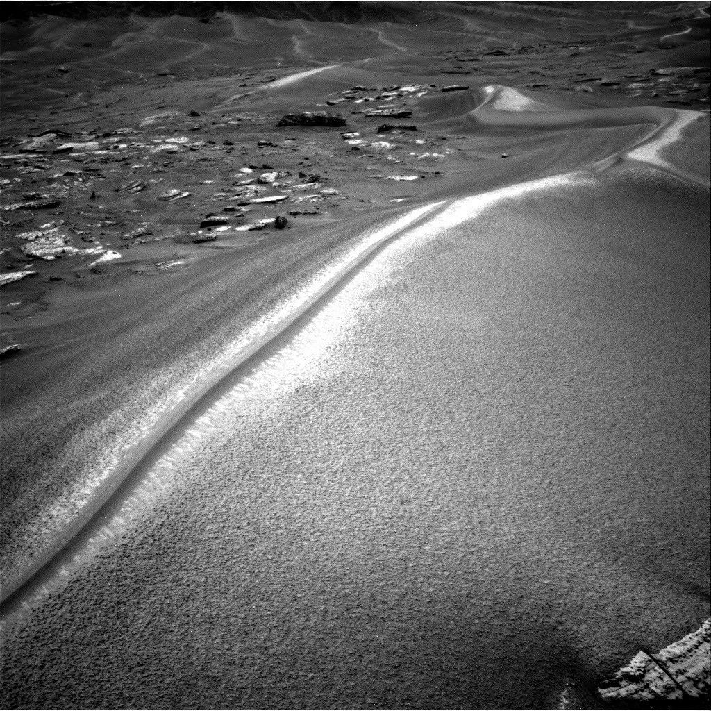
A black-and-white photograph from the Mars Curiosity rover showing a large, sweeping sand dune with a sharp, brightly sunlit crest. To the left are scattered flat rocks, and more rolling dunes stretch into the distant background.
NASA’s Mars rover Curiosity acquired this image along Chocolatal ripple using its Right Navigation Camera on Aug. 28, 2026 — Sol 4998, or Martian day 4,998 of the Mars Science Laboratory mission — at 13:58:36 UTC.
NASA/JPL-Caltech

Written by William Farrand, Senior Research Scientist, Space Science Institute

Earth planning date: Friday, Aug. 28, 2026

The span of sols spanned by this blog post is noteworthy in several ways. First, Curiosity became a world-class (for Mars at least) mountaineer by passing the 1 kilometer mark of elevation from its landing site on the floor of Gale crater. This writer was on the Mars Exploration Rover science team and we were excited when the Spirit rover got to the top of Husband Hill in Gusev crater in August 2005. But that was a climb of 106 meters (about 348 feet) above its landing site, and Curiosity has passed 1000 meters (about 0.62 miles). 

Second, Saturday, Aug. 29, marked 5,000 Martian days (or sols) since Curiosity landed on Mars (that’s more than 5,137 Earth days, because a day on Mars lasts 24.6 hours). Congratulations are in order to the engineers and scientists who have made this landmark possible. 

Finally, in terms of its science activities Curiosity is examining a wind-formed, long, narrow, large ripple which has been named “Chocolatal.” Further examination will help determine if this feature could be classified as a “transverse aeolian ridge” or TAR. TARs have been observed across the Martian surface based on orbital imaging. The long axis of a TAR is oriented perpendicular to the local predominant wind direction. While this is not the first potential TAR that has been examined by Curiosity, its location, higher on the slopes of Mount Sharp invites questions about whether it will be composed of the same types of granular materials found in the lower TARs, or whether it has a different range of grain sizes and/or layering. 

Other questions to be addressed include how the ridge formed, whether it is active, how it has migrated, and, if it is immobile, then how has it stabilized?

At the start of the planning week, Curiosity was en route to the sand ripple and encountered interesting science targets along the way. In Monday’s two-sol plan, in-situ examinations were planned of the light-toned bedrock occurring along the rover’s path. Some of the rocks encountered near the rover had dark-toned thick coatings or remnant layers, and these were targeted for chemical examination by the rover’s ChemCam Laser Induced Breakdown Spectroscopy (LIBS) instrument. Mastcam and ChemCam Remote Micro Imager (RMI) mosaics were planned, for layers in buttes along the rover’s path, and on more distant sets of sand ripples.

A midweek planning session took advantage of the last drive, leaving the rover only a few meters from Chocolatal. ChemCam was able to target sand at the base of Chocolatal as well as nearby bedrock. Stand-off Mastcam high-resolution image mosaics of the ripple were also targeted. The drive planned midweek took the rover right into Chocolatal with one of its wheels and then backing off a little, so in the end-of-week plan, contact science could be planned within the trenched region.

The final planning session of the week, which extended through the landmark Sol 5000, involved MAHLI mosaics of the right wall of the trench to see if there is layering, and to assess any variations in grain size. It’s noteworthy that these MAHLI mosaics are being named in honor of our late colleague Paul Geissler, who was one of the foremost experts on the study of Martian TARs and who was working with the MAHLI team before his untimely passing earlier in the year. In-situ APXS measurements were planned of the coarse-grained surface of the ripple, and ChemCam LIBS measurements were planned on the top of Chocolatal, a sinuous feature looking like a “mohawk” haircut (see the accompanying image). LIBS was also planned on a dark band on its flank and at the back of the scuff/trench. Other activities in the three-sol plan included Mastcam mosaics, an AM Navcam dust-devil survey, Navcam suprahorizon survey, and APXS atmospheric measurements.

With 5000 sols of outstanding scientific accomplishments, the Curiosity science and engineering team looks forward to the next 5000 sols.

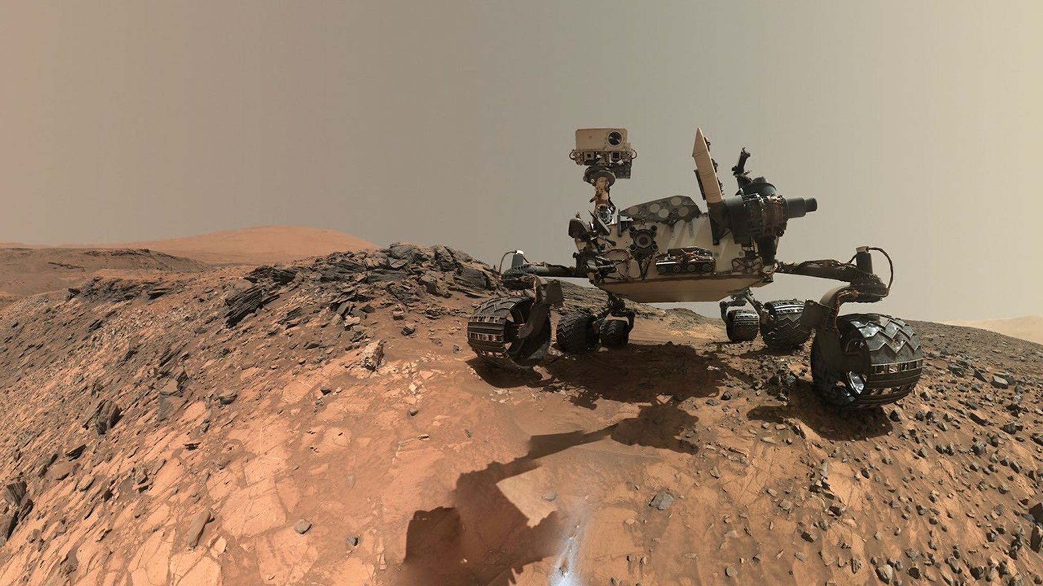
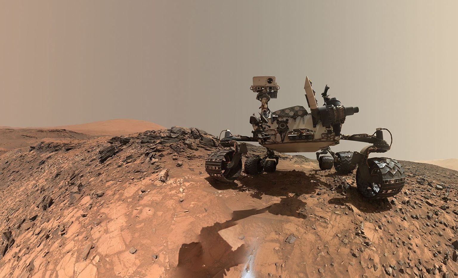
A rover sits on the hilly, orange Martian surface beneath a flat grey sky, surrounded by chunks of rock.
NASA’s Curiosity rover at the base of Mount Sharp
NASA/JPL-Caltech/MSSS

Share

Details

Last Updated
Sep 09, 2026

Related Terms

  •  

Anak Krakatau Rumbles Again

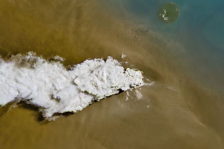
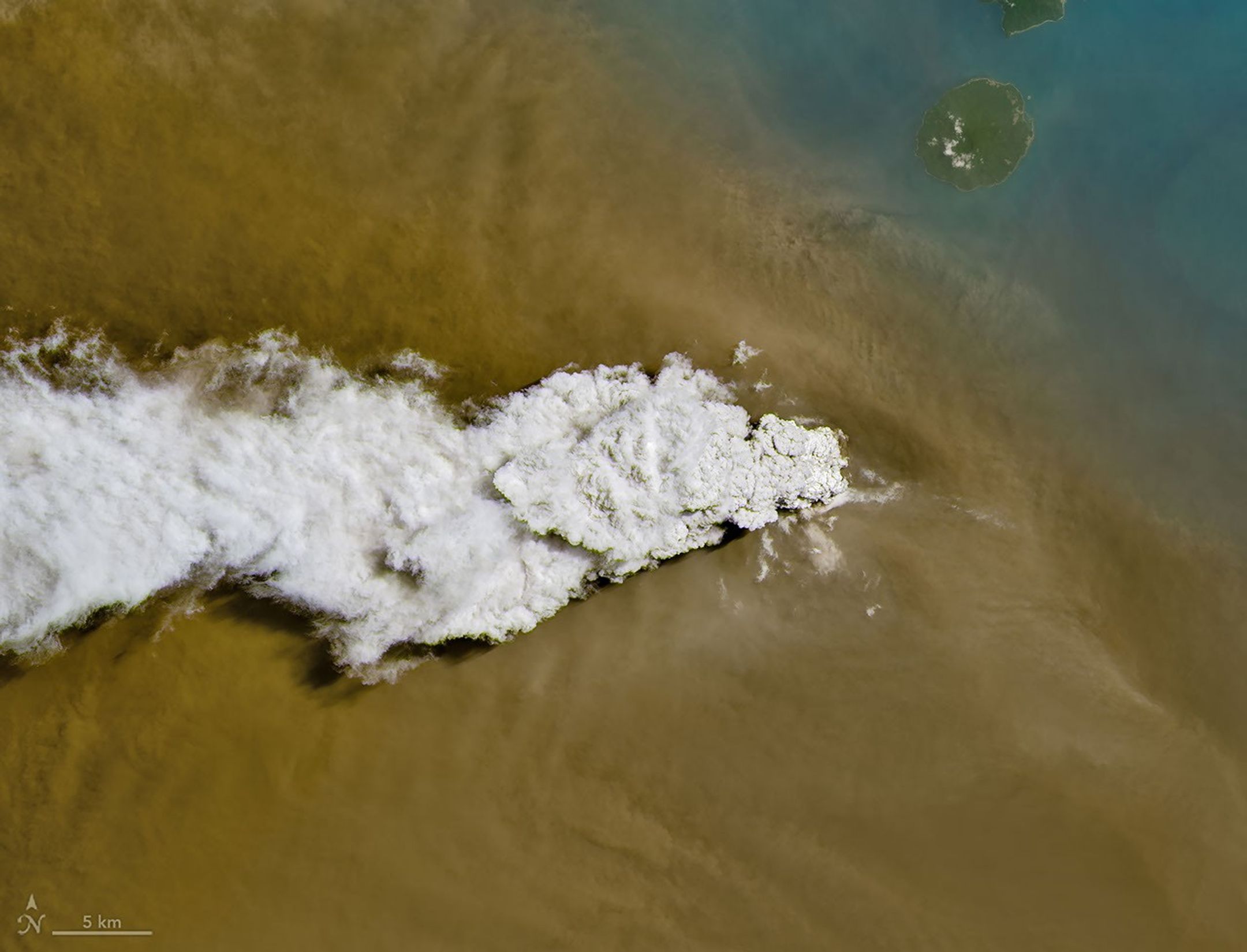
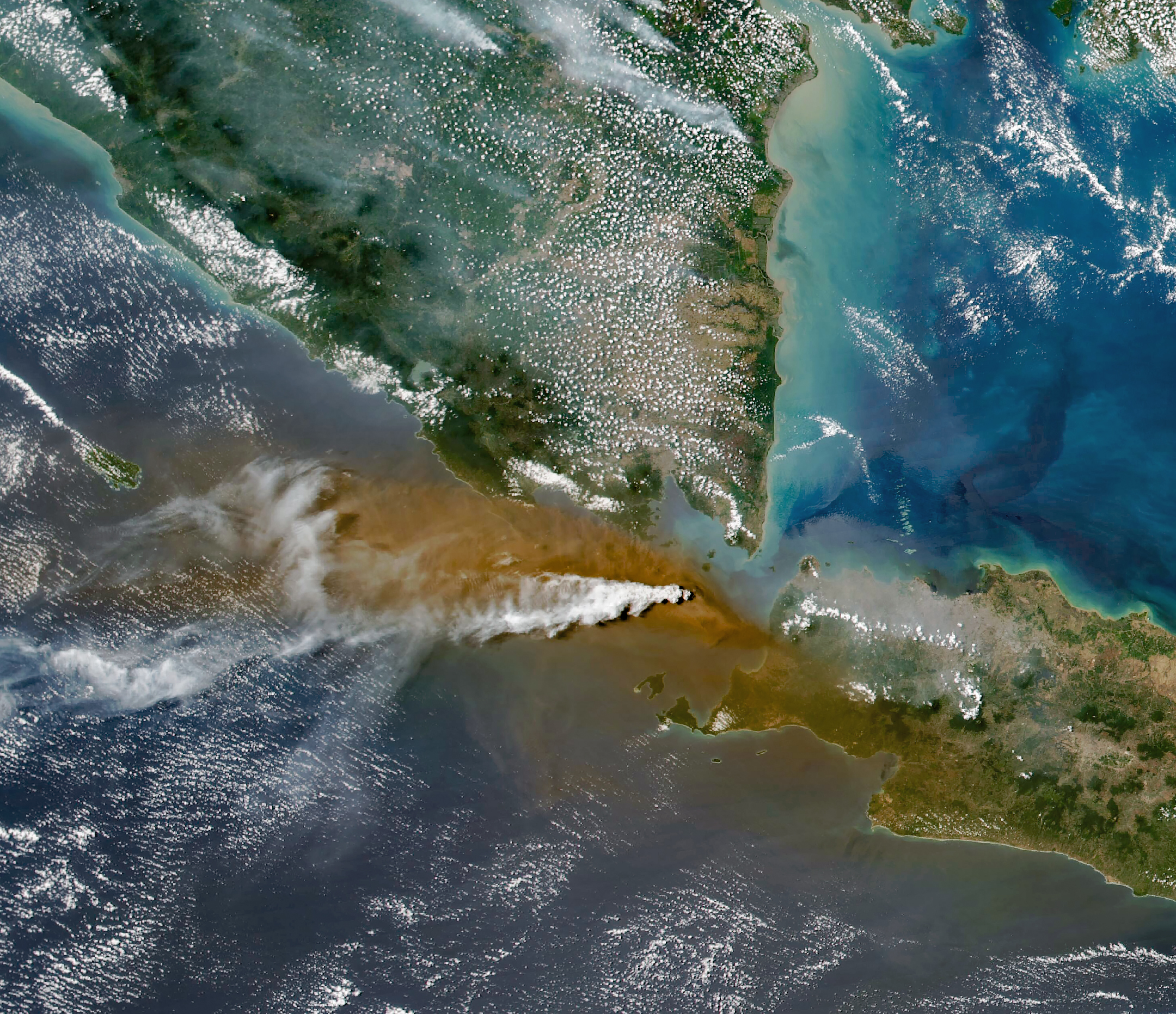
A white volcanic plume streams left over a tan ash cloud that fills most of the image. A small green island and blue water are visible in the upper right.
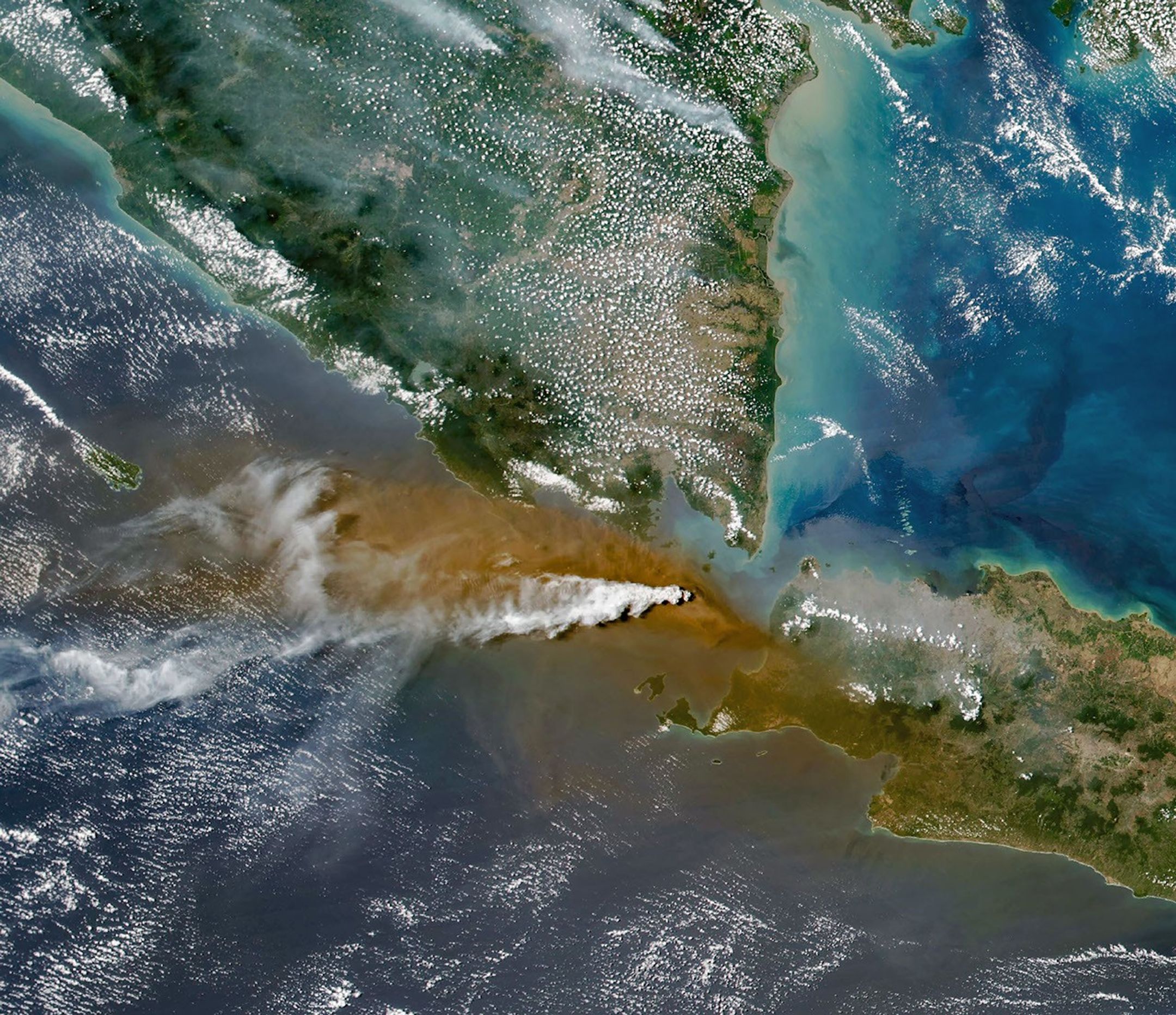
Anak Krakatau erupts ash and volcanic gases in this image acquired with the OLI (Operational Land Imager) on Landsat 8 on September 5, 2026.
NASA Earth Observatory/Michala Garrison

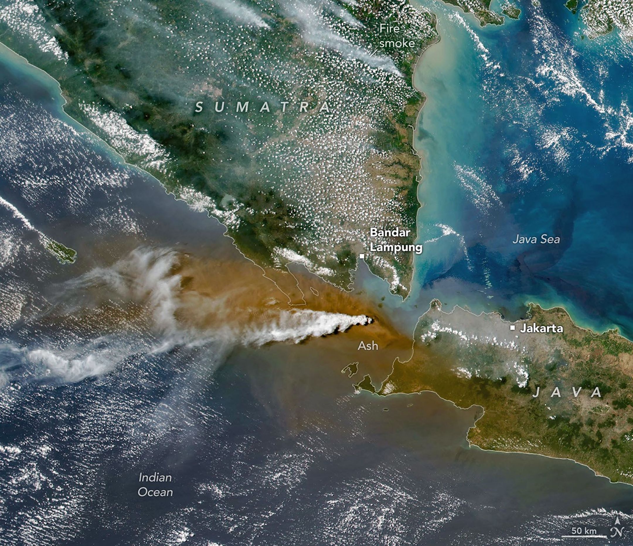
Eruptions are a regular occurrence at Anak Krakatau, a small volcano between the Indonesian islands of Java and Sumatra. Much of its activity remains relatively mild, but it occasionally puts on more impressive and hazardous shows of force. In early September 2026, a booming eruption lasting more than 24 hours sent gas and ash high into the atmosphere, disrupting thousands of flights and degrading air quality in parts of the country, including the capital city of Jakarta.

Satellites passing over the area during the eruption on September 5 captured images of the explosive activity. In the scene above, acquired with the OLI (Operational Land Imager) on the NASA-USGS Landsat 8 satellite, a white plume of volcanic gas billows over a brown ash cloud. Below, a wider view captured by the VIIRS (Visible Infrared Imaging Radiometer Suite) on the Suomi NPP satellite shows the volcanic material dispersing over a large area.

Indonesia’s meteorological agency reported that ash had reached altitudes up to 6,000 meters (20,000 feet) to the east of the volcano and 15,000 meters (50,000 feet) to the west by September 6. The presence of ash in the atmosphere prompted the temporary closure of eight airports on Java and Sumatra, disrupting nearly 3,000 flights in and out of the area, according to news reports.

A white plume streams to the left over a larger tan ash cloud, both coming from a volcanic eruption between the Indonesian islands of Java and Sumatra.
Plumes of ash and volcanic gases from Anak Krakatau drift over Indonesia and the Indian Ocean in this image captured by the VIIRS (Visible Infrared Imaging Radiometer Suite) on the Suomi NPP satellite on September 5, 2026.
NASA Earth Observatory/Michala Garrison

Ashfall affected populated areas, particularly to the east of Anak Krakatau in Jakarta and other parts of West Java, the Indonesian Humanitarian Coordination Platform (IHCP) reported. Volcanic ash poses health risks to people and can irritate the respiratory tract, eyes, and skin. However, this air quality hazard differs from the smoke produced by peatland fires elsewhere in the country in terms of particle characteristics, dispersal patterns, and protection measures, the IHCP noted. 

On September 6, the continuous explosive eruption from Anak Krakatau subsided, though the volcano kept rumbling. It returned to a more typical pattern of Strombolian eruptions, characterized by intermittent spurts of ash and volcanic material. Airports had resumed operation by September 8, but the volcano remained at the second-highest alert level on the country’s scale, as it has been since early July.

NASA Earth Observatory images by Michala Garrison, using Landsat data from the U.S. Geological Survey, and VIIRS data from NASA EOSDIS LANCE, GIBS/Worldview, and the Suomi National Polar-orbiting Partnership. Story by Lindsey Doermann.

Downloads

A white volcanic plume streams left over a tan ash cloud that fills most of the image. A small green island and blue water are visible in the upper right.

September 5, 2026: Landsat

JPEG (14.89 MB)

A white plume streams to the left over a larger tan ash cloud, both coming from a volcanic eruption between the Indonesian islands of Java and Sumatra.

September 5, 2026: VIIRS

JPEG (3.38 MB)

References & Resources

You may also be interested in:

Stay up-to-date with the latest content from NASA as we explore the universe and discover more about our home planet.

Ever Restless Mount Dukono Erupts

2 min read

The volcano on Indonesia’s Halmahera Island routinely ejects ash, volcanic gases, and volcanic bombs.

Article

New Eruption in the Bismarck Sea

5 min read

Satellite imagery shows a surge of new volcanic activity in the ocean near Papua New Guinea.

Article

Melting Snow Off Shivelyuch

4 min read

Near-constant activity continues on the volcano in Russia.

Article
  •  

From the Corps to the Cosmos, featuring Jaden Caradine

Jaden Caradine knew he wanted to be an engineer at eight years old. He just took a winding road to get there.

Before he enrolled at Embry-Riddle Aeronautical University, before he discovered the field that would become his focus, and before he landed a Pathways internship at NASA’s Langley Research Center in Hampton, Virginia, Caradine spent five years as a mechanic in the United States Marine Corps, four of them stationed in Japan. It was a deliberate detour, one that shaped how he approaches everything since.

“I’ve kind of always known I wanted to be an engineer,” he says. “I just had to figure out what kind.”

Jaden Caradine, NASA Pathways intern, at NASA Langley Research Center
NASA Pathways intern Jaden Caradine
Credit: NASA

Finding the Overlap

Caradine grew up in the Salt Lake City area, raised by a mother who put him on a snowboard at four and on a rock face not long after. He was the kind of kid who learned to love science not for its own sake, but for what it could do. “Math is an enabling skill,” he says. “It’s not about doing the math. Math has a purpose and it’s useful.”

By the time someone asked young Jaden what he wanted to be, the answer was immediate. “I was building Legos,” he says, “and I just thought — I want to build stuff. I can’t really see myself being anything other than an engineer.”

Right out of high school, Caradine enlisted in the Marines, trained as a mechanic, and shipped out to Japan. During those five years, between the technical work and the distance from home, he started reading books on decision-making, career planning, and long-term thinking. He found a framework he keeps coming back to: ikigai, a Japanese concept that maps the intersection of what you’re good at, what you enjoy, what the world needs, and what you’re paid to do.

Jaden Caradine at the Sapporo Snow Festival in Hokkaido, Japan, during his service as a U.S. Marine
Caradine at the Sapporo Snow Festival in Hokkaido, Japan, while serving as a U.S. Marine
Credit: Jaden Caradine

“Your ikigai is the thing where all of those overlap,” he says. Engineering was already in the picture. The question was what kind.

Chasing the Signal

The answer arrived through research and a company Caradine stumbled on while scanning the landscape of emerging aerospace technology. They were using magnets to spin a launch system to 14,000 or 15,000 RPM and release small satellites into orbit, recovering the energy on the way down through the same magnetic system. “I thought that was awesome,” he recalls. “So, I started looking into aerospace engineering, and it was a good fit.”

Once he had the field, the destination wasn’t hard to find. Caradine transferred to Embry-Riddle Aeronautical University’s Daytona Beach campus to study aerospace engineering and immediately started showing up everywhere he could — satellite conferences at Kennedy Space Center, industry events in Orlando, small satellite gatherings back in Salt Lake City. “I went to all the career fairs, even though I wasn’t looking for a job yet,” he says. “I just wanted to learn as much as I could, as fast as I could.”

At every NASA booth, he asked questions. He learned about Pathways, the program that places undergraduate and graduate students at NASA centers with the potential to convert to full-time civil service positions, but he waited a year to apply. “I hadn’t really done the things I wanted to do in order to write a strong application yet,” he says. He wrote the next application with the intention of using it as a practice run. He got in.

His reason for choosing NASA over industry was simple and firm. “NASA doesn’t work for profit,” he says. “We’re here to remove barriers so that industry can eventually do the things they weren’t able to do before.”


“Human beings are far more capable than we give ourselves credit for. A journey of a thousand miles starts with a single step and can only be taken one step at a time.”


Work Worth Doing

At NASA Langley, Caradine is part of the Systems Analysis and Concepts Directorate, where “we help agency leaders figure out why they should make certain decisions, especially those that have lots of moving parts,” he explains. Specifically, he works with the in-space servicing, assembly, and manufacturing (ISAM) team, a group focused on the emerging field of building and maintaining infrastructure in space, rather than simply launching and discarding it.

A major part of his summer was curating the State of Play, a comprehensive document that consolidates everything happening in the ISAM sector across government, academia, and industry into a single, navigable resource.

“Jaden joined the team and immediately contributed to this year’s State of Play update,” says Dale Arney, aerospace engineer and Caradine’s mentor. “He also created an automated tool that will help the team create future updates more quickly.”  

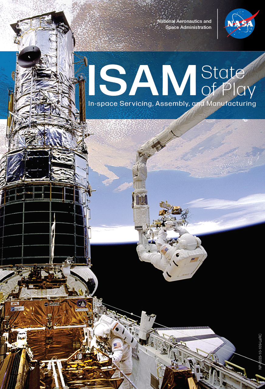
Cover of NASA's ISAM State of Play document, a survey of in-space servicing, assembly, and manufacturing capabilities across industry, academia, and government
The ISAM State of Play document is a survey of past, present, and near-future ISAM capabilities across industry, academia, and government agencies.
Credit: NASA

That tool scrapes aerospace news from across the web, compiles relevant updates into organized tables, and produces a readable summary on a regular cadence. “It kind of replaced the need for everyone on the team to spend 30 or 40 minutes every day scrolling through news to keep up,” he says.

“Jaden was constantly looking for ways to improve himself, the team, and our products,” Arney adds. “He was eager to take the lead in trying a number of new processes and ideas to try to make them work for us.” 

No Silos

The thing that surprised Caradine most about NASA Langley had nothing to do with the technical work. He had expected some departmental siloing that could develop in large organizations, where people become experts in narrow areas with limited cross-pollination among teams.

“That’s not something I’ve experienced here,” he says. “We all talk to each other, across all teams. We share resources. We collaborate quite extensively.” He describes a culture that expects everyone to engage with the whole problem, not just their corner of it. “Everyone kind of bounces around on different teams to learn the whole aspect of the problem and support each other.”

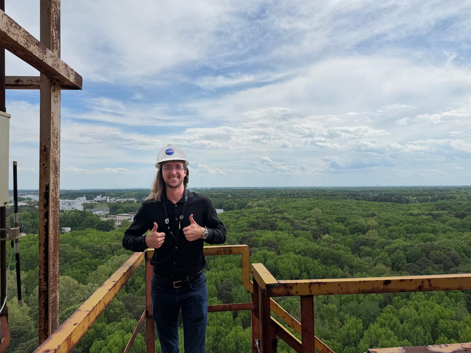
Jaden Caradine standing atop the gantry at NASA Langley's Impact Dynamics Facility
Caradine at NASA Langley’s Impact Dynamics Facility, enjoying the view at the top of the gantry
Credit: NASA

For anyone considering the Pathways program, his advice is direct. “Do it,” he says. “Human beings are far more capable than we give ourselves credit for. If it seems like too much, break it down. A journey of a thousand miles starts with a single step and can only be taken one step at a time.”

Caradine heads back to Embry-Riddle as a junior this fall, with plans to return to Langley next summer. Grad school is on the horizon, and he’s exploring programs that nurture important analysis skills for SMAB, including decision, strategic, and systems analysis.

“Before coming here, I was trying to do everything and cast a wide net,” he says. “Now I know what I need to know how to do. That’ll give me the opportunity to focus my efforts on the high-value skill sets.”

On Caradine’s Sci-Fi Shelf

The Sirens of Titan by Kurt Vonnegut

Dungeon Crawler Carl by Matt Dinniman

Caradine’s instinct runs more toward fantasy than science fiction, but this one, he says, hits something real.

“I enjoy the leveling aspect — constantly improving, constantly getting better. In books it might be physical strength, but in reality, strength takes on many different forms. Constant improvement is quite rewarding in real life, as it is in books.”

The audiobook production, he adds, is its own experience: full sound design, character actors, the works. “It’s like listening to a movie.”

The team also recently convinced him to start Dune, by Frank Herbert. He’s about halfway through.


Part of the Systems Analysis and Concepts Directorate at NASA’s Langley Research Center.
Learn more about our work by visiting our website.

  •  

NASA Calls for Proposals to Accelerate Lunar Surface Technologies 

Artistic concept of lunar surface technologies and infrastructure capabilities, including in-situ resource utilization oxygen production systems, surface power systems, in-space manufacturing tools, and advanced nanomaterials production.
Credit: NASA

NASA is seeking proposals to advance the technology and infrastructure needed to explore the Moon and establish a Moon Base in the lunar South Pole region.

Announced on Tuesday, Sept. 8, the solicitation targets capability gaps, including power generation, oxygen extraction, and producing materials on the Moon required for construction and operations. These technologies are essential to making humanity’s next great leap in lunar exploration.

“NASA is accelerating the development of key technologies and closing critical gaps needed for long-term human exploration at the Moon,” said Greg Stover, director of NASA’s Advanced Research and Technology Division. “Partnering with industry will strengthen the U.S. industrial base as we mature the capabilities and infrastructure needed for a sustainable lunar presence.”

The NextSTEP-3 Broad Agency Announcement Appendix A: Lunar Enabling Infrastructure Accelerator solicitation aims to mature and demonstrate capabilities in five areas:

  • Vertical solar array technology that can provide consistent power generation, management, distribution, and energy storage.
  • In-situ resource utilization oxygen from regolith production to extract usable oxygen molecularly bonded to rock and dust covering the Moon’s surface.
  • Radioisotope Stirling generator, a type of nuclear energy technology that uses heat from fissile materials to produce electric power for operating spacecraft systems in the darkest, dustiest, and most remote places.
  • In-space advanced manufacturing to reduce reliance on resupply missions from Earth and to optimize mission flexibility and resilience on the Moon.
  • Innovative nanomaterials production to advance the commercial availability and quality of nanomaterials that can be used in lunar exploration.

The solicitation intends to cultivate U.S.-led capabilities while maintaining full and open competition among private industry, academic institutions, and not‑for‑profit entities, as well as international partners participating through U.S.-led teams. 

NASA may apply insights gained from the resulting contracts of this solicitation, such as technical data, and demonstration results, to shape future acquisition strategies.  

To learn more about NextSTEP-3, visit:

https://go.nasa.gov/4x20o3t

-end-

Rob Margetta
Headquarters, Washington
202-358-0918
robert.j.margetta@nasa.gov

Share

Details

Last Updated
Sep 08, 2026
  •  

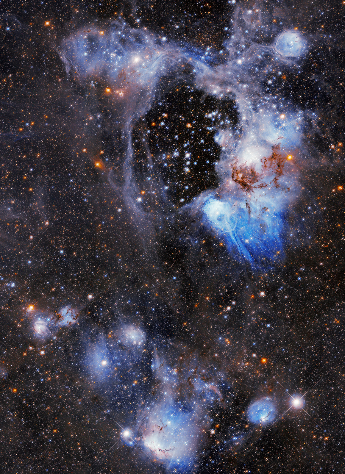
Superbubble in the Large Magellanic Cloud

Blue and orange stars shine through a wispy bubble of gas; the center is mostly clear, but blue and gray tendrils snake throughout most of the rest of the image. The background of the image is filled with other stars.
NASA, ESA/Hubble, D. Gouliermis

NASA’s Hubble Space Telescope captures a photogenic nebula, N44, in the Large Magellanic Cloud in this Sept. 3, 2026, image. N44 is dominated by two features: a vast central void and a shell of dense, dusty gas. The central void is a ‘superbubble’ spanning roughly 210 by 140 light-years across. The glittering stars at the center of the void are responsible for its creation; through their powerful stellar winds and explosive supernovae, these stars expelled much of the gas from which they were born.

Read more about this cosmic vista.

Image credit: NASA, ESA/Hubble, D. Gouliermis

  •  

NASA Technique for Manipulating Satellite Photos Now Reveals Ancient Images  

3 min read

Preparations for Next Moonwalk Simulations Underway (and Underwater)

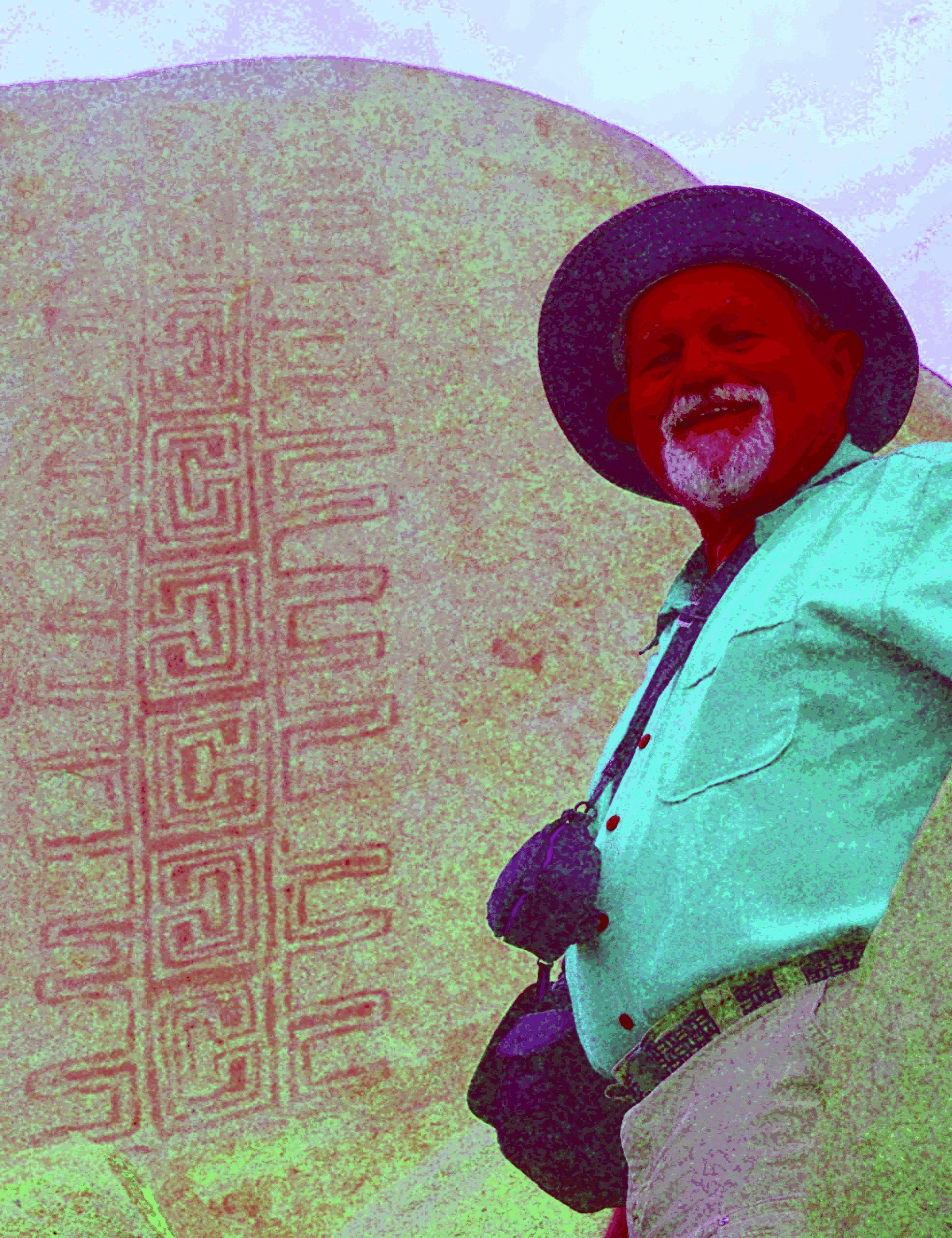
A man stands in front of a rock with art on it, the colors are intense and exaggerated revealing an intricate design in the rock's surface.
Jon Harman poses in front of an example of the Rancho Bernardo style of Native American artwork that’s barely visible until Dstretch is applied. 
Credit: Jon Harman 

High in the central tower in the ancient Cambodian temple of Angkor Wat, paintings depict horseback riders and a traditional musical ensemble. Thousands of visitors pass these images daily without noticing, because they’re faded to the point of invisibility. 

They were discovered between 2010 and 2012, along with about 200 other paintings throughout the complex, by an archaeologist using a method conceived at NASA’s Jet Propulsion Laboratory in Southern California. 

The technique, known as decorrelation stretch, heightens contrasts in digital imagery, making features easier to spot. It is especially popular for studying ancient rock art, partly due to the chance intersection of one man’s hobby with his professional background. 

Around 2005, rock art enthusiast Jon Harman saw NASA images depicting the Martian surface with and without the application of decorrelation stretch. Seeing how much detail the technique revealed, Harman, now retired in Pacifica, California, understood the implication for studying ancient, faded images. 

He also worked in medical imaging. “I Googled it and found a NASA paper that explained how to do the algorithm,” he said. “I knew from my medical imaging experience that I could do it, so I did.” 

The paper was written in 1996 by Ronald Alley, a JPL employee developing applications for the Advanced Spaceborne Thermal Emission and Reflection Radiometer (ASTER), a Japanese imaging instrument on NASA’s Terra satellite. One of Alley’s former supervisors at JPL had coinvented decorrelation stretch, and Alley had recognized its potential for gleaning information from ASTER imagery.  

Harman made his plug-in for use with ImageJ, an open-source program developed by the National Institutes of Health.  

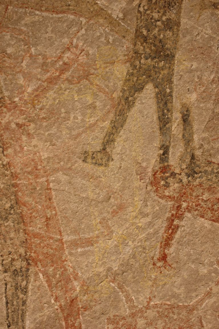
before
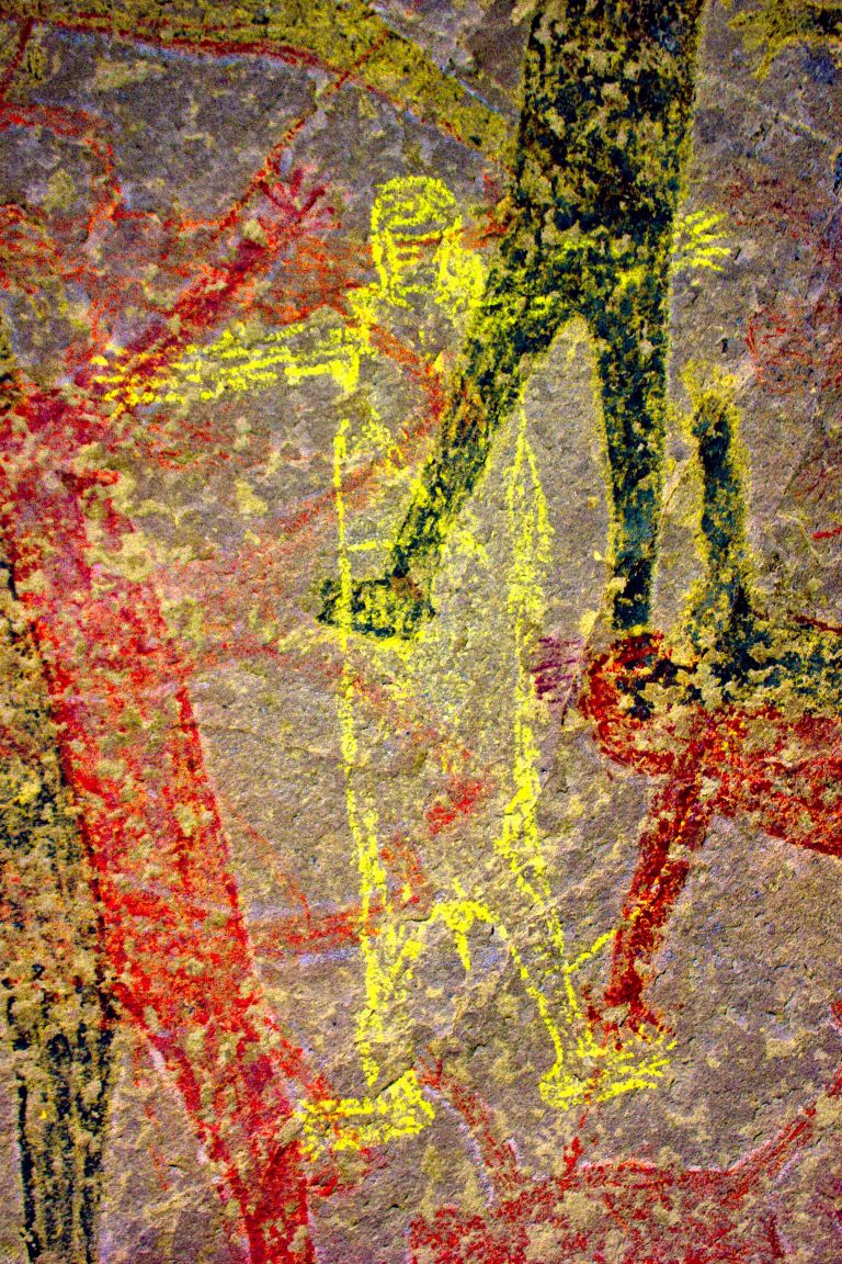
after
A wall with a series of faded humanoid figures painted on it.
A new yellow figure emerges from behind the other after the dstretch algorithm is applied
A wall with a series of faded humanoid figures painted on it.
A new yellow figure emerges from behind the other after the dstretch algorithm is applied
before
after

Before and After

Dstretch applied to Cave of San Borjitas in Baja California, Mexico

As Jon Harman was developing the Dstretch plug-in, he applied it to this image from the Cave of San Borjitas in Baja California, Mexico. When the yellow figure appeared in the middle of the picture, he knew he had something useful. Credit: Jon Harman 

He said he fulfills about 200 requests for Dstretch per year. Around 2010, he also created smartphone apps that use a shortcut to mimic decorrelation stretch. The apps have been downloaded thousands of times, and papers have been published describing Dstretch’s usefulness in archaeology. 

It has been used to spot and clarify imagery at ancient sites under a cliff in Norway, in an Egyptian tomb, at a park in Canada, and in many other locations. It has also helped archaeologists find buried remains of ancient Greek buildings and examine tattoos on mummified human remains, among its non-rock-art applications.  

Harman said he was not surprised Dstretch found wide use in the rock art community. “But I’ve been surprised by a lot of the different applications people have found. So that’s been cool.”  

Share

Details

Last Updated
Sep 08, 2026
  •  

1,000 Museum Visitors Dive Into NASA Sea Level Science on World Ocean Day

3 min read

1,000 Museum Visitors Dive Into NASA Sea Level Science on World Ocean Day

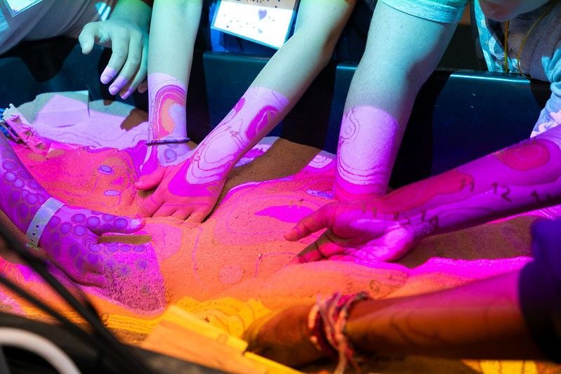
Several people place their hands and forearms on a brightly lit, abstract patterned surface under colorful fluorescent lighting.
Participants reach into an augmented reality sandbox, reshaping the terrain as projected contour lines and colors illustrate topographic features and elevation changes.
University of Georgia Marine Extension and Georgia Sea Grant

More than 1,000 visitors explored NASA sea level science firsthand during World Ocean Day at the University of Georgia Aquarium on Skidaway Island on June 6, 2026. The free event was supported by NASA’s Science Activation program through the Sea Level Education, Awareness, and Literacy (SEAL) project – a national effort that connects NASA sea level rise data with educators and coastal communities, particularly those historically underserved and already experiencing sea level impacts.

SEAL is a partnership between NASA and four NOAA Sea Grant programs working together to expand sea level rise understanding across U.S. coastal regions. By co-developing lesson plans, interactive activities, and place‑based learning experiences, SEAL helps educators engage learners with real NASA observations, models, and projections while strengthening community resilience to climate change.

During World Ocean Day, SEAL partners at Marine Extension and Georgia Sea Grant and the Coastal Equity and Resiliency Hub at Georgia Tech led hands‑on activities that brought sea level science to life. Visitors played the “Tumbling Tower” game, where removing blocks represents different community impacts from rising seas, and made “sea level friendship bracelets” that used colored glass beads to represent observed sea level rise along local coastlines.

The event also marked the debut of a new augmented reality sand box developed through SEAL. Guests shaped sand into coastal landscapes and watched NASA-informed sea level rise projections transform their creations in real time. Participants could experiment with resilience strategies, such as adding dunes or relocating homes, to see how adaptations might help communities prepare for future change.

Educators – formal, informal, home-based, and more – attending the event were able to take home four different SEAL lesson plans designed for both classrooms and informal learning settings. These materials help students explore sea level rise processes, modeling, variation, and impacts through NASA data and interactive STEM activities. SEAL aims to make all lesson plans developed through the project available online, but until then, please email Shannon Matzke to request digital copies.

“World Ocean Day is an annual tradition at the UGA Aquarium,” said Shannon Matzke, Marine Educator and Public Program Coordinator at UGA Marine Extension and Georgia Sea Grant. “With the support of NASA’s Science Activation program, this year’s event was free, which allowed us to reach more people and different audiences than we typically see. Incorporating SEAL activities made the day even more impactful for visitors – many of whom live in coastal communities already experiencing the effects of sea level rise.”

The SEAL project is supported by NASA cooperative agreement award number NNH21ZDA001N-SCIACT and is part of the NASA Science Activation Program portfolio, which connects learners with authentic NASA science experiences through partnerships with educators and community organizations.

  •  

NASA Astronaut Mike Fincke Leaves NASA, Career Includes 4 Spaceflights

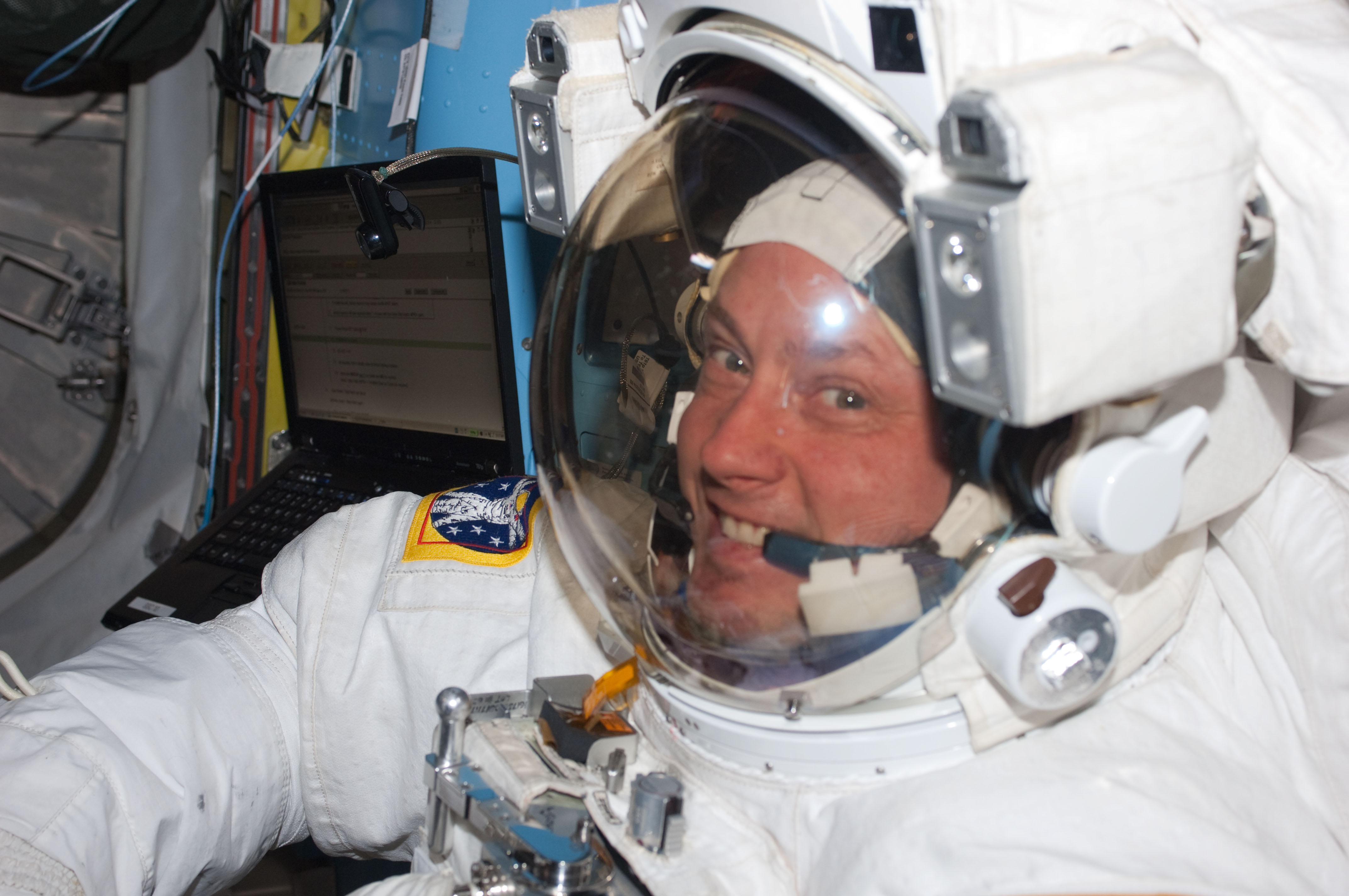
NASA astronaut Mike Fincke is pictured inside the International Space Station’s Quest airlock prior to the start of the third spacewalk for the STS-134 mission.
Credit: NASA

NASA astronaut Mike Fincke is departing the agency on Wednesday after 30 years of service. Throughout his career, he flew four missions, spent 549 days in space, and completed nine spacewalks in support of the International Space Station.

“Few people have had the opportunity to shape as many chapters of NASA’s history as Mike Fincke,” said NASA Administrator Jared Isaacman. “Over a remarkable career, Mike served our nation as a pilot, engineer, astronaut, and mentor. From long-duration missions aboard the International Space Station to helping prepare the Artemis generation, his contributions have helped position NASA for what comes next. The success we’re building on today is possible because of people like Mike, who dedicated their careers to moving our space program forward and preparing the next generation to carry the mission even further. I’d like to congratulate Mike on an incredible career and thank him for his decades of service to NASA, our nation, and the countless people who had the opportunity to learn from and fly alongside him.”

He ranks fourth among NASA astronauts in accumulated time in space, and his spacewalks total 48 hours and 37 minutes. Most recently, Fincke piloted NASA’s SpaceX Crew‑11 mission, which launched in August 2025 and returned in January. During the mission, he served as a flight engineer for International Space Station Expedition 73 and commander of Expedition 74.

Fincke joined NASA’s 16th astronaut class in 1996 and first flew to space in 2004 aboard Soyuz TMA‑4 in support of the space station’s Expedition 9. Serving as a science officer and flight engineer, he helped maintain station systems and performed four spacewalks. He returned to space in 2008 on Soyuz TMA‑13 as commander of Expedition 18, preparing the space station for its transition to six‑person crews at the time and completing two more spacewalks.

In 2011, Fincke flew on STS‑134, the final flight of space shuttle Endeavour. As mission specialist and robotic arm operator, he completed three spacewalks and helped deliver and install the Alpha Magnetic Spectrometer.

“Mike’s remarkable career reflects three decades of dedication to NASA’s mission and the advancement of human spaceflight,” said Vanessa Wyche, director of NASA’s Johnson Space Center in Houston. “From his time aboard the International Space Station to his commitment to mentoring the next generation, Mike has made an immense impact across our agency. His legacy of service, mentorship, and dedication to exploration will continue to inspire the generations to come.”

Throughout his career, Fincke bridged spacecraft development, flight testing, and mission operations. Early in the International Space Station Program, he helped test and integrate several of the station’s initial modules before launch. His flight experience spanned multiple generations of human spacecraft, including two missions aboard Soyuz, one aboard the space shuttle, and later piloting the SpaceX Dragon.

Fincke was a foundational contributor to NASA’s Commercial Crew Program. As chief of the Astronaut Office’s Commercial Crew Branch, he worked to ensure astronaut needs, crew safety, and human spaceflight experience informed development of the nation’s next generation of crewed spacecraft. He spent five years supporting Boeing’s Crew Flight Test program training as a crew member and backup pilot, contributing to flight software, systems integration, integrated testing, and spacecraft interfaces.

Fincke also supported station operations from the ground as a crew test support team member in Russia, a capsule communicator, or capcom, and crew procedures team lead. He helped translate complex engineering and operational requirements into clear instructions for crews working in orbit. His continuity across development, integration, mission support, and long‑duration flight gave him an end‑to‑end perspective on space station assembly and operation.

“Mike approached every assignment with experience, humility, and an unwavering focus on the mission,” said Scott Tingle, chief of the Astronaut Office at NASA Johnson. “Whether flying aboard the station, supporting crews from the ground, or helping shape the spacecraft that future crews will rely on, he consistently strengthened our team. His legacy is woven into the way we fly today.”

A native of Emsworth, Pennsylvania, Fincke holds bachelor’s degrees in aeronautics and astronautics and in Earth, atmospheric, and planetary sciences from the Massachusetts Institute of Technology, where he also studied in the Soviet Union through an exchange program with the Moscow Aviation Institute. He earned master’s degrees in aeronautics and astronautics from Stanford University and in planetary geology from the University of Houston, Clear Lake.

Fincke is a retired U.S. Air Force colonel and distinguished graduate of the U.S. Air Force Test Pilot School. He served as a space systems engineer and flight test engineer at Edwards and Eglin Air Force Bases and later as the U.S. flight test liaison to the Japanese‑U.S. XF‑2 fighter program at Gifu Air Base in Japan. He accumulated more than 2,000 flight hours in more than 30 aircraft types.

“After exactly 30 years, I am departing NASA, but I remain deeply committed to the work of exploration.” Fincke said. “NASA gave me the extraordinary privilege of serving alongside remarkable people, flying and helping develop spacecraft, and contributing to the International Space Station from its earliest days through command in orbit. I am profoundly grateful to my crewmates, the teams on the ground, our international partners, and the families who make this work possible. I am excited to carry those lessons forward and help prepare the next generation of engineers, explorers, and leaders. Together, we will return humanity to the Moon, travel to Mars, journey outward to the planets and moons beyond Earth, and someday reach for the stars – all while caring for Earth, the most beautiful planet in our solar system.”

To learn more about NASA’s astronauts and space exploration, visit:

https://www.nasa.gov/astronauts

-end-

Jimi Russell
Headquarters, Washington
202-358-1100
james.j.russell@nasa.gov

Anna Schneider
Johnson Space Center, Houston
281-483-5111
anna.c.schneider@nasa.gov

Share

Details

Last Updated
Aug 12, 2026
  •  

Pursuing a Dream of Working for NASA

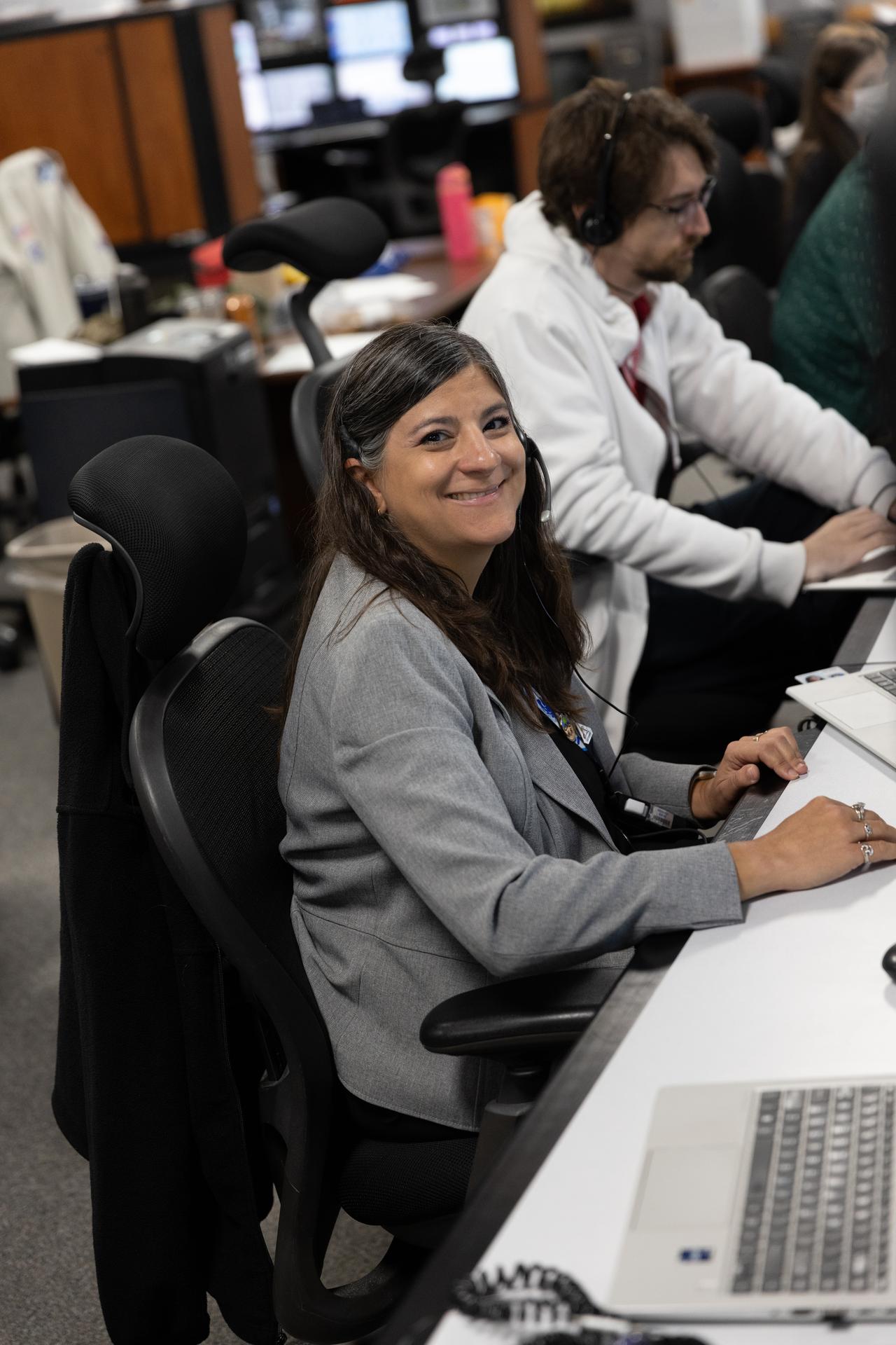
A women with dark brown hair smiles at the camera for a photograph. The woman is wearing a grey jacket and a headset while she sits at the desk with a computer;
Lindsey Waitt, engineer with NASA’s Exploration Ground Systems Program, participates in a terminal countdown simulation for Artemis III on Thursday, Aug. 6, 2026, inside Firing Room 1 of the Rocco A. Petrone Launch Control Center at NASA’s Kennedy Space Center in Florida.
NASA/Clayton Rougelot

As a young girl raised in Worcester, Massachusetts, Lindsey Waitt dreamed of working for NASA. Her dream is now a reality as she embarks on her role as a NASA test project engineer with the Artemis launch team – an integral part of the agency’s missions that will enable humans to return to the surface of the Moon after launching from NASA’s Kennedy Space Center in Florida.

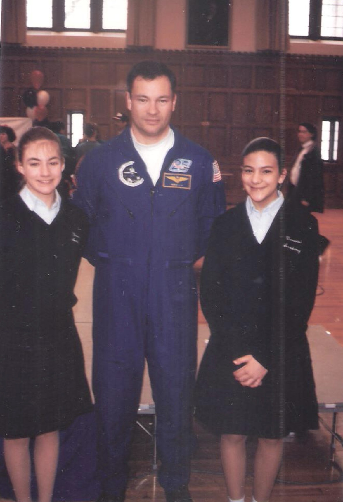
When she was in middle school in the late 1990’s, Waitt recalls meeting NASA Space Shuttle astronauts Michael Lopez-Alegria and Albert Sacco, Jr., a former professor at the college, during a visit to Worcester Polytechnic Institute (WPI) in Worcester, Massachusetts. She was inspired while listening to them recount their spaceflight experiences including an experiment on conducting research for growing cells on the Moon. She even posed for a picture and got their autographs. Little did young Waitt know, these would not be the only astronauts she would meet.

The photo features two young ladies in black dresses posing for a photograph with a NASA astronaut Michael Lopez-Alegria standing in the middle between the two young ladies.
Lindsey Waitt (far right), poses for a photograph with NASA astronaut Michael Lopez-Alegria and her cousin at Worcester Polytechnic Institute in Massachusetts.
Photo credit: NASA/Lindsey Waitt

Her passion for learning about all things space and engineering led Waitt back to WPI where she studied engineering, absorbing different disciplines. She received her Bachelor of Science degree in Mechanical Engineering with a concentration in aerospace engineering and she left the school fueled by her passion to be a part of America’s space agency.

After graduation, she worked as a systems engineer on radar flight test missions for a defense contractor, and while excelling in her role, she realized it wasn’t the aerospace engineering field that she desired.

“It was an exciting program, and it was meaningful to be a part of a project focused on protecting the country from enemy attacks. But it wasn’t space,” Waitt said.

As the wife of a now retired sergeant first class officer in the United States Army, Waitt and her family traveled around the world during her husband’s enlistment, and she continued to follow NASA missions from around the globe. While Waitt was dedicated to raising her three young boys, she simultaneously pursued her master’s degree in Space Operations from the University of Colorado in Colorado Springs. Twelve years later, she made the courageous decision to fully return to her first career passion – working for NASA – despite nay-sayers suggesting too much time had passed for her to return to the industry.

The sky is not the limit, it's wide open now. The universe is the limit.

Lindsey waitt

Lindsey waitt

Test project engineer

Waitt vividly remembers watching NASA astronauts Doug Hurley and Bob Behnken soar skyward during NASA’s first commercial crew mission to the International Space Station in 2020. Watching alongside her family, she even set up a rocket-shaped tent, and she and her children pretended to blast off from their yard as they cheered excitedly as the astronauts lifted off from what would be her future place of work.

After moving to Florida in 2022 to work at a small satellite company in Cape Canaveral, as a systems engineer and program manager, she continued to search for opportunities to work for the agency. Waitt vividly remembers watching Artemis I with her family. They had just moved to the Sunshine State, and she woke up in the early hours of the morning to watch the historic launch, having no idea she would be working on the next Artemis mission – the first time NASA sent humans around the Moon in over 50 years!

In 2024, Waitt began her career at Kennedy working for a contractor as a test project engineer during the Artemis II launch. As “problem-solvers,” test project engineers are the main hub of experts for technical tests and launch activities and they work to coordinate resolutions across the different subsystems that may arise during the dynamic operations associated with a rocket launch. Leading up to the Artemis II launch in April, Waitt quickly became certified to sit on the launch console during the dynamic pre and post-launch operations for the massive SLS (Space Launch System) rocket and Orion spacecraft and she eagerly watched from outside Kennedy’s Launch Control Center as the four crew members lifted off the launch pad towards the Moon.

When NASA announced its insourcing initiative earlier this year, Waitt seized the opportunity to fully realize her dream. She applied for a position and is now a NASA civil servant supporting the Artemis launch team as a test project engineer for NASA– a core position for the agency’s launch team. With Artemis III in front of her, Lindsey will see the buildup of launch operations from start to finish.

As the only female of the 14 test project engineers who work on the Artemis launch team, Waitt said she was fully embraced by the colleagues she stands beside.

“Everybody’s very open and welcoming,” Waitt said. “I’ve worked on teams before, but it’s never been like this. Everyone is so passionate about the mission, and everybody is working together to get things done quickly, but safely – that’s always first priority.  We Are Going.”

This opportunity didn’t happen by chance. Waitt is embracing life’s journey and focused on making her dream come true, one launch at a time. “The sky is not the limit – it’s wide open now,” Waitt said. “The universe is the limit.”

  •  

APOD: 2026 August 12 – Perseids over a Little Planet

APOD

Astronomy Picture of the Day

Discover the cosmos! Each day a different image or photograph of our fascinating universe is featured, along with a brief explanation written by a professional astronomer.

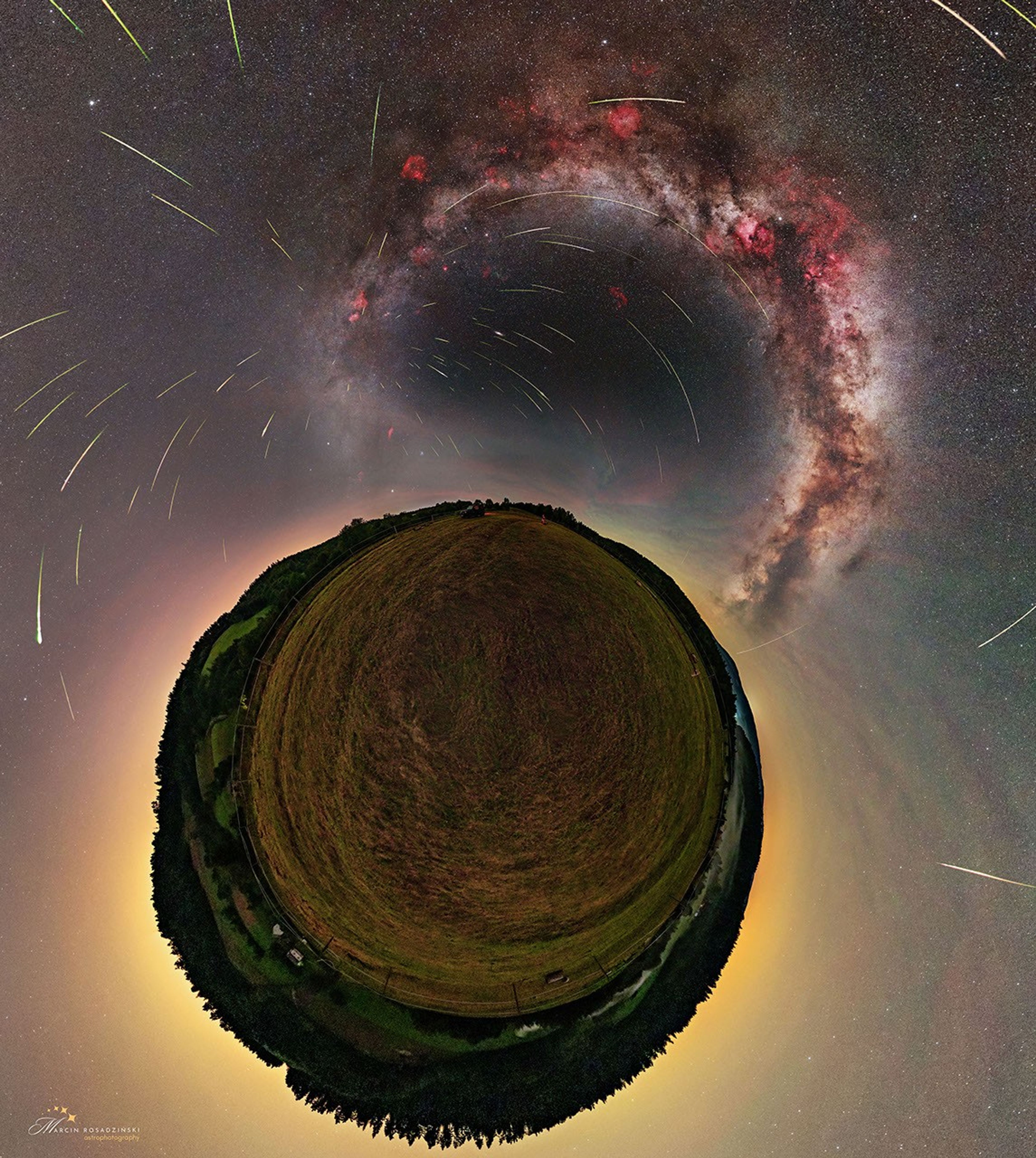
The ground is shown in a little planet perspective, surrounded by the sky with a diffuse glow. The Milky Way is visible in the sky, as well as some nebulae in red and over a hundred meteors. Most of them appear to come from the same point.

Perseids over a Little Planet

Explanation: It looks like a view from the Little Prince‘s planet. The featured image is a throwback to the 2024 Perseid meteor shower, surrounded in this projection by the Bieszczady Mountains in Poland. Visible in the sky is the arch of the Milky Way, along with several nebulas in red and over a hundred meteors pointing to the radiant. The Perseids are easily visible and quite popular in the Northern Hemisphere summer. (Watching meteor showers in the winter is less convenient for a good reason). This year they are expected to offer an even more dazzling spectacle than usual, because the peak coincides with a new moon. The 2026 Perseid meteor shower will peak tonight with as many as 50-100 meteors per hour, when the Earth’s path crosses through debris left behind by Comet Swift-Tuttle. Typically, the best times for seeing the meteors are between midnight and pre-dawn. You won’t need binoculars to see the meteors, but a lawn chair and a dark sky location help.

NASA Stream: August 12 Total Solar Eclipse.
Tomorrow’s picture: pixels in space

Date August 12, 2026
Credit & Copyright: Marcin Rosadziński
Authors & editors: Cecilia Chirenti, Jerry Bonnell, Robert Nemiroff, Keighley Rockcliffe
A service of: ASD at NASA / GSFC,
NASA Science Activation & Michigan Tech. U.
  •  

Quality Assessment Report Evaluates Polar Geospatial Center EarthDEM Elevation Products

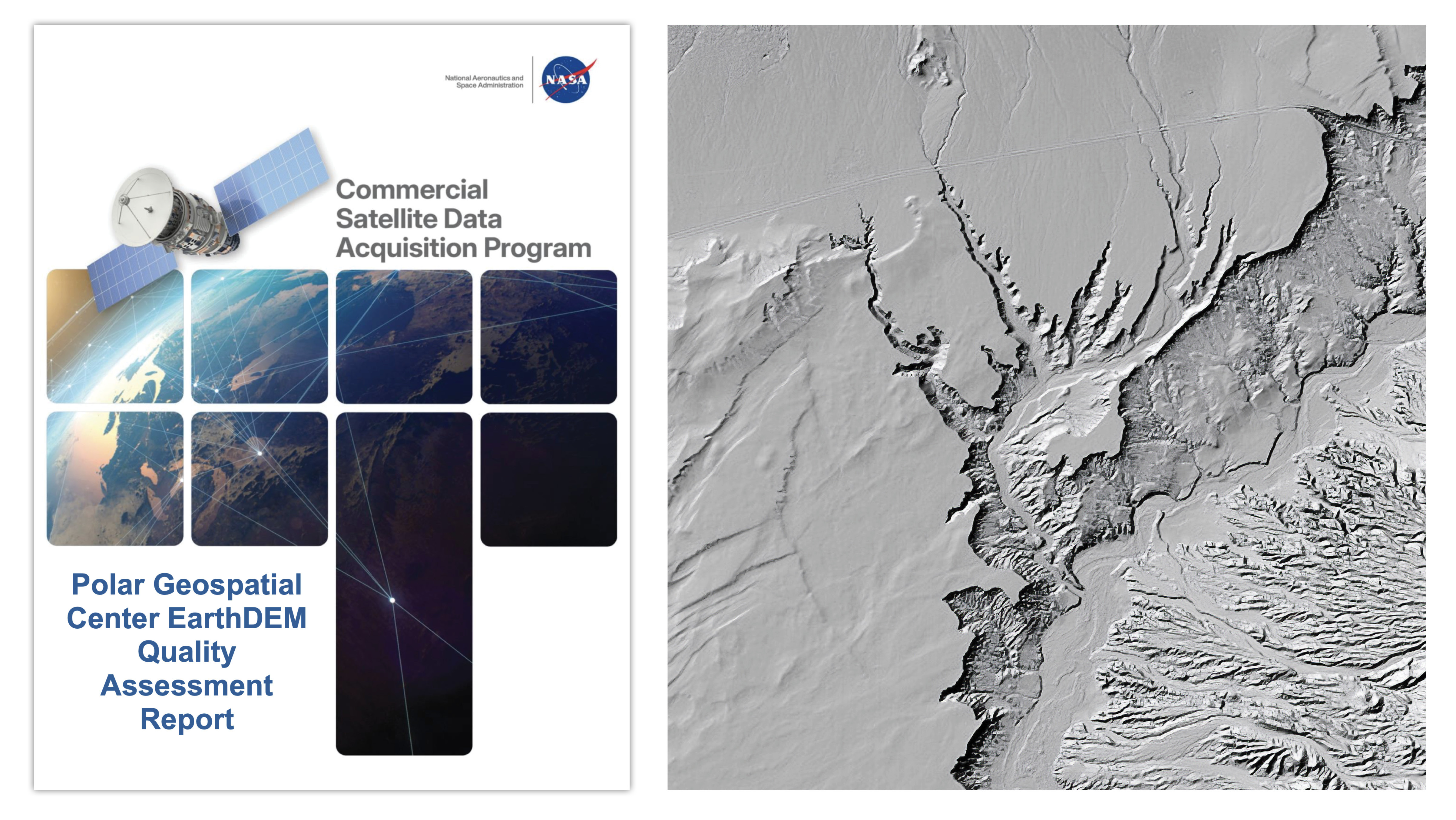
A new quality assessment report from NASA’s Commercial Satellite Data Acquisition (CSDA) program evaluates data from the Polar Geospatial Center’s (PGC) EarthDEM product. The results of the evaluation help inform NASA program management and the user community about the quality of commercial Digital Elevation Models (DEMs) for use in NASA science.

At left, the cover of the rogram recently released Polar Geospatial Center EarthDEM Quality Assessment Report, which features an image of a satellite on a white field over an image of Earth from space that divided into squares. Shaded relief rendering of EarthDEM data showing the Virgin River, Nevada. DEM derived from Vantor imagery. Credit: EarthDEM Project.
At left, the cover of the Commercial Satellite Data Acquisition programs’s recently released Polar Geospatial Center EarthDEM Quality Assessment Report. At right, a shaded relief rendering of EarthDEM data showing the Virgin River in Nevada. DEM derived from Vantor imagery.
Credit: NASA CSDA program/EarthDEM Project

Issued August 8, 2026, the CSDA  Polar Geospatial Center EarthDEM Quality Assessment Reportwas conducted by NASA Digital Elevation Model (DEM) subject matter experts (SMEs) enlisted to evaluate the horizontal and vertical accuracy of two PGC EarthDEM1 (i.e., Digital Elevation Model) products: the center’s “Mosaic Tile” and “Strip” Digital Surface Models (DSMs).

To assess the vertical and horizontal accuracy of the EarthDEM Strip DSM and Mosaic Tile products over a variety of surface characteristics, the SMEs compared them to airborne lidar data samples from across the United States and Senegal. They found the horizontal accuracy of the EarthDEM products (Strip DSM: 0.5-meter (m) Root Mean Square Error Horizontal (RMSEH); Mosaic Tile: 0.3 m RMSEH) agreed with the specifications provided by the PGC and graded them “Excellent.”  The vertical accuracy results of the EarthDEM Strip DSM (5.6 m Root Mean Square Error Vertical (RMSEV)) and the Mosaic Tile (4.9 m RMSEV) products varied by land cover type, with all land cover types exceeding the specification provided by the PGC (0.5 m RMSEV). Strip DSM vertical accuracy was found to vary from 4.6-6.8 m RMSEV depending on the cloud cover metadata field generated by the PGC. Given this variation, the vertical accuracy compliance for the EarthDEM products was graded as “Basic.”

Overall, the assessment report supports the use of EarthDEM data for NASA Earth science research and applications, as long as the data characteristics (e.g., vertical accuracy, poor cloud masking, missing surface features, data voids, etc.) are compatible with the specific science objectives and use cases.

The report also provides a Data Provider Documentation Review for the EarthDEM product that evaluated information from the PGC website, as well as a series of peer-reviewed publications by researchers at The Ohio State University’s Byrd Polar and Climate Research Center. (Only documents listed in this report were considered in the evaluation.) The report’s authors found that, overall, the EarthDEM product is “well documented,” with most information present within the product User Guide, a series of peer reviewed papers, or the PGC GitHub repository.

About the CSDA Program

The CSDA program was established to identify, evaluate, and acquire data from commercial sources that support the NASA Earth science research and application goals. NASA’s Earth Science Division recognizes the potential impact commercial satellite constellations may have in encouraging/enabling efficient approaches to advancing Earth System Science and applications development for societal benefit. Commercially acquired data may also provide a cost-effective means to augment and/or complement the suite of Earth observations acquired by NASA, other U.S. government agencies, and international partners.

To read the reports in full, see the links under “Evaluation” heading on the Polar Geospatial Center vendor page on the CSDA website.

Notes:

1. According the authors of the report, “it should be noted that the PGC EarthDEM product is not technically a commercial product…. EarthDEM is a digital elevation dataset derived from imagery collected from the Vantor (formerly Maxar) fleet of optical satellites.”

  •  

Stops Along the Path of Totality

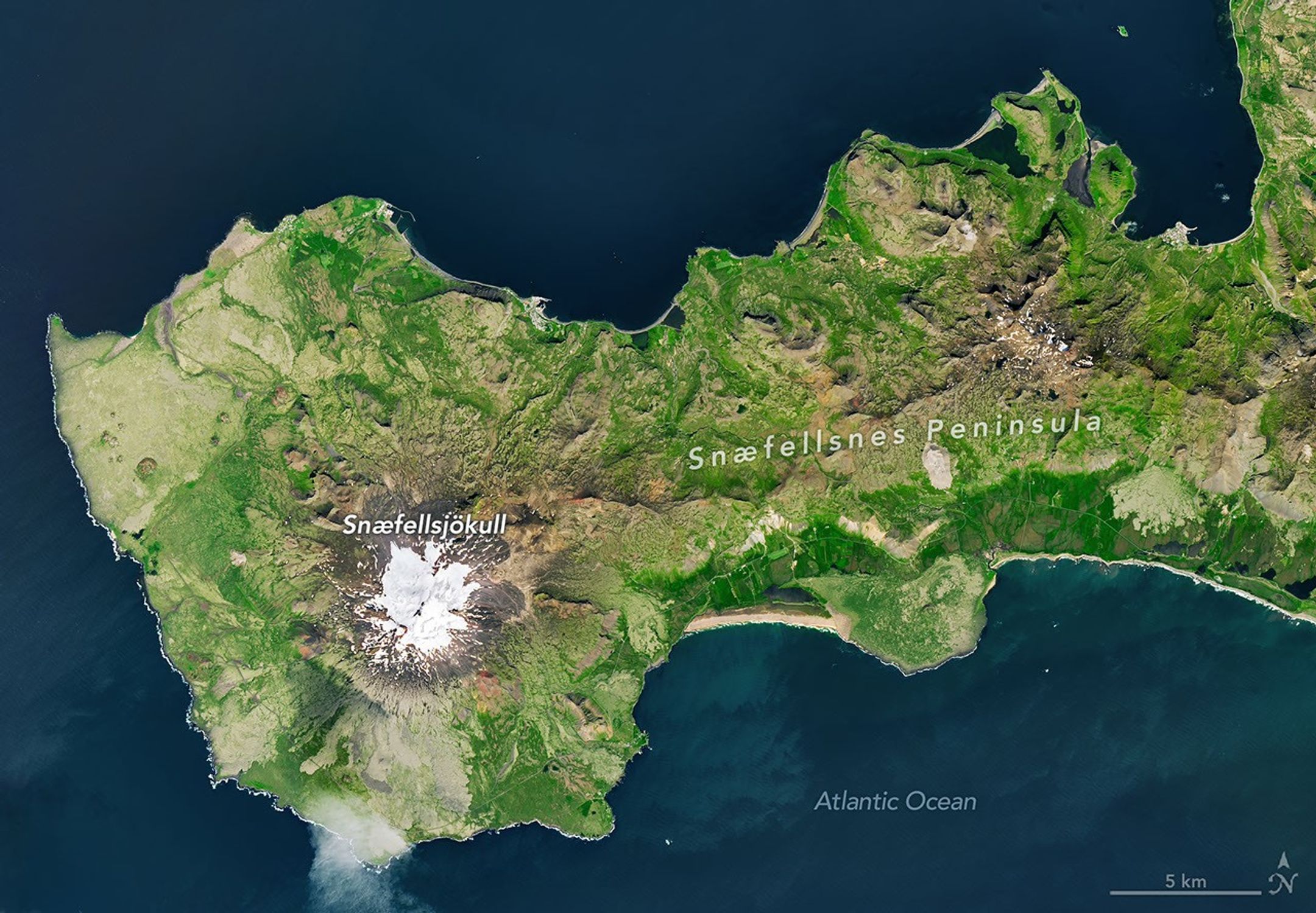
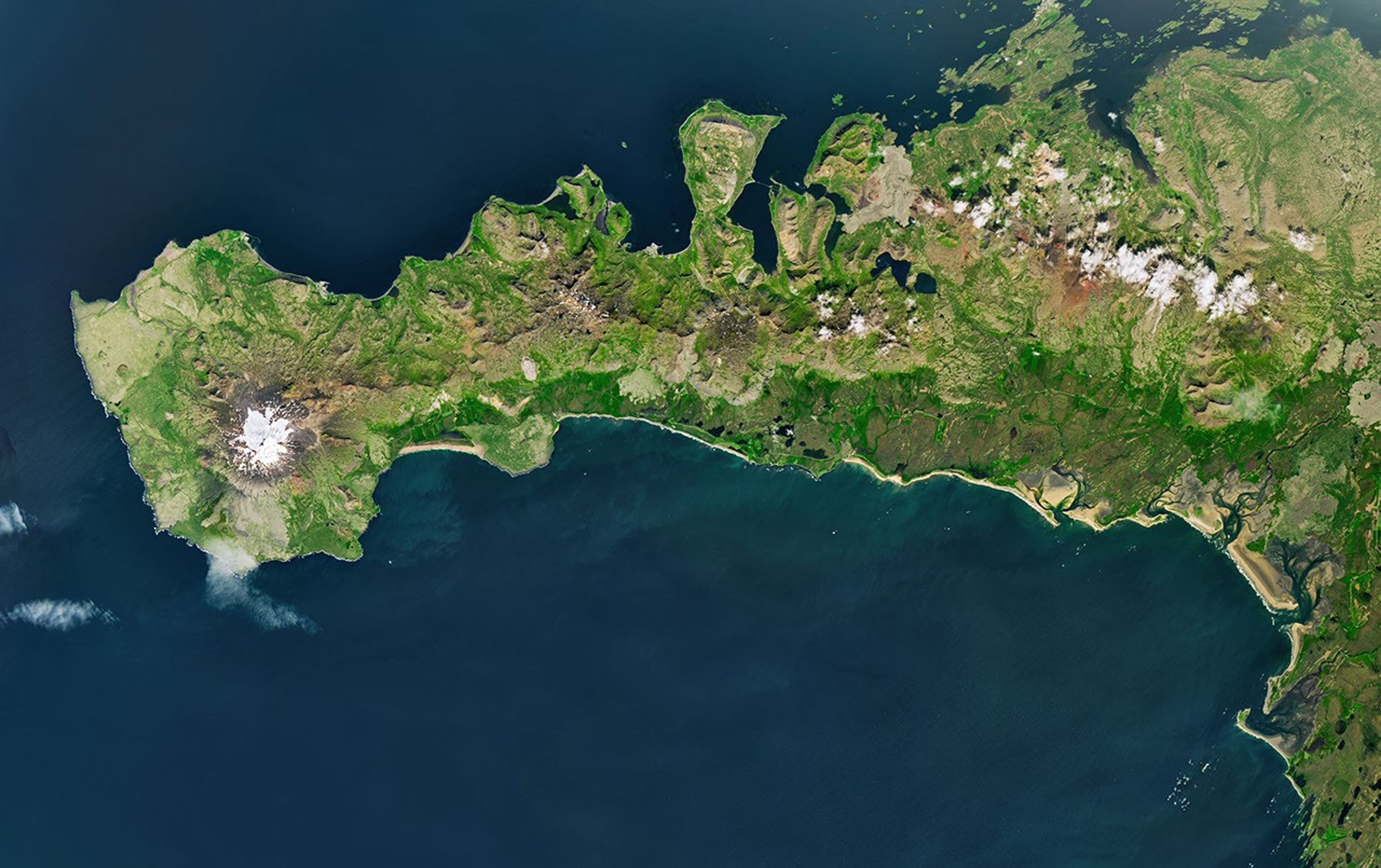
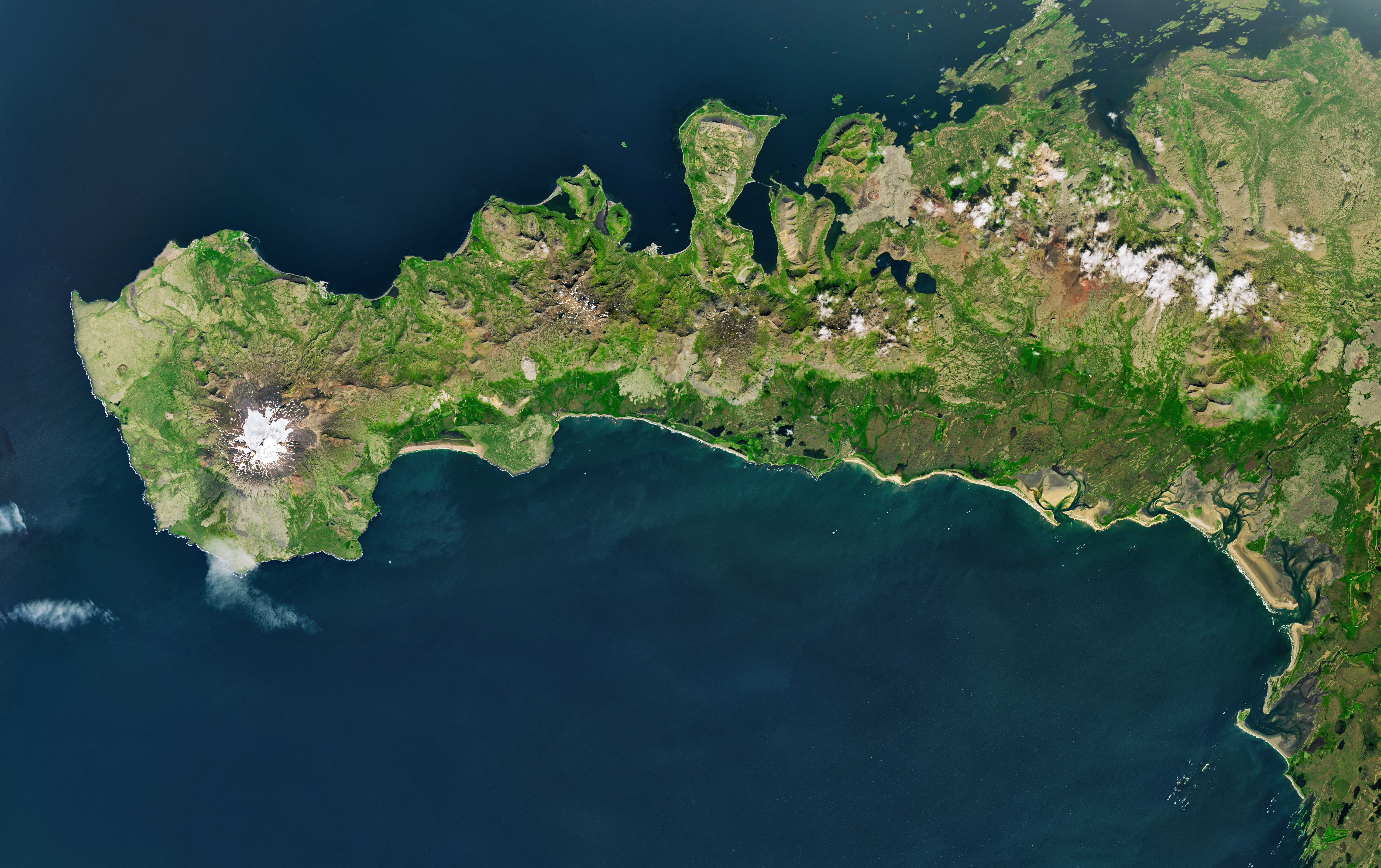
A peninsula in Iceland stretches across the image to the left. A prominent glacier-capped volcano sits near its western end.
The glacier-capped Snæfellsjökull volcano is the defining feature of Iceland’s Snæfellsnes peninsula, shown in this image acquired with the OLI (Operational Land Imager) on Landsat 9 on July 25, 2026.
NASA Earth Observatory/Michala Garrison

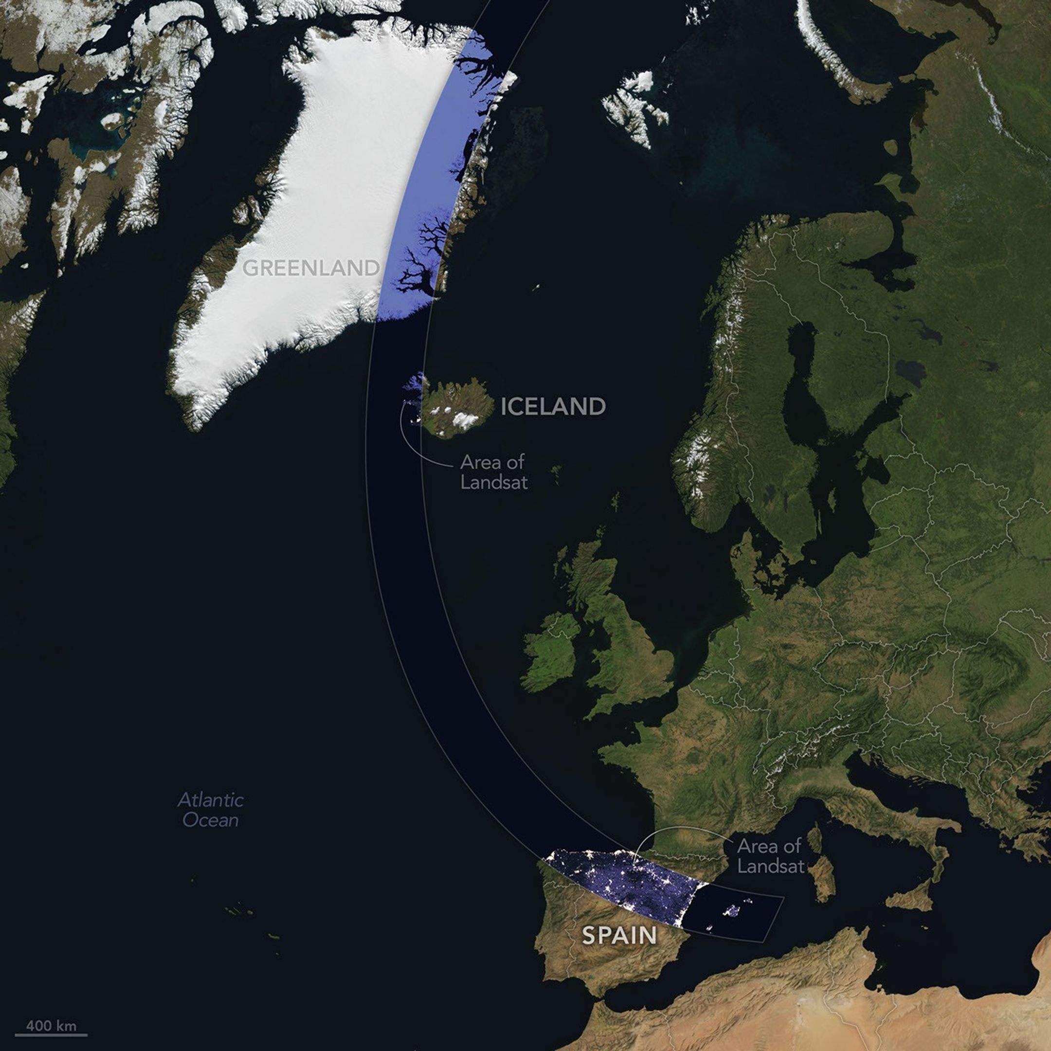
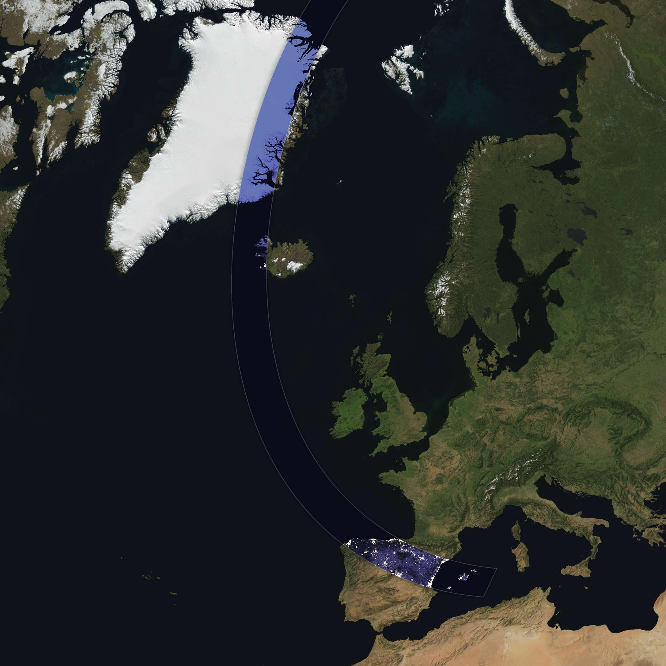
The Sun, Moon, and Earth align on August 12, 2026, to produce a total solar eclipse. When this celestial event last occurred, on April 8, 2024, the path of totality stretched across North America, giving millions the chance to glimpse the Sun’s corona. In 2026, the viewing locales are more limited; only a handful of land areas in the Northern Hemisphere, including parts of Iceland and Spain, fall within the path of totality.

On August 12, the Moon’s shadow will first cross over the Arctic Circle from northern Russia and then track along the eastern side of Greenland. At about 5:45 p.m. local time in Iceland (17:45 Universal Time), the country’s western fringes—including the Snæfellsnes peninsula, shown in the Landsat image above—will begin to experience totality. The greatest eclipse will occur near this sparsely populated peninsula when the Moon appears the largest and covers more of the Sun.

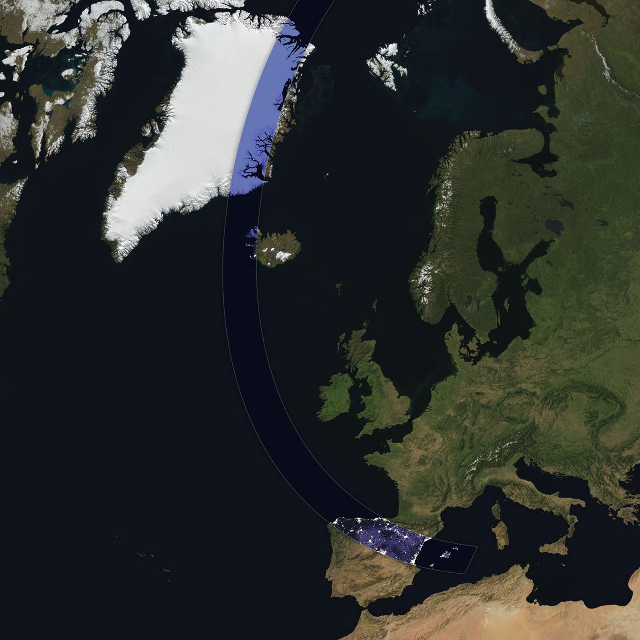
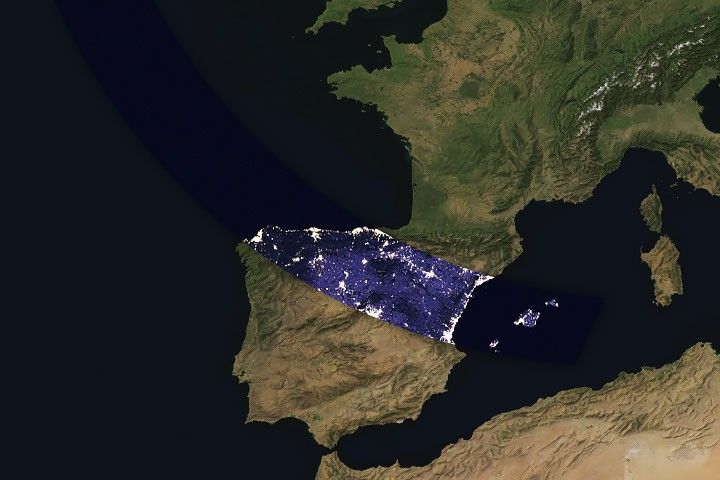
A map shows the path of totality of the solar eclipse on August 12, 2026, arcing across Greenland, Iceland, the North Atlantic, and Spain.
The path of totality of the solar eclipse on August 12, 2026, spans Greenland, Iceland, and Spain. The base imagery for the map comes from Blue Marble: Next Generation, with data from Black Marble shown in the path of totality. Blue Marble is built from scenes captured by MODIS (Moderate Resolution Imaging Spectroradiometer), while Black Marble is based on observations by the VIIRS (Visible Infrared Imaging Radiometer Suite) day-night band.
NASA Earth Observatory/Michala Garrison

The Snæfellsjökull volcano on the western end of the peninsula is covered in ice and last erupted about 1,800 years ago. It is the highlight of a national park of the same name, where people are expected to visit to view the eclipse. The stratovolcano even has a literary claim to fame: in Jules Verne’s A Journey to the Center of the Earth, characters venture underground through its crater, later emerging in an eruption of Stromboli, in Italy. In 2025, a broader area of the peninsula was designated a UNESCO biosphere reserve, containing over 70 percent of Iceland’s flora and an agglomeration of volcanic landscapes, wetlands, and grasslands.

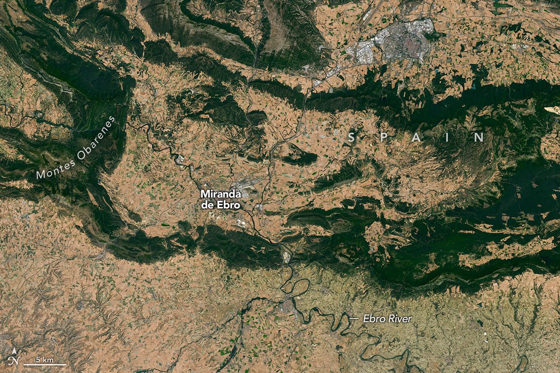
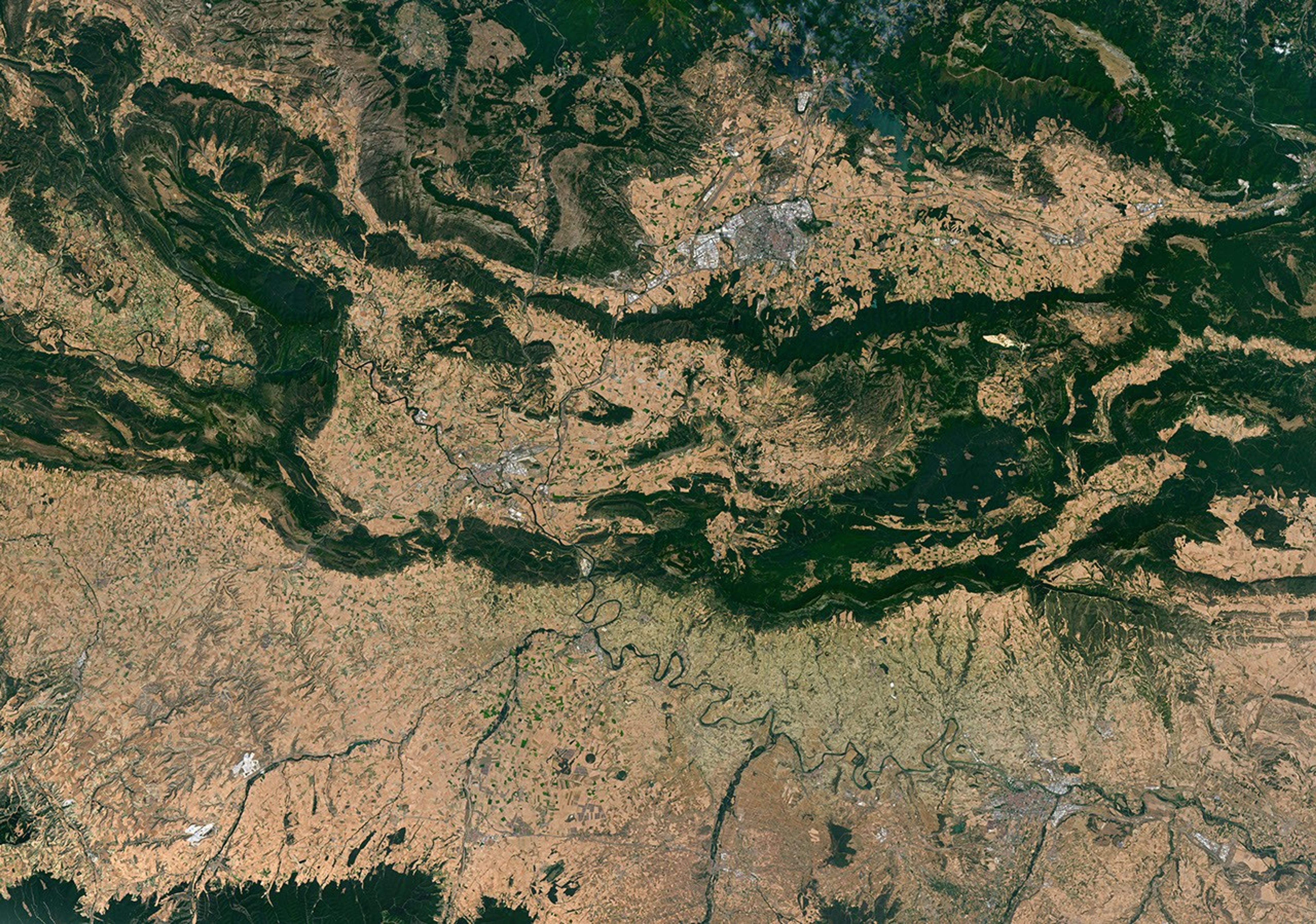
From Iceland, the eclipse shadow, or umbra, progresses across the North Atlantic and reaches northern Spain shortly before sunset. It runs east-southeast across the country, much like the Ebro River (Río Ebro), seen in the Landsat image below.

Meandering rivers cut through dark green mountain ridges, across agricultural land, and near several developed areas in northern Spain.

The Ebro River, meandering across northern Spain in this image acquired with the OLI (Operational Land Imager) on Landsat 8 on July 21, 2026, is in the path of totality of the August 2026 solar eclipse.
NASA Earth Observatory/Michala Garrison

The upper Ebro emerges from rugged terrain in Parque Natural de Montes Obarenes-San Zadornil, where it carves canyons and gorges through the eastern foothills of the Cantabrian Mountains. It then meanders through La Rioja, a region known for its vineyards. About 400 kilometers (250 miles) away, the river reaches a delta on the Mediterranean coast between Barcelona and Valencia.

Based on satellite measurements of cloud cover in August over several decades, viewers in Spain have a higher likelihood than those in Iceland of getting a clear look at the eclipse. And despite limited viewing opportunities in the path of totality, the rest of Europe, parts of Africa, Canada, and the northern and northeastern U.S. will experience a partial eclipse.

NASA Earth Observatory images and map by Michala Garrison, using Landsat data from the U.S. Geological Survey, base imagery from Blue Marble: Next Generation and Black Marble, and eclipse path data from Xavier Jubier. Story by Lindsey Doermann.

Downloads

A peninsula in Iceland stretches across the image to the left. A prominent glacier-capped volcano sits near its western end.

July 25, 2026

JPEG (14.69 MB)

A map shows the path of totality of the solar eclipse on August 12, 2026, arcing across Greenland, Iceland, the North Atlantic, and Spain.

August 12, 2026

JPEG (1.92 MB)

Meandering rivers cut through dark green mountain ridges, across agricultural land, and near several developed areas in northern Spain.


July 21, 2026

JPEG (34.46 MB)

References & Resources

You may also be interested in:

Stay up-to-date with the latest content from NASA as we explore the universe and discover more about our home planet.

Colonial National Historical Park

2 min read

The colonial communities of “America’s historic triangle” played defining roles in the road to American independence.

Article

Minute Man National Historical Park

3 min read

Sites relevant to the start of the American Revolutionary War are interspersed throughout the modern-day Boston metropolitan region.

Article

Earthset From the Lunar Far Side

2 min read

The crew of NASA’s Artemis II mission captured extraordinary images of our home planet during their journey around the far…
Article
  •  

What Is the Nancy Grace Roman Space Telescope? (Grades 5-8)

6 min read

Preparations for Next Moonwalk Simulations Underway (and Underwater)

This article is for students grades 5-8.

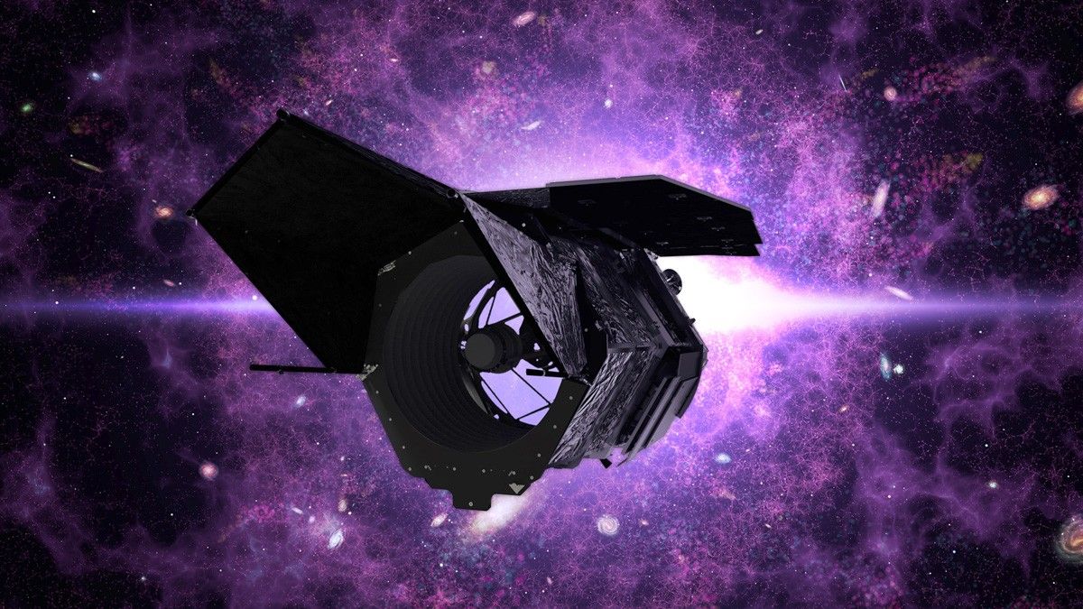
The Nancy Grace Roman Space Telescope is NASA’s newest astrophysics observatory. The telescope will scan large sections of space. Roman will help astronomers answer questions about dark energy, dark matter, exoplanets, and more.

Image shows an illustration of the Nancy Grace Roman Space Telescope with a galaxy illustration in the background. Formerly known as WFIRST, is an upcoming space telescope designed to perform wide-field imaging and spectroscopy of the infrared sky.
The Nancy Grace Roman Space Telescope is NASA’s newest space telescope that will study dark energy, exoplanets, and astrophysics.
NASA’s Goddard Space Flight Center

______________________________________________________________________

Words to Know

Astrophysics: a branch of space science that applies physics and mathematics to study the universe.

Lagrange point: a position in space where the gravitational forces of a two-body system, such as the Sun and Earth, are balanced. This point creates an “orbital parking spot” where minimal fuel is needed to maintain a spacecraft’s position.

Infrared light: light that is completely invisible to the human eye but can be felt as heat. It’s the area on the electromagnetic spectrum where wavelengths are longer than visible red light, but shorter than microwaves.

Dark energy: the mysterious force that is causing the universe to expand at an accelerated rate.

Exoplanet: a planet outside of our solar system.

Dark matter: the mysterious gravitational “glue” that holds cosmic structures together.

______________________________________________________________________

When and Where Will the Nancy Grace Roman Space Telescope Launch?

The Nancy Grace Roman Space Telescope is scheduled to launch Aug. 30, 2026. It will launch aboard a SpaceX Falcon Heavy rocket. Liftoff will take place from Launch Complex 39A at NASA’s Kennedy Space Center in Florida.

Where Will the Nancy Grace Roman Space Telescope Go in Space?

The Nancy Grace Roman Space Telescope will orbit about 930,000 miles (1.5 million kilometers) away from Earth. It will orbit around a special place in space called the second Sun-Earth Lagrange point, or L2. This gravitational sweet spot is perfect for unobstructed views of the universe.

What Instruments Does the Nancy Grace Roman Space Telescope Have?

The Nancy Grace Roman Space Telescope will peer through dust and across vast stretches of space using infrared light. Roman’s primary mirror is 7.9 feet (2.4 meters) across. The large surface of the telescope mirror gathers lots of light. More light equals finer details.

The primary mirror will send light to Roman’s two science instruments: the Wide Field Instrument and the Coronagraph Instrument.

The Wide Field Instrument is a 300-megapixel infrared camera. It allows scientists to look very far back in time because the light captured by the camera has been traveling for billions of years before reaching the instrument. Seeing the universe in its early stages will help unravel how it has expanded throughout its history. This will give scientists hints about how the universe may continue to evolve.

The Coronagraph Instrument uses technology that blocks the glare from a star. This lets astronomers see planets in orbit around it. This instrument is the most powerful coronagraph ever flown in space. It will allow astronomers to see planets that are almost a billion times fainter than their host star.

A large group of technicians in white
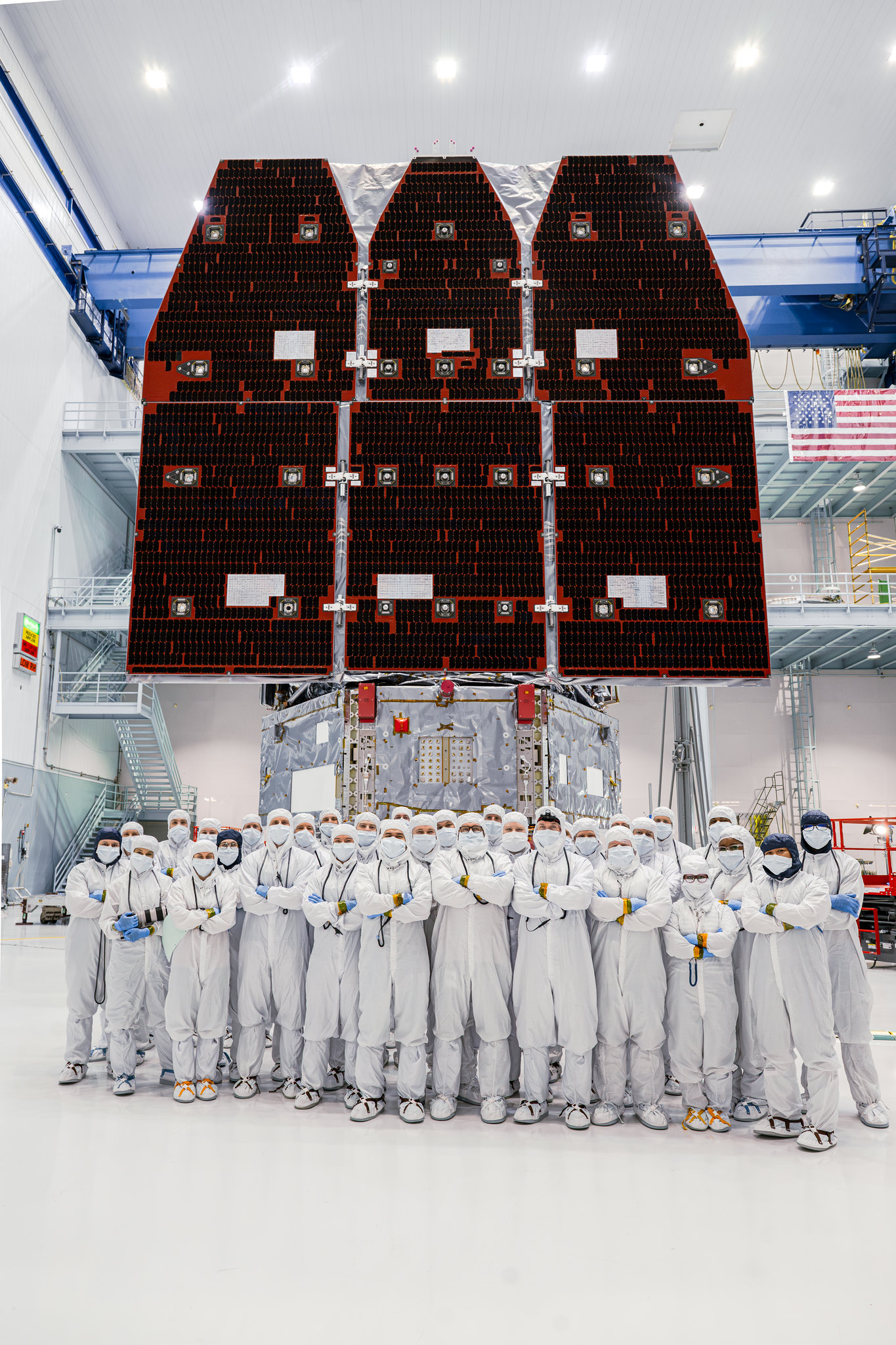
On Nov. 25, 2025, technicians joined the inner and outer segments together and the observatory was complete.
NASA / Sydney Rohde

What Will Scientists Study With the Nancy Grace Roman Space Telescope?

Scientists using the Nancy Grace Roman Space Telescope will focus on three main topic areas: dark energy, exoplanets, and dark matter.

Dark energy is a mysterious part of the universe. Scientists aren’t sure what it is, but it makes up about 68% of the universe’s total contents. It is believed to be responsible for the accelerating rate at which our universe is expanding. But recent observations seem to show that the pressure from dark energy is shifting over time. Scientists hope to use the Roman Space Telescope to help solve the mystery of dark energy’s true nature.

Exoplanets are planets outside of our solar system. Scientists have discovered more than 6,000 exoplanets. But they believe that billions could exist. Most of the exoplanets detected so far are wildly different than the planets in our solar system. Scientists expect Roman to find more unusual exoplanets. It will also allow astronomers to find planets in the habitable zone of their stars. This will be key to finding planets similar to Earth.

Dark matter is the invisible glue that holds the universe together. Scientists aren’t sure what dark matter is made of. Roman will allow scientists to peer back in time to trace how galaxies and galaxy clusters formed. If dark matter consists of heavy, sluggish particles, it would clump together readily and Roman should see galaxy formation early in cosmic history. If dark matter is made up of lighter, faster-moving particles, it should take longer to settle into clumps and for large-scale structures to develop. If astronomers can narrow down the candidates for dark matter particles, we’ll be one step closer to finally detecting them directly in experiments on Earth.

Who Was Nancy Grace Roman?

Nancy Grace Roman was NASA’s first chief astronomer and the first female executive at the agency. Roman championed the making of the first space-based telescope — the Hubble Space Telescope. She was involved in every crucial decision about the telescope from its funding to where it was built to the details of its instruments. Her vital role in making the project a reality led her to be known as “the mother of the Hubble Space Telescope.”

Roman was born May 16, 1925, in Nashville, Tennessee. She died Dec. 25, 2018.

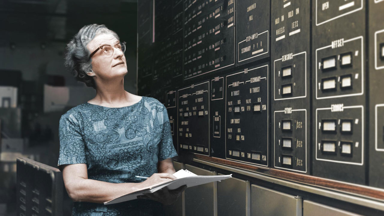
Portrait of astronomer Nancy Grace Roman holding papers and looking up at a board with information on it
Nancy Grace Roman was NASA’s first chief astronomer. She is knows as “the mother of the Hubble Space Telescope.”
NASA

Career Corner

More than a thousand technicians and engineers assembled Roman from millions of individual components. Here are a few examples of the careers that shaped NASA’s newest space telescope:

Instrument technician: These experts install, calibrate, and maintain sensors and control systems. They troubleshoot issues that might come up with delicate systems and equipment. This career path often starts with an apprenticeship or hands-on training alongside experienced technicians. An associate’s degree is often required.

Mechanical engineer: This branch of engineering focuses on complex machines and engines. Mechanical engineers design, build, test, and improve mechanical systems. They play an essential role in making a complex observatory like the Roman Space Telescope a reality. A career in engineering demands a strong understanding of math and complex problem-solving and usually requires an advanced college degree.

Astrophysicist: These scientists study the physics of the universe. They are interested in learning how the universe began, how it is evolving, and how it works. Becoming an astrophysicist requires advanced college degrees.

NASA also needs people who work in photography, management, social media, videography, and much more. Learn about some of the people who have made the Roman mission possible here!

More About the Nancy Grace Roman Space Telescope

Mission Website: Nancy Grace Roman Space Telescope

Video Game: Roman Space Observer

Roman Space Telescope Education and Outreach Materials

  •  

NASA Completes Astronaut-Deployed Science Instrument for Lunar Surface

Rectangular box-shaped device resting on a metal table. The front face is covered with a grid of many small black rectangular panels bordered in white. Metal components, brackets, and small box units are mounted along the top. The background shows a large windowed wall with a blurred American flag and an Artemis flag visible behind the device.
The fully-integrated LEMS (Lunar Environment Monitoring Station) ready for environmental testing. A small suitcase-size instrument suite built at NASA Goddard, LEMS is designed to carry out continuous, long-term monitoring of the seismic environment at the Moon, including surface motion caused by moonquakes and meteorite impacts in the lunar south polar region.
NASA Goddard/Mike Guinto

NASA has declared “wrenches down” on the first completed payload designed for Artemis astronauts to deploy on the Moon’s surface. Engineers working on NASA’s Lunar Environment Monitoring Station, or LEMS, have completed hardware development and testing and the payload is ready for its permanent home near the lunar South Pole. With the hardware complete, LEMS is ready to support one of the Artemis program’s core goals: enabling sustained lunar science and exploration.

The LEMS instrument package contains two highly sensitive seismometers that will monitor ground vibrations from moonquakes and meteorite impacts, providing scientists with insights into the Moon’s interior and the seismic hazards astronauts might encounter at the surface. Its modular design allows the system to be adapted or expanded to host new instruments in the future, creating a reusable platform that can evolve as scientific priorities grow.

The payload will remain in a clean room at NASA’s Goddard Space Flight Center in Greenbelt, Maryland, where it was built, until it is assigned to an Artemis mission for deployment to the lunar surface.

“The completion of the LEMS scientific instrument is a major step in a new era of lunar surface science. Innovative science experiments will uncover, measure, and reveal the Moon’s secrets while astronauts open new frontiers for discovery,” said Joel Kearns, deputy associate administrator for exploration, Science Mission Directorate, NASA Headquarters in Washington. “And, behind the scenes, countless teams across NASA and our partners are pushing the boundaries of what surface instruments can do, building the tools that will make future exploration possible and safer.”

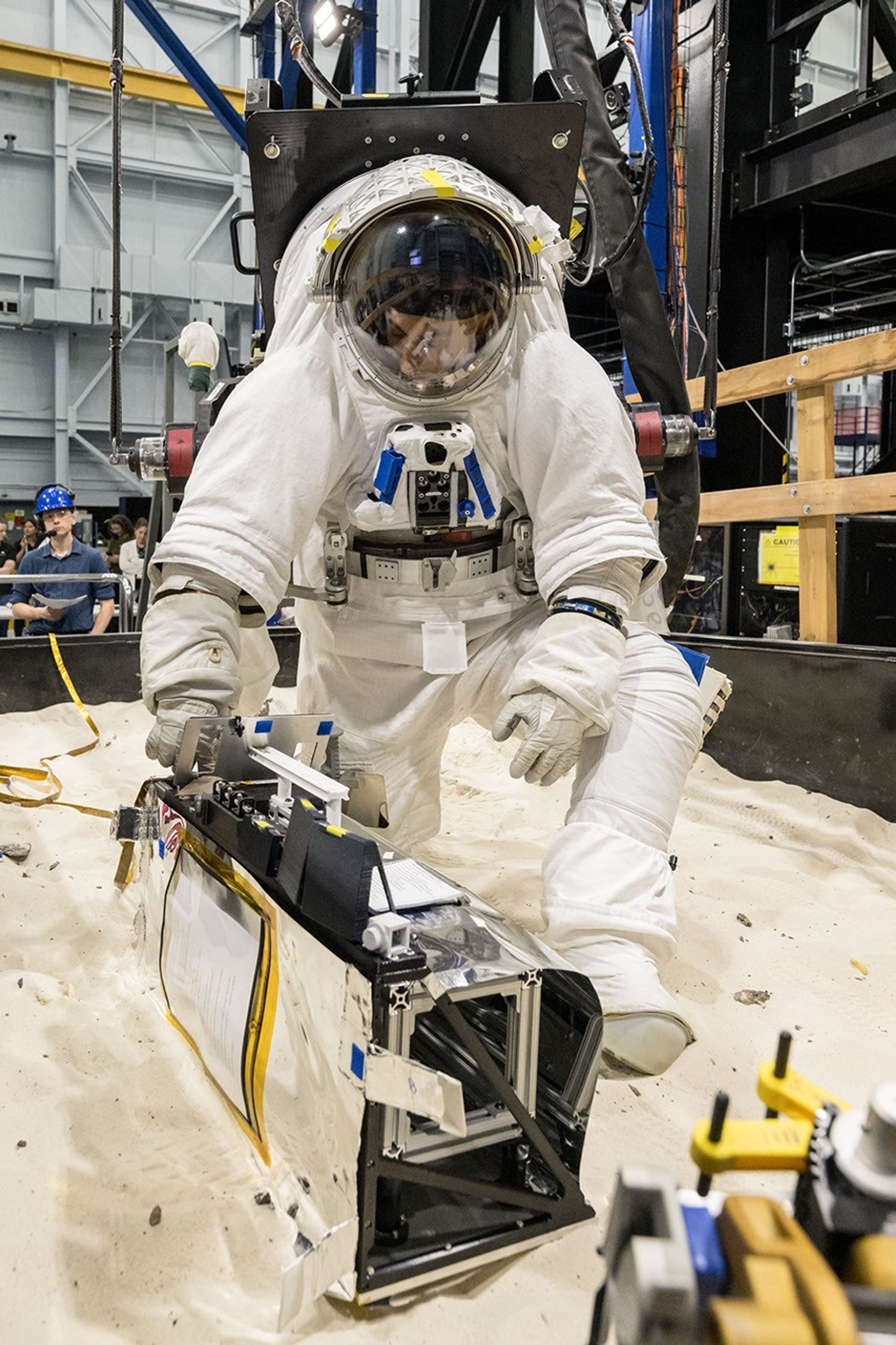
An astronaut in a white spacesuit kneels in simulated lunar soil while working with scientific equipment in a large testing facility. Staff members and support structures are visible in the background.
A scientist wearing NASA’s xEMU prototype space suit is testing the handling of a mockup version of NASA’s Lunar Environment Monitoring Station, or LEMS. The testing took place at the Active Response Gravity Offload System, a simulated reduced gravity environment at NASA’s Johnson Space Center in Houston.
NASA Johnson

The LEMS payload builds on a legacy of lunar seismic tracking. Apollo astronauts deployed a network of seismometers on the Moon’s nearside equatorial region between 1969 and 1972. Those instruments operated until 1977, recording about 13,000 moonquakes and other ground vibrations that helped scientists begin to understand the composition of the Moon’s interior. For decades, researchers have hoped to spread more seismometers, updated with new technologies, across the lunar surface.

Now, LEMS will carry the first seismometers to be deployed by future astronauts to listen for faint ground vibrations, collecting new clues to the Moon’s internal structure and ongoing seismic activity. The sensors will be the most compact, sensitive, and energy-efficient seismometers ever built for planetary exploration.

LEMS itself is about the size of a small suitcase, weighing 11 pounds in the Moon’s low-gravity environment. It will carry not just these seismic sensors, but everything it needs to function independently of humans after deployment. LEMS is built to manage its own power production via a lightweight, flexible solar array that conforms to the shape of the LEMS unit. It also will manage its operational activities to ensure continuous data collection based on a preset plan, and monthly data transmission to Earth. The payload will do all this while maintaining a stable internal temperature throughout the massive day-to-night temperature swings of the South Pole region.

A technician in a white clean-room suit and blue gloves uses a small flashlight to inspect a spacecraft instrument inside a dark testing chamber. Colorful wires and metallic components surround the instrument.
Mechanical Engineer Brie Ludwig inspects the Lunar Environment Monitoring Station (LEMS) in preparation for testing in a thermal vacuum chamber at Goddard Space Flight Center in Greenbelt, Maryland, on March 31, 2026. LEMS is a compact, autonomous, and self-sustaining seismometer suite designed to carry out continuous, long-term monitoring of the lunar seismic environment at the South Polar region.
NASA/Denny Henry

“When we conceived of LEMS, we weren’t just thinking about the next mission, we were thinking about the next generation of lunar exploration,” said Mehdi Benna, a University of Maryland Baltimore County scientist who leads LEMS from NASA Goddard. “Our vision was to create a scientific buoy for the Moon. Like an ocean buoy on Earth, LEMS is designed to be easy to build, adaptable to different scientific objectives, and capable of operating independently for years.”

Before any surface science could happen, Benna and his team had to ensure that LEMS could survive the trip to the Moon and the harsh environment of its surface. Over the past five months, LEMS and its components have been subjected to a demanding series of environmental and operational tests. Engineers verified LEMS can endure the violent shaking of launch, the journey to the lunar surface, and the Moon’s temperature and radiation environment. The team also showed that the instrument package’s mechanical and electrical design is safe for astronaut handling.

The LEMS payload was built to operate through the lunar night, which lasts two Earth weeks, without external power assistance or a heat source. Past lunar surface instruments relied on radioisotope heaters for warmth and power. But LEMS instead will withstand temperatures that dip to minus 400 degrees Fahrenheit in some areas by using advanced insulation materials, low-thermal-conductivity cables that minimize heat loss, and a thermal regulator that conducts heat away during the day to prevent overheating and helps retain heat at night.

These innovations reduce mass and power needs, setting the stage for lighter, energy-efficient instruments that can operate continuously at future Artemis landing sites and the NASA-led Moon Base.

The LEMS payload is led by University of Maryland Baltimore County and University of Maryland College Park. Technical implementation is led by NASA Goddard. The University of Arizona, in partnership with Silicon Audio, Inc., supplied LEMS’ two state-of-the-art seismometers. Morehead State University in Kentucky provided LEMS’ telecommunication system and will operate the instrument on the surface. Washington University in St. Louis will manage the instrument’s data processing and dissemination to the larger scientific community.

  •  

Lion Nebula Roars in Webb’s Sights

JWST’s Near Infrared Camera and Mid Infrared Instrument combined image of planetary nebula NGC 2392, the Lion Nebula, against the black background of space. The nebula is at center, circular in shape, and looks like a male lion’s head. In the center is a small, pinkish-white circle with eight-point diffraction spikes, a white dwarf star. Surrounding the star are purple-pink cavernous bubbles and shell-like rings. The bubbles and shells collectively form an oval with two small, wide arcs near the top, reminiscent of a lion’s face and its ears. What appears to be extended outward from the lion’s face is a thick ring of purple-blue material. The width of the ring is consistent throughout and resembles a mane. The area closest to the lion’s face looks cloudy, while the edges of the mane look like there are clumps of dust with comet-like tails. In the background are distant galaxies and stars. Some galaxies are yellow and orange points of light and others have spiral structures. Some stars have diffraction spikes.
NASA’s James Webb Space Telescope imaged the planetary nebula NGC 2392, the Lion Nebula, using the observatory’s NIRCam and MIRI instruments. The central star’s remains are responsible for the nebula’s structure, including a lion face-shaped bubble of ionized gas and dust “mane.”
Image: NASA, ESA, CSA, STScI; Image Processing: Alyssa Pagan (STScI)

Observing across the starry “plains” of space, NASA’s James Webb Space Telescope has taken new images of NGC 2392, nicknamed the Lion Nebula. The nebula’s “mane” is clear and detailed in this image released on Aug. 10, 2026, due to Webb’s high-resolution imaging.

See more images of the Lion Nebula from Webb.

Image: NASA, ESA, CSA, STScI; Image Processing: Alyssa Pagan (STScI)

  •  

NASA Telescopes Create Colorful ‘Craft’ From Nearby Nebula

4 Min Read

NASA Telescopes Create Colorful ‘Craft’ From Nearby Nebula

This multiwavelength image of the Tarantula Nebula, one of the brightest and largest regions of star formation to Earth, shows X-rays from Chandra that reveal gas that has been blown away in winds from the surfaces of young, massive stars and heated to millions of degrees by shock waves, like sonic booms from supersonic jets. The infrared data from Webb shows thousands of young stars, plus swaths of cool dust that will provide the ingredients to one day form new stars and planets. Hubble optical data uncovers hydrogen gas that is warmer than seen with Webb, as well as some individual stars through the nebula.

Like a collage made of layered sheets of colored cellophane, a vibrant new image layers observations of a famous star-forming nebula from NASA space telescopes. The resulting cosmic “craft” reveals new details about the star formation region known as 30 Doradus, or the Tarantula Nebula.

Located in the Large Magellanic Cloud, a small neighbor galaxy to the Milky Way about 160,000 light-years from Earth, the Tarantula has thousands of young stars embedded in a vibrant honeycomb-like structure of gas and dust.

This multiwavelength image of the Tarantula Nebula, one of the brightest and largest regions of star formation to Earth, shows X-rays from Chandra that reveal gas that has been blown away in winds from the surfaces of young, massive stars and heated to millions of degrees by shock waves, like sonic booms from supersonic jets. The infrared data from Webb shows thousands of young stars, plus swaths of cool dust that will provide the ingredients to one day form new stars and planets. Hubble optical data uncovers hydrogen gas that is warmer than seen with Webb, as well as some individual stars through the nebula.
X-ray: NASA/CXC/Ohio State Univ./J. Rodriguez et al; Infrared: NASA/ESA/CSA/STScI; Optical: NASA/ESA/STScI; Image Processing: NASA/CXC/SAO/P. Edmonds

Like a collage made of layered sheets of colored cellophane, a vibrant new image layers observations of a famous star-forming nebula from NASA space telescopes. The resulting cosmic “craft” reveals new details about the star formation region known as 30 Doradus, or the Tarantula Nebula.

Located in the Large Magellanic Cloud, a small neighbor galaxy to the Milky Way about 160,000 light-years from Earth, the Tarantula has thousands of young stars embedded in a vibrant honeycomb-like structure of gas and dust.

The new composite image contains X-rays from NASA’s Chandra X-ray Observatory, which has repeatedly observed the Tarantula Nebula over the course of its mission, in the layer that appears in blue. The X-ray data reveals gas blown away by winds from the surfaces of young, massive stars and heated to millions of degrees by shock waves, like sonic booms from supersonic jets.

The red represents infrared data from NASA’s James Webb Space Telescope showing thousands of young stars, plus swaths of cool dust that will provide the ingredients to form new stars and planets. Optical data in the green layer from NASA’s Hubble Space Telescope uncovers hydrogen gas that is warmer than seen with Webb, as well as some individual stars through the nebula.

The composite image shows the full Hubble and Webb images of this region, as well as a large section of the Chandra image, all recently published in a research paper in the Astrophysical Journal. In some regions the blue Chandra layer stands alone, and in others it combines with either the red Webb data or the green Hubble data. In the middle region all three images overlap to provide a holistic view in red, orange, yellow, green, and blue.

Previously, astronomers had studied the amount and the impact of energy produced by winds from young, massive stars in the Tarantula Nebula. Scientists expect that much of this energy should heat gas so that it produces X-rays. However, the research paper shows that there is much less X-ray-emitting gas in the nebula than expected. This led researchers to ask: Where has this energy gone and what tamed the Tarantula Nebula?

By studying the data from Chandra, Hubble, and Webb, combined with data from NASA’s retired Spitzer Space Telescope, the team concluded the Tarantula may be losing energy from several sources.

First, up to half of the hot gas is leaking through the shell walls of the gas and dust structures and escaping the nebula. Next, there is stirring and mixing between the cold gas near the shell walls and some of the hot gas, lowering the overall temperature of the gas. Finally, comparisons with computer simulations suggest the Tarantula may be losing energy through conduction. This involves direct physical contact between hot and cooler material, like with a frying pan on a burner, causing the hot and cooler material to equalize in temperature. In the case of the Tarantula Nebula, the hot gas would be conducting heat by being in direct contact with the cooler gas in the shells, especially in the densest regions. This scenario does not necessarily involve mixing the hot and cooler gas.

The combination of these three channels for losing large amounts of energy leads to this colorful and complex display revealed by NASA’s telescopes working together.

This multiwavelength image of the Tarantula Nebula, one of the brightest and largest regions of star formation to Earth, shows X-rays from Chandra that reveal gas that has been blown away in winds from the surfaces of young, massive stars and heated to millions of degrees by shock waves, like sonic booms from supersonic jets. The infrared data from Webb shows thousands of young stars, plus swaths of cool dust that will provide the ingredients to one day form new stars and planets. Hubble optical data uncovers hydrogen gas that is warmer than seen with Webb, as well as some individual stars through the nebula.
Tarantula Nebula / 30 Doradus, cropped version.
X-ray: NASA/CXC/Ohio State Univ./J. Rodriguez et al; Infrared: NASA/ESA/CSA/STScI; Optical: NASA/ESA/STScI; Image Processing: NASA/CXC/SAO/P. Edmonds

The paper describing these results was led by Jennifer Rodriguez of The Ohio State University in Columbus. Additional authors on the paper include Laura Lopez, Ohio State; Lachlan Lancaster, Columbia University in New York City; Anna Rosen, San Diego State University; Omnaraynai Nayak, Space Telescope Science Institute in Baltimore; Sebastian Lopez, Ohio State; Tyler Holland-Ashford, NASA’s Goddard Space Flight Center in Greenbelt, Maryland; and Trinity Webb, Ohio State.

NASA’s Marshall Space Flight Center in Huntsville, Alabama, manages the Chandra program. The Smithsonian Astrophysical Observatory’s Chandra X-ray Center controls science operations from Cambridge, Massachusetts, and flight operations from Burlington, Massachusetts.

To learn more about Chandra, visit:

https://nasa.gov/chandra

About the Author

Megan Watzke

Share

Details

Last Updated
Aug 12, 2026
Editor
Lee Mohon
Contact
Megan Watzke
Location
Marshall Space Flight Center
  •  

Building the Moon Base: NASA Stories at the Ion  

4 Min Read

Building the Moon Base: NASA Stories at the Ion  

Shatel Bhakta, principal systems engineer for NASA’s Moon Base Program, gives a presentation during NASA Stories at the Ion in Houston on July 30, 2026.
Credits: NASA/Sumer Loggins
Shatel Bhakta, principal systems engineer for NASA’s Moon Base Program, gives a presentation during NASA Stories at the Ion in Houston on July 30, 2026.
NASA/Sumer Loggins

As NASA prepares to return astronauts to the lunar surface for longer stays and increasingly complex operations, building the Moon Base will require new ideas, advanced technologies, and expertise across many fields. 

During NASA Stories at the Ion on July 30, Shatel Bhakta, principal systems engineer for NASA’s Moon Base Program, presented “Building the Moon Base: Challenges and Opportunities at the Lunar South Pole.” He discussed the work required to establish a sustained human presence at the Moon. 

Through its growing partnership with Rice University and the Ion, NASA’s Johnson Space Center in Houston hosts recurring talks connecting agency experts with entrepreneurs, researchers, students, and industry leaders. The series gives Houston’s innovation community a closer look at the people and ideas shaping the future of exploration.  

Shatel Bhakta, principal systems engineer for NASA’s Moon Base Program, presents during NASA Stories at the Ion. At left is Laura Neder, head of platform for the Rice Alliance for Technology and Entrepreneurship and the Ion District. 
NASA/Sumer Loggins

Laura Neder, head of platform for the Rice Alliance for Technology and Entrepreneurship and the Ion District, welcomed attendees and introduced Monte Goforth, acting director of Business Development and Technology Integration at Johnson. Goforth delivered opening remarks on the value of sharing NASA’s work beyond the agency and bringing people together to support future exploration before introducing Bhakta. 

Bhakta outlined how NASA is working toward long-duration human exploration of the lunar South Pole through the agency’s Moon Base Program. 

As part of that effort, NASA is taking a step-by-step approach to Moon Base development. Early robotic missions and technology demonstrations will help NASA gather data about the lunar environment, test systems, and reduce risks before expanding infrastructure and human operations.  

“This is probably going to be the most challenging endeavor NASA has ever undertaken,” Bhakta said.  

Meeting that challenge will require collaboration between NASA and its commercial and international partners to develop solutions for operating in extreme environmental conditions.  

Unlike the Apollo landing sites, areas near the lunar South Pole contain steep slopes, deep craters, and lighting conditions that change throughout the year. The Sun remains low on the horizon, creating shifting shadows that can complicate navigation and leave solar panels without sunlight for extended periods, increasing the need for energy storage and other power sources. 

Because of the region’s rugged terrain, crews, rovers, and other surface systems may not always have a clear line of sight to Earth. NASA will need communications infrastructure to relay signals across the lunar South Pole. 

Bhakta explained that Moon Base may not be a single cluster of connected structures. Terrain, lighting, power, and landing constraints could require habitats and other systems to be distributed across the lunar surface. 

Attendees listen as Shatel Bhakta, principal systems engineer for NASA’s Moon Base Program, discusses the challenges of establishing a sustained human presence at the Moon.
NASA/Sumer Loggins

Lunar regolith, or Moon dust, remains one of the greatest challenges. Without mitigation, the sharp and clingy substance could damage equipment and spacesuits while posing health risks to astronauts. Its electrostatic properties can also change depending on lighting and environmental conditions. 

Understanding how lunar regolith behaves will be essential to ensuring crews can safely live and work on the lunar surface. 

Some permanently shadowed regions near the lunar South Pole may not have received direct sunlight for billions of years and may contain water ice and other volatile materials. These resources could support future exploration, but using them will require new mobility, power, and processing systems. 

The Moon will also serve as a proving ground for missions farther into the solar system. Operating on the lunar surface will help NASA learn how crews, equipment, and infrastructure perform away from Earth before future human missions to Mars. 

As NASA develops these capabilities, Bhakta explained that keeping the Moon Base architecture adaptable will require understanding how individual systems connect and work together. 

“Don’t deal with the technology directly,” Bhakta said. “Deal with the interfaces.” 

From left, Monte Goforth, acting director of Business Development and Technology Integration at NASA’s Johnson Space Center; Shatel Bhakta, principal systems engineer for NASA’s Moon Base Program; and Laura Neder, head of platform for the Rice Alliance for Technology and Entrepreneurship and the Ion District, pose during NASA Stories at the Ion.
NASA/Sumer Loggins

Building the Moon Base will take more than engineers and scientists. NASA will need communicators, business professionals, researchers, and people from many other fields to help solve problems and share the agency’s work. 

“There are many ways to contribute,” Bhakta said. “Don’t be afraid that your skill set does not fit in.” 

Moon Base build-up will offer multiple entry points for industry and international collaborators to participate, innovate, and contribute. From early demonstrations to long-term surface operations, there are multiple solicitations currently open.  

Find more information at:

www.nasa.gov/moonbase-solicitations

About the Author

Sumer Loggins

Sumer Loggins

Share

Details

Last Updated
Aug 11, 2026
Keep Exploring

Discover More Topics From NASA

  •  
❌