Canicules, incendies et océans en surchauffe. Derrière ces crises en apparence distinctes, les scientifiques voient un même signal : une Terre dont les mécanismes de protection subissent une pression sans précédent.
Although the famous Carrington Event of 1859 is often described as the first major space weather event to affect technology, earlier incidents did occur. Historical records show that telegraph systems were disrupted by geomagnetic storms as early as the late 1840s.
Through ROSES-25 A.14 Atmosphere NASA is soliciting proposals for data analysis and modeling of NASA supported airborne campaign data. NASA’s Earth Science Division has supported numerous airborne campaigns during the last few years, see Section 2 of the program element text.
A.14 Atmosphere required a mandatory Notice of Intent (NOI) to propose. Proposers who have not already submitted a compliant NOI are not eligible to submit a proposal.
ROSES-2025 Amendment 74 delays the due date for A.14 Atmosphere to December 2, 2026. Also, Section 4.3.3 “Use of Generative AI” now mentions a related NSPIRES cover page question on the use of AI. An updated FAQ has been posted under “Other Documents” on the NSPIRES page for this program element.
La couche d’ozone, notre bouclier naturel contre les ultraviolets, va mieux. Pourtant, en Europe, les UV gagnent du terrain. Une apparente contradiction qui raconte une autre transformation de notre atmosphère.
Mis en orbite en mars 2025, UVSQ-SAT NG a été développé au Latmos (Laboratoire Atmosphères et Observations spatiales – CNRS, Sorbonne Université, UVSQ), avec de nombreux partenaires académiques et industriels. Ce nanosatellite poursuit une démarche engagée avec les missions qui l’ont précédé :...
Researchers at the Karlsruhe Institute of Technology (KIT) in Germany and Stanford University in the US have developed an energy-collecting device that can simultaneously cool, produce electricity and generate heat. In their prototype, a radiative cooling layer reached 6.5 °C below ambient temperature while a solar collector generated electricity and reached nearly 111 °C.
“The new system could be installed on the roofs and facades of buildings to provide these three energy services at once,” says Gan Huang, who is head of the Hybrid Solar Technologies lab at KIT. “It could also be attractive for AI data centres that need both intensive power and cooling at the same time.”
As many of us have experienced, summer in the northern hemisphere has been particularly hot this year – a situation that is only likely to worsen in the future as the effects of climate change take hold. With this warming will come the increased need for air conditioning to cool down buildings. The problem is that current compression-based systems consume a lot of electricity and produce large amounts of CO2.
Passive daytime radiative cooling
A potential alternative is passive daytime radiative cooling (PDRC), in which heat is continuously exchanged between objects at different temperatures by absorbing and emitting thermal radiation. When the heat absorbed by the material is less than the energy radiated to outer space, it can cool down during the day – even without electricity.
Our planet naturally experiences this effect by radiating heat out to space. This allows it to cool down at night because its temperature (of around 300 K) is much higher than that of outer space (around 3 K) and there is no incident solar irradiation from the Sun at night.
A good PDRC material needs to satisfy several criteria. For one, it must reflect sunlight strongly at solar spectrum wavelengths (of 0.3 to 2.5 µm) to avoid it heating up. It also needs to emit heat strongly in the long-wave infrared (LWIR) wavelengths (of 8–13 µm) where the atmosphere is more transparent to infrared radiation, so that it can lose energy to the cold sky. Over the past decade, researchers have succeeded in developing a wide range of PDRC materials, including multilayer nanophotonic emitters, single-layer polymers on reflectors and porous ceramics. However, conventional PDRC systems cannot harvest the coldness of outer space and solar energy from the same surface at the same time.
A hybrid PDRC and photovoltaic-thermal collector
In the new work, which is detailed in Cell Reports Physical Science, the KIT researchers made a hybrid PDRC and photovoltaic-thermal collector. The emitting layer in the device, which is transparent, consists of a silica substrate coated with the silicone polymer polydimethylsiloxane. This layer allows sunlight to pass through while simultaneously emitting heat as LWIR radiation through the atmospheric window. Beneath the transparent emitter, a Fresnel lens concentrates the transmitted sunlight onto the (gallium arsenide-based) photovoltaic-thermal collector mounted on a two-axis solar tracker. This is where electricity is generated.
In outdoor experiments performed during the day, the prototype simultaneously achieved cooling of up to 6.5 °C below ambient temperature, an electrical power density of 60.6 W/m² and heating up to 110.8 °C. “This is exciting,” says Huang, “because it shows that the hot Sun and the cold universe can be harvested together, rather than treated as separate resources as has been the case until now.”
The main challenge was ensuring that the solar collector became hot while the radiative cooler stayed cool, he explains. “We achieved this by concentrating the transmitted sunlight onto a much smaller solar collector underneath the transparent cooling layer, so reducing thermal interference between the hot and cold parts in the device.”
The team is now busy improving the efficiency and practical design of its system. “We are already working on a better optical design, improved thermal management and more efficient solar cells,” reveals Huang.
“The Sun is not the only renewable energy resource in the sky, the coldness of outer space is another,” he says. “We believe there are many exciting possibilities for a new generation of energy systems if we learn how to manage both these together.”
How 2 US, European Satellites Are Studying Hurricanes During El Niño
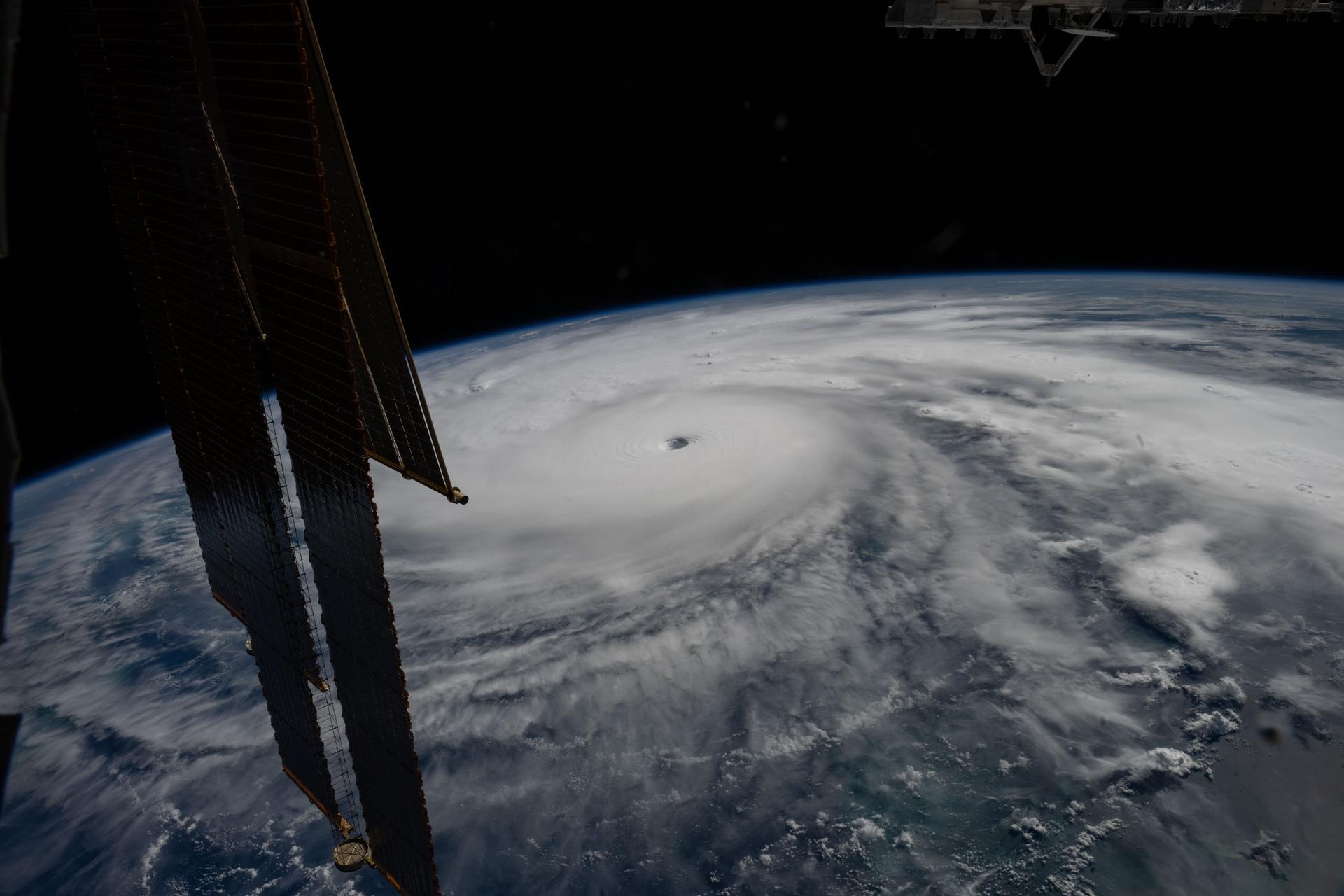
Hurricane Melissa is seen 50 miles south of Jamaica in this photograph taken from the International Space Station on Oct. 28, 2025.
NASA
Last November, NASA and its European partners launched the Sentinel-6B satellite to improve hurricane forecasts, help protect infrastructure, and benefit commercial industries, including shipping. The satellite now is flying 30 seconds behind its predecessor, Sentinel-6 Michael Freilich. Both satellites are providing precise sea level height measurements during what oceanographers expect to be a historic El Niño, a naturally occurring oceanic phenomenon in which warmer-than-usual Pacific waters shift global weather patterns.
The two satellites make up the Copernicus Sentinel-6/Jason-CS (Continuity of Service) mission, the latest in a series of ocean-observing radar altimetry missions that have been monitoring Earth’s changing seas continuously since the early 1990s.
The data each satellite is collecting will not only allow scientists to better understand this year’s El Niño but will also help them create more accurate hurricane predictions.
“This El Niño was a late-bloomer,” said Josh Willis, Sentinel-6B’s project scientist at NASA’s Jet Propulsion Laboratory in Southern California. “It didn’t kick off until the middle of the year and is just now reaching a strength similar to what we’ve seen in the satellite record during significant El Niños in 1997 and 2015. We expect it to be big, and it’s already having big impacts.”
El Niños generally scramble weather patterns tied to rainfall and storms, including hurricanes. They also redistribute heat in the ocean, which affects sea level. Normally, Earth’s warmest ocean waters sit along the equator in the western Pacific. During El Niño, weakened winds, which usually blow westward along the equator, result in heat spreading east toward South America. The change in ocean heat shifts hurricane activity from the Atlantic to the Pacific Ocean.
Predicting hurricane strength
On July 15, Sentinel-6B began delivering low-latency data to scientists that could be used for weather predictions. That data will take some time to work its way into the research models on which meteorologists and climate scientists rely, but when it does, those improved models could save lives.
Data from Sentinel-6 satellite missions feeds into hurricane tracking algorithms used by federal and state agencies. Those predictions can activate disaster response efforts, mobilizing resources ranging from sandbag placement to National Guard activation. They also can lead to evacuation orders that require quick but well-informed decisions about logistics at a local level. More severe events may require engaging larger organizations, such as the Federal Emergency Management Agency.
A tropical storm can take a week or more to become a hurricane and make its way to a coastline, but a hurricane can rapidly intensify in the 48 hours prior to landfall, leaving planners little time to prepare.
“Hurricanes have been known to speed up quickly at the last moment, so the window in which to decide what to do is short,” said Deirdre Byrne, an oceanographer and altimetry expert with the National Oceanic and Atmospheric Administration (NOAA). “The goal is to forecast how much and how rapidly intensification will happen so that officials can make the right calls.”
Each Sentinel-6 satellite measures ocean height, as well as the size of waves and marine wind speed, using a radar altimeter, which bounces thousands of radar pulses a second off the crests and troughs of waves. Ocean height varies from place to place and provides insight into the ocean’s heat content, since warm water expands. That, in turn, helps forecast how fast hurricanes will grow.
Among the measurements Sentinel-6 is gathering, Byrne is most anticipating the ocean height data, which she plans to begin incorporating into the current Satellite Ocean Heat Content Suite algorithm by the end of the year.
“In terms of data quality, the Sentinel-6 missions are unparalleled,” Byrne said.
Together, the missions are also extending a precise dataset deep into its fourth decade. This record of sea level observations traces back to the TOPEX/Poseidon mission, which launched in 1992, and continues through to the present day with Sentinel-6 Michael Freilich. Sentinel-6B will take over for its predecessor as the reference satellite for global sea level measurements later this year.
“The key is consistency, measuring the same way, every time,” said Severine Fournier, Sentinel-6B deputy project scientist, JPL. “That’s what lets us predict hurricanes, and, in turn, protect coastal communities and infrastructure.”
More about Sentinel-6B
Sentinel-6 Michael Freilich, named after a former director of NASA’s Earth Science Division, is one of two satellites that compose the Copernicus Sentinel-6/Jason-CS mission.
Sentinel-6/Jason-CS, a part of the European Union’s Earth observation program called Copernicus, was jointly developed by ESA (European Space Agency), EUMETSAT (European Organisation for the Exploitation of Meteorological Satellites), NASA, and NOAA, with funding support from the European Commission and technical support on performance from the French space agency CNES (Centre National d’Études Spatiales). Spacecraft monitoring and control, as well as the processing of all the altimeter science data, is carried out by EUMETSAT on behalf of the European Union’s Copernicus Programme, with the support of all partner agencies.
NASA JPL, a division of Caltech in Pasadena, contributed three science instruments for each Sentinel-6 satellite: the Advanced Microwave Radiometer, the GNSS-RO, and the Laser Retroreflector Array. NASA also contributed launch services, ground systems supporting operation of the agency’s science instruments, the science data processors for two of these instruments, and support for the United States members of the international Ocean Surface Topography Science Team.
Preparations for Next Moonwalk Simulations Underway (and Underwater)
Hurricane Melissa is seen 50 miles south of Jamaica in this photograph taken from the International Space Station on Oct. 28, 2025.
NASA
Last November, NASA and its European partners launched the Sentinel-6B satellite to improve hurricane forecasts, help protect infrastructure, and benefit commercial industries, including shipping. The satellite now is flying 30 seconds behind its predecessor, Sentinel-6 Michael Freilich. Both satellites are providing precise sea level height measurements during what oceanographers expect to be a historic El Niño, a naturally occurring oceanic phenomenon in which warmer-than-usual Pacific waters shift global weather patterns.
The two satellites make up the Copernicus Sentinel-6/Jason-CS (Continuity of Service) mission, the latest in a series of ocean-observing radar altimetry missions that have been monitoring Earth’s changing seas continuously since the early 1990s.
The data each satellite is collecting will not only allow scientists to better understand this year’s El Niño but will also help them create more accurate hurricane predictions.
“This El Niño was a late-bloomer,” said Josh Willis, Sentinel-6B’s project scientist at NASA’s Jet Propulsion Laboratory in Southern California. “It didn’t kick off until the middle of the year and is just now reaching a strength similar to what we’ve seen in the satellite record during significant El Niños in 1997 and 2015. We expect it to be big, and it’s already having big impacts.”
El Niños generally scramble weather patterns tied to rainfall and storms, including hurricanes. They also redistribute heat in the ocean, which affects sea level. Normally, Earth’s warmest ocean waters sit along the equator in the western Pacific. During El Niño, weakened winds, which usually blow westward along the equator, result in heat spreading east toward South America. The change in ocean heat shifts hurricane activity from the Atlantic to the Pacific Ocean.
Predicting hurricane strength
On July 15, Sentinel-6B began delivering low-latency data to scientists that could be used for weather predictions. That data will take some time to work its way into the research models on which meteorologists and climate scientists rely, but when it does, those improved models could save lives.
Data from Sentinel-6 satellite missions feeds into hurricane tracking algorithms used by federal and state agencies. Those predictions can activate disaster response efforts, mobilizing resources ranging from sandbag placement to National Guard activation. They also can lead to evacuation orders that require quick but well-informed decisions about logistics at a local level. More severe events may require engaging larger organizations, such as the Federal Emergency Management Agency.
A tropical storm can take a week or more to become a hurricane and make its way to a coastline, but a hurricane can rapidly intensify in the 48 hours prior to landfall, leaving planners little time to prepare.
“Hurricanes have been known to speed up quickly at the last moment, so the window in which to decide what to do is short,” said Deirdre Byrne, an oceanographer and altimetry expert with the National Oceanic and Atmospheric Administration (NOAA). “The goal is to forecast how much and how rapidly intensification will happen so that officials can make the right calls.”
Each Sentinel-6 satellite measures ocean height, as well as the size of waves and marine wind speed, using a radar altimeter, which bounces thousands of radar pulses a second off the crests and troughs of waves. Ocean height varies from place to place and provides insight into the ocean’s heat content, since warm water expands. That, in turn, helps forecast how fast hurricanes will grow.
Among the measurements Sentinel-6 is gathering, Byrne is most anticipating the ocean height data, which she plans to begin incorporating into the current Satellite Ocean Heat Content Suite algorithm by the end of the year.
“In terms of data quality, the Sentinel-6 missions are unparalleled,” Byrne said.
Together, the missions are also extending a precise dataset deep into its fourth decade. This record of sea level observations traces back to the TOPEX/Poseidon mission, which launched in 1992, and continues through to the present day with Sentinel-6 Michael Freilich. Sentinel-6B will take over for its predecessor as the reference satellite for global sea level measurements later this year.
“The key is consistency, measuring the same way, every time,” said Severine Fournier, Sentinel-6B deputy project scientist, JPL. “That’s what lets us predict hurricanes, and, in turn, protect coastal communities and infrastructure.”
More about Sentinel-6B
Sentinel-6 Michael Freilich, named after a former director of NASA’s Earth Science Division, is one of two satellites that compose the Copernicus Sentinel-6/Jason-CS mission.
Sentinel-6/Jason-CS, a part of the European Union’s Earth observation program called Copernicus, was jointly developed by ESA (European Space Agency), EUMETSAT (European Organisation for the Exploitation of Meteorological Satellites), NASA, and NOAA, with funding support from the European Commission and technical support on performance from the French space agency CNES (Centre National d’Études Spatiales). Spacecraft monitoring and control, as well as the processing of all the altimeter science data, is carried out by EUMETSAT on behalf of the European Union’s Copernicus Programme, with the support of all partner agencies.
NASA JPL, a division of Caltech in Pasadena, contributed three science instruments for each Sentinel-6 satellite: the Advanced Microwave Radiometer, the GNSS-RO, and the Laser Retroreflector Array. NASA also contributed launch services, ground systems supporting operation of the agency’s science instruments, the science data processors for two of these instruments, and support for the United States members of the international Ocean Surface Topography Science Team.
Researchers developed a model showing how lava-covered planets close to their stars can hold onto their atmospheres, which could help guide the search for life beyond our solar system. Some planets orbit so close to their stars that intense radiation should strip away their atmospheres. Yet several of these scorching, lava-covered worlds still retain thick [...]
For almost five decades, Saturn’s north pole has been famous for hosting a bizarre, six-sided jet stream known as the hexagon, a feature first spotted by NASA’s Voyager spacecraft in the 1980s and still churning today.
A new theoretical kind of extraterrestrial life could survive the harsh acid clouds of Venus, according to MIT researchers.
Despite longstanding conceptions that Venus would be too deadly for even the hardiest of extremophiles, new evidence suggests a rethinking of life from the ground up may be in order. The work was revealed in a recent paper published in the Proceedings of the National Academy of Sciences, which describes how extraterrestrial life could form from peptides to thrive only in such a hostile environment.
Based on recent evidence, it may be time to cast a wider net in the search for extraterrestrial life and look at planets that bear little resemblance to Earth.
The Brutal Venusian Environment
“We really don’t know the full extent of what planet archetypes are out there,” said senior co-author Sara Seager, the Class of 1941 Professor of Planetary Sciences in the Department of Earth, Atmospheric and Planetary Sciences and a professor at MIT’s departments of Physics and of Aeronautics and Astronautics. “We’re seeking exoplanets that might be a true Earth twin, but what if they’re all Venuses? Our findings definitely open up a whole range of possibilities.”
About 30 to 40 miles above Venus’s scorching surface, which reaches temperatures close to 900° F, lies a pocket of milder temperatures that some scientists think may be conducive to life. However, this region’s heavy cloud cover poses its own challenges. Instead of being composed primarily of water, the clouds on Venus are 98% sulfuric acid, which is strong enough to dissolve metals and would kill any known life on Earth.
While traditional astrobiological thinking held that this would be far too extreme for complex biological molecules to hold together, new evidence is overturning that idea. Recent work at MIT suggests that peptides can endure such challenging conditions, maintaining their stability and adopting shapes useful to biological processes.
“If peptides find their way to that cloud layer of concentrated sulfuric acid, they will stay and be stably preserved in that cloud of droplets,” said senior co-author Mei Hong, an MIT professor of chemistry and one of the senior authors of the new study. “And once these macromolecules have a defined three-dimensional structure, they can potentially have a function.”
Seeding Extraterrestrial Life
Following the concept of panspermia, which holds that the building blocks of life are transmitted throughout the universe on meteoroids, asteroids, and comets, the researchers investigated whether any building blocks could survive the Venusian conditions to give rise to extraterrestrial life.
Work began in Seager’s lab in 2020, studying how biological molecules could endure the stress of such an acidic environment. With nuclear magnetic resonance spectroscopy, they analyzed the structures of molecules in sulfuric acid solution. Surprisingly, nucleic acids, lipids, and amino acids all maintained their integrity under acidic conditions.
The next step was to investigate whether peptides could likewise hold their integrity and also assume useful biological shapes. They were surprised to find how resilient the peptides were, holding on for weeks at a time. Ironically, the lack of water in the environment could be a blessing, as without it, the hydrolysis reaction that breaks down peptides cannot occur.
“Without water, an acid that you would consider a harsh solvent suddenly is not as menacing as one might think,” Hong said.
New Concepts in Extraterrestrial Life
Additionally, the sulfuric acid molecules acted as scaffolds, allowing biologically useful shapes to form that otherwise wouldn’t, such as omega loops, which are found in some naturally occurring proteins on Earth but not typically in peptides.
“What hadn’t been known is that peptides can survive so well and have specific three-dimensional shapes in an acidic environment,” Hong explained.
Follow-up work will take these ideas even further, synthesizing a DNA alternative called PNA, made from peptides. Their existing work shows that a single PNA strand is stable in sulfuric acid, but the new research will attempt to recreate DNA’s double-strand structure with peptides. They also plan to investigate whether long peptides can hold omega loops under these acidic conditions.
Based on their results, extraterrestrial life could easily be hiding in environments highly divergent from anything seen on Earth. Continued investigation may reveal that rather than being poisonous, environments like Venus may be the only places certain lifeforms could exist.
Ryan Whalen covers science and technology for The Debrief. He holds an MA in History and a Master of Library and Information Science with a certificate in Data Science. He can be contacted at ryan@thedebrief.org, and follow him on Twitter @mdntwvlf.
Stars do not actually switch their lights on and off when they twinkle. The flicker happens between the star and your eyes, as its light passes through Earth’s moving atmosphere. Planets are affected by the same air, but they usually look steadier because their light arrives from a small disk rather than a single point. […]
The economist John Maynard Keynes once remarked, “In the long run we are all dead.” From an astronomical standpoint, this is true for the Earth itself. In roughly 5 billion years, the Sun will exhaust the hydrogen at its core and enter the next phase of its life as a Red Giant, where it will swell up large enough to engulf and destroy the Earth.
Currently, the Sun is still in its main-sequence phase, where it fuses hydrogen into helium in its core. Although it remains relatively stable during this phase, it will gradually grow brighter with time. As the Sun shines brighter, the increased heat and radiation will raise Earth’s surface temperature, potentially pushing it past the threshold for life to survive.
One of Earth’s geological processes that helps regulate its surface temperature is the carbon cycle. Over millions of years, carbon moves from the Earth’s interior into the atmosphere as carbon dioxide or CO2, where it functions as a greenhouse gas that traps heat. Plants take in this CO2 through photosynthesis and move carbon through the biosphere.
Meanwhile, rain and rock weathering draw carbon into the oceans and rocks. By pulling CO2 out of the atmosphere, the carbon cycle could mitigate Earth’s warming as the Sun brightens over time. Today, human activities are increasing atmospheric CO2 and warming the planet. However, over billions of years, the carbon cycle could gradually remove enough CO2 from the atmosphere that eventually too little would remain to support photosynthesis.
With these challenges to life on Earth in mind, the researchers Jacob Haqq‐Misra and Eric Wolf investigated how long Earth’s biosphere could last in the distant future. The team used computer models to calculate the balance of energy that Earth would receive and emit over time, accounting for the effects of increasing sunlight and changing atmospheric CO2 concentrations. They followed this up with calculations using the ExoCAM model to determine the temperature and atmospheric conditions of future Earth across different latitudes. They related these conditions to a habitability metric to determine their impact on the biosphere.
To estimate the biosphere’s maximum possible lifespan, the team conducted 29 simulations representing the planet’s conditions over the next 2 billion years. In one set of simulations, the Earth’s carbon cycle contributed little to regulating surface temperature, with the atmosphere’s CO2 concentration fixed at approximately modern levels of 400 parts per million (ppm) and surface temperatures continuing to increase. In another, the carbon cycle worked to keep Earth’s average surface temperature fixed at the modern average of approximately 59℉ (15℃), no matter how much it had to reduce CO2 in the atmosphere.
In the scenario with a fixed CO2 concentration, the team found that in 1.7 billion years, Earth’s surface reached an average of 122°F (50°C), which is too hot for most land plants. After 1.9 billion years, it reached 149°F (65°), becoming too hot for all land plants to survive as temperatures continued to rise.
They also found that in the fixed average surface temperature scenario, atmospheric CO2 dropped below the 150 ppm level that most plants require for photosynthesis within 500 million years. After 1.4 billion years, CO2 levels fell below 10 ppm, leaving only a few land photosynthesizers and aquatic plants alive. After about 1.8 billion years, atmospheric CO2 dropped to 1 ppm, leaving only microbes capable of photosynthesis.
The researchers’ findings generally extend the estimated lifetime of Earth’s future biosphere compared with earlier, simpler models that suggested maximum lifespans of 100 million to 1.5 billion years. However, they clarified that other scientists should verify their results by running tests with other models, especially under extreme conditions of high incoming solar radiation and low atmospheric CO2.
Lastly, Haqq‐Misra and Wolf noted that their model did not account for major evolutionary changes that could help life adapt to future conditions. Over time, plants could evolve to tolerate higher temperatures or lower atmospheric CO2 levels. Future humans or another intelligent species might also engage in large-scale geoengineering projects to prevent the end of life on Earth. If life on Earth proves adaptable enough, the biosphere may endure until a Red Giant fills the daytime sky.
Satellites designed to provide internet service are now serving an unexpected second purpose: helping scientists map the nearly invisible atmosphere at the edge of space. Researchers at Kyoto University have used orbital changes from about 1,200 Starlink satellites to map Earth’s thermosphere, a thin and difficult-to-observe region of the upper atmosphere. Their analysis produced the [...]
Astronomers using the 4-m Daniel K. Inouye Solar Telescope in Hawaii have detected tiny plasma vortices on the Sun’s surface (photosphere) for the first time, revealing a long-suspected process that could transport energy into the million-degree corona.
High-resolution images from ESO’s Very Large Telescope and the Large Binocular Telescope reveal that the E-type asteroid (44) Nysa may be unlike any other world in the Solar System, with three connected lobes and a newly discovered satellite that could help explain how the bizarre object formed.

 Login