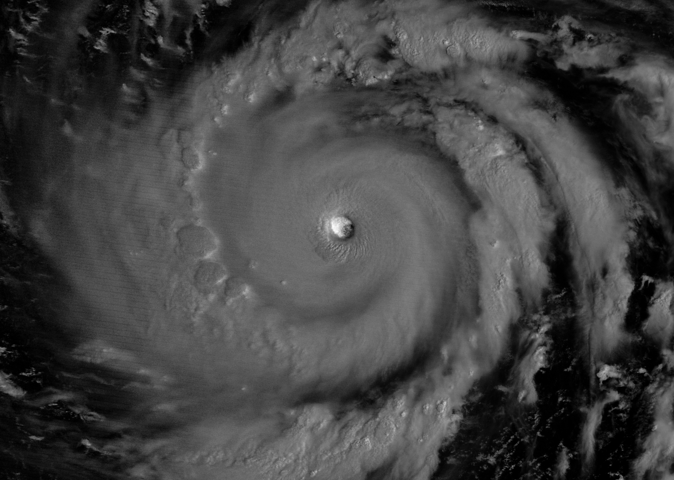
Moonlight illuminates the western side of Super Typhoon Bavi’s eyewall at about 15:30 Universal Time on July 5 (1:30 a.m. local time on July 6). The image was acquired with the VIIRS (Visible Infrared Imaging Radiometer Suite) day-night band on the NOAA-20 satellite.
NASA Earth Observatory/Michala Garrison
In early July 2026, for the second time in three months, a powerful typhoon crossed the U.S. Northern Mariana Islands and Guam in the North Pacific Ocean. Super Typhoon Bavi was at peak intensity when it neared the islands on the night of July 5, bringing winds of 290 kilometers (180 miles) per hour, along with torrential rain and dangerous storm surge.
This nighttime image, captured by the VIIRS (Visible Infrared Imaging Radiometer Suite) on the NOAA-20 satellite, shows Bavi’s eye at about 15:30 Universal Time on July 5 (1:30 a.m. local time on July 6). Light from the Moon, which was in the waning gibbous phase, illuminates the eyewall’s western side. The eye passed over Rota, north of Guam, several hours after the image was acquired.
Bavi became a super typhoon in the early hours of July 4 local time while tracking west over the warm ocean. Satellite observations indicated that sea surface temperatures were around 30 degrees Celsius (86 degrees Fahrenheit) in the region. Bavi was the third tropical cyclone in 2026 to reach category 5 intensity on the Saffir-Simpson wind scale.
The typhoon caused extensive damage across Guam, Rota, and Saipan, according to news reports, downing power poles and lines; flooding roads and littering them with debris; and damaging buildings, including a water distribution station on Rota. U.S. Coast Guard crews worked to clear navigation hazards in the waterways around Guam and the Northern Marianas and reopen ports as dangerous marine conditions subsided, according to reports. This damage comes on top of destructive winds and flooding from Super Typhoon Sinlaku, which crossed the islands in mid-April.
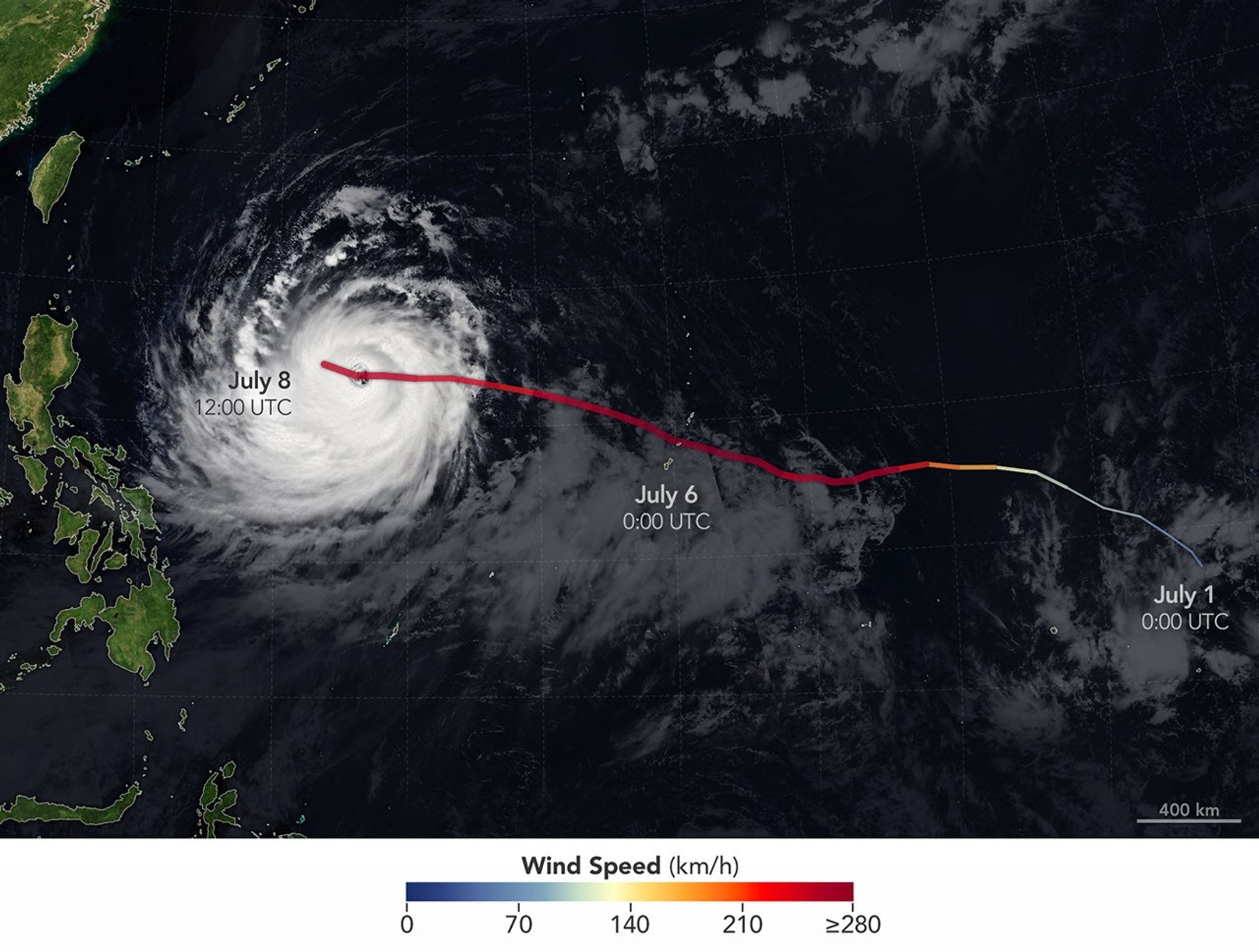
Super Typhoon Bavi tracked west over the Northern Mariana Islands toward Asia in early July 2026. The storm’s clouds and path are overlaid on a Blue Marble: Next Generation image built from scenes captured by the MODIS (Moderate Resolution Imaging Spectroradiometer). The image of the storm was captured by the VIIRS (Visible Infrared Imaging Radiometer Suite) on the NOAA-21 satellite on July 8, 2026, at about 04:30 Universal Time.
NASA Earth Observatory/Michala Garrison
On July 8, Bavi remained a powerful typhoon as it moved west over the Philippine Sea. In the early afternoon, when the image above was captured, the National Weather Service reported maximum sustained wind speeds of 250 kilometers (155 miles) per hour. Forecasts indicated the typhoon’s track could bend northwest toward Taiwan, the Ryukyu Islands of southern Japan, and mainland China and weaken over the next several days.
Writing in Yale Climate Connections, meteorologist Jeff Masters said that Bavi is the type of storm that might be expected when a strong El Niño event is building, which is currently the case. El Niño-year typhoons may form farther east, giving them more time over warm water to intensify before curving toward Asia, Masters explained, “resulting in a greater chance of reaching Category 5 intensity.”
Mountainous landscapes appear green and untouched by fire in a satellite image acquired on June 5, 2026.
NASA Earth Observatory/Michala Garrison
An image of the same area shows a large brown patch spanning much of the image in an image acquired after the fire on June 29, 2026.
NASA Earth Observatory/Michala Garrison
June 5
June 29
A burned landscape spans more than 150 square miles (390 square kilometers) of rugged terrain northwest of Junction, Utah, as seen in this pair of images captured by the OLI (Operational Land Imager) on Landsat 8 and Landsat 9 on June 5, 2026 (left) and June 29, 2026 (right). NASA Earth Observatory images by Michala Garrison.
After a winter of below-average snowpack and an unusually warm and dry start to summer, the National Interagency Fire Center warned that the Great Basin and parts of the Rockies faced an elevated risk of wildfires in July 2026.
The warning proved accurate. By July 7, firefighters labored to contain nearly three dozen large, early-season wildland fires that raced through forests in several parts of the western U.S. Utah was among the most active states, with fires having charred 558 square miles (1,445 square kilometers) and four major fires that were not fully contained still burning.
The Cottonwood fire ranked as one of Utah’s—and the country’s—largest and most destructive fires of the year so far. As of July 7, it had burned 150 square miles (390 square kilometers), just shy of the Babylon fire in eastern Utah. Landsat 9 captured the false-color image (bands 7-5-4) above (right) on June 29, 2026, when blackened vegetation spanned a large patch of rugged terrain along the Beaver River. The image on the left shows the same area on June 5, a few weeks before the fire ignited. In this band combination of shortwave infrared, near infrared, and visible light, unburned vegetation appears bright green, snow is blue, and clouds are white.
Ponderosa pine, oak, sagebrush, and grasses were among the vegetation types that burned. Officials with the state’s forestry division told news media that the Cottonwood fire had destroyed up to 150 structures. Eagle Point Ski Resort, which lost more than 100 condos and 30 cabins, also reported damage to four of its five chairlifts.
The damage to forests was extensive, though isolated patches survived largely unscathed, remaining as green oases within the broader burned area. Among them were the forests around Tushar Campground, the site of a 4-H summer camp. Beaver County officials credited years of forest treatments, such as clearing brush and trimming branches, with helping save the campground and surrounding forests.
The fire spreads especially rapidly on June 23 and June 26. The fire perimeters in this visualization are based on data from NASA’s Fire Events Data Suite.
NASA Earth Observatory/Michala Garrison
As the fire spread, NASA’s Fire Events Data Suite (FEDS) tracked its progression and rate of growth. The visualization above, based on the FEDS system, shows the fire surging on June 23 and tripling in size over 12 hours that day as it spread to the north, east, and south. It also grew rapidly on June 26, when it made a run to the north. FEDS draws on data from the VIIRS (Visible Infrared Imaging Radiometer Suite) sensors aboard the Suomi NPP, NOAA-20, and NOAA-21 satellites, which detect active fires day and night by their thermal infrared signature.
FEDS is one of several tools available to firefighters and emergency management officials when responding to fires. First responders often rely on higher-resolution airborne imagers or on firefighters walking fire edges to map perimeters. FEDS offers a different advantage: consistent, easily accessible data that do not need to be specially requested, according to Tempest McCabe, a University of Maryland scientist based at NASA’s Goddard Space Flight Center who helped develop the tool. As a result, FEDS often detects a fire’s start earlier than other sources and tracks blazes for their full duration. To capitalize on strengths like these, the FEDS team is working closely with operational fire behavior analysts, with support from NASA’s FireSense program, to better understand and anticipate periods of rapid fire spread.
A total of 1,289 firefighters have been deployed to the Cottonwood fire, according to InciWeb, a website managed by the National Interagency Fire Center. As of July 7, the fire was 56 percent contained, but forecasters expect a hot, dry weather pattern to persist in the coming days, with fire behavior likely to be “very active to extreme” over the next 72 hours.
Government satellite data are part of a global system of observations used to track fire behavior and analyze emerging trends. Among the real-time wildfire monitoring tools that NASA makes available are FIRMS (Fire Information for Resource Management System), the Worldview browser, and the Fire Event Explorer.
As of July 7, 2026, fires had burned 5,265 square miles (13,636 square kilometers) across the United States, according to the National Interagency Fire Center. That’s 46 percent more than the 10-year average (2016-2025) for that point in the season.
NASA Earth Observatory images by Michala Garrison, using Landsat data from the U.S. Geological Survey and fire perimeter data from the Fire Events Data Suite. Story by Adam Voiland.
Every month, NASA Earth Observatory features a puzzling satellite image. The July 2026 puzzler appears above.
Your Challenge Identify the location shown in this satellite image. Share what clues you see, where you think it is, and what makes this place interesting or unique to you.
How to Answer Submit your response using this form and select “Puzzler Answer” as the topic. Please include your preferred name or alias.
You can keep it simple and just guess the location. Want to impress us? Tell us which satellite and instrument captured the image, which spectral bands were used, or point out a subtle detail about the geology or history of the area. If something catches your eye, or if this is your home or means something to you, we’d love to hear about it.
The Prize We can’t offer prize money or a trip to space to see Earth like satellites and astronauts do. But we can offer something almost as rewarding: puzzler bragging rights.
About a week after the challenge, we’ll post the answer at the top of this page, along with a link to an Earth Observatory Image of the Day story that explains the image in more detail. We’ll recognize the first person who correctly guesses the location, and we may also highlight readers who share especially thoughtful or interesting answers. By submitting a response, you acknowledge that your comments may be edited, excerpted, and published on this page.
Until then, zoom in, look closely, and enjoy the challenge. See you at the reveal!
In summer 2026, sixteen stadiums across North America hosted matches as part of the FIFA World Cup. Over the years, astronauts aboard the International Space Station have captured a top-down view of the infrastructure, landscapes, and ecosystems surrounding many of these venues.
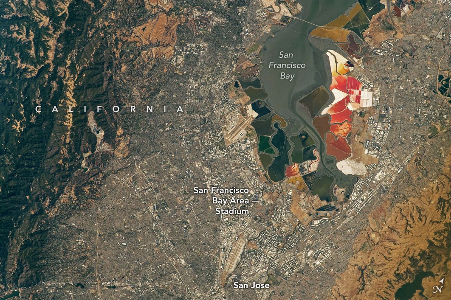
Six of the matches were played at the San Francisco Bay Area Stadium, beginning on June 13 with a match-up between Qatar and Switzerland. This stadium (also called Levi’s Stadium) is located in Santa Clara, California, adjacent to San Jose and around 40 miles (64 kilometers) south of San Francisco. An astronaut aboard the International Space Station took this photo (above) on July 26, 2022.
The stadium, completed in 2014, is surrounded by a mix of recreational, housing, and business infrastructure. The scene includes the southern part of San Francisco Bay, which is 23 years into a 50-year effort to restore up to 90 percent of the region’s salt ponds to tidal wetlands and marshlands, while retaining some of its salt-making heritage.
The Bay Area hosted its sixth and final World Cup match on July 1, when the U.S. faced off against Bosnia and Herzegovina in a knockout match. The U.S. advanced to the round of 16 following a 2-0 win.
April 17, 2022
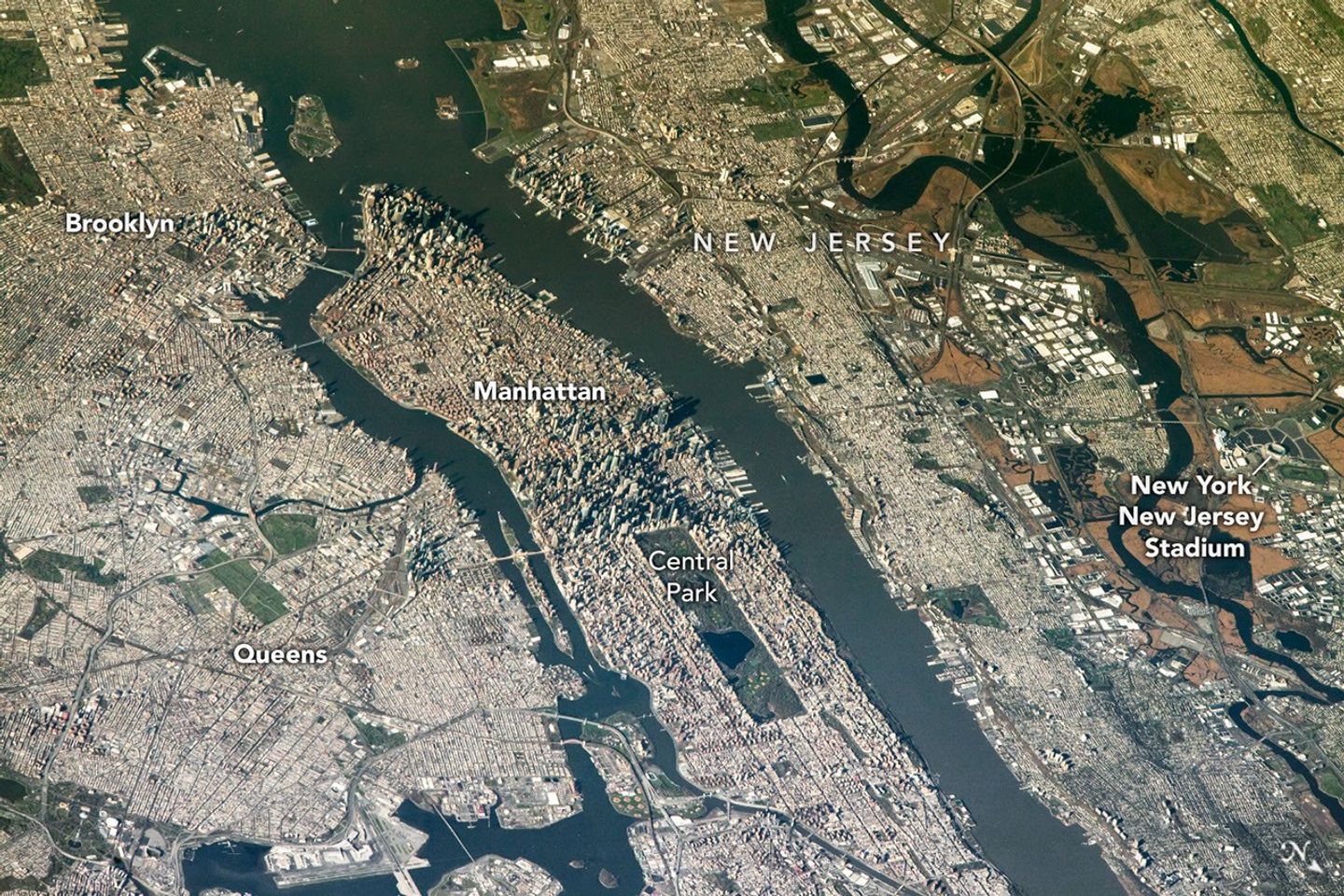
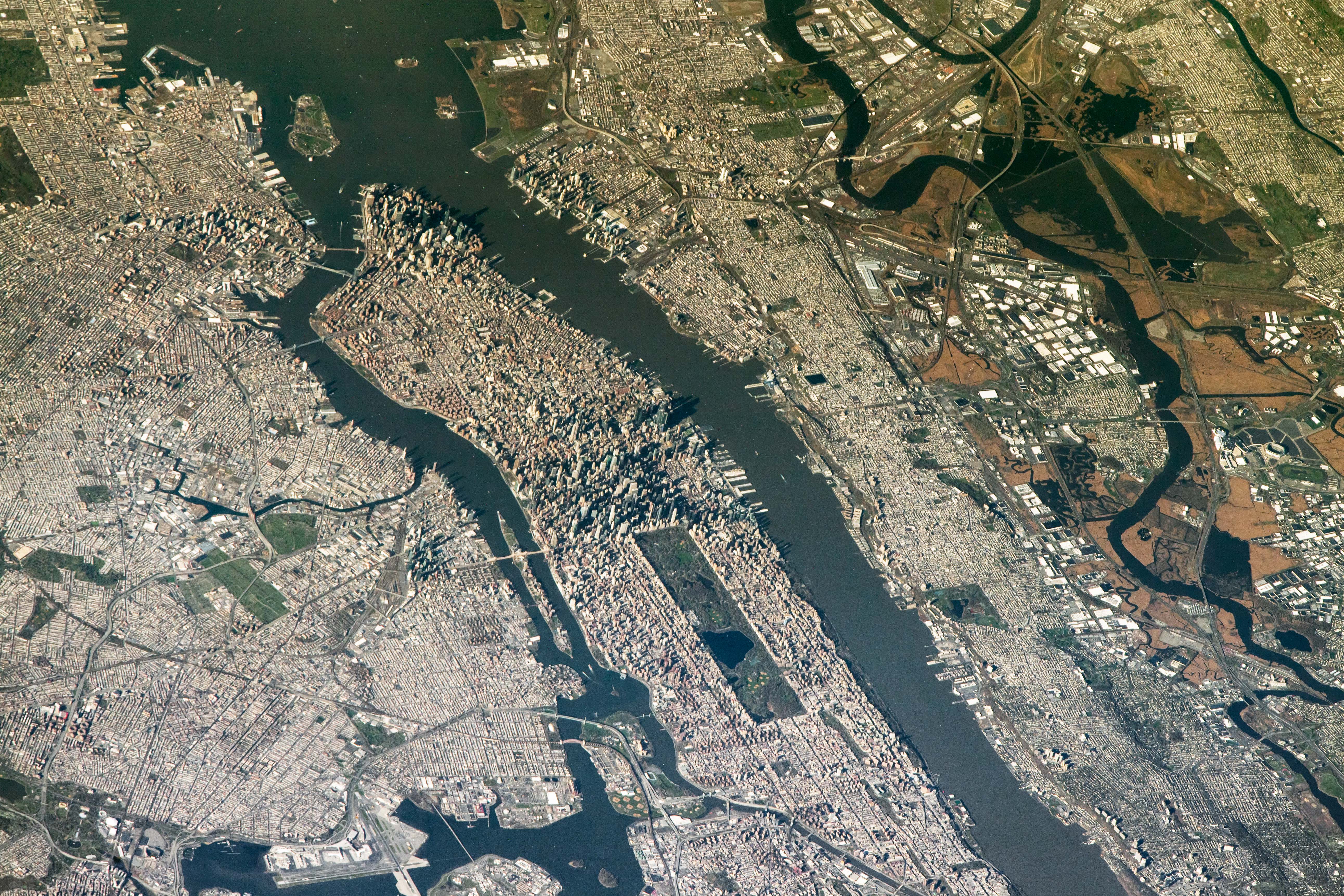
The FIFA World Cup final is scheduled for July 19 at New York New Jersey Stadium, part of the Meadowlands Sports Complex, in East Rutherford, New Jersey. The stadium (also called MetLife Stadium) sits along the New Jersey Turnpike, west of Midtown Manhattan. Note that north is toward the bottom-right of this photo, captured by an astronaut on April 17, 2022.
The area has seen centuries of human impact. Colonists cleared wetlands and cedar forest for settlements, and development for a range of economic and industrial uses followed. In the 20th century, it became an unregulated dumping ground. In recent decades, though, wetland restoration efforts have occurred alongside the development of the sports and entertainment complex.
Other World Cup host cities have also appeared in astronaut photography and satellite imagery. Guadalajara Stadium (Estadio Akron), Los Angeles Stadium (SoFi Stadium), Houston Stadium (NRG Stadium/Reliant Stadium), and BC Place Vancouver (BC Place) are among the venues that have been observed from above.
Astronaut photograph ISS067-E-202213 was acquired on July 26, 2022, with a Nikon D5 digital camera using a focal length of 400 millimeters, and astronaut photograph ISS067-E-18580 was acquired on April 17, 2022, with a Nikon D5 digital camera using a focal length of 1150 millimeters. They are provided by the ISS Crew Earth Observations Facility and the Earth Science and Remote Sensing Unit at NASA Johnson Space Center. The images were taken by a member of the Expedition 67 crew. The images have been cropped and enhanced to improve contrast, and lens artifacts have been removed. The International Space Station Program supports the laboratory as part of the ISS National Lab to help astronauts take pictures of Earth that will be of the greatest value to scientists and the public, and to make those images freely available on the Internet. Additional images taken by astronauts and cosmonauts can be viewed at the NASA/JSC Gateway to Astronaut Photography of Earth. Story by Kathryn Hansen.
In preparing to visit the Moon’s surface, soon-to-be lunar explorers in NASA’s Apollo program first ventured into a variety of unfamiliar landscapes on Earth. A couple of these trips, in the summers of 1965 and 1966, took astronauts to Alaska’s remote Katmai National Park for simulations of field geology in Moon-like environments.
In one exercise, which they called “playing the Moon game,” pairs of astronauts were placed at unfamiliar field sites and asked to pretend as if they were on the Moon. By the account of William Phinney, Apollo’s science training coordinator, they were tasked with collecting representative geologic samples and practicing how to communicate their observations to scientists.
September 29, 2025
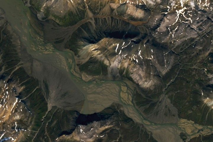
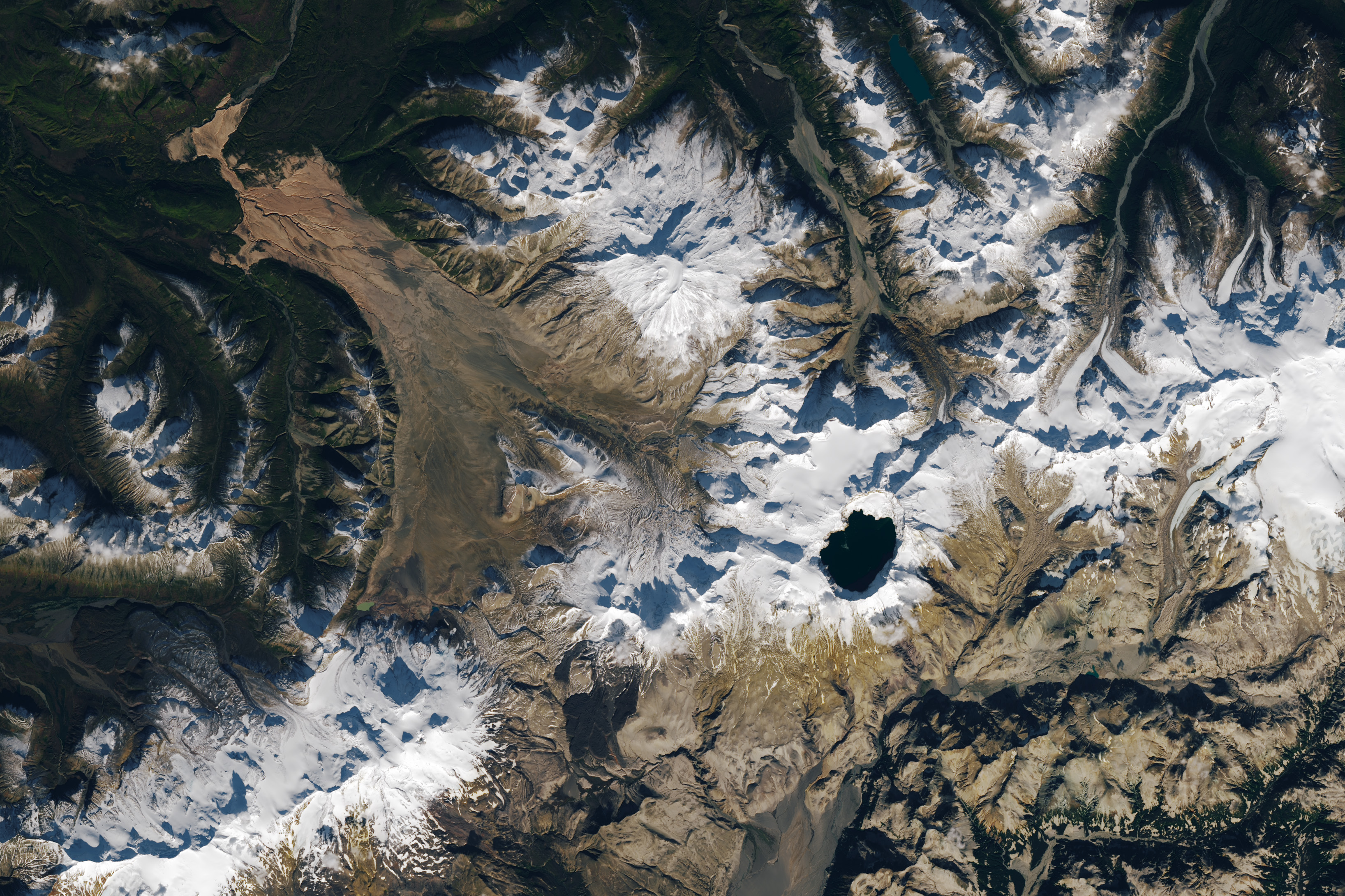
The Alaskan setting for the Moon game was an unusual volcanic landscape called the Valley of Ten Thousand Smokes. The valley is full of debris deposited by the 1912 eruption of Novarupta—the largest volcanic event on Earth in the 20th century.
The images above, acquired on September 29, 2025, with the OLI (Operational Land Imager) on Landsat 9, show the massive ash flow deposited by Novarupta. The layer measures up to 660 feet (200 meters) thick and was emplaced at a searing 1,380 degrees Fahrenheit (750 degrees Celsius).
The Valley of Ten Thousand Smokes, shown in the 1917 photo below, is so named because of the abundance of fumaroles—gas and steam-emitting vents—that filled the valley for a decade after the eruption. A few hundred persisted more than 10 years, with some lasting until the 1990s.
1917
Scientists initially suspected that the monster eruption occurred at Mount Katmai, a neighboring volcano with a large caldera located 6 miles (10 kilometers) east of Novarupta’s dome. However, they later determined that the eruption actually occurred at Novarupta—whose name means “new eruption”—after stealing magma from beneath Katmai. As the magma chamber emptied, Katmai collapsed, forming the 2.5-mile-wide (4-kilometer-wide) caldera present today.
The volcanic landscape in the Valley of Ten Thousand Smokes is far fresher than the ancient lava flows that formed the Moon’s volcanic features. But for the Apollo astronauts, it offered an “excellent opportunity to view volcanic materials and landforms in nearly pristine condition,” Phinney wrote. They studied evidence of fumaroles and examined vertical sections of the deposits where streams had eroded deep gorges.
June 9, 1991
Researchers continue to visit this Alaskan wilderness in search of clues that could help decipher the geology of the Moon and Mars. In 2024, the Goddard Instrument Field Team (GIFT) trekked to the Valley of Ten Thousand Smokes to study its icy volcanic landscape. Like the valley, Mars contains glaciers and ice sheets layered with dust and ash, a dynamic and difficult-to-interpret environment.
Advancing lunar science, the GIFT team also collected samples from rock formations comparable to the Moon’s Gruithuisen Domes. These mysterious features are made of hardened lava with a different composition than the surrounding rock. With more to learn about our nearest celestial neighbor, the spirit of the Moon game lives on in the 21st century.
NASA Earth Observatory images by Lauren Dauphin, using Landsat data from the U.S. Geological Survey. Photos from National Geographic Society Katmai expeditions photographs, Archives and Special Collections, Consortium Library, University of Alaska Anchorage, and from the U.S. Geological Survey Volcano Hazards Program. Story by Lindsey Doermann.
From Civil War battlegrounds to industrial landmarks to the country’s earliest national parks, these places helped shape the United States we know today.
Samuel Pierpont Langley conducted the first successful flight of an unpiloted, engine-driven, heavier-than-air craft from a houseboat near Chopawamsic Island…
Tropical Storm Arthur’s white storm clouds cover the waters off the U.S. Gulf Coast. Some clouds extend inland over parts of Texas and Louisiana.
NASA Earth Observatory/Michala Garrison
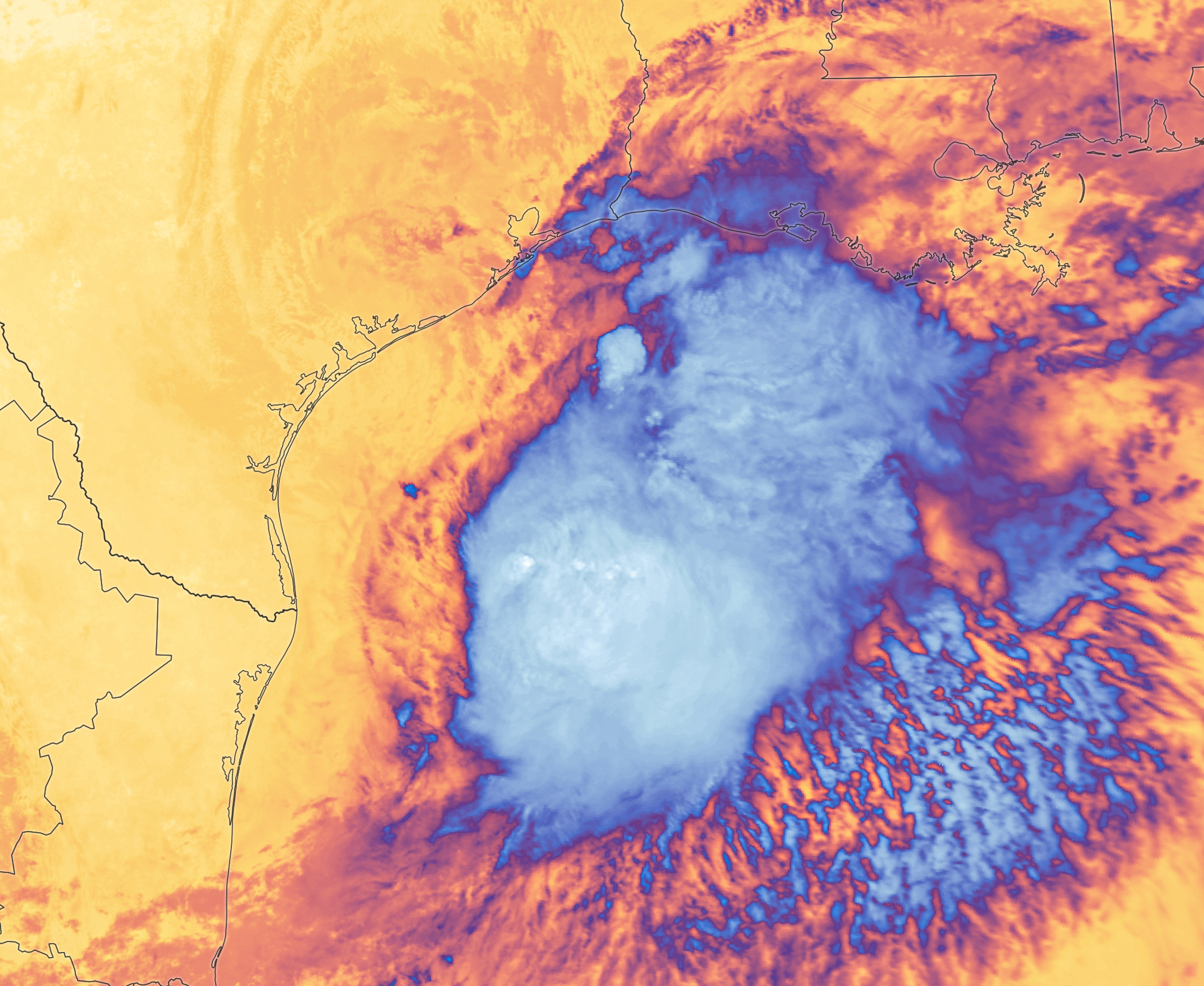
White and purple areas of cloud off the Gulf Coast indicate the cooler areas of cloud tops associated with Tropical Storm Arthur.
NASA Earth Observatory/Michala Garrison
Natural color
brightness temperature
Images from the MODIS (Moderate Resolution Imaging Spectroradiometer) on NASA’s Terra satellite show Tropical Storm Arthur on the morning of June 17, 2026. The left image is natural color; the right shows infrared signals known as brightness temperature. NASA Earth Observatory images by Michala Garrison.
Tropical Storm Arthur, the first named storm of the 2026 Atlantic hurricane season, brought high winds and heavy rain to the U.S. Gulf Coast in mid-June.
NASA’s Terra satellite captured this natural-color image (left) at 10:30 a.m. Central Time (15:30 Universal Time) on June 17. The second image (right) depicts infrared signals known as brightness temperature, which help distinguish cooler cloud tops (white and purple) from the warmer surface below (yellow and orange). Around the time these images were acquired, the system had just recently been designated a tropical storm, according to the National Hurricane Center (NHC).
Though Arthur stayed below hurricane strength, it still delivered strong winds to parts of the Gulf Coast as it tracked northeast. The storm had maximum sustained winds of 40 miles (65 kilometers) per hour around the time these images were captured. Tropical-storm-force winds extended 175 miles (280 kilometers) from the storm’s center, the NHC reported. Measurements at Galveston, Texas, for instance, showed a gust of 48 miles per hour.
The storm also produced heavy rainfall that the National Weather Service warned could lead to life-threatening flash flooding. Estimates from IMERG (the Integrated Multi-Satellite Retrievals for GPM), a product of the GPM (Global Precipitation Measurement) mission, showed high rainfall rates over Gulf waters and extending inland on June 17.
As Arthur weakened and became less organized, it continued to bring abundant moisture to central Gulf Coast states on June 18. The National Weather Service reported rainfall rates of 3 inches (7.6 centimeters) per hour in southeastern Louisiana. Forecasts indicated that storm-total rainfall amounts could exceed 12 inches (30 centimeters) in areas, with some locations seeing totals approaching 20 inches (51 centimeters).
NASA Earth Observatory images by Michala Garrison, using MODIS data from NASA EOSDIS LANCE and GIBS/Worldview. Story by Kathryn Hansen.
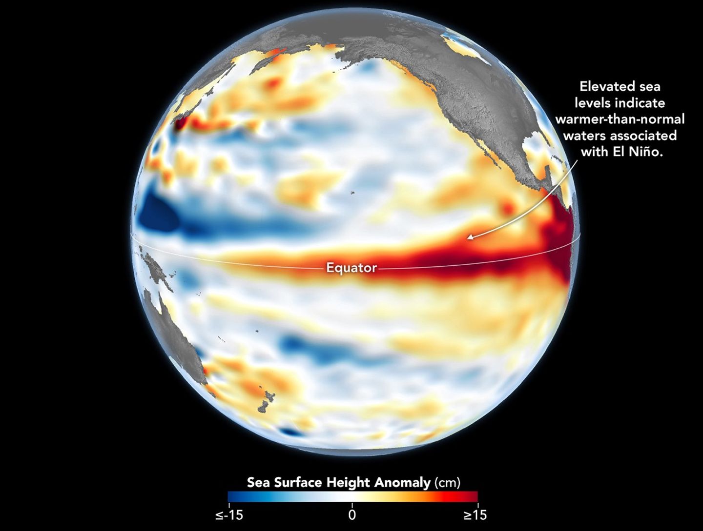
Higher-than-normal sea surfaces (red) are visible in the central and eastern Pacific on June 8, 2026, a few days before El Niño was declared. Data for the map were acquired by the Sentinel-6 Michael Freilich satellite and processed by scientists at NASA’s Jet Propulsion Laboratory (JPL).
NASA Earth Observatory/Lauren Dauphin
El Niño, characterized by warmer-than-normal water temperatures in parts of the equatorial Pacific, made its return in June 2026. Observations of sea surface height from the Sentinel-6 Michael Freilich satellite that month indicated that the 2026 event was continuing to strengthen.
The natural, recurring phenomenon can have widespread effects, typically bringing wetter conditions to the U.S. Southwest and drought to countries in the western Pacific, such as Indonesia and Australia. NOAA declared an El Niño on June 11, after sea surface temperatures in the central and eastern equatorial Pacific measured at least 0.5 degrees Celsius above average for several consecutive months.
Meanwhile, NASA scientists have been observing a complementary sign of El Niño: areas of elevated sea surface height. When ocean water warms, it expands in volume and causes the sea surface to rise—making the water’s height a reliable indicator of ocean temperatures. Warmer-than-normal temperatures, hence higher sea surface heights, in parts of the equatorial Pacific Ocean are associated with El Niño.
The map above depicts sea surface height anomalies across the central and eastern Pacific Ocean as observed on June 8, 2026. Shades of red indicate sea levels that were higher than average. Normal sea level conditions appear white, and lower areas are blue.
Data for the map were acquired by the Sentinel-6 Michael Freilich satellite—launched in 2020 by NASA and led by ESA (European Space Agency)—and processed by scientists at NASA’s Jet Propulsion Laboratory (JPL). Note that signals related to seasonal cycles and long-term trends have been removed to highlight sea level anomalies associated with El Niño and other short-term natural phenomena.
Earlier in spring 2026, the satellite started to detect precursor signs of El Niño as swells of warm water hundreds of miles wide, known as Kelvin waves, moved from the western Pacific to the eastern Pacific. That happens when trade winds in the western equatorial Pacific weaken and then temporarily reverse to blow from the west. Warm water piles up in the east, deepening the warm surface layer, lowering the thermocline, and suppressing the upwelling that usually keeps waters along the Pacific coasts of the Americas cooler.
This buildup of heat beneath the water’s surface is what sea surface height observations capture. It goes beyond surface temperature measurements to indicate how much heat is stored in the subsurface. That’s important because a shallow warm layer might not have much impact on climate and weather, while a large reservoir of heat below the surface can matter more.
According to JPL sea level researcher Severine Fournier, deputy project scientist for Sentinel-6 Michael Freilich, conditions in the western Pacific on June 8 looked similar to those from the same time in 1997, a year when an exceptionally strong El Niño emerged. Warm conditions in the eastern Pacific in 2026 have lagged behind, however, with fewer Kelvin waves built up by the same date.
Still, more warm Kelvin waves appeared to be approaching the eastern Pacific, meaning El Niño was still strengthening. Whether it catches up to 1997 depends on ocean activity in the coming weeks. “For now, it looks like it’s going to be a big one—more so than I would have said last week—but we still need more observations to know what’s going to happen.”
NASA Earth Observatory image by Lauren Dauphin, using modified Copernicus Sentinel data (2023) processed by the European Space Agency and further processed by Josh Willis, Severin Fournier, and Kevin Marlis/NASA/JPL-Caltech. Story by Kathryn Hansen.
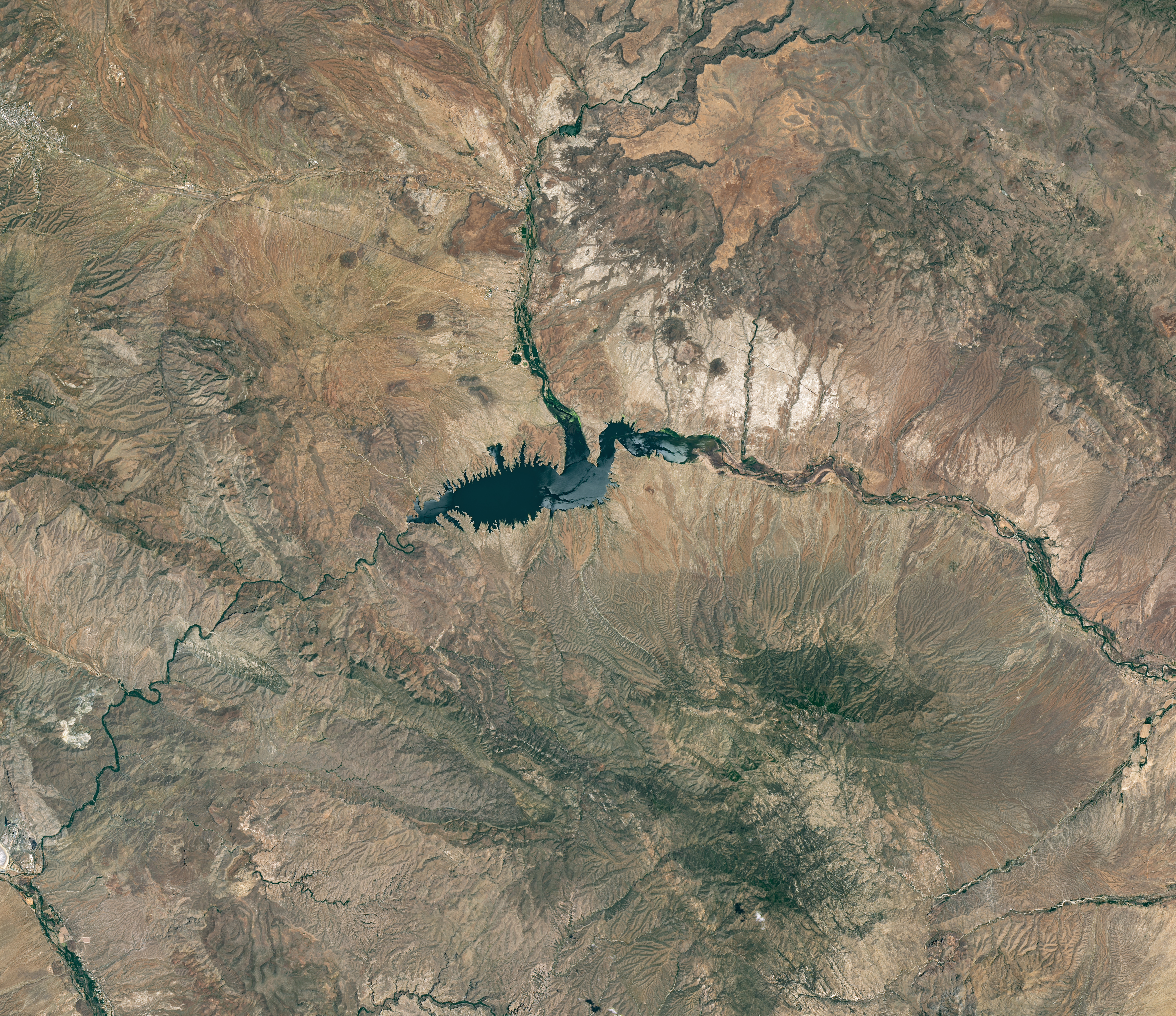
The reservoir appears lake-like and expansive in an image acquired in June 2023.
NASA Earth Observatory/Michala Garrison
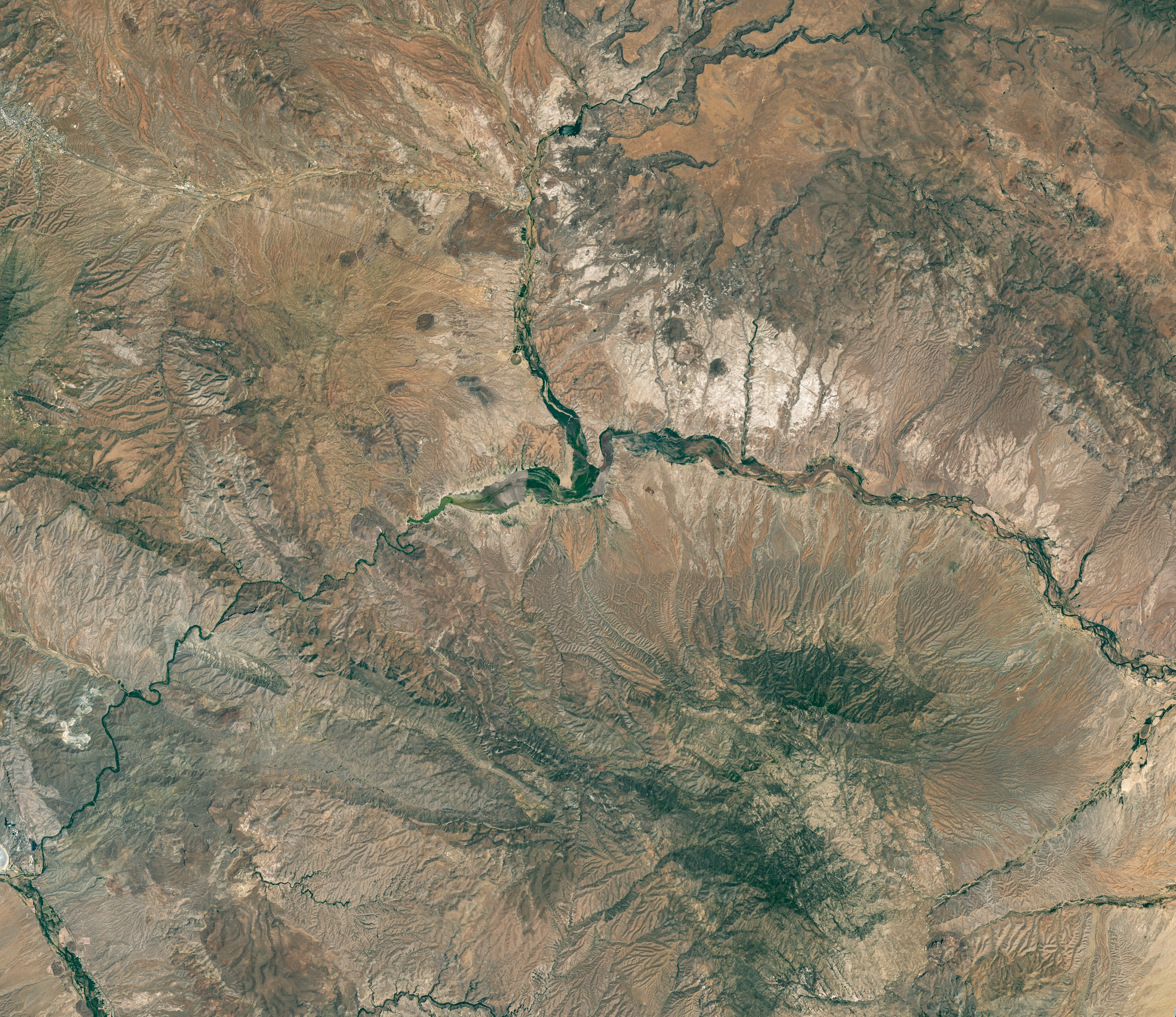
The reservoir is nearly empty by May 2026. The Gila River’s natural channel is now visible and flanked with green vegetation in what had been the bottom of the reservoir.
NASA Earth Observatory/Michala Garrison
June 7, 2023
May 22, 2026
Little water remains in the San Carlos Reservoir in May 2026 (right) compared to fuller conditions in June 2023 (left). Images were captured by the OLI (Operational Land Imager) on the Landsat 9 and 8 satellites, respectively. NASA Earth Observatory images by Michala Garrison.
The Gila River is among the Southwest’s most important rivers, delivering water for people, farms, and wildlife while linking the snow-fed mountains of southwestern New Mexico to the desert lowlands of southwestern Arizona.
In wetter years, seasonal snowfall on the Mogollon Mountains and Black Range provides much of the river’s spring flow and helps refill San Carlos Reservoir, which is formed by the Coolidge Dam. When filled to capacity, the reservoir is one of Arizona’s largest bodies of water.
However, in 2026, lackluster snowfall left the mountain snowpack in the Gila River watershed at 2 percent of the 1991-2020 March median. The limited snowpack pushed April streamflow to 39 percent of normal. By June, after mandatory water releases for downstream agriculture, the reservoir held less than 400 acre-feet of water.
The Landsat image above (right) shows the near-empty reservoir on May 22, 2026, when it stored 389 acre-feet of water—less than 1 percent full; the other image (left) shows the same area in June 2023, when it was about 60 percent full. The green vegetation growing along the river channel and reservoir edge includes a mixture of tamarisk, willow, cottonwood, sedges, and grasses.
Officials closed the reservoir indefinitely on June 5, 2026, after the declining water levels contributed to low oxygen levels—hypoxia—that killed virtually all of its fish. Species living in the reservoir included largemouth bass, black crappie, bluegill, channel catfish, flathead catfish, and several stocked species, including brown trout and rainbow trout. The decomposing fish may pose health risks to people attempting to boat or fish, the San Carlos Recreation and Wildlife Department warned.
The reservoir has hit similarly low water levels in the past, running out of water at least 20 times since it was filled in 1930, according to news reports. Even when the dam and reservoir were first dedicated, there was enough grass growing on the dried reservoir bottom that humorist Will Rogers famously quipped to President Calvin Coolidge: “If that was my lake, I’d mow it.”
Other years with major fish kills include 1976 and 2018. After more than 5 million fish died during a similar event in 1976, the Gila Heraldreported that it took five years for the lake’s ecosystem to rebound.
The region is currently in the midst of a multi-year dry period that has left much of the Gila River’s headwaters in New Mexico in a state of severe drought, according to data from the U.S. Drought Monitor.
However, the river’s flow is highly variable, and heavy rains during the coming wet season could help the reservoir recover. A seasonal monsoon outlook released by NOAA in May 2026 projected a 33 to 50 percent chance that an above-average amount of rain would fall in the region that summer. El Niño in the central and eastern equatorial Pacific, which was strengthening in late spring 2026, can make heavy rains in the U.S. Southwest more likely.
NASA Earth Observatory images by Michala Garrison, using Landsat data from the U.S. Geological Survey.Story by Adam Voiland.
The reservoir appears lake-like and expansive in an image acquired in June 2023.
NASA Earth Observatory/Michala Garrison
The reservoir is nearly empty by May 2026. The Gila River’s natural channel is now visible and flanked with green vegetation in what had been the bottom of the reservoir.
NASA Earth Observatory/Michala Garrison
June 7, 2023
May 22, 2026
Little water remains in the San Carlos Reservoir in May 2026 (right) compared to fuller conditions in June 2023 (left). Images were captured by the OLI (Operational Land Imager) on the Landsat 9 and 8 satellites, respectively. NASA Earth Observatory images by Michala Garrison.
The Gila River is among the Southwest’s most important rivers, delivering water for people, farms, and wildlife while linking the snow-fed mountains of southwestern New Mexico to the desert lowlands of southwestern Arizona.
In wetter years, seasonal snowfall on the Mogollon Mountains and Black Range provides much of the river’s spring flow and helps refill San Carlos Reservoir, which is formed by the Coolidge Dam. When filled to capacity, the reservoir is one of Arizona’s largest bodies of water.
However, in 2026, lackluster snowfall left the mountain snowpack in the Gila River watershed at 2 percent of the 1991-2020 March median. The limited snowpack pushed April streamflow to 39 percent of normal. By June, after mandatory water releases for downstream agriculture, the reservoir held less than 400 acre-feet of water.
The Landsat image above (right) shows the near-empty reservoir on May 22, 2026, when it stored 389 acre-feet of water—less than 1 percent full; the other image (left) shows the same area in June 2023, when it was about 60 percent full. The green vegetation growing along the river channel and reservoir edge includes a mixture of tamarisk, willow, cottonwood, sedges, and grasses.
Officials closed the reservoir indefinitely on June 5, 2026, after the declining water levels contributed to low oxygen levels—hypoxia—that killed virtually all of its fish. Species living in the reservoir included largemouth bass, black crappie, bluegill, channel catfish, flathead catfish, and several stocked species, including brown trout and rainbow trout. The decomposing fish may pose health risks to people attempting to boat or fish, the San Carlos Recreation and Wildlife Department warned.
The reservoir has hit similarly low water levels in the past, running out of water at least 20 times since it was filled in 1930, according to news reports. Even when the dam and reservoir were first dedicated, there was enough grass growing on the dried reservoir bottom that humorist Will Rogers famously quipped to President Calvin Coolidge: “If that was my lake, I’d mow it.”
Other years with major fish kills include 1976 and 2018. After more than 5 million fish died during a similar event in 1976, the Gila Heraldreported that it took five years for the lake’s ecosystem to rebound.
The region is currently in the midst of a multi-year dry period that has left much of the Gila River’s headwaters in New Mexico in a state of severe drought, according to data from the U.S. Drought Monitor.
However, the river’s flow is highly variable, and heavy rains during the coming wet season could help the reservoir recover. A seasonal monsoon outlook released by NOAA in May 2026 projected a 33 to 50 percent chance that an above-average amount of rain would fall in the region that summer. El Niño in the central and eastern equatorial Pacific, which was strengthening in late spring 2026, can make heavy rains in the U.S. Southwest more likely.
NASA Earth Observatory images by Michala Garrison, using Landsat data from the U.S. Geological Survey.Story by Adam Voiland.
The Nebraska Sandhills stretch across the north-central part of the state in this image acquired on August 19, 2025, with the OLI (Operational Land Imager) on Landsat 8.
NASA Earth Observatory/Lauren Dauphin
Editor’s Note: Today’s story is the answer to the June Puzzler.
The undulating landscape of north-central Nebraska may be easy to overlook among the iconic dune fields of the world. Far from any coast or desert, the Nebraska Sandhills—comprising the Western Hemisphere’s largest system of sand dunes—bring their own brand of beauty and value. Grasslands blanket the rolling hills, providing grazing grounds for livestock, while lakes and wetlands dot the landscape, supporting diverse plant and animal life.
Much of the sand forming the hills originated in the Rocky Mountains. Rivers carried the eroded material down from the mountains and deposited it across the Great Plains during the Pleistocene. In times of drought, winds blowing predominantly from the north or south lofted sand out of dried riverbeds, gradually building and shaping dunes. About 3,500 years ago, grassland vegetation stabilized the features. Today, the rippled pattern spans about 20,000 square miles (52,000 square kilometers), about one-quarter of the state of Nebraska.
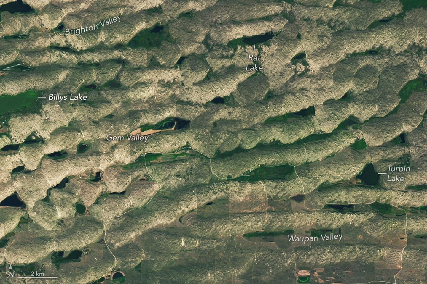
Some of the largest, grassland-covered dunes in the Nebraska Sandhills are found in the northwestern part of the region, shown in this image acquired on August 19, 2025, with the OLI (Operational Land Imager) on Landsat 8.
NASA Earth Observatory/Lauren Dauphin
Some of the largest dunes occur in and around the area shown in the detailed image above, near the northern edge of the Sandhills region. These transverse dunes stand as high as 400 feet (120 meters) and extend for several miles. Their northern slopes are gentler than their southern slopes, reflecting the dominant influence of northerly winds. In other areas, dunes are more symmetric, suggesting that winds blew with nearly equal strength from the north and south, alternating with the seasons.
The grasslands that now cover the hills constitute pastureland for grazing livestock. Ranching expanded significantly in the area after passage of the Kinkaid Act in 1904, which allotted 640-acre parcels of land to ranchers who would settle it. Today, far more cattle than humans occupy the region, and half of Nebraska’s nearly 23 million acres of rangeland and pastureland are in the Sandhills. Some ranchers graze their cattle in patterns meant to approximate the large bison herds that once roamed the land.
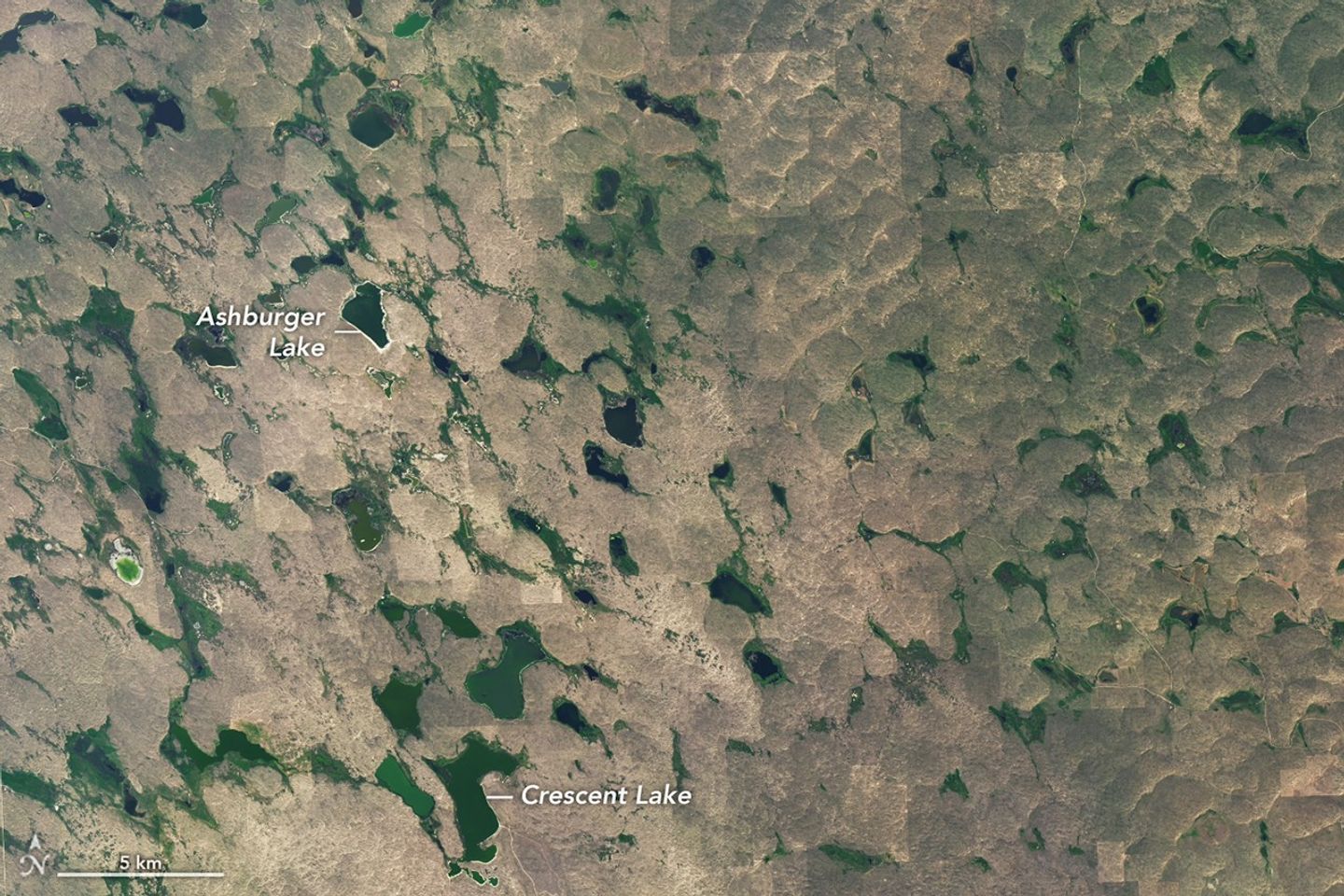
Lakes and wetlands fill the valleys between dunes in Crescent Lake National Wildlife Refuge, shown in this image acquired on August 19, 2025, with the OLI (Operational Land Imager) on Landsat 8.
NASA Earth Observatory/Lauren Dauphin
Though much of the land in the Sandhills is privately owned, some is set aside in protected public lands. One of these areas, Crescent Lake National Wildlife Refuge on the southwestern edge of the Sandhills region, is shown above. Wetlands, including shallow lakes, marshes, and wet meadows, fill some of the valleys between the dunes. The land here is sponge-like, with precipitation seeping down through the soil and recharging groundwater instead of flowing off through stream channels.
Located along the Central Flyway, the refuge is a haven for migratory birds, and dozens of species of waterfowl, marsh birds, and shorebirds utilize the area. Among other wildlife, several types of turtles thrive in the ponds and prairies. Wetlands across the Sandhills support rare species such as the whooping crane, western prairie fringed orchid, and Topeka shiner.
NASA Earth Observatory images by Lauren Dauphin, using Landsat data from the U.S. Geological Survey. Story by Lindsey Doermann.
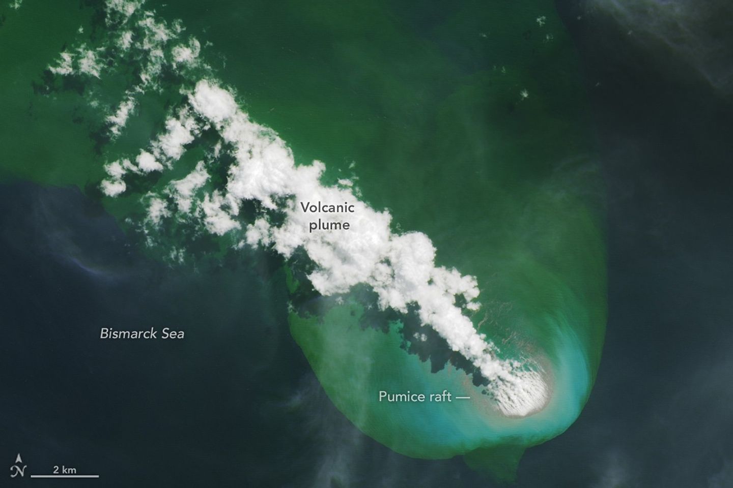
On May 8, 2026, satellites detected signs of an unexpected submarine volcanic eruption in the Bismarck Sea near the islands of Papua New Guinea. Over the next several weeks, plumes of steam and ash streamed over the sea, and areas of discolored water surrounded the eruption site. Relatively little is known about the ocean floor in this area or the volcanic feature that is presently erupting. But experts think the new activity, ongoing as of mid-June, might be occurring along the Titan Ridge and has the potential to form an ephemeral new island.
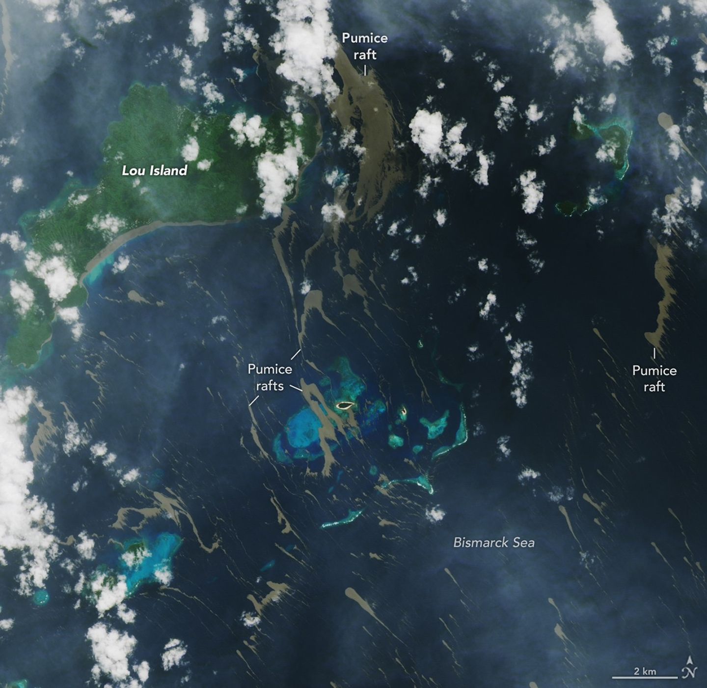
Despite the unknowns, the effects of the eruption became unmistakable for some communities in Papua New Guinea’s Admiralty Islands. In early June, rafts of pumice drifted northwest from the eruption site and clogged up coastlines on several of the islands. Bands of the buoyant volcanic material are visible in this image, acquired with the OLI (Operational Land Imager) on Landsat 8 on June 4, as they drifted with surface currents on the Bismarck Sea.
Several days after the image, news outlets reported acute impacts from thick masses of pumice reaching coastal areas. Communities on Lou Island and Baluan Island, to the south, were described by officials as among the worst affected, according to reports from local media. Outlets reported that a layer of pumice up to several meters thick blanketed the shore, cutting off access to the water. The volcanic fragments similarly choked the coast and key waterways around the much larger Manus Island, about 125 kilometers (80 miles) northwest of the volcano and out of frame.
A submarine volcano produces a plume of discolored water and vents steam into the air in an image acquired on June 4, 2026, with the OLI (Operational Land Imager) on Landsat 8. Pumice is visible near the base of the plume and exhibits a thermal signature in infrared imagery.
NASA Earth Observatory/Lauren Dauphin
Studies of past pumice raft events have found that the material can remain afloat for months to years before sinking out of satellite view. Larger rafts can form with the help of ash, which serves to “weld” together fragments of the porous rock, said Jim Garvin, the chief scientist at NASA’s Goddard Space Flight Center, noting this process occurred during the 2022 eruption of Hunga Tonga-Hunga Ha‘apai. “These masses can pile up around erupting vents to protect the eruption centers and produce ephemeral new lands in some cases,” he said. When adrift, such pumice platforms can act as floating homes for marine organisms—from microalgae to bryozoans to barnacles—and enable them to disperse over long distances.
Though beneficial to life in some ways, the rafts can pose serious threats to humans and other species. Some of the larger fragments of pumice stack up to form ridges when they reach the coastlines of islands. Reports from Papua New Guinea highlight the disruptions to fishing, the transport of goods, and access to critical services that can occur when pumice accumulates along the coast.
Communities have expressed concerns over the pumice’s effects on marine ecosystems, as well. Researchers have noted that the sustained presence of pumice can block sunlight and may inhibit photosynthesis in seagrass and corals below, and the rocks may physically damage reef structures. In a review of the ecological effects of pumice reaching Japan’s coast in 2021, researchers noted the die-off of filter-feeding fish in fishery cages from ingesting pumice, warning that other wildlife may be harmed by mistakenly consuming the rocks.
New studies using an ensemble of orbital remote sensing platforms—including Landsat, hyperspectral instruments, and imaging radars—are tracking developments in this Bismarck Sea region, Garvin said. These observations can provide new perspectives on hazards as well as unique scientific opportunities for improved understanding of submarine eruptions.
NASA Earth Observatory images by Lauren Dauphin, using Landsat data from the U.S. Geological Survey. Story by Lindsey Doermann.
A pair of Landsat images shows 40 years of westward urban expansion from Guadalajara, Mexico. The Thematic Mapper on Landsat 5 captured the left image in 1986; the Operational Land Imager on Landsat 8 captured the right image in 2026.
A pair of Landsat images shows 40 years of westward urban expansion from Guadalajara, Mexico. The Thematic Mapper on Landsat 5 captured the left image in 1986; the Operational Land Imager on Landsat 8 captured the right image in 2026.
NASA Earth Observatory / Lauren Dauphin
A pair of Landsat images shows 40 years of westward urban expansion from Guadalajara, Mexico. The Thematic Mapper on Landsat 5 captured the left image in 1986; the Operational Land Imager on Landsat 8 captured the right image in 2026.
A pair of Landsat images shows 40 years of westward urban expansion from Guadalajara, Mexico. The Thematic Mapper on Landsat 5 captured the left image in 1986; the Operational Land Imager on Landsat 8 captured the right image in 2026.
NASA Earth Observatory / Lauren Dauphin
April 13, 1986
April 27, 2026
April 13, 1986 – April 27, 2026
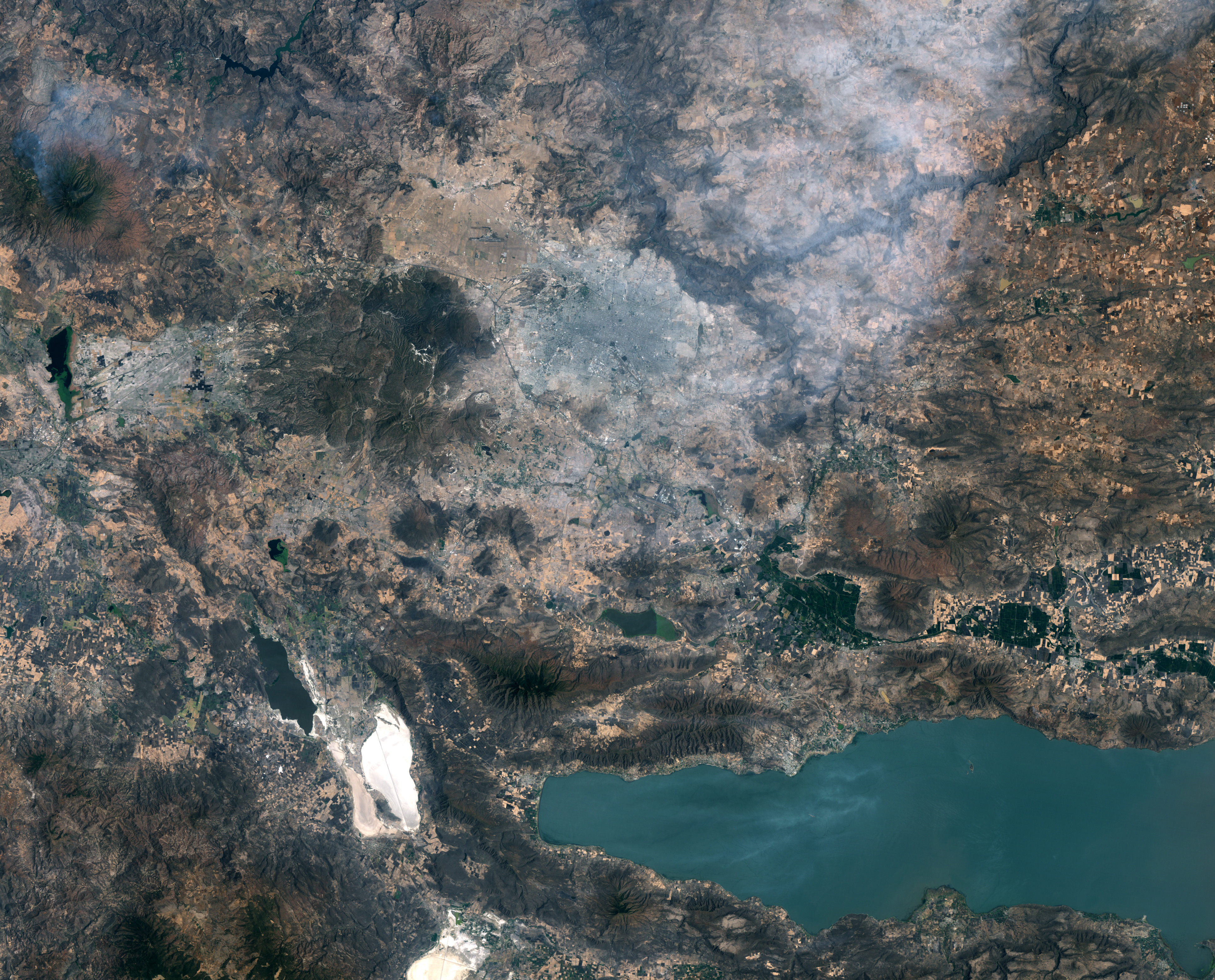
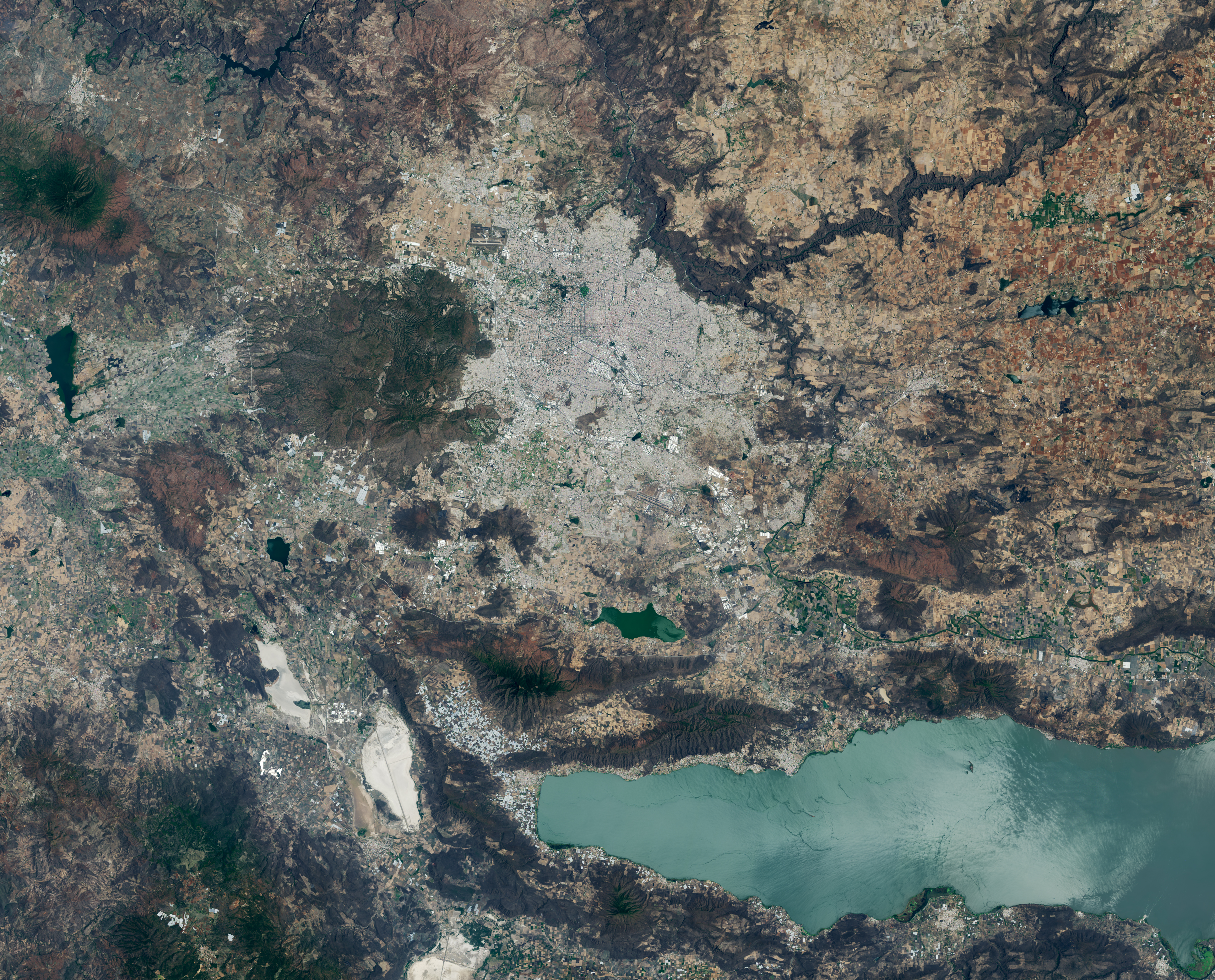
A pair of Landsat images shows 40 years of westward urban expansion from Guadalajara, Mexico. The TM (Thematic Mapper) on Landsat 5 captured the left image in 1986; the OLI (Operational Land Imager) on Landsat 8 captured the right image in 2026.
Guadalajara, Mexico, was quite a different place when it last hosted World Cup games 40 years ago. The city welcomed matches in June 1986 and did so again in 2026, when South Korea faced Czechia at Guadalajara Stadium in the opening round of the 2026 FIFA World Cup.
In 1986, Guadalajara Stadium had not yet been built in Zapopan, the fast-growing municipality just northwest of Guadalajara. Many of that year’s World Cup matches were held instead at Jalisco Stadium in northeastern Guadalajara. It was in that stadium that France defeated Brazil in a penalty shootout in the 1986 quarterfinals, in what is widely regarded as one of the most memorable World Cup games of all time.
As seen in the Landsat images above, the land where Guadalajara Stadium (also called Estadio Akron) now sits was farmland in 1986. The new stadium, built in 2010 to host Mexico’s Club Deportivo Guadalajara, or Chivas, lies near the Sierra la Primavera volcanic complex, a rugged landscape full of lava flows, volcanic domes, steam vents, and hot springs. The architects who designed the stadium took inspiration from the nearby volcanic terrain, creating a structure that rises from a grassy earthen berm meant to resemble the flanks of a volcano, topped with a white roof reminiscent of a volcanic cloud.
About 95,000 years ago, the volcanic system underneath Sierra la Primavera produced a massive eruption that caused a caldera 11 kilometers (7 miles) in diameter to slump downward. Water filled the depression for tens of thousands of years, but tectonic uplift and the accumulation of sediment eventually led to the demise of the lake. Erosion wore away the softer surrounding rock over time, leaving harder, erosion-resistant volcanic rocks within the circular feature that now stand high above the surrounding terrain.
Starting about 60,000 years ago, several lava domes erupted along the southern edge of the caldera. The youngest of them, Cerro del Colli, formed about 30,000 years ago, leaving the dome-shaped feature just south of the stadium and contributing to a broader landscape dotted with other volcanic domes and cinder cones.
Today, much of the original caldera has been preserved as a forested area known as La Primavera Biosphere Reserve, even as development has partially encircled it during the past 40 years. The population of the Guadalajara metro area has grown from about 2.7 million in 1986 to more than 5.5 million now, with particularly rapid growth in Zapopan, a burgeoning tech hub sometimes billed as “Mexico’s Silicon Valley.” A prominent development visible in Landsat images is Guadalajara Technology Park, one of several new industrial parks in Zapopan. New greenhouses have also come to the area en masse, including south of the reserve, where they are mostly used to grow fruits and vegetables.
World Cup fever runs particularly high in Guadalajara, which is hosting World Cup matches for the third time. During Brazil’s legendary title run in 1970, when Pelé led the team, Jalisco Stadium was the venue for Brazil’s first-round, quarterfinal, and semifinal matches. To commemorate him, the city in May 2026 erected a 9.5-meter (31-foot) bronze statue of the iconic football (soccer) player.
Even the animals at Guadalajara Zoo are taking part in the festivities, with elephants, gorillas, giraffes, capybaras, pumas, and macaws “predicting” match winners by choosing between food, shirts, boxes, soccer balls, and other items. A puma named Muluk predicted South Korea would beat Czechia by sniffing and moving a ball, one newspaper reported.
Guadalajara will host four first-round matches: South Korea vs. Czechia on June 12, Mexico vs. South Korea on June 18, Colombia vs. Democratic Republic of the Congo on June 23, and Uruguay vs. Spain on June 26.
NASA Earth Observatory images by Lauren Dauphin, using Landsat data from the U.S. Geological Survey. Story by Adam Voiland.
A pair of Landsat images shows 40 years of westward urban expansion from Guadalajara, Mexico. The Thematic Mapper on Landsat 5 captured the left image in 1986; the Operational Land Imager on Landsat 8 captured the right image in 2026.
A pair of Landsat images shows 40 years of westward urban expansion from Guadalajara, Mexico. The Thematic Mapper on Landsat 5 captured the left image in 1986; the Operational Land Imager on Landsat 8 captured the right image in 2026.
NASA Earth Observatory / Lauren Dauphin
A pair of Landsat images shows 40 years of westward urban expansion from Guadalajara, Mexico. The Thematic Mapper on Landsat 5 captured the left image in 1986; the Operational Land Imager on Landsat 8 captured the right image in 2026.
A pair of Landsat images shows 40 years of westward urban expansion from Guadalajara, Mexico. The Thematic Mapper on Landsat 5 captured the left image in 1986; the Operational Land Imager on Landsat 8 captured the right image in 2026.
NASA Earth Observatory / Lauren Dauphin
April 13, 1986
April 27, 2026
April 13, 1986 – April 27, 2026
A pair of Landsat images shows 40 years of westward urban expansion from Guadalajara, Mexico. The TM (Thematic Mapper) on Landsat 5 captured the left image in 1986; the OLI (Operational Land Imager) on Landsat 8 captured the right image in 2026.
Guadalajara, Mexico, was quite a different place when it last hosted World Cup games 40 years ago. The city welcomed matches in June 1986 and did so again in 2026, when South Korea faced Czechia at Guadalajara Stadium in the opening round of the 2026 FIFA World Cup.
In 1986, Guadalajara Stadium had not yet been built in Zapopan, the fast-growing municipality just northwest of Guadalajara. Many of that year’s World Cup matches were held instead at Jalisco Stadium in northeastern Guadalajara. It was in that stadium that France defeated Brazil in a penalty shootout in the 1986 quarterfinals, in what is widely regarded as one of the most memorable World Cup games of all time.
As seen in the Landsat images above, the land where Guadalajara Stadium (also called Estadio Akron) now sits was farmland in 1986. The new stadium, built in 2010 to host Mexico’s Club Deportivo Guadalajara, or Chivas, lies near the Sierra la Primavera volcanic complex, a rugged landscape full of lava flows, volcanic domes, steam vents, and hot springs. The architects who designed the stadium took inspiration from the nearby volcanic terrain, creating a structure that rises from a grassy earthen berm meant to resemble the flanks of a volcano, topped with a white roof reminiscent of a volcanic cloud.
About 95,000 years ago, the volcanic system underneath Sierra la Primavera produced a massive eruption that caused a caldera 11 kilometers (7 miles) in diameter to slump downward. Water filled the depression for tens of thousands of years, but tectonic uplift and the accumulation of sediment eventually led to the demise of the lake. Erosion wore away the softer surrounding rock over time, leaving harder, erosion-resistant volcanic rocks within the circular feature that now stand high above the surrounding terrain.
Starting about 60,000 years ago, several lava domes erupted along the southern edge of the caldera. The youngest of them, Cerro del Colli, formed about 30,000 years ago, leaving the dome-shaped feature just south of the stadium and contributing to a broader landscape dotted with other volcanic domes and cinder cones.
Today, much of the original caldera has been preserved as a forested area known as La Primavera Biosphere Reserve, even as development has partially encircled it during the past 40 years. The population of the Guadalajara metro area has grown from about 2.7 million in 1986 to more than 5.5 million now, with particularly rapid growth in Zapopan, a burgeoning tech hub sometimes billed as “Mexico’s Silicon Valley.” A prominent development visible in Landsat images is Guadalajara Technology Park, one of several new industrial parks in Zapopan. New greenhouses have also come to the area en masse, including south of the reserve, where they are mostly used to grow fruits and vegetables.
World Cup fever runs particularly high in Guadalajara, which is hosting World Cup matches for the third time. During Brazil’s legendary title run in 1970, when Pelé led the team, Jalisco Stadium was the venue for Brazil’s first-round, quarterfinal, and semifinal matches. To commemorate him, the city in May 2026 erected a 9.5-meter (31-foot) bronze statue of the iconic football (soccer) player.
Even the animals at Guadalajara Zoo are taking part in the festivities, with elephants, gorillas, giraffes, capybaras, pumas, and macaws “predicting” match winners by choosing between food, shirts, boxes, soccer balls, and other items. A puma named Muluk predicted South Korea would beat Czechia by sniffing and moving a ball, one newspaper reported.
Guadalajara will host four first-round matches: South Korea vs. Czechia on June 12, Mexico vs. South Korea on June 18, Colombia vs. Democratic Republic of the Congo on June 23, and Uruguay vs. Spain on June 26.
NASA Earth Observatory images by Lauren Dauphin, using Landsat data from the U.S. Geological Survey. Story by Adam Voiland.
TEMPO detected high concentrations of nitrogen dioxide during the morning commute at 7:05 a.m. local time on May 18, 2026 (left), along the New York-Washington corridor. The instrument detected lower levels of the gas at 3:05 p.m. (right), after chemical reactions involving nitrogen dioxide had contributed to elevated ozone concentrations in the afternoon.
NASA Earth Observatory/Michala Garrison
7:05 am
3:05 pm
TEMPO detected high concentrations of nitrogen dioxide during the morning commute at 7:05 a.m. local time on May 18, 2026 (left), along the New York-Washington corridor.The instrument detected lower levels of the gas at 3:05 p.m. EDT (right), after chemical reactions involving nitrogen dioxide had contributed to elevated ozone concentrations in the afternoon. NASA Earth Observatory images by Michala Garrison.
More than 35 million people live along the New York–Washington corridor and breathe the region’s air. While air quality has improved significantly in recent decades, outbreaks of ground-level ozone remain common, particularly in the warm summer months, when the chemical reactions that produce the pollutant accelerate and stagnant air allows ozone to accumulate.
A reminder of this seasonal phenomenon came earlier than usual in 2026, when a mid-May heat wave prompted the New York State Department of Health and the New York Department of Environmental Conservation to issue a health advisory on May 17 over concerns about ozone. The code orange advisory warned young people, older adults, and those working or exercising outdoors to limit activity due to ozone’s respiratory and cardiovascular health impacts.
As expected, ground-based air-quality sensors operated by state and federal agencies showed ozone reaching unhealthy levels for sensitive groups on May 18, something that typically happens several times per year. Meanwhile, NASA’s TEMPO (Tropospheric Emissions: Monitoring of Pollution) instrument observed the event from geostationary orbit 22,000 miles (35,000 kilometers) above the equator, a unique vantage point that allows the sensor to collect frequent observations of air pollution.
TEMPO detects nitrogen dioxide (NO2), a gas emitted by burning fuels, particularly by motor vehicles, that contributes to ozone formation. “There’s often a clear and interesting pattern in TEMPO’s nitrogen dioxide data during ozone alert days,” said Hazem Mahmoud, an atmospheric scientist at NASA’s Atmospheric Science Data Center at Langley Research Center. “We see high concentrations of nitrogen dioxide during the early morning commute that drop off sharply in the late afternoon as ozone increases.”
The decline occurs as sunlight fuels photochemical reactions involving nitrogen dioxide, volatile organic compounds, and oxygen that lead to ozone formation. By late afternoon, these reactions deplete much of the available nitrogen dioxide, slowing ozone production until the cycle begins again the next day.
The pair of images above underscores the pattern. The image on the left was acquired at 7:05 a.m. local time when nitrogen dioxide concentrations were high during the morning commute. By 3:05 p.m. (right), most of the nitrogen dioxide had declined substantially, and surface ozone levels were elevated (below). Meanwhile, afternoon sea breezes appear to have transported the remaining nitrogen dioxide slightly to the west. Note that the data shown is provisional, and processing methods are still being refined.
Sensors on earlier polar-orbiting satellites, such as OMI (Ozone Monitoring Instrument) and TROPOMI (Tropospheric Monitoring Instrument), sampled nitrogen dioxide over New York once per day. After its launch in 2023, TEMPO began providing data every hour, allowing researchers to track the evolution and dispersion of air pollution at much finer time scales.
“TEMPO is helping fill data gaps between ground stations and allowing us to ask new questions,” Mahmoud said. The mission provides data that can improve not only air quality forecasts during crisis situations, such as wildfires, but also the atmospheric models used to forecast the daily rhythms of urban pollution. Such models help researchers understand how natural factors such as winds, humidity levels, and air temperatures influence pollution plumes over the course of a day.
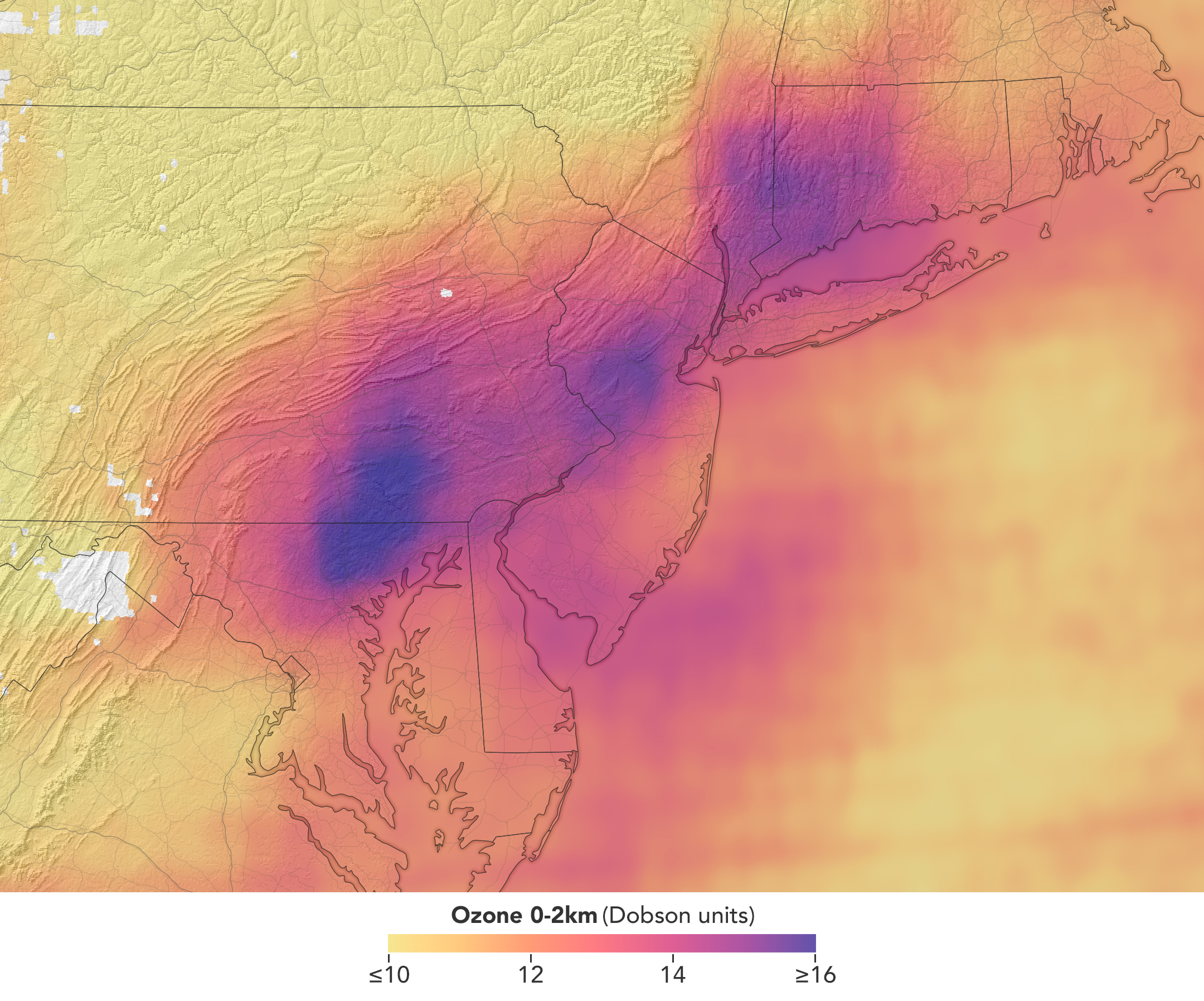
TEMPO detected elevated ozone concentrations in an area extending from New York City to Washington, D.C., at 5:05 p.m. on May 18, 2026.
NASA Earth Observatory/Michala Garrison
TEMPO also detects ozone directly, but determining how much of that ozone is near the surface versus higher in the atmosphere can be challenging. Most of Earth’s ozone resides in the stratosphere, well above the troposphere, where people live and breathe. At times, however, stratospheric ozone can be transported downward into the troposphere. During events known as stratospheric intrusions, it can even descend far enough to affect air quality at the surface and add to the ozone produced at ground level.
By combining TEMPO observations with other sources of information, researchers are studying the processes that influence the distribution of ozone vertically in the atmosphere. On May 18, NASA’s ground-based tropospheric lidar network (TOLNet) in New York City recorded high concentrations of ozone near the surface, indicating that TEMPO was detecting mostly surface-level ozone associated with urban emissions and not ozone aloft, said Mahmoud.
However, on May 19, the same sensor observed a layer of ozone descending from above 5 kilometers (3 miles), he added, a clue that some of the ozone TEMPO detected that day may have originated in the stratosphere. “This is the type of information that leads to better air quality forecast models and more accurate alerts,” Mahmoud said. “Alerts can affect tens of millions of people and lead to disruptions in school, sports, and other activities, so it’s essential that they be as accurate as possible.”
On June 6, New York authorities issued another health advisory for ozone. People interested in following the event can access daily near-real-time TEMPO observations of ozone, nitrogen dioxide, and other gases on NASA’s Worldview browser, on an interactive Harvard & Smithsonian Center for Astrophysics browsing tool, and on NASA’s Earthdata portal.
NASA Earth Observatory images by Michala Garrison, using TEMPO data from NASA Earthdata.Story by Adam Voiland.
TEMPO detected high concentrations of nitrogen dioxide during the morning commute at 7:05 a.m. local time on May 18, 2026 (left), along the New York-Washington corridor. The instrument detected lower levels of the gas at 3:05 p.m. (right), after chemical reactions involving nitrogen dioxide had contributed to elevated ozone concentrations in the afternoon.
NASA Earth Observatory/Michala Garrison
7:05 am
3:05 pm
TEMPO detected high concentrations of nitrogen dioxide during the morning commute at 7:05 a.m. local time on May 18, 2026 (left), along the New York-Washington corridor.The instrument detected lower levels of the gas at 3:05 p.m. EDT (right), after chemical reactions involving nitrogen dioxide had contributed to elevated ozone concentrations in the afternoon. NASA Earth Observatory images by Michala Garrison.
More than 35 million people live along the New York–Washington corridor and breathe the region’s air. While air quality has improved significantly in recent decades, outbreaks of ground-level ozone remain common, particularly in the warm summer months, when the chemical reactions that produce the pollutant accelerate and stagnant air allows ozone to accumulate.
A reminder of this seasonal phenomenon came earlier than usual in 2026, when a mid-May heat wave prompted the New York State Department of Health and the New York Department of Environmental Conservation to issue a health advisory on May 17 over concerns about ozone. The code orange advisory warned young people, older adults, and those working or exercising outdoors to limit activity due to ozone’s respiratory and cardiovascular health impacts.
As expected, ground-based air-quality sensors operated by state and federal agencies showed ozone reaching unhealthy levels for sensitive groups on May 18, something that typically happens several times per year. Meanwhile, NASA’s TEMPO (Tropospheric Emissions: Monitoring of Pollution) instrument observed the event from geostationary orbit 22,000 miles (35,000 kilometers) above the equator, a unique vantage point that allows the sensor to collect frequent observations of air pollution.
TEMPO detects nitrogen dioxide (NO2), a gas emitted by burning fuels, particularly by motor vehicles, that contributes to ozone formation. “There’s often a clear and interesting pattern in TEMPO’s nitrogen dioxide data during ozone alert days,” said Hazem Mahmoud, an atmospheric scientist at NASA’s Atmospheric Science Data Center at Langley Research Center. “We see high concentrations of nitrogen dioxide during the early morning commute that drop off sharply in the late afternoon as ozone increases.”
The decline occurs as sunlight fuels photochemical reactions involving nitrogen dioxide, volatile organic compounds, and oxygen that lead to ozone formation. By late afternoon, these reactions deplete much of the available nitrogen dioxide, slowing ozone production until the cycle begins again the next day.
The pair of images above underscores the pattern. The image on the left was acquired at 7:05 a.m. local time when nitrogen dioxide concentrations were high during the morning commute. By 3:05 p.m. (right), most of the nitrogen dioxide had declined substantially, and surface ozone levels were elevated (below). Meanwhile, afternoon sea breezes appear to have transported the remaining nitrogen dioxide slightly to the west. Note that the data shown is provisional, and processing methods are still being refined.
Sensors on earlier polar-orbiting satellites, such as OMI (Ozone Monitoring Instrument) and TROPOMI (Tropospheric Monitoring Instrument), sampled nitrogen dioxide over New York once per day. After its launch in 2023, TEMPO began providing data every hour, allowing researchers to track the evolution and dispersion of air pollution at much finer time scales.
“TEMPO is helping fill data gaps between ground stations and allowing us to ask new questions,” Mahmoud said. The mission provides data that can improve not only air quality forecasts during crisis situations, such as wildfires, but also the atmospheric models used to forecast the daily rhythms of urban pollution. Such models help researchers understand how natural factors such as winds, humidity levels, and air temperatures influence pollution plumes over the course of a day.
TEMPO detected elevated ozone concentrations in an area extending from New York City to Washington, D.C., at 5:05 p.m. on May 18, 2026.
NASA Earth Observatory/Michala Garrison
TEMPO also detects ozone directly, but determining how much of that ozone is near the surface versus higher in the atmosphere can be challenging. Most of Earth’s ozone resides in the stratosphere, well above the troposphere, where people live and breathe. At times, however, stratospheric ozone can be transported downward into the troposphere. During events known as stratospheric intrusions, it can even descend far enough to affect air quality at the surface and add to the ozone produced at ground level.
By combining TEMPO observations with other sources of information, researchers are studying the processes that influence the distribution of ozone vertically in the atmosphere. On May 18, NASA’s ground-based tropospheric lidar network (TOLNet) in New York City recorded high concentrations of ozone near the surface, indicating that TEMPO was detecting mostly surface-level ozone associated with urban emissions and not ozone aloft, said Mahmoud.
However, on May 19, the same sensor observed a layer of ozone descending from above 5 kilometers (3 miles), he added, a clue that some of the ozone TEMPO detected that day may have originated in the stratosphere. “This is the type of information that leads to better air quality forecast models and more accurate alerts,” Mahmoud said. “Alerts can affect tens of millions of people and lead to disruptions in school, sports, and other activities, so it’s essential that they be as accurate as possible.”
On June 6, New York authorities issued another health advisory for ozone. People interested in following the event can access daily near-real-time TEMPO observations of ozone, nitrogen dioxide, and other gases on NASA’s Worldview browser, on an interactive Harvard & Smithsonian Center for Astrophysics browsing tool, and on NASA’s Earthdata portal.
NASA Earth Observatory images by Michala Garrison, using TEMPO data from NASA Earthdata.Story by Adam Voiland.

 Login