❌

Normal view

“We Call It Weather Jiu-Jitsu”: Scientists Want to Fight Extreme Weather With Precision ‘Nudges’ Instead of Force

25 June 2026 at 18:04

Scientists from Arizona State University have performed computer simulations suggesting viable methods for controlling the weather by ‘nudging” systems in their development stages with proven technologies to mitigate or even completely avoid the damage from extreme weather events.

Although the new approach, which the team termed “Weather Jiu-Jitsu,” hasn’t been tested in real-world conditions, the researchers behind the new perspective paper outlining the process said it could help humans better prepare for severe weather systems by finding ways to live with nature rather than reacting to it.

Controlling the Weather Could Mitigate Property Damage and Loss of Life

When detailing their approach, ASU researcher Qin Huang and colleagues highlight the historical damage caused by extreme weather events, including floods, heat waves, droughts, and ‘freezes.’ In addition to the loss of life, estimates suggest that climate extremes caused $417 billion in damage in 2024 alone.

The paper’s authors also note that such extreme weather events “are increasing in frequency and intensity,” a trend research suggests is strongly driven by rising global temperatures. Although there have been some efforts to mitigate the effects of extreme weather, the paper’s authors write that increasing populations and continued climate change “heighten exposure to risks that conventional infrastructure cannot fully address.”

“The growing impact of weather extremes on society highlights that traditional approaches such as dams, levees, and insurance alone may not be sufficient to address the widespread consequences of these hazards,” the authors write.

To explore alternatives, the team wondered if small adjustments to burgeoning weather systems could redirect their paths or lessen their severity. In some ways, it’s like redirecting an incoming meteor to miss the Earth or hit it at a more oblique angle to lessen the impact.

“Imagine harnessing the power of nature to help steer hurricanes away from land, redirect atmospheric rivers to spread their rain safely and evenly, or defuse extreme weather patterns like heatwaves, freezes, or prolonged droughts before they take hold,” Huang and colleagues write. “It’s a vision where we partner with Earth’s own forces to create resilience, rather than reacting to disasters. We call it Weather Jiu-Jitsu.”

‘Nudging’ Weather System Trajectories with Weather Jiu-Jitsu

When detailing how the process would work, the team explained that Weather Jiu-Jitsu takes advantage of the “chaotic sensitivity of mid-latitude atmospheric dynamics to redirect destructive weather trajectories through small, precisely timed perturbations,” using forecasting models that project system paths and intensities.

“Our thesis is that Weather Jiu-Jitsu, i.e., adaptive chaos control applied to mid-latitude atmospheric dynamics, may provide a 21st century approach to managing a range of extreme weather events by nudging the system trajectories,” they explain.

Due to the challenges and risks of testing weather-control methods in real-world conditions, the researchers developed proof-of-concept computer simulations. Critically, their approach used established models of atmospheric circulation and a large-scale artificial intelligence “deep-learning Earth system” model, Aurora, designed to predict weather at high resolution.

According to the team’s research, carefully timed seeding of clouds could have major impacts on a storm’s path and intensity, noting that “nudges applied days before peak impact can shift a hurricane track to avoid landfall on a major city, weaken the peak intensity of a blocking-driven cold extreme, and reduce atmospheric river moisture transport under favorable upstream conditions.”

When testing their weather control approach on historically extreme climate events, the results were significant. For example, the team found that small, carefully timed cloud seeding operations applied in the critical days before the peak of an extreme weather event “could have shifted the track of the 2012 Hurricane Sandy by about 300 miles to miss New York City.”

The model also indicated that a similar approach could have raised the lowest temperature extremes experienced during the 2021 Texas freeze “by about 18 degrees Fahrenheit.” Similarly, the model revealed that the approach could have reduced the damaging precipitation levels associated with the 2022 atmospheric river that caused flooding in California by about 5%.

“By leveraging the atmosphere’s inherent sensitivity, Weather Jiu-Jitsu seeks not to overpower nature, but to collaborate with it: nudging storm tracks, influencing jet stream meanders, and possibly mitigating compound extremes before they fully develop,” the authors explain.

Revolutionizing the Risk from Extreme Climate Events

When discussing the potential impacts of controlling the weather before serious damage can occur, the study authors noted that it would be “transformative” for the planet. They also noted that controlling the weather could offer an outsized benefit to the most vulnerable people “who do not have recourse to other protections from weather extremes.”

Still, they add that demonstrating the real-world benefits of their approach to controlling the weather while accounting for “natural variability” will require evidence of tangible outcomes. The suggestion is that these metrics would include “reductions in peak precipitation intensity, flood inundation extent, and insured economic losses.”

To achieve this goal, Huang and colleagues recommended a three-stage approach. In the near term, they suggested starting with “controlled deep-learning perturbation experiments” for historical extreme events like floods and droughts, and air them with an “observational system design.” In the medium term, Huang and colleagues suggested implementing “scaled regional pilot studies” and developing a “governance framework development with WMO and UNEP.” The final proposed phase involved limited operational pilot experiments in select locations “under formal international oversight with systematic outcome monitoring.”

“We outline an argument that control over catastrophic weather extremes is imperative to reduce exposure to catastrophic events that are not mitigated by traditional physical, financial, or social infrastructure, and explore conditions under which this may be feasible,” the authors conclude. “If such an approach were successful, it could revolutionize hydroclimatic risk mitigation.”

The study “Weather Jiu-Jitsu: Prospects for atmospheric nudging to defuse the impact of catastrophic weather extremes” was published in PLOS Water.

Christopher Plain is a Science Fiction and Fantasy novelist and Head Science Writer at The Debrief. Follow and connect with him on X, learn about his books at plainfiction.com, or email him directly at christopher@thedebrief.org.

Low Water at San Carlos Reservoir

17 June 2026 at 05:01
June 7, 2023
May 22, 2026
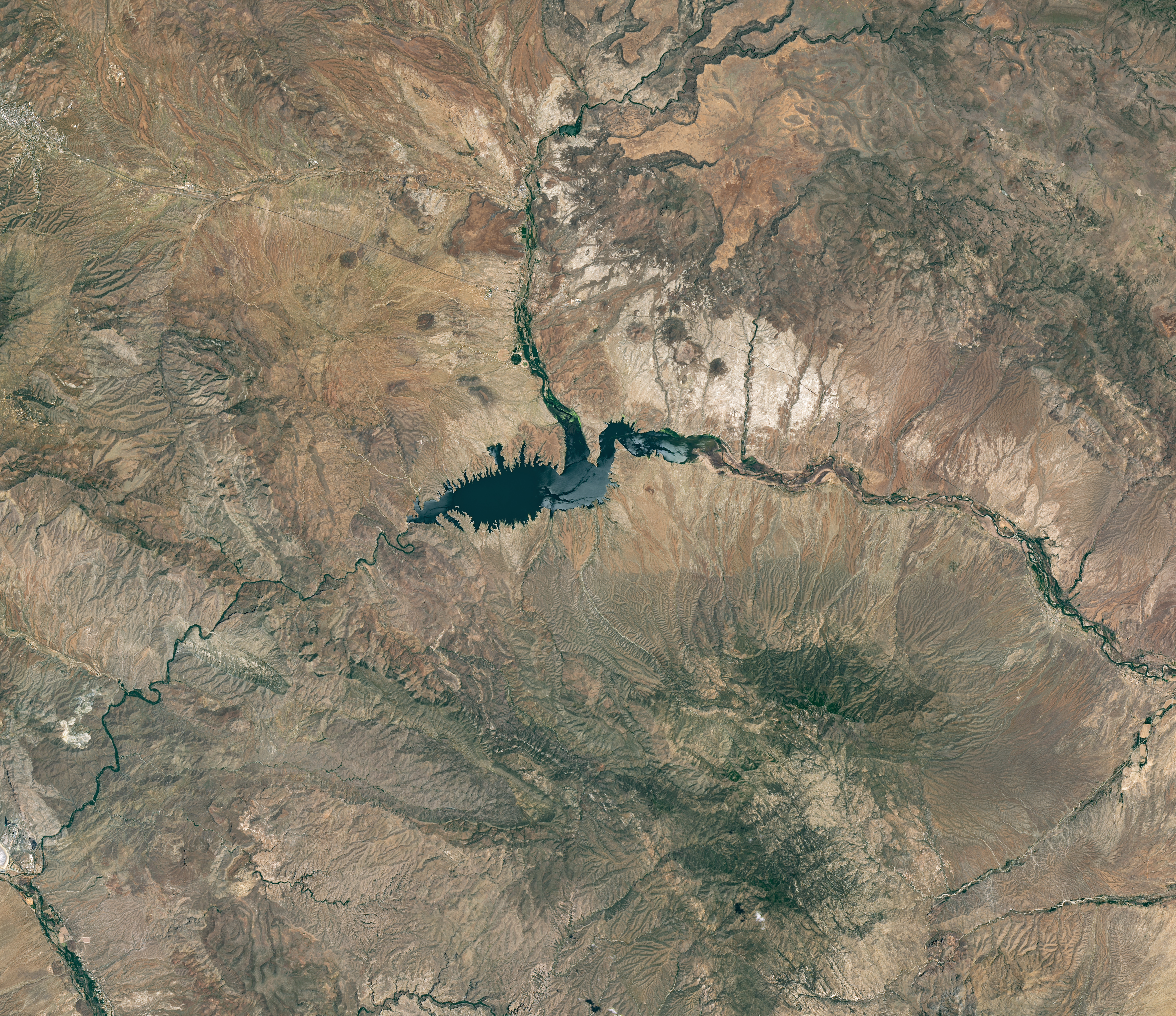
The reservoir appears lake-like and expansive in an image acquired in June 2023.
NASA Earth Observatory/Michala Garrison
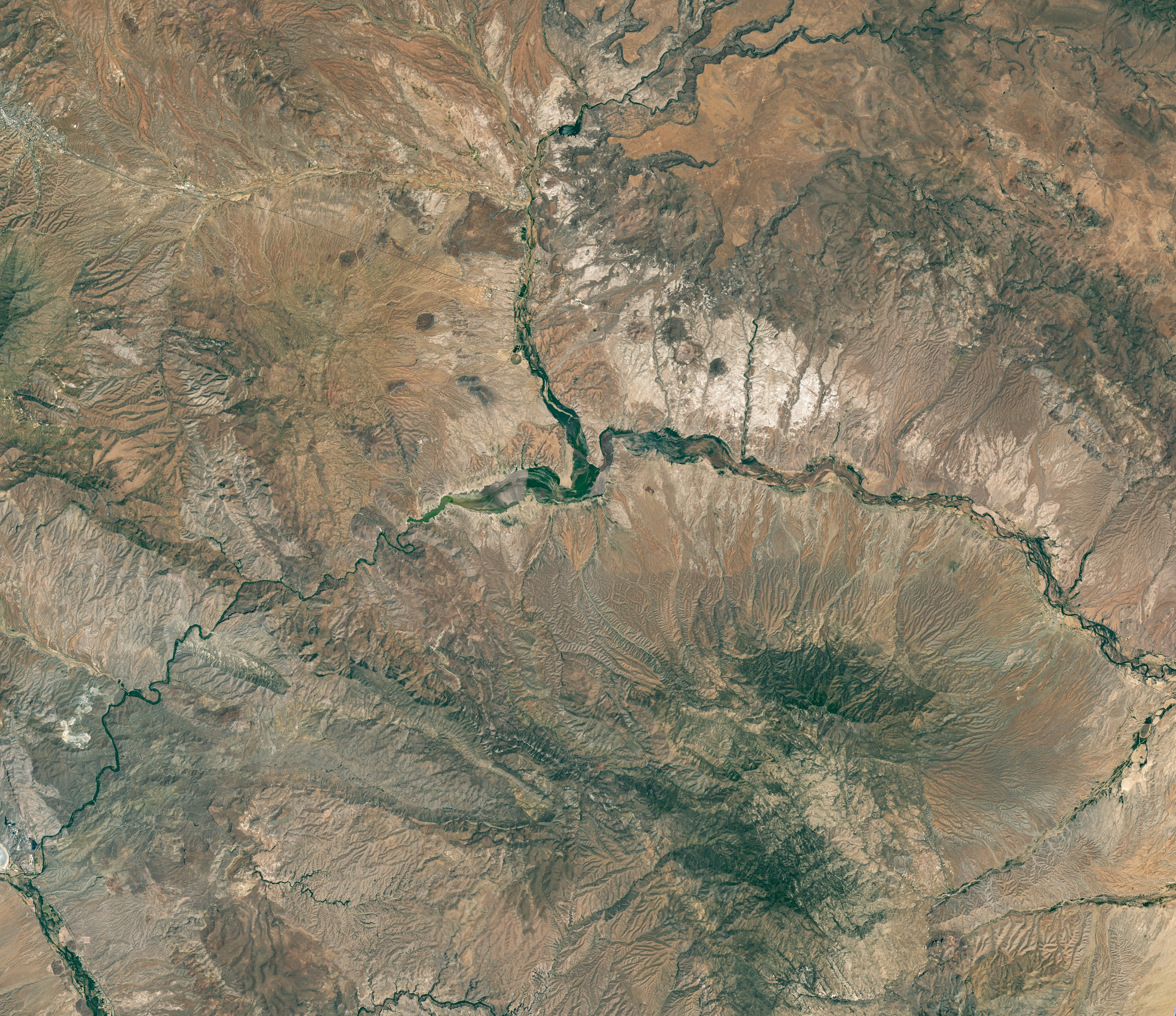
The reservoir is nearly empty by May 2026. The Gila River's natural channel is now visible and flanked with green vegetation in what had been the bottom of the reservoir.
The reservoir is nearly empty by May 2026. The Gila River’s natural channel is now visible and flanked with green vegetation in what had been the bottom of the reservoir.
NASA Earth Observatory/Michala Garrison
June 7, 2023
May 22, 2026
Little water remains in the San Carlos Reservoir in May 2026 (right) compared to fuller conditions in June 2023 (left). Images were captured by the OLI (Operational Land Imager) on the Landsat 9 and 8 satellites, respectively. NASA Earth Observatory images by Michala Garrison.

The Gila River is among the Southwest’s most important rivers, delivering water for people, farms, and wildlife while linking the snow-fed mountains of southwestern New Mexico to the desert lowlands of southwestern Arizona.

In wetter years, seasonal snowfall on the Mogollon Mountains and Black Range provides much of the river’s spring flow and helps refill San Carlos Reservoir, which is formed by the Coolidge Dam. When filled to capacity, the reservoir is one of Arizona’s largest bodies of water.

However, in 2026, lackluster snowfall left the mountain snowpack in the Gila River watershed at 2 percent of the 1991-2020 March median. The limited snowpack pushed April streamflow to 39 percent of normal. By June, after mandatory water releases for downstream agriculture, the reservoir held less than 400 acre-feet of water.

The Landsat image above (right) shows the near-empty reservoir on May 22, 2026, when it stored 389 acre-feet of water—less than 1 percent full; the other image (left) shows the same area in June 2023, when it was about 60 percent full. The green vegetation growing along the river channel and reservoir edge includes a mixture of tamarisk, willow, cottonwood, sedges, and grasses.

Officials closed the reservoir indefinitely on June 5, 2026, after the declining water levels contributed to low oxygen levels—hypoxia—that killed virtually all of its fish. Species living in the reservoir included largemouth bass, black crappie, bluegill, channel catfish, flathead catfish, and several stocked species, including brown trout and rainbow trout. The decomposing fish may pose health risks to people attempting to boat or fish, the San Carlos Recreation and Wildlife Department warned.

The reservoir has hit similarly low water levels in the past, running out of water at least 20 times since it was filled in 1930, according to news reports. Even when the dam and reservoir were first dedicated, there was enough grass growing on the dried reservoir bottom that humorist Will Rogers famously quipped to President Calvin Coolidge: “If that was my lake, I’d mow it.”

Other years with major fish kills include 1976 and 2018. After more than 5 million fish died during a similar event in 1976, the Gila Herald reported that it took five years for the lake’s ecosystem to rebound.

The region is currently in the midst of a multi-year dry period that has left much of the Gila River’s headwaters in New Mexico in a state of severe drought, according to data from the U.S. Drought Monitor.

However, the river’s flow is highly variable, and heavy rains during the coming wet season could help the reservoir recover. A seasonal monsoon outlook released by NOAA in May 2026 projected a 33 to 50 percent chance that an above-average amount of rain would fall in the region that summer. El Niño in the central and eastern equatorial Pacific, which was strengthening in late spring 2026, can make heavy rains in the U.S. Southwest more likely.

NASA Earth Observatory images by Michala Garrison, using Landsat data from the U.S. Geological Survey. Story by Adam Voiland.

Downloads

The reservoir appears lake-like and expansive in an image acquired in June 2023.

June 7, 2023

JPEG (16.60 MB)

The reservoir is nearly empty by May 2026. The Gila River's natural channel is now visible and flanked with green vegetation in what had been the bottom of the reservoir.

May 22, 2026

JPEG (16.85 MB)

References & Resources

You may also be interested in:

Stay up-to-date with the latest content from NASA as we explore the universe and discover more about our home planet.

Drought Parches Florida
4 min read

The state was unusually dry for much of 2025, but the intensity of the drought has ratcheted up since January…

Article
Snow Is Scarce in the Upper Colorado Basin
5 min read

The mountains of Utah and Colorado are among the areas of the western U.S. that are low on snow and…

Article
Spring Rains Saturate Michigan
3 min read

Above-normal precipitation has swollen rivers and damaged infrastructure statewide.

Article

The post Low Water at San Carlos Reservoir appeared first on NASA Science.

Low Water at San Carlos Reservoir

17 June 2026 at 05:01


June 7, 2023
May 22, 2026

The reservoir appears lake-like and expansive in an image acquired in June 2023.
NASA Earth Observatory/Michala Garrison

The reservoir is nearly empty by May 2026. The Gila River's natural channel is now visible and flanked with green vegetation in what had been the bottom of the reservoir.
The reservoir is nearly empty by May 2026. The Gila River’s natural channel is now visible and flanked with green vegetation in what had been the bottom of the reservoir.
NASA Earth Observatory/Michala Garrison

The reservoir appears lake-like and expansive in an image acquired in June 2023.
NASA Earth Observatory/Michala Garrison
The reservoir is nearly empty by May 2026. The Gila River's natural channel is now visible and flanked with green vegetation in what had been the bottom of the reservoir.
The reservoir is nearly empty by May 2026. The Gila River’s natural channel is now visible and flanked with green vegetation in what had been the bottom of the reservoir.
NASA Earth Observatory/Michala Garrison

June 7, 2023

May 22, 2026


Little water remains in the San Carlos Reservoir in May 2026 (right) compared to fuller conditions in June 2023 (left). Images were captured by the OLI (Operational Land Imager) on the Landsat 9 and 8 satellites, respectively. NASA Earth Observatory images by Michala Garrison.

The Gila River is among the Southwest’s most important rivers, delivering water for people, farms, and wildlife while linking the snow-fed mountains of southwestern New Mexico to the desert lowlands of southwestern Arizona.

In wetter years, seasonal snowfall on the Mogollon Mountains and Black Range provides much of the river’s spring flow and helps refill San Carlos Reservoir, which is formed by the Coolidge Dam. When filled to capacity, the reservoir is one of Arizona’s largest bodies of water.

However, in 2026, lackluster snowfall left the mountain snowpack in the Gila River watershed at 2 percent of the 1991-2020 March median. The limited snowpack pushed April streamflow to 39 percent of normal. By June, after mandatory water releases for downstream agriculture, the reservoir held less than 400 acre-feet of water.

The Landsat image above (right) shows the near-empty reservoir on May 22, 2026, when it stored 389 acre-feet of water—less than 1 percent full; the other image (left) shows the same area in June 2023, when it was about 60 percent full. The green vegetation growing along the river channel and reservoir edge includes a mixture of tamarisk, willow, cottonwood, sedges, and grasses.

Officials closed the reservoir indefinitely on June 5, 2026, after the declining water levels contributed to low oxygen levels—hypoxia—that killed virtually all of its fish. Species living in the reservoir included largemouth bass, black crappie, bluegill, channel catfish, flathead catfish, and several stocked species, including brown trout and rainbow trout. The decomposing fish may pose health risks to people attempting to boat or fish, the San Carlos Recreation and Wildlife Department warned.

The reservoir has hit similarly low water levels in the past, running out of water at least 20 times since it was filled in 1930, according to news reports. Even when the dam and reservoir were first dedicated, there was enough grass growing on the dried reservoir bottom that humorist Will Rogers famously quipped to President Calvin Coolidge: “If that was my lake, I’d mow it.”

Other years with major fish kills include 1976 and 2018. After more than 5 million fish died during a similar event in 1976, the Gila Herald reported that it took five years for the lake’s ecosystem to rebound.

The region is currently in the midst of a multi-year dry period that has left much of the Gila River’s headwaters in New Mexico in a state of severe drought, according to data from the U.S. Drought Monitor.

However, the river’s flow is highly variable, and heavy rains during the coming wet season could help the reservoir recover. A seasonal monsoon outlook released by NOAA in May 2026 projected a 33 to 50 percent chance that an above-average amount of rain would fall in the region that summer. El Niño in the central and eastern equatorial Pacific, which was strengthening in late spring 2026, can make heavy rains in the U.S. Southwest more likely.

NASA Earth Observatory images by Michala Garrison, using Landsat data from the U.S. Geological Survey. Story by Adam Voiland.

Downloads

The reservoir appears lake-like and expansive in an image acquired in June 2023.

June 7, 2023

JPEG (16.60 MB)

The reservoir is nearly empty by May 2026. The Gila River's natural channel is now visible and flanked with green vegetation in what had been the bottom of the reservoir.

May 22, 2026

JPEG (16.85 MB)

References & Resources

You may also be interested in:

Stay up-to-date with the latest content from NASA as we explore the universe and discover more about our home planet.

Drought Parches Florida

4 min read

The state was unusually dry for much of 2025, but the intensity of the drought has ratcheted up since January…

Article

Snow Is Scarce in the Upper Colorado Basin

5 min read

The mountains of Utah and Colorado are among the areas of the western U.S. that are low on snow and…

Article

Spring Rains Saturate Michigan

3 min read

Above-normal precipitation has swollen rivers and damaged infrastructure statewide.

Article
❌