Discover the cosmos! Each day a different image or photograph of our fascinating universe is featured, along with a brief explanation written by a professional astronomer.
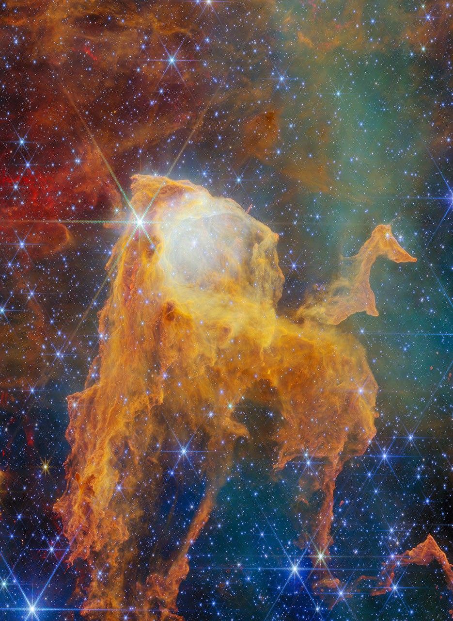
A Treasure Chest in the Carina Nebula
Explanation: This treasure chest is full of stars. The featured image was obtained with NASA‘s James Webb Space Telescope and shows a dust pillar in the Carina Nebula inside our Galaxy, roughly 7500 light-years away. It is formed by interstellar gas and dust, and shaped by powerful stellar winds and radiation from neighboring stars like the nearby Eta Carinae stellar system which is more luminous than 5 million suns. The star formation inside the pillar is excavating its head, creating the open lid of the chest. Astronomers estimate that there are about 70 stars in a compact cluster inside the pillar. This cluster is now thought to be only around 1.3 million years old. Its bounty of young stars includes a massive star approximately 19 times as massive as the Sun. More massive stars are rarer, shine brighter and evolve faster than less massive stars. They are the shiniest jewels in the treasure chest.
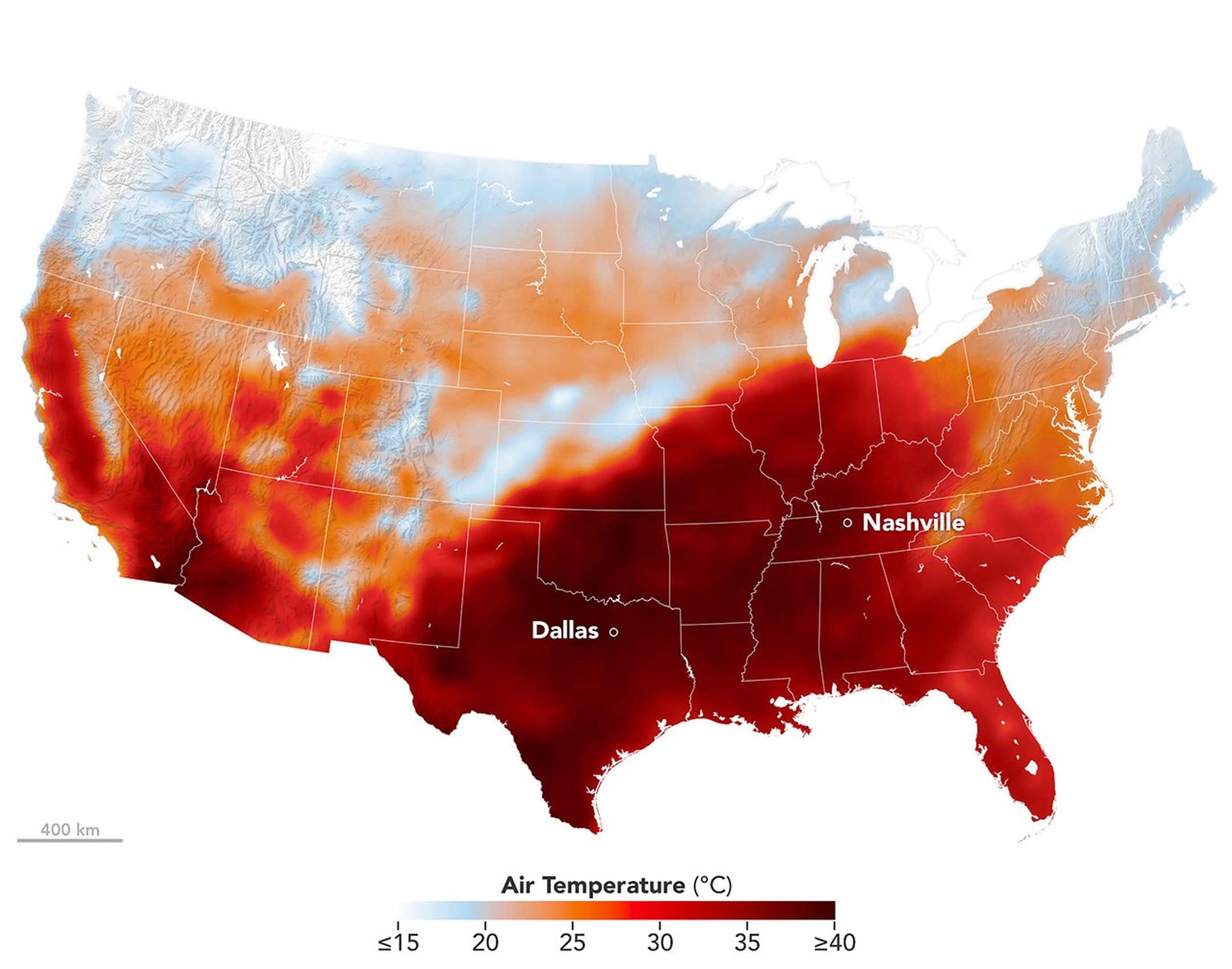
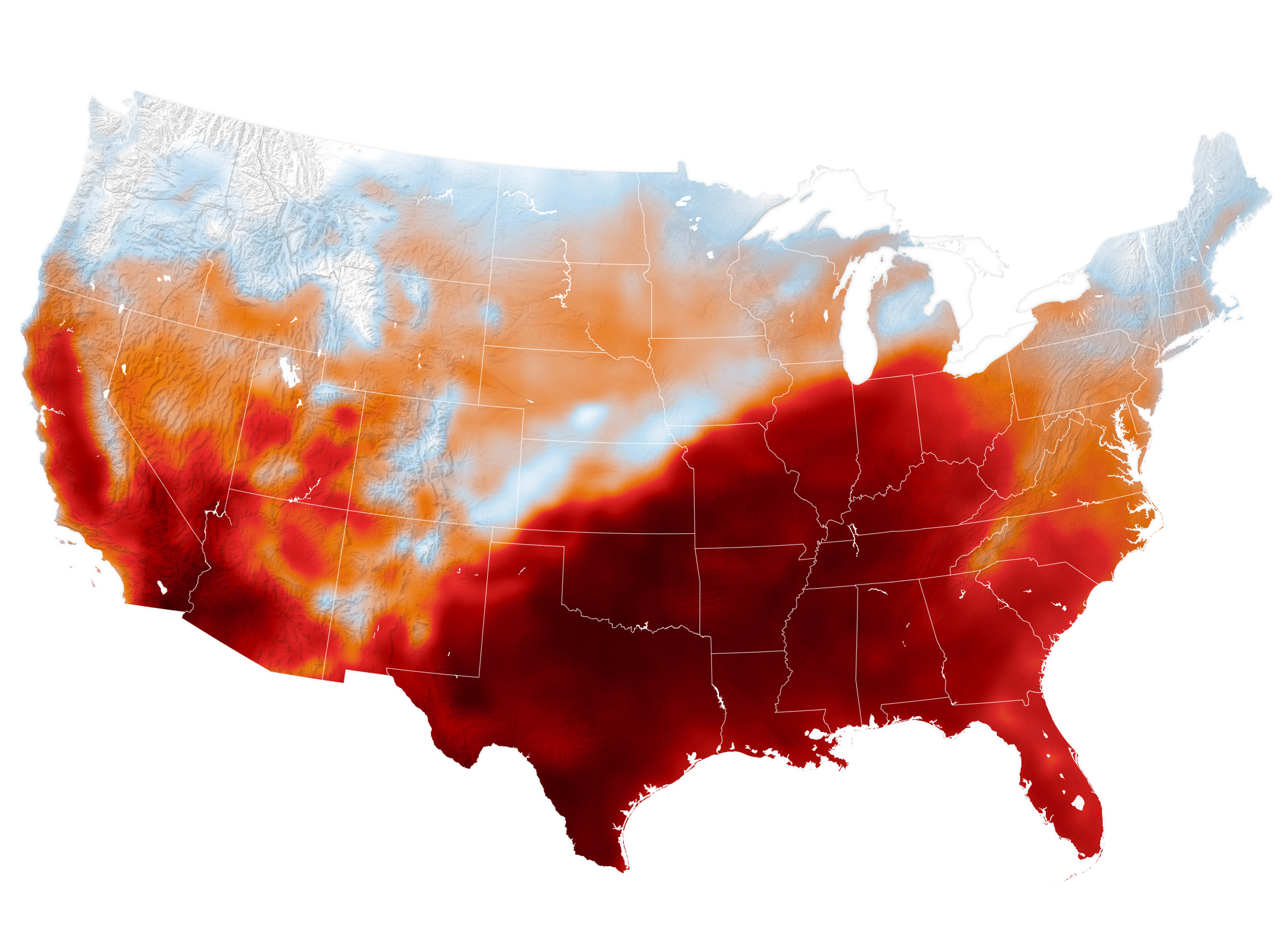
An area of high pressure over the south-central U.S. produced unseasonable and, in some places, record-breaking warmth on September 15, 2026, as shown in this map of modeled air temperatures from GEOS (Goddard Earth Observing System).
NASA Earth Observatory/Michala Garrison
While the calendar indicated that astronomical summer was winding down, a swath of the south-central United States was sweltering under a heat dome in mid-September 2026.
This map shows air temperatures in the contiguous U.S. on September 15, 2026, at 4 p.m. Central Time (21:00 Universal Time), modeled at 2 meters (6.5 feet) above the ground. It was produced by combining satellite observations with temperatures predicted by a version of the GEOS (Goddard Earth Observing System) model, which uses mathematical equations to represent physical processes in the atmosphere. The darkest reds indicate areas where temperatures approached or exceeded 40 degrees Celsius (104 degrees Fahrenheit).
More than 41 million people in the U.S.—about 12 percent of the population—were under a National Weather Service extreme heat advisory, extreme heat watch, or extreme heat warning on September 15. The high temperatures spanned large portions of several states, such as Texas, Oklahoma, Arkansas, Missouri, and Tennessee. Meteorologists warned that high humidity, limited cloud cover, and light winds could make temperatures feel higher than thermometer readings and increase the risk of heat-related illnesses.
Several locations set new daily high temperature records on September 15. These included Dallas, Texas, at 101ºF (38ºC), Memphis, Tennessee, at 99ºF (37ºC), and Nashville, Tennessee, at 100ºF (38ºC). The cities were all at least 12ºF warmer than normal that day, with Nashville breaking its daily-high record from 1927. The day before, Nashville also set a record-high minimum temperature of 75ºF (24ºC).
A weather phenomenon meteorologists call a heat dome was responsible for driving temperatures up across the region. A heat dome develops when an area of high pressure in the upper atmosphere pushes hot air toward the surface and traps it there. Heat domes put the brakes on convection and suppress clouds and precipitation. This allows sunlight to reach Earth’s surface relatively unhindered and further elevate air temperatures.
The stretch of unseasonable temperatures follows the warmest June through August in the contiguous United States in a 132-year record, according to NOAA. The three-month period in 2026 was 0.4ºF warmer than the previous records, set in 1936 and 2021.
Preparations for Next Moonwalk Simulations Underway (and Underwater)
Derek Abramson, Dale Reed Subscale Flight Research Laboratory chief engineer, left, communicates with the Edwards Air Force Base air traffic control tower for approval to fly the Alta-X drone near NASA’s Armstrong Flight Research Center in Edwards, California, on Thursday, Aug. 27, 2026. Justin Link, small uncrewed aircraft pilot, second from left, and laboratory chief pilot Justin Hall await flight clearance. Researchers at NASA’s Johnson Space Center in Houston developed the advanced guidance and navigation system known as the Safe and Precise Landing – Integrated Capabilities Evolution (SPLICE) experiment, which is installed on the Alta-X. SPLICE will help spacecraft land precisely and detect and avoid potential hazards, which is critical for NASA missions to the Moon and to Mars.
NASA/Ryan Kline
Long before they helped shape NASA’s future aerospace breakthroughs, Derek Abramson, Justin Hall, and Justin Link were in their garages and homes building radio‑controlled aircraft, testing new ideas, and flying their creations at hobby events. That early passion now fuels the work of NASA’s Dale Reed Subscale Flight Research Laboratory at the agency’s Armstrong Flight Research Center in Edwards, California.
At NASA Armstrong’s subscale flight lab, the team turns that lifelong enthusiasm into mission-focused innovation. The laboratory supports research that ranges from advanced navigation systems for future landings on the Moon and Mars to emerging aeronautics concepts that need quick, low-cost evaluation. NASA’s small, remotely piloted and autonomous aircraft allow engineers to explore ideas that could be difficult, risky or expensive to test at full scale.
Skilled team
Abramson, Hall, and Link play key roles in that work. Abramson serves as the laboratory’s chief engineer. Hall is the chief pilot. Link is a drone pilot. Together, they integrate emerging aerospace technologies with the lab’s subscale aircraft fleet and, when needed, design and build aircraft or flight experiments to evaluate new concepts.
Derek Abramson, chief engineer at the Dale Reed Subscale Flight Research Laboratory at NASA’s Armstrong Flight Research Center in Edwards, California, is shown with his Kalt Cyclone radio-controlled helicopter in the mid-1980s. Abramson loved flying this aircraft as a child, and he has been an aviation enthusiast for as long as he can remember.
Derek Abramson
Abramson’s expertise, built through service in the U.S. Navy and the aerospace industry, centers on technical oversight, management, and system design. Hall is known for creative approaches to problem solving and uses practical methods to address technical challenges and maintain flight safety. Link specializes in designing and fabricating research vehicles and draws on extensive hands-on experience to understand what works, and what does not, in flight.
On weekends, the team often tinkers in their garages or hangars building radio-control aircraft, researching hobby trends, or exploring new technologies. You might see them flying their creations at hobby events or attending trade shows. Their passion for flight brought Abramson, Hall, and Link together years before they one-by-one joined NASA more than a decade ago, though each discovered that spark in a different way.
Early influences
Abramson’s interest began as a child with rubber-band powered stick and tissue aircraft and radio-controlled models. His early aviation pursuits led to his first solo flight while in high school and a pilot’s license. In the Navy, he worked on multiple aircraft, including EA-6B and the F-18, as an avionics technician. As an engineer, he supported the B-1 and CV-22 Osprey aircraft flight tests. As an intern at NASA Armstrong, he used his operational and engineering experience on remotely piloted and autonomous aircraft.
Hall’s interest grew after seeing historic aircraft including the Mach 3 SR-71 fly over his elementary school playground and watching Space Shuttle Challenger land from above his dad’s shoulders. He has built and flown model and remotely piloted aircraft for as long as he can remember. His reputation flying radio-controlled hobby aircraft at fly-ins and trade events led to an offer to fly subscale aircraft at NASA.
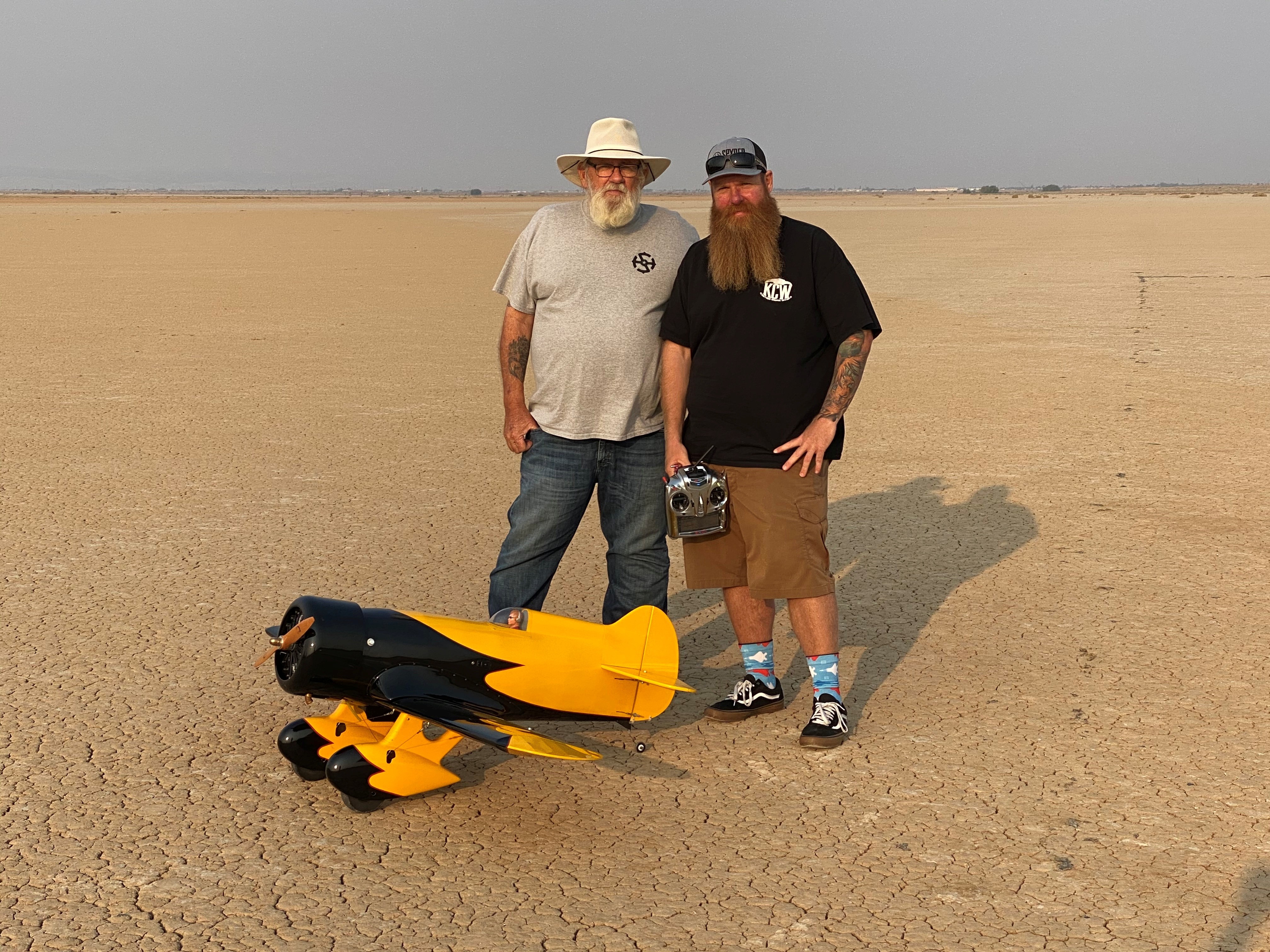
Justin Hall, chief pilot at the Dale Reed Subscale Flight Research Laboratory at NASA’s Armstrong Flight Research Center in Edwards, California, stands in front of a radio-controlled aircraft with his dad, David Hall, in August 2020. David Hall built the Gee Bee aircraft years earlier but was unable to fly it due to his health. He asked his son to fly the aircraft so he could see it in the air, which Justin did the day of this photo. Shortly afterward, David Hall passed away.
Justin Hall
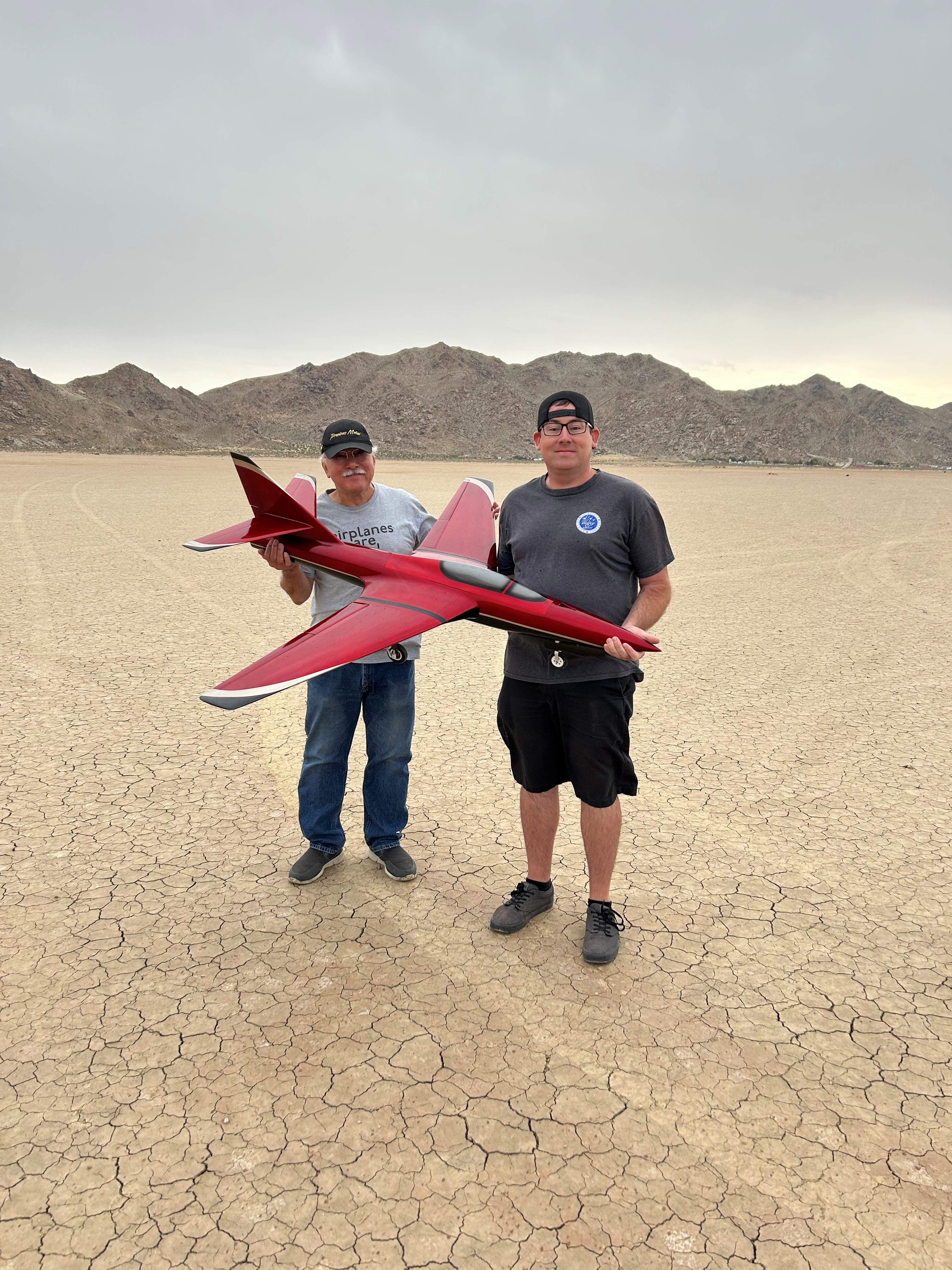
Justin link, drone pilot at the Dale Reed Subscale Flight Research Laboratory at NASA’s Armstrong Flight Research Center in Edwards, California, and his dad, Don Link, hold a Firebird radio-controlled aircraft on the day of its first flight in September 2023. It was a project they worked on together. Don Link reduced the dimensions of the original larger-scale model aircraft and drew the plans, while Justin Link manufactured composite molds and built the aircraft from scratch.
Justin Link
Link was five years old when he built balsa-wood aircraft with his dad and flew them in a field near their home. As he grew older, his hobby expanded to include radio-controlled cars, boats, helicopters, and aircraft. Aviation runs deep in Link’s family. His great grandfather served in the U.S. Army Air Corps, his grandfathers served in the U.S. Air Force, and his dad was an Air Force avionics technician. Link raced sailplanes, competed with scaled warbird aircraft, and was encouraged by family and friends to pursue an aviation profession. He has worked with large drones for more than 11 years, focusing on research and development, composite materials, and specialized fabrication methods.
Together, the team applies its experience and knowledge in rapid design, fabrication, integration and flight testing to bring new ideas to flight. Their work continues to support NASA’s missions across aeronautics, science, and exploration.
A zoomed-in view of the Moon made from images from NASA’s Lunar Reconnaissance Orbiter Camera. (More information at the bottom of article.)
Credits: NASA Goddard/Intuitive Machines/Robert Wagner
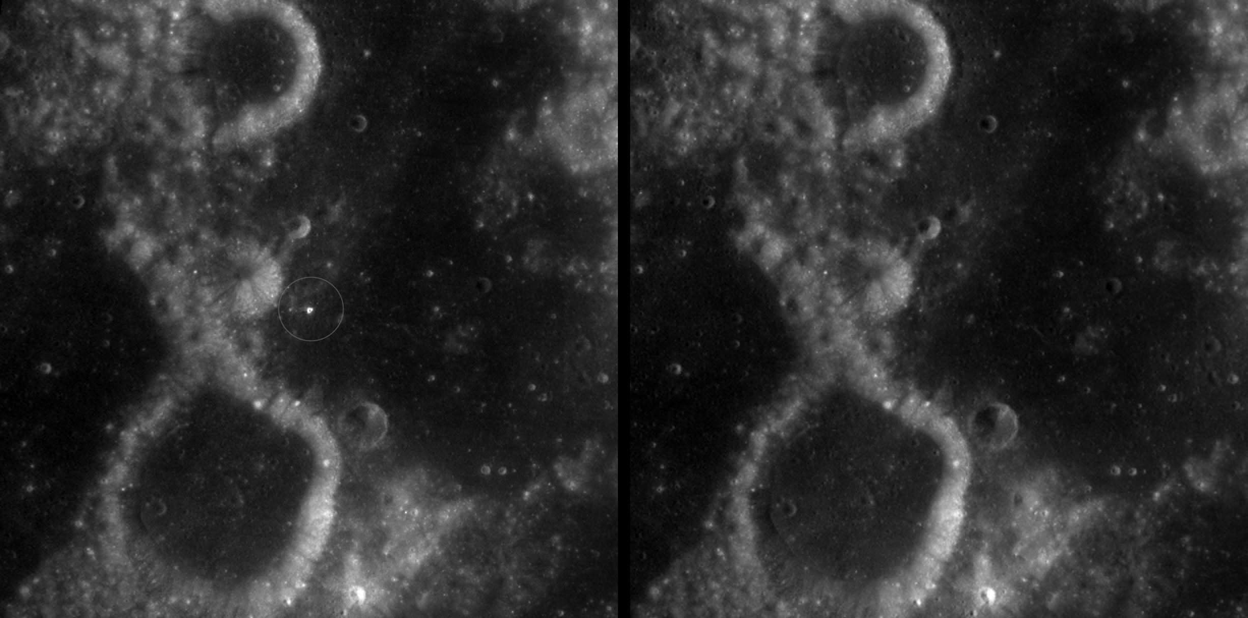
It started as a routine data-quality check. But as Robert Wagner, a scientist with NASA’s Lunar Reconnaissance Orbiter (LRO), scanned a giant Moon map on his computer screen, an unusually large bright spot circled by a dark halo caught his eye, as it implied that surface material in that area had been shaken up.
“I just stopped, dropped everything, and started looking into what that spot was,” said Wagner, an image-processing specialist from Intuitive Machines who works with data from the Lunar Reconnaissance Orbiter Camera (LROC) system.
By comparing before and after images of the Moon, Wagner realized he had discovered the largest, newly formed crater ever found in the solar system, as scientists reported Wednesday in Science Advances. This discovery highlights the value of NASA’s Moon orbiter data in studying a dynamic landscape as the agency advances a sustained human presence and expanded scientific and commercial activity on the Moon.
A zoomed-in view of McGetchin crater, circled on the left, next to a “before” image on the right. The panel on the left is made from images captured by NASA’s Lunar Reconnaissance Orbiter Wide-Angle Camera in summer 2025; the right panel was made from images taken in spring 2011. The white spot is not the crater itself, but rather material flung out of the crater, which formed when a rock, possibly this size of a three- to six‑story building, crashed into the Moon between April 11 and May 22, 2024 – a once-in-a-century event, as scientists reported on Sept. 15, 2026, in a pair of papers in Science Advances. The area shown in the images is 38 miles wide.
NASA Goddard/Intuitive Machines/Robert Wagner
Officially named McGetchin after pioneering lunar scientist Tom McGetchin, the crater formed on the Moon’s eastern edge sometime between April 11 and May 22, 2024, after a comet or asteroid the size of a three- to six-story building hit the surface.
The crash left a crater, 728 feet wide, that spans the length of two football fields. And at 141 feet deep, the crater could fit three vertically stacked yellow school buses.
Scientists estimate that an impact of this magnitude happens on the Moon about once in a century or even longer.
Moon takes some hits
For more than 17 years, LRO has been circling the Moon and using its seven instruments to map the topography, surface composition, temperature, and radiation environment there. The spacecraft’s team has identified at least 1,000 new impact craters throughout the mission and flagged 100,000 more surface changes from an object smashing into the Moon or from the debris that flung out after.
With no atmosphere to slow them or burn them up, space rocks and other objects easily reach the lunar surface. Most are much smaller compared to the object that carved out McGetchin crater. The smallest craters scientists can distinguish from LRO images are about 30 feet wide, the length of a three-story building laid on its side, made by rocks about 43 inches wide, the size of a monster-truck tire. Scientists estimate that impacts of this scale produce about 140 new craters across the Moon each year. But most new ones are made by microscopic projectiles that leave holes too small to identify in orbital images.
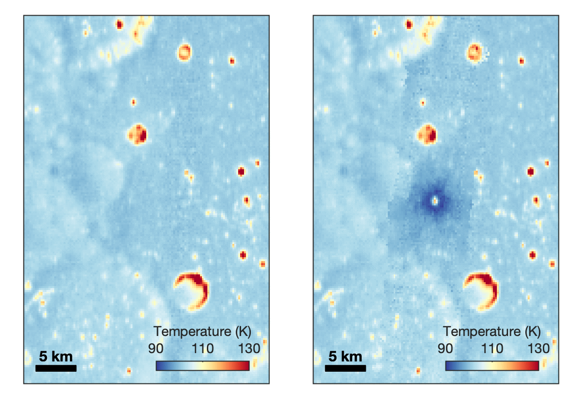
With its numerous instruments, the spacecraft can observe changes to the lunar surface that aren’t apparent in the LROC images alone. After the crater was discovered, scientists working with LRO’s thermal instrument, Diviner, made follow-up observations of the site. They found a 4-mile-wide area around the crater that is about 16 degrees Fahrenheit cooler at night than its surroundings.
This animated image set shows an area on the eastern limb of the Moon before and after McGetchin crater formed there sometime between April 11 and May 22, 2024. The post-impact image was constructed using data taken by NASA’s Lunar Reconnaissance Orbiter (LRO) thermal instrument, Diviner, between Nov. 15, 2025, and Feb. 18, 2026, after scientists discovered the crater in visible-light images taken by LRO’s Wide-Angle Camera. Pre-impact temperatures are from the Diviner Global High-Resolution Mosaics (GHRM). The crater formed on the Moon after a comet or asteroid, possibly the size of a six-story building, hit the surface in a rare, once-in-a-century collision. The dark blue strip that flashes into view reveals a 4-mile-wide “cold spot” around the crater that is about 16 degrees Fahrenheit cooler at night than its surroundings. This cooling happens because an impact fluffs up regolith around a crater, making it less dense and therefore less able to retain heat. Scientists on the Diviner team reported this finding in a paper published on Sept. 16, 2026, in Science Advances. The red and yellow spots indicate areas typically associated with rocks excavated by long-ago impacts which, though still at cryogenic temperatures like their surroundings, remain slightly warmer at night.
NASA Goddard/UCLA/JHU APL
Reporting in a second paper Wednesday in the same journal, researchers say that the cooling happens because the impact fluffs up the regolith around the crater, making it less dense and therefore less able to retain heat.
The large extent of this “cold spot” is striking, scientists say, because it shows that impacts can modify the Moon’s surface far beyond the crater itself. These physical changes could affect how rover wheels interact with the surface, for instance.
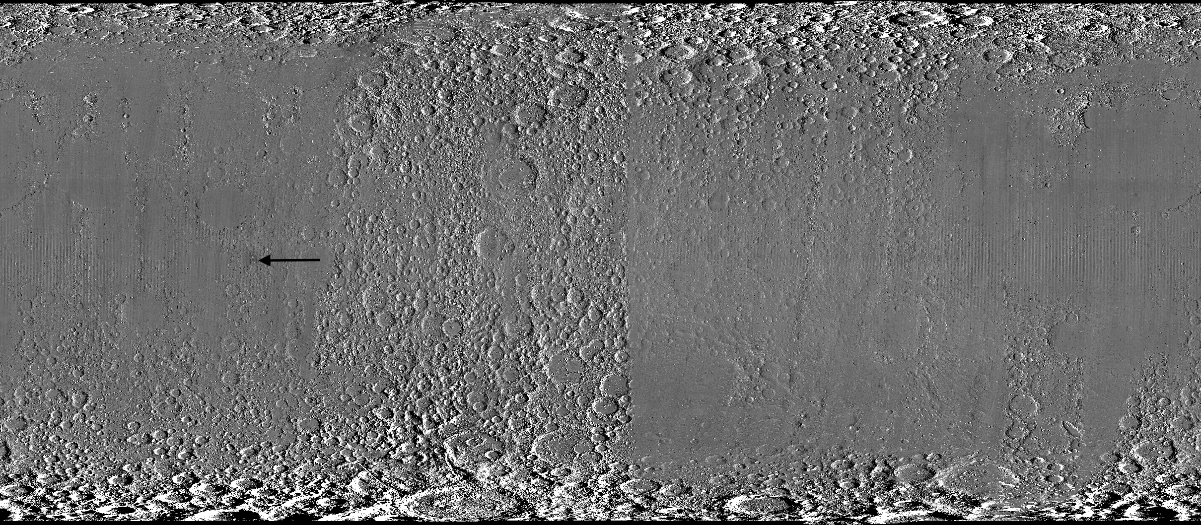
A global view of the Moon made by stitching together hundreds of images from the Wide-Angle Camera aboard NASA’s Lunar Reconnaissance Orbiter (LRO). Robert Wagner, image processing specialist for LRO, made this map using two sets of mages taken several years apart. He used a software designed to highlight any changes between the two sets. Anything that stayed the same turned gray; anything different showed up as bright or dark patches. A black arrow just left of center points to McGetchin crater.
NASA Goddard/Intuitive Machines/Robert Wagner
Road to discovery
The LROC system collects images from about 60 miles above the Moon as LRO loops from pole to pole. The system includes two cameras that capture high‑resolution black‑and‑white images and one camera for moderate‑resolution multispectral images. Over the years and thousands of passes, scientists have built maps detailed enough to spot not only new craters, but also landslides, landers, seismic faults, and even hints of lava tubes.
LROC scientists regularly analyze close-up images of small portions of the Moon’s surface taken by the Narrow-Angle Camera. Using these images, they look for changes that are typically less than 30 feet across. But every few years the team searches for large (wider than 150 feet) features by creating global Moon maps and comparing them to older versions.
An overhead, close-up view of McGetchin crater that was taken on Dec. 5, 2025, by NASA’s Lunar Reconnaissance Orbiter (LRO) Narrow-Angle Camera (NAC). After the crater was discovered on Oct. 24, 2025, in global images from LRO’s Wide-Angle Camera, which captures broad views with pixels the size of American football fields, scientists turned to the NAC, which takes much sharper views at about 3 feet per pixel. The NAC images, taken as LRO flew over the impact site again, revealed the crater size, shape, and how the surrounding terrain was affected by the impact that carved McGetchin. The image covers an area that’s ¾ mile wide.
NASA Goddard/Intuitive Machines
This view from the side (55° away from straight down) towards the east, covers an area of the Moon that’s about 1.5 miles wide. It was taken by NASA’s Lunar Reconnaissance Orbiter Narrow-Angle Camera on March 3, 2026.
NASA Goddard/Intuitive Machines
That’s what Wagner was doing on Oct. 24, 2025, when he came across McGetchin. Using images from LROC’s Wide-Angle Camera, which captures broad views with pixels the size of football fields, he stacked hundreds of “before” and “after” frames with software designed to highlight change. Anything that stayed the same turned gray while anything different showed up as bright or dark patches.
While the process sounds straightforward, spotting real craters requires a lot of manual work. The software flags every tiny shift in lighting or shadow, generating hundreds of false alarms. For this reason, Wagner typically verifies the software, looking for small fuzzy halos around pixel‑wide bright points, which indicate splashes of regolith around a new crater.
Spanning hundreds of pixels, McGetchin stood out immediately. “It was by far the most obvious impact debris pattern I’ve ever seen in one of these images,” Wagner said.
After his discovery, scientists turned to the Narrow-Angle Camera, which takes much sharper views at about 3 feet per pixel. This camera’s close-up images, taken as LRO flew over the impact site again, revealed the crater size, shape, and how the surrounding terrain was affected. These images also helped researchers estimate the size and force of the rock fragment that formed the new crater, details that are expected to appear in a future paper.
Banner image caption: A zoomed-in view of the Moon, with debris around McGetchin crater visible as a white spot circled by a dark halo just right of center of the image (marked with black arrows). This is the view that Robert Wagner saw on Oct. 24, 2025, during a routine data-quality check. Wagner is an image processing specialist for NASA’s Lunar Reconnaissance Orbiter Camera, a system of three cameras. Using images from the Wide-Angle Camera (WAC), which captures broad views with pixels the size of American football fields, he stacked hundreds of images captured by WAC over the last several years with software designed to highlight change. Anything that stayed the same is gray; anything that changed showed up as bright or dark patches. The stripes in the image are due to slight changes in lighting between the older and newer images. This image composite shows an area of the Moon approximately 900 miles across.
About the Author
Lonnie Shekhtman
Senior Science Writer
Shekhtman helps communicate NASA planetary science to the world through news and feature stories on NASA.gov, videos for NASA+ and YouTube, and by working with the media. She reports on lunar and Mars science and exploration; NASA’s search for life; missions to Venus, Titan, and Jupiter’s Trojan asteroids; and many other topics related to NASA’s exploration of our solar system and beyond.
Scientists discovered a crater on the Moon that formed sometime between April 11 and May 22, 2024, after a comet or asteroid the size of a three- to six-story building hit the surface.
The crash left a crater, 728 feet wide, that spans the length of two football fields. And at 141 feet deep, the crater could fit three vertically stacked yellow school buses.
On Sept. 10, 2026, NASA commemorated the completed repairs of the Guam Remote Station’s central antenna with a ribbon-cutting ceremony.
Members of NASA, the Governor’s Office of Guam, military personnel, and family members gathered to celebrate the Guam Remote Station’s return to operations.
NASA
The ribbon-cutting event was held in front of the repaired central antenna. As of 2026, the newly hardened station has withstood two super typhoons more powerful than Mawar with minimal damage.
SCaN Deputy Manager for Network Operations Jena Garrahy addresses members of the Guam Remote Station ribbon-cutting event.
NASA
Guam Remote Station Site Manager Kristopher Copple was among those recognized during the ceremony.
Jena Garrahy (right), SCaN Deputy Manager for Network Operations, presents a certificate of recognition to Guam Remote Station Site Manager Kristopher Copple (left).
NASA
NASA’s Guam Remote Station is key to the Tracking and Data Relay Satellite (TDRS) constellation maintaining continuous communications with the International Space Station.
An artist’s concept of the International Space Station using NASA’s Tracking and Data Relay Satellite (TDRS) fleet to transmit data to Earth.
NASA
A 2023 aerial photo of the Guam Remote Station prior to Super Typhoon Mawar landing on the island.
Satellite image of NASA remote ground terminal located in Dededo area, Guam, released by U.S. commercial satellite company MAXAR.
MAXAR
An aerial photo of the Guam Remote Station immediately after Super Typhoon Mawar struck the station. of the station’s three ground antennas were demolished.
Satellite image of NASA remote ground terminal located in Dededo area, Guam, released by U.S. commercial satellite company MAXAR.
MAXAR
NASA celebrated the full restoration of its Guam Remote Station with a ribbon-cutting on Sept. 10, closing out more than three years of recovery after Super Typhoon Mawar devastated the site in 2023. Engineers from across the agency completed the final and most complex step of the rebuild on July 1, when they returned the station’s central antenna to service.
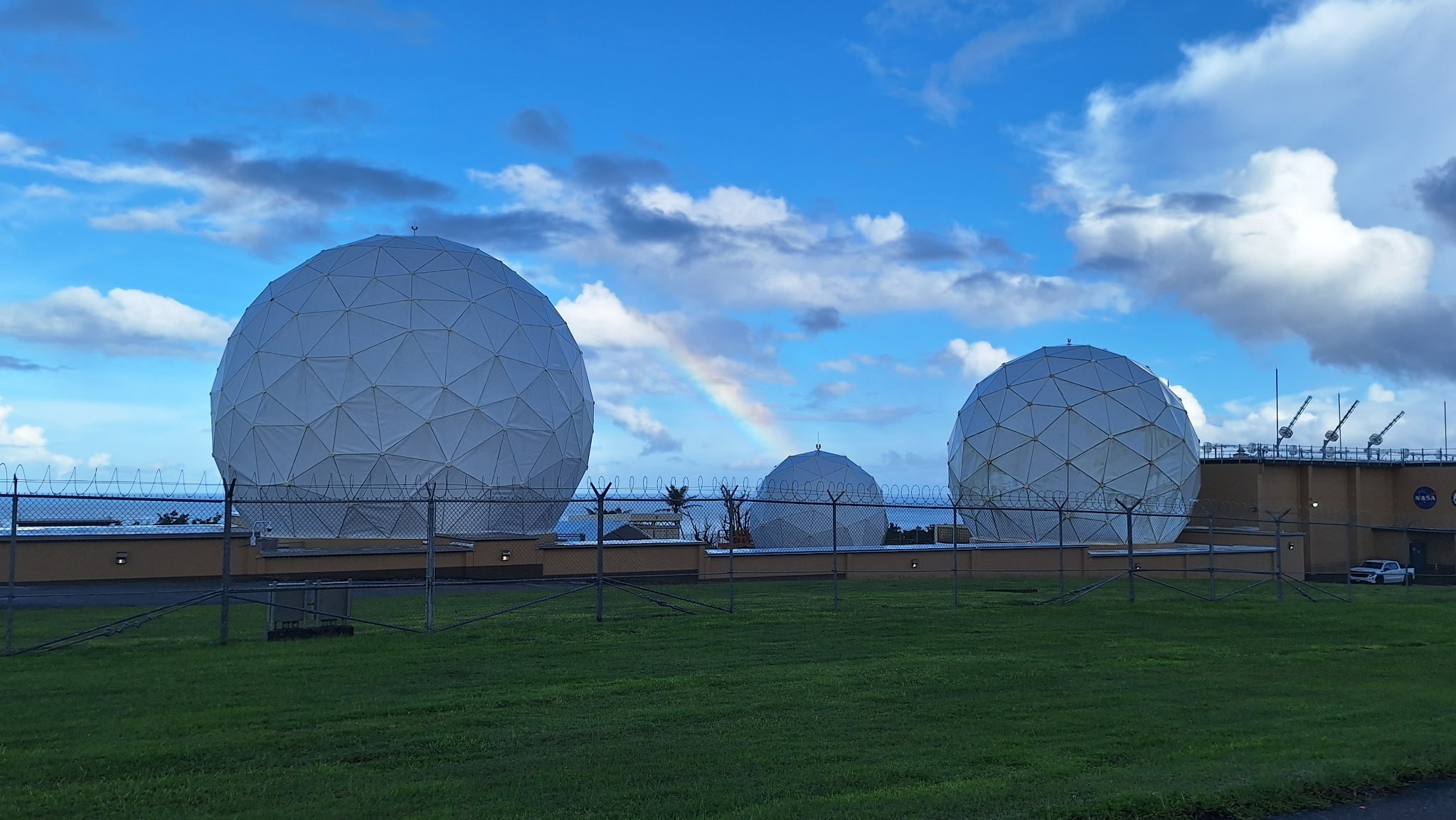
A rainbow arcs over the newly repaired Guam Remote Station antennas.
NASA
For nearly three decades, the Guam Remote Station has been one of three ground stations supporting NASA’s Tracking and Data Relay Satellites, or TDRS, a critical part of the Near Space Network. From 22,000 miles above Earth, the relays link spacecraft in low Earth orbit with the ground, allowing flight controllers to communicate with astronauts, command spacecraft, and receive mission data. The Guam station alone closes the “Zone of Exclusion,” a stretch of orbit beyond the relays’ line of sight. Without it, the International Space Station can lose contact with Earth for up to 20 minutes of every 90-minute orbit, an unacceptable risk for crewed missions.
On May 24, 2023, the Category 4 super typhoon struck Guam with 185 mph winds and more than 28 inches of rain, destroying two 16.5-meter antennas and damaging an 11-meter north antenna and the Inter Facility Link building at NASA’s station. The Zone of Exclusion reopened for the first time since 1998, cutting TDRS coverage to about 85% of a spacecraft’s orbit.
NASA made emergency repairs to the least-damaged antenna and borrowed two mobile terminals from the U.S. Army to expand coverage. The patchwork restored partial service within months, in time for a November 2023 spacewalk.
In early 2025, Congress dedicated disaster-relief funding to rebuild the ground station and harden the network against future storms. Construction began that summer and finished in summer 2026, when the rebuilt central antenna rejoined TDRS operations and the Zone of Exclusion closed once more. The same appropriation funded critical upgrades at three additional Near Space Network ground stations.
The return to service of the Guam Remote Station’s central antenna represents far more than the restoration of a critical piece of infrastructure — it is a testament to the dedication, resilience, and ingenuity of the people who made it possible.
Jena Garrahy
SCaN Deputy Program Manager for Network Operations
At the ribbon-cutting, representatives from NASA’s SCaN (Space Communications and Navigation) Division joined the station’s workforce and local leaders to mark the central antenna’s return to service. The Guam team, which led debris removal, site security, and on-island recovery, was recognized for its work to keep NASA connected to its missions through the outage and rebuild. A companion ceremony at NASA’s White Sands Complex in Las Cruces, New Mexico, honored the engineers and specialists across SCaN who supported the recovery off island.
“The return to service of the Guam Remote Station’s central antenna represents far more than the restoration of a critical piece of infrastructure — it is a testament to the dedication, resilience, and ingenuity of the people who made it possible,” said Jena Garrahy, Deputy Program Manager for Network Operations. “Through long days, challenging conditions, and unexpected obstacles, this team remained focused on the missions that depend on these critical assets every day.”
The Near Space Network is funded by SCaN, a division of NASA’s Research and Technology Mission Directorate, at the agency’s Headquarters in Washington. The network is operated out of NASA’s Goddard Space Flight Center in Greenbelt, Maryland. Repairs of the Guam Remote Station were managed out of NASA’s Glenn Research Center in Cleveland.
About the Author
Korine Powers
Lead Writer and Communications Strategist
Korine Powers, Ph.D. is a writer for NASA's SCaN (Space Communications and Navigation) Program office and covers emerging technologies, commercialization efforts, exploration activities, and more.
Preparations for Next Moonwalk Simulations Underway (and Underwater)
Water sloshing between the land and oceans shifts Earth’s center of mass relative to its geometric center. NASA scientists have developed a new technique using ultraprecise satellite tracking to estimate the displacement to within fractions of inches.
NASA’s Scientific Visualization Studio
Seasonal changes redistribute enough water around Earth to shift the planet’s center of mass back and forth by fractions of an inch relative to its geometric center. NASA scientists are on the case, tracking the oscillations because Earth’s center of mass is a crucial reference point for satellite navigation and elevation measurements.
A team, led by NASA’s Jet Propulsion Laboratory in Southern California, has proposed a way to calculate the seasonal swings with extreme precision. The technique and findings are detailed in a new study published in Geophysical Journal International. The authors paint a vivid picture of springtime thaws, churning oceans, and dense winter air shifting massive surface loads from season to season.
The study isn’t the first attempt to pin down Earth’s center of mass. Scientists over the decades have pioneered several space-based techniques to define and locate it. But it’s a moving goalpost. If Earth were a hard blue marble, its center of mass would simply overlap its geometric center. In reality, the planet is sloshing and sagging under the weight of water, ice, and air. Because of this, Earth’s center of mass continually swivels around its geometric center by as much as several millimeters.
NASA’s Space Geodesy Project currently uses a variety of space- and land-based techniques to track Earth’s center of mass (also called the geocenter) moving up and down and side to side. This animation traces the millimeter-scale motion from 1993 to 2017.
NASA’s Scientific Visualization Studio
How accurate are existing methods to measure the size of the swivel? The last two international estimates, made in 2017 and 2023, differ by 0.27 inches (7 millimeters), about the height of three stacked nickels. The difference is almost as large as the motion itself.
To reduce uncertainty, JPL geoscientist Donald Argus led the development of a new technique based on ultraprecise satellite tracking.
Driven by gravity, satellites naturally orbit Earth’s center of mass, as if bound by invisible tethers. Tiny changes in the distance between satellites and ground stations reflect Earth’s shifting center of mass.
Using satellites to locate Earth’s center of mass is not a new idea. In fact, dense metal satellites, launched in 1976 and 1992, are dedicated exclusively to this purpose. Resembling 900-pound (408-kilogram) disco balls, both Laser Geodynamics Satellites (LAGEOS 1 and 2) are studded with reflective prisms and tracked with laser precision via ground stations globally distributed across more than 20 countries.
However, one limitation of satellite laser ranging is the uneven distribution of ground stations around Earth. The new technique improves accuracy in two ways: It adds GPS tracking into the mix along with orbital data from several satellites in low Earth orbit to provide a diverse array of targets. And it considers how the weight of water and ice deforms Earth’s crust, taking ground stations along for the ride.
The technique was developed by Argus along with researchers from JPL’s satellite orbit determination team, the University of Nevada, University of Montana, and the Helmholtz Centre for Geosciences in Germany.
“We’re now estimating the size of the movement of Earth’s mass center back and forth each year to be about half of what we believed it to be eight years ago,” said Argus. “Our findings suggest that the mass of Earth’s water and air moving between the hemisphere is smaller than previously thought.”
Felix Landerer, one of the study’s coauthors at JPL, noted that “while these movements might appear tiny, our modern world relies on extremely accurate positioning measurements. By unraveling and understanding the mechanisms that change reference systems, we can build better reference systems that ultimately benefit mapping and navigation — from global shipping logistics to precision agriculture.”
What they found
The study authors tracked Earth’s center of mass oscillating seasonally and attributed the cause to three categories: oceans, atmosphere, and continental water (made up of land ice, snow, lake and river water, soil moisture, and groundwater).
They found that snow accumulation in North America and Eurasia reaches a maximum in March and shifts Earth’s center of mass about 3 millimeters toward the North Pole. A month later, in April, rainwater in the Amazon River basin peaks at 2,400 gigatons, swinging Earth’s center of mass 2.2 millimeters toward South America. Monsoon water in southeast Asia attains a maximum of 600 gigatons six months later in November, adding slightly to the annual oscillation.
Between August and October, the oceans swell with meltwater and rain, and Earth’s center of mass shifts toward the South Pacific Ocean. The Pacific Ocean is so large that mass changes there overshadow the loss or gain in other oceans, though seasonal dynamics in the Mediterranean, Red, North, Baltic, and Barents seas all help shift Earth’s center of mass in their own small way.
The researchers used a model developed by the European Centre for Medium-Range Weather Forecasts to estimate how atmospheric changes affect Earth’s center of mass throughout the seasons. They found that cold, dense, winter air helps tip the scales over Arabia, Asia, and northern Africa around Dec. 21 each year, and over South America and South Africa around June 21.
The mass calculations in the study are consistent with observations made by the Gravity Recovery and Climate Experiment Follow-On (GRACE-FO) mission. Launched in 2018, the mission is made up of twin satellites that map monthly fluctuations in Earth’s gravitational pull due primarily to the mass movement of water above and below ground. The two satellites fly in precise formation, and when the lead satellite passes over a dense body, like a swollen river basin, the extra gravitational tug changes the distance between its twin by a small but measurable amount.
The GRACE-FO mission is a joint partnership between NASA and the German Research Centre for Geosciences (GFZ). The next-generation GRACE-Continuity (GRACE-C) mission is targeting a launch in late 2028 to extend the nearly 25-year GRACE-series data record.
Anak Krakatau erupts ash and volcanic gases in this Sept. 5, 2026, image acquired with the OLI (Operational Land Imager) on Landsat 8. Eruptions are a regular occurrence at Anak Krakatau, a small volcano between the Indonesian islands of Java and Sumatra. Much of its activity remains relatively mild, but it occasionally puts on more impressive and hazardous shows of force. In early September 2026, a booming eruption lasting more than 24 hours sent gas and ash high into the atmosphere, disrupting thousands of flights and degrading air quality in parts of the country, including the capital city of Jakarta.
Curiosity Postcard Celebrates Rover’s 5,000th Day on Mars
PIA26700
Credits: NASA/JPL-Caltech
Downloads
Curiosity Postcard Celebrates Rover’s 5,000th Day on Mars
JPEG (459.76 KB)
Description
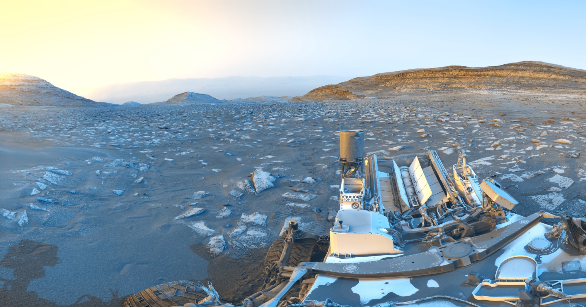
While parked at a sand ridge nicknamed “Chocolatal,” NASA’s Curiosity Mars rover used its black-and-white navigation cameras to capture panoramas at two times of day. The first was taken on Aug. 30, 2026, at 9:56 a.m. local Mars time; the second was taken on Sep. 2, 2026, at 5:39 p.m. local Mars time. Those dates correspond to the 5,000th and 5,003rd Martian days, or sols, of the mission.
After being sent back to Earth, the two images were merged together. Color was added for an artistic interpretation of the scene, with blue representing the morning panorama and yellow representing the afternoon one. The resulting “postcard” is similar to past examples created with rover images, such as one taken in November 2021.
The rover’s deck can be seen in the foreground, including its can-shaped UHF antenna, used for sending data to orbiting spacecraft, and its finned Multi-Mission Radioisotope Thermoelectric Generator (MMRTG), a nuclear power source, at its rear. The rover’s tracks can be seen trailing off in the distance.
Curiosity is in the lower foothills of Mount Sharp, a 3-mile-tall (5-kilometer-tall) mountain that sits within Gale Crater. This image looks down toward the crater floor, with the crater rim barely perceptible on the horizon.
Curiosity was built by NASA’s Jet Propulsion Laboratory, which is managed by Caltech in Pasadena, California. JPL leads the mission on behalf of NASA’s Science Mission Directorate in Washington as part of NASA’s Mars Exploration Program portfolio.
NASA recently awarded $10.5 million to seven organizations nationwide through its new State Hubs initiative. Space Florida was selected for Project ORBIT, which aims to expand opportunities for middle and high school students, boost enrollment in key career and technical programs, and create a statewide portal connecting skilled workers with aerospace employers.
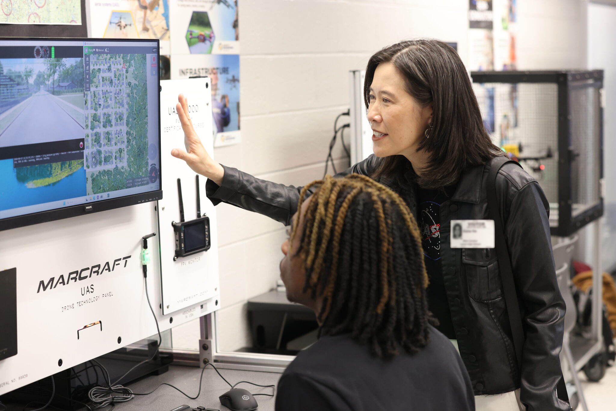
Elaine Ho, right, associate administrator for NASA’s Office of STEM Engagement, discusses training software with a student at Lyman High School in Longwood, Florida on on Aug. 27, 2026.
Credit: NASA/Clayton Rougelot
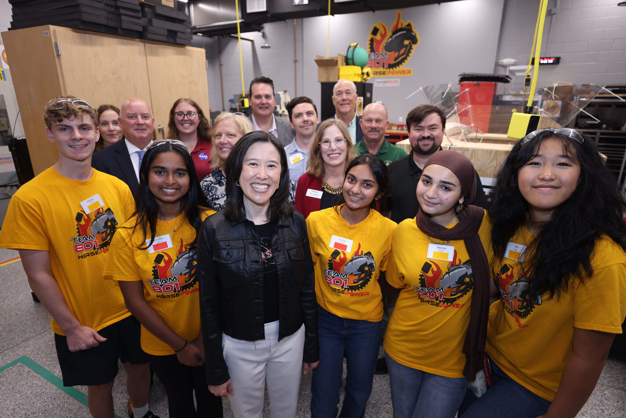
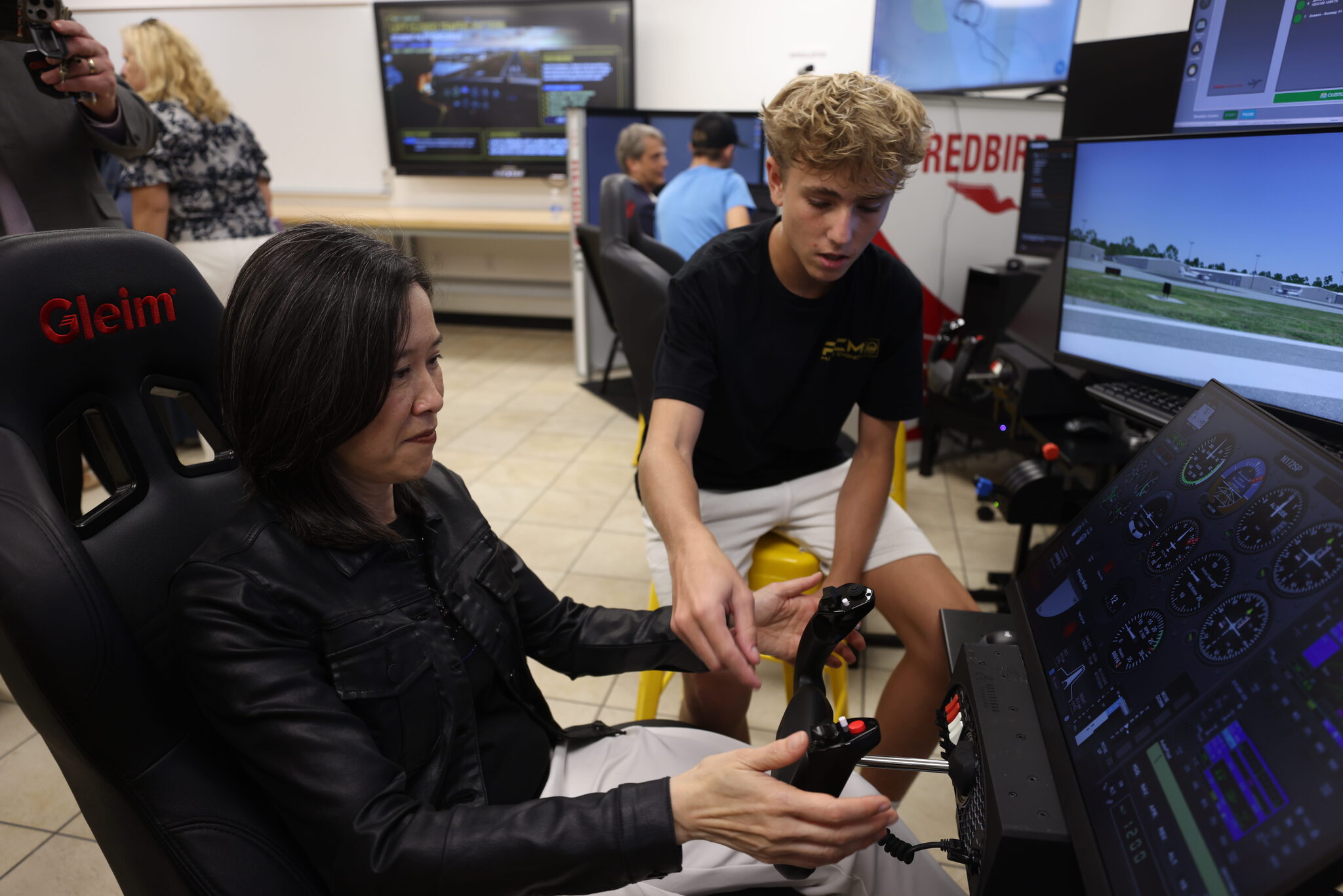
Elaine Ho, associate administrator for NASA’s Office of STEM Engagement, joined local leaders and industry partners recently to see Space Florida Academy students in action at three Central Florida schools. Students at Lyman High School in Longwood, Florida, demonstrated their skills in aerospace engineering, robotics, building trades, welding, and more. Later, in Merritt Island, Florida, Ho and the other leaders stopped by the Aeronautics & Flight Exploration (AFEX) program and cloud computing classrooms at Merritt Island High School and the robotics lab at nearby Edgewood Junior/Senior High School.
Since its launch in August 2024, the Space Florida Academy has expanded from 23 to 42 participating school districts, preparing students for careers in aviation and aerospace, advanced manufacturing, construction, cybersecurity, logistics, and semiconductors.
Elaine Ho, center, poses for a photo with Space Florida representatives, public school officials, aerospace industry partners, and students at Edgewood Junior/Senior High School in Merritt Island, Florida on Aug. 27, 2026.
Credit: NASA/Clayton Rougelot
“It’s all about showing students what’s possible and then giving them the tools to achieve it,” said Dean Cuke, Merritt Island High School AFEX astronautics and aviation flight instructor. “There are far more possible pathways to be part of the space industry than I think they realize. We’re showing them ways that they can attain that, through learning, through motivation and chasing after their dreams. I’m excited for them.”
Merritt Island High School juniors and student pilots Olivia Street and Troy Wallenburg have both benefited from the program.
“It makes you feel like you’re a part of something way bigger than just a high school class. I learned what I want to do when I grow up – to be a pilot,” Street said.
“My entire life, I’ve just loved space,” Wallenburg said. “It’s great knowing that I’m actually somewhat involved in it, too.”
A student in the Merritt Island High School Aeronautics and Flight Exploration program shows Elaine Ho, left, how to use a flight simulator on Aug. 27, 2026.
Credit: NASA/Clayton Rougelot
“I’m so impressed by how this region holds so many opportunities for our students, who are incredibly capable of solving hard problems, who can build our hardware, who want to be part of something bigger than themselves,” Ho said. “NASA is really focused on ensuring that those opportunities are easier to reach.”
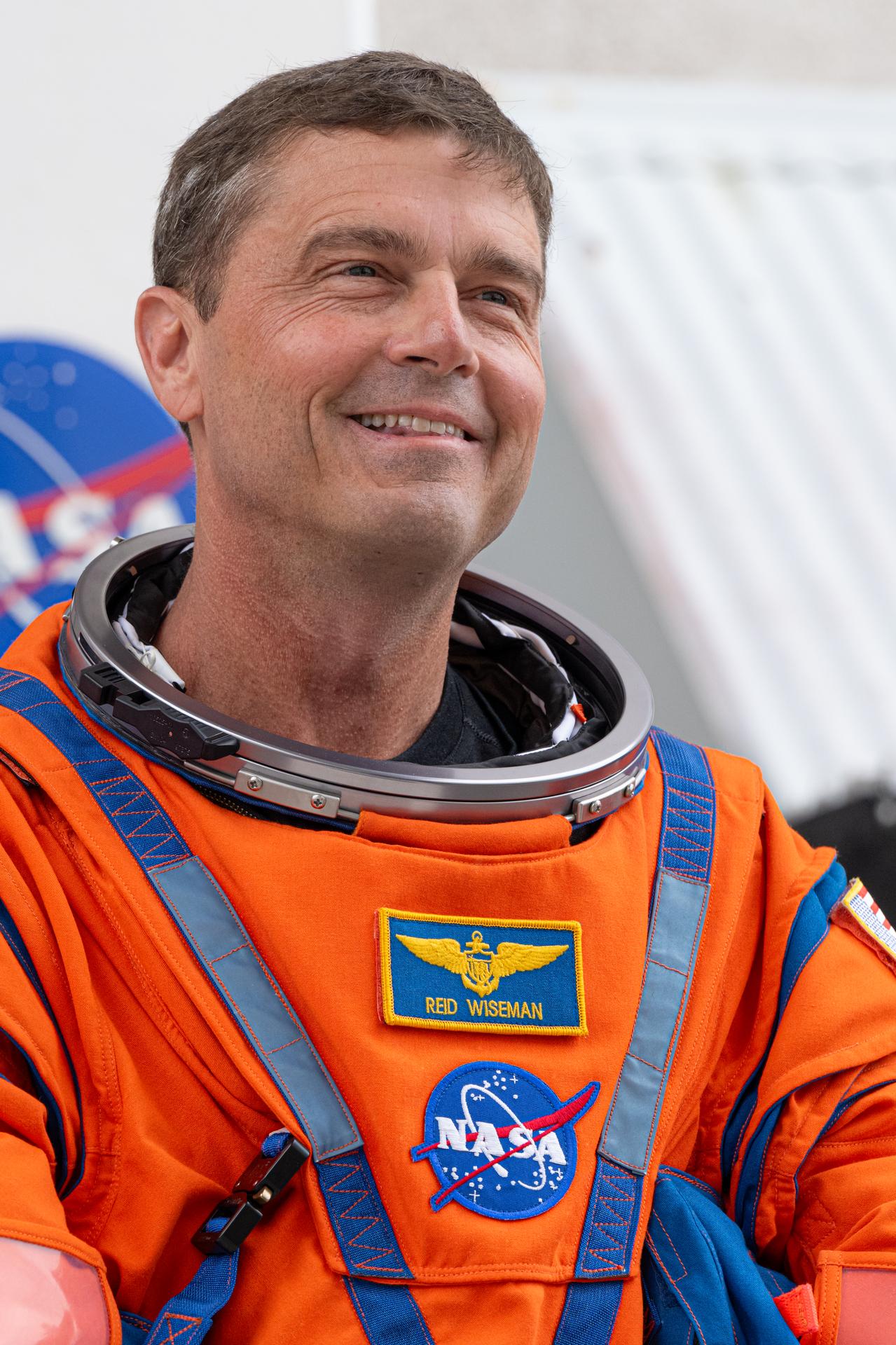
NASA astronaut Reid Wiseman prepares to depart the Neil A. Armstrong Operations and Checkout Building for Launch Complex 39B at the agency’s Kennedy Space Center in Florida to board NASA’s Artemis II SLS (Space Launch System) rocket and Orion spacecraft for the agency’s Artemis II launch on April 1, 2026.
Credit: NASA/John Kraus
As part of NASA’s new Inspiration Tour, Reid Wiseman, NASA astronaut and commander of the agency’s Artemis II mission, will highlight America’s strengths in space exploration and aeronautics innovation at the Baltimore Ravens vs. New Orleans Saints game in Baltimore on Sunday, Sept. 20.
A Baltimore native, Wiseman is a 27-year Navy veteran and NASA astronaut who spent 175 days in space over two missions. On April 1, Wiseman launched from NASA’s Kennedy Space Center in Florida on a SLS (Space Launch System) rocket as part of the Artemis II mission. Wiseman and his fellow Artemis II crew members completed a historic lunar flyby, marking humanity’s return to the vicinity of the Moon for the first time in more than 50 years.
Wiseman also will be available for media interviews inside the stadium at 12:20 p.m. To RSVP for the media availability, please contact Shaneequa Vereen at: shaneequa.y.vereen@nasa.gov.
NASA team members will engage with fans at the agency’s Experience Zone, located outside the stadium from 10 a.m. to 1 p.m. before the game. Fans can learn more about NASA’s return to the Moon through the agency’s Artemis program, enjoy interactive games, and capture photos at a selfie station and with a large, inflatable NASA logo.
With stops across the nation, NASA’s Inspiration Tour convenes academic, industry, and public sector stakeholders to connect the agency with the people, technologies, and organizations that drive American leadership in space.
The tour will culminate in MAX POWER, a public exposition of American air and space innovation, Saturday, Nov. 7, and Sunday, Nov. 8, on and near the agency’s Kennedy Space Center in Florida. Held in honor of America’s historic 250th anniversary, the multi-day, family-friendly event will showcase the next-generation aircraft, spacecraft, autonomous vehicles, and technologies that will help define the future of transportation in air and space.
For more information about MAX POWER and the agency’s missions, visit:
Discover the cosmos! Each day a different image or photograph of our fascinating universe is featured, along with a brief explanation written by a professional astronomer.
Webb’s View of M64
Explanation: Sometimes where Hubble finds darkness, Webb sees light. An example is today’s composite images of Messier 64 (M64), a nearby spiral galaxyof many names. The dark band of dust partially blocking its bright core earned it the moniker “the Black Eye Galaxy.” Webb’s Mid-InfraRed Instrument (MIRI) sees that dust, shown in red, as it absorbs and re-emits light from surrounding newborn stars. These young stars are embedded in pink star-forming regions in the Hubble-only image. M64’s inner and outer gas regions counter-rotate, creating regions of increased star formation where the two gas “currents” meet and compress. A merger between M64 and a smaller galaxy was likely the cause of the opposing motion of the outer gas. Spiral galaxies were once thought to have peaceful histories. M64 was key evidence that spiral galaxies, including the Milky Way, can and do experience mergers. Webb’s view of M64 will tell astronomers about the structure, motion, and composition of the galaxy’s dust and add context to the galaxy’s merger history and evolution.
The NASA Ames Science Directorate recognizes the outstanding contributions of (pictured left to right) Steve Ormsby, Aphrodite Kostakis, Alejando Borlaff, Sarah Nickerson, Martina Caussi, Keiko Nomura, and Stephen Broccardo. Their commitment to the NASA mission represents the entrepreneurial spirit, technical expertise, and collaborative disposition needed to explore this world and beyond.
Space Biosciences Star: Steve Ormsby
Steve Ormsby is a project engineer for the Space Biosciences Division with Amentum in the Center Operations Directorate. He is recognized for his perseverance, dedication and initiative in overseeing the safety of division facilities and infrastructure maintenance, as well as exceptional diligence as a property custodian.
Space Biosciences Star: Aphrodite Kostakis
Aphrodite Kostakis is the Facility Service Manager with Amentum for building N239 in the Space Biosciences Division. She is acknowledged for her exemplary work ethic in maintaining building safety, preparing for and leading VPP inspections with diligence and attention, and suggesting infrastructure improvements and ensuring they get implemented for everyone’s benefit.
Astrophysics Star: Alejandro Borlaff
Alejandro (Alex) Borlaff, a research scientist in the Astrophysics Division with the Bay Area Environmental Research Institute, is recognized for his leadership in pioneering and developing image reduction pipelines for the Hubble Space Telescope (HST) and the Roman Space Telescope’s Wide Field Instrument (WFI). These algorithms significantly advance the detection of ultra-low surface brightness features through rigorous modeling of background contamination, including scattered and zodiacal light, better maximizing the science derived from NASA flagship astrophysics missions.
Astrophysics Star: Sarah Nickerson
Sarah Nickerson, a research scientist in the Astrophysics Division with the Bay Area Environmental Research Institute, is recognized for exceptional work on the analysis and curation of data taken from the EXES instrument on NASA’s Stratospheric Observatory for Infrared Astronomy (SOFIA) observatory. This provides high-level data products to the global astrophysics community for continued discovery and synergy with other NASA missions.
Planetary Science and Exobiology Star: Martina Caussi
Martina Caussi is a NASA Postdoctoral Program Fellow in the Planetary Science and Exobiology Division. Martina is recognized for her outstanding work using finite element simulations to determine that topographic relaxation has played a significant role in shaping Tegid, an unusually shaped impact crater on Europa. This work represents valuable precursory science in anticipation of the Europa Clipper mission, which will refine our understanding of this ocean world.
Earth Science Star: Keiko Nomura
Keiko Nomura is a research scientist for the NASA Earth Exchange (NEX) in the Earth Science Division with the Bay Area Environmental Research Institute. She is acknowledged for timely efforts in leadership, stakeholder engagement, coordination with NASA HQ management, and team building for the recently funded NEX-GeoAI project. This project is now being recognized as a key step forward to establishing NASA as the ground-truthing agency for federal and private sector GeoAI modeling activities for decision making.
Earth Science Star: Stephen Broccardo
Stephen Broccardo is a research scientist in the Earth Science Division with the Bay Area Environmental Research Institute. He is recognized for exceptional initiative and technical leadership in sustaining and advancing Ames’ atmospheric remote-sensing capabilities. Stephen has maintained critical observational capabilities and developed thoughtful technical milestones for future satellite-validation and science activities.
NASA will host an International Observe the Moon Night celebration from 5:30 to 8 p.m. CST on Saturday, Sept. 19, at the U.S. Space & Rocket Center, the official visitor center for NASA’s Marshall Space Flight Center in Huntsville, Alabama.
International Observe the Moon Night celebrates the Moon, the science behind it, and its connection to space exploration and human culture. NASA’s free public event will include agency experts delivering talks on lunar science and exploration and highlighting lunar observations made by the Artemis II crew in April.
Media interested in covering the event should confirm their attendance with Joel Wallace, joel.w.wallace@nasa.gov, in the NASA Marshall newsroom by 3 p.m., Friday, Sept. 18. Media must report to the Davidson Center to participate in the event. Visitor parking is available at the U.S. Space & Rocket Center.
NASA will have opportunities for media to capture visuals and interview agency experts. Activities available for coverage include hands-on STEM activities, a science stage show, an event photo booth, and face-painting.
The event also features Janet Ivey, the host of the television children’s series, “Janet’s Planet.” The Von Braun Astronomical Society will be on-site with telescopes, providing attendees with guided tours of the Moon, planets, and other celestial objects.
The evening is presented by the Planetary Missions Program Office at NASA Marshall.
For more information about International Observe the Moon Night, visit:
In April, the world watched as four humans circled the Moon for the first time in over 50 years with NASA’s Artemis II mission. On Saturday, Sept. 19, the public is invited to look up again with NASA events across the country, including the International Observe the Moon Night celebration held at NASA’s Goddard Space Flight Center Visitor Center in Greenbelt, Maryland.
This year, NASA will celebrate International Observe the Moon Night with people around the world on Sept. 19.
NASA/Vi Nguyen
International Observe the Moon Night is an annual celebration that brings people together to learn about the Moon and explore our connection to Earth’s nearest celestial neighbor. Since the program began in 2010, people around the world have participated through lunar observations, hands-on activities, artwork, music, and more.
At NASA Goddard, this year’s celebration will highlight the agency’s ongoing exploration of the Moon, including the historic Artemis II mission. Visitors can peer behind the scenes to learn more about what it took to make Artemis II’s journey around the Moon a success and discover how Goddard scientists and engineers are helping advance our understanding of the Moon, solar system, and beyond.
The event will run from 6 p.m. to 9 p.m. EDT.
Throughout the event at NASA Goddard, visitors can take part in interactive hands-on activities, create artwork and crafts, and capture selfies at a photo kiosk. Telescopes will also be set up outside (depending on weather), giving attendees an opportunity to observe the Moon and other astronomical objects up close. Inside the Visitor Center, guests can even see a real Apollo 14 Moon rock on display.
At 6:30 p.m., Dr. Amanda Nahm, planetary scientist at NASA Headquarters, will explore the lunar science and Moon joy from Artemis II.
At 7:30 p.m., Ernie Wright, scientific visualizer at NASA Goddard, will offer a more technical look at how scientists use real data to create videos and visualizations of the Moon.
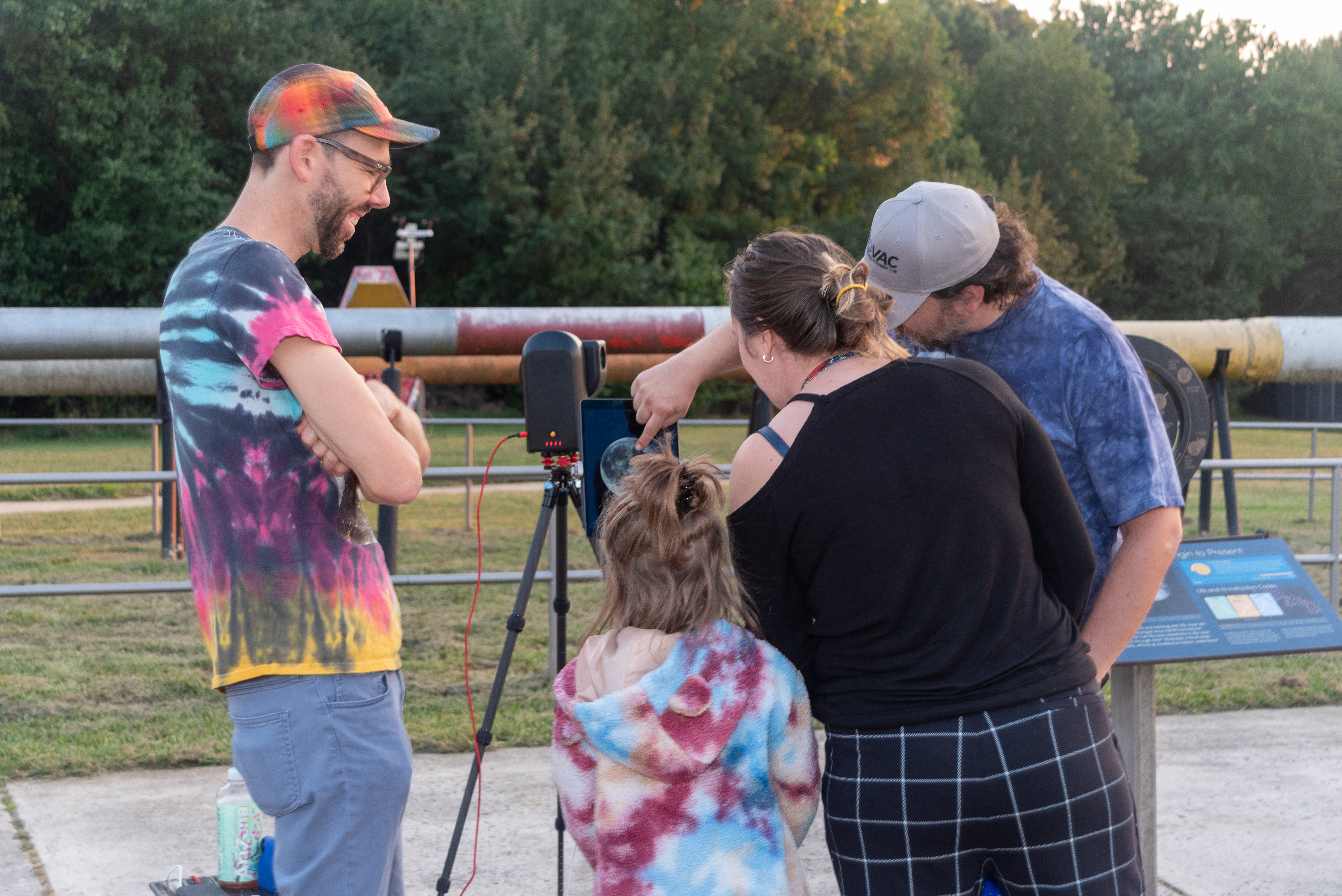
A family observes the Moon through a telescope at NASA’s Goddard Space Flight Center in Greenbelt, Md. during the International Observe the Moon Night celebration on Saturday, Sept. 14, 2024.
NASA/Britt Griswold
The event will also offer a chance to learn more about the groundbreaking research happening at NASA Goddard as scientists work to unlock the secrets of the Moon with missions like the Lunar Reconnaissance Orbiter (LRO) and explore our solar system and the universe beyond.
International Observe the Moon Night at Goddard is free and family friendly. Registration is not required, although registering in advance will help the Visitor Center team plan for the event. The event will take place rain or shine, and free parking is available at the Visitor Center.
For people who cannot travel to Greenbelt, there are opportunities to participate in International Observe the Moon Night from all around the planet. Join lunar observers around the world by observing the Moon with friends and family, attending a virtual event or finding an event in your area. Learn more and register your participation at go.nasa.gov/ObserveTheMoon.
International Observe the Moon Night is sponsored by NASA’s LRO mission and the Solar System Exploration Division of NASA’s Goddard Space Flight Center, with support from many partners. The celebration is a way for people to pause and look up at our future destination, as NASA prepares for deep space missions to the Moon and beyond.
NASA astronaut Randy Bresnik (left) and ESA (European Space Agency) astronaut Luca Parmitano view progress on the solid rocket booster integration in High Bay 3 inside the Vehicle Assembly Building at NASA’s Kennedy Space Center in Florida on Wednesday, Sept. 2, 2026.
Bresnik, Parmitano, and NASA astronauts Andre Douglas, Frank Rubio, and Bob Hines made the first visit to Kennedy by the entire crew and backup crew members of the Artemis III mission. Artemis III will launch four crew members aboard the Orion spacecraft to carry out a series of objectives in low Earth orbit designed to demonstrate critical systems needed for future lunar landings, beginning with Artemis IV.
The NSSC provides travel reimbursement services for all authorized Agency travel including: domestic, foreign, local, ETDY, and Change of Station (COS).
POV Mileage for NASA Travelers
For Privately Owned Vehicle (POV) Mileage Reimbursement Rates for TDY and ETDY Travel please refer to the GSA Web site: http://www.gsa.gov/mileage
NASA Domestic Travel: Day that Travel Ends
For the day travel ends (the day a traveler returns to the PDS, home, or other authorized point), the per diem allowance is 75% of M&IE.
NASA Domestic Travel Rental Car Liability
When making a reservation for a rental car, please remember the Government is only responsible to pay for rental car charges for official travel time. If a traveler decides to take annual leave in conjunction with official travel and keeps the rental car during annual leave, the portion of the rental rate applicable to annual leave is the responsibility of the traveler. Please refer to 41 CFR 301-10.453
What is my liability for unauthorized use of a rental automobile obtained with Government funds?
You are responsible for any additional cost resulting from the unauthorized use of a commercial rental automobile for other than official travel-related purposes.
NASA Domestic Travel: Tax Exemption
Prior to traveling, refer to the GSA State Tax Information webpage: https://smartpay.gsa.gov/smarttax. Select your State/US territory of interest to see the exemption status and download the appropriate form, if required.
Extended Temporary Duty (ETDY)
Reduced Per Diem rate
NASA’s standard reduced per diem rate for ETDY travel is 65 percent under the current policy as defined in the NASA Procedural Requirements (NPR) 9750.1-3.1.2.
a. Consistent with 41 CFR 301-11.200, an ETDY authorization can include reasonable further reductions from this standard rate or limitations on approved lodging for unique circumstances, to the extent it can be determined in advance that such will substantially lower costs without mission impact. For example, if lodging is obtained at 50 percent per diem, the ETDY authorization should be adjusted to authorize a lower rate.
b. The reduced rate of reimbursement begins on the first day of travel regardless of the mode of transportation, except as noted in 3.1.3. Allowances are covered by the reduced per diem rate; therefore, NASA will authorize the employee a per diem rate (up to 65 percent) to reasonably cover expenses for a one bedroom furnished apartment. For ETDY greater than 90 days, first consideration should be given to long-term lodging facilities. Long-term lodging facilities are available on the GSA schedule at http://www.gsa.gov. If a long-term facility is not selected, proper justification should be provided.
Find more about Allowable ETDY Expenses Included in Reduced Per Diem Rate, please see the following document:
GSA’s Schedule 48 is designed for lodging needs of 30 days or more. This program provides housing accommodations for temporary or permanent relocation. Typical facilities include apartment or condominium type properties that may be furnished with all the amenities of a regular home. The current list of vendors is available by clicking on the link above. Most of these properties will accommodate NASA Extended TDY travelers within the 65% reduce per diem rate and will allow use of the government charge card.
Foreign Travel
Please consult the Code of Federal Regulations (CFR), NPR 9710.1, and NPR 9750.1. Please call the NSSC Contact Center using this form for additional information.
Discover the cosmos! Each day a different image or photograph of our fascinating universe is featured, along with a brief explanation written by a professional astronomer.
A Daytime Eclipse: Moon Occults Venus
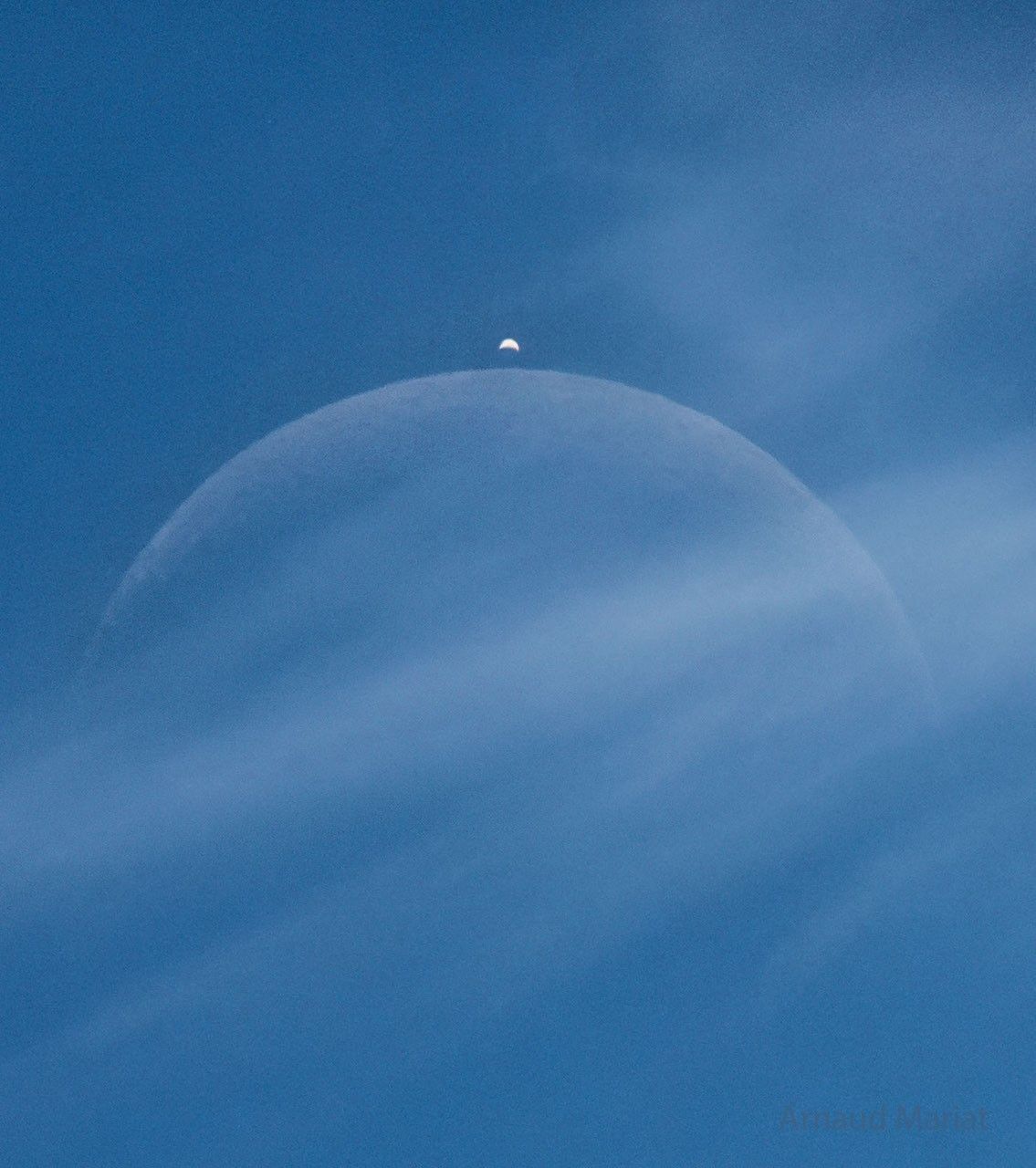
There was something behind the clouds. Upon close inspection, it was the Moon, which was hard to see yesterday around noon above the small village of Cessy, France. But soon, it was not only the Moon. As expected, a bright dot suddenly appeared from behind the Moon — the planet Venus far in the distance. Captured in the single featured exposure, both appeared to show a crescent phase. The Moon’s crescent was quite slight — with only about 10 percent of its face illuminated by the Sun. In contrast, Venus’s crescent was more full — showing about 25 percent illumination. Venus appeared brighter because it is nearer the Sun and because its clouds are more reflective than the dark lunar surface. An occultation of Venus by the Moon is visible to only about 10 percent of the Earth, but in yesterday’s event even most of that was experiencing daytime.
NASA’s Commercial Satellite Data Acquisition Program is a science‑enabling program that provides licensed access to high‑quality commercial Earth observation data, strengthens data quality through calibration/validation (cal/val) partnerships and transparent evaluations, and funds the development of science and application use cases to help turn commercial data into actionable research and applied solutions.
The program augments NASA’s gold standard fleet of freely and openly available Earth observing satellite observations and data products with high-resolution, high-frequency, and taskable commercial datasets.
During this webinar, speakers will provide an overview of the CSDA program’s activities and progress. Topics will include data modalities available through the program, updates to the evaluation process, the new cal/val initiative, and the status of existing task orders with CSDA data providers. In addition, presenters will cover the types of end-user licensing agreements, data availability and access, new data archive and tasking capabilities available through the Satellite Data Explorer, user engagement opportunities, and new learning resources.
NASA has selected 12 new investigations to help support human explorers in space. Six will help advance the ability to produce food off-planet, while another six advance the understanding of how unique conditions associated with space exploration can impact the health and physiology of astronauts.
The six food-focused investigations, supported by the agency’s Space Crops grants, advance NASA’s goal of harnessing the power of plants to enhance quality of life for humans in space, as well as to enable lunar and Mars exploration. Four of the space crops proposals focus on studies of edible plants and how their growth, physiology, and associated microbial communities are affected by environmental conditions in space or on other planetary bodies.
Another proposal involves understanding mechanisms by which certain plant species, called resurrection plants, can withstand extreme, dry conditions. The last space crops proposal builds on previous studies on the International Space Station to uncover functions of algal genes, segments of DNA controlling algae survival, whose expression is modified by spaceflight. Such studies can help scientists integrate biological-based solutions into space life-support systems.
The second set of six proposals fall under the agency’s Biological and Physical Sciences Division’s focus on precision health, which seeks to unravel the mechanisms by which space exploration affects health and well-being. One proposal studies how lunar dust exposure impacts respiratory, immune, and inflammation responses. A second proposal identifies repurposed drugs that can mitigate the effects space travel has on health and physiology.
Two more of the research proposals look at how radiation combined with other stressors affects age-relevant characteristics seen in various organ and physiological systems. The final two proposals assess molecular and cellular changes induced by stressors in space that can alter gene expression or protein function. The research will identify ways to mitigate health issues and develop early-warning detection systems to notify crew of potential concerns.
The principal investigators who conduct the space biology studies come from 10 institutions across eight states. Nine of the awards are for investigators who are receiving funding from the Space Biology Program for the first time.
Selected Space Crops Investigations
Jannell Bazurto, University of Minnesota Cultivating the Cosmos: Investigating Plant-Microbe Dynamics for Sustainable Space Farming
Miranda Haus, Michigan State University Investigating Legume Crop Rotations and Microbial Interactions in Regolith Simulants
Andrew Settles, NASA Ames Research Center Genetic Mitigation of Spaceflight Stressors on Production of Chlamydomonas
Christopher Taylor, Ohio State University Hydroponic Microbes in a Low Carbon, High-Radiation Environment; Identifying the Genetic Determinants of Water- and Plant-Associated Microbial Survival in Extraterrestrial Environments
Robert VanBuren, Michigan State University Leveraging the Natural Resilience of Resurrection Plants for Space Bioregenerative Systems
Shuyang Zhen, Texas A&M AgriLife Research Environmental Optimization and Cultivar Selection to Enhance Dwarf Tomato Growth and Stress Tolerance for Space Agriculture
Selected Precision Health Investigations
Archana Dhasarathy, University of North Dakota Epigenetic Memory as an Adaptive Mechanism to Microgravity and Radiation Exposure
Andrij Holian, University of Montana Contribution of Aging to Particle-Induced Chronic Inflammation
Mert Gur, University of Pittsburgh Probing Pathogenic Mutations Under Spaceflight-Relevant Stressors Via All-Atom Molecular Dynamics Simulations
Grace O’Connell, University of California Persistent Spine Health Impacts of Microgravity and Radiation Following Recovery
Satoshi Okawa, University of Pittsburgh Investigating Space Flight-Induced Brain-Heart Axis Aging and Identifying Repurposed Drugs to Mitigate Its Effects
Sanghee Yun, Ph.D., The Children’s Hospital of Philadelphia Spaceflight-Relevant Hypercapnia Effects on Space Radiation- and Social Isolation-Induced Biological Aging: A Systems Biology Analysis of Multiple Aging Hallmarks
When fully implemented, more than $7 million in grant money will be awarded throughout fiscal years 2026-2030. These awards were made in response to research proposals submitted to ROSES-2024: Program Element E.9: Space Biology Research Studies (NNH24ZDA001N-SBR).
NASA’s Biological and Physical Sciences Division pioneers scientific discovery and enables exploration by using space environments to conduct investigations not possible on Earth. Studying biological and physical phenomenon under extreme conditions allows researchers to advance the fundamental scientific knowledge required to go farther and stay longer in space, while also benefitting life on Earth.
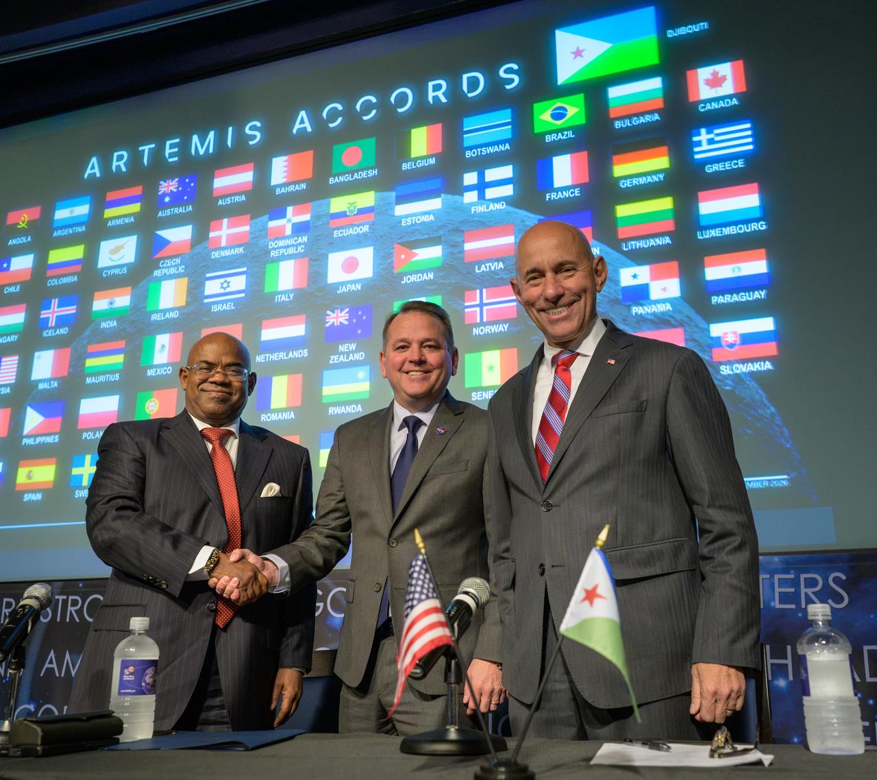
NASA Deputy Administrator Matt Anderson, center, Ambassador of Djibouti to the United States, Mohamed Siad Douale, left, and Assistant Secretary of State for African Affairs, Frank Garcia, right, pose for a group photograph after the Artemis Accord signing, Monday, September 14, 2026, at the Mary W. Jackson NASA Headquarters building in Washington.
NASA/Bill Ingalls
The Republic of Djibouti became the 72nd nation and eighth African country to sign the Artemis Accords during a ceremony Monday at NASA Headquarters in Washington. The Artemis Accords are the first set of practical principles aimed at enhancing transparency, safety, and coordination among nations as they explore the Moon, Mars, and beyond.
“Djibouti joins this coalition of like-minded nations at an important time,” said NASA Deputy Administrator Matt Anderson, who hosted the ceremony. “President Trump has directed NASA to return Americans to the lunar surface, establish an enduring presence, and lay the foundation for human exploration of Mars. NASA will lead, but we will not do it alone. We are creating opportunities for Artemis Accords nations to contribute hardware, scientific payloads, technology demonstrations, CubeSats, and other capabilities to future missions.”
Ambassador of Djibouti to the United States Mohamed Siad Douale signed on behalf of Djibouti. U.S. State Department Assistant Secretary for African Affairs Frank Garcia also participated in the event.
Djibouti’s national space program, launched in 2020 and managed by the Centre for Studies and Research of Djibouti within the Ministry of Higher Education and Research, has steadily expanded its technical capabilities. The nation successfully launched its first satellites, Djibouti 1A and Djibouti 1B, in 2023 and 2024, respectively. Both reached orbit aboard American Falcon 9 rockets launched from Vandenberg Space Force Base in California, an early example of how the U.S. is supporting Djibouti capabilities in space.
“By joining the Artemis Accords, Djibouti seeks to deepen its partnership with the United States and with the growing community of nations committed to peaceful space cooperation,” said Douale. “We look forward to building partnerships in scientific research, satellite applications, education, and technical training, while creating new opportunities for Djibouti students, researchers, engineers, and entrepreneurs.”
In 2020, NASA and the State Department joined with seven other founding nations to establish the Artemis Accords, responding to the growing interest in lunar activities by both governments and private companies, and committing nations to:
Explore peaceably and transparently
Render aid to those in need
Enable access to scientific data
Ensure activities do not interfere with those of others
Preserve historically significant sites and artifacts by developing best practices
By signing the Artemis Accords, nations open the door to opportunities for future lunar exploration with NASA, advancing humanity’s return to the Moon, and shaping the Golden Age of space exploration and innovation.

 Login