Discover the cosmos! Each day a different image or photograph of our fascinating universe is featured, along with a brief explanation written by a professional astronomer.
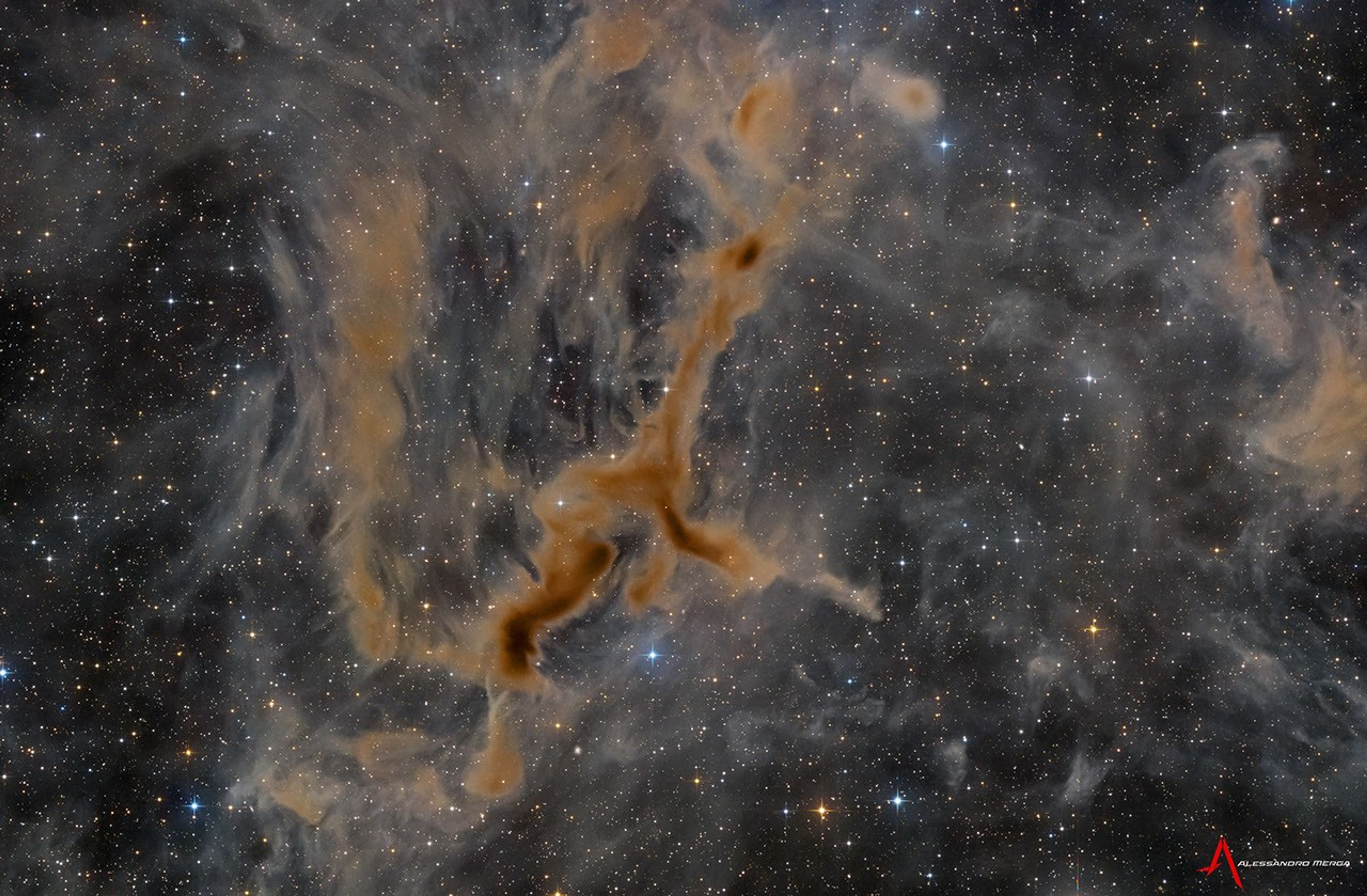
M83: The Southern Pinwheel
Explanation: Beautiful and bright spiral galaxy M83 lies some twelve million light-years away, near the southeastern tip of the very long constellation Hydra. Prominent spiral arms traced by dark dust lanes and blue star clusters lend this galaxy its popular name, the Southern Pinwheel. Still, reddish star forming regions that dot this cosmic pinwheel’s spiral arms have suggested another nickname, the Thousand-Ruby Galaxy. A mere 40,000 light-years across, smaller than the Milky Way, M83 is a member of a group of galaxies that includes active galaxy Centaurus A. In fact, the core of M83 itself is bright at x-ray energies, showing a high concentration of neutron stars and black holes left from an intense burst of star formation. This sharp, groundbased telescopic view also features foreground Milky Way stars and distant background galaxies.
The Republic of Djibouti will sign the Artemis Accords during a ceremony at 11 a.m. EDT, Monday, Sept. 14, at NASA Headquarters in Washington, becoming the 72nd country signatory.
NASA Deputy Administrator Matt Anderson will host Ambassador of Djibouti to the United States Mohamed Siad Douale for the ceremony, together with U.S. State Department Assistant Secretary for African Affairs Frank Garcia.
In 2020, during the first Trump Administration, the United States, led by NASA and the State Department, joined with seven other founding nations to establish the Artemis Accords, responding to the growing interest in lunar activities by both governments and private companies.
The accords introduced the first set of practical principles aimed at enhancing the safety, transparency, and coordination of civil space exploration on the Moon, Mars, and beyond.
President Donald Trump presents an executive order establishing the United States Space Academy during an event to award the Congressional Space Medal of Honor to the Artemis II crew as Michael Kratsios, director of the Office of Science and Technology Policy, left; Kevin Hassett, director of the National Economic Council, third from left; and NASA Administrator Jared Isaacman, right, applaud, Friday, Aug. 28, 2026, at NASA’s Johnson Space Center in Houston.
Credit: NASA/John Kraus
Less than two weeks after an Executive Order was signed to create the first United States Space Academy, NASA-led work is in full swing to make the academy a reality and shape the future of America’s aerospace workforce and leadership.
NASA Administrator Jared Isaacman chaired the first Presidential Commission on the United States Space Academy meeting on Sept. 9. Following that meeting, NASA published a Request for Information Thursday seeking input from governors or their designees interested in hosting and sponsoring the up-and-coming academy in their state.
“Our first Commission meeting made clear how much talent and commitment we have behind President Trump’s vision for the U.S. Space Academy,” said NASA Administrator Jared Isaacman. “I’m grateful to our partners across government for getting right to work. Now, with the RFI underway, states across the country have an opportunity to help us shape a legacy institution built for America’s future in space.”
Isaacman and Deputy Administrator Matt Anderson welcomed key commission members from multiple agencies and organizations to NASA Headquarters in Washington for a collaborative Commission discussion. Participants included U.S. Secretary of War Pete Hegseth, Director of the National Economic Council Kevin Hassett, Secretary of the United States Air Force Troy Meink, and U.S. Chief Technology Officer Ethan Klein, representing Director of Office and Technology Policy Michael Kratsios, along with representatives from the U.S. Office of Management and Budget, the National Security Council, and the White House.
During the meeting, commission members began working through the structure and priorities of the proposed U.S. Space Academy, including its governance, curriculum, service commitments, partnerships, and implementation.
“The location of the U.S. Space Academy is foundational to its success,” said Anderson. “We’re asking states to bring their strongest vision — the infrastructure, the partnerships, and the community that can compete with the elite options this caliber of student will have and match the boundless ambition of our future space leaders.”
The commission’s 120-day mandate to develop recommendations for President Trump on how to establish the academy and build the technical talent and leadership pipeline needed to support America’s long-term goals in space began when the President signed the Executive Order on Aug. 28.
Responses to the RFI will help inform the commission’s path forward to selecting a location for the institution and are due by 6 p.m. EDT on Monday, Oct. 26. An ambitious timeline is outlined in the request, calling for a groundbreaking no later than 2027, temporarily hosting the first 300 students in 2028, and a permanent location in operation by 2031.
Each state is allowed one submission to the Announcement via its governor’s designee. In addition to details about resources available to support the academy, input sought on the potential campus includes:
Location information
Site readiness
Environmental and regulatory considerations
Proximity and supporting ecosystems
A fact sheet on the U.S. Space Academy is available on The White House website.
NASA’s Life-Saving Technology Where Cell Signals Can’t Go
Rescued after more than four hours in the water, Easton Barrett (center, red shorts) and his friend were picked up by the U.S. Coast Guard thanks to a personal locator beacon (PLB). The devise sends a distress signal to satellites that are relayed back to Earth, launching a rescue operation.
Credits: Easton Barrett
Memorial Day weekend 2024 started with a blue sky and a mild three- to four-foot chop in the water off the Gulf Coast of Mississippi — a perfect day for a fishing competition. A team of five was about 40 miles offshore checking their sonar, and 30 seconds later the boat was gone. They were in the water struggling to pull on life jackets and grab the coolers as they bobbed up. When a boat sinks, survivors can be virtually invisible amid the vast expanse of water.
When their fishing trip went wrong, Easton Barrett had the only mobile phone and no cell service. He recorded a brief farewell, planning to put his phone in a cooler in hopes someone would find it.
Another team member activated a personal locator beacon (PLB) that had been stowed at the last minute, which sent a distress signal to the Search and Rescue Satellite-Aided Tracking (SARSAT) technology carried by multiple satellites in Earth orbit. In the SARSAT system, developed partly by NASA, an emergency signal containing the transmitter’s location is directed to the nearest available ground station.
406 megahertz is the wavelength dedicated for PLB distress signals. On the annual 406 Day, Easton Barrett posts videos and messages on his social media accounts to help raise awareness about essential survival gear.
Credit: ACR
A mission control center then alerts rescue coordination centers to mobilize search and rescue crews. For Barrett and his crew, that was a Florida Coast Guard boat.
“Ever since, I have tried to teach others about safety on the water and in the outdoors by using a PLB,” said Barrett. “If that will save one life, it’s worth the effort.”
A beacon like the one that saved his crew, a registered ResQLink PLB developed by ACR Electronics Inc. of Fort Lauderdale, Florida, also notifies the device owner’s emergency contact, indicating a distress call was activated. All emergency beacons must meet the same requirements to ensure they work when needed. Every rugged, buoyant, handheld devices have a five- to 10-year battery life.
SARSAT began operations in 1982, becoming an international collaboration in 1985. The flight and ground technologies used globally were originally developed at NASA’s Goddard Space Flight Center in Greenbelt, Maryland. Now there are 62 satellites in the program and 45 nations contributing services, from operating ground stations to providing rescue crews. More than 63,000 lives have been saved.
Turning on a ResQLink View PLB from ACR Electronics will automatically “ping” orbiting satellites that send location and GPS information
to the nearest search and rescue station. Whether on land or water, the appropriate resources will be dispatched to help anyone in distress
anywhere in the world.
Credit: ACR
SARSAT by the Numbers
The Search and Rescue Satellite-Aided Tracking system developed over several decades by NASA and other government agencies saves lives on land or at sea.
1982 — the start of U.S. operations
1985 — the start of international operations
62 operational satellites
45 nations contributing services
63,000+ lives saved
One rescue in 2024 demonstrates how it all comes together.
40 miles off the Mississippi Gulf Coast
5-person team participating in a fishing competition
30 seconds for a boat to sink
200 pounds of bait dumped to make a cooler buoyant
3 close encounters with wildlife, likely sharks and eels
4 hours in the water
1 personal locator beacon
1 Coast Guard rescue boat
5 lives saved
“If it has anything to do with NASA, it's got to be awesome.”
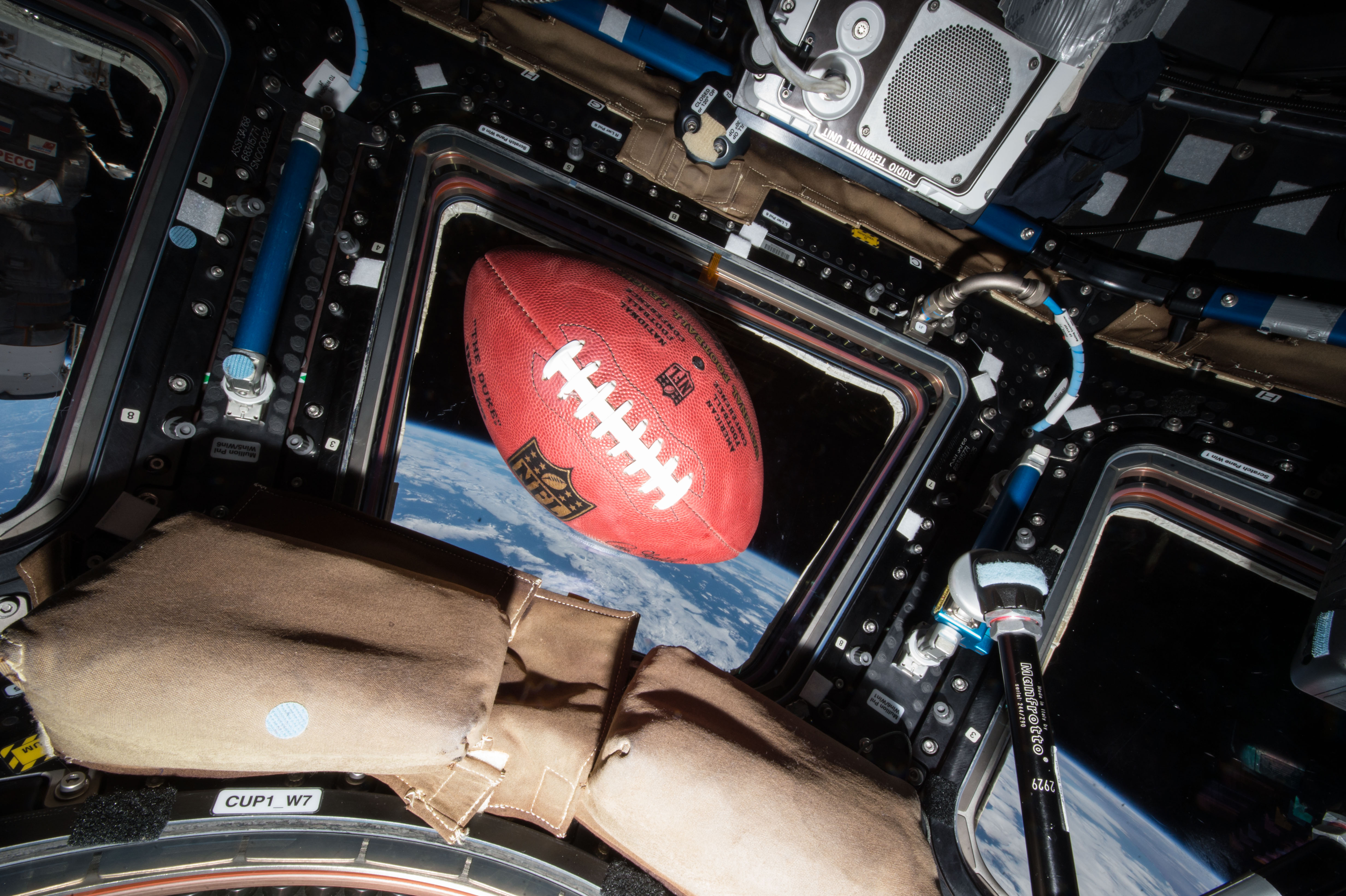
A football floats in microgravity aboard the International Space Station, high above the Earth.
Credit: NASA
Through a new collaboration between NASA and the National Football League (NFL), the agency will soon bring America’s strengths in space exploration and aeronautics innovation to the football field.
NASA will conduct flyovers, astronaut appearances, and fan engagement at NFL games across the United States as part of its new Inspiration Tour.
“This is the first season NASA is taking part in flyovers at NFL games, bringing the excitement of America’s space program directly to fans across the country,” said NASA Administrator Jared Isaacman. “We’re returning to the Moon, building a Moon Base, advancing fission-powered spacecraft, and pushing the boundaries in aeronautics, science, and discovery. Achieving those ambitions will take the very best of America, and partnering with the NFL gives us an incredible platform to inspire the next generation to look up and imagine the possibilities.”
NASA participation is targeted for the following games. Additional details will be released prior to each game, and more dates may be added:
1 p.m., Sunday, Sept. 13: Pittsburgh Steelers vs. Atlanta Falcons in Pittsburgh
1 p.m., Sunday, Sept. 20: Baltimore Ravens vs. New Orleans Saints in Baltimore
1 p.m., Sunday, Oct. 4: Philadelphia Eagles vs. Los Angeles Rams in Philadelphia
1 p.m., Sunday, Oct. 11: New York Jets vs. Cleveland Browns in East Rutherford, New Jersey
Flyovers scheduled at some of the games will showcase NASA’s fleet of aircraft, which are used for high-speed testing, high-altitude research, astronaut training, and more. Regularly flying the aircraft maintains the health of the fleet and publicly demonstrates new technologies that may be applied to future commercial air travel.
With stops across the nation and led by Isaacman, NASA’s Inspiration Tour convenes academic, industry, and public sector stakeholders to connect the agency with the people, technologies, and organizations that drive American leadership in space.
The tour will culminate in MAX POWER, a public exposition of American air and space innovation, Nov. 7 and Nov. 8, on and near the agency’s Kennedy Space Center in Florida. Held in honor of America’s historic 250th anniversary, the multi-day, family-friendly event will showcase the next-generation aircraft, spacecraft, autonomous vehicles, and technologies that will help define the future of transportation in air and space.
For more information about MAX POWER and the agency’s missions, visit:
ESA/Webb, NASA & CSA, F. Peißker, J. Lu, F. Yusef-Zadeh, N. B. Sabha, C. Chan
A brilliant concentration of stars takes center stage in this Aug. 11, 2026, image taken by NASA’s James Webb Space Telescope. Webb observed IRS 3, a star near the end of its life cycle, located within this starfield. Webb’s mid-infrared data revealed the clear signature of oxygen-rich silicate dust, as well as, for the first time, water, in its surrounding dust envelope.
Discover the cosmos! Each day a different image or photograph of our fascinating universe is featured, along with a brief explanation written by a professional astronomer.
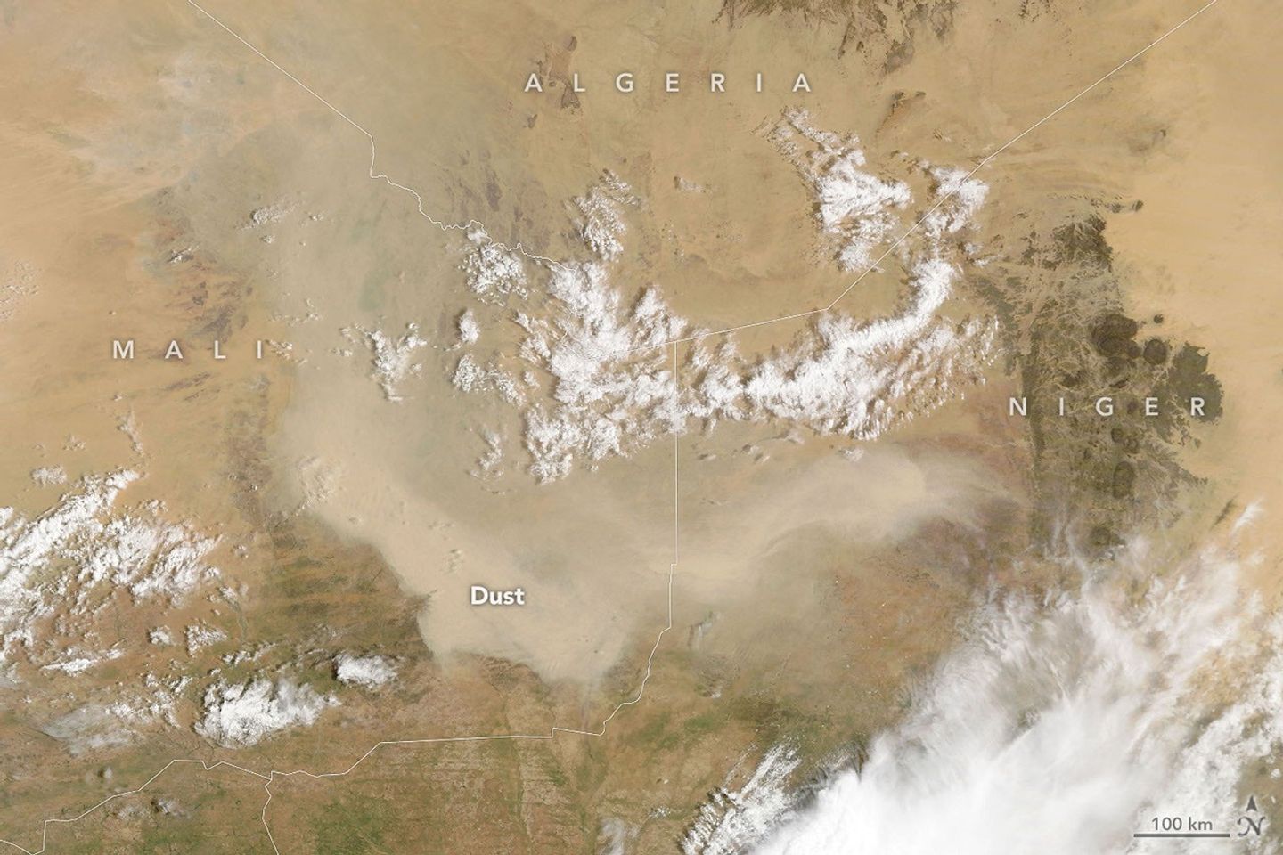
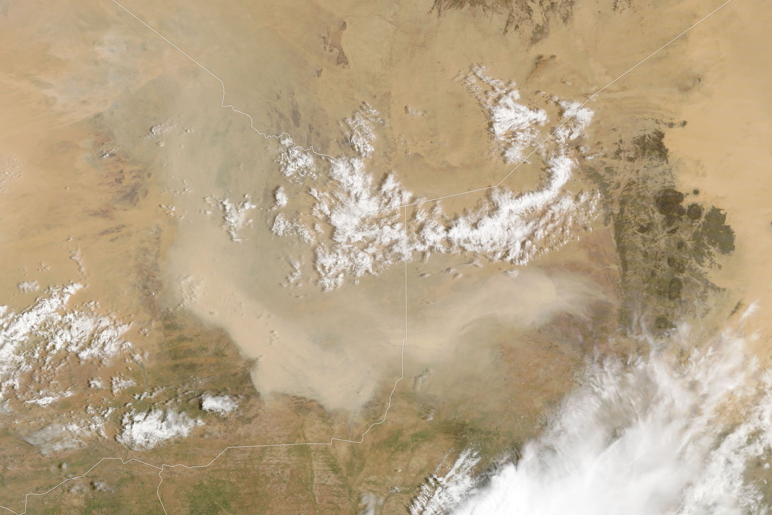
A dust storm obscures the ground in Mali in this image, acquired with the MODIS (Moderate Resolution Imaging Spectroradiometer) on NASA’s Terra satellite on September 5, 2026.
NASA Earth Observatory/Lauren Dauphin
As summer winds down in West Africa, so does much of the region’s dust activity. Dust storms can still occur, though, as one did in early September 2026, when a plume covered parts of Mali and neighboring countries.
The MODIS (Moderate Resolution Imaging Spectroradiometer) on NASA’s Terra satellite captured this image on September 5, 2026. According to Tianle Yuan, an atmospheric scientist at NASA’s Goddard Space Flight Center, storms like this one are often associated with haboobs—powerful dust storms driven by strong convective winds.
In the days after this image was acquired, a wider satellite view showed aerosols from the region moving westward and spilling over the Atlantic Ocean. However, a full transatlantic crossing is unlikely. Such crossings are more common from late spring through summer, when the Saharan Air Layer—a dry, dusty mass of air—can carry dust thousands of miles westward from Africa, riding high in the atmosphere.
Looking ahead, the developing El Niño could reshape these patterns. For instance, Yuan noted that the phenomenon can affect dust over the Sahel and Mali by shifting the Intertropical Convergence Zone and altering convection patterns, though the influence cuts both ways. Drier conditions can leave more loose sediment available for winds to lift, but less convective activity also means fewer intense storms (haboobs) to kick up large dust plumes in the first place. “The connection can be real,” Yuan said, “but hard to pin down for individual events.”
NASA Earth Observatory image by Lauren Dauphin, using MODIS data from NASA EOSDIS LANCE and GIBS/Worldview.Story by Kathryn Hansen.
A NASA Launch Services (NLS) II contract has been awarded by the agency to Relativity Space Inc., and its Terran R launch service in accordance with the contract’s on-ramp provision. The Terran R launch service will be available to NASA’s launch services to use for future missions.
The NLS II contracts are multiple-award, indefinite-delivery/indefinite-quantity contracts with an ordering period through June 2030 and an overall period of performance through December 2032. The NLS II contracts include an on-ramp provision that provides an opportunity annually for new launch service providers to compete for future missions and allows existing contractors to introduce launch vehicles not currently on their NLS II contracts.
The NLS II contracts support the goals and objectives of the agency’s Human Spaceflight Mission Directorate, Science Mission Directorate, and the Research and Technology Mission Directorate. Under the contract, NASA also can provide launch services to other government agencies, such as the National Oceanic and Atmospheric Administration.
NASA’s Launch Services Program Office at the agency’s Kennedy Space Center in Florida manages the NLS II contracts. For more information about NASA, visit:
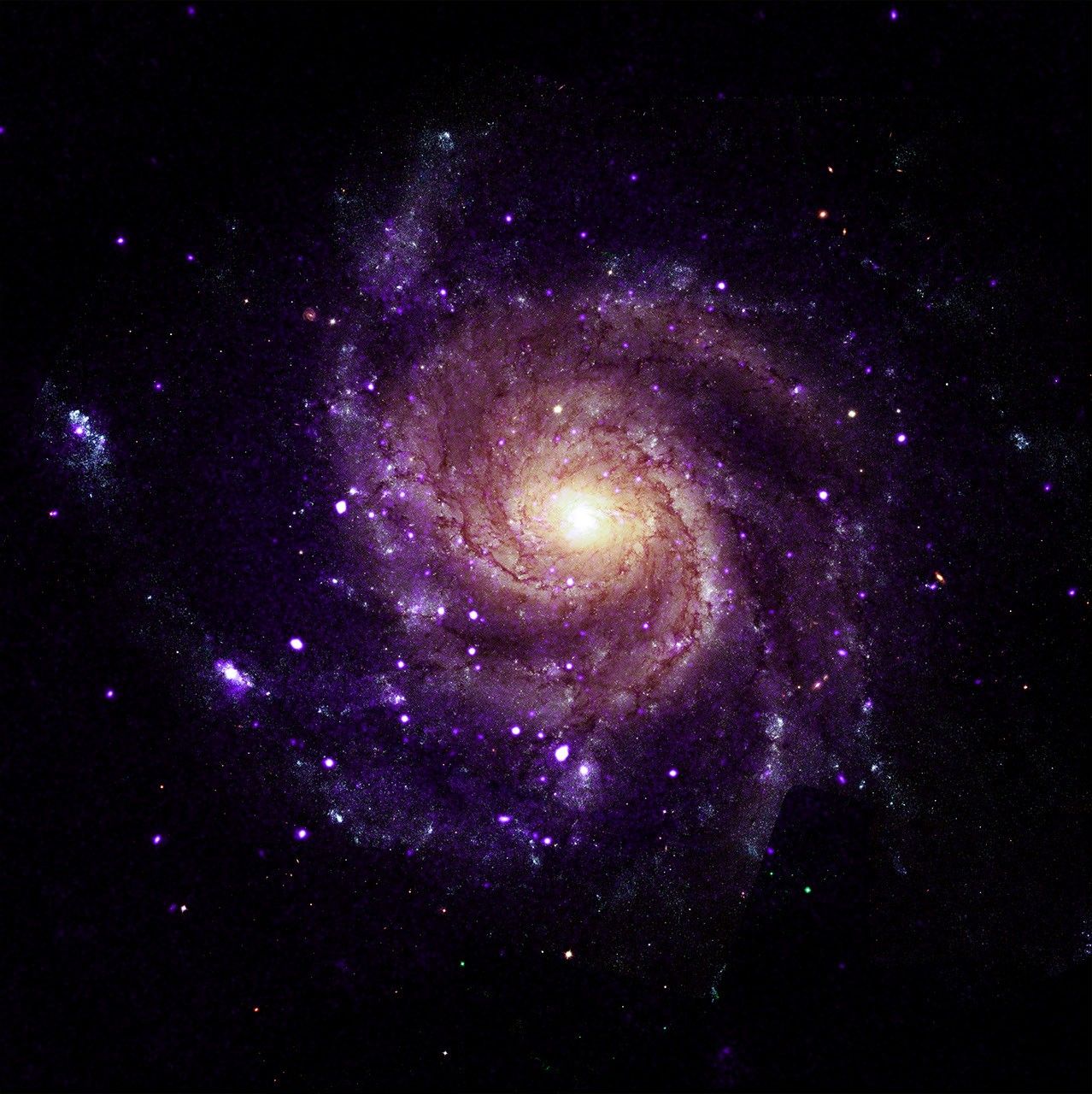
X-ray: NASA/CXC/Univ. of Alabama/M. Muhibullah et al.; Optical: NASA/ESA/STScI; Image Processing: NASA/CXC/SAO/N. Wolk
Using NASA’s Chandra X-ray Observatory, scientists have discovered a new class of objects behaving unlike any they have seen before. Astronomers suggest these newly spotted objects in other galaxies may help solve not one, but two long-standing questions in astrophysics.
These mysterious objects give off unusually low-energy X-rays but intense levels of ultraviolet radiation. This discovery is featured in a paper published Wednesday in Nature Astronomy.
“We’ve never encountered a group of objects that act like this,” said Mustafa Muhibullah of the University of Alabama who led the study. “Of course, the next step was to try to figure out what these things are.”
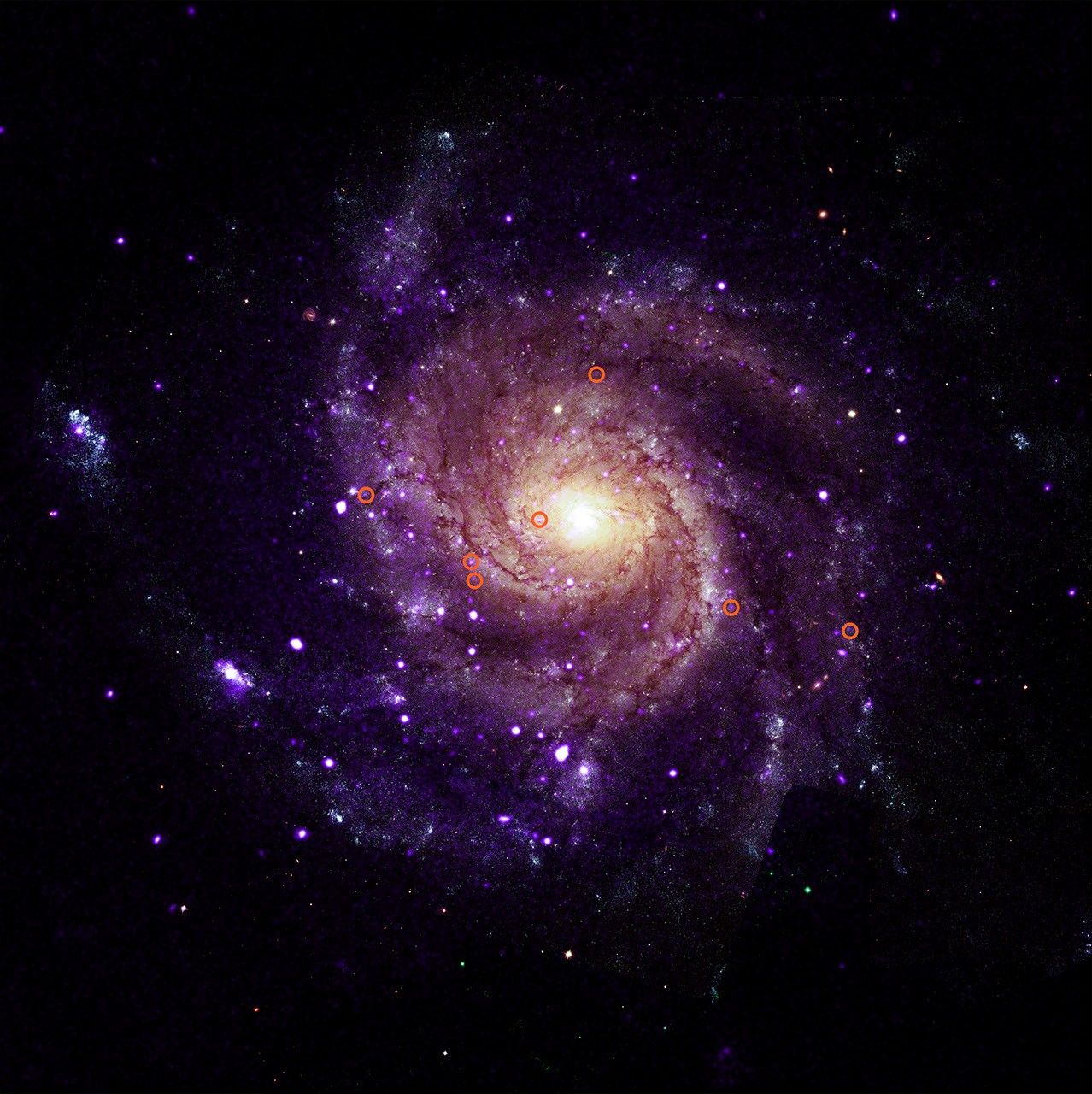
M101 with illustrated circles calling out seven of the newly-discovered objects.
X-ray: NASA/CXC/Univ. of Alabama/M. Muhibullah et al.; Optical: NASA/ESA/STScI; Image Processing: NASA/CXC/SAO/N. Wolk
The researchers found a total of 84 of these “hypersoft X-ray sources” – so named because they give such low-energy X-rays – in the six different galaxies they searched, using data openly available to the public in the Chandra archive. Two of the galaxies are spirals, M31 (the Andromeda galaxy) and M101 (the Pinwheel galaxy), while the other four are ellipticals. They found hypersoft X-ray sources both in regions of active star formation and areas where there are older stars.
The team spotted the sources by finding objects that appeared in Chandra images taken at the lowest X-ray energies but vanished in higher-energy images. That means these objects give off far more low-energy X-rays than high-energy ones. Because low-energy X-rays border energetic ultraviolet radiation on the electromagnetic spectrum, the researchers determined that these sources are producing large amounts of energetic ultraviolet radiation as well.
It is unclear what types of objects are responsible for these low-energy X-rays and intense ultraviolet radiation. The team thinks they most likely involve a black hole, neutron star, or white dwarf pulling material from a companion star. The material pulled from the companion star is heated up to produce X-rays before falling onto the white dwarf or neutron star, or into the black hole. Such binary systems have been seen before, but not with such bright ultraviolet radiation and low-energy X-rays.
The discovery suggests that there may be large populations of binary systems with energetic ultraviolet radiation that have been undetected until now.
“These clandestine X-ray sources are actually among the most energetic objects in galaxies, and they could be solving two cosmic mysteries at once,” said Muhibullah.
Scientists think that some white dwarf systems pulling material from companion stars may eventually explode as a supernova – known as a Type Ia – that is critical for measuring the expansion of the universe. These supernovae played a key role in discovering that this expansion is accelerating. Astronomers have been looking for the stars that turn into Type Ia supernovae for many years, so far without success.
“If we could find a way to spot these Type Ia supernova explosions before they go off, that would be really important,” said co-author Jimmy Irwin, also of the University of Alabama. “Right now, we study them after they’ve exploded, and astronomers have struggled to understand what is actually ignited.”
The other mystery these hypersoft X-ray sources might explain is what strips electrons from gas between the stars in some galaxies. This stripping of electrons is important to probe because it can affect how quickly stars form and influence the life cycles of galaxies. Hot, massive stars play a role, but they do not completely explain what is causing this stripping. The intense levels of ultraviolet radiation from the hypersoft X-ray sources may play a vital role.
Why were these hypersoft X-ray sources not found until now? In addition to the low-energy X-ray output, which is very difficult for X-ray telescopes to detect, the high-energy ultraviolet radiation is readily absorbed by helium and hydrogen gas that fills the space between the stars, creating a nearly impenetrable barrier to look through.
“By combing through the Chandra archive, we were able to eliminate what used to be a blind spot for telescopes,” said co-author Rosanne Di Stefano of the Center for Astrophysics | Harvard & Smithsonian. “That’s how we found what appears to be a new class of cosmic objects with remarkable qualities.”
NASA’s Marshall Space Flight Center in Huntsville, Alabama, manages the Chandra program. The Smithsonian Astrophysical Observatory’s Chandra X-ray Center controls science operations from Cambridge, Massachusetts, and flight operations from Burlington, Massachusetts.
This release features a composite image of a spiral galaxy, M101; one of six identified galaxies housing a new class of mysterious objects that give off unusually low-energy X-rays.
In this composite image, M101 faces us directly. It has multiple arms in shades of purple, spiraling clockwise around a golden yellow core. Scattered along and between the arms are scores of tiny specks in white and purple. Most of those specks are pairs of stars, but seven of them are a mystery.
To casual observers, the unusual objects are visually indistinguishable from the other specks of light in the galaxy. An annotated version of the composite image is included in this release, with red circles around the mysterious specks for easy identification.
These mystery specks behave like no other class of object discovered before. The curious objects give off X-rays of such low energy, they in fact produce large amounts of ultraviolet radiation, as UV radiation borders X-rays on the electromagnetic spectrum. Searching images of galaxies with low-energy X-rays in the Chandra Observatory archive, scientists have found a total of 84 such objects spread across M101 and five other galaxies. They have dubbed these mysterious objects “hypersoft X-ray sources.”
Preparations for Next Moonwalk Simulations Underway (and Underwater)
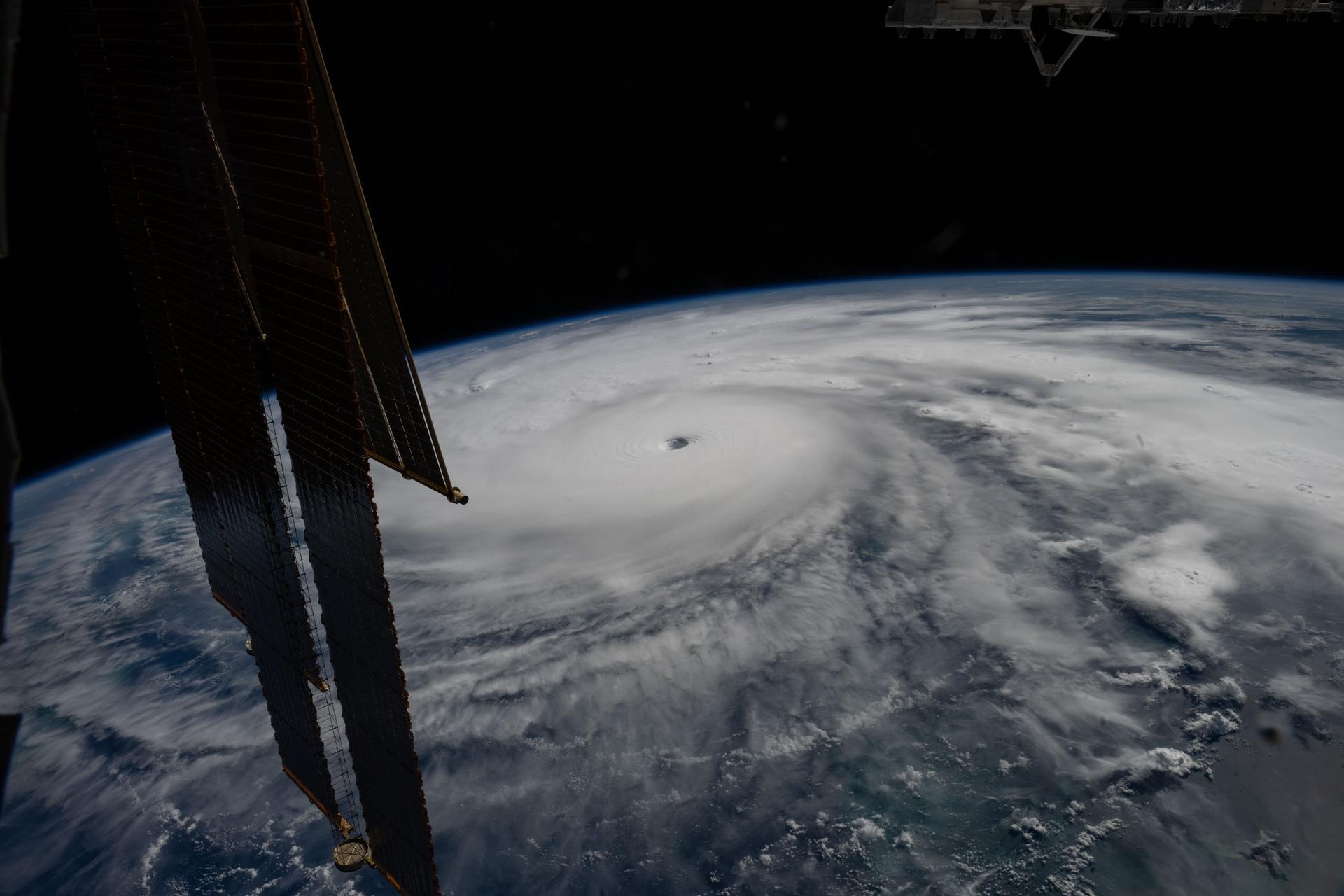
Hurricane Melissa is seen 50 miles south of Jamaica in this photograph taken from the International Space Station on Oct. 28, 2025.
NASA
Last November, NASA and its European partners launched the Sentinel-6B satellite to improve hurricane forecasts, help protect infrastructure, and benefit commercial industries, including shipping. The satellite now is flying 30 seconds behind its predecessor, Sentinel-6 Michael Freilich. Both satellites are providing precise sea level height measurements during what oceanographers expect to be a historic El Niño, a naturally occurring oceanic phenomenon in which warmer-than-usual Pacific waters shift global weather patterns.
The two satellites make up the Copernicus Sentinel-6/Jason-CS (Continuity of Service) mission, the latest in a series of ocean-observing radar altimetry missions that have been monitoring Earth’s changing seas continuously since the early 1990s.
The data each satellite is collecting will not only allow scientists to better understand this year’s El Niño but will also help them create more accurate hurricane predictions.
“This El Niño was a late-bloomer,” said Josh Willis, Sentinel-6B’s project scientist at NASA’s Jet Propulsion Laboratory in Southern California. “It didn’t kick off until the middle of the year and is just now reaching a strength similar to what we’ve seen in the satellite record during significant El Niños in 1997 and 2015. We expect it to be big, and it’s already having big impacts.”
El Niños generally scramble weather patterns tied to rainfall and storms, including hurricanes. They also redistribute heat in the ocean, which affects sea level. Normally, Earth’s warmest ocean waters sit along the equator in the western Pacific. During El Niño, weakened winds, which usually blow westward along the equator, result in heat spreading east toward South America. The change in ocean heat shifts hurricane activity from the Atlantic to the Pacific Ocean.
Predicting hurricane strength
On July 15, Sentinel-6B began delivering low-latency data to scientists that could be used for weather predictions. That data will take some time to work its way into the research models on which meteorologists and climate scientists rely, but when it does, those improved models could save lives.
Data from Sentinel-6 satellite missions feeds into hurricane tracking algorithms used by federal and state agencies. Those predictions can activate disaster response efforts, mobilizing resources ranging from sandbag placement to National Guard activation. They also can lead to evacuation orders that require quick but well-informed decisions about logistics at a local level. More severe events may require engaging larger organizations, such as the Federal Emergency Management Agency.
A tropical storm can take a week or more to become a hurricane and make its way to a coastline, but a hurricane can rapidly intensify in the 48 hours prior to landfall, leaving planners little time to prepare.
“Hurricanes have been known to speed up quickly at the last moment, so the window in which to decide what to do is short,” said Deirdre Byrne, an oceanographer and altimetry expert with the National Oceanic and Atmospheric Administration (NOAA). “The goal is to forecast how much and how rapidly intensification will happen so that officials can make the right calls.”
Each Sentinel-6 satellite measures ocean height, as well as the size of waves and marine wind speed, using a radar altimeter, which bounces thousands of radar pulses a second off the crests and troughs of waves. Ocean height varies from place to place and provides insight into the ocean’s heat content, since warm water expands. That, in turn, helps forecast how fast hurricanes will grow.
Among the measurements Sentinel-6 is gathering, Byrne is most anticipating the ocean height data, which she plans to begin incorporating into the current Satellite Ocean Heat Content Suite algorithm by the end of the year.
“In terms of data quality, the Sentinel-6 missions are unparalleled,” Byrne said.
Together, the missions are also extending a precise dataset deep into its fourth decade. This record of sea level observations traces back to the TOPEX/Poseidon mission, which launched in 1992, and continues through to the present day with Sentinel-6 Michael Freilich. Sentinel-6B will take over for its predecessor as the reference satellite for global sea level measurements later this year.
“The key is consistency, measuring the same way, every time,” said Severine Fournier, Sentinel-6B deputy project scientist, JPL. “That’s what lets us predict hurricanes, and, in turn, protect coastal communities and infrastructure.”
More about Sentinel-6B
Sentinel-6 Michael Freilich, named after a former director of NASA’s Earth Science Division, is one of two satellites that compose the Copernicus Sentinel-6/Jason-CS mission.
Sentinel-6/Jason-CS, a part of the European Union’s Earth observation program called Copernicus, was jointly developed by ESA (European Space Agency), EUMETSAT (European Organisation for the Exploitation of Meteorological Satellites), NASA, and NOAA, with funding support from the European Commission and technical support on performance from the French space agency CNES (Centre National d’Études Spatiales). Spacecraft monitoring and control, as well as the processing of all the altimeter science data, is carried out by EUMETSAT on behalf of the European Union’s Copernicus Programme, with the support of all partner agencies.
NASA JPL, a division of Caltech in Pasadena, contributed three science instruments for each Sentinel-6 satellite: the Advanced Microwave Radiometer, the GNSS-RO, and the Laser Retroreflector Array. NASA also contributed launch services, ground systems supporting operation of the agency’s science instruments, the science data processors for two of these instruments, and support for the United States members of the international Ocean Surface Topography Science Team.
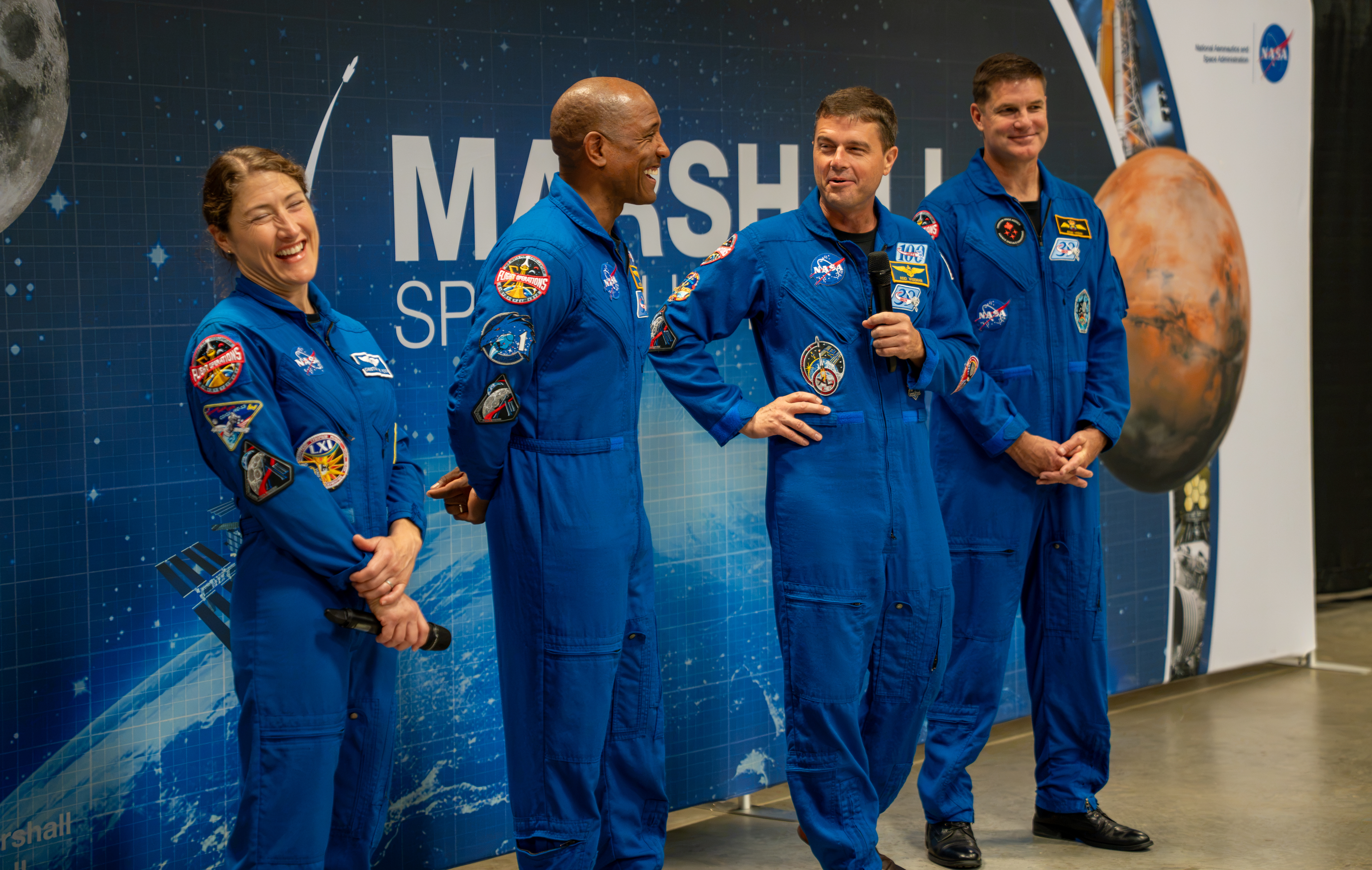
The crew of NASA’s Artemis II mission – NASA astronauts Christina Koch, Victor Glover, and Reid Wiseman and CSA (Canadian Space Agency) astronaut Jeremy Hansen – visited Huntsville, Alabama, Sept. 1, 2026, where they met with the NASA workforce at NASA’s Marshall Space Flight Center. The event gave the crew an opportunity to share firsthand experiences from their mission, reflect on their time in space, and connect with the workforce that supported the mission through an engaging question-and-answer session.
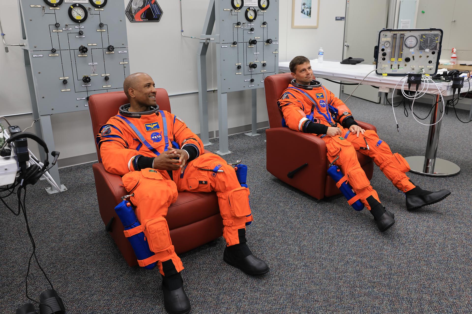
From left, NASA astronauts Victor Glover, Artemis II pilot, and Reid Wiseman, Artemis II commander, conduct leak checks on their spacesuits inside the crew suit-up room in the Neil A. Armstrong Operations and Checkout Building at the agency’s Kennedy Space Center in Florida on Wednesday, April 1, 2026, ahead of the Artemis II test flight.
Credit: NASA/Kim Shiflett
Following their landmark Artemis II mission earlier this year, distinguished NASA astronauts Victor Glover and Reid Wiseman are transitioning in September to emeritus status at the agency’s Johnson Space Center in Houston.
In an emeritus role, individuals with a high degree of technical and professional knowledge can continue to support the agency by donating their time to train and mentor the current workforce. This allows the agency to maintain access to top talent in a specialized consultant role, while simultaneously providing the individual with the flexibility to pursue other opportunities.
“I’ve had the privilege of knowing Reid and Victor for years, and both exemplify the leadership, character, and commitment that define NASA at its best.” said NASA Administrator Jared Isaacman. “Reid commanded Artemis II after previously spending 165 days aboard the International Space Station, while Victor brought his experience as a naval aviator, test pilot, and Crew-1 astronaut to his role as pilot. Together, they took on one of the most challenging missions in human spaceflight and helped return America to the lunar environment. As Reid and Victor transition to emeritus status, I’m grateful they will continue sharing what they learned with our astronauts, flight controllers, and engineers as we prepare for Artemis III in 2027 and the missions that follow.”
Glover will support aerospace, leadership, and public service efforts as he transitions within and outside of NASA. He’s committed to transferring his knowledge of Orion and its spacecraft systems, among other expertise, to future Artemis missions.
“As I grow into this new role, NASA and spaceflight remain a meaningful part of my journey of service,” said Glover. “I’m excited to keep uplifting my friends and cheering them on as they reach for the Moon. Together, we’ll keep pushing boundaries and inspiring the next giant leap.”
Wiseman is set to share his spaceflight experience with colleagues ahead of the agency’s Artemis III mission in low Earth orbit to test rendezvous and docking capabilities between Orion and commercial human landing systems.
“There is no better place to work, and there are no better people to work with, than those in this agency,” said Wiseman. “NASA gave me tremendous responsibility, supported me through two space missions, and my time as chief astronaut, and was always there for my family when we needed it most. I’m thrilled to continue serving future missions and programs through the emeritus program.”
“Reid and Victor’s commitment to exploration, steady leadership, and service to our astronaut corps and our nation have made a lasting impact,” said Vanessa Wyche, director of NASA’s Johnson Space Center in Houston. “Throughout their careers, they have each brought excellence, humility, and purpose to every role they have held at NASA. Their contributions have helped advance our mission and inspire those around them, leaving a legacy that will continue to shape the future of human spaceflight. We are immeasurably grateful for all they have given to NASA and are glad that this is not the end of their journey with the agency.”
“Reid and Victor are trusted teammates whose professionalism, calm leadership, and unwavering commitment to NASA have strengthened our office and inspired everyone around them,” said Scott Tingle, chief of the Astronaut Office at Johnson. “As they transition into their emeritus roles, they leave a legacy of operational excellence that will continue shaping the astronaut corps for years to come. We’re grateful that they will still be part of our community, sharing their experience and insight as they begin this next chapter.”
Among their many accomplishments at NASA, as Artemis II crew members, Glover and Wiseman were two of the four astronauts to first launch on top NASA’s SLS (Space Launch System) rocket aboard the Orion spacecraft for a mission around the Moon. Following a 10-day mission with crewmates NASA astronaut Christina Koch and CSA (Canadian Space Agency) astronaut Jeremy Hansen, they safely splashed down on April 10 as the first humans to travel to lunar orbit in more than 50 years, ultimately flying farther in space than anyone had before.
Support and knowledge transfer from both Glover and Wiseman is critical for the upcoming Artemis III mission as NASA prepares to return American astronauts to the lunar surface on the Artemis IV mission in 2028.
Curiosity Blog, Sols 4995-5001: 5,000 (Martian) Days on Mars
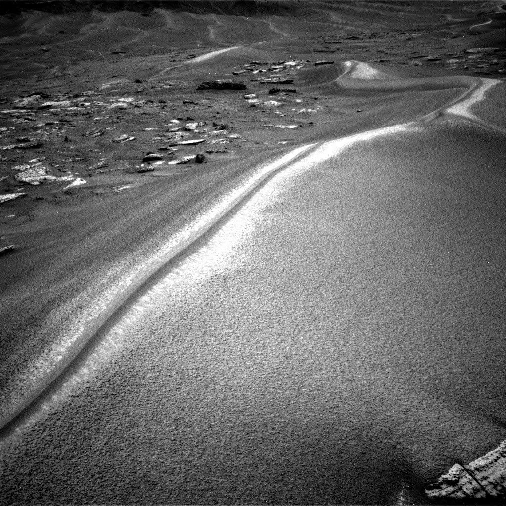
NASA’s Mars rover Curiosity acquired this image along Chocolatal ripple using its Right Navigation Camera on Aug. 28, 2026 — Sol 4998, or Martian day 4,998 of the Mars Science Laboratory mission — at 13:58:36 UTC.
NASA/JPL-Caltech
Written by William Farrand, Senior Research Scientist, Space Science Institute
Earth planning date: Friday, Aug. 28, 2026
The span of sols spanned by this blog post is noteworthy in several ways. First, Curiosity became a world-class (for Mars at least) mountaineer by passing the 1 kilometer mark of elevation from its landing site on the floor of Gale crater. This writer was on the Mars Exploration Rover science team and we were excited when the Spirit rover got to the top of Husband Hill in Gusev crater in August 2005. But that was a climb of 106 meters (about 348 feet) above its landing site, and Curiosity has passed 1000 meters (about 0.62 miles).
Second, Saturday, Aug. 29, marked 5,000 Martian days (or sols) since Curiosity landed on Mars (that’s more than 5,137 Earth days, because a day on Mars lasts 24.6 hours). Congratulations are in order to the engineers and scientists who have made this landmark possible.
Finally, in terms of its science activities Curiosity is examining a wind-formed, long, narrow, large ripple which has been named “Chocolatal.” Further examination will help determine if this feature could be classified as a “transverse aeolian ridge” or TAR. TARs have been observed across the Martian surface based on orbital imaging. The long axis of a TAR is oriented perpendicular to the local predominant wind direction. While this is not the first potential TAR that has been examined by Curiosity, its location, higher on the slopes of Mount Sharp invites questions about whether it will be composed of the same types of granular materials found in the lower TARs, or whether it has a different range of grain sizes and/or layering.
Other questions to be addressed include how the ridge formed, whether it is active, how it has migrated, and, if it is immobile, then how has it stabilized?
At the start of the planning week, Curiosity was en route to the sand ripple and encountered interesting science targets along the way. In Monday’s two-sol plan, in-situ examinations were planned of the light-toned bedrock occurring along the rover’s path. Some of the rocks encountered near the rover had dark-toned thick coatings or remnant layers, and these were targeted for chemical examination by the rover’s ChemCam Laser Induced Breakdown Spectroscopy (LIBS) instrument. Mastcam and ChemCam Remote Micro Imager (RMI) mosaics were planned, for layers in buttes along the rover’s path, and on more distant sets of sand ripples.
A midweek planning session took advantage of the last drive, leaving the rover only a few meters from Chocolatal. ChemCam was able to target sand at the base of Chocolatal as well as nearby bedrock. Stand-off Mastcam high-resolution image mosaics of the ripple were also targeted. The drive planned midweek took the rover right into Chocolatal with one of its wheels and then backing off a little, so in the end-of-week plan, contact science could be planned within the trenched region.
The final planning session of the week, which extended through the landmark Sol 5000, involved MAHLI mosaics of the right wall of the trench to see if there is layering, and to assess any variations in grain size. It’s noteworthy that these MAHLI mosaics are being named in honor of our late colleague Paul Geissler, who was one of the foremost experts on the study of Martian TARs and who was working with the MAHLI team before his untimely passing earlier in the year. In-situ APXS measurements were planned of the coarse-grained surface of the ripple, and ChemCam LIBS measurements were planned on the top of Chocolatal, a sinuous feature looking like a “mohawk” haircut (see the accompanying image). LIBS was also planned on a dark band on its flank and at the back of the scuff/trench. Other activities in the three-sol plan included Mastcam mosaics, an AM Navcam dust-devil survey, Navcam suprahorizon survey, and APXS atmospheric measurements.
With 5000 sols of outstanding scientific accomplishments, the Curiosity science and engineering team looks forward to the next 5000 sols.
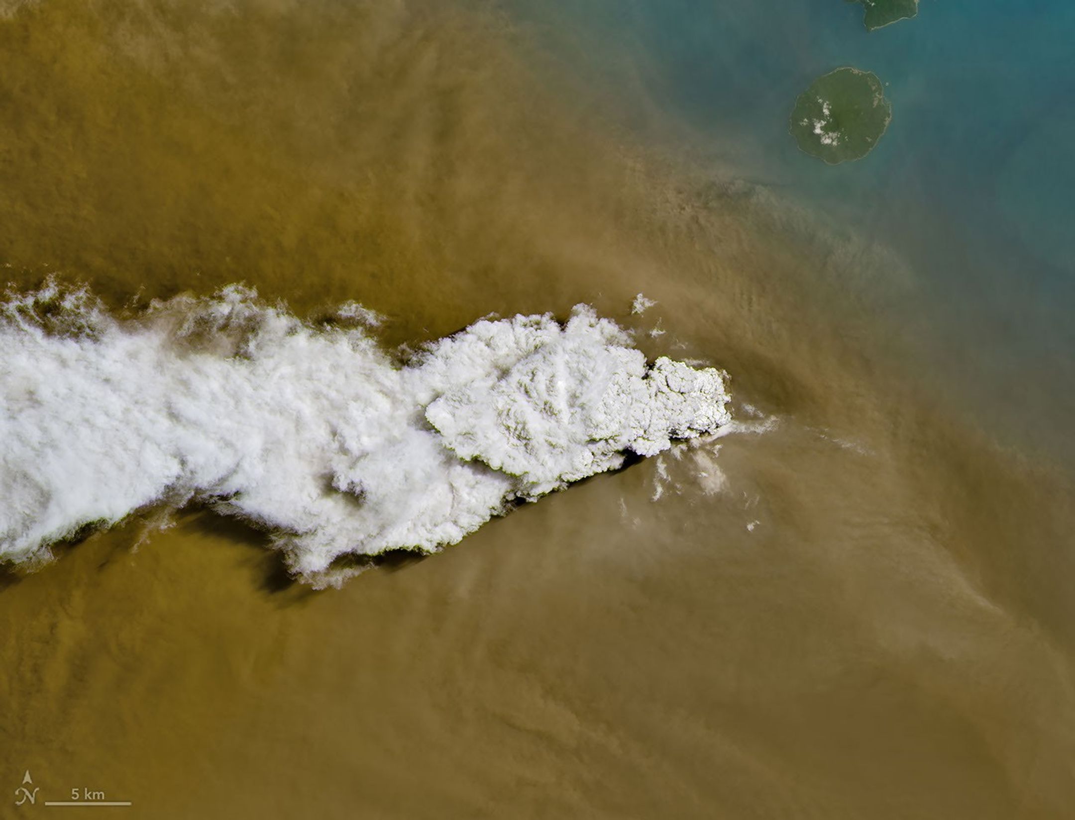
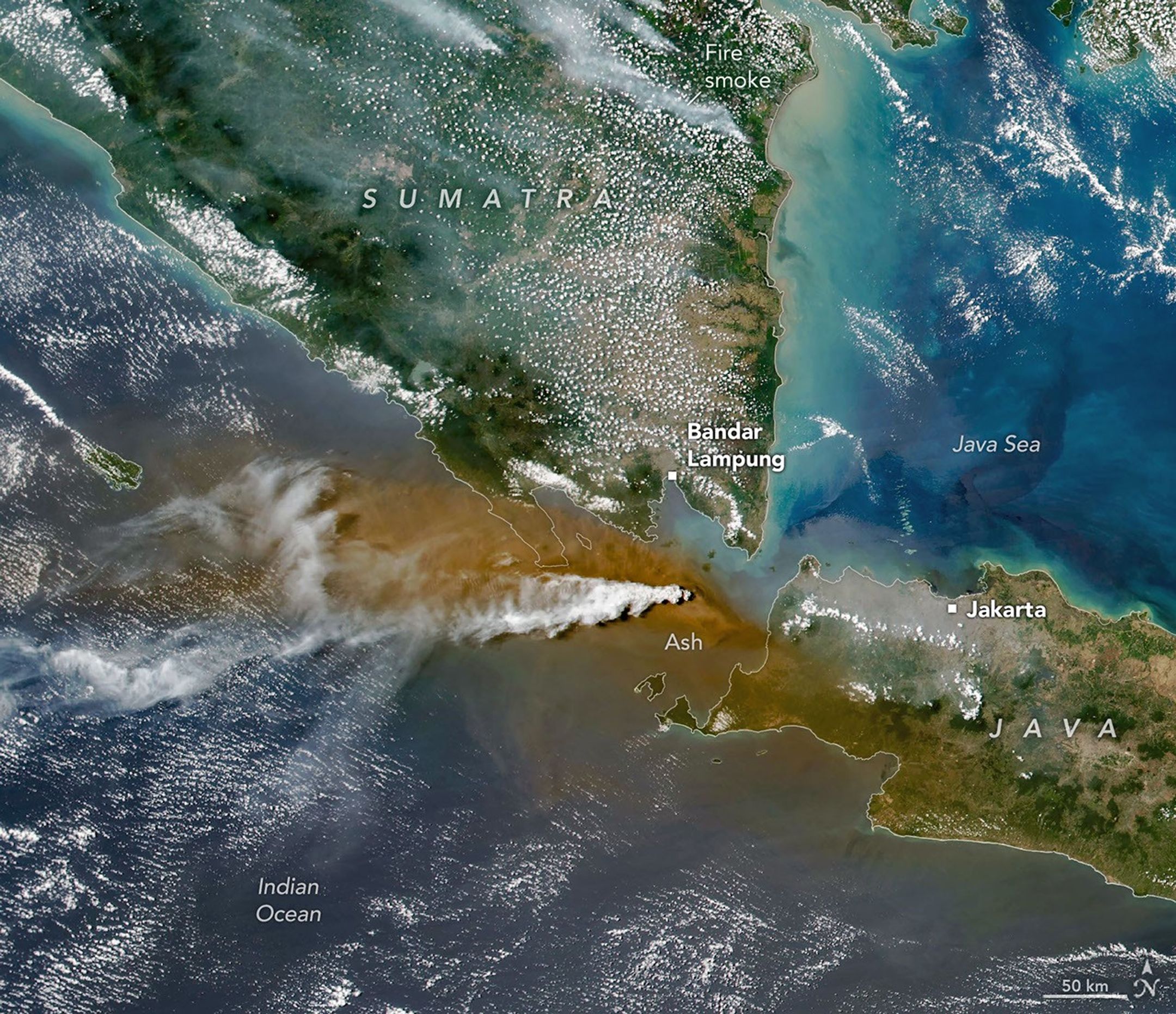
Anak Krakatau erupts ash and volcanic gases in this image acquired with the OLI (Operational Land Imager) on Landsat 8 on September 5, 2026.
NASA Earth Observatory/Michala Garrison
Eruptions are a regular occurrence at Anak Krakatau, a small volcano between the Indonesian islands of Java and Sumatra. Much of its activity remains relatively mild, but it occasionally puts on more impressive and hazardous shows of force. In early September 2026, a booming eruption lasting more than 24 hours sent gas and ash high into the atmosphere, disrupting thousands of flights and degrading air quality in parts of the country, including the capital city of Jakarta.
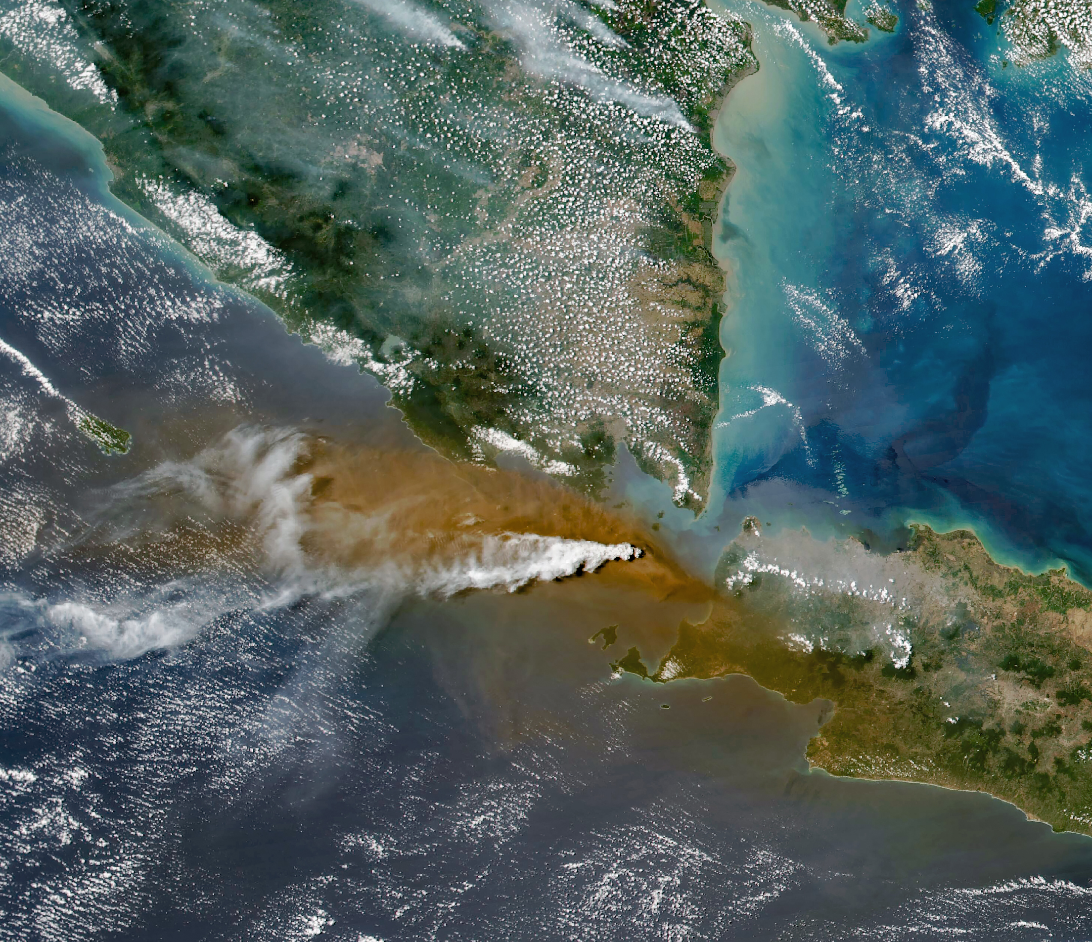
Satellites passing over the area during the eruption on September 5 captured images of the explosive activity. In the scene above, acquired with the OLI (Operational Land Imager) on the NASA-USGS Landsat 8 satellite, a white plume of volcanic gas billows over a brown ash cloud. Below, a wider view captured by the VIIRS (Visible Infrared Imaging Radiometer Suite) on the Suomi NPP satellite shows the volcanic material dispersing over a large area.
Indonesia’s meteorological agency reported that ash had reached altitudes up to 6,000 meters (20,000 feet) to the east of the volcano and 15,000 meters (50,000 feet) to the west by September 6. The presence of ash in the atmosphere prompted the temporary closure of eight airports on Java and Sumatra, disrupting nearly 3,000 flights in and out of the area, according to news reports.
Plumes of ash and volcanic gases from Anak Krakatau drift over Indonesia and the Indian Ocean in this image captured by the VIIRS (Visible Infrared Imaging Radiometer Suite) on the Suomi NPP satellite on September 5, 2026.
NASA Earth Observatory/Michala Garrison
Ashfall affected populated areas, particularly to the east of Anak Krakatau in Jakarta and other parts of West Java, the Indonesian Humanitarian Coordination Platform (IHCP) reported. Volcanic ash poses health risks to people and can irritate the respiratory tract, eyes, and skin. However, this air quality hazard differs from the smoke produced by peatland fires elsewhere in the country in terms of particle characteristics, dispersal patterns, and protection measures, the IHCP noted.
On September 6, the continuous explosive eruption from Anak Krakatau subsided, though the volcano kept rumbling. It returned to a more typical pattern of Strombolian eruptions, characterized by intermittent spurts of ash and volcanic material. Airports had resumed operation by September 8, but the volcano remained at the second-highest alert level on the country’s scale, as it has been since early July.
Jaden Caradine knew he wanted to be an engineer at eight years old. He just took a winding road to get there.
Before he enrolled at Embry-Riddle Aeronautical University, before he discovered the field that would become his focus, and before he landed a Pathways internship at NASA’s Langley Research Center in Hampton, Virginia, Caradine spent five years as a mechanic in the United States Marine Corps, four of them stationed in Japan. It was a deliberate detour, one that shaped how he approaches everything since.
“I’ve kind of always known I wanted to be an engineer,” he says. “I just had to figure out what kind.”
NASA Pathways intern Jaden Caradine
Credit: NASA
Finding the Overlap
Caradine grew up in the Salt Lake City area, raised by a mother who put him on a snowboard at four and on a rock face not long after. He was the kind of kid who learned to love science not for its own sake, but for what it could do. “Math is an enabling skill,” he says. “It’s not about doing the math. Math has a purpose and it’s useful.”
By the time someone asked young Jaden what he wanted to be, the answer was immediate. “I was building Legos,” he says, “and I just thought — I want to build stuff. I can’t really see myself being anything other than an engineer.”
Right out of high school, Caradine enlisted in the Marines, trained as a mechanic, and shipped out to Japan. During those five years, between the technical work and the distance from home, he started reading books on decision-making, career planning, and long-term thinking. He found a framework he keeps coming back to: ikigai, a Japanese concept that maps the intersection of what you’re good at, what you enjoy, what the world needs, and what you’re paid to do.
Caradine at the Sapporo Snow Festival in Hokkaido, Japan, while serving as a U.S. Marine Credit: Jaden Caradine
“Your ikigai is the thing where all of those overlap,” he says. Engineering was already in the picture. The question was what kind.
Chasing the Signal
The answer arrived through research and a company Caradine stumbled on while scanning the landscape of emerging aerospace technology. They were using magnets to spin a launch system to 14,000 or 15,000 RPM and release small satellites into orbit, recovering the energy on the way down through the same magnetic system. “I thought that was awesome,” he recalls. “So, I started looking into aerospace engineering, and it was a good fit.”
Once he had the field, the destination wasn’t hard to find. Caradine transferred to Embry-Riddle Aeronautical University’s Daytona Beach campus to study aerospace engineering and immediately started showing up everywhere he could — satellite conferences at Kennedy Space Center, industry events in Orlando, small satellite gatherings back in Salt Lake City. “I went to all the career fairs, even though I wasn’t looking for a job yet,” he says. “I just wanted to learn as much as I could, as fast as I could.”
At every NASA booth, he asked questions. He learned about Pathways, the program that places undergraduate and graduate students at NASA centers with the potential to convert to full-time civil service positions, but he waited a year to apply. “I hadn’t really done the things I wanted to do in order to write a strong application yet,” he says. He wrote the next application with the intention of using it as a practice run. He got in.
His reason for choosing NASA over industry was simple and firm. “NASA doesn’t work for profit,” he says. “We’re here to remove barriers so that industry can eventually do the things they weren’t able to do before.”
“Human beings are far more capable than we give ourselves credit for. A journey of a thousand miles starts with a single step and can only be taken one step at a time.”
Work Worth Doing
At NASA Langley, Caradine is part of the Systems Analysis and Concepts Directorate, where “we help agency leaders figure out why they should make certain decisions, especially those that have lots of moving parts,” he explains. Specifically, he works with the in-space servicing, assembly, and manufacturing (ISAM) team, a group focused on the emerging field of building and maintaining infrastructure in space, rather than simply launching and discarding it.
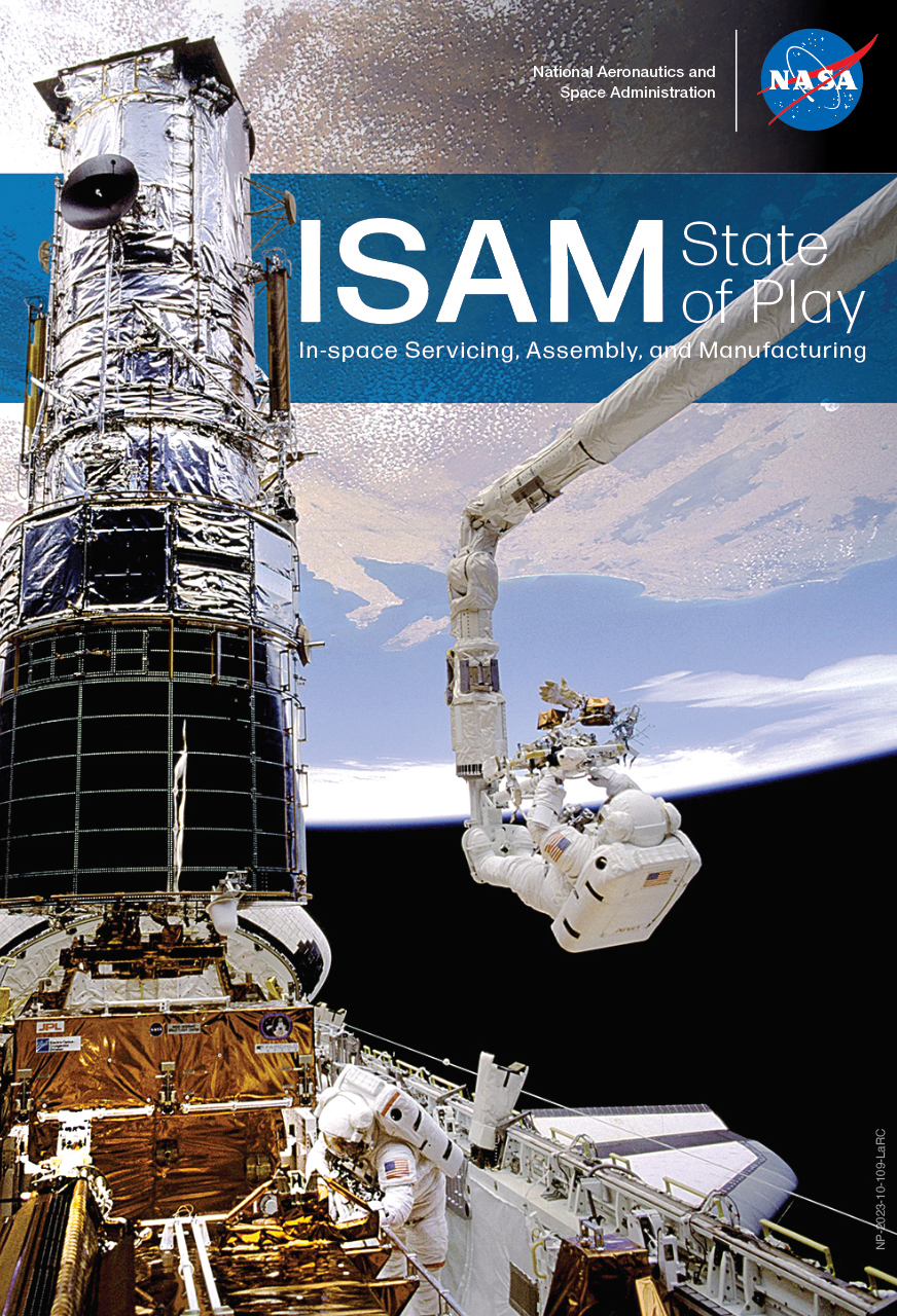
A major part of his summer was curating the State of Play, a comprehensive document that consolidates everything happening in the ISAM sector across government, academia, and industry into a single, navigable resource.
“Jaden joined the team and immediately contributed to this year’s State of Play update,” says Dale Arney, aerospace engineer and Caradine’s mentor. “He also created an automated tool that will help the team create future updates more quickly.”
The ISAM State of Play document is a survey of past, present, and near-future ISAM capabilities across industry, academia, and government agencies.
Credit: NASA
That tool scrapes aerospace news from across the web, compiles relevant updates into organized tables, and produces a readable summary on a regular cadence. “It kind of replaced the need for everyone on the team to spend 30 or 40 minutes every day scrolling through news to keep up,” he says.
“Jaden was constantly looking for ways to improve himself, the team, and our products,” Arney adds. “He was eager to take the lead in trying a number of new processes and ideas to try to make them work for us.”
No Silos
The thing that surprised Caradine most about NASA Langley had nothing to do with the technical work. He had expected some departmental siloing that could develop in large organizations, where people become experts in narrow areas with limited cross-pollination among teams.
“That’s not something I’ve experienced here,” he says. “We all talk to each other, across all teams. We share resources. We collaborate quite extensively.” He describes a culture that expects everyone to engage with the whole problem, not just their corner of it. “Everyone kind of bounces around on different teams to learn the whole aspect of the problem and support each other.”
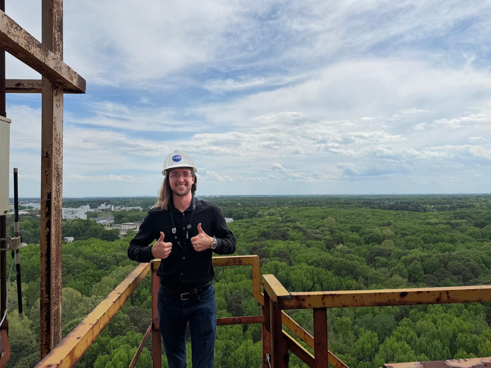
Caradine at NASA Langley’s Impact Dynamics Facility, enjoying the view at the top of the gantry
Credit: NASA
For anyone considering the Pathways program, his advice is direct. “Do it,” he says. “Human beings are far more capable than we give ourselves credit for. If it seems like too much, break it down. A journey of a thousand miles starts with a single step and can only be taken one step at a time.”
Caradine heads back to Embry-Riddle as a junior this fall, with plans to return to Langley next summer. Grad school is on the horizon, and he’s exploring programs that nurture important analysis skills for SMAB, including decision, strategic, and systems analysis.
“Before coming here, I was trying to do everything and cast a wide net,” he says. “Now I know what I need to know how to do. That’ll give me the opportunity to focus my efforts on the high-value skill sets.”
On Caradine’s Sci-Fi Shelf
The Sirens of Titan by Kurt Vonnegut
Dungeon Crawler Carl by Matt Dinniman
Caradine’s instinct runs more toward fantasy than science fiction, but this one, he says, hits something real.
“I enjoy the leveling aspect — constantly improving, constantly getting better. In books it might be physical strength, but in reality, strength takes on many different forms. Constant improvement is quite rewarding in real life, as it is in books.”
The audiobook production, he adds, is its own experience: full sound design, character actors, the works. “It’s like listening to a movie.”
The team also recently convinced him to start Dune, by Frank Herbert. He’s about halfway through.
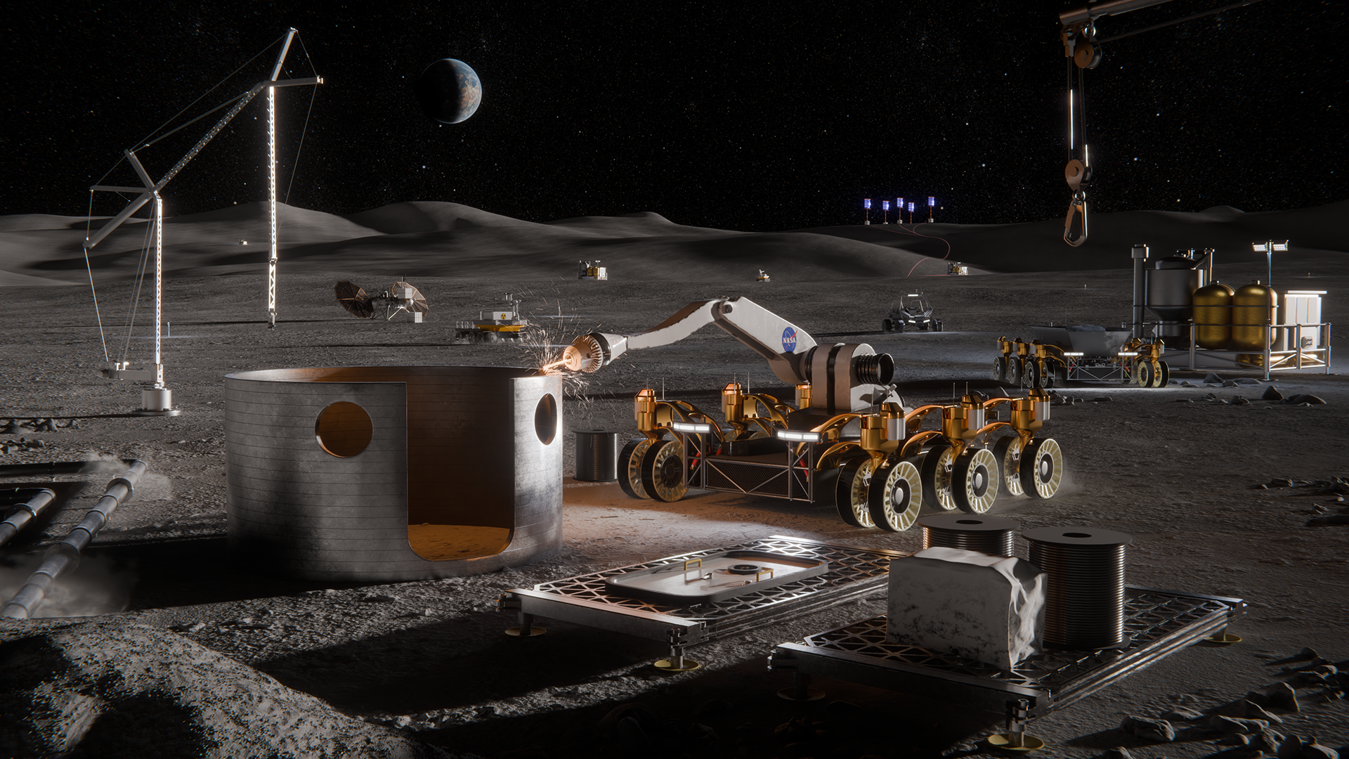
Artistic concept of lunar surface technologies and infrastructure capabilities, including in-situ resource utilization oxygen production systems, surface power systems, in-space manufacturing tools, and advanced nanomaterials production.
Credit: NASA
NASA is seeking proposals to advance the technology and infrastructure needed to explore the Moon and establish a Moon Base in the lunar South Pole region.
Announced on Tuesday, Sept. 8, the solicitation targets capability gaps, including power generation, oxygen extraction, and producing materials on the Moon required for construction and operations. These technologies are essential to making humanity’s next great leap in lunar exploration.
“NASA is accelerating the development of key technologies and closing critical gaps needed for long-term human exploration at the Moon,” said Greg Stover, director of NASA’s Advanced Research and Technology Division. “Partnering with industry will strengthen the U.S. industrial base as we mature the capabilities and infrastructure needed for a sustainable lunar presence.”
The NextSTEP-3 Broad Agency Announcement Appendix A: Lunar Enabling Infrastructure Accelerator solicitation aims to mature and demonstrate capabilities in five areas:
Vertical solar array technology that can provide consistent power generation, management, distribution, and energy storage.
In-situ resource utilization oxygen from regolith production to extract usable oxygen molecularly bonded to rock and dust covering the Moon’s surface.
Radioisotope Stirling generator, a type of nuclear energy technology that uses heat from fissile materials to produce electric power for operating spacecraft systems in the darkest, dustiest, and most remote places.
In-space advanced manufacturing to reduce reliance on resupply missions from Earth and to optimize mission flexibility and resilience on the Moon.
Innovative nanomaterials production to advance the commercial availability and quality of nanomaterials that can be used in lunar exploration.
The solicitation intends to cultivate U.S.-led capabilities while maintaining full and open competition among private industry, academic institutions, and not‑for‑profit entities, as well as international partners participating through U.S.-led teams.
NASA may apply insights gained from the resulting contracts of this solicitation, such as technical data, and demonstration results, to shape future acquisition strategies.
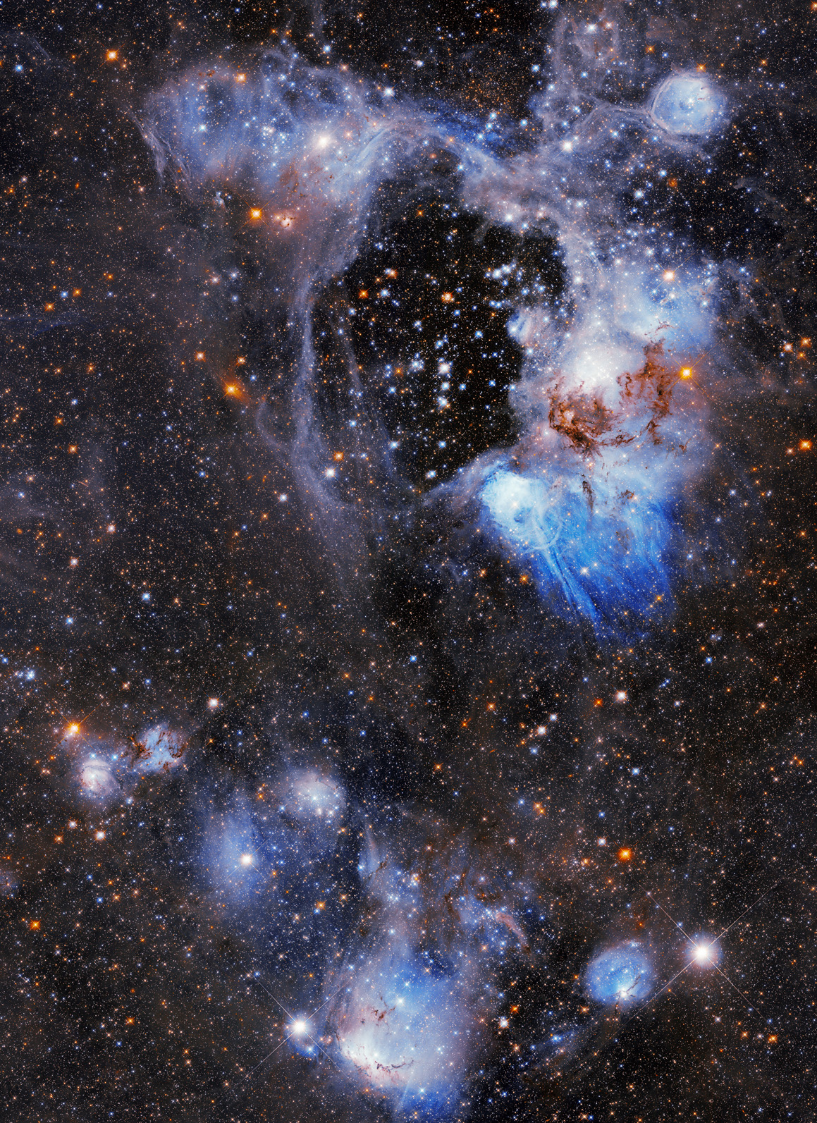
NASA’s Hubble Space Telescope captures a photogenic nebula, N44, in the Large Magellanic Cloud in this Sept. 3, 2026, image. N44 is dominated by two features: a vast central void and a shell of dense, dusty gas. The central void is a ‘superbubble’ spanning roughly 210 by 140 light-years across. The glittering stars at the center of the void are responsible for its creation; through their powerful stellar winds and explosive supernovae, these stars expelled much of the gas from which they were born.
Preparations for Next Moonwalk Simulations Underway (and Underwater)
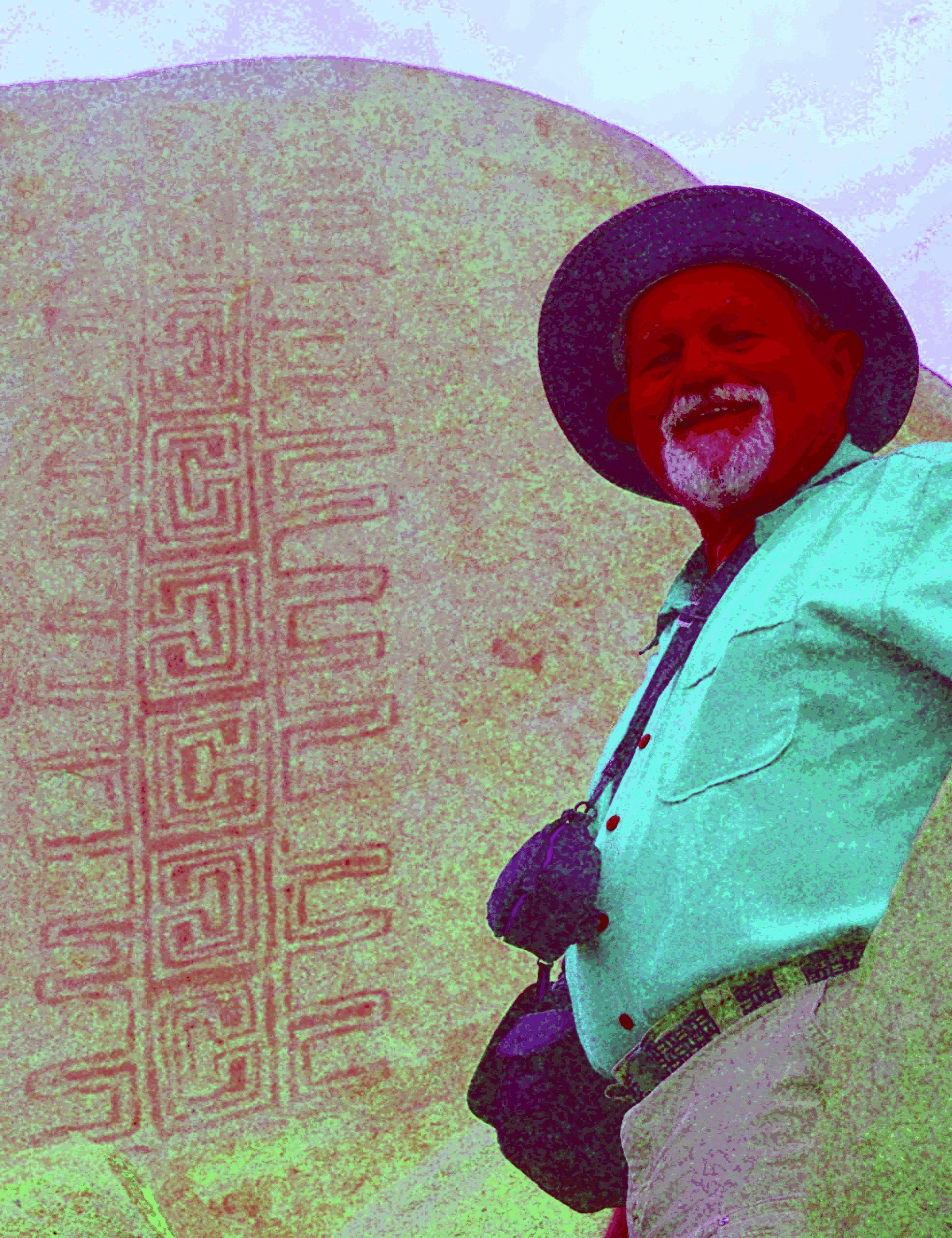
Jon Harman poses in front of an example of the Rancho Bernardo style of Native American artwork that’s barely visible until Dstretch is applied.
Credit: Jon Harman
High in the central tower in the ancient Cambodian temple of Angkor Wat, paintings depict horseback riders and a traditional musical ensemble. Thousands of visitors pass these images daily without noticing, because they’re faded to the point of invisibility.
They were discovered between 2010 and 2012, along with about 200 other paintings throughout the complex, by an archaeologist using a method conceived at NASA’s Jet Propulsion Laboratory in Southern California.
The technique, known as decorrelation stretch, heightens contrasts in digital imagery, making features easier to spot. It is especially popular for studying ancient rock art, partly due to the chance intersection of one man’s hobby with his professional background.
Around 2005, rock art enthusiast Jon Harman saw NASA images depicting the Martian surface with and without the application of decorrelation stretch. Seeing how much detail the technique revealed, Harman, now retired in Pacifica, California, understood the implication for studying ancient, faded images.
He also worked in medical imaging. “I Googled it and found a NASA paper that explained how to do the algorithm,” he said. “I knew from my medical imaging experience that I could do it, so I did.”
The paper was written in 1996 by Ronald Alley, a JPL employee developing applications for the Advanced Spaceborne Thermal Emission and Reflection Radiometer (ASTER), a Japanese imaging instrument on NASA’s Terra satellite. One of Alley’s former supervisors at JPL had coinvented decorrelation stretch, and Alley had recognized its potential for gleaning information from ASTER imagery.
Harman made his plug-in for use with ImageJ, an open-source program developed by the National Institutes of Health.
before
after
before
after
Before and After
Dstretch applied to Cave of San Borjitas in Baja California, Mexico
As Jon Harman was developing the Dstretch plug-in, he applied it to this image from the Cave of San Borjitas in Baja California, Mexico. When the yellow figure appeared in the middle of the picture, he knew he had something useful. Credit: Jon Harman
He said he fulfills about 200 requests for Dstretch per year. Around 2010, he also created smartphone apps that use a shortcut to mimic decorrelation stretch. The apps have been downloaded thousands of times, and papers have been published describing Dstretch’s usefulness in archaeology.
It has been used to spot and clarify imagery at ancient sites under a cliff in Norway, in an Egyptian tomb, at a park in Canada, and in many other locations. It has also helped archaeologists find buried remains of ancient Greek buildings and examine tattoos on mummified human remains, among its non-rock-art applications.
Harman said he was not surprised Dstretch found wide use in the rock art community. “But I’ve been surprised by a lot of the different applications people have found. So that’s been cool.”
1,000 Museum Visitors Dive Into NASA Sea Level Science on World Ocean Day
Participants reach into an augmented reality sandbox, reshaping the terrain as projected contour lines and colors illustrate topographic features and elevation changes.
University of Georgia Marine Extension and Georgia Sea Grant
More than 1,000 visitors explored NASA sea level science firsthand during World Ocean Day at the University of Georgia Aquarium on Skidaway Island on June 6, 2026. The free event was supported by NASA’s Science Activation program through the Sea Level Education, Awareness, and Literacy (SEAL) project – a national effort that connects NASA sea level rise data with educators and coastal communities, particularly those historically underserved and already experiencing sea level impacts.
SEAL is a partnership between NASA and four NOAA Sea Grant programs working together to expand sea level rise understanding across U.S. coastal regions. By co-developing lesson plans, interactive activities, and place‑based learning experiences, SEAL helps educators engage learners with real NASA observations, models, and projections while strengthening community resilience to climate change.
During World Ocean Day, SEAL partners at Marine Extension and Georgia Sea Grant and the Coastal Equity and Resiliency Hub at Georgia Tech led hands‑on activities that brought sea level science to life. Visitors played the “Tumbling Tower” game, where removing blocks represents different community impacts from rising seas, and made “sea level friendship bracelets” that used colored glass beads to represent observed sea level rise along local coastlines.
The event also marked the debut of a new augmented reality sand box developed through SEAL. Guests shaped sand into coastal landscapes and watched NASA-informed sea level rise projections transform their creations in real time. Participants could experiment with resilience strategies, such as adding dunes or relocating homes, to see how adaptations might help communities prepare for future change.
Educators – formal, informal, home-based, and more – attending the event were able to take home four different SEAL lesson plans designed for both classrooms and informal learning settings. These materials help students explore sea level rise processes, modeling, variation, and impacts through NASA data and interactive STEM activities. SEAL aims to make all lesson plans developed through the project available online, but until then, please email Shannon Matzke to request digital copies.
“World Ocean Day is an annual tradition at the UGA Aquarium,” said Shannon Matzke, Marine Educator and Public Program Coordinator at UGA Marine Extension and Georgia Sea Grant. “With the support of NASA’s Science Activation program, this year’s event was free, which allowed us to reach more people and different audiences than we typically see. Incorporating SEAL activities made the day even more impactful for visitors – many of whom live in coastal communities already experiencing the effects of sea level rise.”
The SEAL project is supported by NASA cooperative agreement award number NNH21ZDA001N-SCIACT and is part of the NASA Science Activation Program portfolio, which connects learners with authentic NASA science experiences through partnerships with educators and community organizations.

 Login