❌

Reading view

Curiosity Blog, Sols 4968-4974: Rock Climbing Towards the Discontinuity

3 min read

Curiosity Blog, Sols 4968-4974: Rock Climbing Towards the Discontinuity
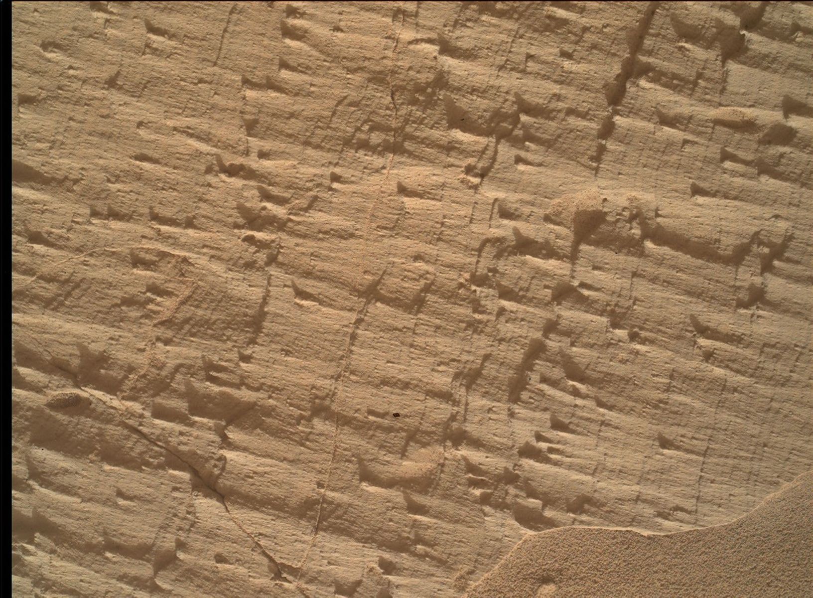
A close-up color photograph taken by the Curiosity rover showing a rough, tan-colored rock surface on Mars. The rock is highly textured, covered in fine parallel layers, small raised ridges, and thin cracks that cast tiny shadows. In the bottom right corner, a small drift of smooth, fine sand rests against the jagged rock.
NASA’s Mars rover Curiosity acquired this image, a frame of the “Longquimay” mosaic showing fine-scale sedimentary textures in a bedrock block near the supersurface, using its Mars Hand Lens Imager (MAHLI), located on the turret at the end of the rover’s robotic arm. Curiosity acquired the image on Aug. 1, 2026 — Sol 4972, or Martian day 4,972 of the Mars Science Laboratory mission — at 23:35:43 UTC.
NASA/JPL-Caltech/MSSS

Written by Lucy Lim, Planetary Scientist at NASA’s Goddard Space Flight Center

Earth planning date: Friday, July 31, 2026

As mentioned in the previous blog, Curiosity has been exploring a large-scale feature in Gale’s sedimentary record suspected to be an “erosional supersurface.” The “supersurface” represents a period in time when a net depositional environment changed to a net erosional one before returning to a depositional regime, thus producing a discontinuity in the rock record. The erosion can involve wind, water, or both. Sometimes there are clues about these environmental changes in the layers below and above the supersurface. So far we’ve been seeing some patterns that look like aeolian features and also some “lens” deposits that sometimes appear consistent with fluvial origins. We need higher-resolution imaging of these features.

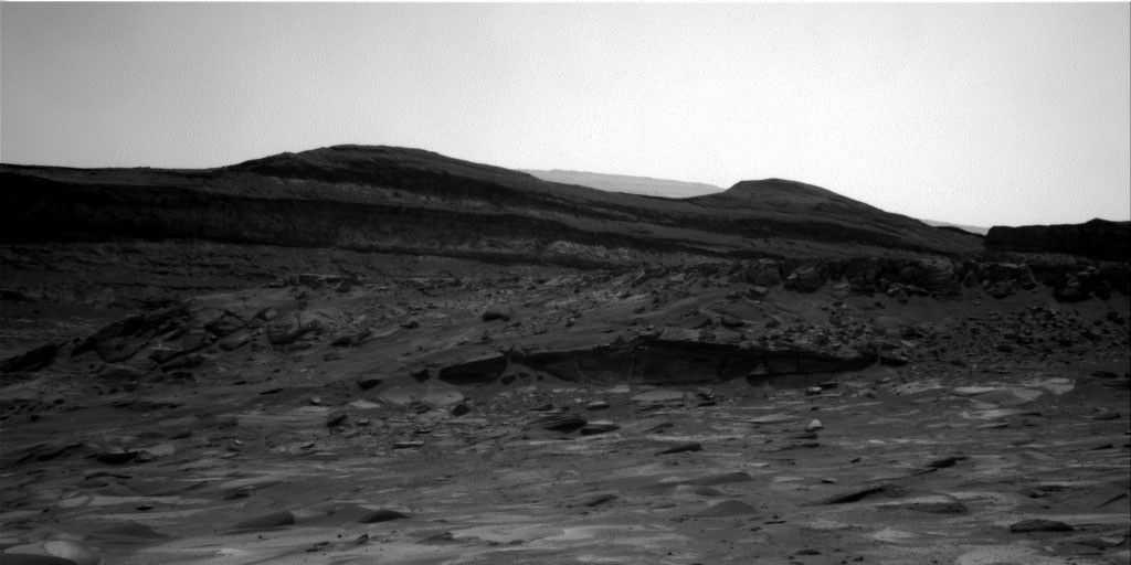
This week Curiosity came within detailed imaging range of a section of the “Cerro Paine Grande” vertical exposure just below the candidate supersurface before climbing on top of it. Mastcam was the star of the show on both planning days this week, capturing large stereo mosaics of the vertical face of the outcrop and a 360-degree panorama after the rover climbed on top of it.

A black-and-white photograph taken by the Curiosity rover on Mars. The rover's mechanical arm extends from the left side of the frame toward the center, revealing a complex cluster of scientific instruments at its end. Below the arm, the Martian terrain consists of large, flat slabs of cracked, textured bedrock. The background is filled with scattered, lighter-colored rocks and patches of dark sand with small wind ripples.
NASA’s Mars rover Curiosity acquired this image, showing the rover arm in action in the “Longquimay” workspace at the top of a steep climb. Curiosity captured the image using its Right Navigation Camera on Aug. 2, 2026 — Sol 4972, or Martian day 4,972 of the Mars Science Laboratory mission — at 00:49:52 UTC.
NASA/JPL-Caltech

Roving to the top took full advantage of Curiosity’s climbing capabilities, leaving the rover at an approximate 24-degree tilt in its final parking spot. The rover planners managed to reach the right posture for contact science at the same time — quite a feat, and one that approached the mission’s contact science tilt record of 27 degrees!

Meanwhile, MAHLI and our geochemical instruments provided detailed characterization of the rock layers beneath the discontinuity. I was the Geology and Mineralogy Theme Lead for the Sol 4968 (Monday) planning cycle, during which “Puyehue” in the light-toned bedrock block of the workspace was co-targeted with APXS, MAHLI, and ChemCam LIBS. The other two targeted LIBS observations in the plan went to a similar-looking nearby bedrock block (“Lago Palena”) and an intriguing layered block off to the side of the workspace (“Piedras Juntas”). Another APXS measurement went to a sand target, “Cormudesi,” which will help us assess the consistency of sand compositions along the rover’s traverse.

In the Sol 4972 workspace atop the slope, the bedrock was sharply divided between a smooth bedding-parallel surface on the local top of the outcrop and the darker-toned, rougher, angled exposure of the same rocks. The light-toned top surface was measured by MAHLI, APXS, and the LIBS at target “Sierra de Sangre,” whereas the darker-toned laminated face was targeted by APXS and MAHLI at “Laguna del Laja.” The fine-scale sedimentary structures in the textured material were also documented by a MAHLI mosaic (“Longquimay”) supported by Mastcam M100 imaging.

Rounding out the week’s science observations were several long-distance ChemCam RMI mosaics on more distant targets such as sedimentary structures above the rover’s current stratigraphic position, and finally our regular cadence measurements of the modern Martian environment, including atmospheric opacity and a ChemCam passive-sky survey to monitor abundances of minor atmospheric gases.
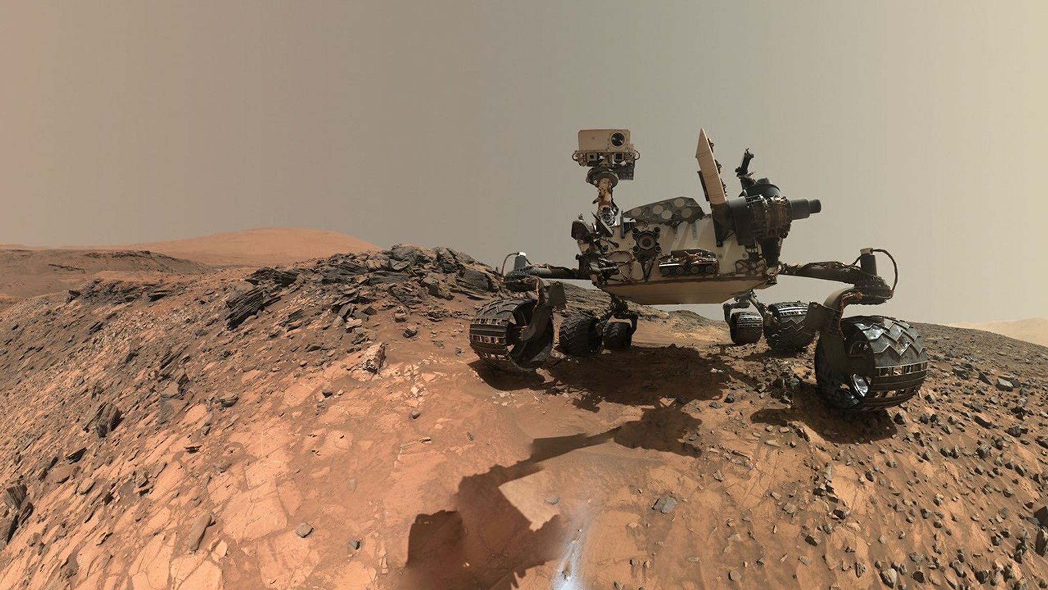
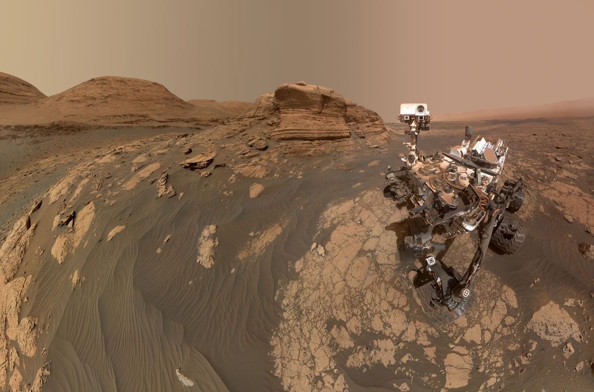
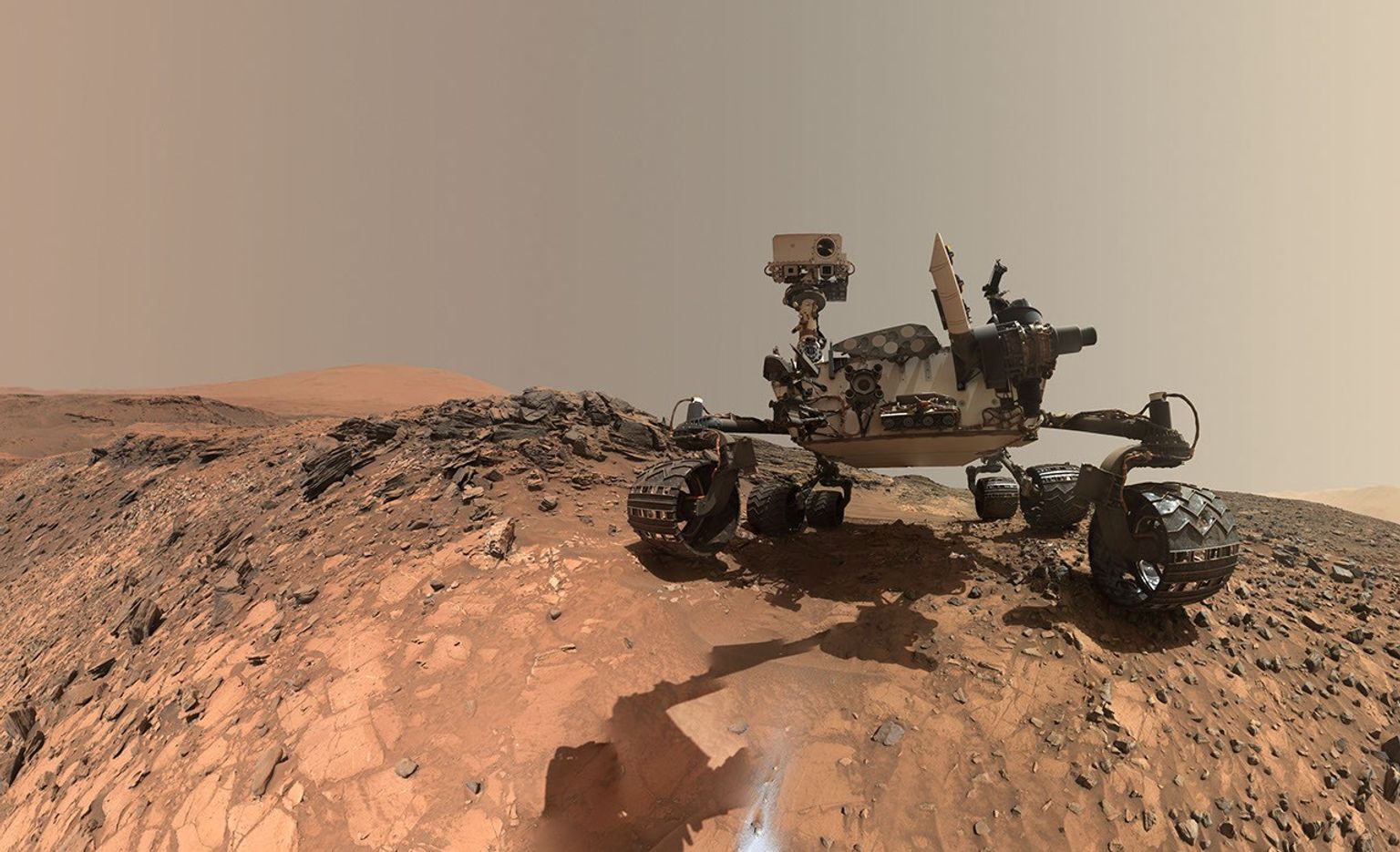
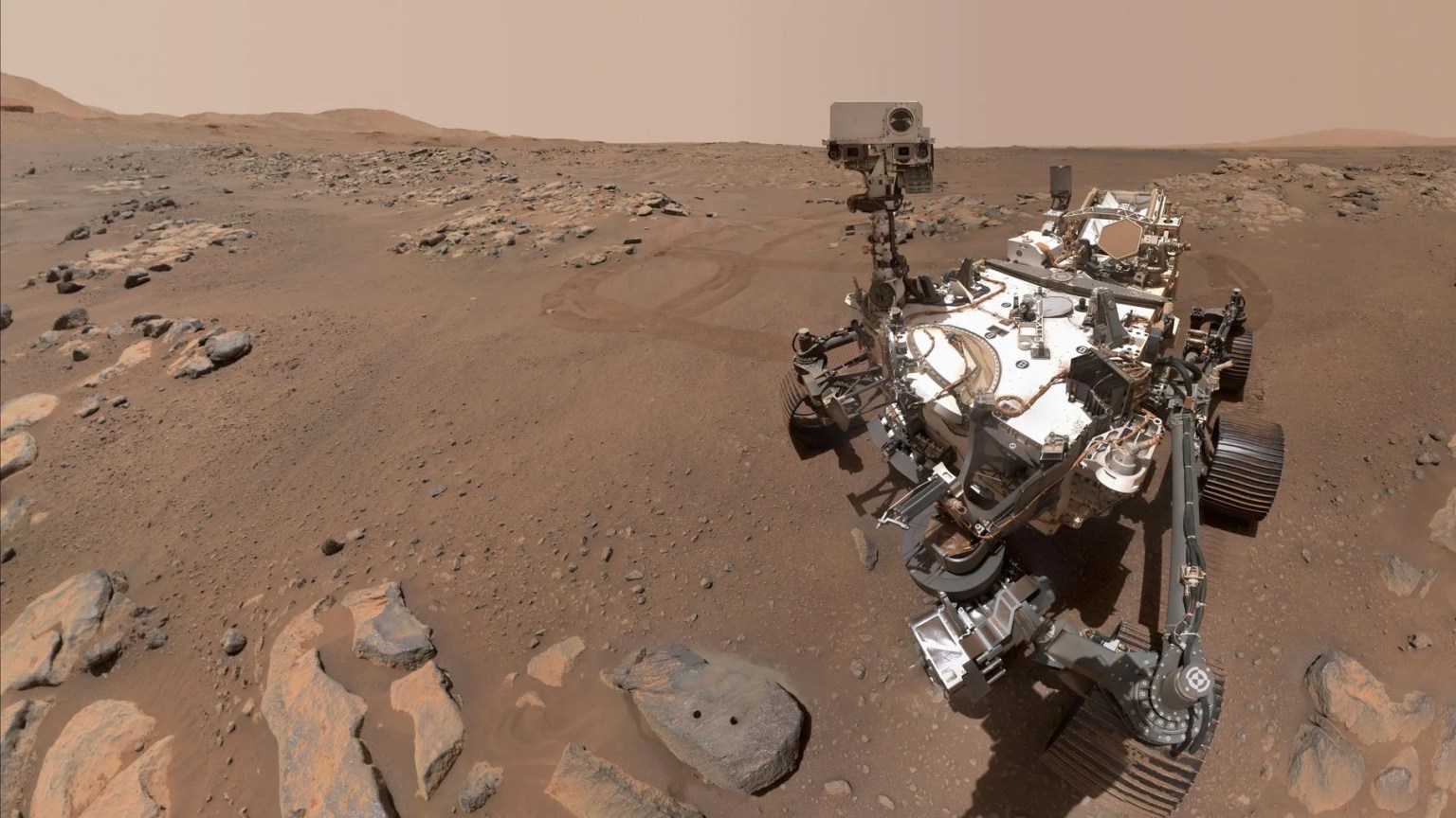
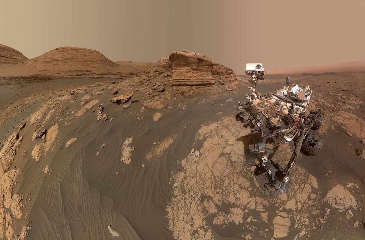
A rover sits on the hilly, orange Martian surface beneath a flat grey sky, surrounded by chunks of rock.
NASA’s Curiosity rover at the base of Mount Sharp
NASA/JPL-Caltech/MSSS

Share

Details

Last Updated
Aug 11, 2026

Related Terms

  •  

APOD: 2026 August 11 – Six Moons of Saturn

APOD

Astronomy Picture of the Day

Discover the cosmos! Each day a different image or photograph of our fascinating universe is featured, along with a brief explanation written by a professional astronomer.

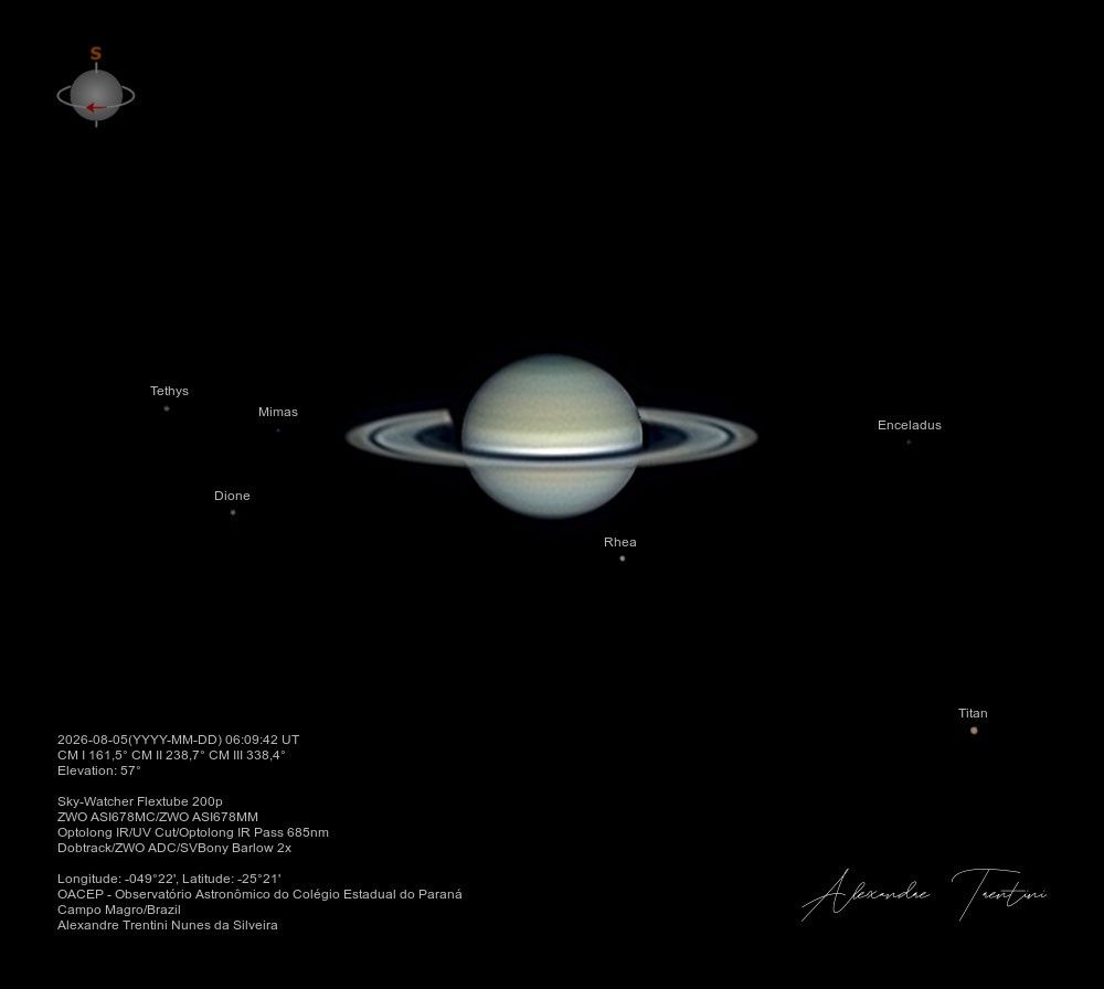
A telescopic image of Saturn with rings and six moons.

Six Moons of Saturn

Explanation: How many moons does Saturn have? While the total will likely continue to grow, as of June 2026 the ringed gas giant had 293 confirmed moons. That’s easily more than any other planet of the Solar System, including ruling gas giant Jupiter with a mere 115 confirmed moons. Most of Saturn’s known moons are small, irregular satellites. Many are only few kilometers to a fraction of a kilometer across and grouped in tilted outer orbits. Six of its largest satellites can be seen here, though, in this sharp telescopic Saturnian family portrait taken on August 5. Larger than Earth’s Moon and even slightly larger than inner planet Mercury, Titan, with a diameter of 5,150 kilometers, is at lower right. You can also spot icy major moons Mimas, Tethys, Enceladus, Dione, and Rhea in the frame. Saturn’s first known natural satellite, Titan was discovered in 1655 by Dutch astronomer Christiaan Huygens. During the space age Voyager and Cassini discoveries have added to the swelling ranks of Saturnian moons.

NASA Stream: August 12 Total Solar Eclipse.
Tomorrow’s picture: pixels in space

Date August 11, 2026
Credit & Copyright: Alexandre Trentini
Authors & editors: Jerry Bonnell, Cecilia Chirenti, Robert Nemiroff, Keighley Rockcliffe
A service of: ASD at NASA / GSFC,
NASA Science Activation & Michigan Tech. U.
  •  

Bountiful Roebuck Bay 

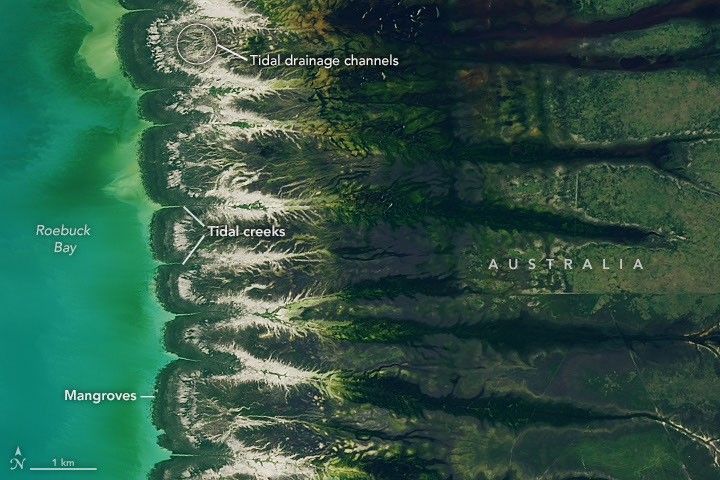
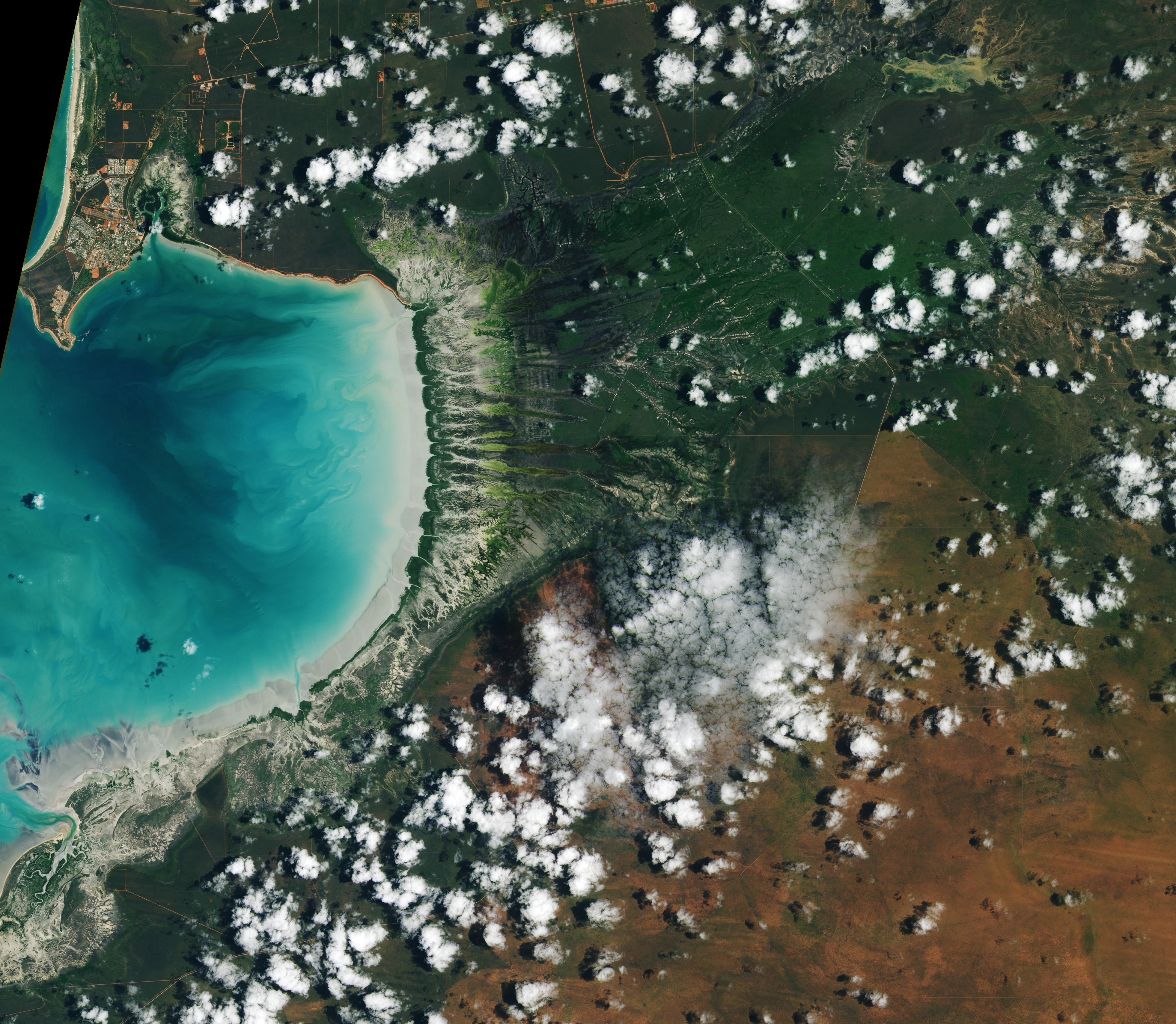
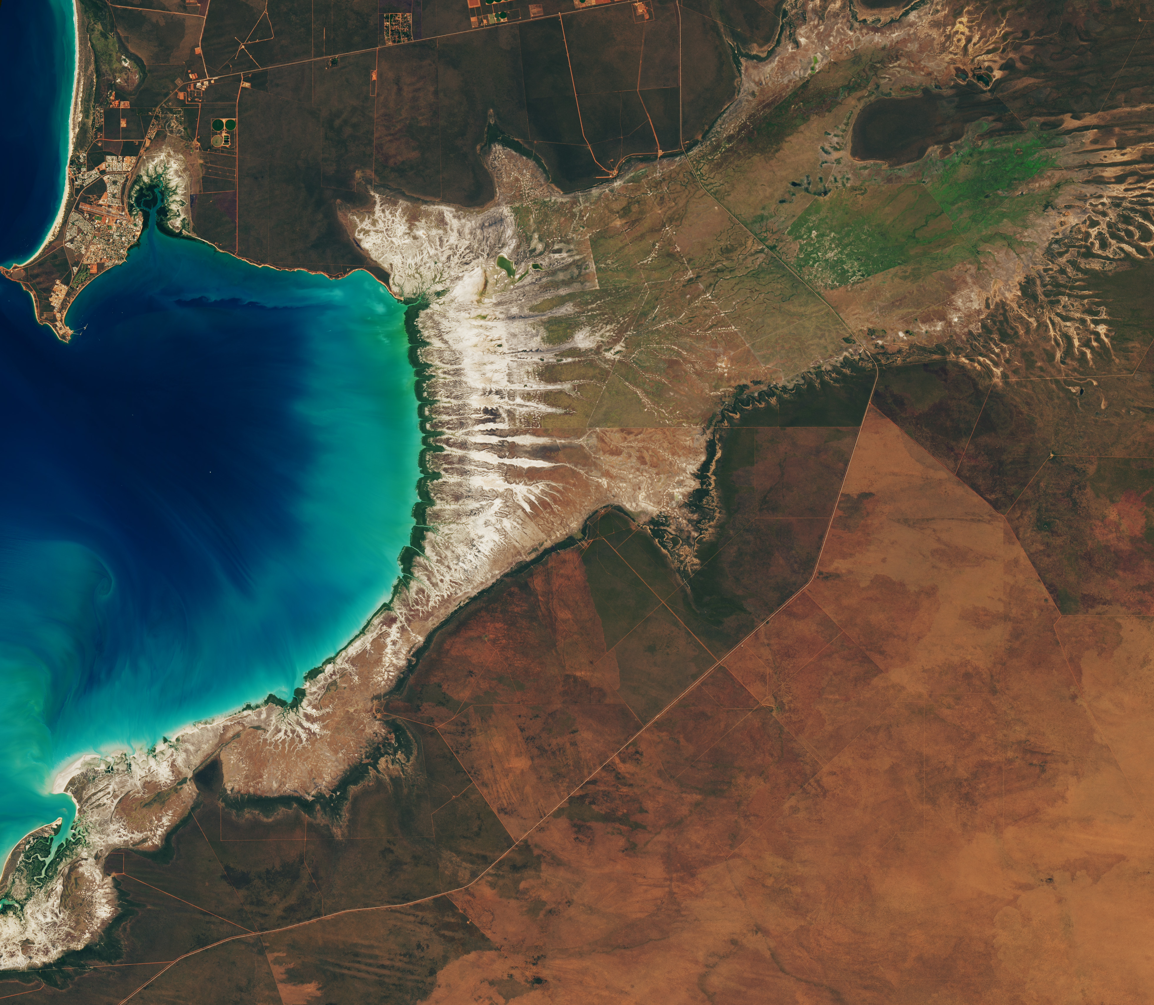
Blue coastal waters border a fringe of dark green mangroves with branching, linear tidal creeks and pale tidal flats and drainage channels visible to the east.
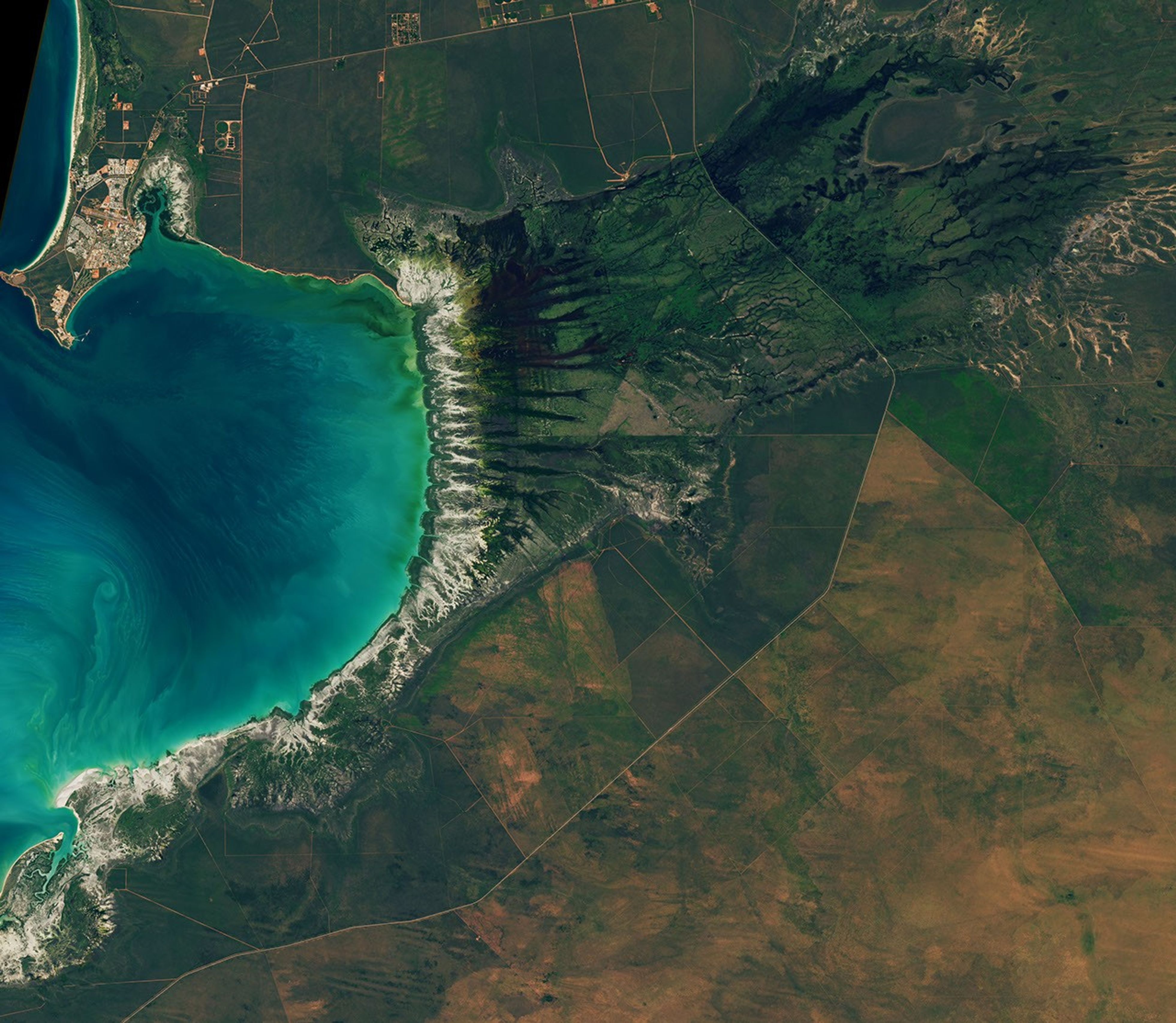
Water covers intertidal mudflats around Roebuck Bay in Western Australia, as seen in this image captured by the OLI (Operational Land Imager) on Landsat 8 on March 18, 2026.
NASA Earth Observatory / Lauren Dauphin

Editor’s Note: Today’s story is the answer to the August Puzzler.

Tides are among the clearest signs of the Moon’s pull on Earth. Just 239,000 miles (385,000 kilometers) away, the Moon’s gravity pulls on Earth’s oceans and solid crust, subtly distorting them into a more oblong shape with bulges roughly extending toward and away from the Moon.

High tides happen throughout Earth’s oceans, but in some places they leave an unusually strong fingerprint on the landscape. Among those places is Roebuck Bay, a crescent-shaped feature in the Kimberley region of Western Australia.

Roebuck Bay’s tidal range can reach a remarkable 9 meters (30 feet). Rising and falling tides repeatedly inundate and expose expansive mudflats, flood broad mangrove forests and salt marshes, and feed branching networks of tidal drainage channels. Many parts of Australia have tidal ranges of 2 meters or less. But the large range at Roebuck Bay is mostly a consequence of northwestern Australia’s unusually wide, shallow continental shelf, which helps amplify tides as they approach the coast.

The image at the top of the page shows the bay on March 18, 2026, when water levels were high. Green mangrove forests grow thickly along the shoreline and line the mouths of a network of evenly spaced, linear tidal creeks. These mangrove forests are dynamic. Analysis of decades of Landsat observations shows them expanding westward by nearly 2 meters per year as sediment from the waterways to the east accumulates in the sheltered bay.

Farther inland, branching networks of tidal drainage channels connect with the tidal creeks, giving the bay its feathered appearance. These channels, partially obscured by thick vegetation in March, were more visible earlier and later in the year, when vegetation was thinner.

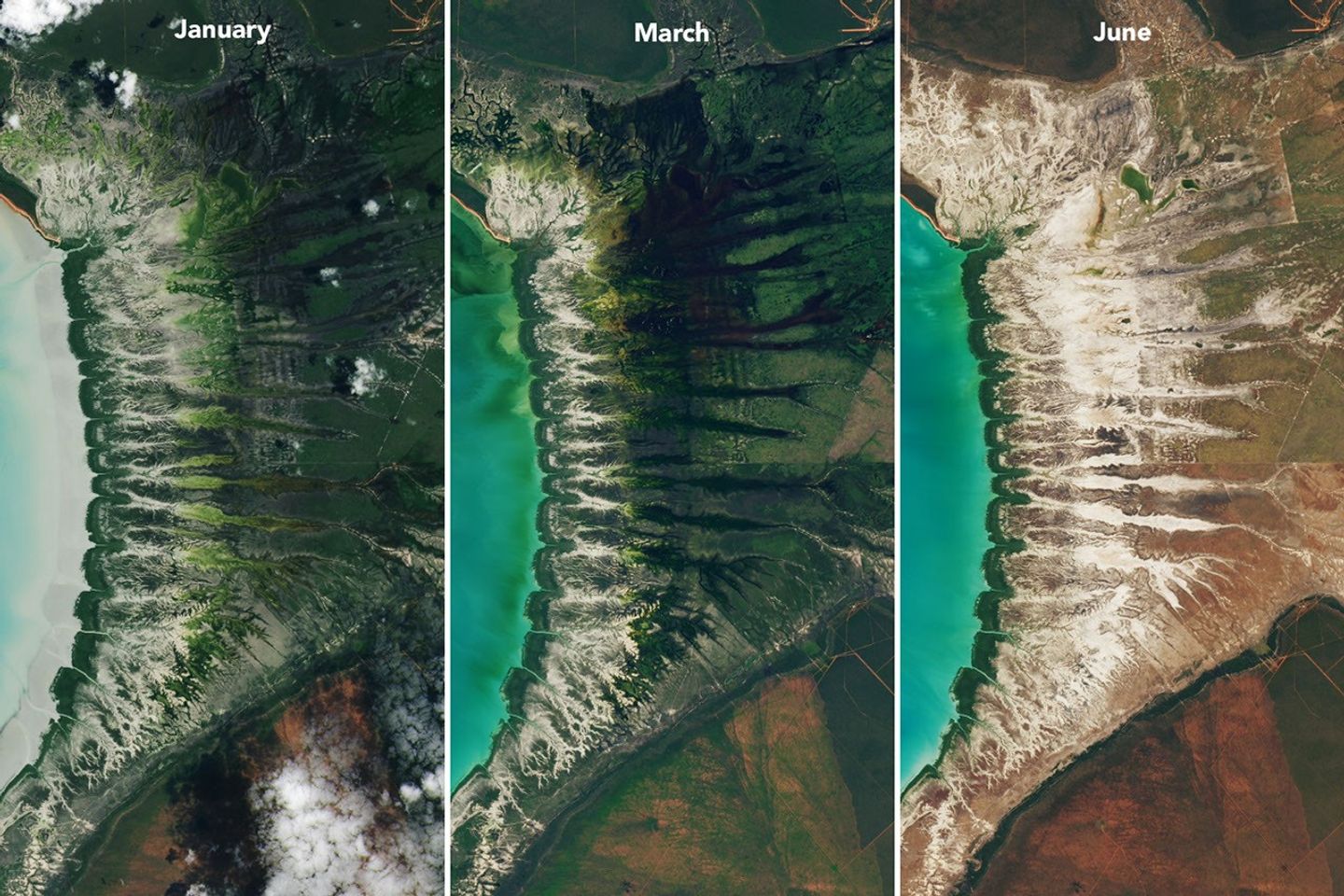
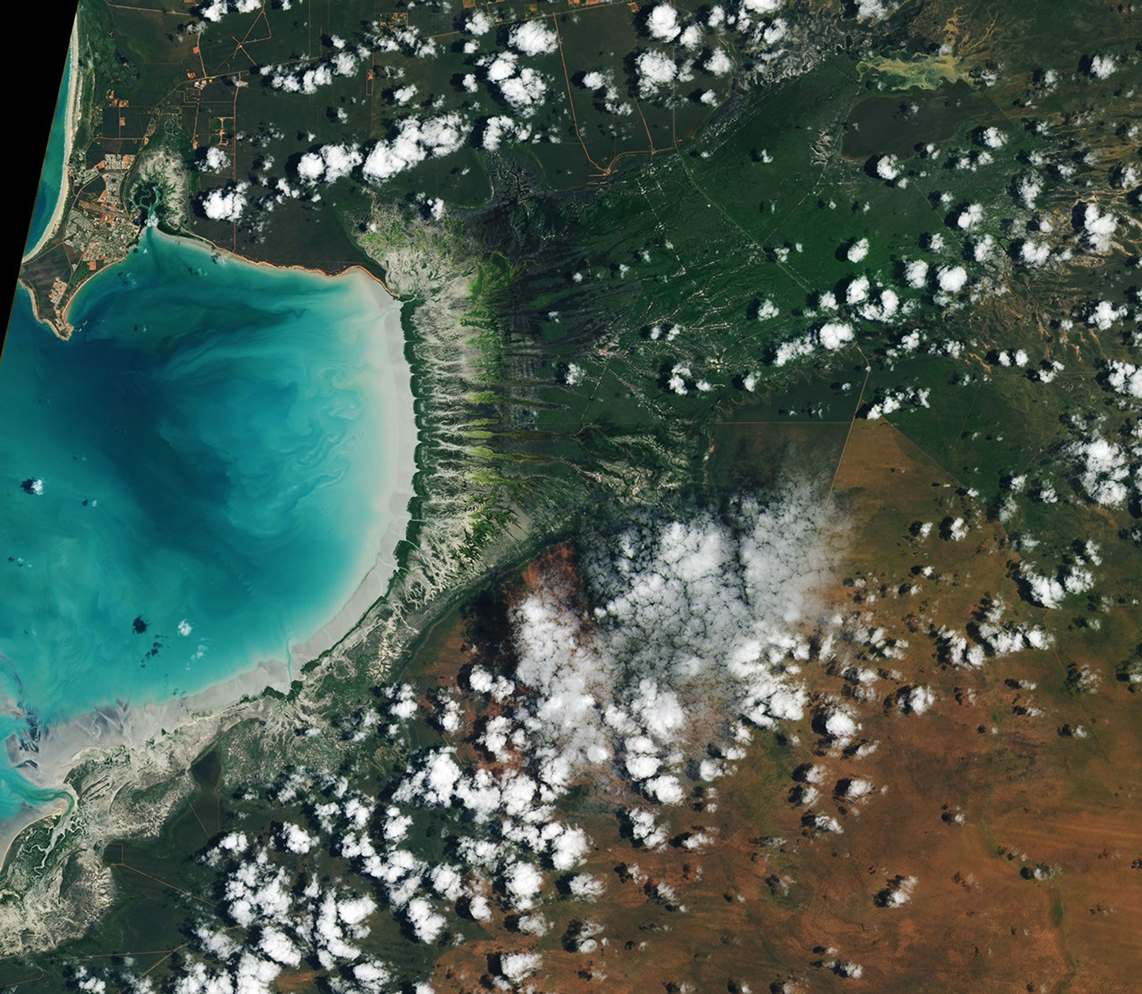
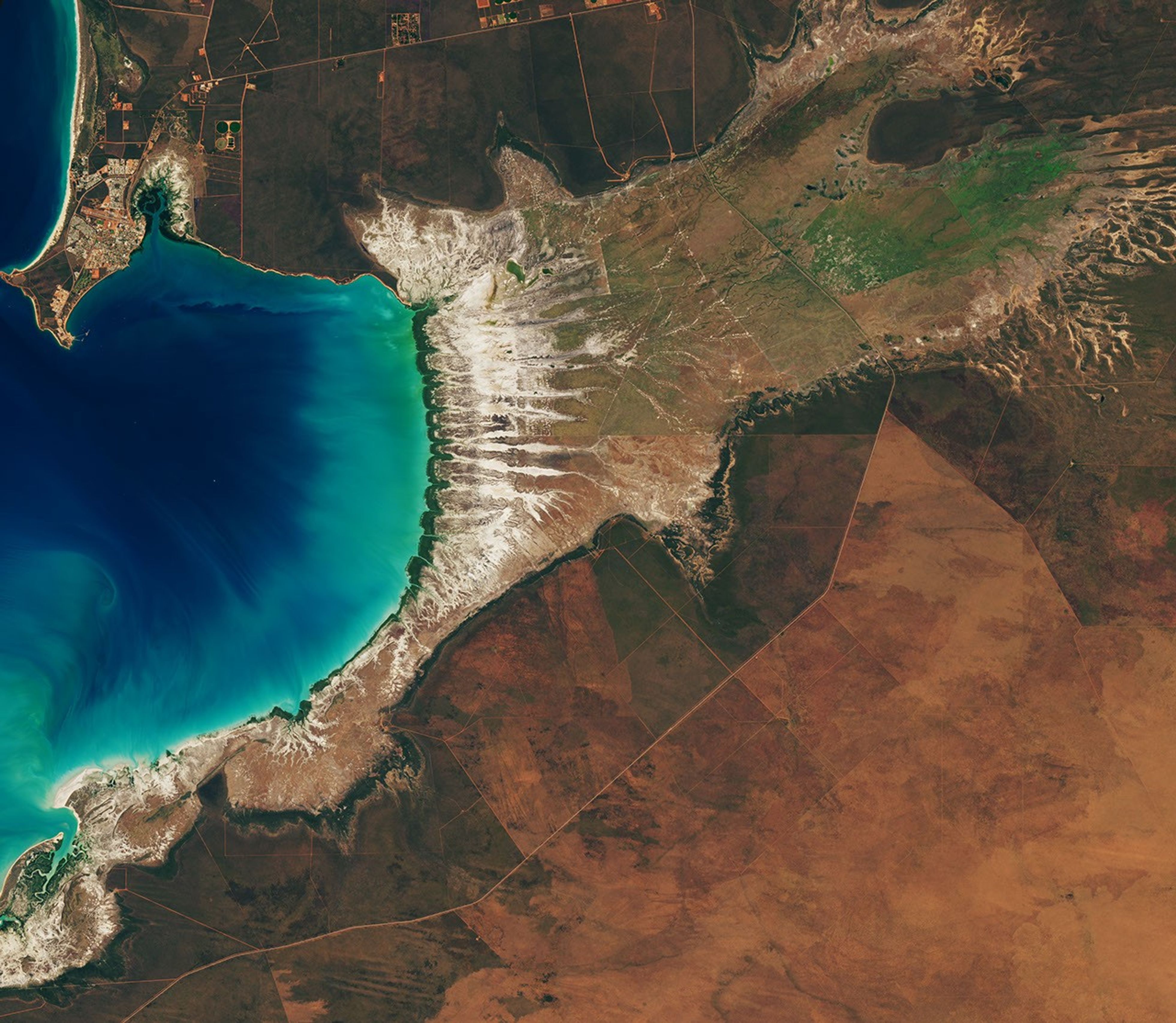
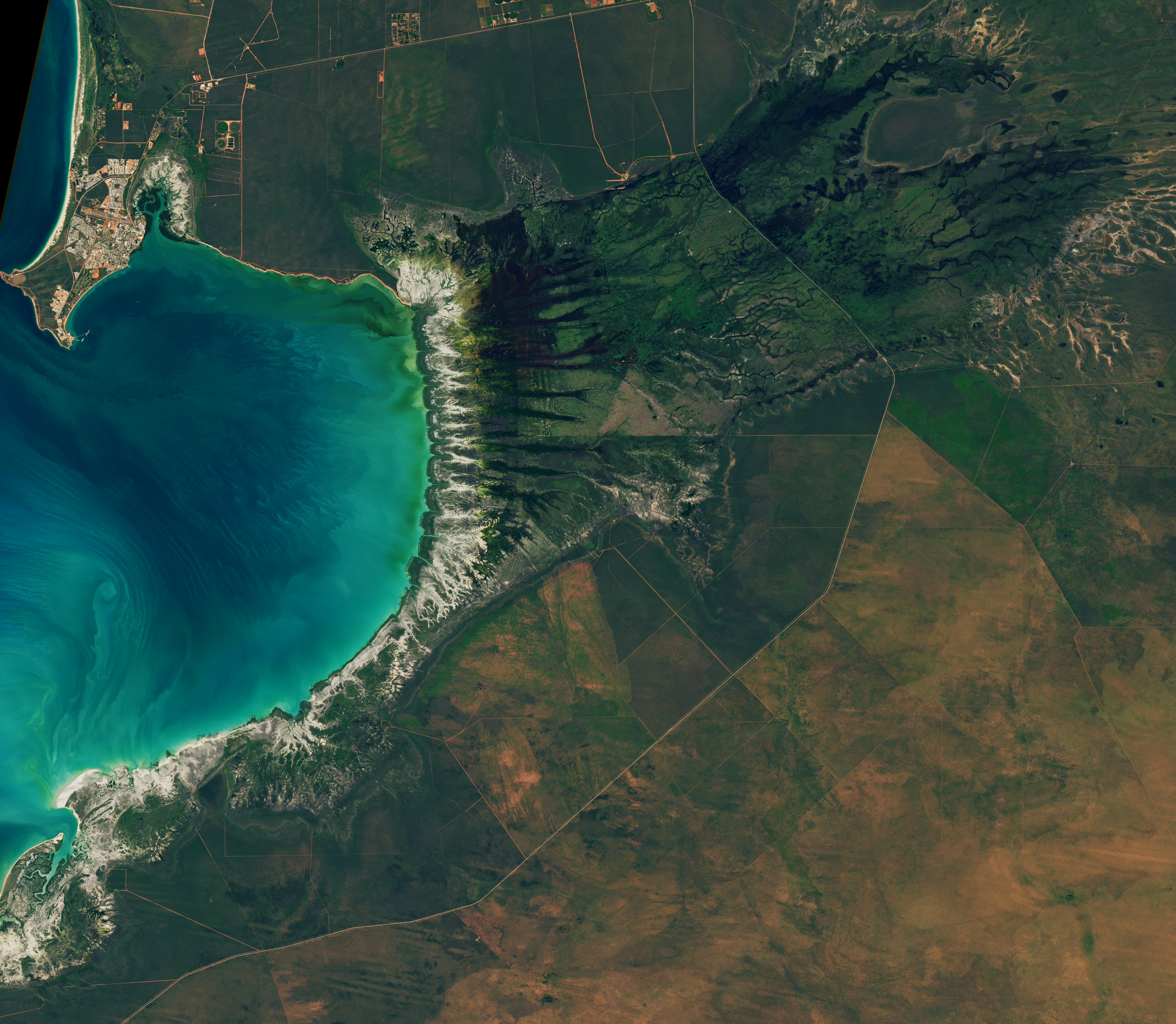
Landsat images from January 29 (left), March 18 (center), and June 30 (right) show seasonal changes. The tide was lower in the January image, exposing tan mudflats along the shoreline.
Around Roebuck Bay, inland vegetation greens after monsoon rains, peaking in March, and turns brown and dry by June. The Landsat 8 and 9 satellites captured these images throughout 2026.
NASA Earth Observatory / Lauren Dauphin

Monsoonal rains, typically falling between December and March, transform the landscape around the bay into lush grasslands and seasonal wetlands. As the rains fade in May and June and the dry season takes hold, these ephemeral grasses and sedge ecosystems die back, turning the landscape shades of gold and brown. The consistent spacing of the tidal creeks is likely not a tidal effect; it appears to be influenced by the regular spacing of linear dunes in the broader region, as seen in the plains to the east.

The bay’s dramatic tidal and seasonal changes are striking from above, and they also support a bounty of life on the ground. The mangroves serve as nurseries for crustaceans and fish, and the mudflats teem with dozens of types of invertebrates, including snails, worms, crabs, clams, and cockles. Shells and snails can reach an abundance of 2,500 per square meter, according to the Australian government.

This bounty of marine life is a major draw for birds. The bay, one of the most important sites for migratory birds in Australia and a key stop on the East Asian-Australasian Flyway, regularly hosts hundreds of thousands of birds, including plovers, godwits, and knots.

NASA Earth Observatory images by Lauren Dauphin, using Landsat data from the U.S. Geological Survey. Story by Adam Voiland.

Downloads

Tidal and seasonal shifts leave their mark on this crescent-shaped, productive bay in Western Australia's Kimberley region.

January 29, 2026

JPEG (3.65 MB)

Tidal and seasonal shifts leave their mark on this crescent-shaped, productive bay in Western Australia's Kimberley region.

March 18, 2026

JPEG (3.41 MB)

Tidal and seasonal shifts leave their mark on this crescent-shaped, productive bay in Western Australia's Kimberley region.

June 20, 2026

JPEG (3.61 MB)

References & Resources

You may also be interested in:

Stay up-to-date with the latest content from NASA as we explore the universe and discover more about our home planet.

Contours of the James Bay Lowlands

3 min read

After the Laurentide Ice Sheet retreated from present-day Hudson Bay, rebounding land has revealed striking nearshore topography.

Article

Why Maine’s Sandy Shorelines Turn Jagged

4 min read

Differences in the underlying bedrock and how rivers distribute sediment make the coastlines west of Portland look unlike those northeast…

Article

San Francisco’s Metropolitan Mosaic

3 min read

Urban development, green spaces, and maritime activity converge in this Northern California city.

Article
  •  

Community College Instructors Bring Astronomy Textbook Into 21st Century

2 min read

Community College Instructors Bring Astronomy Textbook Into 21st Century

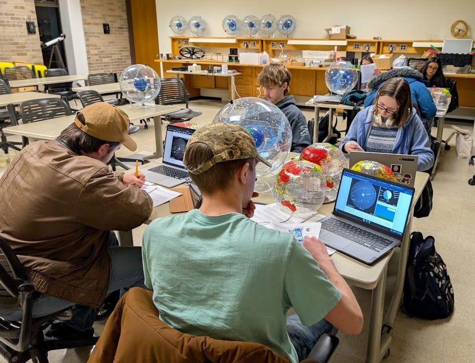
Classroom with seven students sitting at desks. They have their laptops open showing images of the celestial sphere. On the desks between the students are Earth globes and model celestial spheres.
Students studying the celestial sphere at Jackson College, Michigan.
Credit: Steven Tuckey

Teaching the beautiful and inspirational science of astronomy using only the conceptual framework offered by a traditional textbook – without incorporating the wealth of incredible resources, images and activities from NASA – falls short of the more modern, active learning experience that could better serve students evolving learning strategies. Three project teams from the NASA Science Activation (SciAct) program – NASA Community College Network (NCCN, led by the SETI Institute) and five of their expert community college instructors; Infiniscope (led by Arizona State University, ASU); and NASA Treks – set out to address this challenge. 

In June 2026, these teams gathered for a virtual workshop to lay the groundwork for incorporating active learning components drawn from NASA’s extensive education and visualization resource pool and the widely used but traditionally structured OpenStax Astronomy 101 textbook into Relevant Engaging Active Learning (REAL) courseware for introductory Astronomy, while preserving the core content and clear explanatory narrative of the text. 

Over the following two weeks, the instructors each adopted one of the opening five chapters of OpenStax, enhancing the content with active learning modules with an emphasis on materials developed by SciAct project teams, such as NASA Treks, Universe of Learning, and Cosmic Data Stories, to name a few. The results of their efforts were presented in a wrap-up presentation in July and will be field-tested in community college classrooms in Fall 2026.

This workshop served as a proof of concept for exploring whether an existing textbook can be effectively adapted into an active learning tool that will enhance students’ understanding of fundamental astronomical concepts. Next steps will include expanding the program and diving back into OpenStax to systematically reimagine the material into an active learning tool that covers the entire book – and therefore, the entire Universe! Importantly, this effort highlights new and highly impactful possibilities for the dissemination of NASA SciAct resources.

Special thanks to the five community college instructors and their invaluable wisdom, experience, and skills: Carver Bierson (Scottsdale Community College, Scottsdale Arizona), Dan Chase (Modesto Community College, Modesto, California), Dennis Just (Pima Community College, Pima, Arizona), Steve Tuckey (Jackson College, Jackson, Michigan) and Sally Watt (Glendale Community College, Glendale, Arizona).

NCCN, Infiniscope, NASA Treks, and many of the projects that contributed learning materials are supported by NASA cooperative agreement awards and are part of the NASA Science Activation Program portfolio, which connects learners with authentic NASA science experiences through partnerships with educators and community organizations.

Share

Details

Last Updated
Aug 10, 2026
Editor
NASA Science Editorial Team
  •  

NASA+ Debuts on discovery+, Coming Soon to HBO Max

Credit: NASA

As NASA+ continues its expansion across multiple streaming platforms to bring space closer to home, NASA announced Monday programming is next heading to discovery+ and HBO Max. A continuous live feed of NASA+ programming is streaming on discovery+ live channels, while HBO Max will stream NASA’s special events, including the Artemis III mission in 2027.

Viewers on those platforms can stream NASA+ content in Dolby Vision on supported devices, which will bring space exploration to life with vivid colors, sharper contrast, brighter imagery, and richer detail. This enhanced streaming experience will help viewers experience space coverage in a uniquely immersive way.

Future programming may include science mission launches, a test flight for rendezvous and docking with human landing systems, robotic lunar deliveries, the first crewed mission to the Moon under Artemis, and more. As always, NASA+ also remains available for free, with no ads, through the NASA app and on the agency’s website.

“The National Aeronautics and Space Act of 1958 calls on us to share our story of space exploration with the broadest possible audience and we continue to honor that commitment,” said Rebecca Sirmons, general manager of NASA+ at the agency’s Headquarters in Washington. “Artemis II captured the hearts and minds of viewers globally, inspiring the Artemis generation. As we return to the Moon to stay, our goal is to provide transparent, engaging content coverage every step of the way.”

Earlier this year during its Ignition event, NASA shared plans for a bold path forward for the agency, including increasing its cadence of Artemis missions to the lunar surface, and building the first Moon Base, among other agency priorities. These continuous streaming agreements strengthen NASA’s promise to public engagement, making the agency’s mission and educational content available on multiple devices for viewers on their preferred channels

For more about NASA’s missions, visit:

https://www.nasa.gov

-end-

Jennifer Dooren / Lauren Low
Headquarters, Washington
202-358-1600
jennifer.m.dooren@nasa.gov / lauren.e.low@nasa.gov

Share

Details

Last Updated
Aug 10, 2026
  •  

Lion Nebula Roars to Life With NASA’s Webb

 
4 Min Read

Lion Nebula Roars to Life With NASA’s Webb

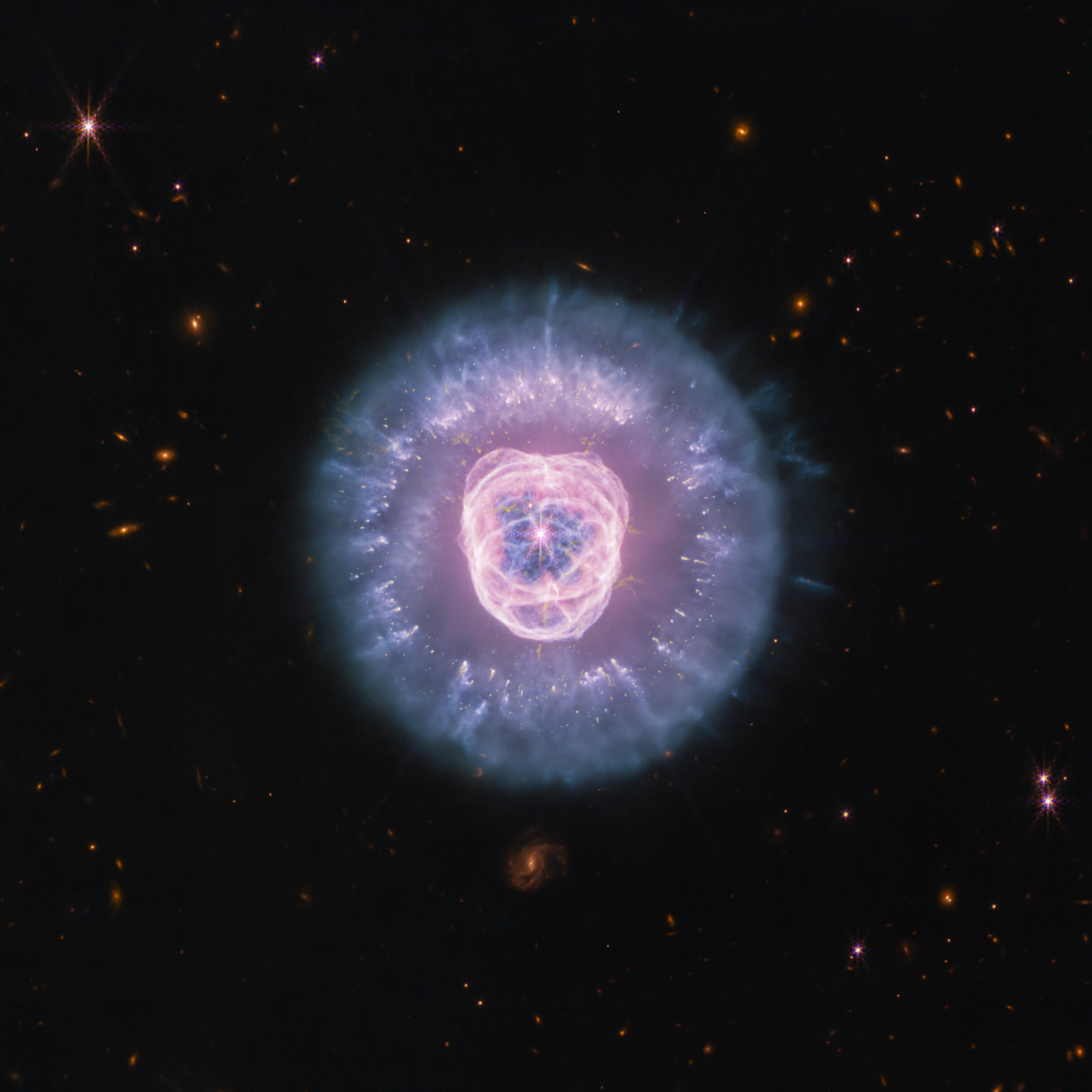
JWST’s Near Infrared Camera and Mid Infrared Instrument combined image of planetary nebula NGC 2392, the Lion Nebula, against the black background of space. The nebula is at center, circular in shape, and looks like a male lion’s head. In the center is a small, pinkish-white circle with eight-point diffraction spikes, a white dwarf star. Surrounding the star are purple-pink cavernous bubbles and shell-like rings. The bubbles and shells collectively form an oval with two small, wide arcs near the top, reminiscent of a lion’s face and its ears. What appears to be extended outward from the lion’s face is a thick ring of purple-blue material. The width of the ring is consistent throughout and resembles a mane. The area closest to the lion’s face looks cloudy, while the edges of the mane look like there are clumps of dust with comet-like tails. In the background are distant galaxies and stars. Some galaxies are yellow and orange points of light and others have spiral structures. Some stars have diffraction spikes.
NASA’s James Webb Space Telescope imaged the planetary nebula NGC 2392, the Lion Nebula, using the observatory’s NIRCam and MIRI instruments. The central star’s remains are responsible for the nebula’s structure, including a lion face-shaped bubble of ionized gas and dust “mane.”
Credits:
Image: NASA, ESA, CSA, STScI; Image Processing: Alyssa Pagan (STScI)

Observing across the starry “plains” of space, NASA’s James Webb Space Telescope has taken new images of NGC 2392, nicknamed the Lion Nebula. NASA’s Hubble Space Telescope previously viewed this planetary nebula in 2000, imaging the lion face-shaped target in visible light and revealing features such as the “mane” of hazy, comet-shaped objects. Now Webb has captured a clearer, more detailed view of the Lion Nebula due to its high-resolution imaging.

Lion Nebula (NIRCam and MIRI Image)

JWSTu2019s Near Infrared Camera and Mid Infrared Instrument combined image of planetary nebula NGC 2392, the Lion Nebula, against the black background of space. The nebula is at center, circular in shape, and looks like a male lionu2019s head. In the center is a small, pinkish-white circle with eight-point diffraction spikes, a white dwarf star. Surrounding the star are purple-pink cavernous bubbles and shell-like rings. The bubbles and shells collectively form an oval with two small, wide arcs near the top, reminiscent of a lionu2019s face and its ears. What appears to be extended outward from the lionu2019s face is a thick ring of purple-blue material. The width of the ring is consistent throughout and resembles a mane. The area closest to the lionu2019s face looks cloudy, while the edges of the mane look like there are clumps of dust with comet-like tails. In the background are distant galaxies and stars. Some galaxies are yellow and orange points of light and others have spiral structures. Some stars have diffraction spikes.
NASA’s James Webb Space Telescope imaged the planetary nebula NGC 2392, the Lion Nebula, using the observatory’s NIRCam and MIRI instruments. The central star’s remains are responsible for the nebula’s structure, including a lion face-shaped bubble of ionized gas and dust “mane.”
Image: NASA, ESA, CSA, STScI; Image Processing: Alyssa Pagan (STScI)

At first glance the nebula’s overall structure in Webb’s infrared images, with both the NIRCam (Near Infrared Camera) and MIRI (Mid Infrared Instrument) instruments, may look quite similar to Hubble’s earlier visible-light view. However, Webb’s infrared vision highlights features like compact clumps of dust and a haze of ionized gas. It’s taken several thousand years for this collection of gas and dust to reach its current shape, and the nebula’s components continue to be altered.

The source of these constant changes and the reason for the Lion Nebula’s distinct appearance is located at the center: the remains of a dying star. Though it looks like the button nose of the lion, its energy and radiation are powering the intricate structures seen here.

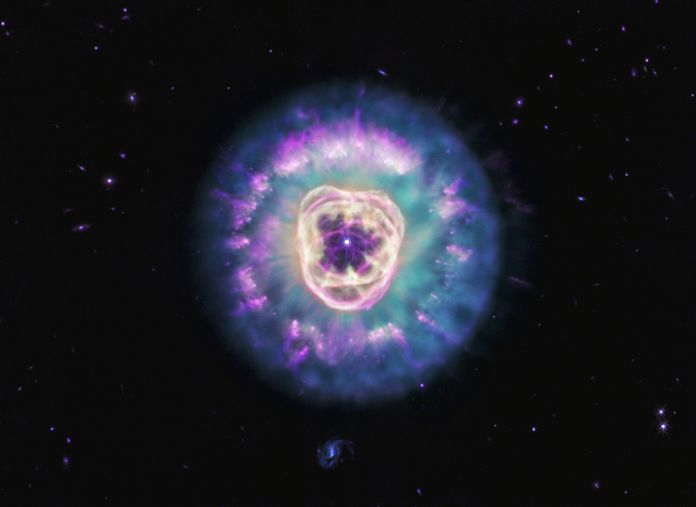
Lion Nebula (MIRI Image)

Planetary nebula NGC 2392, also called the Lion Nebula, against the black background of space. The nebula is in the center, circular in shape, and looks like a male lion’s head. In the very center is a small, bluish-white circle with eight-point diffraction spikes, a white dwarf star. Surrounding the star are light purple-red cavernous bubbles and shell-like rings. The bubbles and shells collectively form an oval with two small, wide arcs near the top, reminiscent of a lion’s face and its ears. What appears to be extended outward from the lion’s face is a thick ring of cyan material. The width of the ring is consistent throughout and resembles a mane. The area closest to the lion’s face looks cloudy, while the edges of the mane look like there are purple clumps of dust with comet-like tails and strands. In the background are distant galaxies and stars. Some galaxies appear as small purple points of light and others with visible blue spiral structures. A couple of the stars have diffraction spikes.
NASA’s James Webb Space Telescope’s mid-infrared image of planetary nebula NGC 2392, nicknamed the Lion Nebula, highlights the varying dust structures. Some dust is being destroyed by the dying central star’s radiation, while some dust filaments manage to survive.
Image: NASA, ESA, CSA, STScI; Image Processing: Alyssa Pagan (STScI)

Massive stars undergo supernova explosions at the end of their lives, but these kinds of events are few and far in between. Most of the universe’s stars have lower masses, like the one belonging to NGC 2392. When a lower-mass star can no longer sustain itself with nuclear reactions in its core, the star becomes unstable and pulsates, losing its mass by shedding its outer layers, which then turn into shells of gas and dust called a planetary nebula. (Stars at this life stage are responsible for producing much of the universe’s observable dust.) The star’s radiation drives the ejected material away, leaving behind the very hot stellar core, also known as a white dwarf.

In the Lion Nebula’s case, the death of the oxygen-rich central star has left behind a white dwarf that is “cooking” everything from the inside and producing a bubble of ionized gas as it does. The gas bubble, which forms the lion’s face, is expanding over time and destroying dust that is in its path. Understanding why the swept-up gas has a complex structure of rings and shells, a common feature in planetary nebulae, is an ongoing endeavor.

The mane of the lion is the interior of a dust shell that is being illuminated by the white dwarf at the center. The tufts of hair, which look like cometary tails of material, are compact clumps of dust that have survived the stellar core’s radiation and protect the material that lies behind them.

Webb’s imagery “freezes” this planetary nebula in time, though the star’s death, and its tumultuous effects, go on. NGC 2392 will continue to undergo changes as its gas and dust migrate away from the stellar core. Astronomers estimate the lion will eventually disperse in approximately 10,000 years — a relatively short period in astronomical terms.

The James Webb Space Telescope is the world’s premier space science observatory. Webb is solving mysteries in our solar system, looking beyond to distant worlds around other stars, and probing the mysterious structures and origins of our universe and our place in it. Webb is an international program led by NASA with its partners, ESA (European Space Agency) and CSA (Canadian Space Agency).

To learn more about Webb, visit:

https://science.nasa.gov/webb

Downloads & Related Information

The following sections contain links to download this article’s images and videos in all available resolutions followed by related information links, media contacts, and if available, research paper and Spanish translation links.

Related Images & Videos

JWSTu2019s Near Infrared Camera and Mid Infrared Instrument combined image of planetary nebula NGC 2392, the Lion Nebula, against the black background of space. The nebula is at center, circular in shape, and looks like a male lionu2019s head. In the center is a small, pinkish-white circle with eight-point diffraction spikes, a white dwarf star. Surrounding the star are purple-pink cavernous bubbles and shell-like rings. The bubbles and shells collectively form an oval with two small, wide arcs near the top, reminiscent of a lionu2019s face and its ears. What appears to be extended outward from the lionu2019s face is a thick ring of purple-blue material. The width of the ring is consistent throughout and resembles a mane. The area closest to the lionu2019s face looks cloudy, while the edges of the mane look like there are clumps of dust with comet-like tails. In the background are distant galaxies and stars. Some galaxies are yellow and orange points of light and others have spiral structures. Some stars have diffraction spikes.

Lion Nebula (NIRCam and MIRI Image)

NASA’s James Webb Space Telescope imaged the planetary nebula NGC 2392, the Lion Nebula, using the observatory’s NIRCam and MIRI instruments. The central star’s remains are responsible for the nebula’s structure, including a lion face-shaped bubble of ionized gas and dust “mane.”

Planetary nebula NGC 2392, also called the Lion Nebula, against the black background of space. The nebula is in the center, circular in shape, and looks like a male lionu2019s head. In the very center is a small, bluish-white circle with eight-point diffraction spikes, a white dwarf star. Surrounding the star are light purple-red cavernous bubbles and shell-like rings. The bubbles and shells collectively form an oval with two small, wide arcs near the top, reminiscent of a lionu2019s face and its ears. What appears to be extended outward from the lionu2019s face is a thick ring of cyan material. The width of the ring is consistent throughout and resembles a mane. The area closest to the lionu2019s face looks cloudy, while the edges of the mane look like there are purple clumps of dust with comet-like tails and strands. In the background are distant galaxies and stars. Some galaxies appear as small purple points of light and others with visible blue spiral structures. A couple of the stars have diffraction spikes.

Lion Nebula (MIRI Image)

NASA’s James Webb Space Telescope’s mid-infrared image of planetary nebula NGC 2392, nicknamed the Lion Nebula, highlights the varying dust structures. Some dust is being destroyed by the dying central star’s radiation, while some dust filaments manage to survive.

Related Links

Explore more: Sonification of NGC 2392

View more: Hubble Image of NGC 2392

View more: Chandra X-ray Observatory Image of NGC 2392

More Webb: News | Images | Science | Home Page


Share

Details

Last Updated
Aug 10, 2026

Contact
Media

Laura Betz
NASA’s Goddard Space Flight Center
Greenbelt, Maryland
laura.e.betz@nasa.gov

Abigail Major
Space Telescope Science Institute
Baltimore, Maryland

Christine Pulliam
Space Telescope Science Institute
Baltimore, Maryland

  •  

Launch Into a New School Year With NASA

4 Min Read

Launch Into a New School Year With NASA

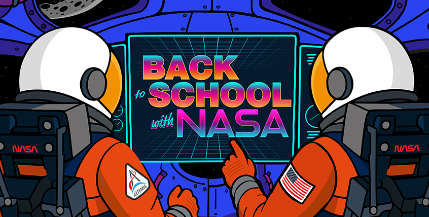
An illustration of two astronauts inside a spacecraft, looking at a screen that says "Back to School with NASA"

A new school year brings fresh opportunities to get involved with NASA. Whether you’re curious about space or eager to build real STEM skills, NASA offers a world of experiences putting you close to the action. As we enter a new golden age of exploration, there’s no better time to jump in, try something bold, and see where your curiosity takes you.

Gain Hands-On NASA Experience

NASA opens the door to authentic mission experiences through internships and student challenges. As members of the NASA team, interns work on genuine agency projects and gain industry-ready skills, all with the guidance of NASA mentors. Visit NASA’s internships website to learn more about current vacancies, deadlines, eligibility requirements, and more.

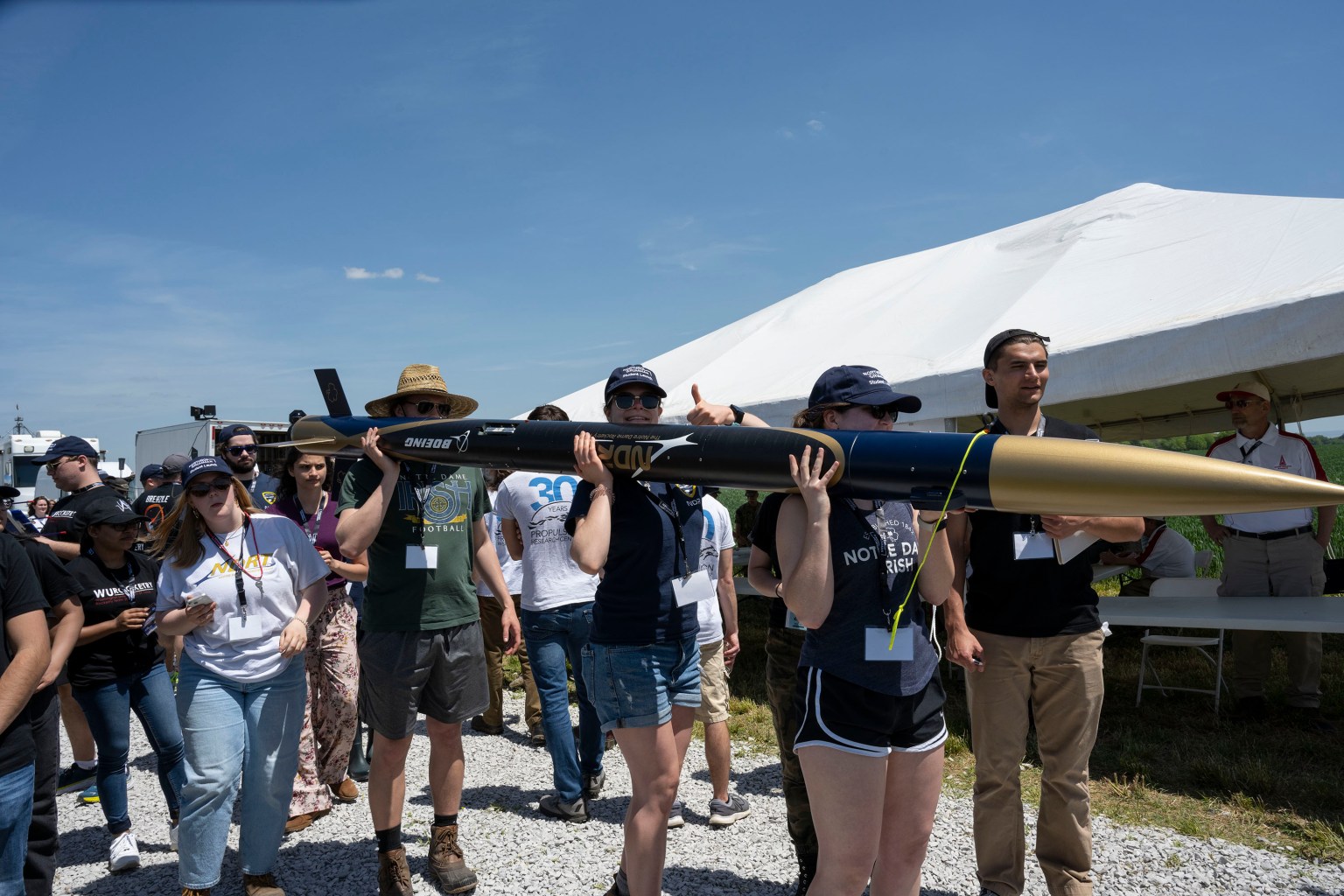
Through NASA’s student challenges and competitions, student teams tackle some of the critical technical hurdles facing mission planners. Flex your innovative muscles and sharpen your collaborative and problem-solving skills while developing, prototyping, and testing your team’s designs. Check out the full list of NASA STEM challenges and opportunities, choose one that fits your interests, and assemble your team.

More than 500 students with 75 teams from around the world participated in the 31st year of NASA’s Human Exploration Rover Challenge (HERC) on April 11 and April 12, 2025, near NASA’s Marshall Space Flight Center in Huntsville, Alabama. Participating teams represented 35 colleges and universities, 38 high schools, and two middle schools from 20 states, Puerto Rico, and 16 other nations. NASA expanded the 2025 challenge to include a remote-control division - named Remote-Operated Vehicular Research - and invited middle school students to participate. Teams were awarded points based on navigating a half-mile obstacle course, conducting mission-specific task challenges, and completing multiple safety and design reviews with NASA engineers.
Students cross the finish line in their human-powered rover during the 2025 Human Exploration Rover Challenge at NASA’s Marshall Space Flight Center in Huntsville, Alabama
USSRC/Emily Riddle

Discover Technical Careers at NASA

The future of aerospace depends on a steady pipeline of skilled technical experts ready to make missions and ideas a reality. NASA invites students in high school, community college, and career technical education programs to join in-person and virtual events to explore these important career paths.
 
NASA Career Technical Education Days bring students on-site to meet NASA skilled technical workers who share what their jobs are like, how they built their careers, and the skills, training, and certifications that have helped them succeed. During NASA’s Next Gen STEM Virtual Career Connections , students interact live with technical experts supporting the agency’s missions. Students and teachers can learn more on the Next Gen STEM for Careers website.

A technician performs welding on a spacecraft transporter at NASA’s Kennedy Space Center in Florida.
NASA/Ben Smegelsky

Contribute to NASA Science as a Citizen Scientist

NASA’s Science Mission Directorate invites you to help make real discoveries through science projects powered by volunteers. Join from anywhere, whenever it fits your schedule, and start working with authentic mission data. Help identify comets and asteroids, hunt for binary star systems, and more. Find the project that’s right for you on the list of current citizen science projects.

Keep Up With NASA Missions and Discoveries

Don’t miss out on NASA’s biggest mission milestones this school year! Up first is the Nancy Grace Roman Space Telescope, scheduled to launch no earlier than 7:20 a.m. EDT on Sunday, Aug. 30. This powerful new observatory has a field of view at least 100 times larger than the Hubble Space Telescope. Be a virtual guest for launch and learn more about the telescope with fun activities provided by NASA’s Science Mission Directorate. You can also sign up to be a virtual guest for NASA’s next crewed launch to the International Space Station, SpaceX Crew-13, set to launch in September.

And be sure to follow NASA’s continuing crew training and hardware preparations for Artemis III. Set to launch into Earth orbit in 2027, the flight will test rendezvous and docking capabilities with commercial human landing systems – landers that will carry astronauts to the lunar surface on Artemis IV and future missions to the Moon.

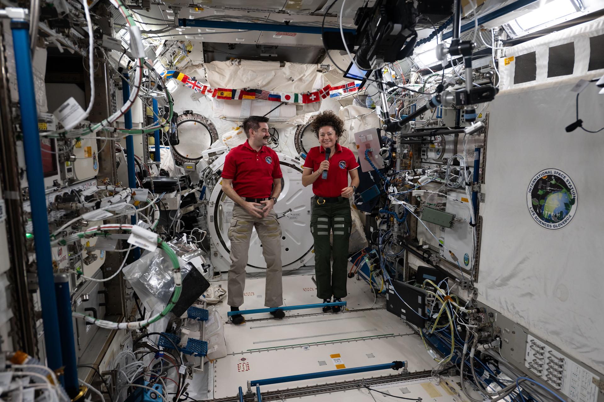
NASA astronauts Jack Hathaway and Jessica Meir, both Expedition 74 flight engineers, answer questions inside the International Space Station’s Kibo laboratory module during a live downlink event with Connecticut Public Radio. Hathaway is a native of South Windsor, Connecticut, while Meir is from Caribou, Maine.
NASA astronauts Jack Hathaway and Jessica Meir answer questions inside the International Space Station’s Kibo laboratory module during a live downlink event in May 2026.
NASA

Stay Engaged With NASA

Schools, classrooms, and community-based student groups have further options to engage with NASA and its people. Through In-Flight STEM Downlinks, students have their pre-recorded questions answered live by astronauts aboard the International Space Station, demonstrating how STEM careers reach far beyond Earth. Additionally, the NASA Engages public outreach program connects agency experts with student audiences to share mission and science updates, helping people discover how NASA’s work unfolds and how they can be part of the journey.

This school year, whether you’re interested in aerospace jobs or eager to dive into authentic STEM challenges, you’ll find an array of activities and career exploration tools on NASA’s Learning Resources website. Explore exciting NASA student opportunities and subscribe to the weekly NASA EXPRESS email newsletter for the latest NASA STEM opportunities and updates!

  •  

APOD: 2026 August 10 – Three Galaxy Pairs

APOD

APOD: 2026 August 10 – Three Galaxy Pairs

Discover the cosmos! Each day a different image or photograph of our fascinating universe is featured, along with a brief explanation written by a professional astronomer.

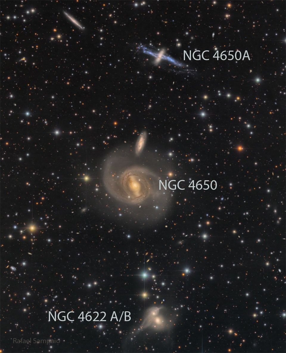
Three galaxy pairs are arranged vertically in the same field of view..Three galaxy pairs are arranged vertically in the same field of view..

Three Galaxy Pairs

Explanation: Each of these pairs of galaxies is different. The two galaxies at the top are likely not interacting, at least presently. However, the top galaxy with the blue stripe, NGC 4650A, is a polar ring galaxy and may be the result of a past galaxy collision. The two galaxies in the middle of the featured image appear like they could be interacting gravitationally — but their relative speeds make this unlikely. Of these two, the larger galaxy, NGC 4650, is a spiral galaxy with a bright bar of stars across its center. The two galaxies at the bottom are actively interacting. Possibly in a billion years or so, NGC 4622A and NGC 4622B will merge and become one single galaxy. All of these galaxies are likely members of the larger Centaurus Galaxy Cluster.

Tomorrow’s picture: many moons

Date: August 10, 2026
Credit & Copyright: Rafael Sampaio
Authors & editors: Robert Nemiroff, Jerry Bonnell, Cecilia Chirenti, Keighley Rockcliffe
A service of: ASD at NASA / GSFC,
NASA Science Activation & Michigan Tech. U.
  •  

El Niño Alters Marine Life in the Pacific


june 2025
june 2026

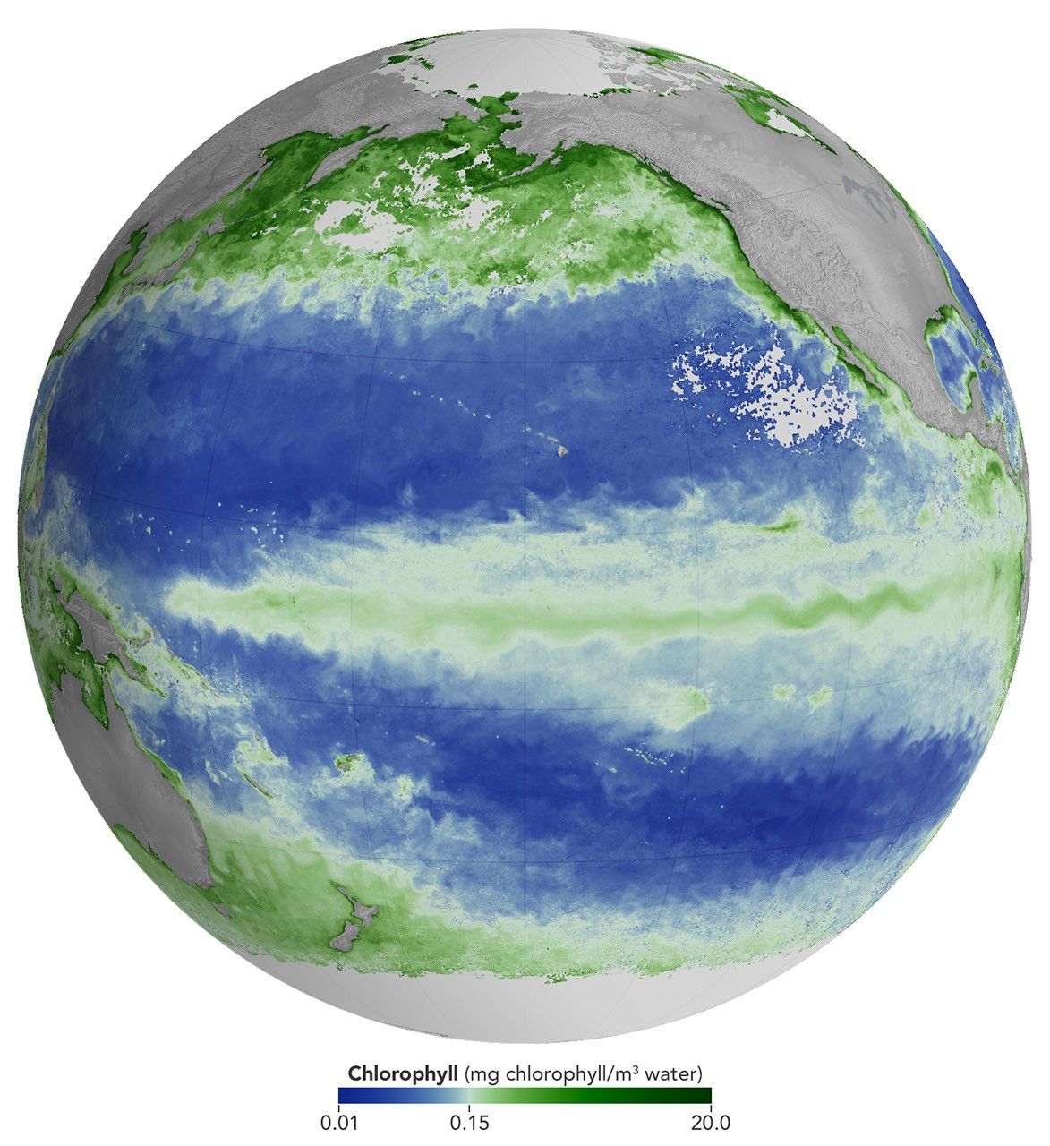
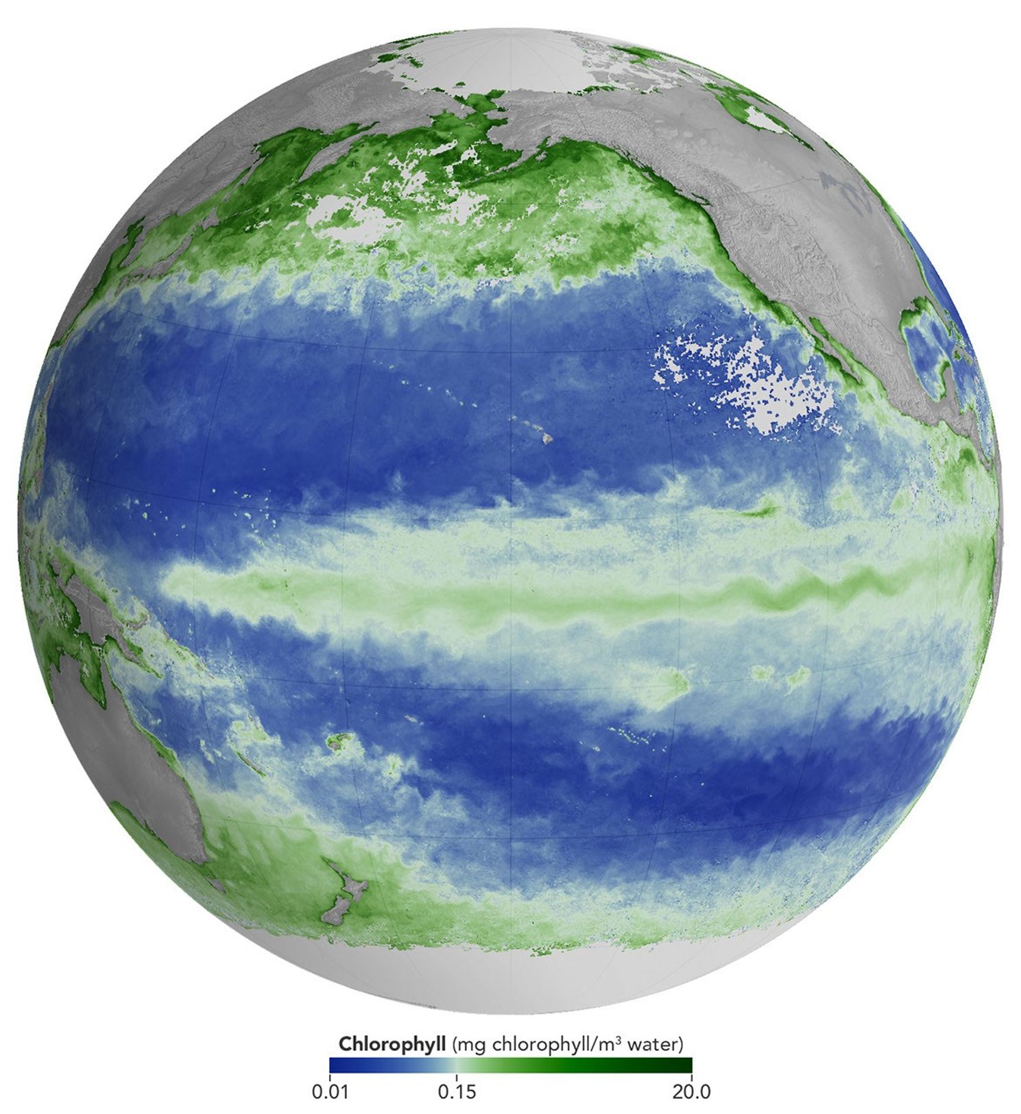
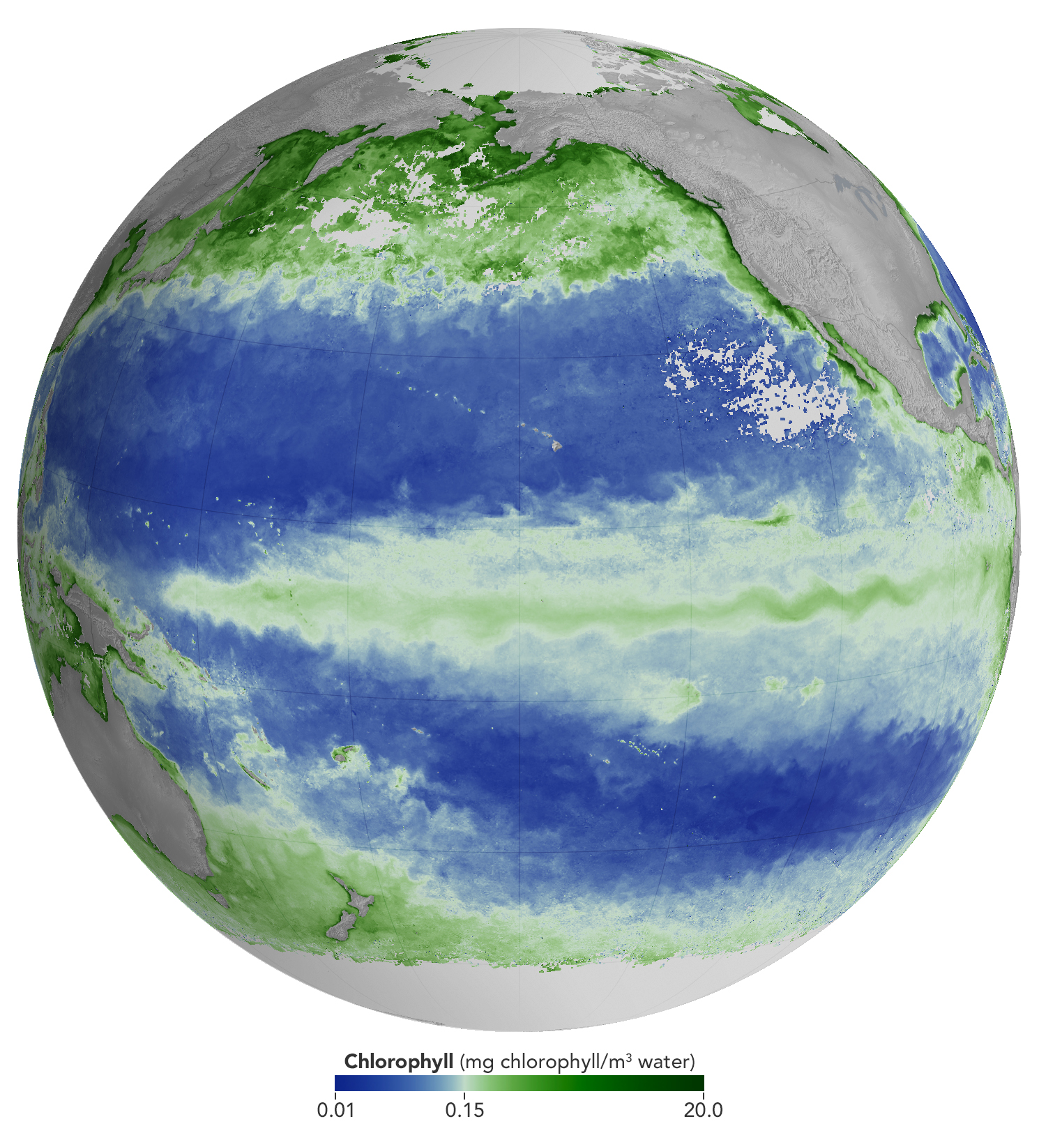
A global map centered on the Pacific Ocean shows a band of green across the equatorial region, indicating the presence of chlorophyll in surface waters.
NASA Earth Observatory/Michala Garrison

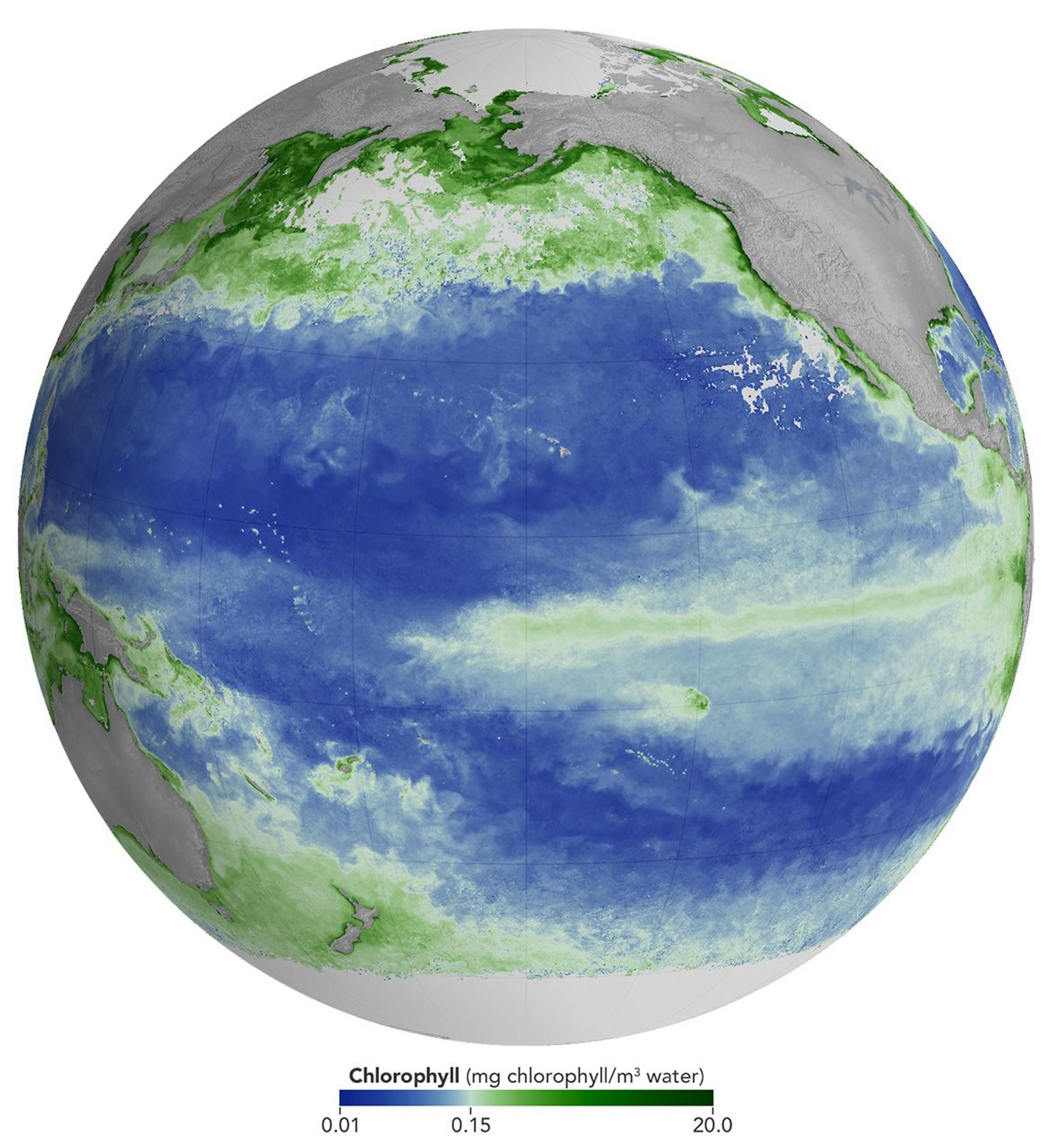
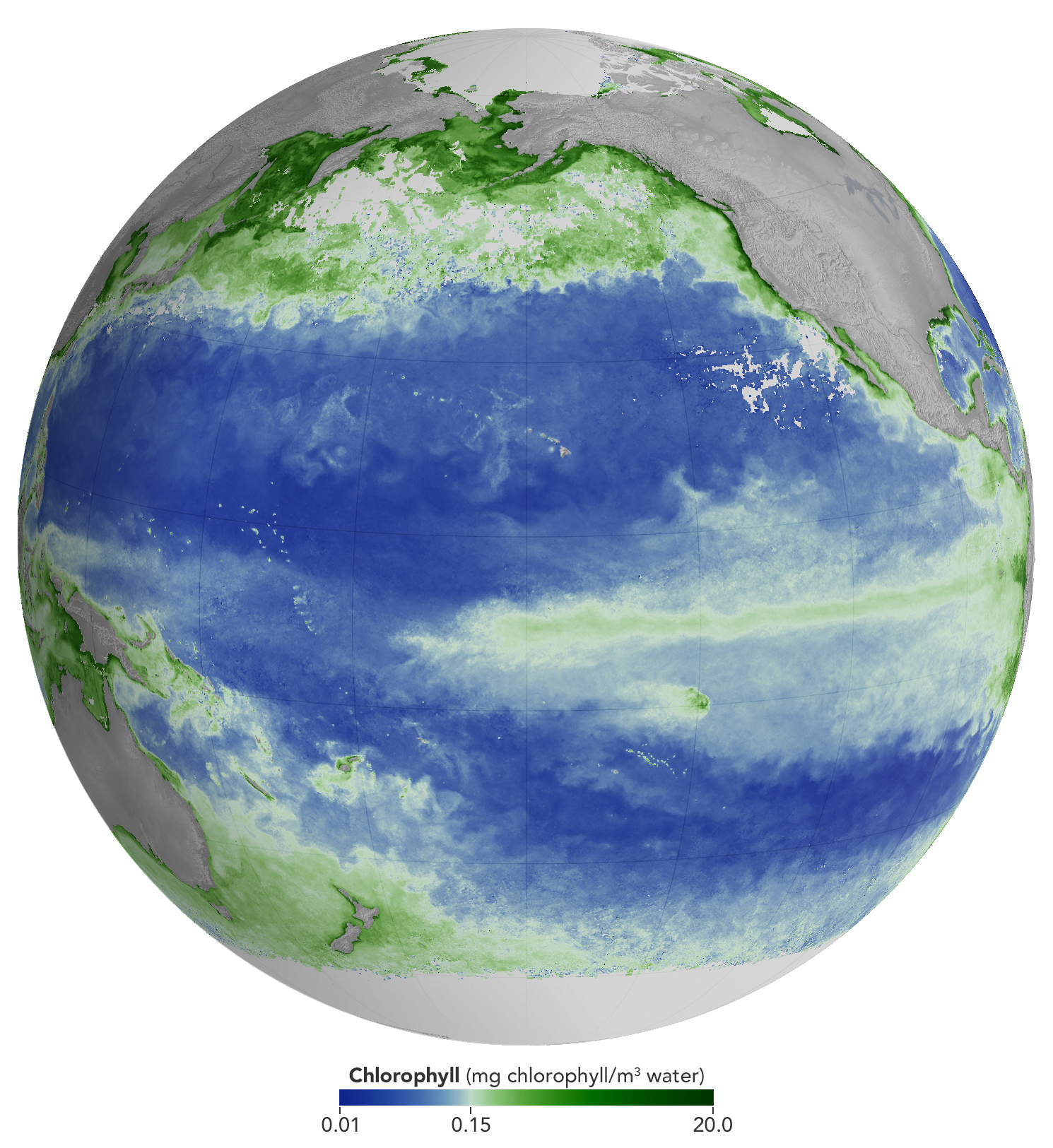
A global map centered on the Pacific Ocean shows a narrow band of green in the eastern equatorial region, indicating the presence of chlorophyll in surface waters. The central equatorial Pacific appears blue, meaning chlorophyll concentrations are low.
NASA Earth Observatory/Michala Garrison

A global map centered on the Pacific Ocean shows a band of green across the equatorial region, indicating the presence of chlorophyll in surface waters.
NASA Earth Observatory/Michala Garrison
A global map centered on the Pacific Ocean shows a narrow band of green in the eastern equatorial region, indicating the presence of chlorophyll in surface waters. The central equatorial Pacific appears blue, meaning chlorophyll concentrations are low.
NASA Earth Observatory/Michala Garrison

june 2025

june 2026


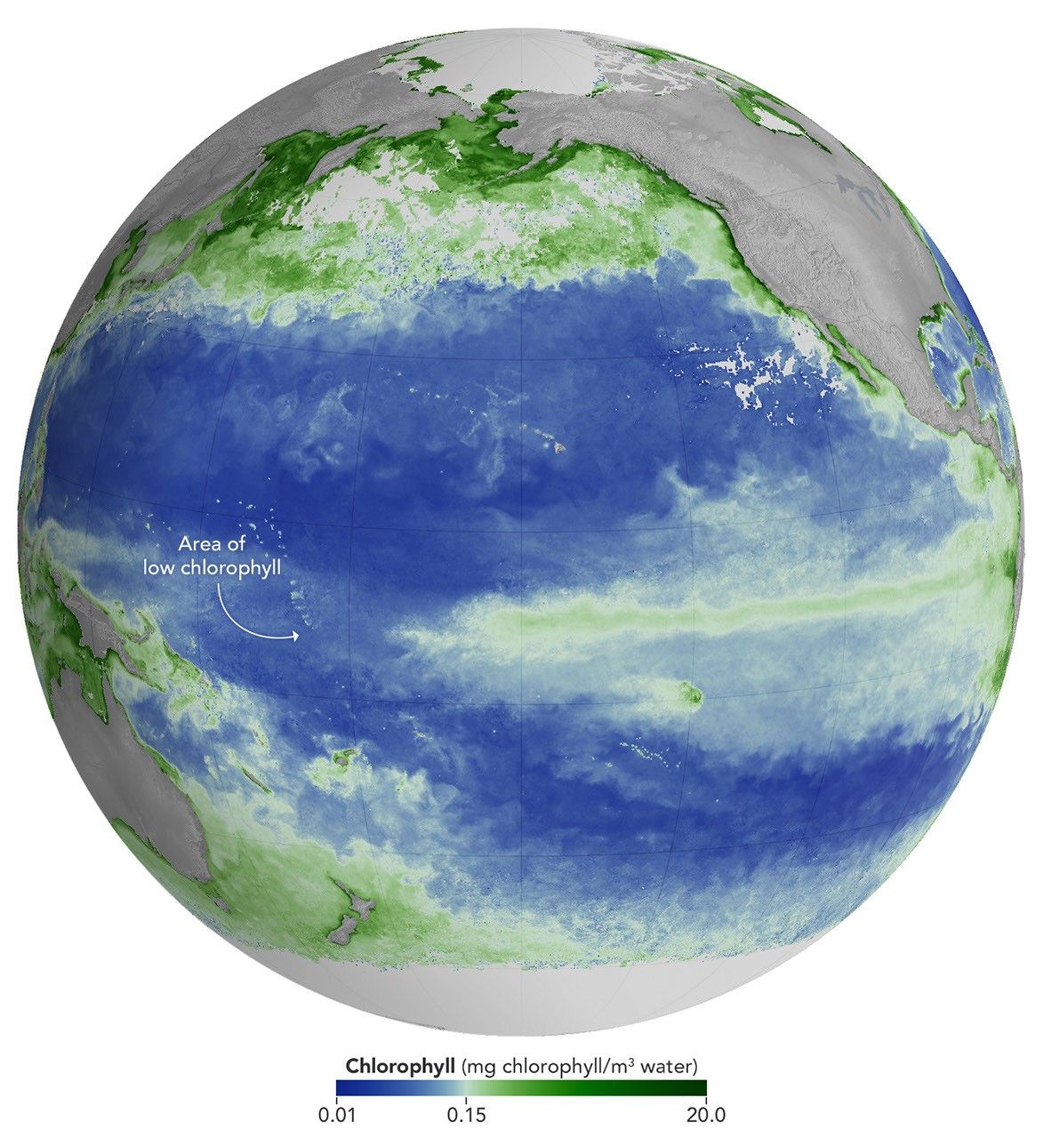
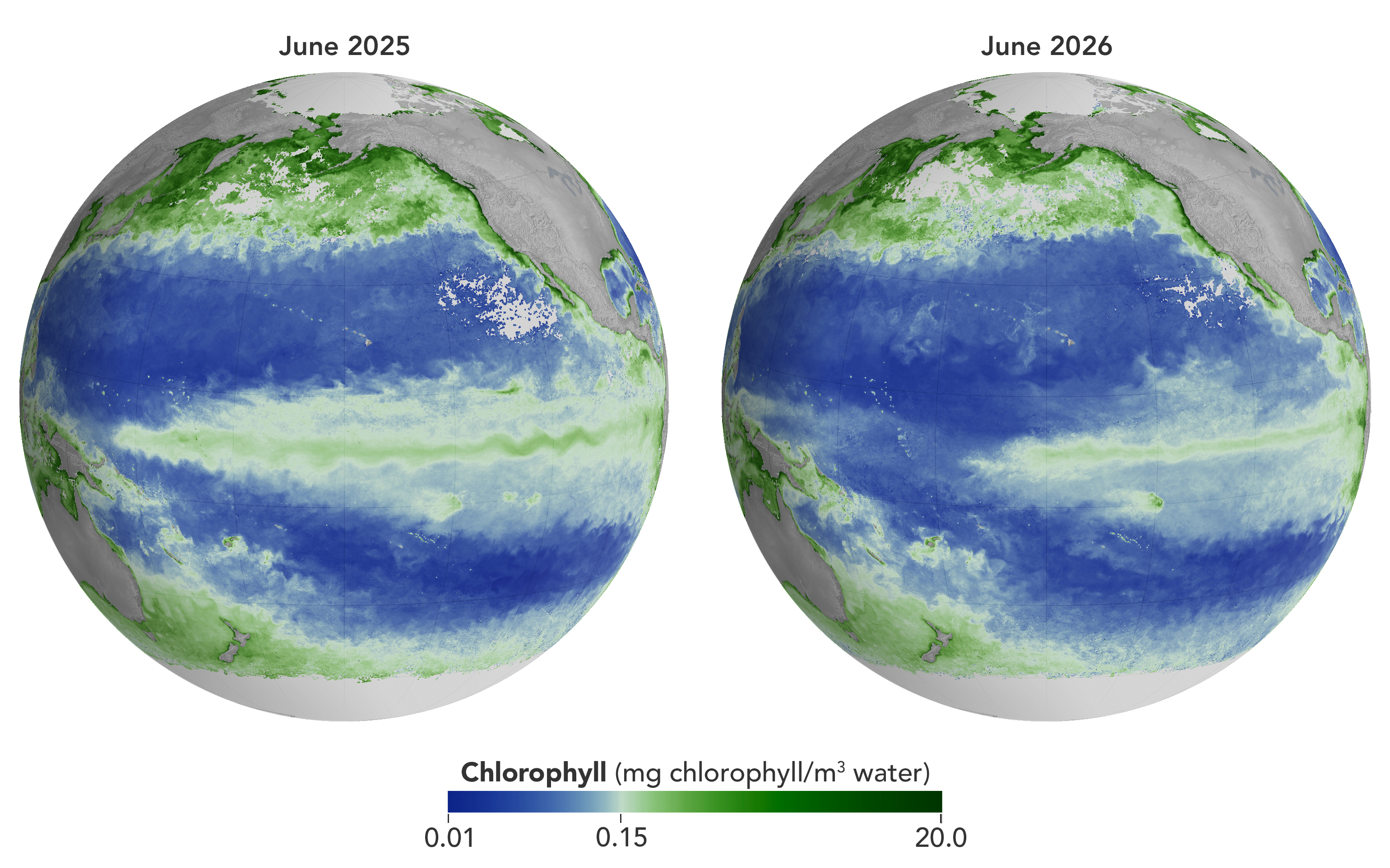
Concentrations of chlorophyll in the equatorial Pacific deviate from normal during El Niño events. These maps depict monthly average chlorophyll concentrations for June 2025 (left), under neutral conditions, and June 2026 (right), as El Niño was strengthening. Data come from the OCI (Ocean Color Instrument) on NASA’s PACE (Plankton, Aerosol, Cloud, ocean Ecosystem) satellite and are based on measurements of green and blue light from the ocean reflected back to the sensor. NASA Earth Observatory images by Michala Garrison.

As of June 2026, El Niño has officially arrived. This naturally recurring phenomenon is characterized by warmer-than-normal water temperatures in parts of the equatorial Pacific along with changes to atmospheric and oceanic circulation patterns. Its regional effects range from desert floods to delayed monsoons to shifts in where tropical cyclones are more likely to form.

NOAA’s Climate Prediction Center expects the current El Niño to continue to strengthen through the end of 2026, with a 97 percent chance of lasting through early Northern Hemisphere spring 2027. Even during El Niño’s early stages, satellites have observed characteristic changes along the equatorial Pacific, such as warmer-than-normal sea surface temperatures and higher-than-normal sea surface height.

Among the first ecological downstream effects are changes to the marine food web. The maps above show chlorophyll-a concentrations—the pigment present in most phytoplankton—as observed by the OCI (Ocean Color Instrument) on NASA’s PACE (Plankton, Aerosol, Cloud, ocean Ecosystem) satellite. In June 2025 (left), conditions were neutral, while in June 2026 (right), El Niño was strengthening.

The most noticeable difference appears in the central Pacific, around the equator due north of New Zealand: chlorophyll concentrations, an indication of phytoplankton abundance, are substantially lower in 2026. This change is expected, said Matthew Kehrli and Graham Trolley, oceanographers in the Ocean Ecology Laboratory at NASA’s Goddard Space Flight Center. That’s because during an El Niño, easterly equatorial trade winds weaken, the warm surface layer of the ocean extends deeper, and the upwelling of cool, nutrient-rich water that typically fuels phytoplankton growth is suppressed.  

As the El Niño progresses, the scientists anticipate the differences in the central Pacific will become more pronounced. “This may manifest as a greater difference in values across the current region, as a broadening region of reduced surface chlorophyll-a concentration, or both, depending on the behavior of the equatorial trade winds,” they said.

Reductions in phytoplankton have ripple effects through the marine food web, including in coastal regions. Less food is available for zooplankton, as well as for fish, seabirds, and marine mammals. Peru’s anchovy fisheries have seen profound declines in catch during past El Niños, driven similarly by warmer surface waters, reduced upwelling, and lower phytoplankton abundance. In 2026, Peru’s Ministry of Production repeatedly suspended the fishery to safeguard the country’s main fishing resource. Pelicans have been seen venturing into Peruvian ports and urban areas in search of food.

Although the disruptions to marine life can be severe, a post-El Niño “chlorophyll rebound,” with higher-than-normal concentrations in the equatorial Pacific, can occur. Research suggests that higher iron concentrations delivered in ocean currents, as well as dust arriving from drier land in parts of Central and South America, help fuel the resurgence—a rebound that doesn’t require a follow-on La Niña. La Niña, which often follows El Niño events, can also produce elevated chlorophyll concentrations. A strong La Niña in 1998–1999 set off a large phytoplankton bloom in the eastern Pacific and a dramatic increase in fish populations.

Scientists have new tools available for studying this sort of variability. The PACE mission launched in February 2024, making this the first complete El Niño event for which the satellite will gather global, near-daily hyperspectral measurements. “The scientific community will be able to observe the 2026 El Niño with data across more wavelengths of light than ever before,” Kehrli and Trolley said.

To better understand effects on life in the ocean, researchers hope to use PACE data to gauge the responses of specific phytoplankton communities to El Niño. And the possibilities extend beyond the marine realm, the scientists note. PACE’s sensors can measure plant pigment composition on land and clouds and aerosols in the atmosphere, all of which are influenced by El Niño.

NASA Earth Observatory images by Michala Garrison, using PACE data from the NASA Ocean Biology Distributed Active Archive Center OB.DAAC and processed by Matthew Kehrli. Story by Lindsey Doermann.

Downloads

A global map centered on the Pacific Ocean shows a band of green across the equatorial region, indicating the presence of chlorophyll in surface waters.

June 2025

JPEG (1.40 MB)

A global map centered on the Pacific Ocean shows a narrow band of green in the eastern equatorial region, indicating the presence of chlorophyll in surface waters. The central equatorial Pacific appears blue, meaning chlorophyll concentrations are low.

June 2026

JPEG (1.37 MB)

A global map centered on the Pacific Ocean shows a narrow band of green in the eastern equatorial region, indicating the presence of chlorophyll in surface waters. The central equatorial Pacific appears blue, meaning chlorophyll concentrations are low.

June 2025 + June 2026

JPEG (2.85 MB)

References & Resources

You may also be interested in:

Stay up-to-date with the latest content from NASA as we explore the universe and discover more about our home planet.

El Niño Is Underway

4 min read

Satellite observations of sea surface height indicated that the 2026 event continued to strengthen in early June.

Article

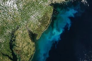
Color Off the Mid-Atlantic Coast

4 min read

Something is brewing in shallow waters offshore of Delaware, New Jersey, Maryland, and Virginia.

Article

Sizing Up the Sargassum Belt

6 min read

Seaweed composing the Great Atlantic Sargassum Belt hit near-record levels in June 2026, with the Caribbean Sea and Gulf of…

Article
  •  

APOD: 2026 August 9 – Contemplating the Sun

APOD

Astronomy Picture of the Day

Discover the cosmos! Each day a different image or photograph of our fascinating universe is featured, along with a brief explanation written by a professional astronomer.

Contemplating the Sun

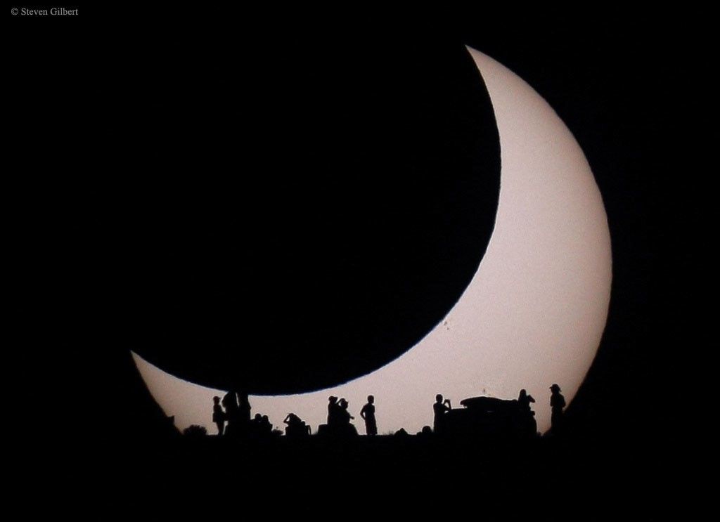
Explanation: Have you contemplated your home star recently? Featured here, a Sun partially eclipsed on the top left by the Moon is also seen eclipsed by earthlings contemplating the eclipse below. This spectacular menagerie of silhouettes was taken in 2012 from the Glen Canyon National Recreation Area near Page, Arizona, USA, where park rangers and astronomers expounded on the unusual event to interested gatherers. Also, faintly visible on the Sun’s disk, just to the lower right of the dark Moon’s disk, is a group of sunspots. A new solar eclipse will occur this week and give many people in northeastern North America, Europe, and northwestern Africa a new chance to contemplate a partially eclipsed Sun. A thin swath of Earth from Greenland to Portugal will further experience a total solar eclipse. An open question is whether any meteors from the peaking Perseids will be visible during totality.

Date August 9, 2026
Credit & Copyright Steven Gilbert
Authors & editors: Robert Nemiroff, Jerry Bonnell, Cecilia Chirenti, Keighley Rockcliffe
A service of: ASD at NASA / GSFC,
NASA Science Activation & Michigan Tech. U.
  •  

APOD: 2026 August 8 – A Messier Moment for Tempel 2

APOD

Astronomy Picture of the Day

Discover the cosmos! Each day a different image or photograph of our fascinating universe is featured, along with a brief explanation written by a professional astronomer.

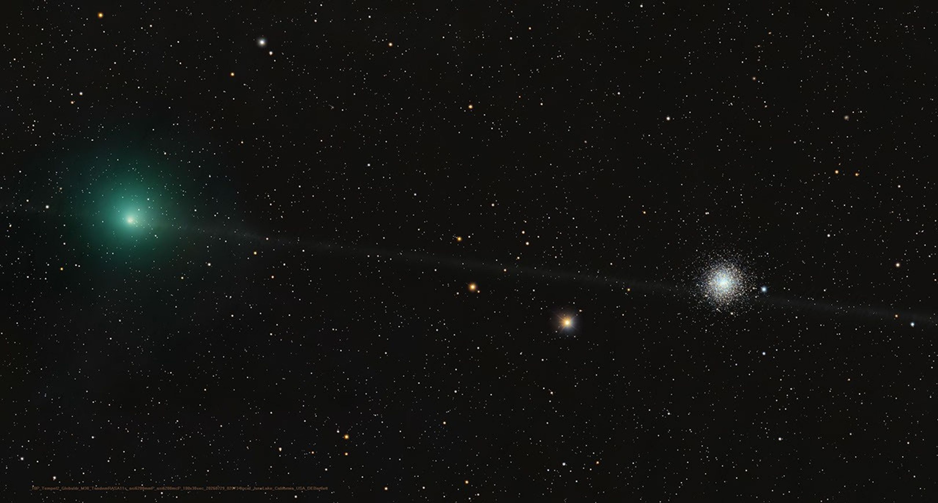
Greenish cometary coma of 10P/Tempel 2 and globular star cluster M30

A Messier Moment for Tempel 2

Explanation: Which of these is not a comet? You guessed it – the one on the right is a globular star cluster. The diffuse greenish coma of periodic comet 10P/Tempel 2 is at left in the frame. In fact the globular star cluster is Messier 30, also known as M30, or the 30th entry in astronomer Charles Messier’s catalog of things which are not comets. The well-known 18th century astronomer kept a list of objects he observed, now his famous Messier Catalogue of Nebulae and Star Clusters, which did not move from night to night against the background stars and so were not the comets he was hunting for. So the famous comet hunter would get the correct answer too, even though his telescope would show both 10P/Tempel 2 and distant star cluster as similar looking faint and fuzzy objects in his field of view. Recorded on July 29, this modern telescopic image captures periodic comet Tempel 2 as it briefly swept close on the sky to M30. While the periodic comet’s faint, narrow, orbital dust trail seems to pierce the globular star cluster, Tempel 2 was a mere 3.5 light-minutes away. Messier 30 is some 28,000 light-years distant.

Tomorrow’s picture: Contemplating the Sun

Date August 8, 2026
Credit & Copyright Dan Bartlett
Authors & editors: Jerry Bonnell, Cecilia Chirenti, Robert Nemiroff, Keighley Rockcliffe
A service of: ASD at NASA / GSFC,
NASA Science Activation & Michigan Tech. U.
  •  

2026 IGARSS Hyperwall Schedule

IGARSS 2026

Join NASA in the Exhibit Hall (Booth #100) for Hyperwall Storytelling by NASA experts. Full Hyperwall Agenda below.

MONDAY, AUGUST 10

3:00 PM  Technology Enabling the Future of Earth Science Mike Seablom
3:15 PM 
Discovery Earth: New Missions & Technical Innovation Advancing Earth System Insights
Karen St. Germain

TUESDAY, AUGUST 11

10:00 AM STELLA: Open-Source Multisenor Platforms For Real-Time Environmental Monitoring Mike Taylor
10:15 AM NOAA Geostationary Satellites: Valuable Data for both Research and Operational Use Dan Lindsey
3:00 PM  Discovering Mineral Resources with NASA Imaging Spectroscopy Robert O. Green
3:15 PM 
The Importance of Satellite Ocean Observations at NOAA
Paul Chang

WEDNESDAY, AUGUST 12

10:00 AM Enabling Earth Science Data to Serve Society Joel Scott
10:15 AM Microwaving the Solar System Shannon Brown
3:00 PM  NISAR Updates, One Year After Launch Paul Rosen, Marco Lavalle
3:15 PM 
Office of the Chief Science Data Officer: Data Driven Exploration
Lauren Leese
  •  

NASA’s IXPE Studies Magnetar

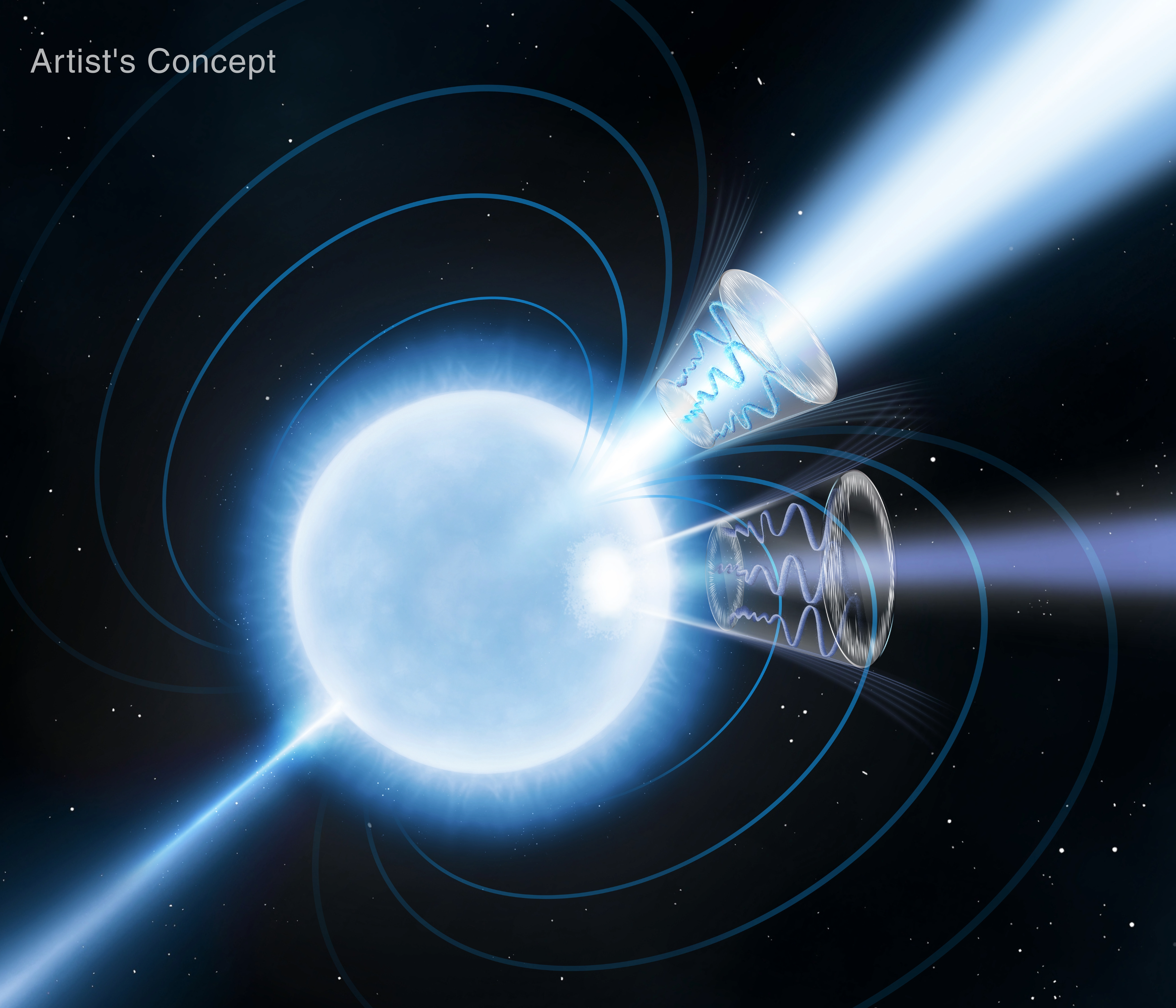
This artist’s concept depicts magnetar 1E 1547.0-5408, a rapidly rotating neutron star with magnetic fields over a trillion times stronger than Earth’s. Blue curves emanating from the star's two magnetic poles represent the magnetic field lines. The magnetar is a significant emitter of radio and X-ray radiation, with their peaks offset during its 2.1-second rotation period. This indicates the primary X-ray emitter is a secondary “hot spot” offset from the magnetic axis. These emitters are depicted as conical sections: the lighter blue radio emission peaks at the magnetic field's symmetry axis, while the darker blue X-ray emission peaks below.
NASA/Pablo Garcia

Scientists using NASA’s IXPE (Imaging X-ray Polarimetry Explorer) conducted more than 140 hours of observations of the magnetar 1E 1547-5408, shown in this Aug. 5, 2026, artist’s concept, between March and April 2025. In doing so, they may have captured empty space behaving in a way physicists have predicted for 90 years, but never directly observed.

Magnetars are a special class of neutron stars with ultra-strong magnetic fields, the strongest of any object in the observable universe, around a trillion times stronger than the strongest permanent magnets ever built on Earth.

Image credit: NASA/Pablo Garcia

  •  

NASA’s Lunar Development and Test Facility Prepares Artemis Hardware for Moon 

3 Min Read

NASA’s Lunar Development and Test Facility Prepares Artemis Hardware for Moon 

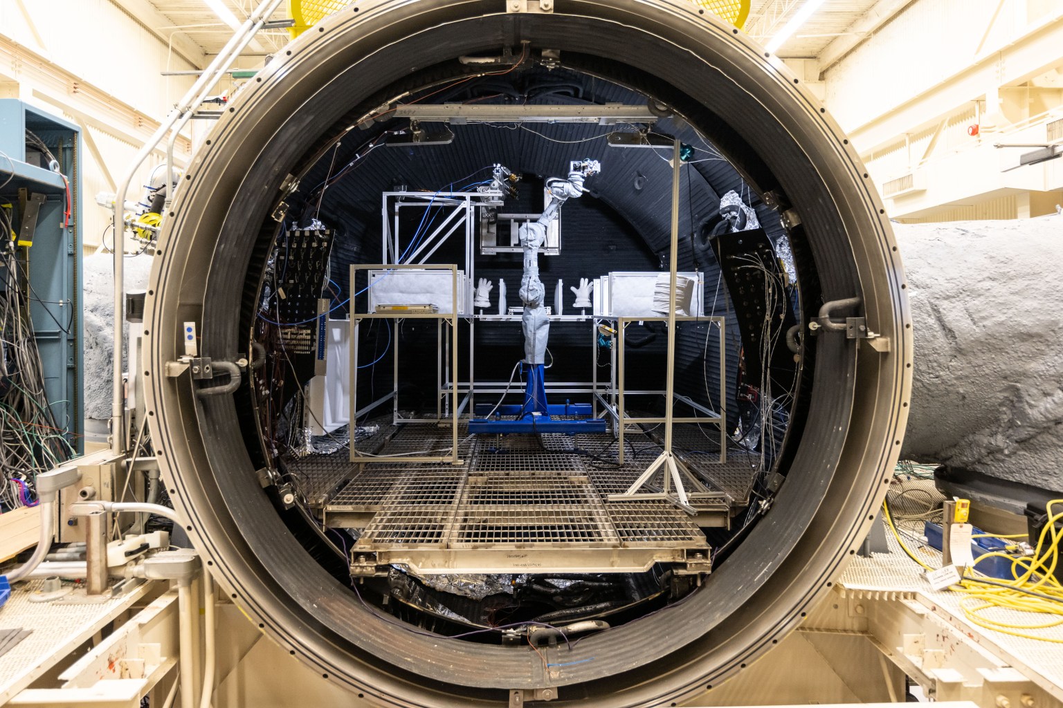
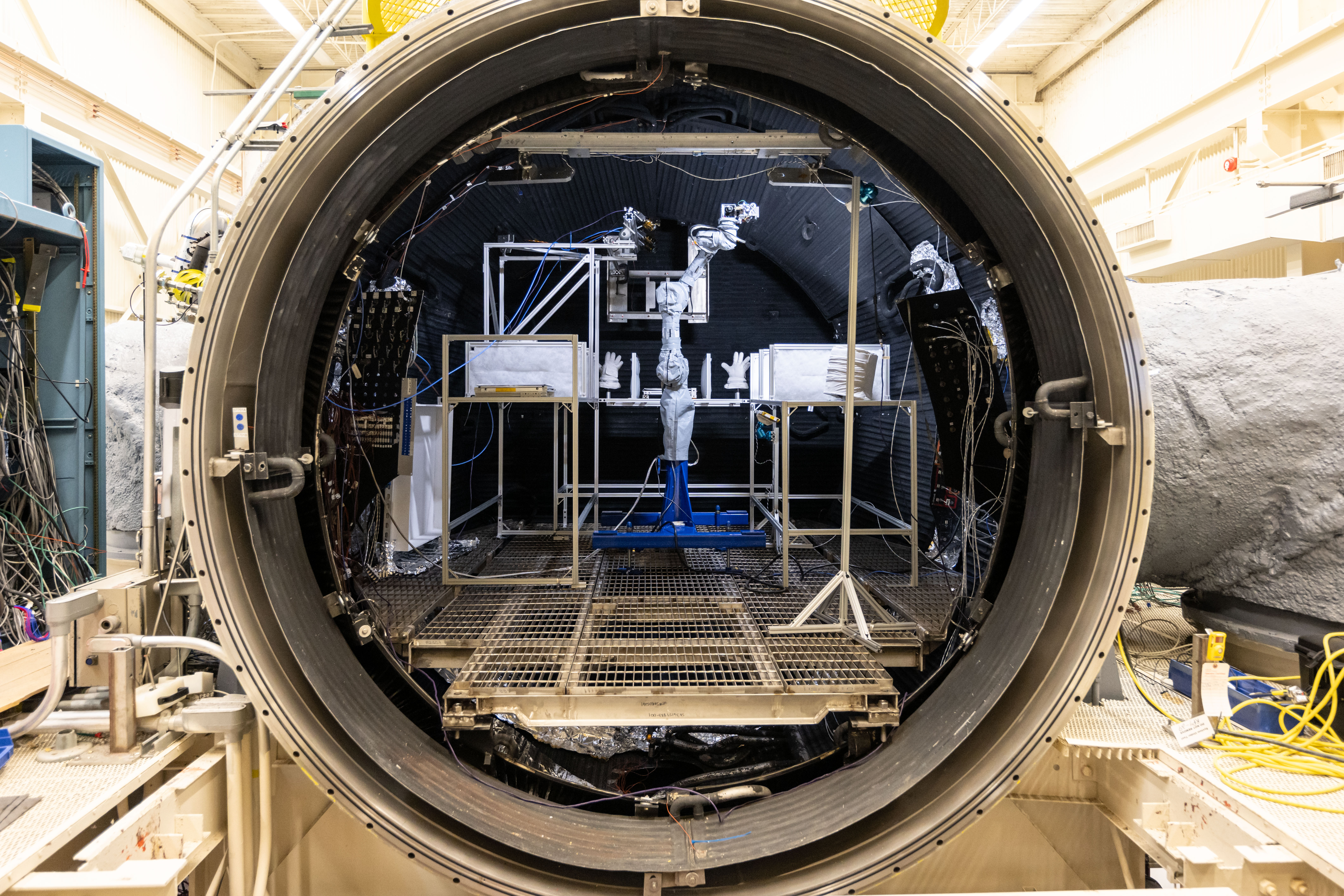
The Handheld Lunar Electrostatic Dust Mitigation tool is tested inside the Lunar Development and Test Facility at NASA’s Johnson Space Center in Houston.
Credits: NASA/Josh Valcarcel

Before astronauts return to the Moon’s surface through NASA’s Artemis program, the hardware they depend on must first prove it can survive the unforgiving lunar environment. At NASA’s Johnson Space Center in Houston, engineers at the Lunar Development and Test Facility are tackling one of exploration’s biggest challenges: Moon dust. 

Unlike sand on Earth, lunar dust is sharp, abrasive, and clings to nearly everything. Without mitigation, lunar dust could damage equipment and spacesuits while posing health risks to astronauts. Understanding and mitigating the effects of lunar dust is essential as astronauts prepare to live and work on the surface of the Moon.  

The Handheld Lunar Electrostatic Dust Mitigation tool is tested inside the Lunar Development and Test Facility at NASA’s Johnson Space Center in Houston.
NASA/Josh Valcarcel

Located within the Energy Systems Test Area and managed by NASA engineers, the Lunar Development and Test Facility supports the development and testing of hardware in simulated lunar conditions. Engineers evaluate systems and subsystems inside vacuum chambers using lunar regolith simulant to better understand how spacesuits, spacecraft components, and mechanisms with moving parts and joints will perform during future Artemis missions. 

Lunar spacewalking tools undergo a dust mitigation test inside Johnson’s thermal vacuum chamber. 
NASA/Bill Stafford

NASA Johnson’s Propulsion and Power Division developed specialized systems that make the facility’s lunar simulations possible. The facility includes a dust containment and preparation laboratory for ambient testing, a 3-foot cube vacuum chamber, and a 15-foot thermal vacuum chamber. 

Inside the chamber, engineers test hardware under realistic lunar conditions using lunar regolith simulant. The chamber uses a closed-loop nitrogen system to recreate the harsh lunar environment.  

“The facility helps develop and test technologies needed for long-duration lunar exploration,” said Mike Salinas, Propulsion and Power Division branch deputy chief. “Engineers are advancing techniques to extract resources from lunar regolith, which can be turned into oxygen for astronauts and liquid oxygen for rocket propellant.” 

The spirit of exploration extends beyond the facility’s walls. Its exterior features a large-scale mural depicting astronauts exploring the lunar surface beneath a view of the cosmos. Completed in 2024 by artist Sebastian Boileau, the artwork celebrates the innovation, ingenuity, and discovery happening inside the building every day. 

Artist Sebastien Boileau, left, and Margaret Braun pose in front of Johnson’s Lunar Development and Test Facility after the mural’s completion on Feb. 7, 2024.
NASA/Josh Valcarcel

Now, anyone can step inside the facility from anywhere. Explore NASA’s new 3D virtual tour of the Lunar Development and Test Facility to see where engineers are helping prepare the technologies that support this Golden Age of exploration and innovation.  

About the Author

Sumer Loggins

Sumer Loggins

Share

Details

Last Updated
Aug 07, 2026
Keep Exploring

Discover More Topics From NASA

  •  

APOD: 2026 August 7 – Rubin’s Cosmos Field

APOD

Astronomy Picture of the Day

Discover the cosmos! Each day a different image or photograph of our fascinating universe is featured, along with a brief explanation written by a professional astronomer.

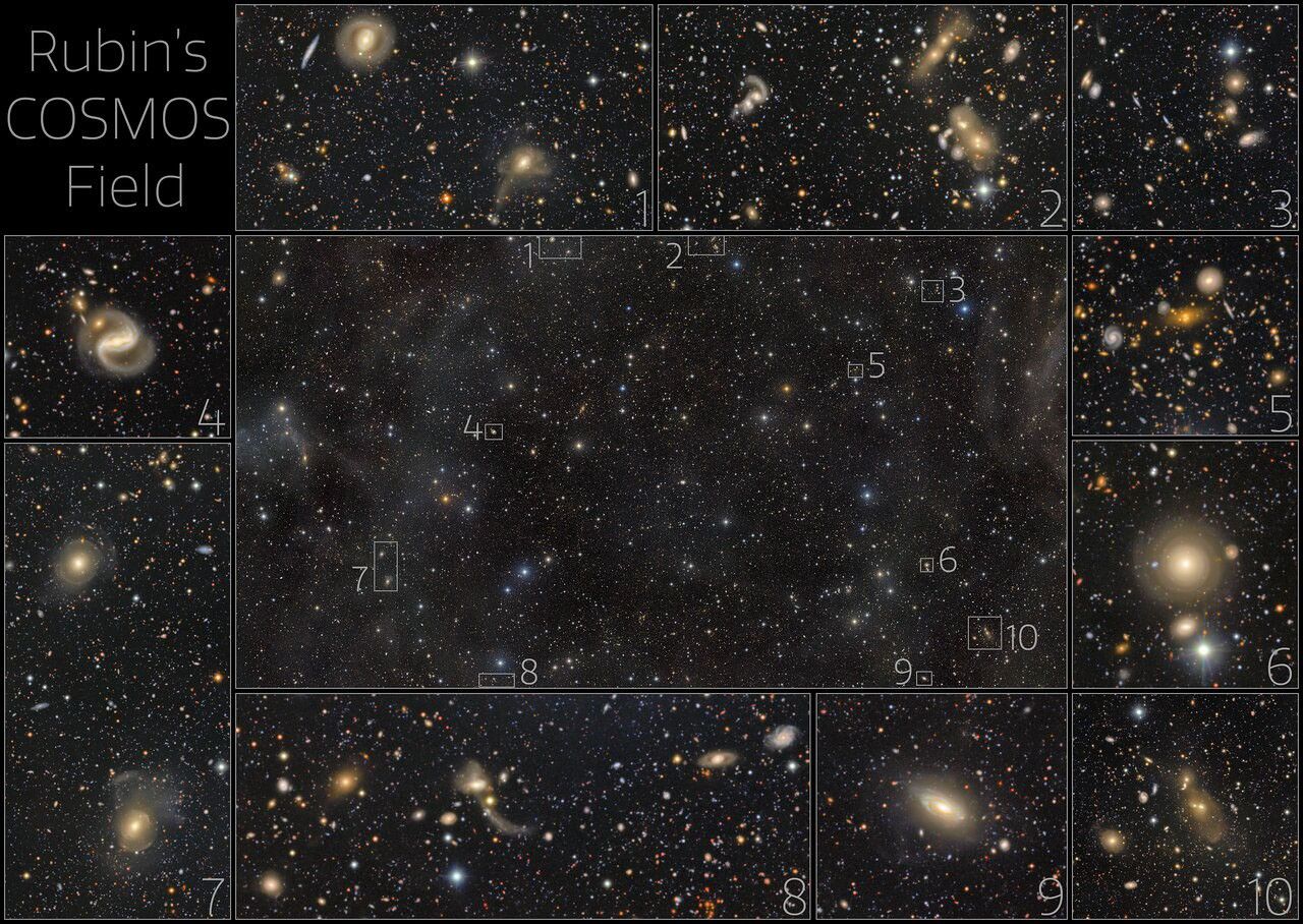
This exceptionally deep image from NSF–DOE Vera C. Rubin Observatory reveals the renowned COSMOS field and its surroundings in the constellation Sextans. The view is crowded with galaxies and galaxy clusters spanning an immense range of distances and cosmic ages, while only a handful of foreground stars belong to our own Milky Way. It was created by combining multiple observations from Rubin’s LSST Camera into a deep co-added image and is being released to mark Early Data Preview 2, the first Rubin data preview based on LSST Camera observations. Here, some selected areas are highlighted. 

Rubin’s COSMOS Field

Explanation: There are more than half a million galaxies in the central panel of this image from the NSF-DOE Vera C. Rubin Observatory in Chile. This is the COSMOS field, a patch of sky several times larger than the full moon, first observed by Hubble. It has also been observed by Webb and other telescopes because it contains comparatively few bright stars from our own galaxy, offering a relatively unimpeded view of other galaxies outside the Milky Way. The outer panels, numbered 1-10, show zoomed-in views of the corresponding small regions highlighted in the central panel. The variety of galaxy shapes and sizes is astonishing. Some of them are so far away that their light has traveled for billions of years before reaching Earth. Rubin will come back every couple of days to the COSMOS field as part of its ten-year Legacy Survey of Space and Time. It will allow a dynamic view of the COSMOS field and how the sky changes over time.

Tomorrow’s picture: a Messier moment

Date August 7, 2026
Credit & Copyright NSF–DOE Vera C. Rubin Observatory/NOIRLab/SLAC/AURA
Authors & editors: Cecilia Chirenti, Jerry Bonnell, Robert Nemiroff, Keighley Rockcliffe
A service of: ASD at NASA / GSFC,
NASA Science Activation & Michigan Tech. U.
  •  

Sensing the Poles’ Hidden Heat

Surface temperatures across Earth’s poles pulse with the seasons, as seen in this animation based on two years of data collected by NASA’s PREFIRE (Polar Radiant Energy in the Far-InfraRed Experiment) mission.
NASA/Chad Greene

At the top and bottom of the planet, the seasons arrive on a schedule all their own. Satellite data from a mission measuring infrared energy reveal just how differently—and how dramatically—surface temperatures swing across two full years at the poles.

In this animation, surface temperatures across the Arctic and Antarctic pulse between cold (dark blue) and milder to warm (lighter blue to red). Data for the animation come from NASA’s PREFIRE (Polar Radiant Energy in the Far-InfraRed Experiment) satellites. The mission’s twin CubeSats began collecting science data in July 2024 and have now captured two complete seasonal cycles at each pole.

Because the two poles sit in opposite hemispheres, their seasons occur at opposite times—and the swing between seasons differs, too. In the Arctic, cold, dark winters give way to summers warm enough to thaw vast stretches of tundra and sea ice. In Antarctica, Earth’s coldest continent, summer temperatures rarely climb above freezing before the bitter cold of winter returns.

Surface temperatures, and how they fluctuate, offer a window into Earth’s energy budget, the net flow of energy into and out of the Earth system. Sunlight absorbed by the surface is re-radiated as infrared heat, which bounces between Earth’s surface and atmosphere before escaping to space. The poles play an important role in this process. Atmospheric and ocean circulation carries excess heat absorbed in the tropics toward the poles, where it radiates away to space, helping regulate the planet’s temperature.

“By measuring invisible heat radiating from Earth’s coldest places, PREFIRE is helping scientists understand why the poles are changing so rapidly, and what those changes might mean for the rest of the planet,” said Chad Greene, a glaciologist at NASA’s Jet Propulsion Laboratory.

Scientists have long known that far-infrared radiation accounts for nearly 60 percent of the energy Earth loses to space, but that portion of the spectrum—invisible to human eyes—had never been comprehensively measured on a global scale. By directly tracking this invisible energy in near-real-time, the PREFIRE mission is helping scientists refine models and gain a better understanding of the Earth system.

“Weather systems, river flows, shipping routes, and ice sheet stability are all influenced by energy movement in a part of the spectrum that only PREFIRE can see,” said Tristan L’Ecuyer, an atmospheric scientist at the University of Wisconsin-Madison and principal investigator of the PREFIRE mission. “Now that the invisible has been made visible, we can begin to improve weather and climate predictions that industries, our national defense, and Arctic communities rely on.”

Maps courtesy of Chad Greene, NASA/JPL, using data from NASA’s PREFIRE mission. Story by Kathryn Hansen.

References & Resources

You may also be interested in:

Stay up-to-date with the latest content from NASA as we explore the universe and discover more about our home planet.

A Moonlit Earth as Seen From Artemis II

4 min read

An astronaut’s photo, taken en route to the Moon, reveals our planet and its place in space in a novel…

Article

Earthset From the Lunar Far Side

2 min read

The crew of NASA’s Artemis II mission captured extraordinary images of our home planet during their journey around the far…

Article

June 2026 Satellite Puzzler

2 min read

Your challenge is to tell us the location of the satellite image and why it is interesting.

Article
  •  

Educators & Teens Get Hands-On With TEMPO Data to Help Investigate Local Air Quality

4 min read

Educators & Teens Get Hands-On With TEMPO Data to Help Investigate Local Air Quality

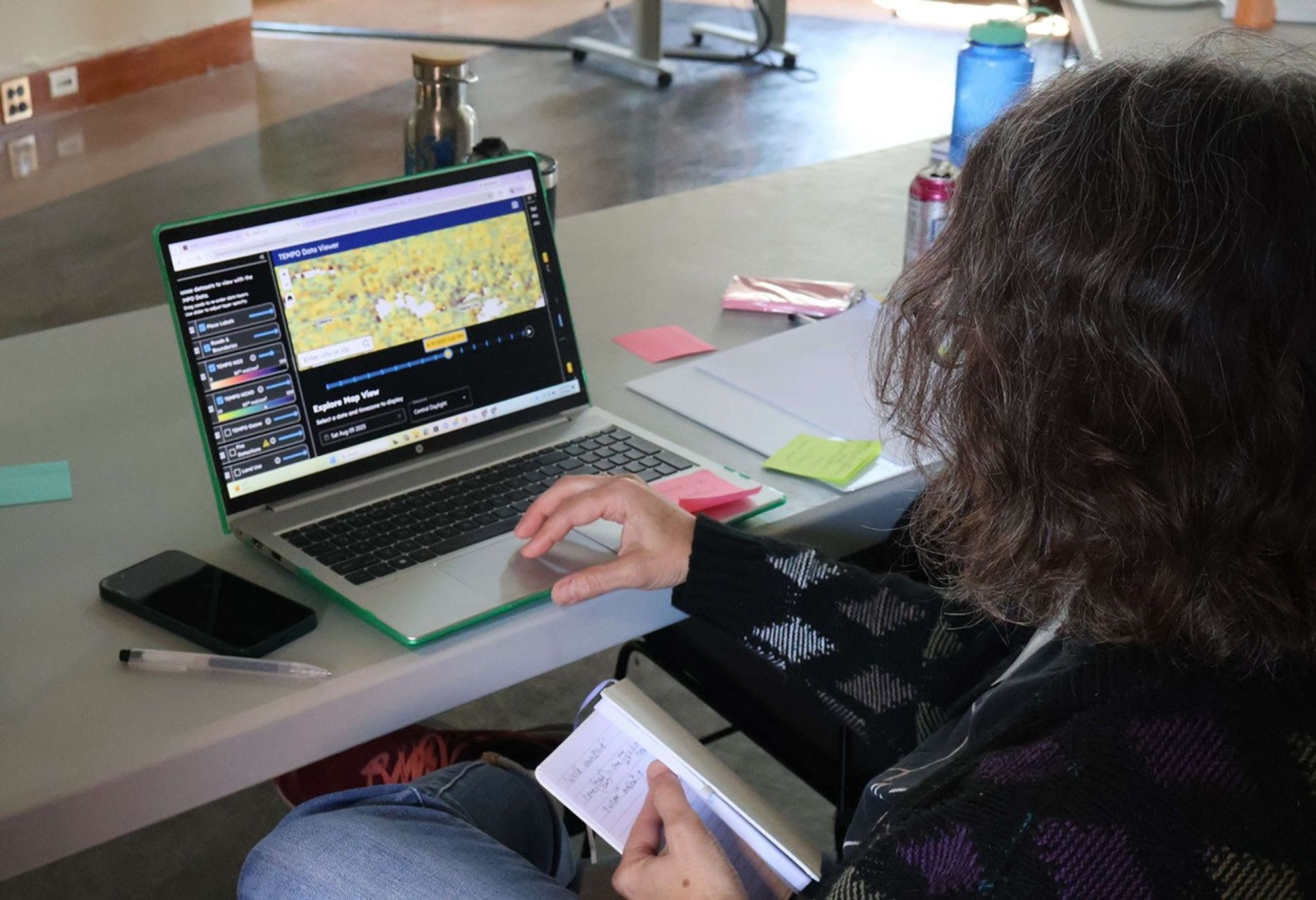
A workshop participant, seen from behind, sits at a laptop displaying the TEMPO-Lab Data Viewer. The screen shows a colorful satellite map of air quality data over the central United States, with toggleable data layers for NO2, HCHO, ozone, and fire detections listed on the left panel. The participant holds a small notebook and pen while working through the tool at a table scattered with sticky notes and water bottles.
An educator explores NASA’s TEMPO mission data using the CosmicDS TEMPO-Lab viewer during a hands-on immersion session at the BEST AQI Leadership Institute.
Credit: Devika Elakara

The NASA Science Activation Program’s Cosmic Storytelling with NASA Data (CosmicDS) project, led by Harvard University in Cambridge, Massachusetts, works to bring authentic NASA data into the hands of educators and learners. From July 27–29, 2026, the CosmicDS team partnered with the Smithsonian Institution’s BEST AQI (Breathing Easier: Supporting Teen Air Quality Investigations) project to host a Leadership Institute at the Center for Astrophysics | Harvard & Smithsonian (CfA) in Cambridge, MA. The Institute brought together 13 formal and informal educators who serve as advisors to BEST AQI, an initiative that guides teens through their own air quality research to support actions that improve air quality in their communities.

On Day 1 of the Institute, the CosmicDS Science Principal Investigator Pat Udomprasert led a hands-on immersion session introducing educators to TEMPO-Lab, a free online tool built with NASA Science Activation Program funding. TEMPO-Lab lets learners explore and analyze near-real-time air quality measurements collected by NASA’s TEMPO (Tropospheric Emissions: Monitoring of Pollution) mission, which measures pollution across North America hourly during daylight hours. During Days 2 and 3 of the Institute, as educators worked together to co-develop BEST AQI curriculum and resources, they used TEMPO-Lab to build case studies covering a variety of real-world air quality scenarios, including wildfire smoke and emissions from rush-hour traffic, power plants, and agriculture. These case studies will give the teens in their programs a strong foundation for investigating air quality where they live and deciding what actions they might take in their own communities.

One moment made the workshop especially memorable. During a science briefing, TEMPO scientist Heesung Chong shared that a new beta-version ground-level ozone data product had recently become available. TEMPO-Lab’s flexible design made it possible for CosmicDS software developer and educator John Lewis to integrate the new data product into the tool overnight, letting workshop participants explore cutting-edge ozone data themselves the very next morning. It was a striking example of how CosmicDS’s data tools can match the pace of active NASA science, giving educators and their learners access to data almost as soon as scientists themselves do.

“The BEST AQI Leadership Institute reinforced the value of the TEMPO-Lab as a tool for empowering youth to investigate local air quality issues using authentic NASA data. Educators were excited not only by the scientific capabilities of the platform, but by its potential to help young people use evidence to make informed decisions and contribute to positive change in their communities.”

— Erika Wright, Education Specialist, Smithsonian Astrophysical Observatory (SAO), and BEST AQI Principal Investigator

Equipping educators with both the technical skills and the curriculum to bring NASA air quality data into their classrooms matters because it builds data literacy skills that teens can carry into any career, while also giving them the tools to investigate issues that affect their health and their own communities. Air quality is a subject teens can see, smell, and feel the effects of — and BEST AQI is designed to help them turn that lived experience into evidence-based understanding and, ultimately, action.

The CosmicDS team will continue supporting these efforts in the year ahead. The 13 educators who attended this Leadership Institute plan to share the BEST AQI toolkit and TEMPO-Lab with approximately 100 additional educators across their partner sites in South Dakota, Maryland, and New York, potentially extending this work to thousands of teen air quality researchers.

Experience TEMPO-Lab at https://projects.cosmicds.cfa.harvard.edu/tempo-lab and learn more about the CosmicDS project at https://cosmicds.cfa.harvard.edu.

Cosmic DS is supported by NASA cooperative agreement award number 80NSSC21M0002 and is part of the NASA Science Activation Program portfolio, which connects learners with authentic NASA science experiences through partnerships with educators and community organizations.

Share

Details

Last Updated
Aug 07, 2026
Editor
NASA Science Editorial Team
  •  

NASA’s SkyFall Helicopters at Work (Artist’s Concept)

2 Min Read

NASA’s SkyFall Helicopters at Work (Artist’s Concept)

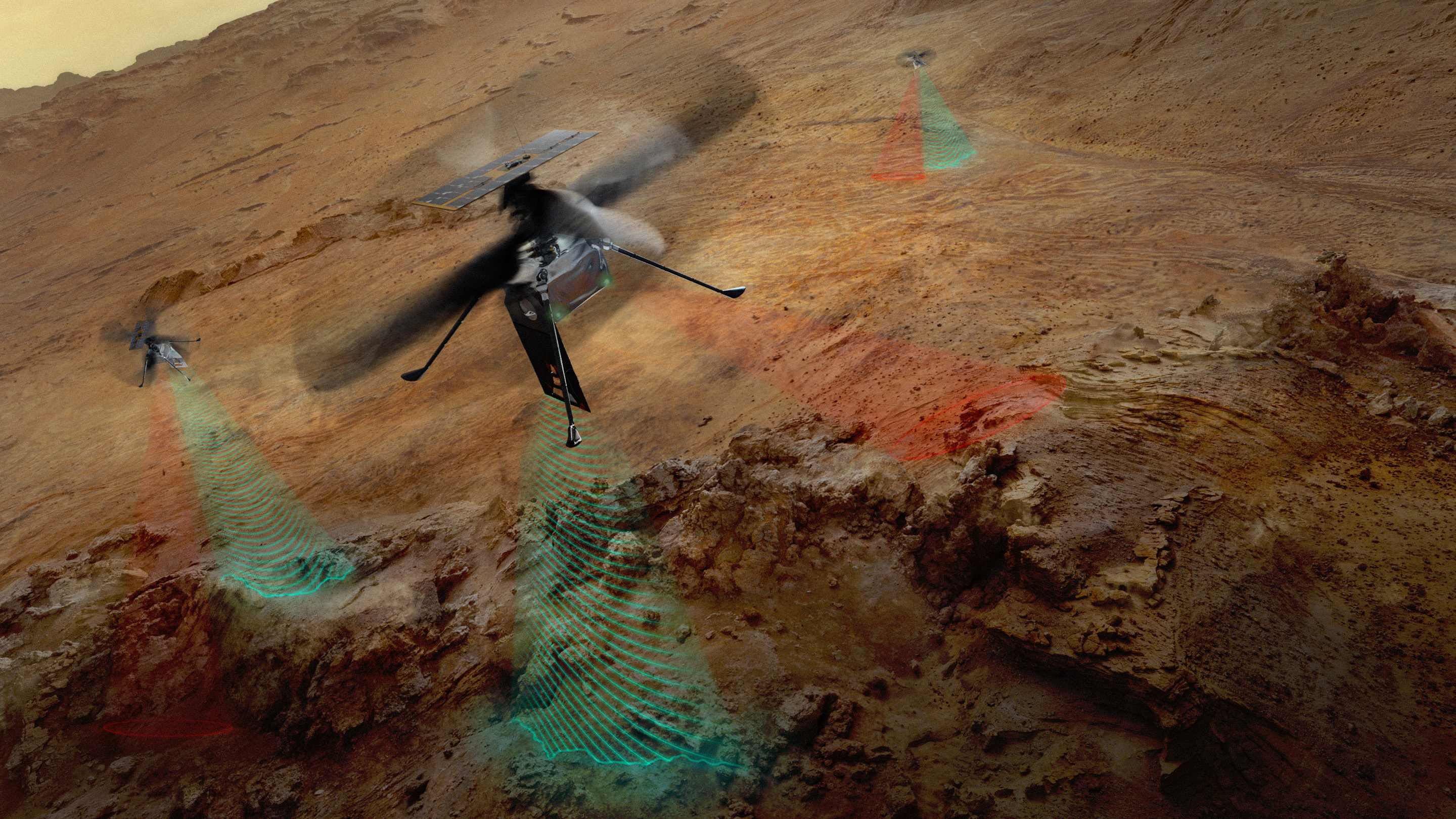
Three drone helicopters fly over a barren, reddish-brown rocky landscape. The foreground drone and two smaller drones in the background all project wavy, translucent red and green beams of light downward onto the rugged terrain below.
PIA26760
Credits:
NASA/JPL-Caltech

Downloads

NASA’s SkyFall Helicopters at Work (Artist’s Concept)

JPEG (3.25 MB)

Description

This artist’s concept depicts NASA’s three SkyFall Mars helicopters collecting data while flying over the surface of the Red Planet. 

The green frequency waves emanating from the helicopters’ large antennas depict collection of subsurface radar data. The red beams depict collect near-infrared imagery data from regolith (crushed rock and dust) and other surface features.

Equipped with four instruments each, the three helicopters will follow in the footsteps of the agency’s Ingenuity Mars Helicopter, a technology demonstrator that flew 72 times over nearly three years, proving that powered, controlled flight is possible in the rarefied Martian atmosphere. It also demonstrated how an aerial perspective can generate valuabledata by helping NASA’s Perseverance Mars rover team plan time-saving routes and choose locations for science-gathering. 

SkyFall is expected to launch aboard NASA’s Space Reactor-1 Freedom in late 2028. 

The SkyFall project, which will carry three Mars helicopters to the Red Planet in December 2028, is managed by NASA’s Jet Propulsion Laboratory. AeroVironment of Arlington, Virginia — which worked with JPL to design and build the history-making Ingenuity rotorcraft — will co-design and co-manufacture the SkyFall helicopters. Managed by Caltech for NASA, JPL manages the overall Mars Exploration Program on behalf of NASA’s Science Mission Directorate in Washington. 

For more information about NASA’s SkyFall:

https://science.nasa.gov/mission/skyfall/

  •  

Antenna Testing for NASA’s SkyFall Mission

1 Min Read

Antenna Testing for NASA’s SkyFall Mission

A gloved person in striped shirt and glasses attaches a blue cable to a device with a metallic base and a translucent-appearing pane. The background is a chamber lined with grey and blue geometric foam acoustic panels.
PIA26759
Credits:
NASA/JPL-Caltech

Downloads

Antenna Testing for NASA’s SkyFall Mission

JPEG (30.46 MB)

Description

SkyFall ground-penetrating radar engineer Maya Román connects a coaxial cable to a test antenna in the Environmental Test Lab’s electromagnetic interference testing chamber at NASA’s Jet Propulsion Laboratory in Southern California. 

The antenna was pointed up during test to minimize reflections and interferences with the antenna pattern during the measurement.

Equipped with four instruments each, the three SkyFall aircraft will follow in the footsteps of the agency’s Ingenuity Mars Helicopter, which flew 72 times over nearly three years, proving that powered, controlled flight is possible in the rarefied Martian atmosphere. It also demonstrated how an aerial perspective can generate valuable data by helping NASA’s Perseverance Mars rover team plan time-saving routes and choose locations for science-gathering. 

SkyFall is expected to launch aboard NASA’s Space Reactor-1 Freedom in late 2028.

  •  

I Am Artemis: Tom Percy

3 Min Read

I Am Artemis: Tom Percy

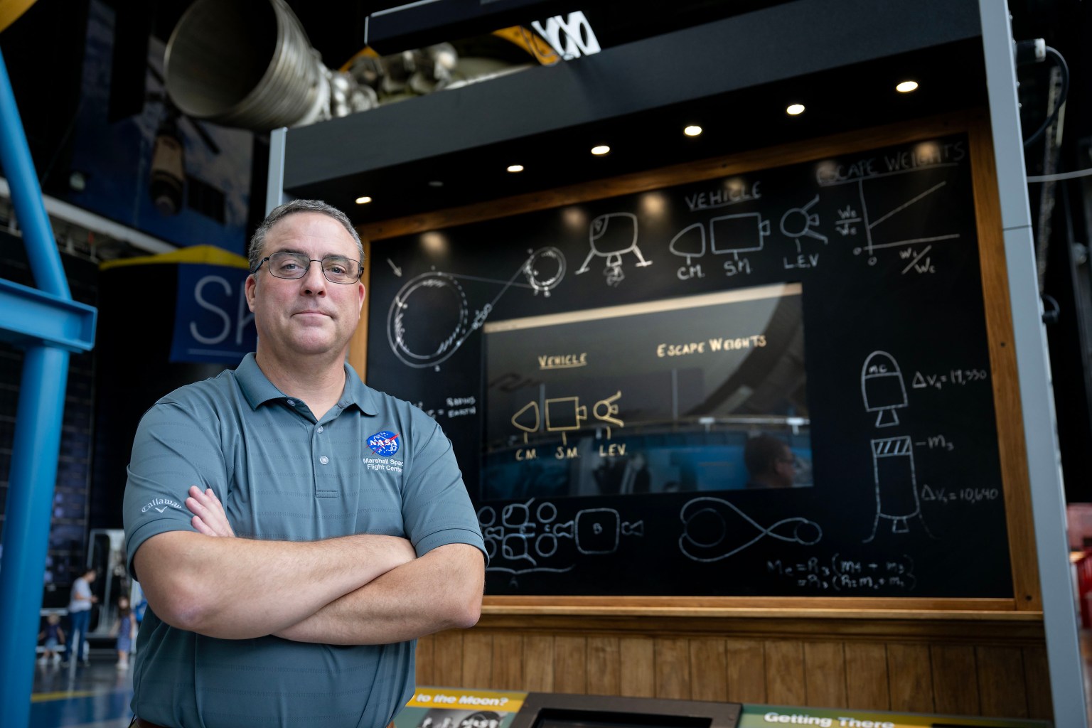
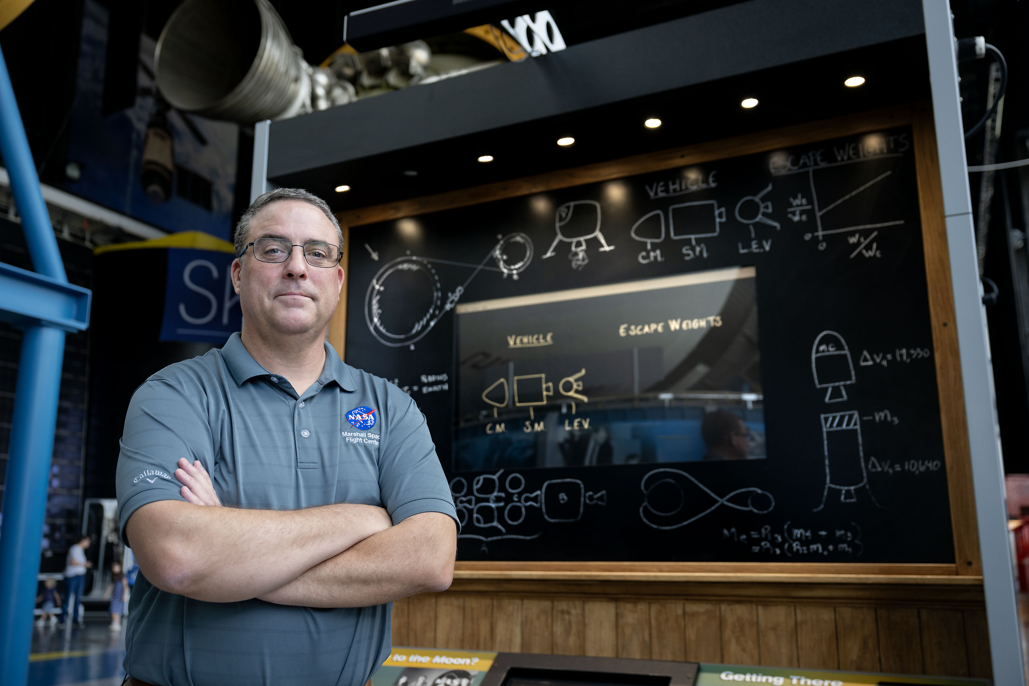
Tom Percy, manager of systems engineering and integration for NASA’s Human Landing Systems Program, stands in front of an Apollo Program lander exhibit at the U.S. Space and Rocket Center in Huntsville near NASA’s Marshall Space Flight Center.

As NASA sets its sights on long-term exploration of the Moon and Mars, the agency is increasing the cadence of its Artemis missions. Helping bring these plans to fruition is Tom Percy, manager of systems engineering and integration for NASA’s Human Landing System Program.

Tom Percy, manager of systems engineering and integration for NASA’s Human Landing Systems Program, stands in front of an Apollo Program lander exhibit at the U.S. Space and Rocket Center in Huntsville near NASA’s Marshall Space Flight Center.
NASA/Charles Beason

Percy serves as a focal point in working with providers SpaceX and Blue Origin to accelerate and streamline systems designs, manufacturing, testing, and certification. He ensures the crewed landers that SpaceX and Blue Origin are developing for Artemis are designed, built, tested, and will operate with other NASA exploration assets safely and effectively.

“You might say that all human landing system integration work lands on my desk. And with the rest of my talented, hard-working systems engineering and integration team, we’re working to make it all happen,” Percy said.

A native of North Easton, Massachusetts, Percy earned a bachelor’s degree in mechanical engineering from the Rochester Institute of Technology in Rochester, New York, where he first got hands-on experience working on designs that could be applied to NASA’s sustainable lunar architecture.

“As an undergrad, I served as president of the Rochester Institute of Technology’s chapter of the American Society of Mechanical Engineers. To get some real-world engineering experience, we decided to participate in the Great Moonbuggy Race,” Percy said. “Now called the Human Exploration Rover Challenge, the competition is held annually at NASA’s Marshall Space Flight Center in Huntsville, Alabama.

“At the time, I had never heard of Marshall Space Flight Center,” said Percy. “But our student team designed and built a rover and traveled to Huntsville for the race. That’s when I learned about some of the projects in Marshall’s diverse portfolio that the center works for NASA. And that’s when I began planning to make my way to NASA Marshall for my career.”

Percy chose to move south and earn a master’s degree in aerospace engineering from the Georgia Institute of Technology in Atlanta. His research in the advanced propulsion lab and courses in space systems design culminated in a spacecraft design course and the chance to work directly with engineers at Marshall.

Since landing at Marshall in 2003, Percy has been involved in evaluating transportation architecture options for human deep space exploration, including missions to land astronauts on the Moon and Mars. He also has expertise in space transportation, including advanced propulsion technology development; trajectory analysis; and spacecraft and mission concept development. Percy earned a doctorate in aerospace systems engineering from the University of Alabama in Huntsville.

The range of experience comes together in his current role as manager of human landing systems engineering and integration.

“The world watched the amazing success of Artemis II. NASA and our commercial providers are looking forward to flying again soon and executing increasingly complex Artemis missions,” Percy said.

Through the Artemis program, NASA will send astronauts on increasingly complex missions to explore more of the Moon for scientific discovery, economic benefits, establish an enduring human presence on the lunar surface, and to build on our foundation for the first crewed missions to Mars.

To learn more about the Artemis program, visit:

https://www.nasa.gov/artemis

About the Author

Beverly Perry

Communications Strategist

Share

Details

Last Updated
Aug 06, 2026
Editor
Lee Mohon
Contact
Keep Exploring

Discover More Topics From NASA

  •  
❌