NASA’s Chandra Discovers Possible Supernova Remnant in Galactic Center
Astronomers may have uncovered a new supernova remnant in a star-forming region near the center of the Milky Way galaxy using data from Chandra and XMM-Newton. If confirmed, this would be one of the closest supernova remnants to the supermassive black hole in the Galactic Center. This image shows the region where the evidence was found, which contains X-rays from Chandra and XMM-Newton, radio data from the MeerKAT telescope in South Africa, and an optical image from the Pan-STARRS telescopes in Hawaii.
Using data from NASA’s Chandra X-ray Observatory, astronomers may have found a supernova remnant in an intriguing neighborhood in the middle of our galaxy. A paper describing these new findings published in The Astrophysical Journal.
Supernova remnants are the expanding remains of exploded stars and provide elements – like iron, oxygen, and silicon – that are critical for the formation of planets and for life as we know it to form and flourish.
This new supernova remnant, if confirmed, would be one of the closest ever discovered to the supermassive black hole at the central region of the Milky Way galaxy, an exotic region crammed with massive stars, long threads of magnetic fields and dense clouds of gas orbiting rapidly around the Galactic Center.
Astronomers may have uncovered a new supernova remnant in a star-forming region near the center of the Milky Way galaxy using data from Chandra and XMM-Newton. If confirmed, this would be one of the closest supernova remnants to the supermassive black hole in the Galactic Center. This image shows the region where the evidence was found, which contains X-rays from Chandra and XMM-Newton, radio data from the MeerKAT telescope in South Africa, and an optical image from the Pan-STARRS telescopes in Hawaii.
A new composite image of this region contains X-rays from Chandra and ESA’s (European Space Agency’s) XMM-Newton mission (shown in blue) as well as radio data from the MeerKAT telescope (shown in red) in South Africa. These have been combined with an optical image from the Pan-STARRS telescopes in Hawaii (red, green, and blue). The plane of the galaxy runs horizontally from left to right in the image, and the central black hole is off to the left of the image.
The evidence for the new supernova remnant, located about 26,000 light-years from Earth, comes from X-ray data from Chandra and XMM-Newton. The X-ray data reveals a “blob” of X-ray emission that may come from the remains of a massive star that self-destructed as a supernova, buried within the larger cloud of expanding gas.
The location of this suspected supernova remnant in the image is labeled with a circle.
It is in a bubble of gas that has had electrons stripped away from hydrogen – called an “H II region” – surrounding a massive, young star. This bubble is a bright source of radio emission called Sagittarius C.
If this is indeed a supernova remnant, then it is expanding at about two million miles per hour and is at least about 1,700 years old. Previously, observations with NASA’s now-retired SOFIA (Stratospheric Observatory for Infrared Astronomy) mission had shown evidence for an expanding shell of gas surrounding Sagittarius C. This gave astronomers a hint that a stellar explosion had occurred in the same spot.
The long filaments seen in the radio image are caused by energetic particles travelling along magnetic fields that are mostly directed perpendicular to the plane of the galaxy.
The nuclear fusion engines of stars create elements from hydrogen and helium that were abundant at the beginning of the universe. When stars explode at the end of their lives as supernovae, they send these newly synthesized elements into interstellar space and provide material for the next generation of stars and planets.
The team of astronomers searched the X-ray data for signs of increased amounts of key elements in the remnant, which would have been caused by the stellar explosion blasting them into space. While they did not see an enhancement, this could imply that the stellar debris has already mixed with the surrounding gas.
An alternative explanation for the X-ray blob is that the hot gas comes from a collection of massive stars in the region. The authors of the recent study don’t think this explanation is likely, because the X-ray emission from the blob is more than ten times brighter than the X-ray emission of large, known stellar clusters with bright, massive stars.
An additional image shows data from NASA’s James Webb Space Telescope added to the X-ray and radio data. The light blue color represents infrared light from gas in the H II region, and the darker blue depicts X-rays from the supernova remnant candidate, on the right side of the image. X-rays near the center of the image are associated with the H II region, possibly caused by material blown away by massive stars that has heated gas to millions of degrees, producing X-rays.
Sagittarius C, close-up image adding NASA’s James Webb Space Telescope data to the X-ray and radio data.
The study’s authors are Zhenlin Zhu and Mark Morris of the University of California, Los Angeles; Gabriele Ponti of Italy’s National Institute for Astrophysics; and Ping Zhou of Nanjing University in China.
NASA’s Marshall Space Flight Center in Huntsville, Alabama, manages the Chandra program. The Smithsonian Astrophysical Observatory’s Chandra X-ray Center controls science operations from Cambridge, Massachusetts, and flight operations from Burlington, Massachusetts.
Visual Description
This release features a composite image of colorful, overlapping clouds, which suggests to astronomers that a supernova remnant may be buried in gas near the center of our Milky Way galaxy.
Set against a backdrop packed with distant stars and other specks of light are two distinct, overlapping clouds. The larger, visually dominant cloud, is red and multifaceted. It has an irregular shape, and features patches of different textures, including pockets that resemble wispy smoke, tangles of faint red veins, and clear streaking lines. This large cloud of expanding gas represents radio data from the MeerKAT telescope in South Africa.
Overlapping with that red cloud is a cloudy blue blob representing X-ray data from NASA’s Chandra X-ray Observatory and ESA’s XMM-Newton. Astronomers suggest that this blue blob of X-ray emissions is the remains of a massive star destroyed by a supernova.
Structures and Materials, Associate Director, Research Directorate at NASA’s Langley Research Center
Martin Annett is the Associate Director of the Structures and Materials Division at NASA’s Langley Research Center, where he leads cutting-edge research in structures and materials in support of aeronautics and space missions.
He has recently served in key leadership roles as Chief Engineer and Program Manager for NASA’s Science and Space Technology Mission Directorates. From 2008 to 2021, Martin contributed to major advancements in aircraft and rotorcraft crashworthiness at Langley’s Landing and Impact Research Facility, serving as Technical Lead for Impact Dynamics and Injury Biomechanics, Head of the Structural Dynamics Branch, and Facility Manager.
Prior to joining NASA, Martin held positions at Johns Hopkins University Applied Physics Laboratory, Orbital Sciences Corporation, and the Aerospace Corporation, where he conducted structural dynamics testing and analysis in support of missile defense systems, spacecraft structures and opto-mechanical instruments, and injury biomechanics programs.
Martin holds an M.S. in Mechanical Engineering from George Washington University and a B.S. in Aerospace Engineering and Mechanics from the University of Minnesota.
He has authored or co-authored more than 40 technical papers and is an active member of the Vertical Flight Society’s Crash Safety Committee.
Listen to this audio excerpt from Elkin Norena, resident management officer, NASA’s Space Launch System Program:
0:00 / 0:00
NASA’s Elkin Norena has helped the agency launch more than a dozen space shuttle missions – that’s more than a dozen crews to low Earth orbit and more than a dozen historic missions. They were missions that helped build the International Space Station, that provided a final servicing mission to the Hubble Space Telescope, and that performed critical science experiments that improved life right here on Earth.
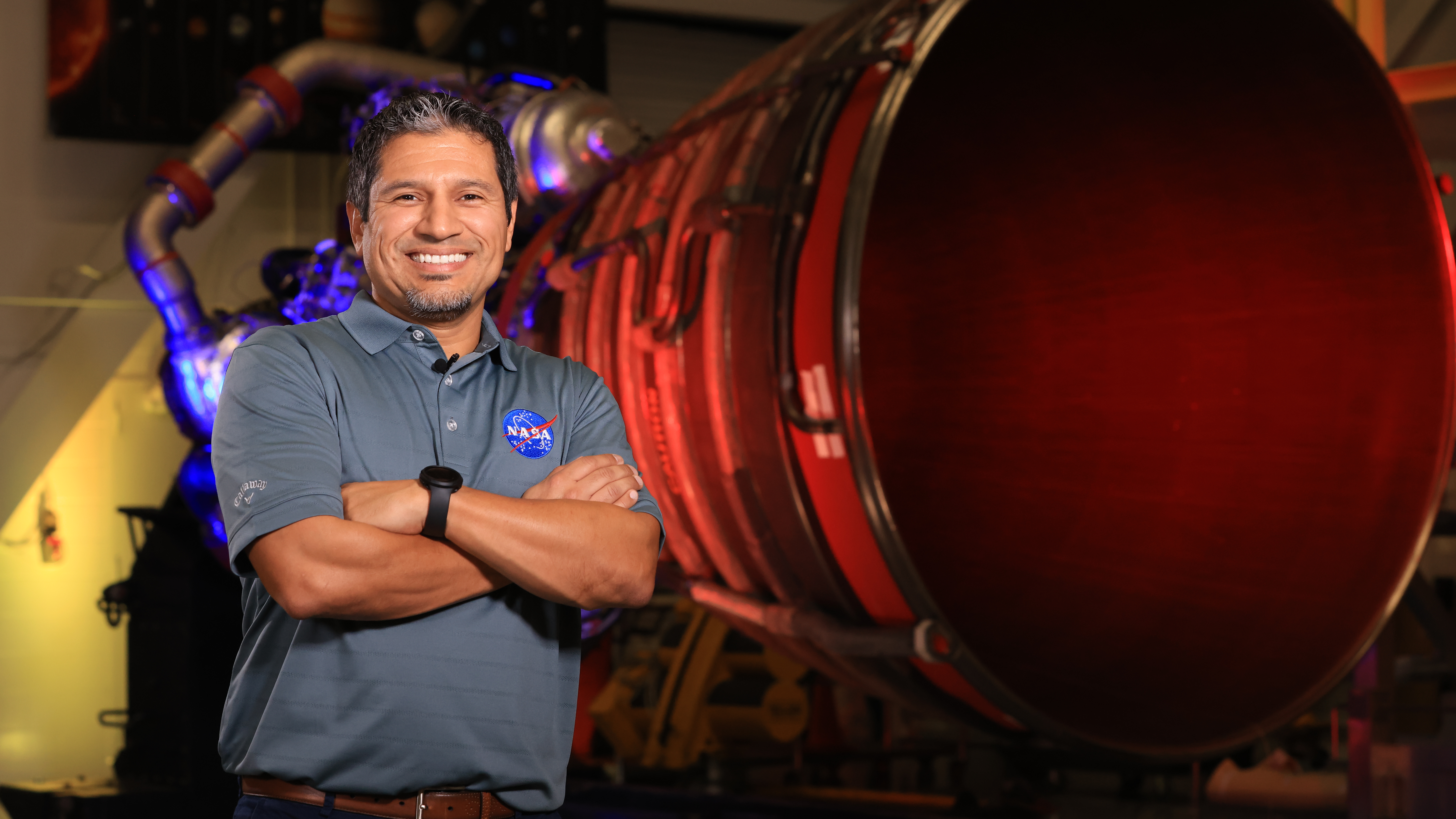
Today, he continues that work as the manager of the Resident Management Office for SLS at NASA’s Kennedy Space Center in Florida, helping launch America’s rocket – the SLS (Space Launch System) – and the Orion spacecraft with its international quartet of astronauts on the Artemis II mission to fly by the Moon and return home.
Elkin Norena, who serves as an SLS resident management officer at NASA’s Kennedy Space Center in Florida, stands in front of an RS-25 engine.
NASA
As resident manager, Norena provides onsite SLS support for NASA’s Exploration Ground Systems team that is responsible for preparing, stacking, testing, and launching SLS and Orion. He is also the eyes and ears for the SLS Program, providing an avenue of communications back to the program, which is managed at NASA’s Marshall Space Flight Center in Huntsville, Alabama.
It is the continuation of a childhood dream to be part of space exploration.
“When I was a kid in New Jersey, I watched a space shuttle launch in class one day,” said Norena. “When I watched the power of launch and the brave astronauts going to explore, I knew I had to be a part of that one day. I wanted to become an astronaut.”
The dream to join the space program led the Colombia native to the University of Central Florida in Orlando, where he majored in computer engineering, just miles from the Space Coast and in view of space shuttle launches like the ones he once watched on TV.
When that clock ticks down to T-10 minutes, everybody’s just waiting. You wait for the automated system to kick in. You hold your breath and watch the clock go down to T-0. Then BOOM, launch happens, and you know it was all worth it.
Elkin Norena
Resident management officer, NASA Space Launch System Program
Following college, he joined NASA contractor United Space Alliance at NASA Kennedy, and in 2008 he joined the NASA Kennedy team as a civil servant, working on the same spacecraft that inspired him to pursue the space program as a child.
“I started off in the Space Shuttle Program as an electrical engineer. Then I moved into the firing room for 17 different shuttle missions as a flight termination engineer. It was exciting to be part of all those missions and build the International Space Station,” Norena said.
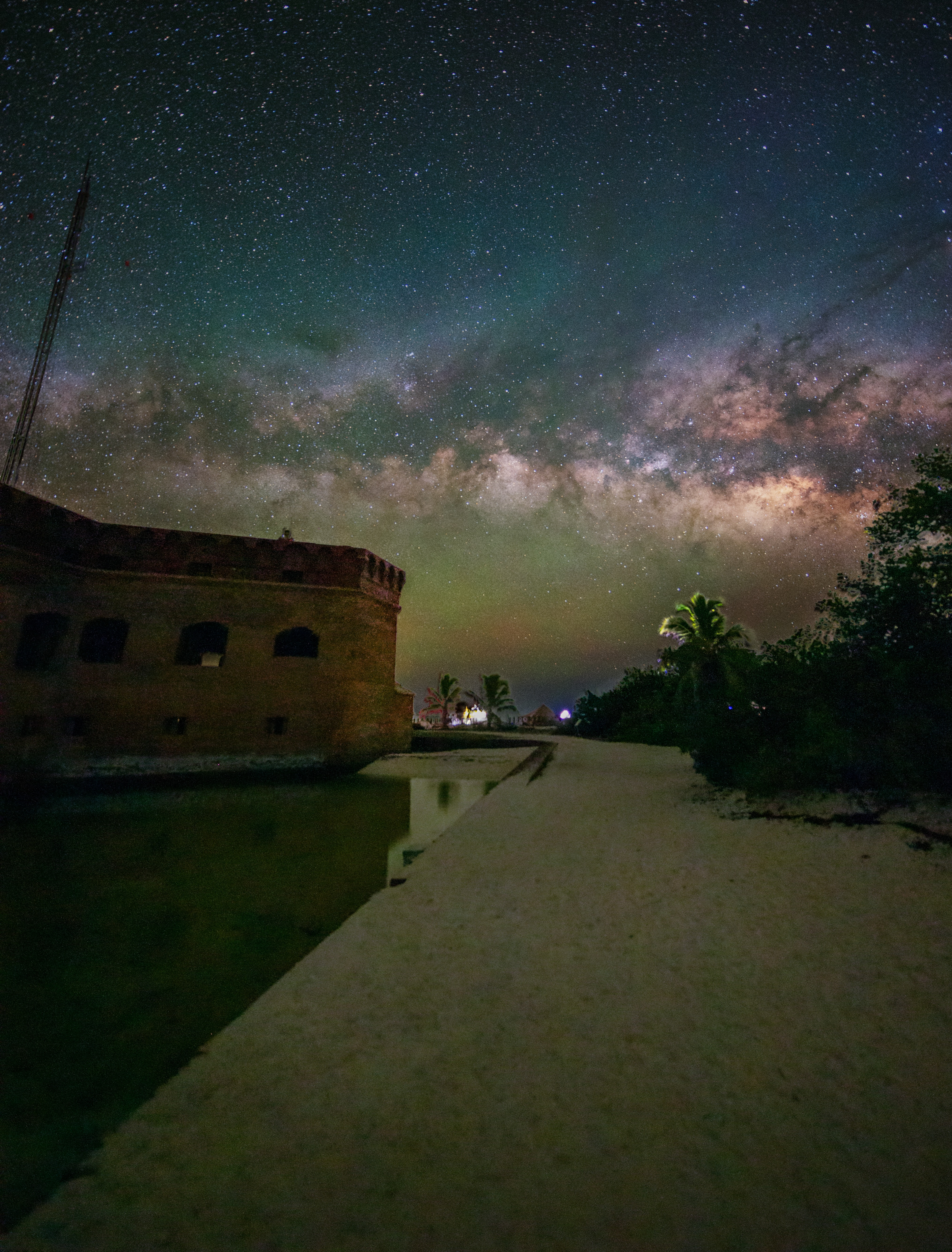
The Milky Way stretches above Dry Tortugas National Park in Florida.
Elkin Norena
Using those experiences, he became one of the original SLS team members. He was a part of the teams that successfully launched Artemis I and II and is now critical to the upcoming Artemis III mission.
Away from the launch pad, Norena’s hobbies orbit around his teenage daughters, participating in their activities. He also keeps a keen eye on space and is an avid astrophotographer.
“I love capturing the Milky Way! I’ve traveled to Utah, New Mexico, Arizona, and all across the western United States,” he said. “A great spot that’s closer for me is Dry Tortugas National Park beyond Key West.”
No matter how he explores space, Norena believes Artemis II is more than just a mission.
“This is historic. I grew up watching the shuttle missions, learning about Apollo, and wanting to be part of those Moon missions. We built the space station. The space shuttle explored space and technology on many levels,” he said. “Now, it’s our turn with Artemis to get back to the Moon, and this time to stay there. I’m excited to be part of the generation that does that.”
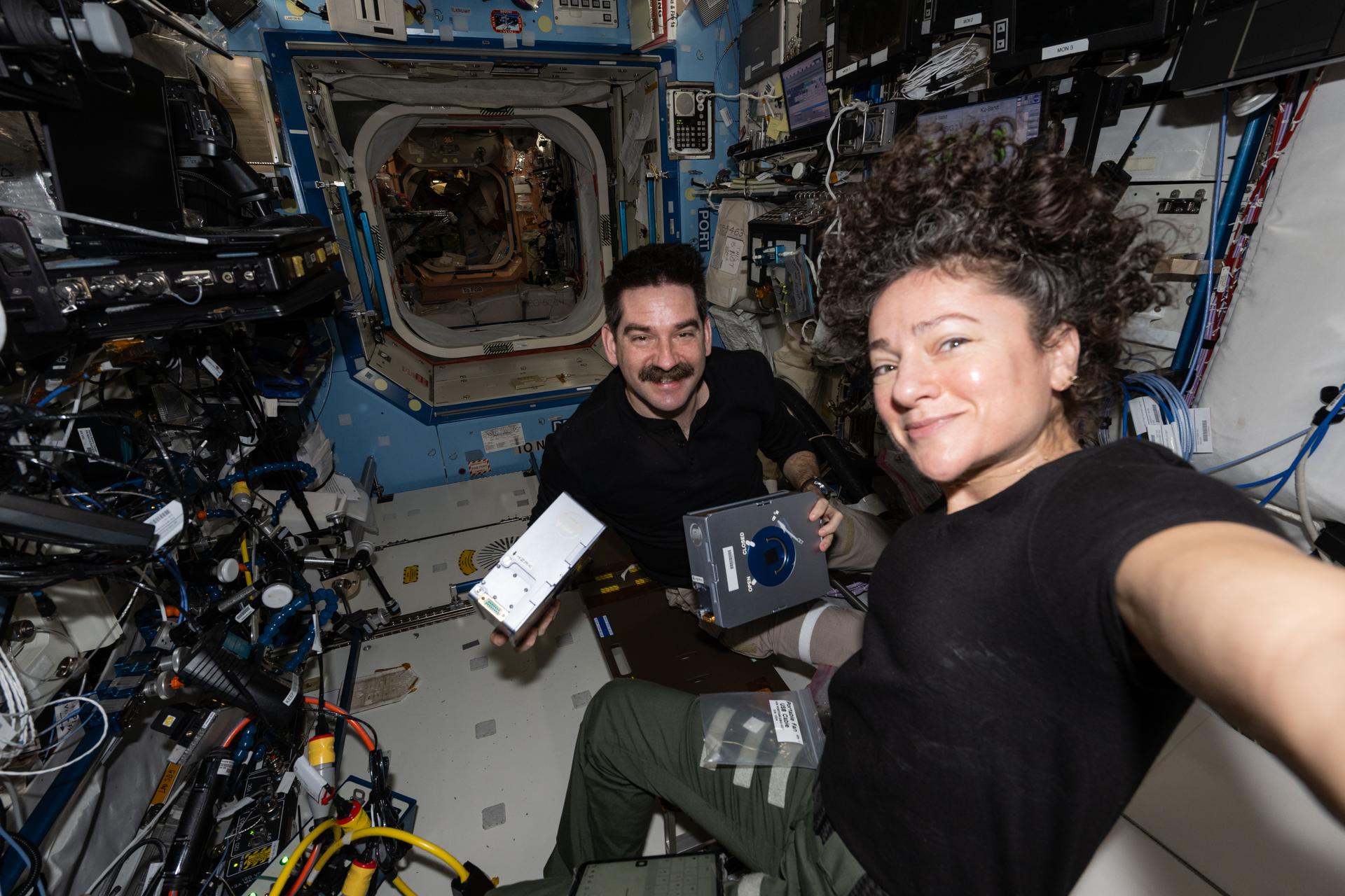
NASA astronauts Jack Hathaway and Jessica Meir pose together as Hathaway shows off a pair of Advanced Space Experiment Sample Processor-4 research cassettes being used to study how weightlessness affects drug crystal growth possibly leading to new pharmaceutical formulas.
NASA/Jessica Meir
Microbiology dominated the research schedule aboard the International Space Station on Thursday helping doctors protect health on Earth and in space. The Expedition 74 crew also tested a new spacesuit, packed a U.S. cargo spacecraft, and kept up lab maintenance throughout the orbital outpost.
Scientists are comparing bacteria samples grown onboard the orbiting lab to similar samples living in simulated microgravity chambers on Earth to learn how microbes respond to space-like conditions. ESA (European Space Agency) astronaut Sophie Adenot kicked off the Odyssey biotechnology investigation processing microbe samples inside the Kibo laboratory module’s Life Science Glovebox (LSG) to document their genetic function. Next, NASA flight engineer Chris Williams collected the microbes for preservation and cleaned the research hardware inside the LSG for continuing operations. Finally, NASA flight engineer Jessica Meir took over and completed the day’s genetic study treating the sensitive samples to observe their chemical response. She immediately stowed the microbes for preservation afterward inside the LSG’s science freezer that she had installed the day before. Insights gained from the new study may lead to new ways of protecting humans and equipment exposed to harsh conditions on and off the Earth.
After completing her microbe work, Adenot moved to the Columbus laboratory module and tried on a prototype spacesuit designed by ESA to be worn inside a spacecraft. She tested the EuroSuit for its ease of donning on and off, as well as its comfort and mobility, then documented her experience for engineers to review. Results will inform the final design of the suit to meet the ergonomic requirements of living and working in space.
Williams also continued packing cargo inside a SpaceX Dragon cargo spacecraft with assistance from NASA flight engineer Jack Hathaway. Dragon is being loaded with several thousand pounds of station gear and science experiments that will be returned to Earth for analysis by engineers and scientists. Hathaway spent the majority of his shift inside the Tranquility module swapping orbital plumbing components and transferring water between tanks for life support maintenance.
Meir began her shift servicing fluid-containing sample processing hardware that is supporting the observation of pharmaceutical crystal growth to promote the production of advanced cancer therapies in weightlessness. Next, she activated tubes filled with microbial and botanical samples for a variety of student-designed experiments inside the Harmony module.
Roscosmos cosmonaut and station commander Sergey Kud-Sverchkov inspected and cleaned ventilation equipment then repaired a thermal sensor inside the Zvezda service module. Flight engineer Sergei Mikaev disinfected surfaces inside the Zarya module and checked the functionality of video hardware. Flight engineer Andrey Mikaev spent his shift on orbital plumbing and oxygen generator maintenance in the space station’s Roscosmos segment.
Operations Specialist, Mars Exploration Program, NASA Headquarters
Operations Specialist, Mars Exploration Program, NASA Headquarters
Lane Painter is an Operations Specialist supporting the Mars Exploration Program at NASA Headquarters in Washington, D.C.
His work focuses on advancing innovative robotic mobility capabilities, next-generation commercial space models, and international engagement that support NASA’s robotic science exploration of Mars, with the goal of enabling greater science return and exploration capability at lower cost.
Painter is a co-lead for NASA’s Mars Exploration Program Science Transport and Robotic Innovation for Deployment and Exploration, or STRIDE, an activity focused on assessing and maturing emerging commercial mobility systems, including surface and aerial robotic systems, that could support future Mars exploration missions.
Painter also serves on the leadership team for the International Mars Exploration Working Group, or IMEWG, supporting NASA’s engagement with the multilateral forum of space agencies and government institutions focused on coordinating shared Mars exploration priorities. Through this work, he helps facilitate international dialogue on robotic Mars exploration, science priorities, technology development, mission planning, and long-term cooperation across the global Mars exploration community.
Prior to joining the Mars Exploration Program, Painter was part of the University of Chicago’s Human-Robot Interaction Lab, where he supported research at the intersection of robotics and human-machine teaming.
Painter earned a bachelor’s degree in economics from the University of Chicago and a master’s degree in Industrial Systems, Manufacture, and Management from the Department of Engineering at the University of Cambridge in the United Kingdom.
NASA Robotic Tech Demo Will Advance Prototype Gamma-Ray Detectors
A new type of gamma-ray sensor developed by NASA, called AstroPix, will take part in a robotic arm demonstration on the agency’s upcoming Fly Foundational Robots mission, set to launch in late 2027.
Gamma rays are the highest-energy form of light. Scientists observe them coming from events like lightning in Earth’s atmosphere, powerful solar flares from our Sun, and cosmic collisions in distant galaxies. The sensors on the AstroPix technology demonstration are designed to measure gamma rays between 20,000 and 700,000 electron volts. For comparison, visible light’s energy falls between 2 and 3 electron volts.
But for energies between 500,000 to 1 million electron volts, existing detectors are less sensitive. This range is where many powerful explosions called gamma-ray bursts shine the brightest. It’s also where astronomers expect to see the strongest glow from the most massive and distant active galaxies powered by black holes. By stacking AstroPix detectors in future missions, scientists could bridge this gap and improve observations of these cosmic objects to better understand the processes that create and drive them.
“The Fly Foundational Robots spacecraft is also a technology demonstration, so the projects were a good fit for each other,” said Dan Violette, an AstroPix team member and post-doctoral fellow at NASA’s Goddard Space Flight Center in Greenbelt, Maryland. “We need to thoroughly test AstroPix’s performance before we can use the sensors in future science missions. We’ve flown comparable technologies on a scientific balloon mission, and the current prototype eventually will be part of a sounding rocket payload. Many of those flight opportunities only reach near space, though. It’s not often that technology demonstrations like ours can find a ride into orbit.”
Each AstroPix chip has four silicon pixel gamma-ray detectors. Each of these detectors incorporates 1,225 pixels. AstroPix detectors, which are developed by NASA’s Goddard Space Flight Center in Greenbelt, Md., function similarly to the sensors in cellphone cameras except they are sensitive to gamma-ray light.
Image courtesy of Argonne National Laboratory
Each AstroPix chip contains four silicon pixel gamma-ray detectors, and each detector incorporates 1,225 pixels. The chips function similarly to the sensors in cell phone cameras.
The AstroPix Satellite Technology dEmonstration Payload, also known as A-STEP, will be hosted within the Fly Foundational Robots mission’s Orbital Replacement Unit, a movable module built by Rocket Lab Robotics. Rocket Lab Robotics also will provide a robotic arm that will pick up and reposition the unit during flight and perform in-orbit operations as part of a robotic servicing demonstration. The A-STEP payload will collect its data following the repositioning. Astro Digital will provide the spacecraft.
The Orbital Replacement Unit was designed to support power and data interfaces for a payload, but the original plan called for the robotic arm to reposition the module without one. As mission development progressed, however, the Fly Foundational Robots team identified an opportunity to further maximize the mission’s value by integrating an additional technology demonstration that could fit within the 11.8-inch (30-centimeter) cube.
“The unit already had the volume, power, and data needed to support the AstroPix team’s design,” said Bo Naasz, senior technical lead, In-space Servicing, Assembly, and Manufacturing in the Space Technology Mission Directorate at NASA Headquarters in Washington. “One of our major goals with Fly Foundational Robots is to demonstrate robotic changeout of payloads in orbit, enabling upgrades or improvements to satellites and space instruments at a fraction of the cost of a full mission. Allowing AstroPix to complete its own technology demonstration in orbit is a bonus.”
NASA’s Fly Foundational Robots mission will be hosted aboard a spacecraft provided by Astro Digital of Littleton, Colo., as shown in this artist’s concept. The robotic arm, provided by Motiv Space Systems in Pasadena, Calif., will perform a technology demonstration in orbit, including picking up and moving a small box containing the agency’s AstroPix gamma-ray sensors.
Rocket Lab Robotics
The AstroPix team is working to deliver their hardware this September, and it will be integrated into the Fly Foundational Robots payload before final integration onto the spacecraft. The Orbital Replacement Unit will hold the chips and all the associated electronics needed to provide power, and collect and transmit data during flight.
NASA’s Fly Foundational Robots mission is funded through the Space Technology Mission Directorate’s ISAM portfolio, managed at NASA Goddard. Rocket Lab Robotics will supply the mission’s robotic arm system through a NASA Small Business Innovation Research Phase III award. Astro Digital will host the orbital flight test of the arm through NASA’s Flight Opportunities program, managed at NASA’s Armstrong Flight Research Center in Edwards, California. The development of AstroPix was supported by NASA’s Astrophysics Division in the Science Mission Directorate at NASA Headquarters, through the agency’s Astrophysics Research and Analysis Program, and funded through the Nancy Grace Roman Technology Fellowship.
The origins and fate of massive compact objects such as black holes, neutron stars, and white dwarfs can only be fully answered by measuring deci-Hertz (dHz) gravitational wave emission. A plethora of innovative mission concepts have been proposed motivated by this need, promising incredible potential sensitivity and requiring substantial technical development. Like COBE rather than Plank, we optimize time to first knowledge over ultimate sensitivity. We describe the highest priority science goals contained in and motivating a dHz observatory, the minimum sensitivity required to make these observations, and the fastest, least-costly mission that meets these minimum requirements. We dub this mission the Deci-hertz Interferometer Space Antenna (DISA).
A soccer ball floats in microgravity in this March 2, 2026, picture from the International Space Station. The space station crew tested soccer balls to study how internal mass affects motion and stability in microgravity. The findings have improved understanding of how embedded technologies, including match-ball sensors, can influence performance during play.
NASA’s Career Technical Education Day Highlights Technical Careers
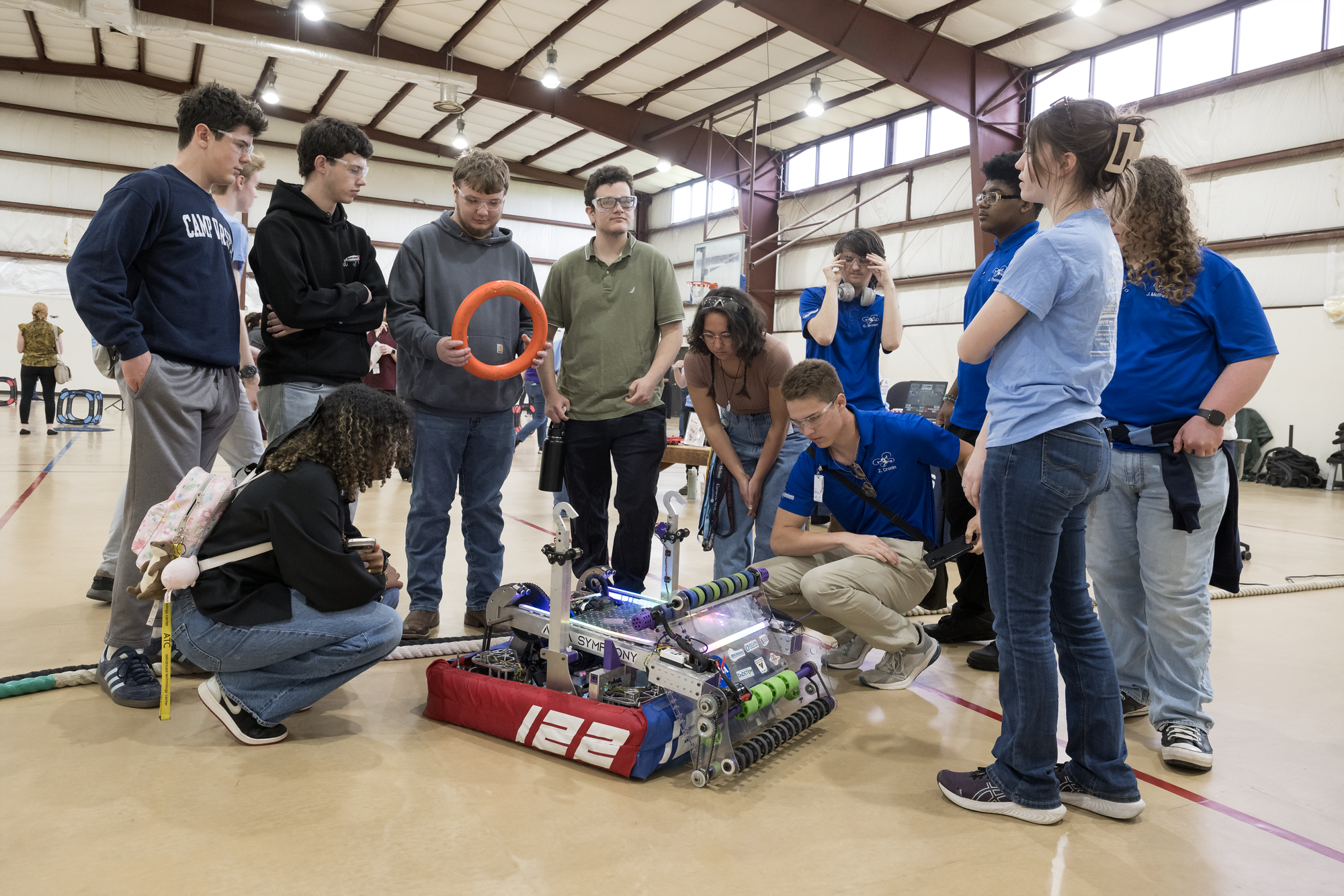
Students participate in a hands-on robotics demonstration during Career Technical Education Day at NASA’s Langley Research Center in Hampton, Virginia.
NASA/Mark Knopp
At NASA, remaining a global leader in exploration and innovation includes having a skilled and dedicated workforce. Technicians play a critical role in advancing the agency’s research and missions, applying hands-on expertise across engineering, fabrication, electronics, and countless other technical fields.
To help cultivate the next generation of technical talent, NASA’s Office of STEM Engagement hosted Career Technical Education Day recently at NASA’s Langley Research Center in Hampton, Virginia. One hundred high school and community college students from Virginia and North Carolina attended, eager to explore the technical career paths that help drive NASA’s work.
“Many students picture NASA as only astronauts or engineers and therefore never consider a career at NASA to be within their reach,” said Bonnie Murray, lead for the Office of STEM Engagement at NASA Langley. “Bringing students from local career and technical education programs to Langley allows them the opportunity to see technicians at work, hear the pathways those technicians followed, and understand how the skills they are developing in their related classes have a place in the NASA workforce.”
The event opened with remarks from NASA Langley’s Steve Gayle, who traced his path from an engineering technician co-op in the center’s Fabrication Division and a graduate of Langley’s Engineering Technician Apprentice Program to his current role as acting associate director. Gayle encouraged students to embrace challenges, think critically, stay curious, and create their own opportunities as they pursue their career goals.
“We need young, bright minds,” Gayle said. “At NASA, we rely on skilled hands-on professionals — technicians who operate our wind tunnels, apply their skills in our fabrication shops, and use their electronics knowledge to design, test, and build critical systems.”
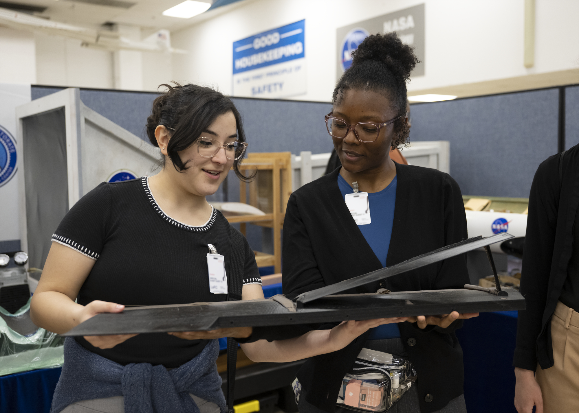
Students visit NASA Langley Research Center’s model shop during Career Technical Education Day to learn about the materials and techniques technicians use to build model aircraft and spacecraft.
NASA/Ryan Hill
Throughout the day, students toured several of Langley’s world-class facilities, including the historic Landing and Impact Research Facility and one of the center’s wind tunnels. At each stop, they received a behind-the-scenes look at the spaces where NASA technicians build, test, and refine the tools and technologies that support the agency’s missions. The technicians spoke with students about their work, their career paths, and the skills needed to excel in technical roles.
Hands-on demonstrations and interactive activities lead by NASA technicians and aerospace industry partners helped students connect their classroom experience with real-world applications. Whether observing fabrication techniques, seeing instrumentation up close, or engaging with engineering demonstrations, participants experienced how STEM and technical skills directly translate into meaningful careers.
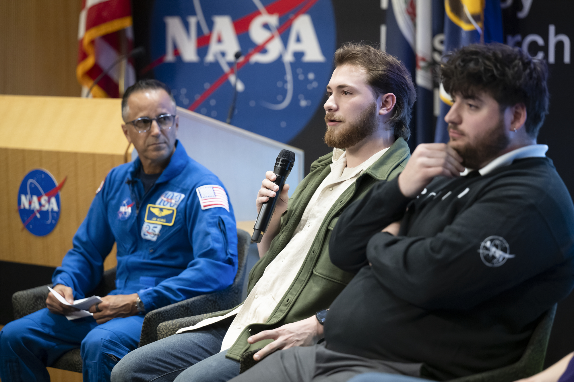
“Through events such as this, NASA seeks to prepare students for aerospace careers through experiences and investments that strengthen research capacity, build technical expertise, and expand reach in alignment with agency missions and needs,” Murray said. The event ended with a career panel moderated by NASA astronaut Joe Acaba, associate director of mission and strategy at NASA’s Johnson Space Center in Houston and former math and science teacher. The panel featured four Langley technician apprentices who shared insights into their roles and the value of strong foundational skills in technical fields.
Wyatt Healy, mechanical engineering technician apprentice at NASA’s Langley Research Center, answers questions during a career panel featuring NASA Langley technician apprentices during Career Technical Education Day.
NASA/Ryan Hill
“A basic grasp of how software, systems, and even everyday items function goes a long way as you progress in your technician journey,” said Wyatt Healy, mechanical engineering technician apprentice at NASA Langley. “When you have those fundamentals down, learning the more advanced concepts becomes much easier. It doesn’t happen overnigh but with a strong foundation, the sky is the limit.”
By connecting students with NASA professionals, facilities, and hands-on experiences, the event showcased a broad range of opportunities available in technical careers. It also underscored NASA’s commitment to building a strong, skilled workforce equipped to support the agency’s mission and tackle the challenges of tomorrow.
For more information about opportunities to connect students with NASA’s mission, work, and people, visit:
NASA’s Parker Solar Probe completed its 28th close approach to the Sun on June 8, again matching its record distance of 3.8 million miles from the solar surface. The flyby allowed the spacecraft to continue its measurements of the solar wind and solar activity at their source, while adding to our understanding of how the Sun’s atmosphere changes throughout the solar cycle.
The spacecraft checked in with flight controllers at the Johns Hopkins Applied Physics Laboratory (APL) in Laurel, Maryland — where Parker Solar Probe was designed and built — on Thursday, transmitting a beacon tone that indicated its systems were operating normally. Zooming around the Sun on a trajectory that limited communications with Earth, Parker had been out of contact and operating autonomously for nine days around its closest approach, as planned.
During this solar encounter, which started June 3 and ends Saturday, June 13, Parker’s four scientific instrument packages gathered data from inside the Sun’s atmosphere, or corona. Parker will begin returning detailed spacecraft telemetry on June 14, with science data transmission set to run from Wednesday, June 17 to Tuesday, June 30.
Parker’s observations of the solar wind and solar events, such as coronal mass ejections and the aftermaths of flares, are critical to advancing humanity’s understanding of the Sun and the phenomena that drive high-energy space weather events that pose risks to astronauts, satellites, air travel, and even power grids on Earth. Understanding the fundamental physics of space weather enables more reliable prediction of astronaut safety during future deep-space missions to the Moon and Mars.
Parker also equaled its record-setting speed of 430,000 mph — a mark that, like Parker’s distance to the Sun, was set during a close approach on Dec. 24, 2024, and matched during five flybys since, most recently on March 11. Parker will continue matching these speed and distance records during future flybys.
Through all six close approaches, mission leads say, the spacecraft has remained in excellent condition. While Parker doesn’t have a temperature sensor on the front of its heat shield — known as the Thermal Protection System, or TPS — the team can estimate through models that the heat shield reaches temperatures of about 1,700 degrees Fahrenheit at closest approach.
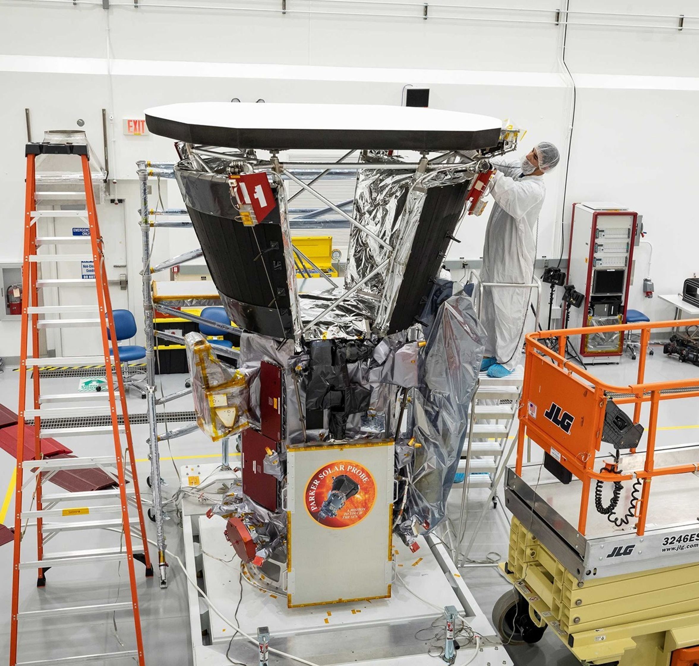
In this image from June 2018, about two months before Parker Solar Probe’s launch, technicians put the final touches on the thermal blankets below the spacecraft’s signature heat shield, the Thermal Protection System (TPS). After nearly eight years in space and through 28 solar en-counters, the TPS remains in excellent condition, even after withstanding temperatures of about 1,700 degrees Fahrenheit during its closest approaches to the Sun.
Meanwhile, the team can measure the temperature of the barrier blanketing below the heat shield, and the actual spacecraft temperature has remained consistent on each pass.
“That temperature consistency is a major indicator of spacecraft health,” said Wirzburger. “It tells us the heat shield isn’t degrading. If it were cracking or weakening, we’d see temperatures drift upward as more heat leaked through.”
Parker launched in August 2018. At the time, the Sun was near the minimum of its 11-year activity cycle. In 2024, representatives from NASA, the National Oceanic and Atmospheric Administration (NOAA), and the international Solar Cycle Prediction Panel announced that the Sun had reached its solar maximum period. Parker’s 28 encounters with the Sun reflect this change over time, sampling the Sun’s atmosphere from quiet to very active periods. Parker Solar Probe will remain in this orbit around the Sun and continue making observations into the declining phase of solar activity.
The next steps for the mission in late 2026 and beyond are under NASA review.
Parker Solar Probe was developed as a part of NASA’s Living With a Star (LWS) program to explore aspects of the Sun-Earth system that directly affect life and society. The LWS program is managed by the agency’s Goddard Space Flight Center in Greenbelt, Maryland, for NASA’s Science Mission Directorate in Washington. Johns Hopkins APL manages Parker Solar Probe for NASA and designed, built, and now operates the mission.
Mike Buckley, Johns Hopkins Applied Physics Laboratory
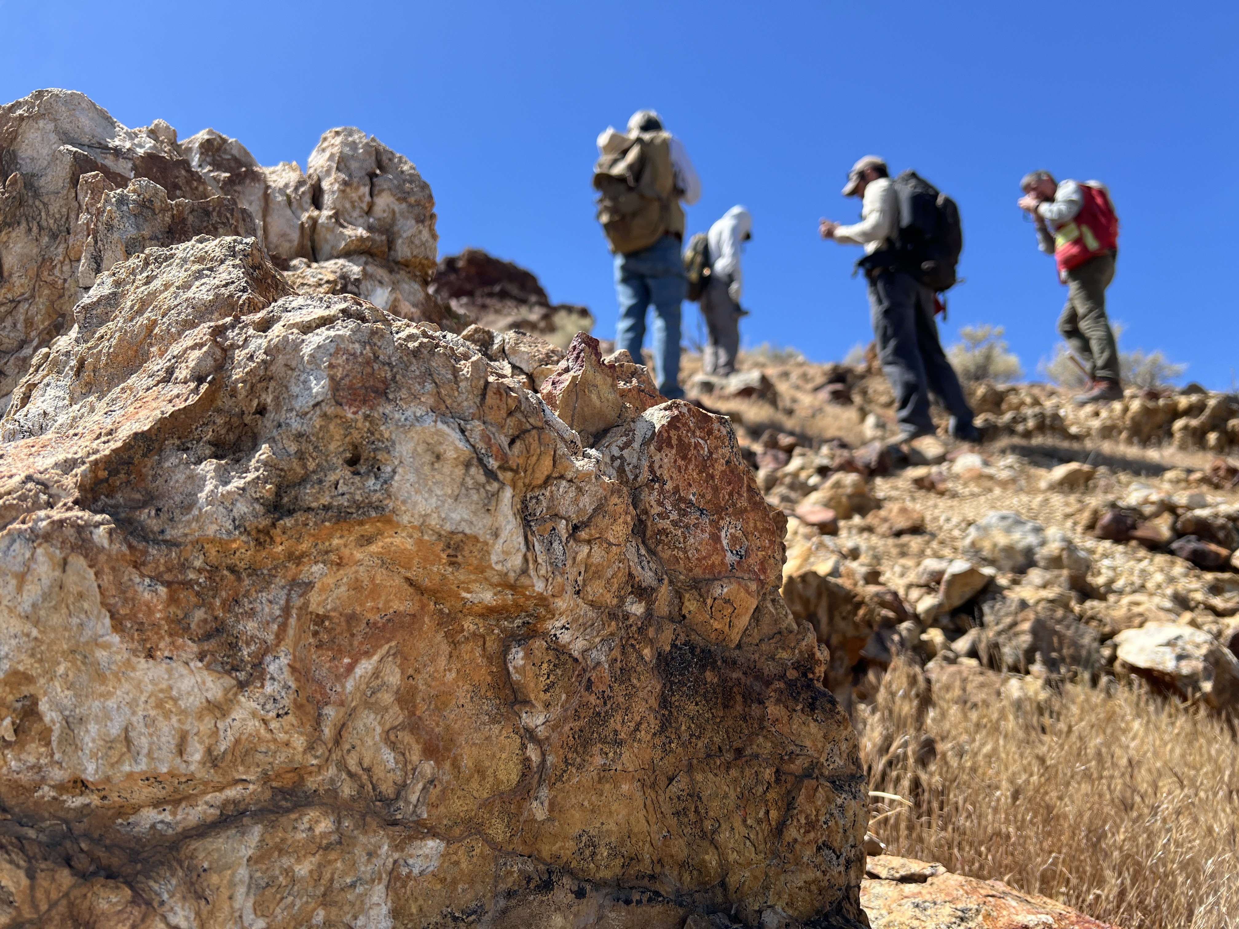
Geologists recently converged on a site near Barstow, California, to ground-truth a mineral discovery made on public land by a NASA JPL sensor flying aboard a plane overhead.
NASA/JPL-Caltech
Equipped with rock picks and hand lenses, a team of geoscientists deployed to the Mojave Desert recently to investigate a tantalizing “fingerprint” detected by a NASA sensor. Their target: a cache of topaz hiding in plain sight.
The geologists weren’t searching for gem-grade treasure. Rather, the presence of topaz could hint at a more valuable deposit below of something known as porphyry copper.
One of the world’s primary sources of copper, these deposits are left behind when magma and hot water from deep underground course through Earth’s crust, chemically transforming the surrounding rock. This tends to occur where one tectonic plate dives below another, known as a subduction zone, such as the North American Cordillera, which stretches from the Canadian Rockies to western Mexico.
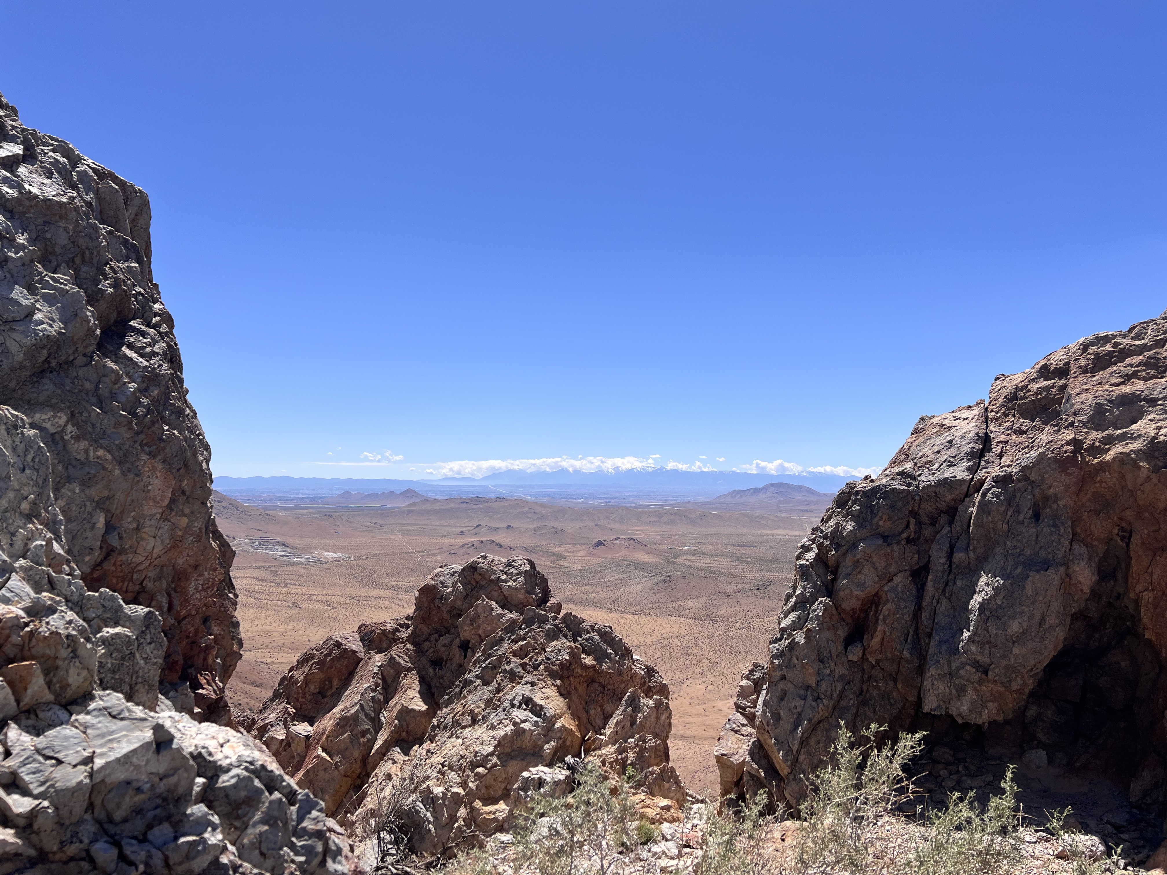
California’s high desert stretches below a bright spring sky in April 2026. NASA and USGS scientists are using airborne remote sensing to home in on potential sources of critical minerals here and across the Western U.S.
NASA/JPL-Caltech
In addition to copper — the third most used metal in the world after steel and aluminum — the deposits can hold other critical minerals like molybdenum and tellurium, which are used in everything from steelmaking to solar panels. Finding the deposits isn’t easy. Geologists look for topaz because it forms under the same volcanic conditions.
For the team in the Mojave, the goal was to collect more evidence. That would require boots on the ground and a heavy bag of samples. The scientists who converged on the site included three experts from the U.S. Geological Survey (USGS) and Robert Green of NASA’s Jet Propulsion Laboratory in Southern California.
“What we’re doing out here is geologic CSI,” said Green, referring to the investigative TV show, as he split open a weathered red rock to expose a sparkling core. “We’re looking for clues to reconstruct what happened here.”
Three-dimensional image cubes illustrate the volume of data captured by NASA imaging spectrometers. The front face shows an aerial view of the Mojave Desert. The colorful side panels reveal what no eye or camera can detect: the spectral fingerprints of minerals present in every pixel.
NASA/JPL-Caltech
Next-generation mineral mapping
The sensor that detected the topaz deposit on public land near Barstow, California, was built at JPL. Called AVIRIS, short for Airborne Visible Infrared Imaging Spectrometer, it analyzes reflected sunlight and can be used to identify chemicals and minerals by their unique spectral fingerprint. The technology was pioneered in the early 1980s by a team that included Green, and space-hardened versions have explored the Moon, Mars, and other rocky bodies in the solar system in the decades since.
While its cousins study distant worlds aboard spacecraft, the AVIRIS line of sensors is advancing Earth science from aircraft. The latest model, AVIRIS-5, recently took to the skies for the first time as part of the NASA-USGS Geologic Earth Mapping Experiment (GEMx). The goal of GEMx is to identify sources of critical minerals across the American West, including in the waste rock of active and legacy mines. It is led by the USGS as part of its larger, nationwide initiative.
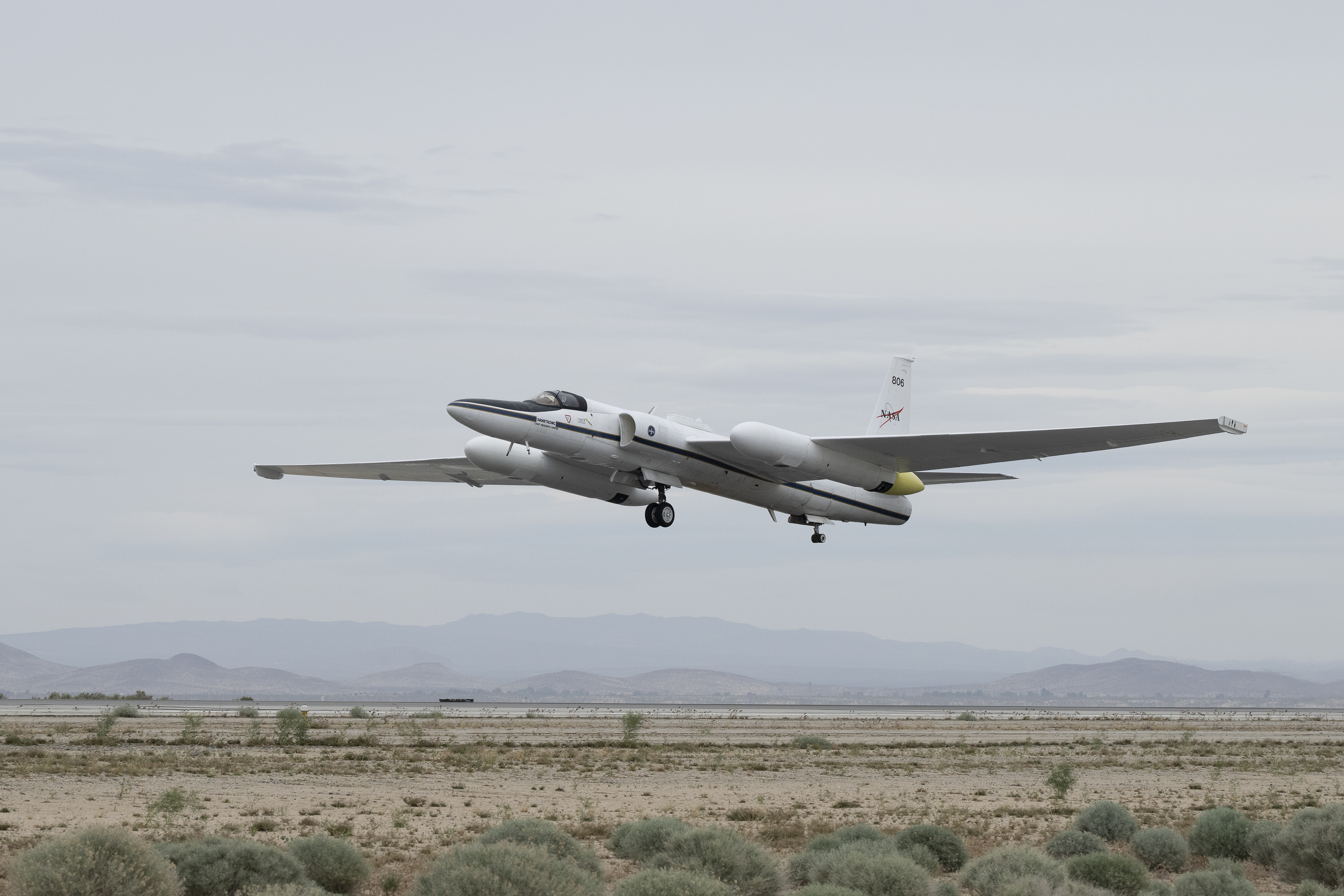
Carrying next-generation sensors, a high-altitude NASA ER-2 aircraft takes off from the agency’s Armstrong Flight Research Center in Edwards, California, on March 31, 2026, to support the GEMx mineral mapping campaign.
NASA/Carla Thomas
Since 2023, GEMx flights have covered more than 386,000 square miles (1 million square kilometers) of American soil, including most of California.
Ground-truthing the sensor data can entail hot field work, scrambling over steep crags to uncover samples for lab analysis. While testing has confirmed the topaz discovery, determining if the Mojave site overlies a porphyry copper deposit will require intensive investigation using ground-penetrating equipment. But the AVIRIS finding shows how advanced NASA airborne sensing can help lead geologists to the metaphorical needle in a haystack, even in heavily explored Southern California.
“People have been prospecting this area for generations,” said Erik Tharalson, a USGS geologist. “But there’s a lot more to discover.”
High flyer
From the beginning, the GEMx mineral mapping campaign has been enabled by one of the highest-flying aircraft in NASA’s fleet: the ER‑2. It deployed on March 31 from NASA’s Armstrong Flight Research Center in Edwards, California, to Colorado Springs Airport in Colorado.
“We deployed to Colorado Springs to maximize flight time for data collection needed in Colorado, Utah, New Mexico, Arizona, and Texas,” said John McGrath, ER‑2 project manager at NASA Armstrong.
By the conclusion of this deployment on June 5, the aircraft had completed 26 flights totaling more than 125 hours. Soaring at about 65,000 feet, the ER-2 can fly at high altitudes that allow it to collect broad‑area, high‑resolution spectral measurements in a single pass, supporting researchers studying mineral composition and surface processes.
In 2025, the aircraft flew 36 science missions, collecting more than 7 billion measurements over 200 flight hours. The data has contributed to the largest airborne surface mineralogy dataset gathered in a single NASA-USGS campaign.
The GEMx survey is led and funded by the USGS Earth Mapping Resources Initiative. Earth MRI is modernizing mapping the nation’s surface and subsurface to find new, critical, and other minerals. It is a partnership effort with 45 state geological surveys, federal agencies, private industry, tribes, universities, and others. The initiative will capitalize on both the technology developed by NASA for spectroscopic imaging, as well as the USGS expertise in analyzing the datasets, conducting field work, and deriving critical mineral information from them.
Katalyst Space’s LINK robotic servicing satellite awaits encapsulation inside a Northrop Grumman Pegasus XL on June 8, 2026, at NASA’s Wallops Flight Facility in Virginia. The rocket will carry LINK to space for an attempted orbital boost of NASA’s Neil Gehrels Swift Observatory.
Credit: NASA/Ron Beard
NASA will host an audio-only media teleconference at 11 a.m. EDT, Wednesday, June 17, to preview the Katalyst Space mission to boost the orbit of NASA’s Neil Gehrels Swift Observatory.
Katalyst’s robotic servicing spacecraft, called LINK, will attempt to rendezvous with Swift and raise its altitude, extending its science mission lifespan and advancing a key capability for the future of space exploration. The LINK spacecraft will launch on Northrop Grumman’s Pegasus XL rocket later this month from Kwajalein Atoll in the Marshall Islands.
Media interested in participating by phone must RSVP no later than two hours before the start of the call to Amy Barra at: amy.l.barra@nasa.gov. NASA’s media accreditation policy is available online.
Audio of the media teleconference will stream on the agency’s website at:
The Swift mission, which launched in 2004, leads NASA’s fleet of telescopes in studying changes in the high-energy universe, like gamma-ray bursts, which are the most powerful explosions in the cosmos. When a rapid, sudden event takes place in the sky, Swift serves as a “dispatcher,” providing critical information that allows other “first responder” missions to follow up to learn more about how the universe works.
After 21 years, Swift’s low Earth orbit has begun to rapidly decay because of increased solar activity. Rather than allowing the observatory to re-enter Earth’s atmosphere, as many missions do at the end of their lifetimes, NASA is using this opportunity to advance U.S. spacecraft servicing technology. In September 2025, NASA awarded a contract to Katalyst to mount a robotic servicing mission for Swift in less than a year. The mission will use LINK to rendezvous with Swift and boost it to a higher altitude, demonstrating a key capability for the future of space exploration. The mission is targeted for launch in June from Kwajalein Atoll, Marshall Islands.
Learn more about the mission to boost Swift’s orbit at:
TEMPO detected high concentrations of nitrogen dioxide during the morning commute at 7:05 a.m. local time on May 18, 2026 (left), along the New York-Washington corridor. The instrument detected lower levels of the gas at 3:05 p.m. (right), after chemical reactions involving nitrogen dioxide had contributed to elevated ozone concentrations in the afternoon.
NASA Earth Observatory/Michala Garrison
7:05 am
3:05 pm
TEMPO detected high concentrations of nitrogen dioxide during the morning commute at 7:05 a.m. local time on May 18, 2026 (left), along the New York-Washington corridor.The instrument detected lower levels of the gas at 3:05 p.m. EDT (right), after chemical reactions involving nitrogen dioxide had contributed to elevated ozone concentrations in the afternoon. NASA Earth Observatory images by Michala Garrison.
More than 35 million people live along the New York–Washington corridor and breathe the region’s air. While air quality has improved significantly in recent decades, outbreaks of ground-level ozone remain common, particularly in the warm summer months, when the chemical reactions that produce the pollutant accelerate and stagnant air allows ozone to accumulate.
A reminder of this seasonal phenomenon came earlier than usual in 2026, when a mid-May heat wave prompted the New York State Department of Health and the New York Department of Environmental Conservation to issue a health advisory on May 17 over concerns about ozone. The code orange advisory warned young people, older adults, and those working or exercising outdoors to limit activity due to ozone’s respiratory and cardiovascular health impacts.
As expected, ground-based air-quality sensors operated by state and federal agencies showed ozone reaching unhealthy levels for sensitive groups on May 18, something that typically happens several times per year. Meanwhile, NASA’s TEMPO (Tropospheric Emissions: Monitoring of Pollution) instrument observed the event from geostationary orbit 22,000 miles (35,000 kilometers) above the equator, a unique vantage point that allows the sensor to collect frequent observations of air pollution.
TEMPO detects nitrogen dioxide (NO2), a gas emitted by burning fuels, particularly by motor vehicles, that contributes to ozone formation. “There’s often a clear and interesting pattern in TEMPO’s nitrogen dioxide data during ozone alert days,” said Hazem Mahmoud, an atmospheric scientist at NASA’s Atmospheric Science Data Center at Langley Research Center. “We see high concentrations of nitrogen dioxide during the early morning commute that drop off sharply in the late afternoon as ozone increases.”
The decline occurs as sunlight fuels photochemical reactions involving nitrogen dioxide, volatile organic compounds, and oxygen that lead to ozone formation. By late afternoon, these reactions deplete much of the available nitrogen dioxide, slowing ozone production until the cycle begins again the next day.
The pair of images above underscores the pattern. The image on the left was acquired at 7:05 a.m. local time when nitrogen dioxide concentrations were high during the morning commute. By 3:05 p.m. (right), most of the nitrogen dioxide had declined substantially, and surface ozone levels were elevated (below). Meanwhile, afternoon sea breezes appear to have transported the remaining nitrogen dioxide slightly to the west. Note that the data shown is provisional, and processing methods are still being refined.
Sensors on earlier polar-orbiting satellites, such as OMI (Ozone Monitoring Instrument) and TROPOMI (Tropospheric Monitoring Instrument), sampled nitrogen dioxide over New York once per day. After its launch in 2023, TEMPO began providing data every hour, allowing researchers to track the evolution and dispersion of air pollution at much finer time scales.
“TEMPO is helping fill data gaps between ground stations and allowing us to ask new questions,” Mahmoud said. The mission provides data that can improve not only air quality forecasts during crisis situations, such as wildfires, but also the atmospheric models used to forecast the daily rhythms of urban pollution. Such models help researchers understand how natural factors such as winds, humidity levels, and air temperatures influence pollution plumes over the course of a day.
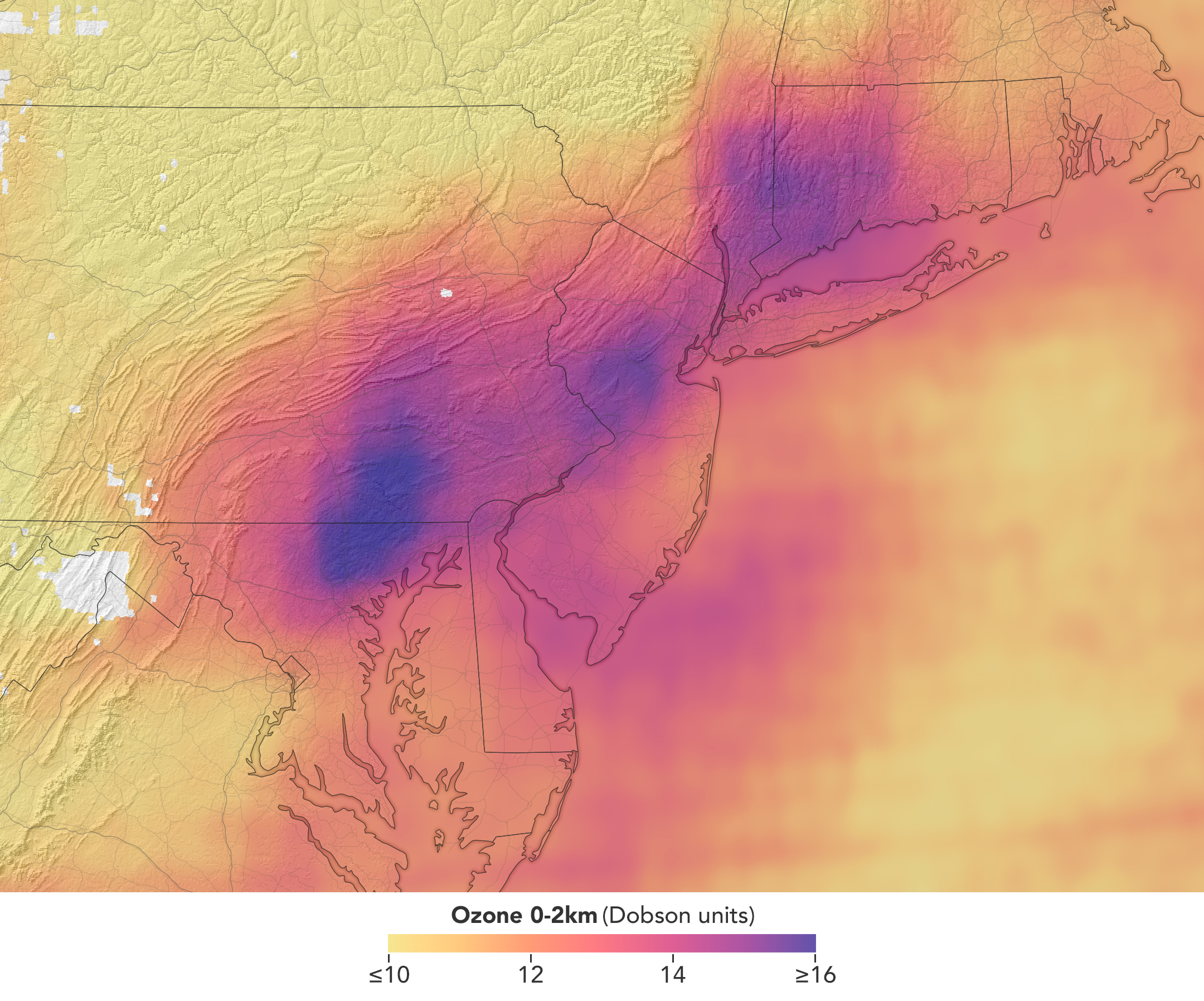
TEMPO detected elevated ozone concentrations in an area extending from New York City to Washington, D.C., at 5:05 p.m. on May 18, 2026.
NASA Earth Observatory/Michala Garrison
TEMPO also detects ozone directly, but determining how much of that ozone is near the surface versus higher in the atmosphere can be challenging. Most of Earth’s ozone resides in the stratosphere, well above the troposphere, where people live and breathe. At times, however, stratospheric ozone can be transported downward into the troposphere. During events known as stratospheric intrusions, it can even descend far enough to affect air quality at the surface and add to the ozone produced at ground level.
By combining TEMPO observations with other sources of information, researchers are studying the processes that influence the distribution of ozone vertically in the atmosphere. On May 18, NASA’s ground-based tropospheric lidar network (TOLNet) in New York City recorded high concentrations of ozone near the surface, indicating that TEMPO was detecting mostly surface-level ozone associated with urban emissions and not ozone aloft, said Mahmoud.
However, on May 19, the same sensor observed a layer of ozone descending from above 5 kilometers (3 miles), he added, a clue that some of the ozone TEMPO detected that day may have originated in the stratosphere. “This is the type of information that leads to better air quality forecast models and more accurate alerts,” Mahmoud said. “Alerts can affect tens of millions of people and lead to disruptions in school, sports, and other activities, so it’s essential that they be as accurate as possible.”
On June 6, New York authorities issued another health advisory for ozone. People interested in following the event can access daily near-real-time TEMPO observations of ozone, nitrogen dioxide, and other gases on NASA’s Worldview browser, on an interactive Harvard & Smithsonian Center for Astrophysics browsing tool, and on NASA’s Earthdata portal.
NASA Earth Observatory images by Michala Garrison, using TEMPO data from NASA Earthdata.Story by Adam Voiland.
Crews at NASA’s Marshall Space Flight Center in Huntsville, Alabama, install a flight reactor engineering development unit into Test Stand 400 in preparation for cold-flow testing. The test campaign began in July and ran through September and marked the first testing on a flight reactor engineering development unit since the 1960s. Credit: NASA/Adam Butt
Host Andres Almeida: Nuclear propulsion engineering could play a key role in sending spacecraft to deep space, enabling faster and farther journeys for robots and humans. How does it work? How safe is it? And how have we applied lessons from the past to shape the future of exploration?
Kurt Polzin, chief engineer for the Space Nuclear Propulsion Office at Marshall Space Flight Center, is here to tell us. This is Small Steps, Giant Leaps.
[Intro music]
Welcome to Small Steps, Giant Leaps, the podcast from NASA’s Academy of Program/Project and Engineering Leadership, or APPEL. I’m your host Andres Almeida.
This is an exciting topic, so let’s get into it.
Host: Hi, Kurt, welcome.
Kurt Polzin: Thank you.
Host: What is space nuclear propulsion and why is NASA investing in it?
Kolzin: Sure. In nuclear energy for propulsion, and even for power, there’s nothing magical about it. A lot of people think nuclear and they think this big kind of, kind of very “black box,” you know, very hard to understand concept.
But really, nuclear power, it’s just a source of heat. It’s a very big source of heat. It’s a very high-density source of heat.
You know, in our project, when we talk space, nuclear propulsion and power, we’re normally talking about fission systems. So, taking uranium atoms and breaking them apart into their, you know, constituent atoms through that process, as opposed to radioisotope, where you take, say, plutonium and it falls apart over time.
Fission is really critical because it’s scalable. It’s high-power density, it’s scalable, and it provides us with a couple of really key things that are really important for working in space.
One: Very high power on demand. I can get high power, I can get it quickly. And the second is power where other power sources may not be useful or may not be big enough.
So, for example, in the shadows, like on the Moon when it’s in shadow or when you’re very far from the Sun, these are areas where nuclear really shines.
And it’s why NASA is investing in it, because what it allows us to do then is consider missions and applications that you simply can’t do any other way.
And I like to talk about in an analogy to, like, the nuclear Navy.
We have nuclear aircraft carriers and nuclear submarines. Well, why do we have those? Well, because we had diesels, but diesels were limited. You had to pull up oilers to fuel them. You had to come up with your submarine every once in a while to exchange the air.
Nuclear allowed those submarines to stay underwater indefinitely. They allow aircraft carriers to go on for months at a time without needing refueling for the ship itself.
And so, you know I asked my team, “What are the analogies for us? What are the things you can do with nuclear that you just can’t do any other way?”
And that’s the reason why NASA is investing in it, because there are real applications that nuclear can do certain things, do certain missions that you just can’t do any other way.
Host: And it differs in chemical propulsion where the supply is…
Polzin: Oh, absolutely. So, chemical propulsion, the energy for the propulsion system is stored in the chemical bonds, right?
I need a fuel and an oxidizer. I need some kind of chemistry there to break those bonds, release that energy in the form of heat. And then I take that hot gas and I accelerate it out a nozzle to generate thrust.
In nuclear, I’ve decoupled my power source, which is now nuclear, from my propellant choice. So, I can choose a much more optimal propellant.
In this case, it turns out that for a thermal engine, hydrogen is very good. So, I could take hydrogen, for example. I can flow it through a nuclear reactor and I can get very, very hot gas coming out the other end, which uses the propellant more efficiently.
Now, there’s a bunch of gas dynamics and physics reasons for that, why hydrogen is the best propellant. I’m not going to get into those, but if I can use pure hydrogen, very low molecular weight product coming out the end, it turns out there are real advantages to that.
On the other side, I can take that heat and I can generate electricity and I can use those to power electric or plasma thrusters, if you will. And I can use applied electric and magnetic fields to accelerate a plasma out of my engine at very, very high velocity (use my propellant very, very efficiently).
But all these are enabled because I have an independence of choice because my power source is no longer tied up with the chemistry of the propellant I have to choose.
Host: And that supply, that nuclear supply is longer lasting, typically?
Polzin: Yes, absolutely. It’s much longer lasting. Really, it’ll last as long as you design it to. It is limited by the nuclear process.
Obviously, at some point, you will fission enough of the system where you won’t have enough uranium there anymore to support criticality, but that could be a very long time. I mean, we have submarines that are going for years and years and years before they need to do any servicing or refueling.
Host: What lessons from earlier efforts are being applied to the work we’re doing today?
Polzin: Yeah, so there’s several, actually. If you go back even, although, I mean, we’ve been talking about doing nuclear propulsion and power since the 1950s seriously.
From that time forward, we’ve had a lot of things we’ve learned, lot of challenges that we’ve encountered. How do you develop these materials? These materials are different than what you would have in a terrestrial reactor.
And so, we’ve had to figure out how do those materials behave in this environment? How do they behave under these conditions? You know, the reactor for space runs a lot hotter than it does for a terrestrial nuclear reactor. And there’s reasons for that. There’s reasons why it has to run hotter in space.
But because of that, the nuclear fuel that you have to use, the materials of the core itself, the ability to shield that reactor and do it in a lightweight manner, right? I can’t just pour lots and lots of concrete around it if I’m trying to fly it in space. Mass is at a premium for us.
These things are all really, really critical in terms of developing these systems. And getting them light enough mass to be able to actually realize a competitive and realistic system.
We’ve taken in our project a nice iterative stepwise approach. We said, “There are certain fundamental problems that have remained unsolved. Let’s go solve those. Let’s go look at the fuel, the fuel chemistry, the materials at the most basic fundamental level because it’s great if I can build something really big, but if it’s not going to survive when I expose it to these conditions, then it’s no good, right?”
So, let’s build it at a small level. Let’s make sure that we’re crawling before we walk, we’re walking before we run, but that we’re doing the hard work, right? That we’re doing the hard work that will get us not just a capability that’s part of what we want, but that’s actually the full spectrum of what we want and what we need to really, as I said earlier, to do missions that are just not otherwise possible without nuclear.
I’ve liked to pull in expertise from other areas, (technologies and developments, that weren’t necessarily developed for this application, but that can be applied really, really well to it with just a little bit of a push.
One example is the electric aircraft work that NASA is pursuing, right? You have these aircraft, you’re putting, pushing, you know, high levels of power, high levels of current across an airframe.
Well, that looks a lot like a nuclear electric system in that I’m pushing high levels of power, high levels of electrical current across a spacecraft. And so, are there components and subsystems I’m developing for this aeronautics project that can be applied to this space project?
And so, looking at where those synergies are, even if they weren’t developed for the space nuclear application, being able to apply it to it with, like I said, just a little bit of an extra push.
And finally, we don’t necessarily have to require that our initial systems are the best. We kind of get into a trap here a little bit of saying, “You know, this first nuclear system, it’s gotta be the best. It’s gotta be better than anything that it’s competing with.” And I don’t think that’s right.
You know, I think that in order to make progress, you need to feel the system that’s reasonable, but that has a reasonable path to further improvement.
I like to point to SpaceX and Falcon 9 just because it’s a really good recent example of this. Falcon 9 is not the same rocket today that they first flew on that first mission. They’ve improved it, they’ve block-upgraded it, they’ve increased its capabilities over time to make it what it is.
And I see kind of a similar thing for space nuclear power and propulsion. You want to field something, get experience with it, and then as you get that experience, block-upgrade it and make it better.
Host: what are some of the milestones that that have happened recently over the past couple of years that don’t get the headlines?
Polzin: Sure. And we’ve had quite a few actually.
So, one of the things that we’ve done recently, in fact (and this did get a press release, this was in the headlines), We did a cold flow test campaign for many months here at the Marshall Space Flight Center. That was all brought about because in the 1960s, some of the nuclear thermal propulsion systems, these are the ones where the flow would go through the reactor and pick up the heat directly.
They would be subject to uncontrollable and catastrophic vibration. We call this flow induced vibration because even without the heat source on, just the flow itself would cause the reactor to shake. (This, obviously) Not good.
And so, for more recent designs, we had done a lot of analysis of various designs to see: Are these susceptible to the same failure mode? But nothing substitutes for a test.
And so, we had a test article built that we ran out at the Marshall Space Flight Center test area to see if we were in fact safe from this flow-induced vibration phenomenon. And we were, right?
So, it turned out that we were able to confirm our design tools and our analysis and show that, in fact, we are able to capture really well with our analytical and modeling tools the phenomenon that are happening. But also…
Host: Did you do these tests also in collaboration with Department of Energy and other organizations?
Polzin: So, sometimes, and we have some other successes here where we have done tests with other agencies.
For example, we’ve been developing nuclear fuels for these NTP [nuclear thermal propulsion] engines. They’re really hot. You know, we’re talking the propellant has to get to 2,700 degrees Kelvin, which means the nuclear fuel has to get even hotter to be able to push the heat into the fuel. That’s really hot for any kind of nuclear fuel.
We’ve gone through multiple iterations with Department of Energy, several of our industry partners, our colleagues at other NASA centers, trying to develop these nuclear fuels and the other materials you would need inside a reactor to build that system.
And a few years ago, I wouldn’t have been able to make this statement: But at this point, given where we are and given the multiple iterations and multiple formulations we’ve tried, we have finally hit upon a few separate paths, a few separate fuel candidates that, through preliminary tests, at least show they will survive that really, really high temperature environment.
And oh, by the way, they’re exposed to hydrogen, which is very, very corrosive to materials at really, really high temperature. And so not only to survive the temperature, they’ve got to survive the chemistry and chemical attack of that environment.
And so, this work has really allowed us to develop these materials. We don’t get a lot of press on this because we don’t talk about it as much in the in the popular literature. Certainly, it’s in the scientific literature, but in the press, for example, this doesn’t get as much play.
But it is a really big deal to be able to solve what were in fact longstanding problems from the 1950s and 1960s, it had gone on for that whole time between then and now.
We had a big lithium-fed MPD thruster test that stands for magnetoplasmadynamic. This is a very high-powered plasma thruster. We funded JPL to build a first test unit. It’s the first real domestic work in this area at that power level in at least 15 or 20 years.
And they recently had their first successful firing of that thruster a couple months ago. So, we’ve made some real progress in some real key areas.
Host: This might be a jump, but we send plenty of spacecraft that have plutonium, correct? That’s their main power source.
Polzin: We sure do. That’s right.
Host: Are we taking lessons from that as well?
Polzin: So, to some extent, the difficulty there, and this was a challenge for me to, because I originally thought that from a safety basis and from ah an integration standpoint, there’d be a lot of overlap between those two.
It turns out there’s not as much as I had hoped. There’s some, but not as much as I would hope. The difficulty, the challenge is plutonium is starting to produce power and is starting to be radioactive. Basically, from the moment you make it, it’s starting to decay.
Host: Right.
And as it decays it’s transforming into a different element. It’s releasing neutrons. It is creating heat. But it’s radioactive from the moment it’s made, right? Because it is a man-made element in the first place. And so, that’s very critical in terms of how you handle it.
It’s also typically one of the last things integrated into a spacecraft, right? So, the entire spacecraft is built, and then at the last moment, the plutonium source is integrated before it’s launched. It’s really the heart of the spacecraft. It is part of the spacecraft. And so, everything kind of has to be assembled around it.
So, when you get especially to integration, the reactor is going to go in there. It’s going to go in early because a lot of things are going to be connected to and hanging off of it. And because of that, you’re going to have people in the presence of the reactor for a much longer period of time during that whole integration process.
Now, the good news is that these reactors are not radioactive until we turn them on. So, throughout that whole integration process, it’s still very, very safe because it’s never been turned on. It’s not radioactive. You can approach it very safely until you actually start that nuclear chain reaction, which we don’t plan to do until we get off the Earth and into what’s called a nuclear safe orbit, which is essentially an orbit where that spacecraft is never coming back to Earth.
Only then would we turn it on and start to generate, you know, radioactive products in the reactor. So, in some respects, it’s much safer in terms of being able to be exposed to the reactor because it’s essentially a dead weight until you turn it on.
Host: So, what are we looking forward to in this next couple of years? Artemis III is getting ready. What are we looking forward to in terms of development?
Polzin: So, obviously, you know, we had the Ignition event a few months ago with the administrator. And since then, the space reactors office is being stood up. SR-1 was announced at the Ignition event. LR-1, which is Lunar Reactor 1, as opposed to Space Reactor 1, which is SR-1, have both been announced within the next four-year timeframe.
LR-1 is very interesting. It is a power system for the lunar surface. It is going to leverage a free-flying power and propulsion system in SR-1, but nuclear is really key for a sustained lunar presence.
You have 14 days of night in pretty much every location on the Moon. It’s very, very cold. There’s been whole problems, whole issues with what’s called survive the night because it is so long and it is so cold.
And so, having nuclear power is really enabling for having a sustained presence anywhere. Just in general, having an excess of power is enabling for a lot of things.
But to be able to keep your instruments warm to make sure they don’t freeze up, to have enough power to sustain human presence, to sustain the work they’re going to be doing, it’s really, it’s almost very critical to that path.
Obviously, we’ve landed on the Moon back in the ‘60s and ‘70s. Those were very short stays, and those were all pretty much in sunlight.
We’ve left some radioisotope systems behind as instruments, but those are all very, very small things. So, if you want to do something that’s big, that’s meaningful, that’s new, you really, you really are talking nuclear to be able to enable you to have kind of global presence on another planetary body.
And then you look forward beyond that, right? A lot of those technologies are going to be useful and applicable when you go beyond that to Mars, right?
So, it is very, very useful to use the Moon as a proving ground for a lot of these technologies.
And it has its own utility in its own right on the Moon as well. I don’t want to say that the Moon is just a proving ground for it. It is very useful for that as well.
Host: Yeah. So, Kurt, on a personal level, what was your giant leap?
Polzin: So, this is an interesting question. So, when I first got to NASA, I was kind of wet behind the ears (just finished PhD) when I first got started here at NASA. I was in the lab, was publishing papers, was getting to be recognized in my technical community.
But it was really when I started to get beyond my technical community a little bit, I started to get involved in my professional society as a volunteer and as a volunteer leader. And at that time, or around that same time, because I started to make connections with people that I wouldn’t have otherwise connected with in my in my regular day job,
I started to notice my profile rising. I started to notice that I was getting invited into meetings and into discussions that I wouldn’t have otherwise been invited to, and that my opinion was starting to be asked about various topics, sometimes beyond the scope of what I was working on.
And then other positions started to become available. You know, the position I had before this, the position I’m in now, these were not necessarily things – it’s not that they were necessarily hidden, it’s just that I was more actively sought out to apply for them.
And so, that was the really the big switch, is when all of a sudden I started to get invited into those rooms that I might not have otherwise been invited into and started to have people well above what was my level asking my opinion and taking it very seriously.
That’s kind of when it hit me that, you know, I had made a transition in my career. I was no longer just somebody toiling in the lab doing research and development in my field. I was starting to become more of a visible leader in the field. And that was a big switch for me.
That was kind of where something flipped where I realized this is different, right? This is new. And so, I would say that more than anything else was really my big, giant leap, if you will.
Host: That’s great. Well, thank you, Kurt. We’re looking to the future of space nuclear power of propulsion.
Polzin: Alright, thank you.
[Outro music]
Host: That’s it for this episode of Small Steps, Giant Leaps. For a transcript, and for all other episodes, visit nasa.gov/podcasts. While you’re there, check out our other podcasts like Houston, We Have a Podcast, Curious Universe, and Universo curioso de la NASA. As always, thanks for listening.
Curiosity Blog: Sols 4913-4919: Planetary explorers, freewheeling to the Yardang unit!
Navcam image from sol 4916 showing the rough drive direction. The yardang unit can be seen as a series of pale coloured hills in the centre of the image, at the very back.
NASA/JPL-Caltech
Written by Catherine O’Connell-Cooper, APXS Strategic Planner and Payload Uplink/Downlink Lead, University of New Brunswick, Canada
Earth planning day: Friday, June 5th, 2026
In a very broad sense, Curiosity has two modes of doing science – one centred around a defined science campaign (such as the recent boxwork campaign) and the other as we move between campaigns. During a science campaign, with a very defined start and end location, every image and every workspace is carefully choregraphed to make sure we hit all of our science goals for the campaign. This is a lot of pressure!
But in between campaigns, the emphasis moves to driving towards the next major campaign. Our next major stop is the yardang unit, a series of intriguing wind sculpted, pale coloured hills which you can just see in the distance in the cover image for this blog. The rover planners (RPs) sometimes make our drives as long as they can and we drive as far as we can go, other times we stop a little short to look at interesting looking workspaces as we go. As part of the APXS team, I loved being part of the boxwork campaign and getting all the information we needed there … but as a geologist, there is something very special about this kind of exploring, the sense of being a planetary explorer, ambling along to see what the rocks will show us.
So we continue southwards, trundling over laminated bedrock which varies from predominantly pale coloured laminated bedrock to bands with abundant thin flaky, darker coloured, layers and patches. Some of the rocks stick out at strange angles, which make planning drives more challenging. This past week there has been abundant dark layers interbedded with the more dominant pale coloured rock, both in place and in fragments around the workspace. APXS and MAHLI characterized some of this darker material, for example at “Rio Bio Bio” and “Placilla de Caracoles” and some of the paler material at the brushed targets “La Primavera” and “Los Quemados.” ChemCam also analyzed both types of rocks along the way.
We are busily acquiring Mastcam and ChemCam LD-RMI (“Long Distance Remote Micro Imager”) images of everything even remotely interesting – and there are lots and lots of cool features around here. The wide open landscape here allows us to image features from several different angles and distances, such as “Mira Flores,” a small erosional outlier seen from a distance in this image and closer up here. Another great example is the “Kimsa Chata” trough which shows some amazing sedimentary structures, which may help us to determine if this was a desert or a lake or maybe something in between, such as a desert with some water moving through.
The Environmental Theme Group continues to populate each plan with environmental monitoring activities. Activities varied from dust devil monitoring in Gale crater to looking at levels of dust in the skies overhead. The weekend drive is planned to take us further into that drive distance shown in the cover image, to an area where the contrast between dark and light bedrock is more pronounced, and just beyond that, to an area which looks very smooth, with no jutting out blocks. From where we sit today, its impossible to say what it is but that is the fun of exploring – who knows what we will find? Stay tuned to find out over the coming weeks.
NASA has selected multiple small businesses for the Western Regional Multiple Award Construction Contract, which supports a broad range of facility enhancement, modernization, and sustainment work at NASA’s Armstrong Flight Research Center in Edwards, California, NASA’s Ames Research Center in California’s Silicon Valley, and other federal agencies in the region.
The contract provides general construction, modification, maintenance and repair, and demolition services, as well as new construction of buildings and facilities that incorporate Leadership in Energy and Environmental Design practices and building information modeling to support efficient and sustainable project execution.
The indefinite-delivery/indefinite-quantity, firm-fixed-price contract is a follow-on to the agency’s previous regional construction contract and has a potential value of $450 million over a five‑year period.
Contract awardees are:
Abide International Inc.
Able Heating and Air Conditioning
Anderson Burton Construction Inc.
Anna Lisa Luna Construction
Barkley Andross Corporation
Bibro Construction Company Inc.
CM Construction Services
CMS Construction Inc.
FASONE
G‑1 Lead Builders JV LLC
Gideon USA
Good‑men Roofing & Construction Inc.
Groundlevel Construction Inc.
IPI Construction Inc.
Innovative Project Solutions Inc.
Ironwood Commercial Builders Inc.
J.I. Garcia Construction Inc.
JG Contracting
Lead Builders Inc.
Martinez Construction Services
MX Construction Inc.
OCS Construction Services Inc.
Patricia I. Romero Inc., doing business as Pacific West Builders
Gustav Keoni, doing business as Precision Construction
Prime MIK JV LLC
Spectrum Builders and Renovations Inc.
Sea Pac Engineering Inc.
Sergent Construction
Souza Construction Inc.
TLI Construction Inc.
For more information about NASA and agency programs, visit:
By Erica McNamee of NASA’s Goddard Space Flight Center in Greenbelt, MD
As a kid, you were always taught to hold tight to balloons—tie them around your wrist, even, to keep them close. This week, a group of a dozen undergraduate students participating in NASA’s 2026 Student Airborne Research Program (SARP), unlearned old balloon-wrangling habits—and let go.
Their purpose: to collect data about the atmosphere with the help of a weather balloon. For this fieldwork day, in a windy area on the Texas Gulf Coast, the group released an ozonesonde, a small instrument attached to a weather balloon that measures ozone concentrations as it rises through the atmosphere.
“I’ve never done any atmospheric fieldwork outside like this, so this has been an awesome new opportunity for me,” said Marin Stevens, SARP intern and chemistry student from the University of Colorado at Colorado Springs.
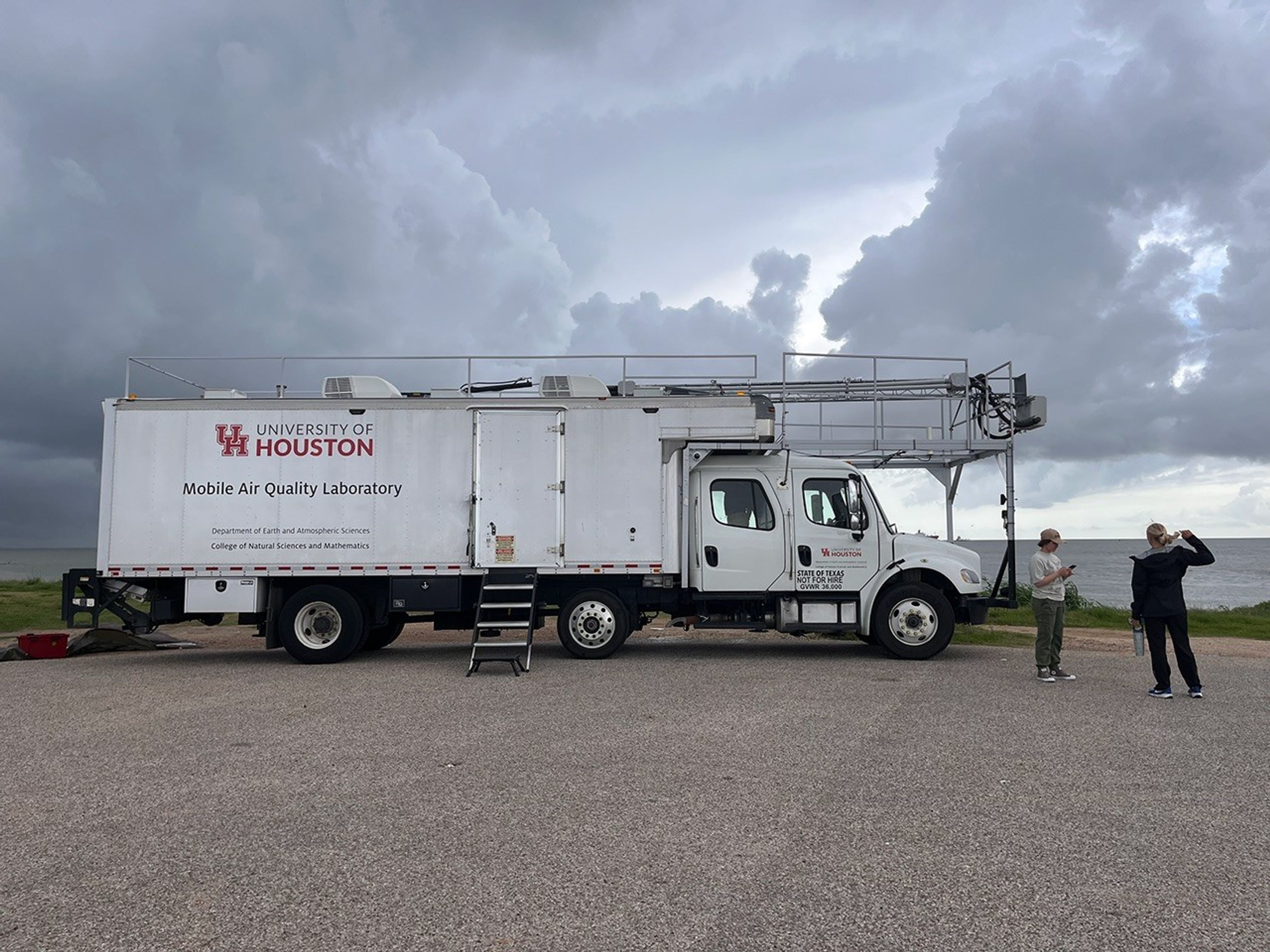
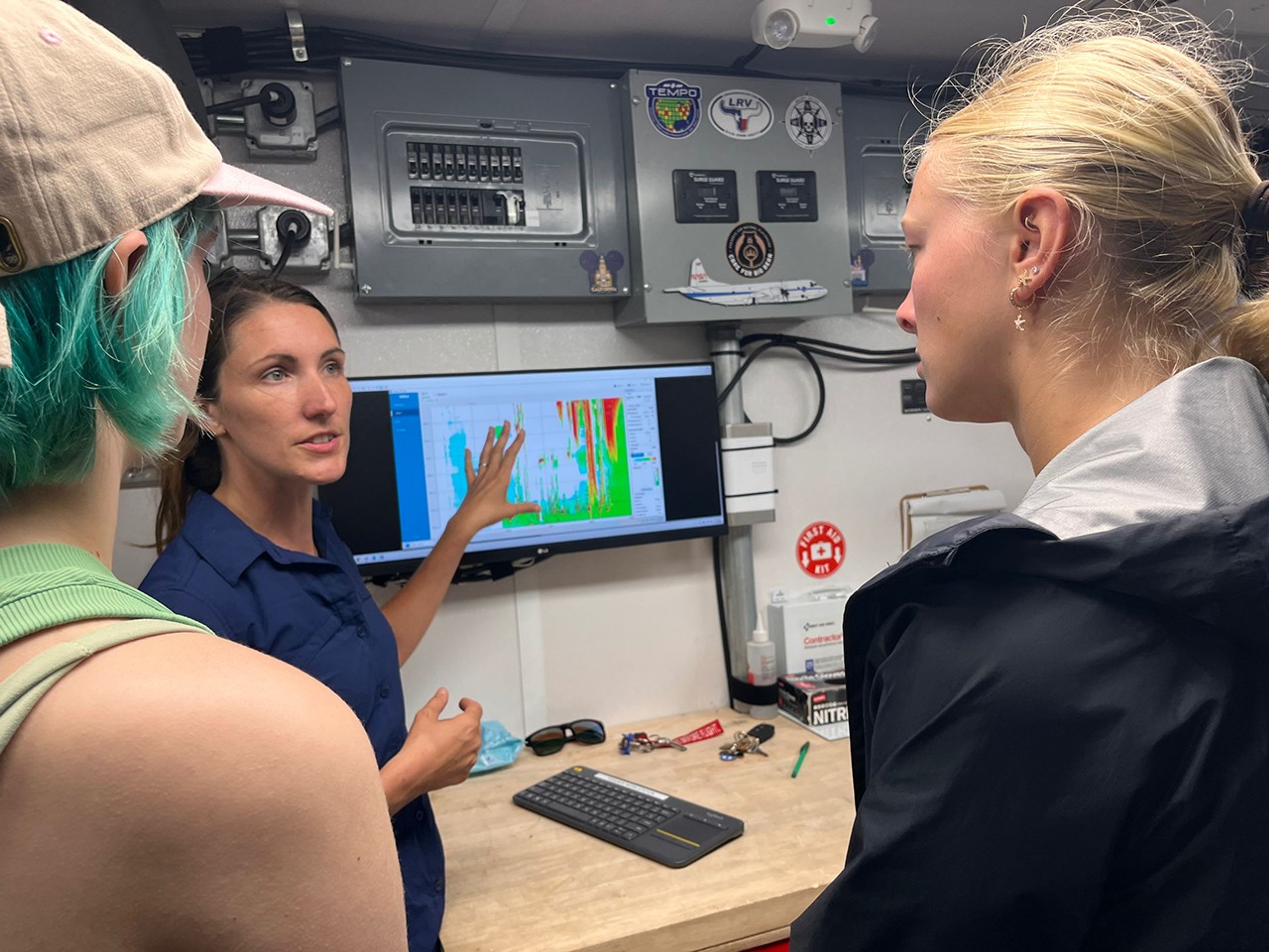
With the support of program mentors and faculty, and aboard the University of Houston’s Mobile Air Quality Laboratory (MAQL), the SARP interns participated in every step of the process.
The Mobile Air Quality Laboratory (MAQL) stands ready for some fieldwork.
NASA/Erica McNamee
Let’s set the scene: About 45 minutes away from this year’s SARP home base at the Lone Star Flight Museum in Houston, the MAQL drove down the Texas City Dike, a long strip of land jutting into the Texas Gulf Coast—an open space perfect for releasing the weather balloon. Among the 45 total students in the program, this group was assigned to meet the mobile lab at the balloon release location at 8 a.m. Central Time, just after a rainstorm rolled through.
Inside the lab, the students prepared ozonesondes for takeoff, completing the final steps that include measuring and pipetting cathode and anode solutions into the instrument cells attached to the sensor and testing each instrument’s response and baseline.
Outside the mobile laboratory, gusts of wind made it difficult to keep the balloon still while it was being filled with helium. Four students donned leather gloves to minimize oils from their fingers touching the balloon, which can make it pop faster after deployment. They wrangled the balloon while faculty advisor Travis Griggs, instructional assistant professor of atmospheric science from the University of Houston, filled it.
SARP students prepare the weather balloon for takeoff by filling it up with helium, while making sure it doesn’t pop or fly away.
NASA/Sofie Bates
Five students worked together to keep the balloon from flying away as they strung it to the ozonesonde, protected in a small foam container.
After confirming the launch location, time, and expected flight path with the Federal Aviation Administration (just a phone call away), it was time to set the weather instrument free.
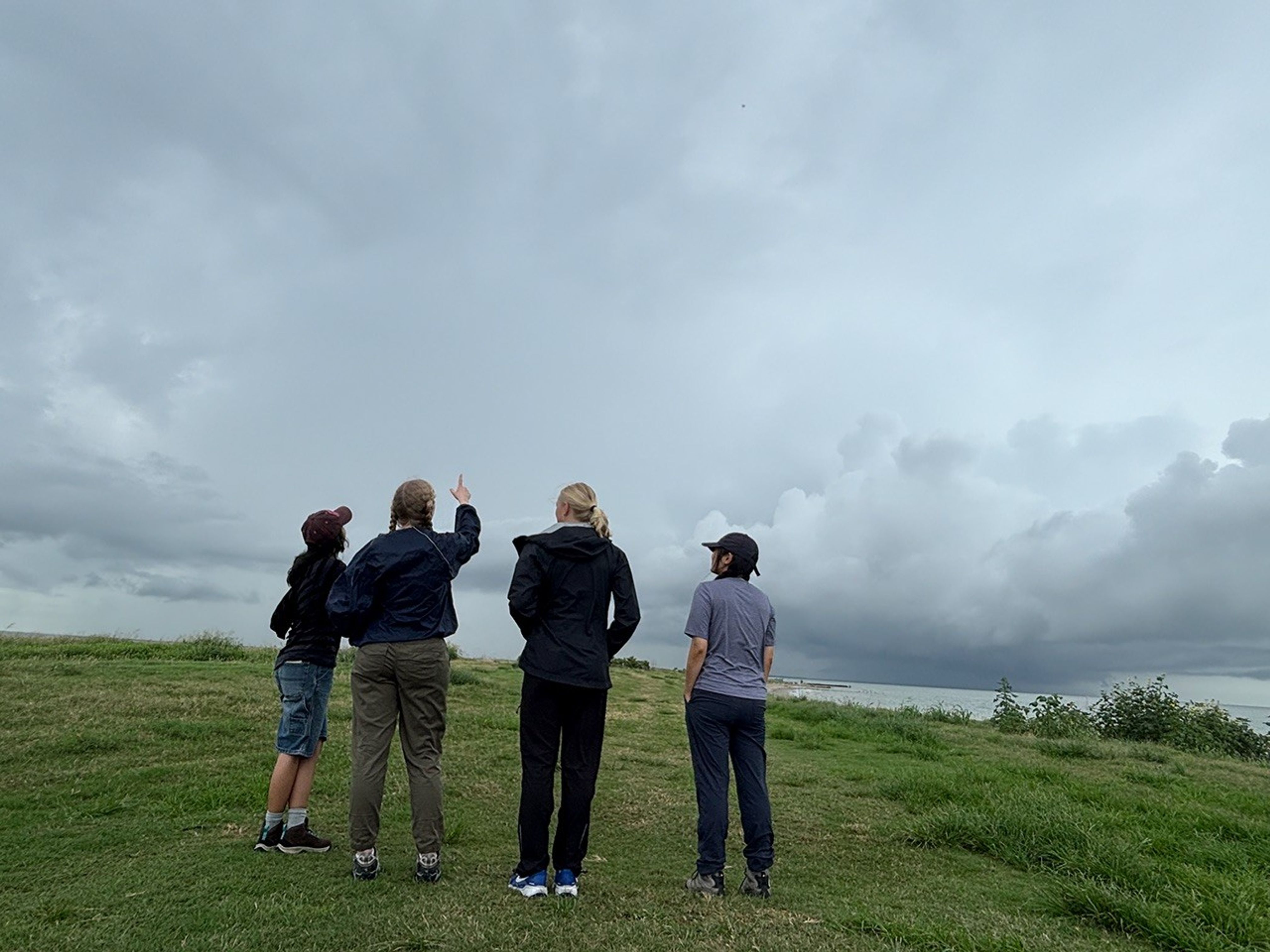
Even though it’s hard to see, there’s a tiny dot up in the sky—that’s the weather balloon! These students are admiring their work, watching their science experiment float up into the atmosphere to collect data.
NASA/Sofie Bates
“It was like a fight to stay on the ground, with the balloon whipping around in the wind,” said Zayna Haider, SARP intern and atmospheric and climate science student from the University of Washington. “It just flew away as soon as we let it go.”
But the work had only just begun. The students huddled back inside the MAQL, monitoring data as long as the balloon kept sending it—until it popped or landed, whichever came first. Throughout the day, they repeated this process with two other balloons.
Students inside the Mobile Air Quality Laboratory reviewed the data from the weather balloon they had just launched.
NASA/Erica McNamee
This day gave many SARP participants, just starting their science careers, their first glimpse at hands-on fieldwork that reached the edges of the atmosphere. Next, they would use this data and what they learned from the experience for their end-of-internship research presentation.
“This is beyond what I ever thought it could be,” Stevens said. “I’m super excited for the next seven weeks.”
Transforming NASA’s trusted Earth science into powerful business intelligence
Earth Science Private Sector Engagement
NASA Earth science data, tools, and expertise drive economic innovation by providing industry with trusted insights to accurately forecast risk, optimize operations, and advance next-generation business solutions. By connecting, informing, and partnering with businesses, NASA’s Private Sector Engagement Office unlocks new opportunities to reinforce the use of Earth observations in existing markets and broaden adoption across emerging industry sectors, empowering organizations to build powerful and resilient solutions for the future.
INNOVATE is NASA’s innovation funding program designed to accelerate the translation of Earth science into real-world applications. Selected teams receive access to NASA funding, data, and expertise to develop solutions that address commercial and societal challenges. This opportunity is open through August 31, 2026.
Investigators & Partners: NASA Goddard Space Flight Center; University of Wisconsin-Milwaukee; University of Colorado; University of Wisconsin-Madison; University of Connecticut; Swiss Re; Munich Re; Eversource
An AI-powered flood intelligence platform that combines NASA Earth observations with advanced modeling to deliver real-time flood forecasts and impact assessments, including Federal Emergency Management Agency and NOAA end users.
Designed with insurers and utilities to improve disaster response, risk management, and resilience.
Operational Risk Forecasting for AI Infrastructure
Investigators & Partners: NASA Goddard Space Flight Center; Universities Space Research Association; Meta; Uptime Institute; Open-IX
A first-of-its-kind system that uses NASA Earth observations to forecast operational risks to data centers, power systems, and water resources up to 14 days in advance.
Helps critical infrastructure operators anticipate disruptions before they occur.
Fire & Risk Modeling for Property Insurance
Investigators & Partners: National Science Foundation; National Center for Atmospheric Research; Mercury Insurance
A next-generation wildfire risk platform combining NASA Earth science, physics-based modeling, and AI to improve insurance underwriting and community resilience.
Developed with industry partners to better understand and manage growing wildfire risks.
Next-Generation Food Security Early Warning System
Investigators & Partners: Space Science Institute; Chapman University; World Food Program; Microinsurance Catastrophe Risk Organization
An advanced agricultural monitoring system that uses NASA Earth observations to detect food security risks months before traditional warning systems.
Supports insurers, humanitarian organizations, and agribusinesses with earlier, more actionable insights.
AI-Powered Wildfire Risk Intelligence for Utilities
Investigators & Partners: NASA Jet Propulsion Laboratory; OpalAI; Pacific Gas & Electric; Los Angeles Department of Water & Power
An AI-enabled wildfire intelligence platform that helps utilities identify asset-level wildfire risks and improve operational decision-making.
Designed to reduce outages, strengthen grid resilience, and protect communities.
Early Warning & Transparency for Forest Supply Chains
Investigators & Partners: NASA Goddard Space Flight Center; University of Maryland; Science Systems and Applications Inc.; Chainparency
A NASA-enabled monitoring and forecasting platform that helps forestry and wood-product industries track forest health, detect emerging risks, and improve supply chain transparency.
Supports more resilient and sustainable forest management at scale.
How NASA Helps Industry
How NASA supports agribusiness
Every day, farmers, food companies, and agricultural producers rely on timely, trusted information to manage their crops, land, water, and supply chains. NASA develops technology and missions to observe agricultural landscapes from space, informing optimal time and location for planting, monitoring of plant growth, best times for harvest, and market readiness assessments. U.S. and international partners use this information to support food security, stabilize markets, and strengthen productive farming.
From space, NASA tracks soil moisture, groundwater, crop condition, water use, heat stress, precipitation, and land change, while also supporting field-level tools and trusted partnerships with producers and agricultural organizations. By transforming satellite data into practical insights, NASA helps agribusiness to anticipate challenges, improve productivity, manage vital resources, and safeguard food systems.
The NISAR (NASA-ISRO Synthetic Aperture Radar) satellite captured an image of northeastern North Dakota on Aug. 23, 2025. The darker agricultural plots are plowed and unplanted fields, while the lighter colors represent the presence of pasture or crops. Circular patterns indicate the use of center-pivot irrigation.
NASA JPL
How NASA helps energy & utility companies
Energy providers, utilities, and infrastructure operators need trusted Earth information to plan for demand, protect assets, and keep essential services reliable. NASA Earth science supports decisions related to solar and meteorological resources, extreme heat, wildfire, air quality, flooding, drought, and land movement.
The Prediction Of Worldwide Energy Resources (POWER) project provides solar and meteorological data used by energy, building, and infrastructure communities. NASA Earth insights also help utility companies understand risks to grids, water systems, pipelines, and other critical assets and the Agency engages with partners such as the Center for Weather Innovation, Smart Energy and Resilience to advance Earth observation capabilities for the energy sector. Through data, training, stakeholder engagement, and partnerships, NASA equips energy and utility leaders with trusted information to strengthen resilience and support reliable operations.
This Black Marble data visualization shows how nighttime light changed year over year between 2014 and 2022 around the globe. Derived from satellite imagery taken daily over the past decade, golden areas featured brightening, purple areas featured dimming, and white areas experienced both kinds of changes.
NASA Scientific Visualization Studio
How NASA supports insurance & reinsurance
Insurance and reinsurance organizations depend on trusted information to understand hazards, price risk, support claims, and plan for changing risk exposure. NASA Earth science provides observations, models, and long-term records that help characterize events such as wildfire, flood, heat, drought, storms, land change, and infrastructure impacts.
NASA is engaging with the insurance and reinsurance community to better understand where Earth observations can support underwriting, catastrophe modeling, parametric products, claims response, and resilience planning. By participating in pre-competitive industry coalitions like the Center for Innovation in Risk, Catastrophes, and Decisions, as well as sector trainings and industry engagement, NASA helps insurers and reinsurers connect trusted Earth science with the decisions that shape risk, affordability, and recovery.
After unleashing dozens of destructive tornadoes, a slow-moving storm system dumped heavy rain across the U.S. Midwest and Southeast in early April 2025. A break in the clouds on April 7, 2025, revealed widespread flooding, shown in this image acquired by the Visible Infrared Imaging Radiometer Suite on the NOAA-21 satellite.
NASA Earth Observatory
How NASA helps the finance sector
Financial institutions, investors, and analysts need reliable information to understand physical risk, market exposure, and long-term change. NASA Earth science provides trusted data and models that help organizations to assess risk across assets, portfolios, and supply chains, including wildfire, heat, flood, land change, and infrastructure impacts.
NASA’s engagement with the finance sector focuses on helping users move from awareness to application, identifying relevant datasets, understanding uncertainty, and connecting Earth observations to real business decisions. Through training, collaborative sessions, and sector partnerships, NASA is working to make Earth science more accessible to financial decision-makers seeking trusted, science-based insights.
This screen capture from FIRMS shows Landsat active fire imagery of the Double Creek Fire in Oregon on September 10, 2022. The Landsat Active Fire and Thermal Anomalies product is generated from the Landsat Operational Land Imager (OLI).
NASA LANCE
How NASA helps mining and exploration
Mining and exploration companies rely on trusted geoscience information to understand landscapes, manage risk, and make decisions across the mineral resource life cycle. NASA Earth science observations can support characterization of terrain, land cover, water resources, surface change, environmental conditions, operational risks, and long-term landscape dynamics.
NASA is engaging with the mining and exploration community to better connect Earth observations with industry needs, from early exploration and resource assessment to operations, closure, and reclamation. Through participation in pre-competitive industry efforts such as the Center to Advance the Science of Exploration to Reclamation in Mining, as well as broader technical exchange and stakeholder engagement, NASA helps bring trusted data, models, and Earth system science into decisions that support responsible resource development.
Various minerals are revealed in vibrant detail in this sample mineral map of Cuprite, Nevada, following processing of imaging spectrometer data.
USGS
FEbruary 2026
Industry Summit Report
The NASA Earth Science Industry Summit, hosted by the U.S. Chamber of Commerce on February 2, 2026, served as a strategic forum to explore how NASA’s Earth Science enterprise contributes to the engines of the American economy and how public and private sectors can work together to unlock greater opportunities in Earth observation.
Explore the summary report for key reflections and takeaways, representing the perspectives of more than 180 participants across finance, insurance, agriculture, energy, utilities, and more.
Earthdata is your gateway to find, access, visualize, and download NASA Earth science data. Browse the data catalog, search by topic, discover learning resources including tutorials and trainings, and more.
NASA's Applied Remote Sensing Training Program (ARSET) teaches users how to use remote sensing data for a range of applications. ARSET trainings are available for all levels of experience at no cost, both in person and online.
The Fire Information for Resource Management System (FIRMS) tracks active fires and hotspots worldwide to support response, risk monitoring, and operational awareness.
Flood Water Monitoring
NASA’s Land, Atmosphere Near real-time Capability for Earth observation (LANCE) provides near real-time flood products, showing flooding and surface water changes to support exposure, claims, and resilience planning.
Economic & Human Activity
Night-time lights, visible with NASA’s Black Marble products, are used to monitor economic indicators, human activity, outages, infrastructure disruptions, and disaster recovery.
Heat & Temperature Insights
The ECOsystem Spaceborne Thermal Radiometer Experiment on Space Station (ECOSTRESS) instrument detects surface heat, crop water stress, urban heat, and thermal conditions affecting assets and operations.
Land Surface Change & Risk
The OPERA Surface Displacement (DISP) product suite identifies land surface movement from processes such as sinkholes, earthquakes, and landslides, supporting risk assessment for infrastructure and critical assets.
Long-Term Risk Projection
NASA Earth eXchange Global Daily Downscaled Projections (NEX-GDDP) provides historical baselines and future climate scenarios for asset, portfolio, and resilience planning.
Partnerships & Collaboration
NASA offers 60 years of experience in advanced engineering and testing capabilities, cutting edge research and technology development, as well as unique assets such as land, facilities and laboratories for use by commercial industries, academic institutions, U.S. government agencies and international entities.
Partnerships Front Door
Discover how NASA works with industry, academic, and non-profit partners to advance mutual goals through through strategic, non-procurement partnerships.
Eligible organizations that incorporate NASA data into their products, services, or research can gain significant value by displaying the NASA Data Insignia.
Katalyst Space’s LINK robotic servicing satellite awaits encapsulation inside a Northrop Grumman Pegasus XL on June 8, 2026, at NASA’s Wallops Flight Facility in Virginia. The rocket will carry LINK to space for an attempted orbital boost of NASA’s Neil Gehrels Swift Observatory.
NASA/Ron Beard
Engineers completed installation of Katalyst Space’s LINK robotic servicing spacecraft into a Northrop Grumman Pegasus XL rocket on Tuesday, June 9, at NASA’s Wallops Flight Facility in Virginia. Launch is anticipated later this month.
Our planet’s atmosphere creates drag for spacecraft in low Earth orbit, gradually reducing their altitudes if they don’t have propulsion systems to counteract the effect.
Recent solar activity magnified this effect on Swift, and its orbit decayed faster than anticipated.
Katalyst’s Hunter Robertson prepares LINK ahead of it being attached to the Pegasus XL inside the Horizontal Integration Facility at NASA Wallops on June 6, 2026.
NASA/Ron Beard
Based on the orbital and programmatic needs of the mission, Katalyst selected the air-launched Pegasus XL as the best means of reaching the observatory in time to perform the boost maneuver.
Northrop Grumman will launch the rocket using Stargazer, its modified L-1011 aircraft.
Next, Northrop Grumman engineers will attach Pegasus XL to Stargazer, which will carry it from NASA Wallops to Kwajalein Atoll, part of the Republic of the Marshall Islands in the South Pacific Ocean, for launch.

 Login