❌

Reading view

Total Solar Eclipse on August 12, 2026

August 12, 2026

Total Solar Eclipse

On Aug. 12, 2026, a total solar eclipse will sweep across Greenland, Iceland, northern Russia, the Atlantic Ocean, Spain, and a small corner of Portugal.
 
Many other places in the Northern Hemisphere will experience a partial solar eclipse that day, including parts of the northern U.S. (from Alaska to North Carolina), most of Canada, much of Europe, and northwestern Africa.
 
For many along the western part of the eclipse path (in mainland Europe and Africa), the Sun will set while it’s still partially eclipsed, creating an opportunity to see a sunset eclipse.

Eclipse map

A globe, centered on the North Atlantic, shows part of the Western Hemisphere including parts of North and South America, Europe, and Africa. A curved, red band runs from northern Russia, close to the North Pole, over parts of Greenland and Iceland, across the North Atlantic, and across parts of Spain. Yellow ovals appear periodically within the red band. A grid of green lines, which run roughly north to south, and yellow lines, which run roughly west to east, covers much of the rest of the hemisphere. The green lines have times on them and the yellow lines have percentages. The left, top, and right edges of the grid are bordered by a large, orange, figure-eight loop with a blue line running through the center of it.
A map shows where a solar eclipse will be visible on Aug. 12, 2026. The red band that crosses Greenland, Iceland, and Spain shows where a total solar eclipse can be seen. Yellow curves across the map show where a partial eclipse will be visible, and percentages indicate the maximum area of the Sun covered by the Moon during the eclipse along those lines. Learn more about the map.
NASA’s Scientific Visualization Studio

Total solar eclipse

Against a black background, the total solar eclipse. It is a black circle surrounded by white, wispy streams of light that flow away from the black circle in every direction.
A total solar eclipse was seen in Dallas, Texas, on Monday, April 8, 2024.
NASA/Keegan Barber

When the Moon slips in front of the Sun, those in the center of the Moon’s shadow will experience a total solar eclipse.

For a small, remote region in northern Russia, totality — when the Moon completely covers the Sun — will occur mid-day. For Greenland and Iceland, the Sun will go dark in the late afternoon or early evening. In Spain and the very northwestern tip of Portugal, the Sun won’t be fully eclipsed until the late evening, shortly before sunset.

For most in the path of totality, the Sun will be fully eclipsed for less than two minutes. For anyone near the very center of the eclipse path in Greenland, Russia, or the North Atlantic, totality will last a little longer (but still less than two and a half minutes).

Only during those brief moments of totality, when the Moon completely blocks the Sun’s bright face, can viewers look directly at the eclipse without eye protection.

Before and after totality, everyone observing the Sun must use eye protection to view the partial phases of the eclipse, when the Moon is covering only part of the Sun’s disk. Observers can use solar viewing glasses (often called “eclipse glasses”), handheld solar viewers, or other safe solar filters that block out most of the Sun’s light and prevent eye damage. Eclipse watchers can also use an indirect viewing method to enjoy the partial phases of the eclipse, such as making as a pinhole projector to cast images of the Sun.

Learn more about how to view a total solar eclipse safely.

Partial solar eclipse

A reddish sky is shown with the bright circle of the Sun, a dark bite taken out of it. The dark circle covering about a third of the Sun's left side is the Moon, during a solar eclipse. In the foreground is the silhouette of the U.S. Capitol.
A partial solar eclipse emerges from behind the United States Capitol on June 10, 2021, as seen from Arlington, Virginia.
NASA/Bill Ingalls

For eclipse watchers inside the Moon’s shadow but outside the path of totality, the Moon will never completely block the Sun and the eclipse will be partial only. During a partial solar eclipse, it is never safe to look directly at the Sun without proper eye protection.

The Aug. 12 partial solar eclipse will begin as the day begins in northern Russia. In Alaska and northern Canada, the eclipse will start and end in the morning, while Canada’s eastern provinces will experience the eclipse in the afternoon. In the northern contiguous U.S., the partial eclipse will begin around midday, lingering into the midafternoon for those farther east. The eclipse will reach the U.K., Ireland, mainland Europe, and Africa in the evening.

Those in the U.S. and southern Canada will see only a small “bite” taken out of the solar disk as the Moon appears to just clip the Sun. Those closer to the path of totality — across most of Europe and in northwestern Africa — will see most of the Sun get covered up.

When watching a partial solar eclipse directly with your eyes, always look through safe solar viewing glasses (“eclipse glasses”) or a safe handheld solar viewer. Eclipse glasses are NOT regular sunglasses; regular sunglasses, no matter how dark, are not safe for viewing the Sun. Safe solar viewers are thousands of times darker and ought to comply with the ISO 12312-2 international standard.

Do NOT look at the Sun through a camera lens, telescope, binoculars, or any other optical device while wearing eclipse glasses or using a handheld solar viewer — the concentrated solar rays will burn through the filter and cause serious eye injury. A special-purpose solar filter must be attached to the front of any telescope, binoculars, camera lens, or other optics to observe the Sun safely.

If you don’t have eclipse glasses or a handheld solar viewer, you can use an indirect viewing method, which does not involve looking directly at the Sun. One way is to use a pinhole projector, which has a small opening (for example, a hole punched in an index card) and projects an image of the Sun onto a nearby surface. With the Sun at your back, you can then safely view the projected image. Do NOT look at the Sun through the pinhole! Leaves on trees act as natural pinholes, projecting the shape of the eclipse onto the surface beneath them.

Learn more about how to view a partial solar eclipse safely.

Where to watch

Below are some details about the eclipse for select cities. All times are local.  

An asterisk (*) under “Partial Ends” indicates that the eclipse will end after sunset and the time given is for sunset.

Total eclipse

CityPartial BeginsTotality BeginsTotality EndsPartial Ends
León (Spain)7:32 p.m.8:28 p.m.8:30 p.m.9:22 p.m.
Reykjavík (Iceland)4:47 p.m.5:48 p.m.5:49 p.m.6:47 p.m.
Valencia (Spain)7:38 p.m.8:32 p.m.8:33 p.m.9:01 p.m. *
Zaragoza (Spain)7:34 p.m.8:29 p.m.8:30 p.m.9:07 p.m. *

Partial eclipse

CityPartial BeginsMaximumCoveragePartial Ends
Anchorage, Alaska (USA)7:36 a.m.8:21 a.m.28%9:09 a.m.
Bangor, Maine (USA)12:54 p.m.1:53 p.m.24%2:49 p.m.
Boston, Mass. (USA)1:01 p.m.1:55 p.m.16%2:46 p.m.
Detroit, Michigan (USA)1:03 p.m.1:36 p.m.3%2:08 p.m.
Fairbanks, Alaska (USA)7:37 a.m.8:27 a.m.37%9:18 a.m.
Juneau, Alaska (USA)7:41 a.m.8:24 a.m.17%9:08 a.m.
New York, New York (USA)1:07 p.m.1:54 p.m.9%2:38 p.m.
Philadelphia, Penn. (USA)1:11 p.m.1:53 p.m.7%2:35 p.m.
Portland, Maine (USA)12:57 p.m.1:53 p.m.19%2:27 p.m.
Washington, D.C. (USA)1:17 p.m.1:53 p.m.4%2:27 p.m.
Algiers (Algeria)6:42 p.m.7:33 p.m.96%7:42 p.m. *
Barcelona (Spain)7:35 p.m.8:29 p.m.99%8:54 p.m. *
Berlin (Germany)                             7:15 p.m.8:08 p.m.85%8:38 p.m. *
Casablanca (Morocco)6:48 p.m.7:43 p.m.87%8:20 p.m. *
Dakar (Senegal)6:25 p.m.7:12 p.m.37%7:34 p.m. *
Dublin (Ireland)6:12 p.m.7:10 p.m.94%8:05 p.m.
Edmonton (Canada)10:02 a.m.10:38 a.m.6%11:15 a.m.
Halifax (Canada)1:58 p.m.3:00 p.m.31%3:58 p.m.
Kraków (Poland)7:18 p.m.7:56 p.m.64%8:04 p.m. *
Lisbon (Portugal)6:39 p.m.7:36 p.m.95%8:29 p.m.
London (U.K.)6:17 p.m.7:13 p.m.91%8:06 p.m.
Madrid (Spain)7:36 p.m.8:32 p.m.99%9:16 p.m. *
Milan (Italy)7:27 p.m.8:20 p.m.92%8:35 p.m. *
Montreal (Canada)12:50 p.m.1:45 p.m.18%2:38 p.m.
Nuuk (Greenland)3:30 p.m.4:35 p.m.79%5:39 p.m.
Oslo (Norway)7:02 p.m.7:57 p.m.83%8:49 p.m.
Paris (France)7:22 p.m.8:17 p.m.92%9:09 p.m.
St. John’s (Canada)2:28 p.m.3:35 p.m.53%4:37 p.m.
Saint Petersburg (Russia)7:59 p.m.8:51 p.m.79%9:00 p.m. *
Stockholm (Sweden)7:03 p.m.7:56 p.m.81%8:46 p.m. *
Toronto (Canada)12:55 p.m.1:40 p.m.8%2:23 p.m.
Tunis (Tunisia)6:41 p.m.7:11 p.m.50%7:14 p.m. *
Vienna (Austria)7:22 p.m.8:10 p.m.85%8:13 p.m. *
Winnipeg (Canada)11:25 a.m.12:02 p.m.5%12:40 p.m.

The post Total Solar Eclipse on August 12, 2026 appeared first on NASA Science.

  •  

NASA Provides Update on Space Station Leak

The station pictured from the SpaceX Crew Dragon
The International Space Station is pictured from the SpaceX Crew Dragon Endeavour during a flyaround on Nov. 8, 2021.

The Zvezda service module’s transfer tunnel, known as the PrK, on the International Space Station has experienced cracks since 2019 that have resulted in small atmosphere leaks and prompted ongoing monitoring and repair efforts by Roscosmos. NASA and Roscosmos have worked together to identify the root cause while Roscosmos has been applying leak mitigation measures, including temporary and permanent sealants.

The week of June 1, during Progress 95 spacecraft cargo operations, Roscosmos noted an increase of the previous leak rate to two pounds per day and identified new suspected leak areas in the PrK. Following this observation, Roscosmos made the decision to begin work toward a more extensive inspection and structural repair effort Friday morning. This revised approach involved cutting a bracket to better access an area identified as a possible leak source for further inspection, using a method that could have resulted in elevated risk to the structure in the area. In response, NASA directed the four SpaceX Crew-12 members and NASA astronaut Chris Williams, who flew to station aboard the Soyuz MS-28 spacecraft, to take a heightened safety posture, known as a safe haven, inside the SpaceX Dragon spacecraft during the procedure.

Later Friday morning, Roscosmos paused and did not perform the structural repair work in favor of conducting additional measurements and data assessments, which included inspection of suspected areas of interest and review of areas where sealant was previously applied. NASA strongly supported that decision, and as a result, following that decision, Crew-12 and Williams ended their safe haven activities and returned to normal operations aboard the orbiting laboratory.

NASA will continue to work with our Russian counterparts, along with the rest of the international partners that support the space station, to assess and ensure a resolution to this matter.

Learn more about station activities by following the space station blog, @space_stationon X, as well as the ISS Facebook and ISS Instagram accounts.

Get the latest from NASA delivered every week. Subscribe here.

The post NASA Provides Update on Space Station Leak appeared first on NASA Science.

  •  

NASA’s INCUS Mission on Road to Launch, Study Storms From Space

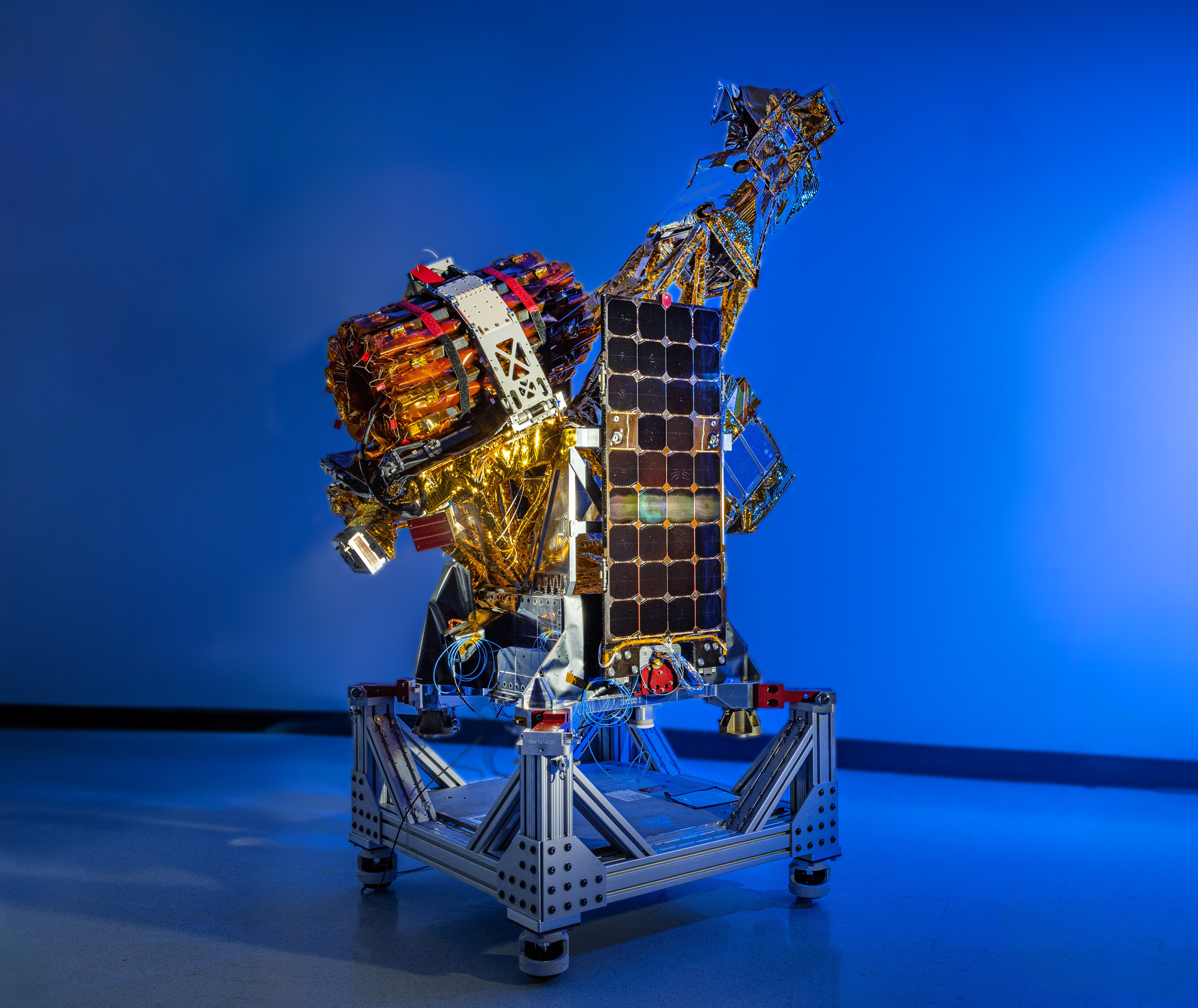
A complex spacecraft partially wrapped in gold-colored foil and featuring a large rectangular solar panel stands on a metallic support structure against a solid blue background.
Two of the three SmallSats for NASA’s INCUS mission, including the one shown here, have completed assembly and testing in preparation for shipment to NASA’s Wallops Flight Facility in Virginia for a 2027 launch. From low Earth orbit the satellites will observe the dynamics of tropical convective storms.
Blue Canyon Technologies

Teams working on NASA’s INCUS (Investigation of Convective Updrafts) mission, the first space-based survey of the dynamics of tropical convective storms, have completed assembly and tested two of the mission’s small satellites, or SmallSats. Testing continues on the third SmallSat and is scheduled for completion no earlier than September in advance of a 2027 launch.

The three satellites will fly in tight coordination in low Earth orbit, with the first and second satellites separated by 30 seconds and the second and third satellite by 90 seconds.

Characterized by the sudden and intense lifting of large amounts of air and water, tropical convective storms provide more than half of the world’s precipitation, a crucial source of life-supporting fresh water. But they also produce severe weather, which can increase risks to life and property. The INCUS mission will help improve understanding of where, when, and why convective storms form.

Led by principal investigator Sue van den Heever of Colorado State University in Fort Collins, INCUS will use spaceborne radar instruments developed at NASA’s Jet Propulsion Laboratory in Southern California to observe the vertical motion of air and water, known as convective mass flux, as storms develop and evolve. The mission will also explore how environmental factors such as air temperature, humidity, pressure, wind speed, and wind direction correlate with that movement.

These insights will improve storm forecasting, potentially mitigating loss of life and property damage in affected communities, by helping decision-makers plan for and respond to severe weather events and manage freshwater supplies. 

Teams at NASA JPL built each INCUS satellite’s radar, which were combined with a deployable mesh radar reflector made by Tendeg in Louisville, Colorado. The middle satellite also carries a microwave radiometer, also made at NASA JPL, that provides spatial context to the vertical precipitation profiles provided by the radars.

The three assemblies shipped in late 2025 and early 2026 to Blue Canyon Technologies in Lafayette, Colorado, where they were integrated with Blue Canyon’s spacecraft buses. The first two satellites, also called observatories, have successfully undergone vibration and thermal vacuum testing to ensure they will be able to withstand the jostling of launch and the extreme temperatures of space.

These two observatories also shipped to Tendeg, where teams successfully performed test deployments of the reflectors. Then they returned to Blue Canyon for additional testing. They’ll remain in storage before heading out next year to the launch site at NASA’s Wallops Flight Facility in Virginia.

Funded through the Earth Venture Mission-3 acquisition under NASA’s Earth System Science Pathfinder Program, INCUS is one of several missions fulfilling the clouds, convection, and precipitation requirements of NASA’s Earth System Observatory, a series of interconnected missions set to study our home planet’s dynamic natural systems and how they interact. The mission is also part of FALCON (Fleet for the Atmosphere Linking Commercial Observations with NASA), a fleet of atmosphere-observing satellites that will combine hardware contributions from NASA centers, universities, and commercial partners.

The post NASA’s INCUS Mission on Road to Launch, Study Storms From Space appeared first on NASA Science.

  •  

NASA’s X-59 Aircraft Flies Supersonic for First Time

4 min read

NASA’s X-59 Aircraft Flies Supersonic for First Time

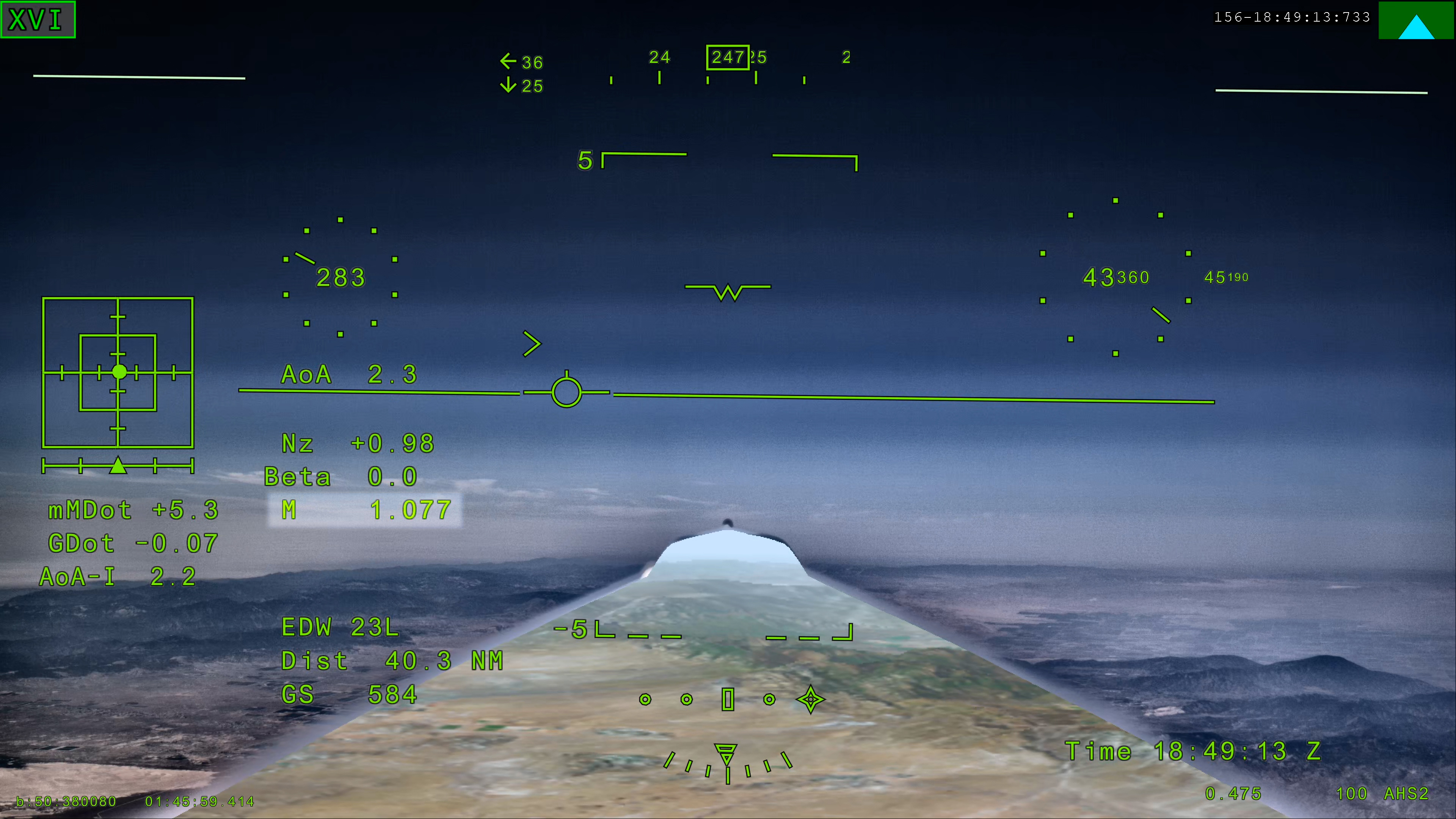
NASA’s X 59 eXternal Vision System digital display shows green flight data overlaid on the forward scenery as the aircraft flies supersonic. Numerical indicators, horizon references, and a Mach number readout are visible on the screen.
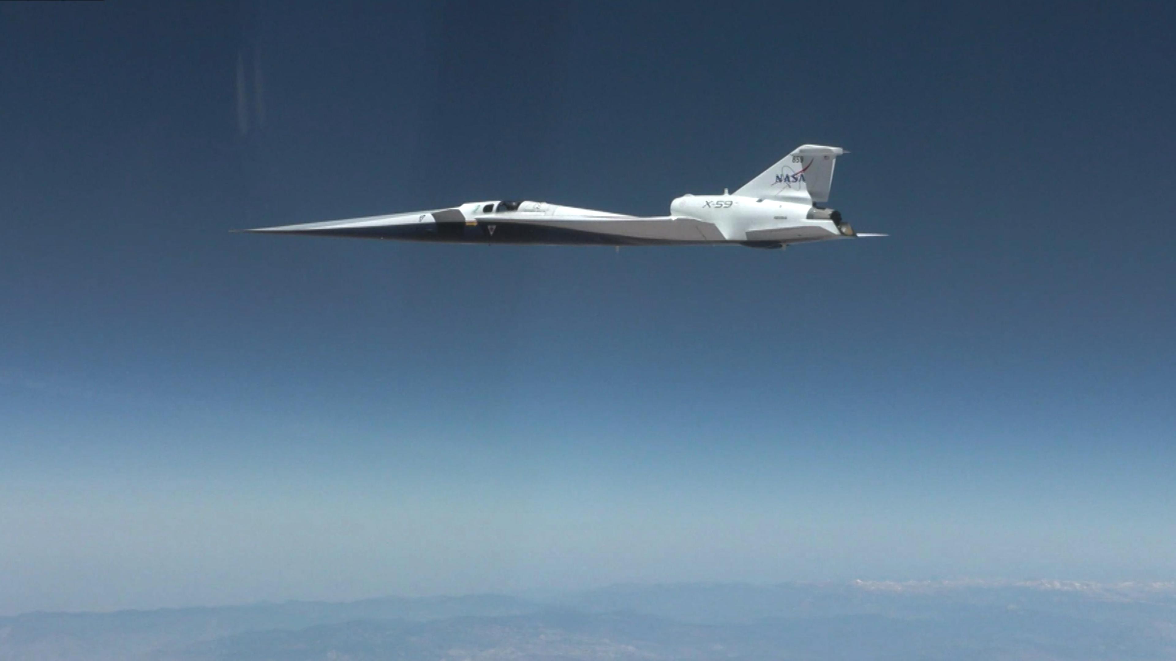
NASA’s X 59 eXternal Vision System shows Mach 1.077 on Friday, June 5, 2026, marking the aircraft’s first time reaching supersonic speed in support of NASA’s Quesst mission. The moment represents a milestone for the aircraft as it transitions to include test flights faster than the speed of sound.
NASA

NASA’s experimental X-59 aircraft marked a major milestone Friday, June 5, when it flew faster than the speed of sound for the first time, setting the stage for demonstrating its quiet supersonic capabilities later this year. 

NASA test pilot Jim “Clue” Less took off and landed at Edwards Air Force Base in California, reaching a top speed of approximately Mach 1.1 (713 mph) and altitude of 43,400 feet. The X-59’s flight began at 11:08 a.m. PDT and lasted 81 minutes, with the team focusing on flying qualities at both subsonic and then supersonic speeds.  

In the coming days, we expect to take the next step and push to Mach 1.4

jared isaacman

jared isaacman

NASA Administrator

”X-59 is getting ready for its quiet supersonic debut. Since the aircraft’s first flight on Oct. 28, 2025, the team has made tremendous progress, flying 16 times in the last 90 days and getting into a steady test rhythm. In the coming days, we expect to take the next step and push to Mach 1.4,” said NASA Administrator Jared Isaacman “I’m grateful to the NASA team and Lockheed Martin Skunk Works for their help getting us to this point, and I hope this is the first of many collaborations as we rebuild NASA’s X-plane portfolio.” 

The X-59 is designed to fly at supersonic speeds while creating only a quiet thump instead of a loud sonic boom. For this flight, a NASA F‑15 chase plane flew nearby to monitor the X‑59. The loud sonic booms from the F-15 obscured any sound made by the X-59.  

“The X-59’s first supersonic flight is a testament to America’s enduring leadership in science, engineering, and aerospace innovation,” said Michael Kratsios, Assistant to the President for Science and Technology and Director of the Office of Science and Technology Policy. “This achievement comes as the Trump Administration continues work to unleash supersonic flight and enable American ingenuity.” 

This first supersonic flight is a significant milestone, but an event even more critical to the mission is upcoming. In just days, the aircraft is expected to make its first “mission conditions” flight, reaching a cruising speed of Mach 1.4 (925 mph) and altitude of approximately 55,000 feet. The X-59 also will be accompanied by a chase plane for this flight.  

NASA’s X-59 quiet supersonic research aircraft flies above the clouds during its first supersonic flight. The aircraft is shown in side profile during level flight with desert and mountain terrain visible below.
NASA’s X-59 quiet supersonic research aircraft completed its first supersonic flight Friday, June 5, 2026, marking the first time the aircraft exceeded the speed of sound in support of NASA’s Quesst mission. The milestone represents a major step in flight testing as the aircraft expands into the supersonic portion of its flight envelope.
NASA / Lori Losey

This speed and altitude are the base conditions for the X-59 when it will eventually fly over several U.S. communities enabling NASA to gather data about how people may perceive its quiet thump. NASA will share this data with U.S. and international regulators to help establish new data-driven noise standards to enable a future viable market for supersonic commercial flight over land. 

For the last several months, the X-59 has been participating in an ongoing series of flights where the plane has been flying at a wide range of speeds and altitudes – a process known as envelope expansion. These tests are the first phase of the X-59’s flight testing. They are focused on performance and involve chase plane monitoring. When the aircraft completes this phase it will enter another, focused on its sound profile in order to verify its quiet thump capability.  

The X-59 is the centerpiece of NASA’s Quesst mission, which aims to demonstrate quiet supersonic flight and help enable commercial supersonic flight over land worldwide. These advancements will help travelers reach their preferred destinations faster, spending less time in the air. 

Through Quesst’s development of the X-59, NASA also will deliver design tools and technology for quiet supersonic airliners that will achieve the high speeds desired by commercial operators without disturbing people on the ground. NASA will validate design tools through ground and flight testing, providing U.S. aircraft manufacturers the ability to explore new quiet supersonic concepts, and provide them with confidence that their resulting designs will meet quiet flight requirements.  

quesst-logo-horizontal-051826sm

Read more about NASA’s Quesst mission and the X-59.

Keep Exploring

Discover More Topics From NASA

The post NASA’s X-59 Aircraft Flies Supersonic for First Time appeared first on NASA Science.

  •  

NASA Announces Winners of 2026 University Innovation Competition 

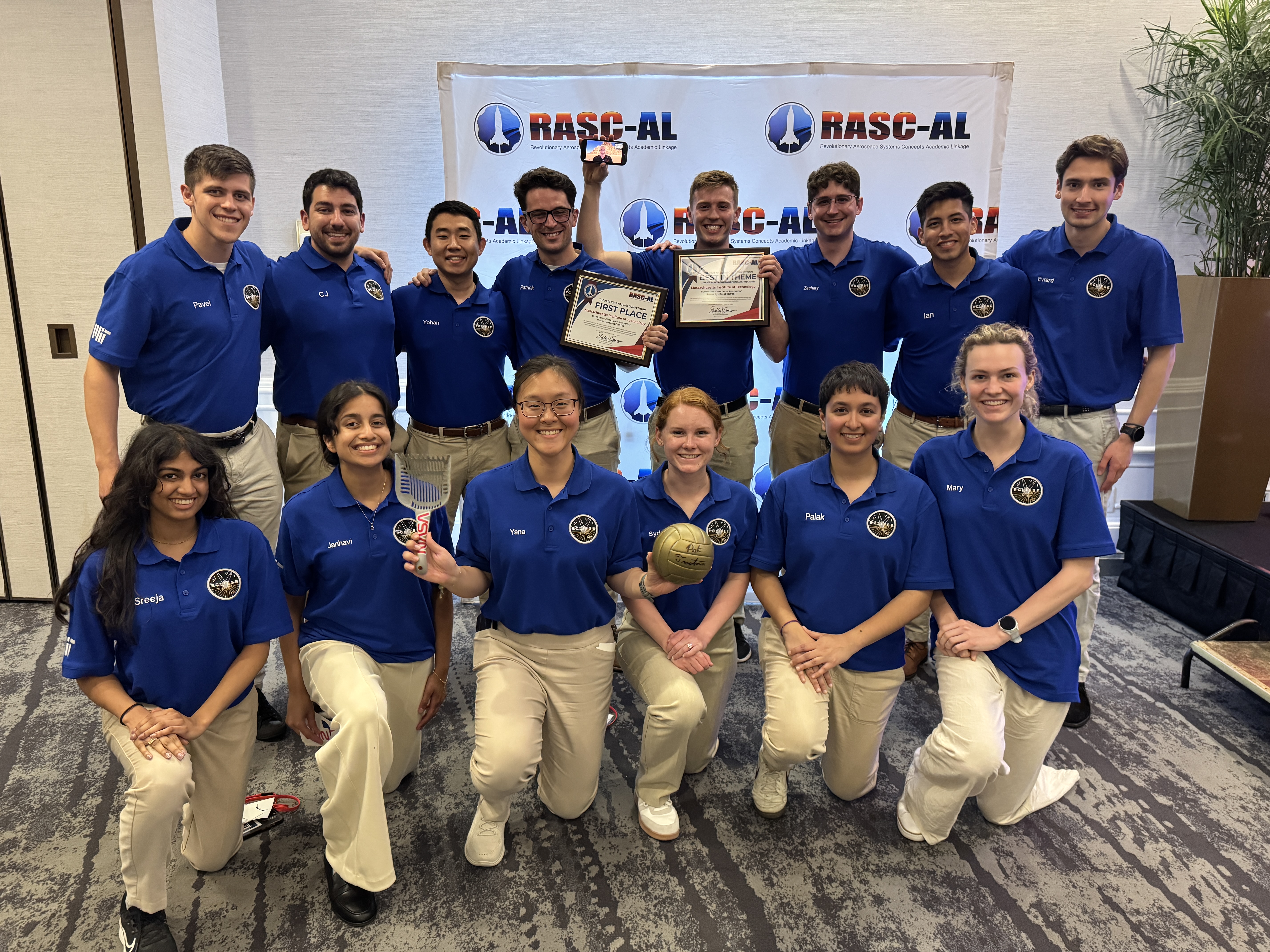
A group of 14 students wearing blue polo shirts smile at the camera while holding the first place certificate for winning the NASA RASC-AL challenge.
The Massachusetts Institute of Technology team that won the 2026 RASC-AL competition for their project, Exploration-Class Lunar Integrated Power SystEm.
Credit: National Institute of Aerospace

NASA announced the Massachusetts Institute of Technology project, Exploration-Class Lunar Integrated Power SystEm, as the first place winner for the 2026 Revolutionary Aerospace Systems Concepts – Academic Linkage (RASC-AL) competition, which challenges students to bridge gaps in aerospace technology by innovating new system concepts and prototypes. 

Another team from the same university won second place overall for their project, Mars Exploration Layered Infrastructure for Operations, Research, and Advancement, while Virginia Polytechnic Institute and State University took third place with the Mars Pylon Network.  

Empowering the next generation, the competition also supports the agency’s workforce development priorities by offering university teams hands-on experience in mission architecture development, systems engineering, and technical communication. 

“The winning teams demonstrated how academic innovation can support Artemis mission goals,” said Daniel Mazanek, program sponsor for RASC-AL and senior space systems engineer, NASA’s Langley Research Center in Hampton, Virginia. “Their work highlights the important role student research plays in shaping future space exploration, and the results showcase how disciplined analysis can elevate innovative ideas into viable exploration concepts.”  

Fourteen finalists attended the multi-day RASC-AL Forum in Cocoa Beach, Florida, and gave formal presentations outlining their mission architectures, technology solutions, and supporting analysis. These discussions provided students with real-time engineering feedback, exposing them to the rigor and scrutiny applied to human spaceflight concepts under development within the agency. 

Awards were presented to teams demonstrating the highest levels of technical rigor, innovation, and mission alignment. In addition to the top prizes, other awards included: 

  • Best in Communications, Position, Navigation, and Time Architectures for Mars Surface Operations Theme: Massachusetts Institute of Technology 
    Mars Exploration Layered Infrastructure for Operations, Research, and Advancement MELIORA)
  • Best in Lunar Sample Return Concept Theme: South Dakota State University 
    Sample Extraction of Lunar Elements for Network Entry (SELENE)
  • Best in Lunar Surface Power and Power Management and Distribution Architectures Theme: Massachusetts Institute of Technology 
    Exploration-Class Lunar Integrated Power SystEm (ECLIPSE) 
  • Best in Lunar Technology Demonstrations Leveraging Common Infrastructure Theme: Massachusetts Institute of Technology 
    CLPS-enabled Highly-autonomous End-to-End isruSystem Evaluations to Build Understanding and Resilient Growth by Experimenting with Regolith (CHEESEBURGER) 
  • Best Prototype: 

    Embry-Riddle Aeronautical University, Worldwide Campus 
    Advanced Utilization of Resources for Energy & Viability Off-Earth (Project AUREVO)
    University of Illinois, Urbana-Champaign with Leonardo de Vinci Engineering School 
    Mining and Advanced Transformation of Regolith for Infrastructure and eXpansion (MATRIX) 

“The RASC-AL program allows students to demonstrate their ability to transform innovative concepts into technically sound studies, with emphasis on technical rigor, clear communication, and systems-level thinking,” said Christopher Jones,  program sponsor for RASC-AL and chief technologist for the Systems Analysis and Concepts Directorate at NASA Langley. “These are the hallmarks of effective engineering that we’re looking for and reflect the standards required for real-world aerospace problem-solving,”  

The NASA RASC-AL competition represents a cross-agency collaboration. The competition is administered by the National Institute of Aerospace and managed by the NASA Tournament Lab, part of the agency’s Prizes, Challenges, and Crowdsourcing Program.  

For more information, visit:  

https://go.nasa.gov/3GS1OGm

The post NASA Announces Winners of 2026 University Innovation Competition  appeared first on NASA Science.

  •  

NASA’s Artemis II Moon Mission Research Continues on Earth

5 min read

NASA’s Artemis II Moon Mission Research Continues on Earth

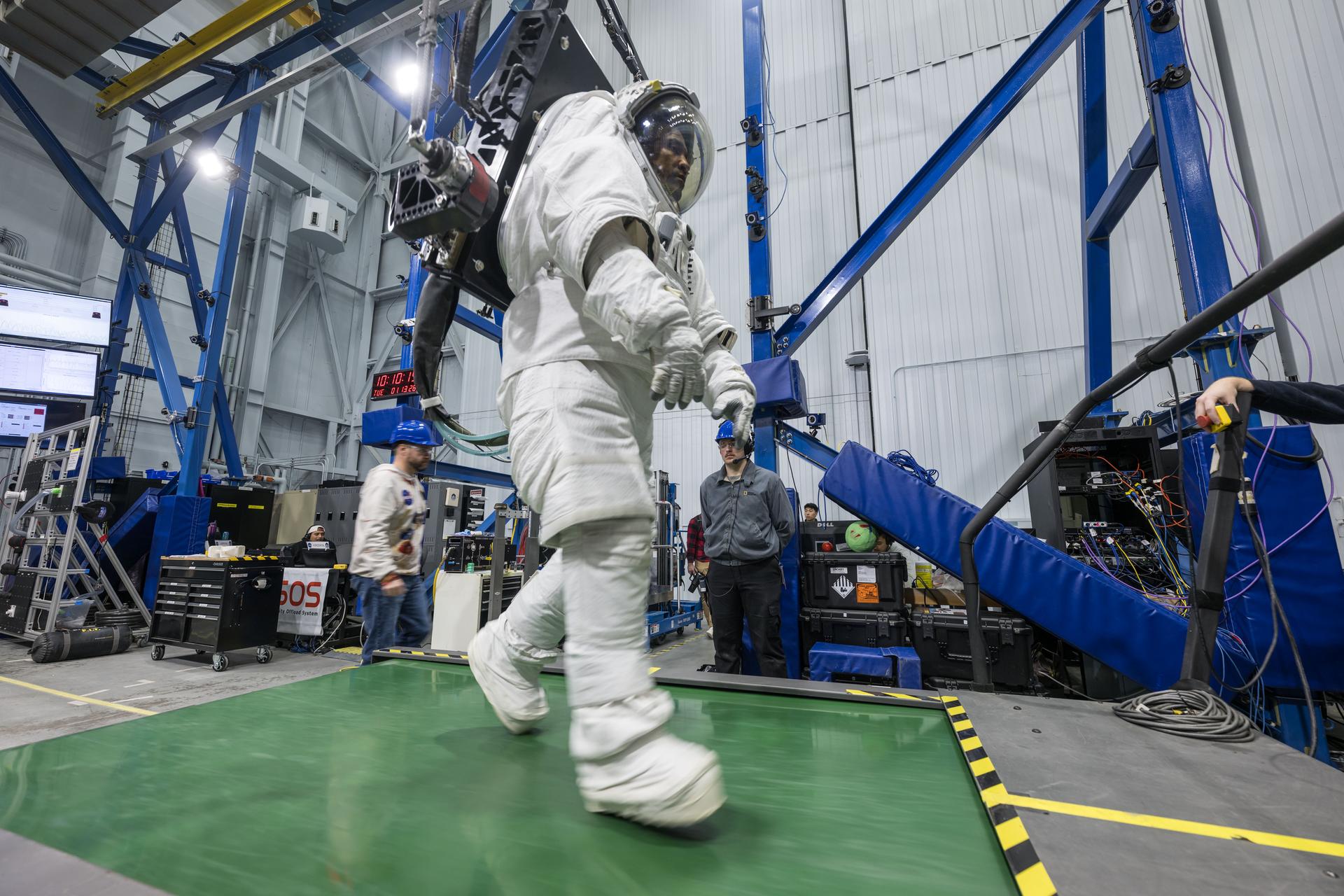
Dressed in a white space suit—with hands gloved, feet booted and head in a helmet with a clear visor—Artemis II astronaut Victor Glover walks on a wide green treadmill. His suit is harnessed to a black machine that is taking the weight off Glover such that, while in the suit, he experiences forces equivalent to lunar gravity. Two people wearing casual clothes and blue hard hats stand in the background, waiting to support Glover and the experiment, should the need arise.  Behind Glover are crisscrossing blue iron beams that stretch to a high ceiling in this industrial building at NASA’s Johnson Space Center.
Artemis II astronaut Victor Glover walks on a treadmill while in a space suit harnessed to NASA’s Active Response Gravity Offload System at NASA’s Johnson Space Center. Glover is simulating a walk on a planetary surface while in a suit that has been offloaded to lunar gravity. Artemis II astronauts completed this and other suited tasks before their mission launched and within a few days of landing, giving researchers a chance to assess how quickly upon landing crews’ bodies adapt to a different gravity. Results will help scientists better understand how soon after landing crews can complete mission-critical tasks on the surface of the Moon or Mars.
NASA/Robert Markowitz

Since NASA’s Artemis II crew members safely splashed down in the Pacific Ocean on April 10 after their record-setting mission around the Moon, science teams have been busy collecting more data and combing through observations collected on the test flight. Results from these science investigations will help support safe human exploration of deep space and provide a blueprint for how future missions will conduct science on the lunar surface as NASA builds a Moon Base and develops an enduring human presence there.

Postflight crew health, performance data

In the hours, days, and weeks after landing, the Artemis II crew members, NASA astronauts Reid Wiseman, Victor Glover, Christina Koch, and CSA (Canadian Space Agency) astronaut Jeremy Hansen, contributed critical data to help the agency understand how the human body reacts to spaceflight. Collecting this data as soon as possible after landing was important to understand how the body adapts from microgravity to Earth’s gravity. The data will inform NASA’s understanding of how quickly crews can complete mission-critical tasks after landing on a planetary surface like the Moon or Mars, where there won’t be landing support personnel to assist.  

Within a day of splashdown, researchers collected a suite of data for the Artemis II Spaceflight Standard Measures study, which is part of a larger effort across the astronaut corps to gather a baseline set of health measurements on blood pressure, heart rate, eye health, and motor control. Crew members also completed a mini obstacle course, which included lying down, standing up, unfurling a rope ladder, ladder climbing, and more, to assess how their bodies were adapting to Earth’s gravity.

Once the crew returned to NASA’s Johnson Space Center in Houston, researchers guided them through further medical check-ups and tests of motor control. Over the next several days, the crew completed obstacle courses wearing spacesuits offloaded to lunar gravity, which is roughly one-sixth the force of Earth’s gravity. Researchers are now analyzing this data to gain insight into how crews may perform as they adapt to the gravity of a planetary surface.

As part of the Immune Biomarkers study, researchers are comparing blood and saliva samples collected after the Artemis II splashdown with samples collected preflight and during the mission. Among other topics, the study investigates whether and how dormant viruses reawaken in astronauts’ bodies while in space.

Some crew members completed postflight cognition tests and a simulated manual spacecraft docking task to assess motor control for the ARCHeR (Artemis Research for Crew Health & Readiness) study. This, combined with data collected through a wrist-worn device while crew members were in space, is used to understand the effect of space hazards on well-being and performance.

Initial data collections for Artemis II health studies concluded 45 days after splashdown. However, medical teams will continually monitor astronaut health throughout the Artemis II crew members’ lifetimes.

Once this data is processed and anonymized, information will be available for scientists to study the effects of spaceflight via a request to NASA’s Life Sciences Data Archive. The results from this work could lead to new technologies and studies that help predict the adaptability of crews on future missions to the Moon and Mars.

Analyzing astronaut-derived organ chips flown around Moon

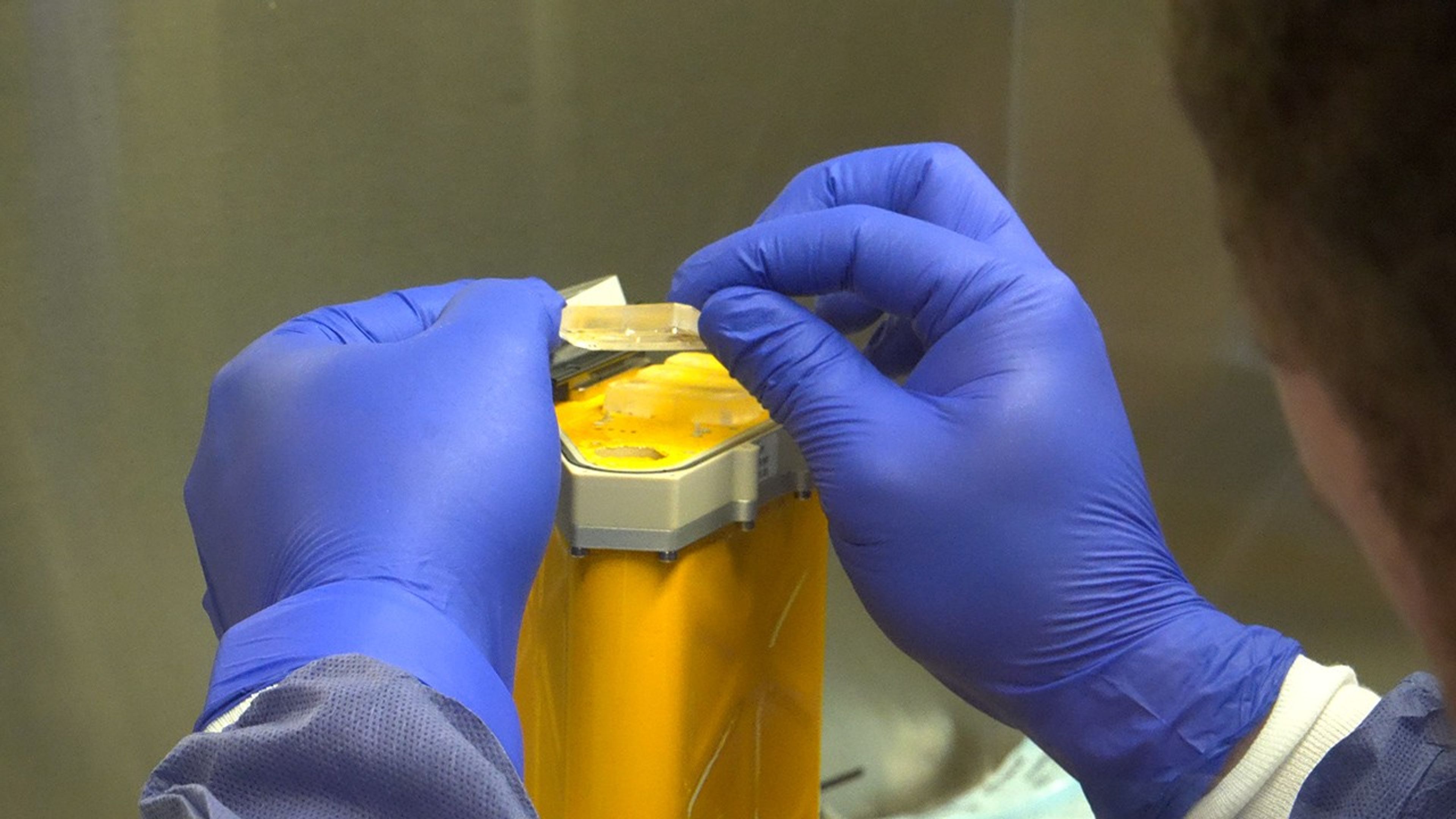
A person wearing blue gloves holds a small cylindrical organ chip.
A scientist handles AVATAR organ chips following their journey around the Moon aboard Orion. The chips contain cells from each astronaut and are being prepared for detailed analysis.
NASA

Organ chips from NASA’s AVATAR (A Virtual Astronaut Tissue Analog Response) investigation are being analyzed at chip developer Emulate’s laboratory in Boston. The organ chips included bone marrow cells from each Artemis II astronaut. They flew around the Moon with the astronauts, and now researchers are studying these organ chips to determine how deep space radiation and microgravity affect human health at the molecular level.

Scientists are comparing the chips flown aboard the spacecraft to ground controls and crew blood samples using advanced techniques, including single-cell RNA sequencing. The analysis will characterize how organ chips model individual responses to spaceflight, which is data that could allow NASA to send future astronauts’ AVATAR chips ahead on missions to develop personalized medical kits. The researchers plan to share early findings at scientific conferences while full analysis continues.

Lunar imagery, audio for data release

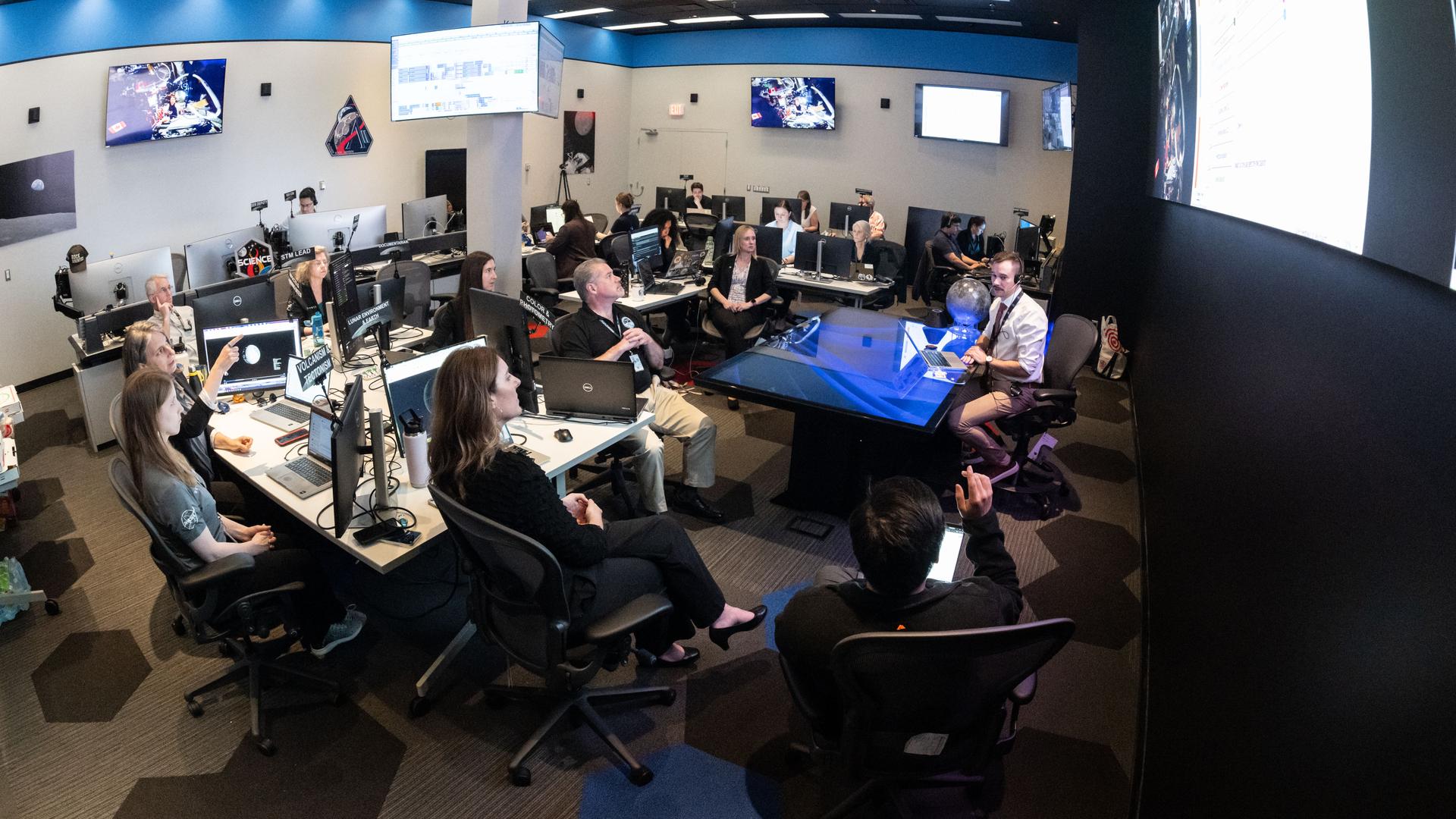
A large operations room filled with about two dozen staff members seated at computer workstations. Rows of desks with multiple monitors face a central area where a person sitting at a glass-topped desk appears to be speaking to the group. Large screens mounted on the walls display space-related imagery and data. Several people are looking towards a large screen hanging on a wall on the right of the image, while others work at their computers. The room is brightly lit, with blue accents along the walls, creating the atmosphere of a space operations or flight control center.
In this April 3, 2026, image, the Artemis II lunar science team is shown working in the Science Evaluation Room in the Mission Control Center at NASA’s Johnson Space Center in Houston. The team is putting together a plan of science observations for the Artemis II crew, which was headed toward the Moon aboard Orion. As they passed the Moon at closest approach on April 6, the crew applied the geology skills they learned in the classroom and in Moon-like environments on Earth as they photographed and described nuances of geologic features such as impact craters, ancient lava flows, and surface cracks and ridges. The crew noted differences in color, brightness, and texture — details that provide clues to surface composition and history.
NASA/Bill Stafford

On April 6, the Artemis II crew members studied features on and around the Moon for nearly seven hours during Orion’s closest approach to the lunar surface. Their work was guided by a minute-by-minute observation plan developed by the Artemis II lunar science team.

Scientists are reviewing the data collected from the mission, which includes images, video, and audio files, to release a report of their initial data interpretations later this year. The report will cover observations of impact flashes, variations in color on the lunar surface, and the shape and texture of faults and ridges. The team also will publish a report on how Artemis II lunar science observations were planned, organized, and executed for the benefit of future Artemis missions.

NASA will publish more than 100 science-related audio recordings with transcripts, as well as approximately 11,500 Earth and Moon image and video files from the mission science campaign, with accompanying data. While many of these images already are public, these records will be available through NASA’s Planetary Data System, a public archive of data from all of NASA’s planetary missions. To get the data ready, the team is converting files into standard formats that anyone can easily open and add information to make the data searchable in NASA’s archive for generations to come.

For more information on NASA’s Artemis II science efforts, visit:

https://www.nasa.gov/humans-in-space/artemis-ii-science/

Karen Fox / Molly Wasser

Headquarters, Washington

240-285-5155 / 240-419-1732

karen.c.fox@nasa.gov / molly.l.wasser@nasa.gov

The post NASA’s Artemis II Moon Mission Research Continues on Earth appeared first on NASA Science.

  •  

Robotic Spacecraft for Swift Boost Mission Arrives at NASA Wallops

Photograph of a large hangar
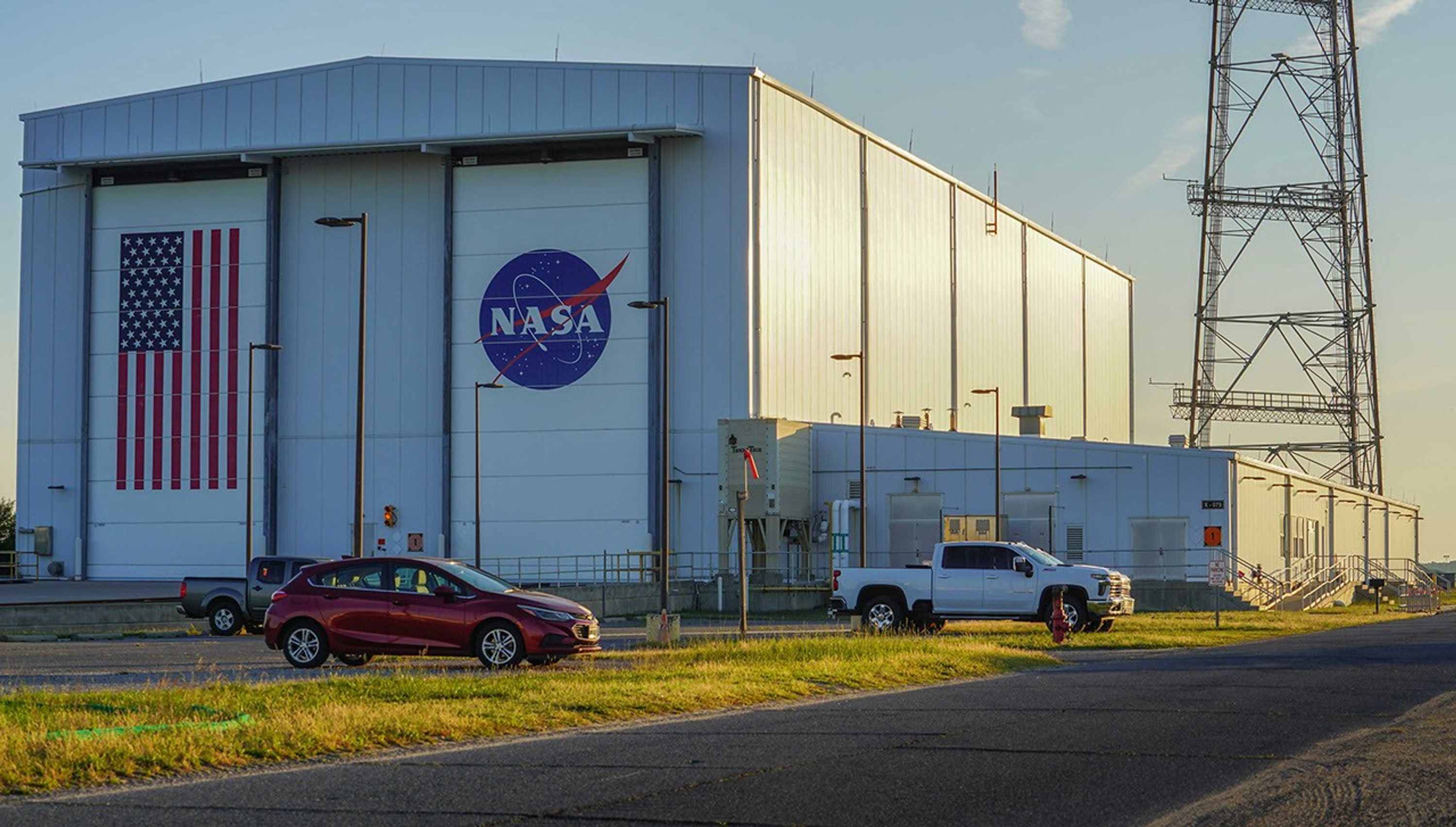
Northrop Grumman will load the LINK robotic servicing spacecraft from Katalyst Space into a Pegasus XL rocket at the Horizontal Integration Facility at NASA’s Wallops Flight Facility in Virginia, shown here. LINK arrived at Wallops on June 5, 2026, to begin integration.
NASA/Ron Beard

The LINK robotic servicing spacecraft, built by Katalyst Space and designed to capture and boost NASA’s Neil Gehrels Swift Observatory arrived at the agency’s Wallops Flight Facility in Virginia on Friday, June 5.

Inside NASA Wallops’ Horizontal Integration Facility, Northrop Grumman engineers will install the satellite into one of the company’s Pegasus XL rockets ahead of launch.

All spacecraft in low Earth orbit experience drag caused by our planet’s atmosphere. As a result, satellites without propulsion systems to counteract this effect gradually lose altitude and fall toward Earth.

Recent increased solar activity magnified the impact of atmospheric drag on Swift, causing it to sink faster than anticipated.

NASA contracted Katalyst to boost the 21-year-old observatory back to a higher altitude, pioneering a new servicing capability for the nation’s spacecraft fleet and allowing Swift to resume science observations.

After loading LINK into the Pegasus XL, Northrop Grumman will attach the rocket to the bottom of Stargazer, the company’s modified L-1011 aircraft.

Stargazer will deploy Pegasus XL from above Kwajalein Atoll, part of the Republic of the Marshall Islands in the South Pacific Ocean, later this month. The rocket will deliver the LINK spacecraft to an orbit where it can reach Swift.

As activities on the ground have raced to get LINK to Swift, the observatory team has been continuously making Swift’s orientation more aerodynamic to preserve altitude.

Learn more about the Swift mission at:

https://science.nasa.gov/mission/swift/

By Jeanette Kazmierczak
Goddard Space Flight Center, Greenbelt, Md.

The post Robotic Spacecraft for Swift Boost Mission Arrives at NASA Wallops appeared first on NASA Science.

  •  

Swift Boost Media Resources

Swift Boost Mission

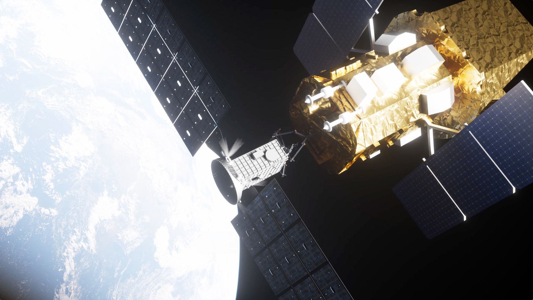
Illustration of the LINK and Swift satellites

Swift Boost Media Resources

After more than two decades, the orbit of NASA’s Neil Gehrels Swift Observatory has entered a phase of rapid decay. While NASA could allow the observatory to re-enter Earth’s atmosphere, as many missions do at the ends of their lifetimes, this situation has presented an opportunity to advance American spacecraft servicing technology while also extending the life of a productive science mission. To accomplish this, NASA awarded the U.S. company Katalyst Space a contract in September 2025 to attempt to raise Swift’s orbit.

People maneuver a spacecraft into a large chamber.
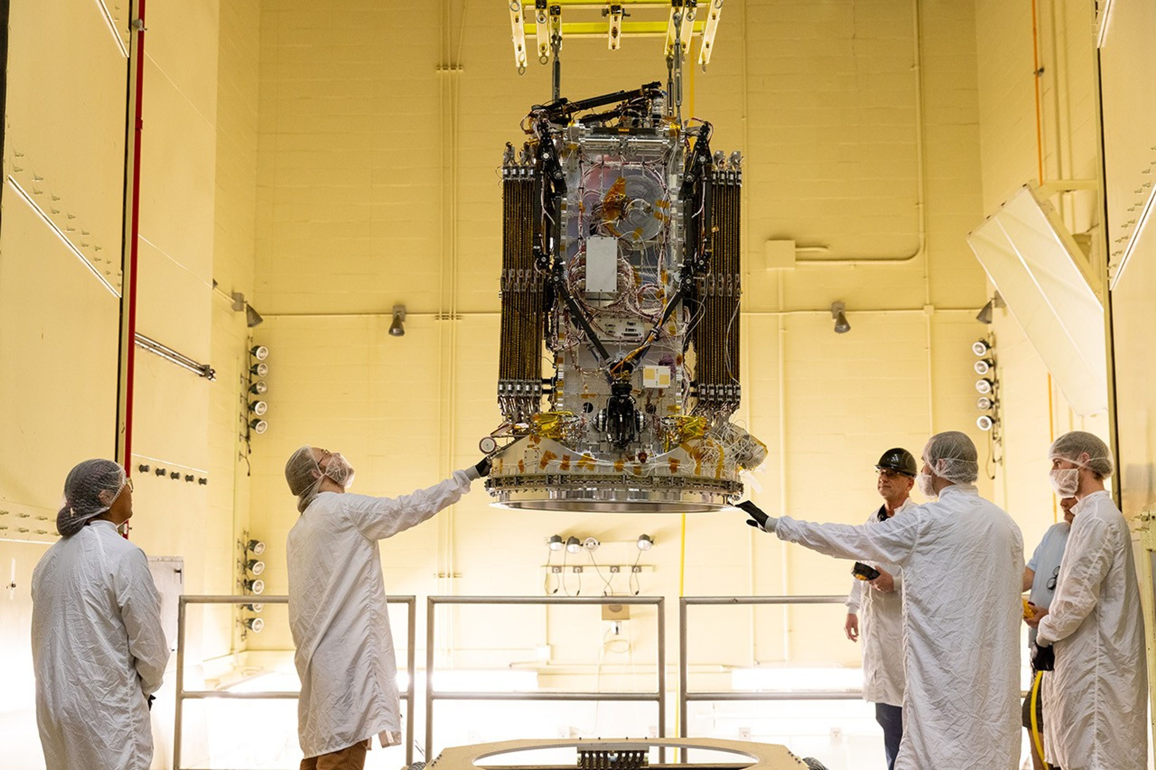
Engineers from Katalyst Space Technologies in Flagstaff, Ariz., stabilize their LINK robotic servicing spacecraft as it moves into a vibration chamber at NASA’s Goddard Space Flight Center in Greenbelt, Md., on April 15, 2026. The vibration chamber simulated the intense shaking LINK will experience during launch.
NASA/Scott Wiessinger

NASA studies how the Sun impacts the space environment, including objects in low Earth orbit, and recent increased solar activity has accelerated Swift’s decay. This has put NASA in a race against the clock before Swift re-enters Earth’s atmosphere in fall 2026. Katalyst’s robotic servicing spacecraft, LINK, will launch on its mission to boost Swift in June 2026 on Northrop Grumman’s Pegasus XL rocket.

Pegasus XL is an air-launched rocket that will be integrated with LINK at NASA’s Wallops Flight Facility in Virginia and then ferried underneath Northrop’s L-1011 carrier aircraft to the Reagan Test Range located on Kwajalein Atoll in the South Pacific for launch. By launching from Reagan Test Range, Pegasus will be able to deliver LINK directly into Swift’s orbit, where LINK will attempt to rendezvous with Swift and raise it to a higher altitude.

Photo of Northrop Grumman’s Stargazer aircraft with a Pegasus XL rocket attached.
Northrop Grumman’s Stargazer, a modified L-1011 aircraft, soars upward after takeoff from Vandenberg Air Force Base in California. One of the company’s Pegasus XL rockets, carried beneath the aircraft as shown here, will launch Katalyst’s LINK spacecraft.
NASA/Randy Beaudoin

If this daring servicing mission is successful, it will be the first time a commercial robotic mission has captured a NASA spacecraft that is uncrewed and not originally designed to be serviced in space.

Swift studies gamma-ray bursts, the most powerful explosions in the universe, and other cosmic objects and events. In the more than two decades since its launch, Swift has become a key part of NASA’s strategy for studying fleeting and unpredictable changes in the sky from a variety of sources. With its versatility and rapid follow-up capabilities, Swift has enabled the discovery and localization of previously unknown cosmic targets. NASA then follows up these discoveries using different space telescopes, along with ground-based facilities from other agencies, to help us better understand how the universe works. By boosting Swift’s orbit, NASA will retain the observatory’s unique capabilities at a fraction of the cost of designing and building a new mission.

In anticipation of the boost, NASA temporarily suspended Swift science and modified its operations in a way that had never been done in the mission’s lifetime. This enabled controllers to keep the spacecraft in an orientation that minimizes drag effects and extends Swift’s time in orbit. To maximize the boost’s chances of success, Swift’s average altitude needs to be above about 185 miles (about 300 kilometers).

Mission Goals

  • Demonstrate NASA’s rapid-response capability and foster agile technology development to benefit current and future missions.

  • Advance U.S. private spacecraft servicing to demonstrate a key commercial capability for the future of space exploration and expand NASA’s use of servicing to a new and broader class of spacecraft.

  • Retain Swift’s unique capability to lead NASA’s fleet of space telescopes in studying changes in the high-energy universe using a cost-effective approach.

The Swift spacecraft in space.
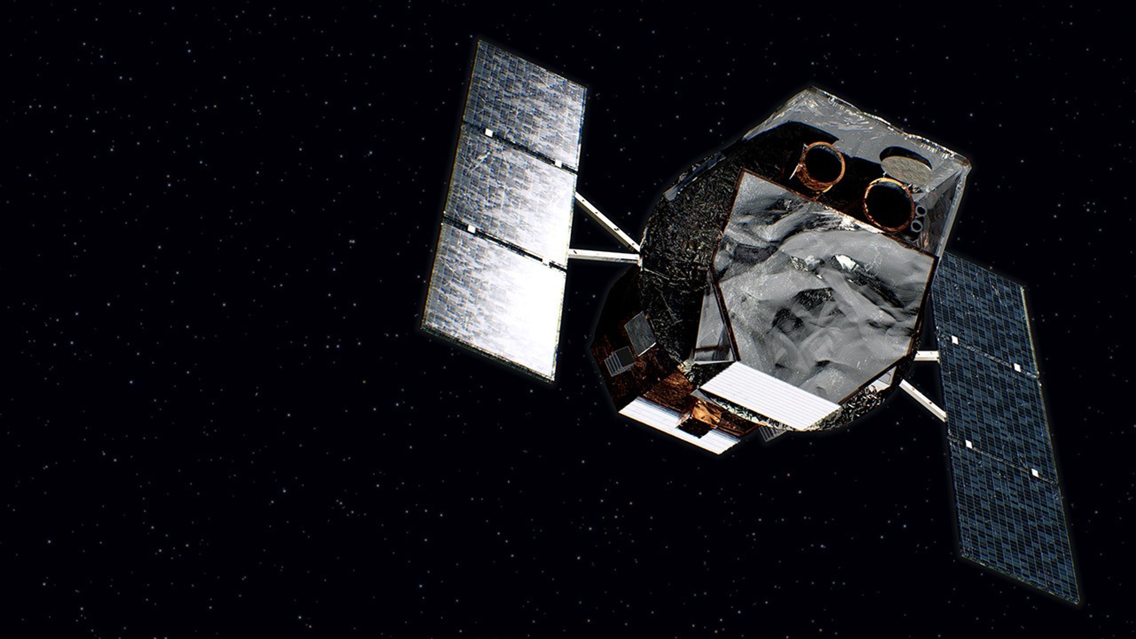
An artist’s concept of NASA’s Neil Gehrels Swift Observatory.
NASA’s Goddard Space Flight Center/Chris Smith (KBRwyle)

Swift boost facts

ContractorKatalyst Space in Flagstaff, Arizona
Launch vehicleNorthrop Grumman’s Pegasus XL rocket
Launch locationKwajalein Atoll, Marshall Islands
Launch dateJune 2026
Servicing vehicleKatalyst’s LINK spacecraft
A 880 pound (400 kilogram) small satellite
Uses three robotic arms to dock with Swift
Controlled rendezvous validated with a full-scale Swift model in a robotic testbed
Precision guidance, navigation, and control
Graphical timeline of the Swift boost mission.
Katalyst Space’s LINK spacecraft will take several months to complete the Swift orbit boost, as outlined in this timeline. In the artist’s concept, LINK is the smaller of the two spacecraft. 
Katalyst Space and NASA’s Goddard Space Flight Center
Ultraviolet Portrait of the Andromeda Galaxy from Swift
This mosaic of M31 merges 330 individual images taken by the Ultraviolet/Optical Telescope aboard NASA’s Swift spacecraft. It is the highest-resolution image of the galaxy ever recorded in the ultraviolet. The image shows a region 200,000 light-years wide and 100,000 light-years high.
NASA/Swift/Stefan Immler (GSFC) and Erin Grand (UMCP)

Swift spacecraft facts

Launch dateNov. 20, 2004
TypeMedium-class Explorer Mission
InstrumentsBurst Alert Telescope, Ultraviolet/Optical Telescope, X-ray Telescope
Collaborating AgenciesItalian Space Agency (ASI); UK Space Agency
Collaborating InstitutionsPennsylvania State University, Mullard Space Science Laboratory, University of Leicester, Brera Observatory, ASI Data Center, Los Alamos National Laboratory
Mission ManagementGoddard Space Flight Center, Greenbelt, Maryland
Program ManagementNASA’s Space Science Mission Operations
Mission OperationsPenn State Eberly College of Science, State College, Pennsylvania
Photo of technicians working on the Swift spacecraft.
In July 2004, technicians in Hangar AE at what is now Cape Canaveral Space Force Station, Fla., removed the final pieces of protective covering from the Swift spacecraft in preparation for its November 2004 launch.
NASA

Press contacts

Alise Fisher, public affairs, NASA Headquarters

Karen Fox, public affairs, NASA Headquarters

Sarah Bradley, media contact, Katalyst Space

Brigitte Sprague, communications lead, Northrop Grumman

Gail McCormick, communications, Penn State Eberly College of Science

Resources

People maneuver a spacecraft into a large chamber.

Swift Boost Fact Sheet

People in cleans suits work on a spacecraft in a large chamber.

Swift Boost Page

Additional information and resources for the Swift boost

A spacecraft against a black background

Swift Blog

Updates and progress reports on the Swift boost mission

Swift Multimedia Gallery

Videos and imagery related to the Swift mission and its science

Photo of technicians working on the Swift spacecraft.

NASA Image and Video Library

Historical photos and video of Swift

NASA's Swift spacecraft spots its thousandth gamma-ray burst.

Swift News & Feature Stories

Swift science highlights

Illustration of the LINK and Swift satellites

Katalyst Space News

News from Katalyst Space

Photo of Northrop Grumman’s Stargazer aircraft with a Pegasus XL rocket attached.

Pegasus XL rocket info

Additional information on Northrop Grumman’s Pegasus XL rocket

Keep Exploring

Discover More Topics From NASA

The post Swift Boost Media Resources appeared first on NASA Science.

  •  

Helio and You: May 2026

Earth has four seasons: spring, summer, fall, and winter. Other planets can experience seasons, too, but they might be wildly different from the ones that we are used to. This article explores the relationship between stars and the seasons experienced by the planets which orbit them, and is connected to educational resources that help K-12+ teachers explain seasonal changes and related concepts in simple, engaging ways for students.

Find the article here ↗

The post Helio and You: May 2026 appeared first on NASA Science.
  •  

NASA Satellites Help Map Ocean Nutrient Stress 

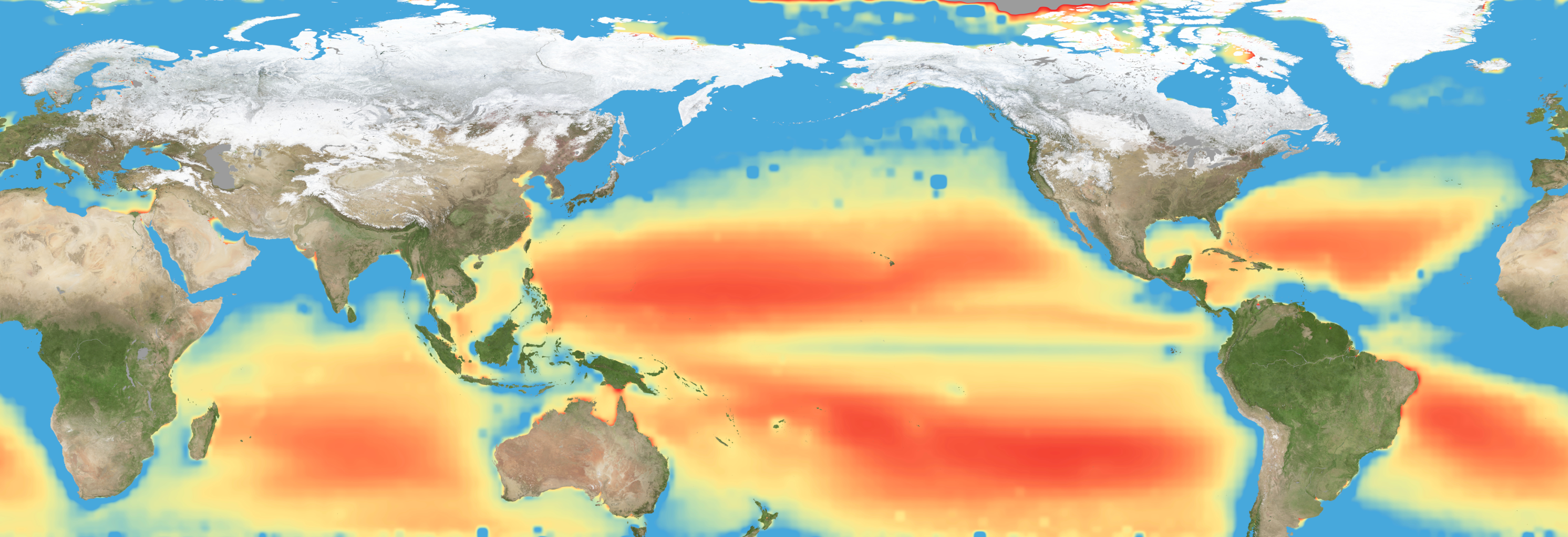
A flat map of the world shows regions in the ocean colored red to indeicate elevated levels of stress on plankton due to a lack of nutrients.
Warming waters decrease upwelling and lead to stress on marine microorganisms due to limited availability of vital nutrients. Red indicates the regions of highest nutrient-related stress.
Kel Elkins/NASA’s Scientific Visualization Studio

Editor’s note: This article was updated on June 5.

A new study combining NASA satellite observations, ocean surveys, and genetic testing on marine microorganisms found evidence that warming ocean waters may be limiting nutrient availability across much of the global ocean. The researchers report that this nutrient stress affects microscopic marine organisms and could influence marine ecosystems over time.

The research, published June 5 in Science Advances, tracked the condition of phytoplankton, which form the base of ocean food webs. Rather than measuring nutrients like nitrogen, iron, and phosphorus directly, the researchers inferred stress by tracking subtle shifts in the ratio of carbon to chlorophyll in phytoplankton observed from space. When the amount of chlorophyll decreases relative to carbon as seen in satellite data, it’s an indication that the plankton are stressed. 

“As our ocean continues to change, the ability to observe and track ocean conditions through sustained, high quality remote sensing observations has never been more important,” said Laura Lorenzoni, Program Scientist for NASA’s Ocean Biology and Biogeochemistry Program at NASA Headquarters in Washington. “This is fundamental, as plankton communities are the base of the marine food web on which important economic activities rely.” 

The research team combined two decades of data from NASA’s Aqua satellite’s Moderate Resolution Imaging Spectroradiometer (MODIS) sensor with plankton samples collected on research cruises around the world. The approach linked large-scale satellite observations with genetic markers in Prochlorococcus, a tiny but abundant marine microbe that shows signs of nutrient stress in its DNA. The result is a global map revealing where phytoplankton are thriving and where they’re struggling. 

Ocean chlorophyll, as observed with NASA's Moderate Resolution Imaging Spectroradiometer (MODIS) instrument between January 2010 through May 2016.
Marit Jentoft-Nilsen/NASA's Goddard Space Flight Center

The strongest indications of nutrient stress on plankton appeared in the subtropical gyres, which are vast, relatively calm regions of the Atlantic, Pacific, and Indian oceans. In these areas, a layer of warm surface water stifles the flow of colder water from deeper in the ocean.  

“When the surface of the ocean warms, it generates this very stable situation where a layer of low-density water sits on top of higher-density cold water,” said study coauthor Adam Martiny, an oceanographer at the University of California, Irvine. “You’ve probably experienced that if you’ve ever been to a lake in the summertime—it’s super warm right on the surface, and very cold deeper down when you stick your legs in.” 

This layering blocks the upward flow of nutrient-rich water, limiting the availability of ocean surface nutrients that are crucial for plankton. In the South Pacific, one of the most nutrient-poor regions, a layer of warm surface water contributed to nitrogen and iron shortages, producing the most severe nutrient-related stress that the team discovered. 

But the researchers were surprised to find that parts of the North Atlantic experience less nutrient stress than expected. Although there was evidence of a lack of phosphorus, the impact on microorganisms was comparatively mild. 

That difference may reflect the biology of the organisms themselves. Phytoplankton can partially compensate for phosphorus shortages by recycling phosphorus more efficiently or replacing phosphorus-rich molecules inside their cells. Nitrogen shortages are harder to overcome because nitrogen is crucial for the proteins and cellular machinery required for photosynthesis and nutrient uptake. 

The study revealed that nutrient stress is strongly correlated with seasons and major weather cycles such as El Niño and the Pacific Decadal Oscillation, which lead to warming waters in the Pacific Ocean. During La Niña events, which cool water over a large part of the Pacific, stronger upwelling brought more nutrients to surface waters and reduced stress in some regions. Superimposed on those multi-year cycles, however, was a longer-term trend. 

From 2002 through 2021, average sea-surface temperatures increased across nearly 90% of the ocean area examined in the study. Over the same period, nutrient stress generally intensified, consistent with previous hypothesis that warming oceans may become increasingly stratified and less able to replenish surface nutrients. 

In many nutrient-poor regions of the Southern Hemisphere, however, the researchers found evidence that nutrient stress had not increased as much as expected despite significant warming. They suspect that microbes capable of capturing nitrogen from the air may partially offset the effects of reduced nutrient mixing. 

That finding hints that marine ecosystems may possess more resilience to warming climates than some models predict. It also underscores the complexity of forecasting how ocean biology will respond to continued warming. 

“We have two really powerful tools,” said study coauthor Michael Behrenfeld, a biochemist with Oregon State University in Corvallis, Oregon. The tools include satellite observations and cellular studies. “Both produce big data sets, but they are kind of opposites. We have very detailed data about microscopic phytoplankton … and then we have global coverage with satellites.”   

By combining satellites that monitor the entire ocean with genetic clues carried inside microscopic plankton, the researchers say they are gaining a new way to track biological responses to changing environmental conditions near real time. 

By James Riordon
NASA’s Earth Science News Team

Media contact: Elizabeth Vlock
NASA Headquarters

About the Author

James Riordon

James Riordon

Senior Science Writer

The post NASA Satellites Help Map Ocean Nutrient Stress  appeared first on NASA Science.
  •  
❌