A giant blob of abnormally cold water in the North Atlantic Ocean is shifting the Indian summer monsoon, threatening the livelihoods of more than 1 billion people, new research suggests.
The link between these two systems highlights a previously unrecognized connection that could inform weather forecasts in South Asia and shed light on climatic events elsewhere, scientists say.
The Indian summer monsoon is a rainfall pattern that lasts from June to September and is driven by temperature differences between the warm northern Indian Ocean and cooler seawater below the equator. Historically, the monsoon triggered heavy rainfall along the west coast of India and a huge region of northern India called the Indo-Gangetic Plain. But since 1999, this pattern has changed dramatically, the researchers reported in a new study.
Northwest India now receives about 25% more rain during the monsoon season than it did before 1999, while the Indo-Gangetic Plain gets roughly 4% less, the team found. This is disastrous for farmers, in particular, because their soils and crops are adapted to the old rainfall pattern, said study first author Mahendra Nimmakanti, a climate scientist at the Indian Institute of Science's Centre for Atmospheric and Oceanic Sciences.
"India is largely dependent on agriculture," Nimmakanti told Live Science in a joint interview with study co-author Matthew Huber, a professor in the Department of Earth, Atmospheric, and Planetary Sciences at Purdue University in Indiana. Higher-than-normal precipitation in northwest India is causing flash floods and crop losses, because agriculture in this region is adapted to dry conditions. Meanwhile, the Indo-Gangetic Plain has seen periods of drought that also caused crop declines and impacted farmers' livelihoods, Nimmakanti said.
Previous studies have linked shifts in the Indian summer monsoon to changes in the Atlantic Meridional Overturning Circulation (AMOC), a giant web of ocean currents in the Atlantic that regulates the global climate and carries heat to the Northern Hemisphere. Data suggests the AMOC is slowing due to climate change and releasing less heat in the North Atlantic Ocean than it did before. This may be causing a southward shift of the Intertropical Convergence Zone, a band of low-pressure atmospheric conditions around the equator that drives tropical monsoons, including the Indian summer monsoon.
But these studies didn't specify how the Indian monsoon might shift or explain the underlying mechanism in detail, Nimmakanti said. "They generally explain that if there is a weakening of AMOC, that suppresses the Indian summer monsoon," he said.
One part of the problem is that current climate models do not show the changes in the Indian monsoon that have happened in real life, possibly because they also don't fully capture shifts in North Atlantic sea surface temperatures. This is especially true for a region southeast of Greenland known as the "cold blob," where the water was colder between 1901 and 2021 than it was in the late 1800s, even as the ocean around it heated up.
To pinpoint how and why the Indian monsoon has changed, the researchers fed precipitation data, sea surface temperature records and other real-life observations into dozens of climate models. This reproduced the shifts observed over the past 27 years. However, the results only implied a correlation between shifts in the North Atlantic and changes in the monsoon, not that the former directly caused the latter.
Northwest India now gets 25% more rain during the monsoon season than it did before 1999, and this shift has also increased flooding risk in Pakistan. (Image credit: Sabir Mazhar/Anadolu via Getty Images)
To figure out if North Atlantic sea surface temperatures caused the Indian monsoon to behave strangely, the team added and removed the cold blob in a simulation. The results showed that the cold blob has shifted the Indian monsoon by creating a strong temperature gradient over the North Atlantic, which, in turn, affects jet stream winds and pressure systems in the atmosphere above Eurasia.
Specifically, the jet stream above the North Atlantic has intensified, and a "blocking" system over the Ural Mountains in western Russia has strengthened, Huber said. As a result, weather systems in India have changed, sucking moist air toward the country's northwest and away from other regions.
"It's a shifting of the high- and low-pressure systems," Huber said. "Realizing that these two systems were directly linked through this wave train coming off the North Atlantic, that was novel."
More than 1 billion people in India and other parts of South Asia depend on the monsoon for food security and economic stability. The new results, published April 27 in the journal AGU Advances, could help forecasters predict extreme rainfall and drought events in India and neighboring countries like Pakistan during the monsoon season.
Some researchers think the Indian monsoon is a key tipping point within the global climate, and the findings suggest the system crossed a threshold in 1999. Since then, the cold blob has caused a "persistent jet stream reorganization," leading to abrupt shifts in the monsoon, according to the study.
It's unclear how the Indian monsoon will evolve under intensifying climate change, because climate models produce different predictions of what will happen in the North Atlantic, and other drivers may come into play as the world changes, Huber said.
"What we do now know is that this is one of the key building blocks of formulating a theory for what will happen in the future," he said.
Taming Nature: Inside China's efforts to control the region's water
China is facing water scarcity that affects millions of people, so the country is embarking on water projects on a scale the planet has never seen. This three-part series investigates three elements of this effort: the world's biggest dam, a doomed effort to create a "river in the sky," and a colossal water transfer project.
In southwest China, Chinese soldiers load and fire rockets toward the sky as aircraft and drones circle overhead, dropping their toxic cargo into the air. The weapons are not trained on an enemy, and the planes aren't dropping bombs. Instead, they are targeting the clouds hovering in the sky.
This footage is just a tiny snapshot of the massive, countrywide effort to seed the clouds with rain at an unprecedented scale.
More than 50 countries around the world use cloud seeding to modify the weather at small scales, including the United States.
China has been using and expanding cloud seeding for decades. This images from 2011 shows cloud-seeding shells being fired into the sky in Hubei Province, central China. (Image credit: Getty Images)
But China is the world leader, employing around 50,000 people; using thousands of rocket launchers and dozens of planes; and investing the equivalent of billions of dollars in these initiatives, experts told Live Science.
In 2018, China embarked on its most ambitious cloud seeding plan. The Tianhe ("Sky River") project aimed to create a permanent airborne water "corridor" from one river basin to another on the Tibetan Plateau. The project was intended to be part of the country's much bigger South-North Water Transfer project — a massive effort to transfer water to China's highly populated and water-scarce North and East.
From the start, the Sky River faced scathing criticism from scientists who said the project was unworkable. Yet China forged ahead.
China's pursuit of such a scientifically questionable geoengineering technology shows just how far Chinese authorities are prepared to go to achieve the country's water and climate goals. It also reveals how the Chinese government views the natural world, experts have said.
"There is an impetus to control and to view the environment as a machine or an infrastructure that can be controlled," Emily Yeh, a professor of geography at the University of Colorado Boulder, told Live Science.
The science of cloud seeding
China uses cloud seeding to produce precipitation to build up snowpack, help alleviate droughts, reduce the impact of hailstorms, and create skies clear of clouds and pollution for official events — as it did most famously during the 2008 Beijing Olympics, experts told Live science.
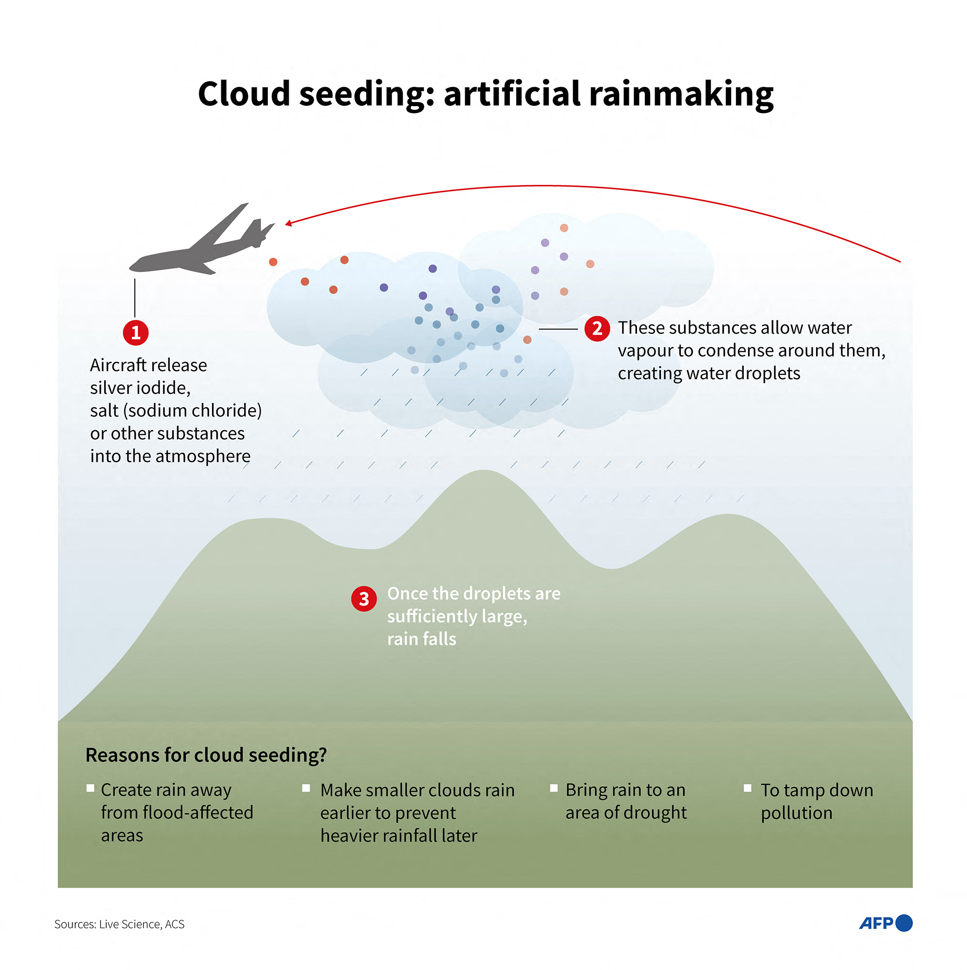
But cloud seeding can't create rain from an empty sky. Instead, it causes existing clouds to generate precipitation more efficiently by injecting particles into a cloud. Water droplets then coalesce around these particles, and the water eventually falls as rain or snow.
"Every single drop in any cloud you have ever seen — there's a particle in it," Rob Rauber, an atmospheric scientist at the University of Illinois Urbana-Champaign, told Live Science. Cloud seeding speeds up the raindrop-forming process by introducing more particles, he explained.
This illustration shows, in simple terms, how cloud seeding works. (Image credit: LAURENCE CHU via Getty Images)
There are two main ways to do this, depending on whether the temperature of the clouds is above or below 32 degrees Fahrenheit (0 degrees Celsius). Warm-cloud seeding is known as hygroscopic seeding, while cold-cloud seeding is called glaciogenic seeding.
"They have the same general goals or approach," Jeff French, head of atmospheric science at the University of Wyoming, told Live Science. "And that is to introduce something into the cloud that would increase the efficiency in which cloud droplets or ice crystals are able to grow to precipitation-size particles and fall out of cloud either as rain or as snow."
A salt such as sodium chloride is typically used for hygroscopic seeding to attract water droplets, French said. Glaciogenic seeding, by contrast, takes advantage of cold clouds' supercooled water — water that is liquid even when temperatures are below freezing — by introducing silver iodide. This substance has a similar structure to ice and collides with supercooled water in a cloud, causing it to freeze and eventually fall from the cloud, French said.
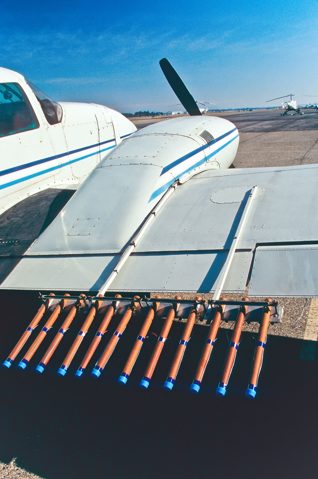
Scientists insert seeding particles into clouds in a number of ways, including by dropping them from planes and drones, firing shells or rockets into the clouds from the ground, or burning materials in chambers that release the combustion byproducts into the air.
Scientists are still learning exactly when and how to use these techniques most effectively. Rauber and French both noted that it's difficult to quantify cloud seeding's impact.
"It becomes kind of a quagmire when you ask that question: 'Does cloud seeding work?'," French said. For his research, he used airplanes, ground sensors and radar across the U.S. Mountain West to measure the effects of seeding from aircraft on the initiation and growth of crystals and eventual snowfall. "From a physical standpoint, I can say very confidently that cloud seeding works," French said.
However, that experiment was in cold, mountainous conditions, and the impact of cloud seeding depends on many conditions, so tracking whether cloud seeding increases precipitation over a longer period and in different conditions can be challenging.
Science Spotlight
(Image credit: Marilyn Perkins / Future)
Science Spotlight takes a deeper look at emerging science and gives you, our readers, the perspective you need on these advances. Our stories highlight trends in different fields, how new research is changing old ideas, and how the picture of the world we live in is being transformed thanks to science.
"Not all clouds are created equal," French said. Some are colder or warmer, and the seeding material won't work as well; in others, the size or distribution of droplets makes precipitation less likely. Even within a small region, the snowfall varies tremendously from one point to another. And beyond a small region, all bets are off.
"If you have a very successful cloud seeding program, that is producing, maybe 7% or 9% or even 10% more precipitation over a mountain range, downstream of that mountain range, the impact may be 1%," French said. "But it is a really difficult number to get our arms around."
French added that scientists should be careful to not overpromise what cloud seeding can accomplish.
"If the promise is that cloud seeding is going to eliminate droughts even on a local level, the answer is no, it can't live up to that. There's no scientific evidence," French said. But if targeted properly, it can moderately increase natural precipitation, he said.
Cloud seeding on the Tibetan Plateau
Despite cloud seeding's limitations, China has established weather modification bureaus across the country.
"They have a whole campus of people who are working in the weather modification field," Rauber said. "They have a fleet of aircraft — they're on a whole different scale than anything that goes on anywhere else in the world."
Chinese researchers claim that the country has made huge strides in its weather modification. Reports from state-owned media suggested that weather modification efforts increased precipitation by 168 billion tons between 2020 and 2025, and that in experiments, just one cup of cloud seeding material generated 30 Olympic-size pools' worth of precipitation over an area the size of Yellowstone National Park in the arid Xinjiang region.
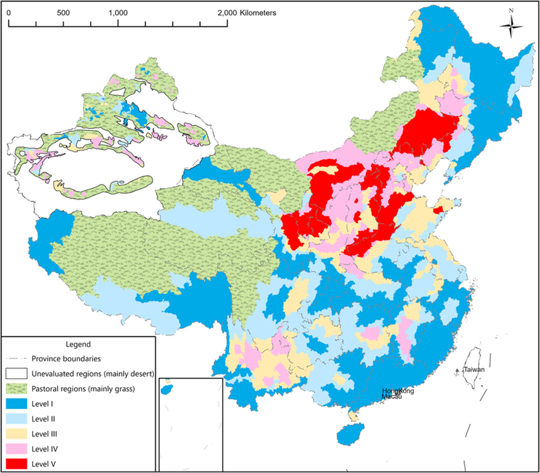
A map showing water scarcity in various regions of China. (Image credit: Kong et al. (2021), CC BY-NC-ND 4.0)
These weather modifications have also been conducted on the Tibetan Plateau. The vitally important region, nicknamed Asia's Water Tower, is the source of multiple major rivers that supply water to nearly 2 billion people across Asia. But the plateau is facing increasing desertification and glacier loss due to human-caused climate change and other human activities such as overgrazing animals.
China's cloud-seeding ambitions for the plateau reached a whole new level in 2018, when authorities announced the Sky River project. The controversial project aimed to use cloud seeding to create precipitation across a 620,000-square-mile (1.6 million square kilometers) area in the Tibetan Plateau — about the size of Alaska — to divert Indian monsoon rains above the Yangtze River basin and channel the water to the Yellow River basin. From the Tibetan Plateau, the Yellow River flows north and east into the parched northern regions of China, while the Yangtze flows south and east into less-water-scarce areas. The initial plan claimed the project would transfer up to 7% of the country's total annual water consumption, reports noted.
The atmospheric channel was intended to be part of the country's colossal South-North Water Transfer Project, circumventing the region's challenging terrain by moving the water in the sky instead.
The plan, due to be completed in 2025, called for seeding this atmospheric river using tens of thousands of silver iodide-burning chambers on the ground, linked to a series of meteorological satellites that would analyze the weather conditions. Information from these satellites would automatically trigger the burners when the conditions were suitable for cloud seeding.
Cloud seeding takes place in more than 50 countries, including in the U.S. Here, a plane in California is about to take off with pyrotechnic silver iodide flares. (Image credit: inga spence via Alamy)
However, the plan was immediately met with a barrage of criticism from scientists in China. In a translated statement, Hancheng Lu, a professor at the National University of Defense Technology's School of Meteorology and Oceanography, called the project "an absurd and fantastical project with neither scientific basis nor technological feasibility."
The project was unworkable because it is not possible to convert all atmospheric moisture to rain, or to channel moisture in this way, Yeh said.
As of 2022, researchers were working on a significantly scaled-back version of the project. However, China's official channels have gone dark on the topic.
China's newly announced five-year plan, which sets out the policy direction of the country from 2026 to 2030, references weather modification enhancements but doesn't mention this specific project, according to reports from Chinese media.
This has led experts to speculate that the project was quietly canceled.
"When one goes to China and asks atmospheric scientists not involved in it about it, they just sort of laugh, and it's like this embarrassing incident," Yeh said. "It was never possible."
To see whether the project was still going forward, Live Science reached out to several researchers involved in the project, but they did not reply by the time of publication.
The fears of cloud seeding
The pursuit of the Sky River project — despite the low likelihood that it would ever work —— has caused significant alarm in neighboring countries. India relies on the monsoon rains and rivers such as the Brahmaputra, which starts in the Tibetan Plateau before flowing through India and Bangladesh on a 1,800-mile-long (2,900 km) route to the sea. There are also suspicions about cloud seeding being used to cause flooding across borders.
Many of these fears are overblown, experts told Live Science. Rauber noted that cloud seeding can't influence weather enough to reduce water in a wider weather system.
"This is always a question of, 'Are you robbing Peter to pay Paul?'" Rauber said. But the amount of water in storm clouds "is way greater than anything cloud seeding is going to extract."
Climate geoengineering
China's all-in pursuit of technologies like cloud seeding — even on the internationally important and politically sensitive Tibetan Plateau — has raised concerns that China is prepared to go to extreme lengths to engineer its way out of its problems — even when it involves scientifically dubious geoengineering projects with massive risks.
This may even involve attempts to change how much sunlight reaches the planet's surface, experts have speculated.
"Given similarities, weather modification could serve as a means to incrementally build legitimacy for solar radiation management, in China and beyond, which may ultimately make it possible to deploy it," researchers argued in a 2019 study.
However, there's no evidence that China is currently pursuing such climate modifications, and it's unlikely they'd do so without some cooperation or buy-in from other countries, researchers wrote in 2023.
"It is currently unlikely that China would deploy SRM unilaterally. But its weather modification programme does demonstrate the country's willingness and capability to undertake large-scale atmospheric intervention projects," the study authors wrote.
Solar radiation modification aims to release particles such as sulfur high into the atmosphere to reflect sunlight back into space in an effort to limit global heating. It is being increasingly investigated by researchers and governments. The controversial concept has never been demonstrated on a large scale, and studies suggest it has many potential risks, such as the potential to shut down monsoon rains.
Scientists have already seen some of the negative impacts of natural solar radiation modification, for instance in the aftermath of large volcanic eruptions, such as Tambora in 1815. "It led to the suppression of the monsoon, because the monsoon is driven by heating from the sun, Rauber said. "And that cuts back on rain in tropical areas, and that causes droughts, which causes all sorts of diseases and can lead to mass starvation," he added.
"The evidence from nature is don't mess with Mother Nature," he said.
Lucid has registered the design of its upcoming Cosmos with the European Union Intellectual Property Office, giving us the clearest look yet at the sub-$50,000 crossover the automaker is betting its future on.
The filing, published last week, shows the production design of Lucid’s first mass-market EV from every angle, inside and out, months before its expected reveal this summer.
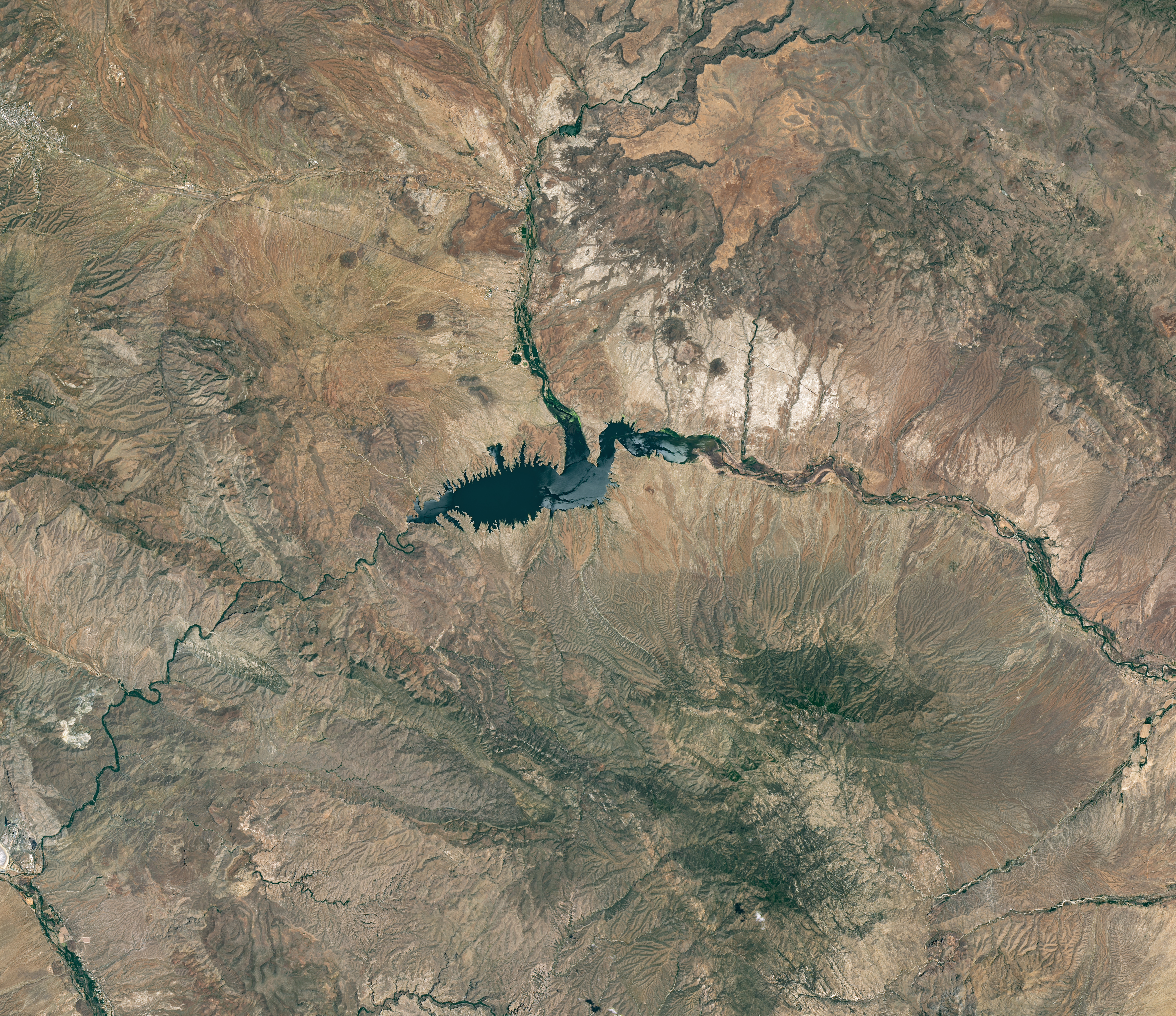
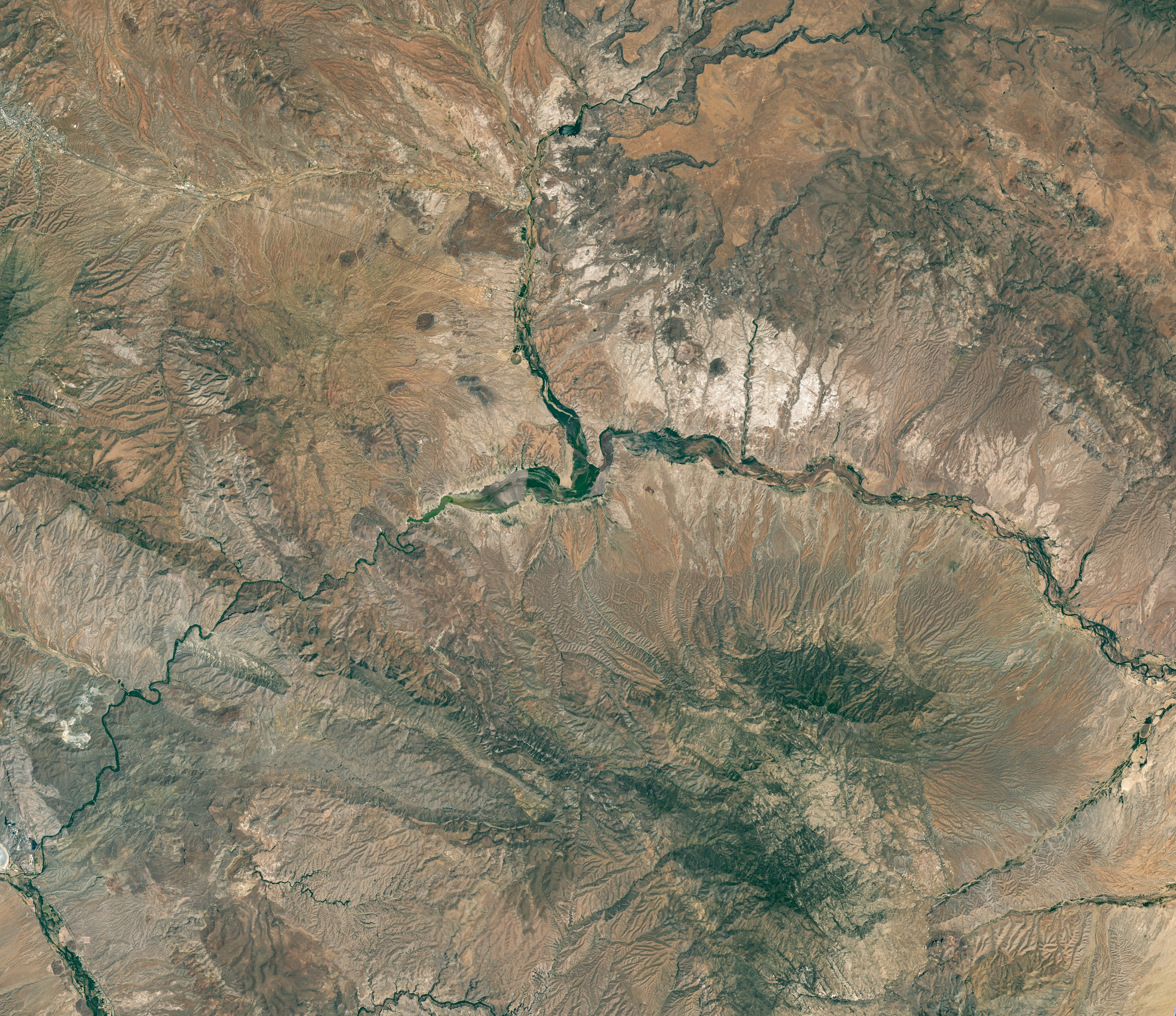
The reservoir appears lake-like and expansive in an image acquired in June 2023.
NASA Earth Observatory/Michala Garrison
The reservoir is nearly empty by May 2026. The Gila River’s natural channel is now visible and flanked with green vegetation in what had been the bottom of the reservoir.
NASA Earth Observatory/Michala Garrison
June 7, 2023
May 22, 2026
Little water remains in the San Carlos Reservoir in May 2026 (right) compared to fuller conditions in June 2023 (left). Images were captured by the OLI (Operational Land Imager) on the Landsat 9 and 8 satellites, respectively. NASA Earth Observatory images by Michala Garrison.
The Gila River is among the Southwest’s most important rivers, delivering water for people, farms, and wildlife while linking the snow-fed mountains of southwestern New Mexico to the desert lowlands of southwestern Arizona.
In wetter years, seasonal snowfall on the Mogollon Mountains and Black Range provides much of the river’s spring flow and helps refill San Carlos Reservoir, which is formed by the Coolidge Dam. When filled to capacity, the reservoir is one of Arizona’s largest bodies of water.
However, in 2026, lackluster snowfall left the mountain snowpack in the Gila River watershed at 2 percent of the 1991-2020 March median. The limited snowpack pushed April streamflow to 39 percent of normal. By June, after mandatory water releases for downstream agriculture, the reservoir held less than 400 acre-feet of water.
The Landsat image above (right) shows the near-empty reservoir on May 22, 2026, when it stored 389 acre-feet of water—less than 1 percent full; the other image (left) shows the same area in June 2023, when it was about 60 percent full. The green vegetation growing along the river channel and reservoir edge includes a mixture of tamarisk, willow, cottonwood, sedges, and grasses.
Officials closed the reservoir indefinitely on June 5, 2026, after the declining water levels contributed to low oxygen levels—hypoxia—that killed virtually all of its fish. Species living in the reservoir included largemouth bass, black crappie, bluegill, channel catfish, flathead catfish, and several stocked species, including brown trout and rainbow trout. The decomposing fish may pose health risks to people attempting to boat or fish, the San Carlos Recreation and Wildlife Department warned.
The reservoir has hit similarly low water levels in the past, running out of water at least 20 times since it was filled in 1930, according to news reports. Even when the dam and reservoir were first dedicated, there was enough grass growing on the dried reservoir bottom that humorist Will Rogers famously quipped to President Calvin Coolidge: “If that was my lake, I’d mow it.”
Other years with major fish kills include 1976 and 2018. After more than 5 million fish died during a similar event in 1976, the Gila Heraldreported that it took five years for the lake’s ecosystem to rebound.
The region is currently in the midst of a multi-year dry period that has left much of the Gila River’s headwaters in New Mexico in a state of severe drought, according to data from the U.S. Drought Monitor.
However, the river’s flow is highly variable, and heavy rains during the coming wet season could help the reservoir recover. A seasonal monsoon outlook released by NOAA in May 2026 projected a 33 to 50 percent chance that an above-average amount of rain would fall in the region that summer. El Niño in the central and eastern equatorial Pacific, which was strengthening in late spring 2026, can make heavy rains in the U.S. Southwest more likely.
NASA Earth Observatory images by Michala Garrison, using Landsat data from the U.S. Geological Survey.Story by Adam Voiland.
The reservoir appears lake-like and expansive in an image acquired in June 2023.
NASA Earth Observatory/Michala Garrison
The reservoir is nearly empty by May 2026. The Gila River’s natural channel is now visible and flanked with green vegetation in what had been the bottom of the reservoir.
NASA Earth Observatory/Michala Garrison
June 7, 2023
May 22, 2026
Little water remains in the San Carlos Reservoir in May 2026 (right) compared to fuller conditions in June 2023 (left). Images were captured by the OLI (Operational Land Imager) on the Landsat 9 and 8 satellites, respectively. NASA Earth Observatory images by Michala Garrison.
The Gila River is among the Southwest’s most important rivers, delivering water for people, farms, and wildlife while linking the snow-fed mountains of southwestern New Mexico to the desert lowlands of southwestern Arizona.
In wetter years, seasonal snowfall on the Mogollon Mountains and Black Range provides much of the river’s spring flow and helps refill San Carlos Reservoir, which is formed by the Coolidge Dam. When filled to capacity, the reservoir is one of Arizona’s largest bodies of water.
However, in 2026, lackluster snowfall left the mountain snowpack in the Gila River watershed at 2 percent of the 1991-2020 March median. The limited snowpack pushed April streamflow to 39 percent of normal. By June, after mandatory water releases for downstream agriculture, the reservoir held less than 400 acre-feet of water.
The Landsat image above (right) shows the near-empty reservoir on May 22, 2026, when it stored 389 acre-feet of water—less than 1 percent full; the other image (left) shows the same area in June 2023, when it was about 60 percent full. The green vegetation growing along the river channel and reservoir edge includes a mixture of tamarisk, willow, cottonwood, sedges, and grasses.
Officials closed the reservoir indefinitely on June 5, 2026, after the declining water levels contributed to low oxygen levels—hypoxia—that killed virtually all of its fish. Species living in the reservoir included largemouth bass, black crappie, bluegill, channel catfish, flathead catfish, and several stocked species, including brown trout and rainbow trout. The decomposing fish may pose health risks to people attempting to boat or fish, the San Carlos Recreation and Wildlife Department warned.
The reservoir has hit similarly low water levels in the past, running out of water at least 20 times since it was filled in 1930, according to news reports. Even when the dam and reservoir were first dedicated, there was enough grass growing on the dried reservoir bottom that humorist Will Rogers famously quipped to President Calvin Coolidge: “If that was my lake, I’d mow it.”
Other years with major fish kills include 1976 and 2018. After more than 5 million fish died during a similar event in 1976, the Gila Heraldreported that it took five years for the lake’s ecosystem to rebound.
The region is currently in the midst of a multi-year dry period that has left much of the Gila River’s headwaters in New Mexico in a state of severe drought, according to data from the U.S. Drought Monitor.
However, the river’s flow is highly variable, and heavy rains during the coming wet season could help the reservoir recover. A seasonal monsoon outlook released by NOAA in May 2026 projected a 33 to 50 percent chance that an above-average amount of rain would fall in the region that summer. El Niño in the central and eastern equatorial Pacific, which was strengthening in late spring 2026, can make heavy rains in the U.S. Southwest more likely.
NASA Earth Observatory images by Michala Garrison, using Landsat data from the U.S. Geological Survey.Story by Adam Voiland.
Researchers explored how different dietary changes could reduce the carbon footprint of food consumption. A single change at the dinner table could have a bigger climate impact than many people realize. Researchers in the UK found that replacing just one beef steak per week with salmon could significantly reduce food-related carbon emissions over time. In [...]
Researchers found that a magma’s thermal history may be a key factor in determining whether an eruption becomes more vigorous or remains relatively gentle. What happens deep beneath a volcano can determine whether an eruption unfolds as a slow-moving lava flow or explodes into towering fountains of molten rock. New research suggests that one overlooked [...]

 Login