The EU has claimed "insurance as usual is not sustainable" in the era of climate change, but it's really just an excuse for Brussels to build a climate protection racket, warns Dr Tilak Doshi.
How 2 US, European Satellites Are Studying Hurricanes During El Niño
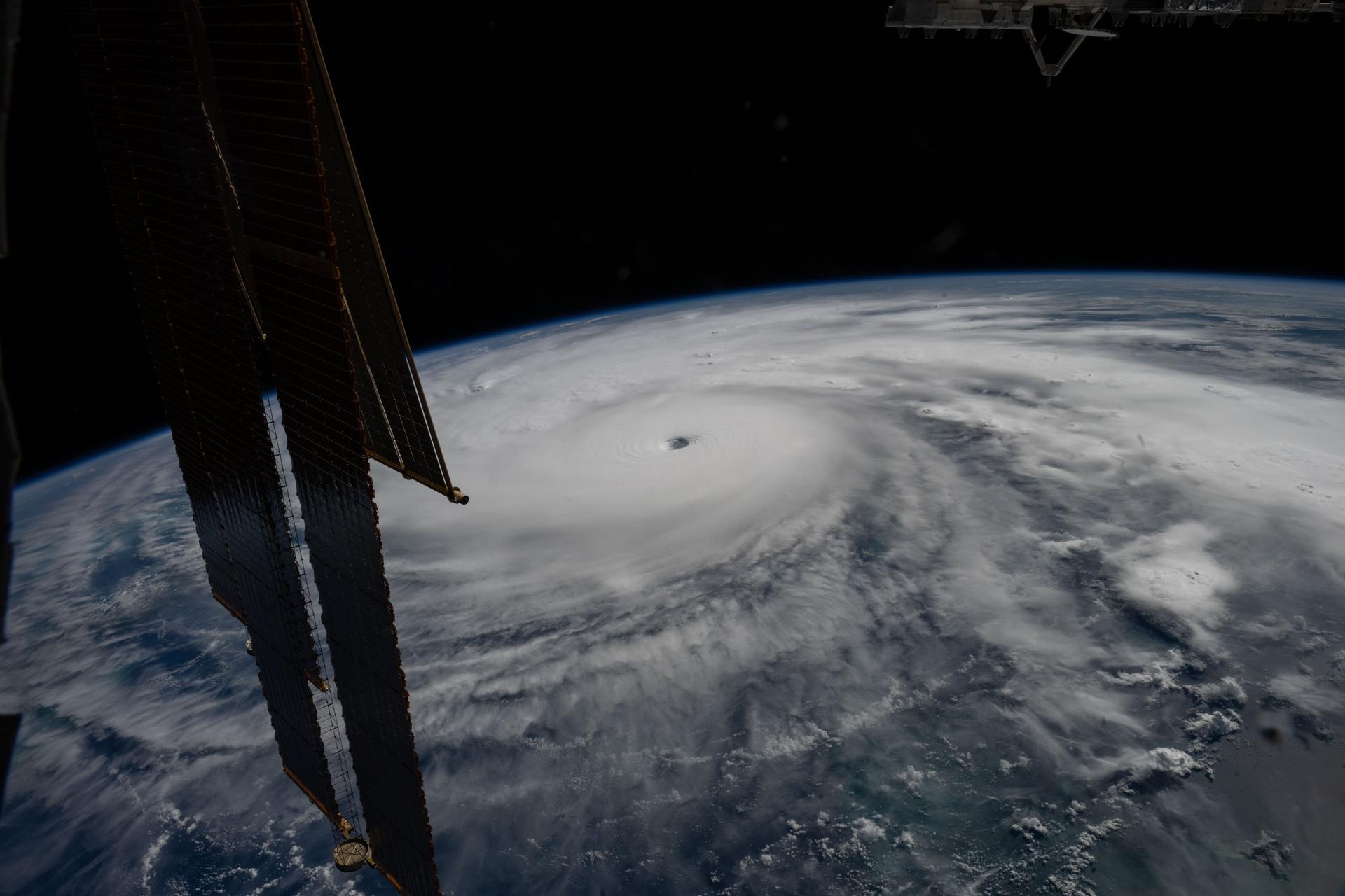
Hurricane Melissa is seen 50 miles south of Jamaica in this photograph taken from the International Space Station on Oct. 28, 2025.
NASA
Last November, NASA and its European partners launched the Sentinel-6B satellite to improve hurricane forecasts, help protect infrastructure, and benefit commercial industries, including shipping. The satellite now is flying 30 seconds behind its predecessor, Sentinel-6 Michael Freilich. Both satellites are providing precise sea level height measurements during what oceanographers expect to be a historic El Niño, a naturally occurring oceanic phenomenon in which warmer-than-usual Pacific waters shift global weather patterns.
The two satellites make up the Copernicus Sentinel-6/Jason-CS (Continuity of Service) mission, the latest in a series of ocean-observing radar altimetry missions that have been monitoring Earth’s changing seas continuously since the early 1990s.
The data each satellite is collecting will not only allow scientists to better understand this year’s El Niño but will also help them create more accurate hurricane predictions.
“This El Niño was a late-bloomer,” said Josh Willis, Sentinel-6B’s project scientist at NASA’s Jet Propulsion Laboratory in Southern California. “It didn’t kick off until the middle of the year and is just now reaching a strength similar to what we’ve seen in the satellite record during significant El Niños in 1997 and 2015. We expect it to be big, and it’s already having big impacts.”
El Niños generally scramble weather patterns tied to rainfall and storms, including hurricanes. They also redistribute heat in the ocean, which affects sea level. Normally, Earth’s warmest ocean waters sit along the equator in the western Pacific. During El Niño, weakened winds, which usually blow westward along the equator, result in heat spreading east toward South America. The change in ocean heat shifts hurricane activity from the Atlantic to the Pacific Ocean.
Predicting hurricane strength
On July 15, Sentinel-6B began delivering low-latency data to scientists that could be used for weather predictions. That data will take some time to work its way into the research models on which meteorologists and climate scientists rely, but when it does, those improved models could save lives.
Data from Sentinel-6 satellite missions feeds into hurricane tracking algorithms used by federal and state agencies. Those predictions can activate disaster response efforts, mobilizing resources ranging from sandbag placement to National Guard activation. They also can lead to evacuation orders that require quick but well-informed decisions about logistics at a local level. More severe events may require engaging larger organizations, such as the Federal Emergency Management Agency.
A tropical storm can take a week or more to become a hurricane and make its way to a coastline, but a hurricane can rapidly intensify in the 48 hours prior to landfall, leaving planners little time to prepare.
“Hurricanes have been known to speed up quickly at the last moment, so the window in which to decide what to do is short,” said Deirdre Byrne, an oceanographer and altimetry expert with the National Oceanic and Atmospheric Administration (NOAA). “The goal is to forecast how much and how rapidly intensification will happen so that officials can make the right calls.”
Each Sentinel-6 satellite measures ocean height, as well as the size of waves and marine wind speed, using a radar altimeter, which bounces thousands of radar pulses a second off the crests and troughs of waves. Ocean height varies from place to place and provides insight into the ocean’s heat content, since warm water expands. That, in turn, helps forecast how fast hurricanes will grow.
Among the measurements Sentinel-6 is gathering, Byrne is most anticipating the ocean height data, which she plans to begin incorporating into the current Satellite Ocean Heat Content Suite algorithm by the end of the year.
“In terms of data quality, the Sentinel-6 missions are unparalleled,” Byrne said.
Together, the missions are also extending a precise dataset deep into its fourth decade. This record of sea level observations traces back to the TOPEX/Poseidon mission, which launched in 1992, and continues through to the present day with Sentinel-6 Michael Freilich. Sentinel-6B will take over for its predecessor as the reference satellite for global sea level measurements later this year.
“The key is consistency, measuring the same way, every time,” said Severine Fournier, Sentinel-6B deputy project scientist, JPL. “That’s what lets us predict hurricanes, and, in turn, protect coastal communities and infrastructure.”
More about Sentinel-6B
Sentinel-6 Michael Freilich, named after a former director of NASA’s Earth Science Division, is one of two satellites that compose the Copernicus Sentinel-6/Jason-CS mission.
Sentinel-6/Jason-CS, a part of the European Union’s Earth observation program called Copernicus, was jointly developed by ESA (European Space Agency), EUMETSAT (European Organisation for the Exploitation of Meteorological Satellites), NASA, and NOAA, with funding support from the European Commission and technical support on performance from the French space agency CNES (Centre National d’Études Spatiales). Spacecraft monitoring and control, as well as the processing of all the altimeter science data, is carried out by EUMETSAT on behalf of the European Union’s Copernicus Programme, with the support of all partner agencies.
NASA JPL, a division of Caltech in Pasadena, contributed three science instruments for each Sentinel-6 satellite: the Advanced Microwave Radiometer, the GNSS-RO, and the Laser Retroreflector Array. NASA also contributed launch services, ground systems supporting operation of the agency’s science instruments, the science data processors for two of these instruments, and support for the United States members of the international Ocean Surface Topography Science Team.
Preparations for Next Moonwalk Simulations Underway (and Underwater)
Hurricane Melissa is seen 50 miles south of Jamaica in this photograph taken from the International Space Station on Oct. 28, 2025.
NASA
Last November, NASA and its European partners launched the Sentinel-6B satellite to improve hurricane forecasts, help protect infrastructure, and benefit commercial industries, including shipping. The satellite now is flying 30 seconds behind its predecessor, Sentinel-6 Michael Freilich. Both satellites are providing precise sea level height measurements during what oceanographers expect to be a historic El Niño, a naturally occurring oceanic phenomenon in which warmer-than-usual Pacific waters shift global weather patterns.
The two satellites make up the Copernicus Sentinel-6/Jason-CS (Continuity of Service) mission, the latest in a series of ocean-observing radar altimetry missions that have been monitoring Earth’s changing seas continuously since the early 1990s.
The data each satellite is collecting will not only allow scientists to better understand this year’s El Niño but will also help them create more accurate hurricane predictions.
“This El Niño was a late-bloomer,” said Josh Willis, Sentinel-6B’s project scientist at NASA’s Jet Propulsion Laboratory in Southern California. “It didn’t kick off until the middle of the year and is just now reaching a strength similar to what we’ve seen in the satellite record during significant El Niños in 1997 and 2015. We expect it to be big, and it’s already having big impacts.”
El Niños generally scramble weather patterns tied to rainfall and storms, including hurricanes. They also redistribute heat in the ocean, which affects sea level. Normally, Earth’s warmest ocean waters sit along the equator in the western Pacific. During El Niño, weakened winds, which usually blow westward along the equator, result in heat spreading east toward South America. The change in ocean heat shifts hurricane activity from the Atlantic to the Pacific Ocean.
Predicting hurricane strength
On July 15, Sentinel-6B began delivering low-latency data to scientists that could be used for weather predictions. That data will take some time to work its way into the research models on which meteorologists and climate scientists rely, but when it does, those improved models could save lives.
Data from Sentinel-6 satellite missions feeds into hurricane tracking algorithms used by federal and state agencies. Those predictions can activate disaster response efforts, mobilizing resources ranging from sandbag placement to National Guard activation. They also can lead to evacuation orders that require quick but well-informed decisions about logistics at a local level. More severe events may require engaging larger organizations, such as the Federal Emergency Management Agency.
A tropical storm can take a week or more to become a hurricane and make its way to a coastline, but a hurricane can rapidly intensify in the 48 hours prior to landfall, leaving planners little time to prepare.
“Hurricanes have been known to speed up quickly at the last moment, so the window in which to decide what to do is short,” said Deirdre Byrne, an oceanographer and altimetry expert with the National Oceanic and Atmospheric Administration (NOAA). “The goal is to forecast how much and how rapidly intensification will happen so that officials can make the right calls.”
Each Sentinel-6 satellite measures ocean height, as well as the size of waves and marine wind speed, using a radar altimeter, which bounces thousands of radar pulses a second off the crests and troughs of waves. Ocean height varies from place to place and provides insight into the ocean’s heat content, since warm water expands. That, in turn, helps forecast how fast hurricanes will grow.
Among the measurements Sentinel-6 is gathering, Byrne is most anticipating the ocean height data, which she plans to begin incorporating into the current Satellite Ocean Heat Content Suite algorithm by the end of the year.
“In terms of data quality, the Sentinel-6 missions are unparalleled,” Byrne said.
Together, the missions are also extending a precise dataset deep into its fourth decade. This record of sea level observations traces back to the TOPEX/Poseidon mission, which launched in 1992, and continues through to the present day with Sentinel-6 Michael Freilich. Sentinel-6B will take over for its predecessor as the reference satellite for global sea level measurements later this year.
“The key is consistency, measuring the same way, every time,” said Severine Fournier, Sentinel-6B deputy project scientist, JPL. “That’s what lets us predict hurricanes, and, in turn, protect coastal communities and infrastructure.”
More about Sentinel-6B
Sentinel-6 Michael Freilich, named after a former director of NASA’s Earth Science Division, is one of two satellites that compose the Copernicus Sentinel-6/Jason-CS mission.
Sentinel-6/Jason-CS, a part of the European Union’s Earth observation program called Copernicus, was jointly developed by ESA (European Space Agency), EUMETSAT (European Organisation for the Exploitation of Meteorological Satellites), NASA, and NOAA, with funding support from the European Commission and technical support on performance from the French space agency CNES (Centre National d’Études Spatiales). Spacecraft monitoring and control, as well as the processing of all the altimeter science data, is carried out by EUMETSAT on behalf of the European Union’s Copernicus Programme, with the support of all partner agencies.
NASA JPL, a division of Caltech in Pasadena, contributed three science instruments for each Sentinel-6 satellite: the Advanced Microwave Radiometer, the GNSS-RO, and the Laser Retroreflector Array. NASA also contributed launch services, ground systems supporting operation of the agency’s science instruments, the science data processors for two of these instruments, and support for the United States members of the international Ocean Surface Topography Science Team.
Across the stories today, a common thread emerges: the gap between what protects us on paper and what protects us in practice. Again and again, communities are discovering that designations, promises, and permits only matter when someone is willing to enforce them — and that when systems fail, it’s ordinary people, and often the most vulnerable, who absorb the shock.
Nowhere is that clearer than in Jackson, Mississippi, where a federal appeals court ruled this week that the Constitution guarantees no right to clean water. For residents who have lived through years of contaminated taps and boil-water notices, the decision lands as a gut-punch reminder that legal frameworks haven’t caught up to environmental reality. A similar tension runs through the Guardian’s reporting on datacenter wastewater in Wyoming, where testing turned up a rare, potentially hazardous bacterium, and on English golf clubs, where one in twelve have quietly broken water extraction rules amid growing drought stress. Behind the numbers are real communities adapting in real time — often without knowing what’s actually flowing through their pipes or being pulled from their aquifers.
That same gap between promise and delivery surfaces in the UK’s datacentre boom, which new analysis suggests will produce only a quarter of the jobs once advertised, even as it strains the national grid. It echoes in Georgia, where a once-booming EV manufacturing corridor is hitting turbulence under shifting federal policy — a reminder that industrial transitions built on incentives can be as fragile as the politics that fund them.
Yet the day’s coverage also points to growing momentum around care, restoration, and reckoning. Hurricane Lowell’s damage across Hawaii’s western islands — toppled trees, flooded roads, thousands without power — sits alongside quieter stories of renewal: Gloucestershire’s proposal to reintroduce beavers as a defense against drought and flooding, Douglas Head’s new conservation status on the Isle of Man, and Coventry’s investment in Longford Nature Park. These are small, deliberate acts of stewardship, the kind Wendell Berry spent his life advocating for. His death last week, at 92, feels newly resonant this week — a farmer-poet who insisted that loving a place well was itself a form of environmental action, long before it became policy language.
Farther afield, the human cost of extraction runs deep. In Peru and Brazil, mercury from illegal gold mining is showing up in children’s blood and in fish that families have eaten for generations, forcing painful dietary changes in communities that did little to cause the contamination. In Indonesia, El Niño-fueled fires are pushing orangutans out of burning forests, while in Uttarakhand, India, women — who gather firewood and fodder — are bearing the brunt of increasingly long fire seasons. In Colombia, the Wiwa community’s decision to relocate their village down the mountain is less retreat than adaptation, a recognition that sacred land is changing faster than tradition can hold still.
It’s a reminder that progress and pressure often arrive together — a new spaceport investment in Shetland, a badger vaccination program under scientific scrutiny, a push for a Natural History GCSE to reconnect children with the outdoors. Each represents a small bet on the future, even as larger systems strain under climate and economic pressure.
As the week unfolds, watch whether the Jackson ruling prompts congressional attention, whether Britain’s Green Party succeeds in forcing transparency around ecosystem collapse risks, and whether Gloucestershire’s beavers get their chance to prove that sometimes the oldest solutions are still the best ones.
In Nolan's supposal, the mad scientist takes on the mystique of a wizard. Perhaps this is fitting, given that he sees science and wizardry as the same thing.
Robots slithered like snakes into the rubble of collapsed buildings to search for trapped survivors in the aftermath of Venezuela’s double earthquake disaster.
The so-called snake robots represented a unique technological aid for international search and rescue efforts following two earthquakes that struck Venezuela on June 24, killing more than 5,000 people and leaving behind 16,740 injured. Rescuers from around the world used trained dogs, seismic and acoustic listening devices, video cameras on sticks, or thermal imaging cameras to search for signs of survivors—but the snakebots equipped with a video camera could squeeze through tight spaces to search deep within fallen building debris.
“The reason why snake robots are useful is they can get into tightly packed volumes that machinery and people otherwise cannot, and that's important in search and rescue because we were able to extend the visual reach of the rescue workers in a safe way,” Howie Choset, head of the Biorobotics Lab at Carnegie Mellon University in Pittsburgh, told Ars. “In a sense, you're doing minimally invasive surgery on a structure with a snake robot.”
Across the stories today, a common thread emerges: the growing gap between urgent environmental realities and the systems—political, economic, and social—struggling to keep pace with change.
This tension plays out most starkly in the realm of climate health impacts. New research warns that heat-related hospitalizations could double by 2040, while a super El Niño threatens to deepen global economic inequality through cascading climate disruptions. Behind the numbers are real communities adapting in real time. In Pacoima, a working-class Los Angeles neighborhood sandwiched between highways and heavy industry, residents like Jose Luis Salas are mounting their own defense against air pollution, installing shoebox-sized monitoring devices that track what they breathe daily.
Yet the day’s coverage also points to growing momentum around practical solutions gaining real traction. Solar energy quietly surpassed coal in U.S. electricity generation for the first time this May—a milestone that arrived not through grand announcements but through the steady accumulation of rooftop panels and utility-scale installations. Britain cleared a major bottleneck by offering grid connections to over 700 clean energy projects, while new data reveals the country’s green economy now employs over one million workers across a £100 billion sector.
The stories reveal how environmental challenges are increasingly driving innovation at the community level. In Guatemala’s Western Highlands, approximately 60 communities are reviving ancient Maya agricultural wisdom, creating homemade biopesticides from aromatic plants to replace expensive chemical alternatives. Similarly, 120 women farmers in Malawi’s Chiradzulu district have transformed traditional maize cultivation by adding organic fruits and vegetables now in high demand from urban buyers—though their success is shadowed by a troubling reality: their bees, crucial pollinators for food security, are mysteriously disappearing.
It’s a reminder that progress and pressure often arrive together. Colombia enacted groundbreaking legislation requiring detailed cattle tracking to prevent deforestation-linked beef from reaching markets, while Indonesia’s magnificent hornbills face accelerating threats from both habitat loss and an illegal online pet trade. The contrast illustrates how conservation gains in one area can be undermined by emerging threats in another.
Perhaps most telling is how wealth continues to complicate climate action. New research from Greenpeace reveals that the ultra-rich drive a quarter of global emissions not through private jets—their visible symbols of excess—but through their investment portfolios and asset ownership. Meanwhile, chemical companies are quietly pushing “immunity laws” across 15 states to shield themselves from health-related lawsuits, even as communities bear the costs of environmental damage.
The space program offers its own metaphor for these broader tensions. NASA’s latest astronaut selections for Artemis missions reflect both ambition and limitation—crews training for missions that won’t reach the Moon, while hundreds of women gathered at the AeroWomen conference to prepare for space careers in an industry still taking shape.
As the week unfolds, all eyes will be on whether these parallel tracks—accelerating environmental pressures and emerging solutions—can converge into the systemic changes scientists say are necessary. Today’s stories suggest we’re living through a period when local innovation and global challenges are both intensifying, creating opportunities for breakthrough and breakdown in equal measure.
A powerful 6.1-magnitude earthquake struck the Caribbean waters off Cuba’s coast Monday afternoon, marking the strongest seismic event the region has experienced in nearly 150 years. The significant tremor sent shockwaves far beyond its epicenter, with residents across Florida and parts of Mexico, including the popular resort destination of Cancún, reporting feeling the ground shake.
The earthquake occurred approximately 65 miles northwest of Mantua, Cuba, at a depth of 16 miles beneath the ocean floor, according to the US Geological Survey. This relatively shallow depth likely contributed to the widespread sensation of the tremor across multiple countries and hundreds of miles from the epicenter.
The Caribbean region sits within a complex zone of tectonic activity, where several major fault systems intersect. While earthquakes of this magnitude are rare in the area, the event serves as a reminder of the ongoing geological processes that shape the region’s landscape and coastal environments. The shallow marine location of this earthquake highlights the dynamic nature of the seafloor in the Caribbean basin.
Scientists continue to monitor the area for potential aftershocks, which commonly follow significant seismic events. The widespread reach of Monday’s earthquake—felt across international borders and vast distances—demonstrates how major geological events can impact entire regional ecosystems and coastal communities simultaneously, underscoring the interconnected nature of Caribbean environmental systems.
Across the stories today, a common thread emerges: the growing tension between ambitious climate goals and the messy realities of making change happen on the ground. From Colorado’s largest-ever oil lease sale to federal subsidies flowing toward aging coal plants, the gap between environmental necessity and economic momentum has rarely felt more stark.
The day’s coverage points to growing momentum around innovation, but also the persistent pull of established systems. While virtual power plants gain traction in Massachusetts and Minnesota as states seek clean energy solutions, the federal government simultaneously allocated $700 million to support the struggling coal industry through the Defense Production Act. It’s a reminder that progress and pressure often arrive together, creating policy landscapes that can feel contradictory but reflect the complex economics of energy transition.
Perhaps most telling are the stories of communities caught between these larger forces. In Colorado’s northwestern wilderness, the Bureau of Land Management is opening 156,000 acres of critical wildlife habitat — including migration corridors for the nation’s largest elk herd — to oil and gas drilling. Meanwhile, in the Dominican Republic, 450 families near the Pueblo Viejo gold mine are demanding relocation from what they describe as dangerous pollution, while Canada’s corporate watchdog office remains unstaffed and unable to respond.
These human-scale impacts reveal how environmental challenges increasingly operate across borders and timescales. The Middle East conflict now threatens global food security through fertilizer trade disruptions, while mangrove forests — nature’s carbon guardians for tens of millions of years — face existential pressure from rising seas happening faster than these resilient ecosystems can adapt.
Behind the numbers are real communities adapting in real time. In Nepal’s fertile southern plains, farmer Dhruba Prasai stands guard over his crops every night as wildlife emerges from nearby forests, highlighting the complex relationship between conservation success and agricultural livelihoods. In Norfolk, authorities must consider exhuming a 200-year-old mass grave of sailors as coastal erosion — accelerated by climate change — threatens this historic site.
Yet today’s stories also showcase remarkable resilience and ingenuity. A Kent village transformed itself into a living solar system model to inspire environmental awareness. The stunning turquoise dwarf gecko has rebounded from near-extinction thanks to trade bans and conservation efforts. Amazon communities are pioneering new models for sustainable resource management while protecting some of the world’s last intact forests.
The juxtaposition feels particularly acute in water policy, where federal officials prepare to impose Colorado River management plans if seven states can’t reach agreement, while a Labour politician calls for public ownership of Thames Water amid ongoing environmental concerns. These parallel struggles — one over scarcity, another over stewardship — underscore how water governance has become a defining issue for both climate adaptation and democratic accountability.
As the week unfolds, all eyes will be on whether the Biden administration’s mixed signals on energy policy — supporting both clean innovation and fossil fuel infrastructure — represent a pragmatic transition strategy or a failure to fully commit to climate goals. The stories emerging from frontline communities, from Nepal’s fields to Colorado’s wilderness, suggest that the window for managed, equitable change continues to narrow, making each policy choice increasingly consequential for both people and planet.
What would you grab if you had just minutes to evacuate your home before a wildfire or hurricane struck? Your family photos? A beloved pet? That handmade quilt from your grandmother?
This deeply personal question lies at the heart of the Museum of Unnatural Disasters, a powerful new pop-up exhibit that has opened in Washington DC. The interactive display forces visitors to confront the human reality behind climate change statistics by focusing on the impossible choices people face when extreme weather threatens everything they hold dear.
The museum brings together an unlikely coalition of voices – disaster survivors sharing their harrowing experiences, lawmakers grappling with policy responses, and activists demanding urgent action. Through personal stories and immersive displays, visitors experience what it means to lose a lifetime of memories to rising floodwaters or watch irreplaceable family heirlooms turn to ash in a wildfire.
The exhibit arrives at a critical moment as extreme weather events become increasingly frequent and severe across the United States. By transforming abstract climate data into visceral, emotional experiences, the museum aims to bridge the gap between scientific warnings and public understanding. Rather than overwhelming visitors with statistics about global temperature rise, the display asks them to imagine their own most treasured possessions at risk, making the climate crisis intensely personal and immediate.
En Colombia han ardido más de 500 incendios, incluso en sus delicados y únicos humedales del altiplano, uno de los ecosistemas de más rápida evolución de la Tierra
Más de 500 incendios han ardido en todo el país desde que comenzó 2024, consumiendo al menos 42.000 acres de bosques y pastizales y cubriendo la capital de Colombia, Bogotá, con una nube de humo contaminante.
More than 500 fires have burned across Colombia, including in its delicate and unique highland wetlands, one of the fastest evolving ecosystems on Earth
A woman puts out a forest fire in Bogota on January 25, 2024. This Thursday, Colombia asked the member countries of the United Nations for help to extinguish around thirty forest fires that are ravaging several regions and drowning the capital, Bogota, in smoke.

 Login