❌

Reading view

New Invasion Drivers Define Oral Tumor Front

In a groundbreaking advancement in the battle against oral squamous cell carcinoma (OSCC), researchers have identified novel molecular drivers that sculpt the invasive margins of these aggressive tumors. This insight, published recently in Cell Death Discovery, has the potential to radically redefine our understanding of tumor invasion dynamics and ultimately reshape therapeutic strategies aimed at curbing cancer spread.

Oral squamous cell carcinoma remains one of the most formidable malignancies affecting the head and neck region, notorious for its high rates of local invasion and eventual metastasis, which severely limit patient survival. The study, led by Flores, G., Uaroon, S., Garay, J.A.R., and colleagues, meticulously charts the cellular and molecular landscape at the leading edge of OSCC tumors—the so-called “tumor front”—where cancer cells adopt aggressive phenotypes to infiltrate neighboring tissues.

Prior research has predominantly focused on the bulk tumor mass, leaving the critical tumor front underexplored. By deploying cutting-edge techniques, including spatial transcriptomics and single-cell RNA sequencing, the team successfully delineated distinct subpopulations of tumor cells specialized in invasion. These cells exhibit unique gene expression profiles that confer enhanced motility, extracellular matrix remodeling abilities, and survival under hypoxic conditions, which are instrumental in their invasive behavior.

One of the study’s striking revelations is the identification of hitherto unrecognized molecular “invasion drivers”—key proteins and signaling pathways that orchestrate the repositioning of cancer cells at the tumor edge. Unlike traditional oncogenes that fuel uncontrolled proliferation, these invasion drivers specifically empower cancer cells to degrade surrounding tissue barriers and navigate through the extracellular matrix, effectively paving the way for tumor expansion.

The researchers highlight a set of transcription factors and matrix metalloproteinases (MMPs) that are upregulated exclusively at the tumor front. These molecules cooperate in a sophisticated manner to dismantle the structural integrity of the adjacent stroma, facilitating tumor cell dissemination. Intriguingly, the expression patterns of these invasion drivers appear to be tightly regulated by microenvironmental cues, such as gradients of oxygen and nutrient availability, underscoring the complex interplay between tumor cells and their immediate surroundings.

Moreover, this study challenges existing paradigms by demonstrating that the invasive phenotype is not merely a consequence of genetic mutations but involves dynamic phenotypic plasticity. Tumor cells can reversibly toggle between proliferative and invasive states depending on microenvironmental signals. Understanding these switches opens new avenues for therapeutic intervention aimed at trapping cells in a less aggressive state.

Therapeutically, this discovery offers a tantalizing prospect: by targeting the newly identified invasion drivers, future treatments could precisely inhibit the tumor front’s ability to invade without necessarily impeding the entire tumor mass’s growth. Such specificity could minimize collateral damage to healthy tissues and reduce systemic toxicity, a perpetual challenge in current cancer therapeutics.

From a diagnostic angle, the invasion drivers at the tumor front may serve as biomarkers for early detection of aggressive OSCC phenotypes. Their presence could inform clinicians about the tumor’s invasive potential, guiding personalized treatment plans that preemptively address metastatic risk.

The study also underscores the importance of the tumor microenvironment in modulating cancer progression. Fibroblasts, immune cells, and extracellular matrix components construct a niche that either restrains or facilitates invasion. By mapping these interactions, the researchers shed light on multifaceted host-tumor dialogues that dictate disease trajectory.

In addition to molecular profiling, advanced imaging modalities employed in the study revealed spatial organization patterns of invasive cells, showcasing intricate cellular neighborhoods at the tumor front. This spatial heterogeneity is a critical factor that must be considered when designing targeted therapies, as homogeneous treatment approaches may fail to fully neutralize invasive subsets.

The findings resonate beyond oral cancer, hinting that similar invasion mechanisms might be operative in other solid tumors, including breast, pancreatic, and colorectal cancers. Consequently, this research may spark a broader reconsideration of how tumors orchestrate local invasion across cancer types.

Despite the promise, translational hurdles remain. The identified invasion drivers require validation in clinical cohorts, and their druggability must be thoroughly assessed. Nevertheless, the study lays a rigorous foundational framework that accelerates the trajectory from bench to bedside.

Interdisciplinary collaboration was pivotal for this success, blending molecular biology, computational genomics, and clinical oncology. The study exemplifies how convergent technological advances empower researchers to decode tumor complexity with unprecedented resolution.

In conclusion, by unveiling the molecular architects of tumor invasion, this research marks a vital milestone in cancer biology. It paves the path toward innovative therapeutic strategies that precisely disrupt cancer cell migration at its inception, potentially transforming outcomes for patients afflicted with oral squamous cell carcinoma and beyond.

—

Subject of Research: Molecular drivers of tumor invasion in oral squamous cell carcinoma

Article Title: Newly identified invasion drivers define the tumor front in oral squamous cell carcinoma

Article References:
Flores, G., Uaroon, S., Garay, J.A.R. et al. Newly identified invasion drivers define the tumor front in oral squamous cell carcinoma. Cell Death Discov. (2026). https://doi.org/10.1038/s41420-026-03202-y

Image Credits: AI Generated

DOI: https://doi.org/10.1038/s41420-026-03202-y

  •  

How Satellite Technology Is Safeguarding the World’s Drinking Water

Rivers serve as the lifeblood of our planet, weaving through landscapes and ecosystems while sustaining human civilizations. Despite their critical importance, many rivers remain under-studied, often due to the difficulties presented by their accessibility and variability. Small streams can be intermittent and unpredictable, sometimes disappearing for months or even years. This presents a formidable challenge for hydrologists and environmental scientists tasked with understanding these dynamic systems and their impact on water resources. Now, cutting-edge satellite remote sensing technology is revolutionizing how researchers monitor and analyze river health and water quality on a global scale.

Professor Dongmei Feng of the University of Cincinnati is at the forefront of this emerging discipline. Specializing in hydrological modeling and remote sensing, Feng recognizes that satellite data offers an unprecedented opportunity to observe rivers wherever they flow, even those in remote or inaccessible regions. Through spectral analysis of satellite imagery, scientists can detect changes in water quality and identify key pollutants, nutrients, and biological stressors that are difficult to measure through traditional fieldwork alone. This technology enables continuous and comprehensive monitoring, which is essential in managing freshwater resources sustainably.

The article recently published in Nature Water by Feng and her international collaborators underscores the importance of a holistic yet detailed approach to river science. By combining systematic review techniques with satellite-based observations, the researchers advocate studying rivers both individually and collectively. Each river exhibits a unique combination of climatic conditions, geographical features, and human impacts, which influence its health and quality. Understanding these nuances at multiple scales is crucial for predicting the rivers’ response to environmental pressures and human activities.

Rivers are not isolated entities; they are integral to planetary processes, acting as conduits connecting terrestrial landscapes with oceans and the atmosphere. The sediment and nutrients transported from rivers to estuaries serve as essential nourishment for diverse marine ecosystems. Estuaries themselves act as critical breeding grounds and nurseries for countless marine species, making the health of upstream river systems vital to ocean biodiversity. Satellite remote sensing provides a powerful lens through which to monitor these interactions in near real-time with astonishing spatial coverage.

One of the most pressing global environmental concerns linked to river systems is nutrient pollution, which frequently leads to harmful algal blooms. These blooms, fueled by excess nitrogen and phosphorus from fertilizer runoff and sewage discharge, pose severe risks to public health and aquatic ecosystems. Professor Feng’s ongoing research, supported by a substantial grant from the National Science Foundation, aims to unravel nutrient dynamics over the past five decades across multiple rivers worldwide. This extensive historical analysis is anticipated to improve early warning systems, allowing water managers to preemptively respond to developing algal blooms before they reach toxic levels.

The biogeochemical cycles underlying these nutrient movements involve complex feedback mechanisms. Algal blooms block sunlight from penetrating the water column, suffocating submerged vegetation that supports aquatic life. Upon decomposition of the dead algae, oxygen levels in the water plummet, creating ‘dead zones’ where fish and other organisms cannot survive. This process, known as eutrophication, exemplifies how human-induced nutrient loading can trigger cascading ecological failures. Understanding and modeling this cycle is critical for devising targeted mitigation strategies.

Satellite technology, combined with sophisticated computer modeling, is revolutionizing the ability to track water quality parameters such as turbidity, chlorophyll concentration, and dissolved organic matter with unprecedented precision. Dr. Xiao Yang from Southern Methodist University highlights how spectral signatures obtained from satellites can differentiate among various pollutants and ecological indicators. This technological advancement enables continuous global surveillance and geographically detailed water quality assessments that were not feasible before.

The applications of these remote sensing tools extend beyond academic research; they have real-world implications for managing urban infrastructure and protecting public health. Cities that rely heavily on river water for drinking need accurate and timely data to prevent toxic algal contaminants from entering treatment plants. Given that around 90% of the world’s population lives within six miles of a river, technological breakthroughs in monitoring river systems have direct societal benefits, including safeguarding drinking water, supporting recreational activities, and preserving biodiversity.

Moreover, this satellite-enabled river science promises to illuminate previously hidden aspects of hydrological variability and change. By tracking fluctuations in river flow and quality across diverse climatic zones, researchers hope to better understand how climate change will impact freshwater availability and ecosystem services. The integration of historical datasets with contemporary remote sensing observations offers a pathway to predictive models that inform adaptation and conservation efforts worldwide.

The multidisciplinary collaboration evident in Feng’s study incorporates expertise from hydrology, environmental engineering, satellite physics, and data science. Such integrative research approaches are becoming increasingly necessary to tackle complex environmental challenges that span geographic and disciplinary boundaries. The comprehensive global perspective championed in this research paves the way for a new era of river science, where policy decisions and resource management are underpinned by data-driven insights and continuous observation.

As research progresses, the challenge will be to translate these tremendous amounts of data into actionable knowledge. This entails developing user-friendly platforms for water managers and policymakers to interpret satellite-derived information effectively. Ensuring accessibility while maintaining scientific rigor requires ongoing innovation in data analytics and communication. Nonetheless, the promise of these technological tools to safeguard freshwater resources against pollution and ecological degradation has galvanized the scientific community and stakeholders alike.

In conclusion, the integration of satellite remote sensing into river science marks a transformative advancement in understanding and managing one of Earth’s most essential natural resources. Pioneered by experts such as Professor Dongmei Feng, this approach enables scientists to overcome traditional barriers to studying rivers, track nutrient pollution trends, and predict ecological threats such as toxic algal blooms. As the global population continues to grow and climate change accelerates, technologies that provide real-time, global-scale insights into river ecosystems are indispensable for sustainable water management and environmental protection.

Subject of Research: Hydrology, water quality control, and nutrient dynamics in rivers using satellite remote sensing technology.

Article Title: Remote sensing and the new global river science

News Publication Date: 17-Jun-2026

Web References: DOI: 10.1038/s44221-026-00665-2

Image Credits: Andrew Higley

Keywords: Hydrology, Water quality control, Sewage treatment, Water delivery, Environmental engineering, Natural resources management, Pollution control

  •  

Tensions Are Rising Among States That Rely on the Colorado River

A prolonged drought means the nation’s largest reservoirs are dwindling, and litigation over access to water could lie ahead.

© Nina Riggio for The New York Times

The Upper Colorado River on the Grand Canyon last month. About 40 million people and 5.5 million acres of cropland depend on the Colorado for drinking water and irrigation.
  •  

Sri Lanka’s recent drowning deaths linked to aftermath of extreme weather events

DEDURU OYA, Sri Lanka – On April 16, eight members of Priyantha Kumara’s family including his wife, son, brother, father-in-law, and four other relatives were swept away by strong currents in the Deduru Oya, a river in Sri Lanka’s North Western province. Sri Lanka Police reported more than 30 drowning deaths between April 12 and 21 this year, underscoring the risks posed by flooding rivers. Sri Lanka Police media spokesperson Udaya Kumara Wootler told Mongabay that 376 individuals have died due to drowning in rivers last year while 595 fatalities were reported in 2024. Buddhika Sampath, spokesperson for the Sri Lanka Navy told Mongabay that the Navy Diving Unit recovered 148 bodies of people between May 2022 and May 2023. While the police are yet to disclose official statistics of deaths due to drowning from January to May 2026, the number of reported incidents show over 50 fatalities. Kumara is a resident of Gopallawa in the northwestern district of Kurunegala. His son had requested that they all go for a bath in the river. The group had been bathing at a popular spot named Kuriyagas Mankada when they met the tragedy. “My son was only 13 years old, and he was a bright student,” Kumara told Mongabay. “My brother was about to hold a housewarming ceremony at his newly built house. But all these dreams were shattered within seconds. My father used to take us to this same spot to bathe when we were young. But the river has changed…This article was originally published on Mongabay

  •  

Northern Thai residents march for action on polluted rivers. ‘This is an emergency’

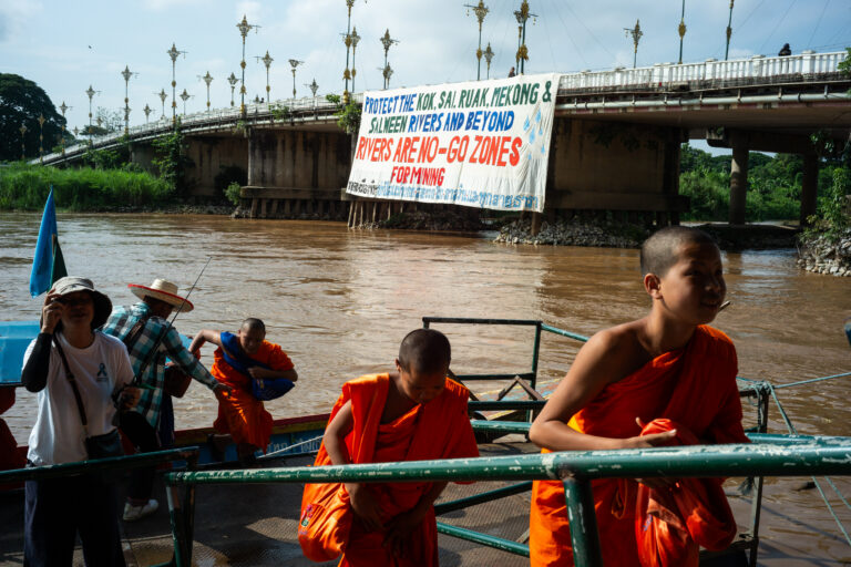
BANGKOK — More than 600 residents of Chiang Mai and Chiang Rai provinces embarked May 31 on a roughly 68-kilometer, six-day ‘peace walk’ to demand the Thai government take action on the river pollution crisis that has seen Thai rivers polluted with heavy metals. The ensemble of affected residents, civil society groups, monks and students marched from Tha Ton subdistrict in Chiang Mai to the city of Chiang Rai in northern Thailand, reaching their destination on June 5, World Environment Day. For more than a year, Thailand’s Pollution Control Department has reported dangerous levels of arsenic, mercury, cadmium and other heavy metals in rivers across northern Thailand, with mining operations across eastern Myanmar suspected to be responsible for the pollution. “We are walking because our rivers are slowly dying,” Pianporn Deetes, executive director of the Rivers and Rights Foundation, which helped to organize the peace walk, told Mongabay by phone. “Toxic contamination from unregulated mining upstream is already affecting water, fish, food, livelihoods, and public health. We do not want to wait until more people become sick. This is an emergency.” Pianporn said the walk (42 miles) was about taking collective action to share information, document impacts and build public pressure in a bid to force the government to address the issue, which Pianporn said has, so far, been lacking. “Monitoring has improved, but action has not matched the scale of the crisis,” she said. “We need urgent diplomatic engagement with neighboring countries, stronger health monitoring, transparency, and action to…This article was originally published on Mongabay

  •  

How did land plants change rivers?

The evolution of land plants about 450 million years ago altered many of Earth’s geologic processes, like weathering and erosion. Due to the lack of evidence for meandering rivers before then, past scientists hypothesized that plants could have caused straight rivers to meander. However, in recent decades, researchers have challenged this idea. They’ve suggested that plants could have changed rivers without causing them to meander.

To understand how vegetation changed rivers in the past, researchers recently studied 49 modern meandering rivers. They sorted these rivers into 3 categories – vegetated, unvegetated, and semi-vegetated – by analyzing color images taken of them from the air. They identified 18 vegetated rivers located in South America, 24 unvegetated rivers in the western United States, and 7 semi-vegetated rivers in China and the Eastern United States. 

To examine the impact of plants on these rivers, the researchers quantified how much each river channel curves, known as its sinuosity. They used opposite banks of each river bend to find its center point, then, using digital maps, drew a line along the river’s trajectory at an equal distance between the bend center points. They used this line to calculate the angle between the river’s curve and the center point. This angle, called the migration angle, shows how a river bend relates to the river’s downstream direction. By measuring it, researchers can tell whether a river is developing more vertically or horizontally, and how sharp its bends are, either of which could be influenced by plants. 

The researchers compared migration angles across each river system to determine how river bends varied between vegetated and unvegetated rivers. They found that vegetated rivers tend to deposit sediments in the river bend, leading to curvier bends that develop horizontally and widen over time. In contrast, unvegetated rivers deposit sediment downstream, which means the rivers bend less and have greater variability in bend width.

The question remained whether plants were the primary cause of these differences or whether other factors were at play. To resolve this, the researchers investigated 3 additional factors. The first was the natural fluctuations in water flow across a river system, called its flow variability. They found that during storms, flow variability caused river bends to move downstream in unvegetated rivers, but not in vegetated rivers. This result suggested that flow variability alone didn’t drive downstream migration, although it can directly impact vegetation. 

The second variable the researchers analyzed was the amount of sediment a river can carry, or its sediment flux. They found that rivers carrying more sediment can erode more banks, also shifting river bends. However, rivers with more sediment but the same level of plant coverage had statistically similar bend angles. Thus, the researchers concluded that sediment flux alone can’t drive bend development, and that the changes were instead dependent on vegetation cover. 

The third variable they analyzed was riverbank strength. The researchers observed rivers with strong banks, made of rock or compacted sediment, and weak banks, made of loose sediment. They observed no difference in river bends with the same vegetation cover but different bank strengths. The researchers concluded that bank strength is also not the primary driver of bend migration in vegetated or unvegetated rivers. 

Of the 4 variables the researchers examined – flow variability, sediment flux, bank strength, and vegetation cover – vegetation cover consistently had the greatest impact on the appearance of meandering rivers. They concluded that meandering rivers could have existed before plants, but would have looked different. Like modern unvegetated rivers, ancient meandering rivers likely had lower-angle bends. As plants evolved and grew on river banks, the bends would have developed differently, becoming curvier like modern vegetated rivers. They suggested that understanding this process provides insight into life on Earth before plants evolved 450 million years ago. 

The post How did land plants change rivers? appeared first on Sciworthy.

  •  
❌