For more than seven decades, phosphorus has represented one of the great paradoxes in the study of the origin of life. This element, indispensable for the existence of living beings as we know them, forms the structural backbone of DNA and RNA, allows cells to store and transfer energy through the molecule adenosine triphosphate (ATP), […]
From the rim of Jezero Crater, Earth is only a bright point in the sky. On July 2, NASA’s Perseverance rover watched that point vanish behind Phobos, Mars’ larger moon, and recorded the event with its Mastcam-Z camera. The sequence is the first time humanity has observed Earth disappearing behind an object from the surface […]
What's in the photo? The lava-stained slopes and ash cone of a highly active volcano
Who took the photo? An unnamed astronaut on board the International Space Station
When was it taken? Oct. 6, 2020
This dramatic astronaut photo shows a highly active stratovolcano in Tanzania that was recently adorned with a striking white "crown" of ash. The explosive volcano produces a rare type of lava that is unusually cool, uniquely colored and the fastest-flowing on Earth.
The volcano is officially named Ol Doinyo Lengai and stands up to 9,718 feet (2,692 meters) above the grassy plains of the Arusha region of northern Tanzania. The local Maasai people call the towering peak the "Mountain of God," because they believe it is the residence of the supreme creator god Ngai (also known as Engai or Enkai), according to the book "Sacred Mountains of the World" (Cambridge University Press, 2022).
Ol Doinyo Lengai is one of Africa's most active volcanoes; it has been erupting on and off for the past 15,000 years. It alternates between effusive eruptions, where lava seeps out of its vents, and sporadic explosive outbursts, which can drastically alter its appearance. Its most recent eruption, which is effusive, has been going on since April 2017, according to the Smithsonian Institution's Global Volcanism Program.
The sacred mountain produces a rare type of lava that consists of natrocarbonatite rock, which is rich in sodium, potassium and calcium carbonate but low in silica. As a result, it is much cooler than most other lava, dipping to temperatures below 1,100 degrees Fahrenheit (600 degrees Celsius). It also has an unusually low viscosity, which makes it "some of the fastest-flowing lava in the world," according to NASA's Earth Observatory.
When it solidifies, this unusually runny lava turns surprisingly pale, due to chemical reactions with rainwater and moisture in the air. In this image, you can see several lightly colored rivers of rock snaking down the volcano's flank. The youngest of these lava flows was created during an eruption in 1998.
For most of the past century, Ol Doinyo Lengai's summit consisted of a bowl-like depression that gradually filled with lava. But between 2007 and 2008, a series of major explosive eruptions birthed a 330-foot-tall (100 m) ash cone that now looms over the summit's center.
This explosive event has transformed the volcano's appearance when viewed from space, additional photos from the Earth Observatory show. In the featured image, a dark spot of fresh lava can be seen in the center of the cone, making it look like a crown.
Lake Natron, near Ol Doinyo Lengai, hosts large flamingo populations. (Image credit: TONY KARUMBA/AFP via Getty Images)
Ol Doinyo Lengai is located in the East African Rift System, a roughly 2,000-mile long (3,500 kilometers) area surrounding a divergent fault line where the African Plate is splitting into the Somali and Nubian plates.
This region has been tectonically active for more than 25 million years and has created some of the continent's most interesting topographic features, including Mount Kilimanjaro and Mount Kenya, which are located on each side of Ol Doinyo Lengai, according to the Earth Observatory.
The godly mountain is around 10 miles (16 km) south of Lake Natron, a red salt lake that's famed for its large flamingo populations. The geographical features are often photographed alongside one another.
A 2020 astronaut photo shows three uniquely colored lakes — Tahoe, Walker and Mono — straddling contrasting biomes on either side of the California-Nevada border.
More than 140 million miles away from Earth, a rare event recently occurred in the twilight skies above Mars, and it was all captured on camera by NASA’s Perseverance rover.
Imagery of a celestial alignment, featuring Earth as it briefly vanished behind the Martian moon Phobos, was revealed in composite photos captured by Perseverance’s Mastcam-Z instrument in early July as the intrepid rover embarked on its 1,907th Martian day, or sol, on the Red Planet.
The rover’s Mastcam-Z camera system, developed by Arizona State University in collaboration with Malin Space Science Systems, was built for capturing high-resolution panoramic zoom imagery of the Martian landscape. Although its main objectives involve its investigations of Jezero Crater and ancient geological features preserved there for eons, which may even include evidence of past microbial life, cases like the recent celestial alignment showcase how the rover’s cameras can also provide unique insights into astronomical events.
A sequence of composite images (after color correction) reveals the irregularly-shaped Martian moon Phobos with Earth, appearing as a tiny point of light, disappearing behind it (Image Credit: NASA/JPL-Caltech/ASU/MSSS/SSI)
A Robot on Mars Captures an Occultation
Captured against fading twilight, our Earthly home appears as little more than a tiny, bright speck of light as it slowly passes behind the irregularly shaped Martian moon, in what astronomers refer to as an occultation.
NASA applied processing to the rare images, which helped to filter out some of the background light, revealing the brief celestial pairing in greater detail. The resulting imagery offers a glimpse of a dark backdrop that now better highlights the motion of Earth and Phobos in their treks through the Martian sky.
A Sunset Unlike Any Other
The image was obtained roughly 40 minutes after the Martian sunset, as the natural orbital path Phobos follows causes it to appear to drift upward in the new sequence of images, while Earth moves diagonally downward, then slips out of view behind the oddly shaped Martian companion.
Imagery with enhanced inset of the Martian moon Phobos with Earth visible behind it (Image Credit: NASA/JPL-Caltech/ASU/MSSS/SSI)
In an annotated version released by NASA, timestamps spanning just 40 seconds illustrate the progression of the event in single frames, offering a look at a sunset unlike any ever seen on Earth.
That isn’t to say that the same effect can’t be seen from our planet, but in reverse: a lunar occultation where Mars passes behind the Moon can also be observed here, under the right conditions.
Occultations are frequently used by astronomers to help study the positions and motions of various celestial bodies in this way. However, seeing one from the surface of another planet is a rare treat, offering a view of Earth as a distant point of light.
In the past, Perseverance has also captured images of a lunar eclipse from its position on the Martian surface, as Phobos was seen passing in front of the Sun. Past imagery collected by NASA’s robotic explorer has also documented appearances of the Martian moon Deimos in the Red Planet’s early morning skies.
Colors of Change on a Red Planet
Although Mars’ characteristic rusty hues are ever-present, the recent imagery also offers a glimpse of other subtle colors seen in the Martian environment, particularly at twilight. With subtle bluish grays that gradually transition to redder tones, the new images offer a more nuanced and colorful look at the Red Planet.
Close up of the original composite images before color adjustments, where Phobos can be faintly seen against the Martian twilight, with Earth appearing as a speck of light behind it (Image Credit: NASA/JPL-Caltech/ASU/MSSS/SSI).
Perseverance has now spent more than five years exploring Mars, and its ongoing discoveries have added a wealth of new information to the growing body of knowledge scientists have collected about our nearby planetary neighbor.
As for the recent imagery the rover captured, such a unique view requires careful timing, along with a bit of good fortune, according to Mark Lemmon, a Mastcam-Z co-investigator at the Space Science Institute in Boulder, Colorado.
“Phobos crosses the Martian sky three times a day, and Earth is visible for months at a stretch,” Lemmon said in a statement, adding that “catching one directly behind the other takes planning and a little luck.”
Additional details provided by NASA about the new imagery can be found here and here.
Micah Hanks is the Editor-in-Chief and Co-Founder of The Debrief. A longtime reporter on science, defense, and technology with a focus on space and astronomy, he can be reached atmicah@thedebrief.org. Follow him on X @MicahHanks, and at micahhanks.com.
The economist John Maynard Keynes once remarked, “In the long run we are all dead.” From an astronomical standpoint, this is true for the Earth itself. In roughly 5 billion years, the Sun will exhaust the hydrogen at its core and enter the next phase of its life as a Red Giant, where it will swell up large enough to engulf and destroy the Earth.
Currently, the Sun is still in its main-sequence phase, where it fuses hydrogen into helium in its core. Although it remains relatively stable during this phase, it will gradually grow brighter with time. As the Sun shines brighter, the increased heat and radiation will raise Earth’s surface temperature, potentially pushing it past the threshold for life to survive.
One of Earth’s geological processes that helps regulate its surface temperature is the carbon cycle. Over millions of years, carbon moves from the Earth’s interior into the atmosphere as carbon dioxide or CO2, where it functions as a greenhouse gas that traps heat. Plants take in this CO2 through photosynthesis and move carbon through the biosphere.
Meanwhile, rain and rock weathering draw carbon into the oceans and rocks. By pulling CO2 out of the atmosphere, the carbon cycle could mitigate Earth’s warming as the Sun brightens over time. Today, human activities are increasing atmospheric CO2 and warming the planet. However, over billions of years, the carbon cycle could gradually remove enough CO2 from the atmosphere that eventually too little would remain to support photosynthesis.
With these challenges to life on Earth in mind, the researchers Jacob Haqq‐Misra and Eric Wolf investigated how long Earth’s biosphere could last in the distant future. The team used computer models to calculate the balance of energy that Earth would receive and emit over time, accounting for the effects of increasing sunlight and changing atmospheric CO2 concentrations. They followed this up with calculations using the ExoCAM model to determine the temperature and atmospheric conditions of future Earth across different latitudes. They related these conditions to a habitability metric to determine their impact on the biosphere.
To estimate the biosphere’s maximum possible lifespan, the team conducted 29 simulations representing the planet’s conditions over the next 2 billion years. In one set of simulations, the Earth’s carbon cycle contributed little to regulating surface temperature, with the atmosphere’s CO2 concentration fixed at approximately modern levels of 400 parts per million (ppm) and surface temperatures continuing to increase. In another, the carbon cycle worked to keep Earth’s average surface temperature fixed at the modern average of approximately 59℉ (15℃), no matter how much it had to reduce CO2 in the atmosphere.
In the scenario with a fixed CO2 concentration, the team found that in 1.7 billion years, Earth’s surface reached an average of 122°F (50°C), which is too hot for most land plants. After 1.9 billion years, it reached 149°F (65°), becoming too hot for all land plants to survive as temperatures continued to rise.
They also found that in the fixed average surface temperature scenario, atmospheric CO2 dropped below the 150 ppm level that most plants require for photosynthesis within 500 million years. After 1.4 billion years, CO2 levels fell below 10 ppm, leaving only a few land photosynthesizers and aquatic plants alive. After about 1.8 billion years, atmospheric CO2 dropped to 1 ppm, leaving only microbes capable of photosynthesis.
The researchers’ findings generally extend the estimated lifetime of Earth’s future biosphere compared with earlier, simpler models that suggested maximum lifespans of 100 million to 1.5 billion years. However, they clarified that other scientists should verify their results by running tests with other models, especially under extreme conditions of high incoming solar radiation and low atmospheric CO2.
Lastly, Haqq‐Misra and Wolf noted that their model did not account for major evolutionary changes that could help life adapt to future conditions. Over time, plants could evolve to tolerate higher temperatures or lower atmospheric CO2 levels. Future humans or another intelligent species might also engage in large-scale geoengineering projects to prevent the end of life on Earth. If life on Earth proves adaptable enough, the biosphere may endure until a Red Giant fills the daytime sky.
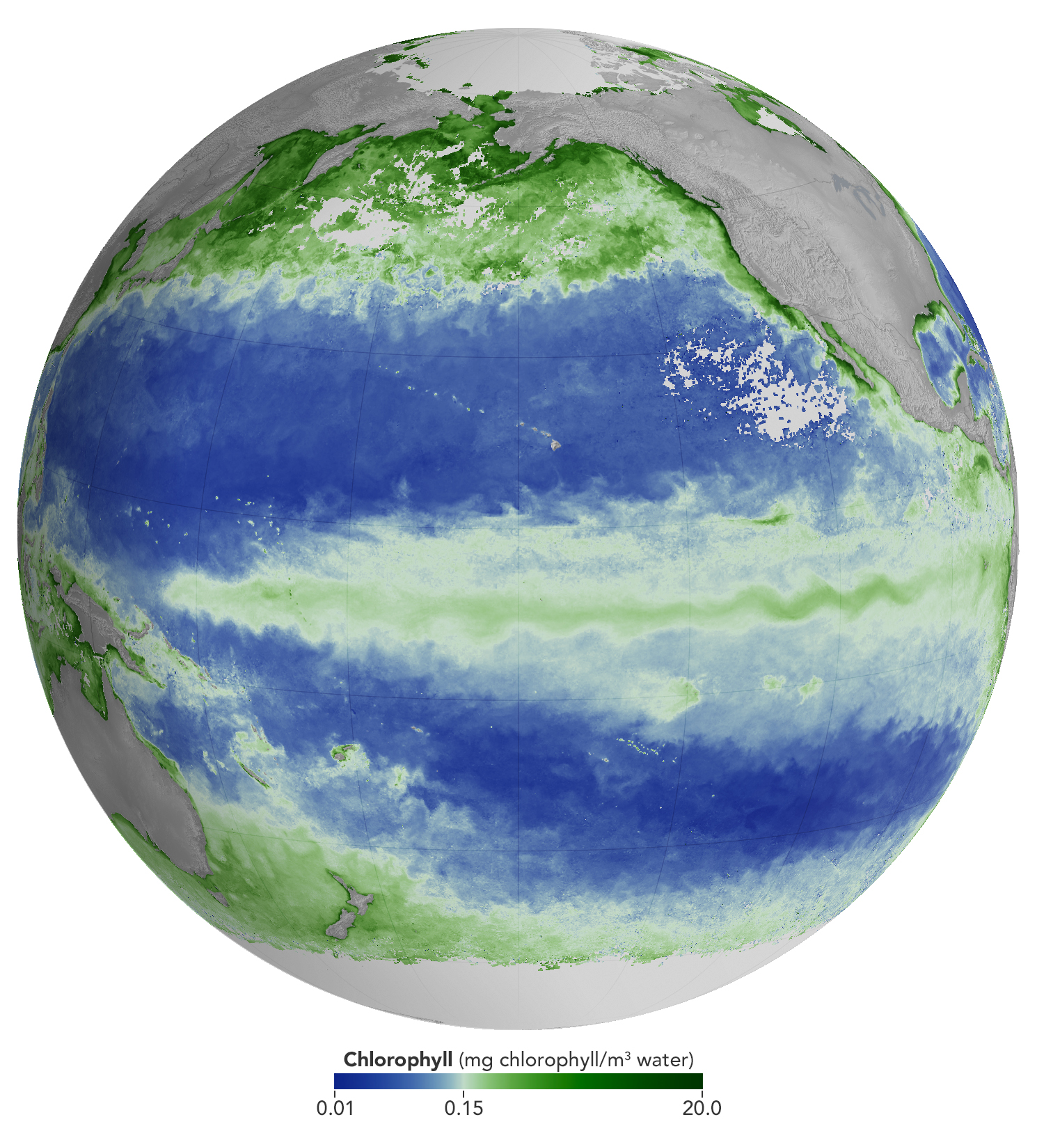
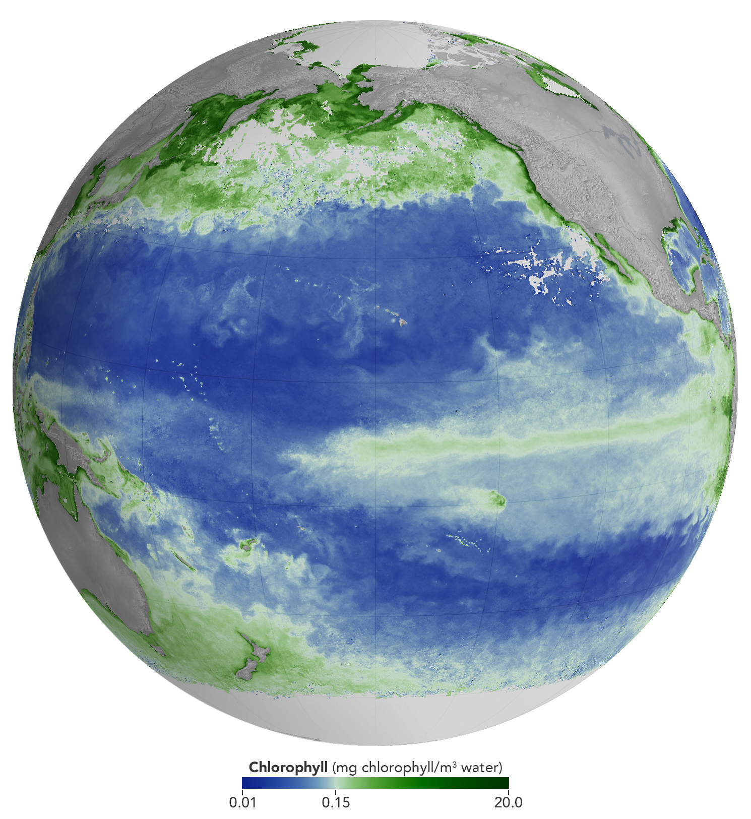
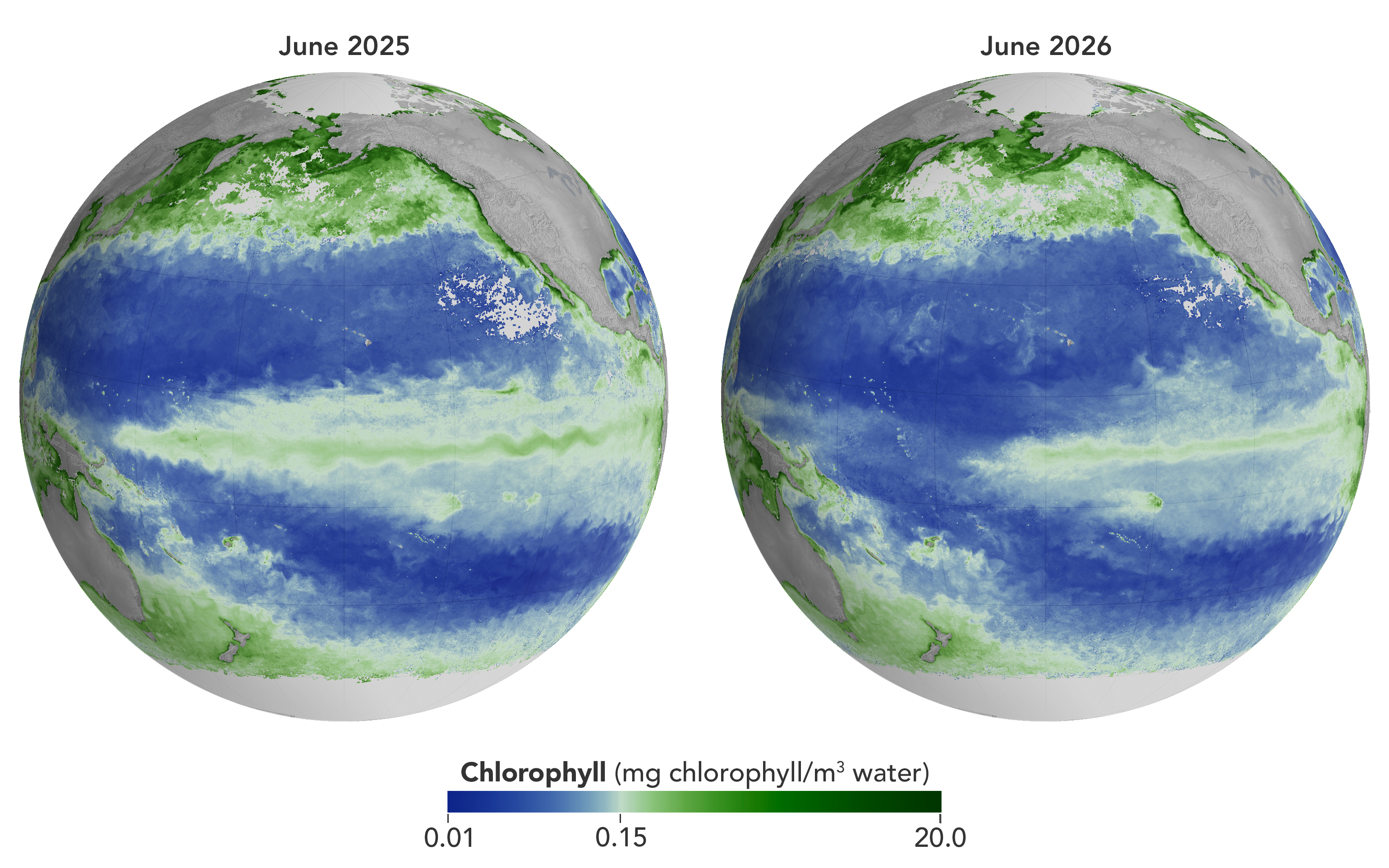
Concentrations of chlorophyll in the equatorial Pacific deviate from normal during El Niño events. These maps depict monthly average chlorophyll concentrations for June 2025 (left), under neutral conditions, and June 2026 (right), as El Niño was strengthening. Data come from the OCI (Ocean Color Instrument) on NASA’s PACE (Plankton, Aerosol, Cloud, ocean Ecosystem) satellite and are based on measurements of green and blue light from the ocean reflected back to the sensor. NASA Earth Observatory images by Michala Garrison.
As of June 2026, El Niño has officially arrived. This naturally recurring phenomenon is characterized by warmer-than-normal water temperatures in parts of the equatorial Pacific along with changes to atmospheric and oceanic circulation patterns. Its regional effects range from desert floods to delayed monsoons to shifts in where tropical cyclones are more likely to form.
NOAA’s Climate Prediction Center expects the current El Niño to continue to strengthen through the end of 2026, with a 97 percent chance of lasting through early Northern Hemisphere spring 2027. Even during El Niño’s early stages, satellites have observed characteristic changes along the equatorial Pacific, such as warmer-than-normal sea surface temperatures and higher-than-normal sea surface height.
Among the first ecological downstream effects are changes to the marine food web. The maps above show chlorophyll-a concentrations—the pigment present in most phytoplankton—as observed by the OCI (Ocean Color Instrument) on NASA’s PACE (Plankton, Aerosol, Cloud, ocean Ecosystem) satellite. In June 2025 (left), conditions were neutral, while in June 2026 (right), El Niño was strengthening.
The most noticeable difference appears in the central Pacific, around the equator due north of New Zealand: chlorophyll concentrations, an indication of phytoplankton abundance, are substantially lower in 2026. This change is expected, said Matthew Kehrli and Graham Trolley, oceanographers in the Ocean Ecology Laboratory at NASA’s Goddard Space Flight Center. That’s because during an El Niño, easterly equatorial trade winds weaken, the warm surface layer of the ocean extends deeper, and the upwelling of cool, nutrient-rich water that typically fuels phytoplankton growth is suppressed.
As the El Niño progresses, the scientists anticipate the differences in the central Pacific will become more pronounced. “This may manifest as a greater difference in values across the current region, as a broadening region of reduced surface chlorophyll-a concentration, or both, depending on the behavior of the equatorial trade winds,” they said.
Reductions in phytoplankton have ripple effects through the marine food web, including in coastal regions. Less food is available for zooplankton, as well as for fish, seabirds, and marine mammals. Peru’s anchovy fisheries have seen profound declines in catch during past El Niños, driven similarly by warmer surface waters, reduced upwelling, and lower phytoplankton abundance. In 2026, Peru’s Ministry of Production repeatedly suspended the fishery to safeguard the country’s main fishing resource. Pelicans have been seen venturing into Peruvian ports and urban areas in search of food.
Although the disruptions to marine life can be severe, a post-El Niño “chlorophyll rebound,” with higher-than-normal concentrations in the equatorial Pacific, can occur. Research suggests that higher iron concentrations delivered in ocean currents, as well as dust arriving from drier land in parts of Central and South America, help fuel the resurgence—a rebound that doesn’t require a follow-on La Niña. La Niña, which often follows El Niño events, can also produce elevated chlorophyll concentrations. A strong La Niña in 1998–1999 set off a large phytoplankton bloom in the eastern Pacific and a dramatic increase in fish populations.
Scientists have new tools available for studying this sort of variability. The PACE mission launched in February 2024, making this the first complete El Niño event for which the satellite will gather global, near-daily hyperspectral measurements. “The scientific community will be able to observe the 2026 El Niño with data across more wavelengths of light than ever before,” Kehrli and Trolley said.
To better understand effects on life in the ocean, researchers hope to use PACE data to gauge the responses of specific phytoplankton communities to El Niño. And the possibilities extend beyond the marine realm, the scientists note. PACE’s sensors can measure plant pigment composition on land and clouds and aerosols in the atmosphere, all of which are influenced by El Niño.
Satellites designed to provide internet service are now serving an unexpected second purpose: helping scientists map the nearly invisible atmosphere at the edge of space. Researchers at Kyoto University have used orbital changes from about 1,200 Starlink satellites to map Earth’s thermosphere, a thin and difficult-to-observe region of the upper atmosphere. Their analysis produced the [...]
Near-extinct oryx are returning. Farms are prospering as irrigation water reaches fields for the first time in decades. Farmers are even nurturing new trees on their land.Once a byword for drought and famine, the African Sahel region on the southern flank of the Sahara Desert now has more water than it has for decades. Wells are filling as water tables have risen by 13 feet or more in places. Lake Chad, which was one of Africa's largest expanses of water before shriveling during the droughts, is recovering.
Over years of drought in the late 20th century, the sun hard baked the soils of the Sahel. Now, erratic but extreme rains are returning to this semi-arid region, causing lethal floods but also replenishing rivers, filling desert depressions, restoring water to dried riverbeds known as wadis, and sluicing rainwater off impermeable soils directly into aquifers. The process began in the 1990s but has accelerated in the past five years.
"Across the Sahel, from Ethiopia to Senegal, we have evidence of increased terrestrial water storage," says Richard Taylor, a hydrogeologist at University College London who has led ground teams investigating the relationships between climate, land use, and groundwater recharge in the region.
But increased rainfall since the drought years of the 1970s and 1980s explains only some of the rewetting of the Sahel. It cannot fully account for the transformation, say researchers. Also driving the rewetting, they posit, are changes to the land surface, ranging from the internationally funded Great Green Wall project to the revival of traditional water harvesting methods and the chaos caused by jihadist militants, which has led to the abandonment of irrigation projects that once emptied rivers of their flows.
Much remains unclear in these remote lands on the edge of the Sahara Desert, but the trend seems set to be long-term, with climate scientists saying more — and more extreme — rainfall is on the way in the 21st century. As underground water reserves revive, some are forecasting an agricultural renaissance.
The Sahel is a band of semi-arid land around 500 miles wide that stretches across North Africa, from Senegal in the west to Ethiopia in the east, with a fast-growing population above 150 million. It is a transition zone between the Sahara Desert in the north and savanna grasslands and coastal forests to the south. Water is everything in the Sahel. Its rains are critical to human survival, but they have been sporadic and unpredictable since the close of a humid era around 5,000 years ago.
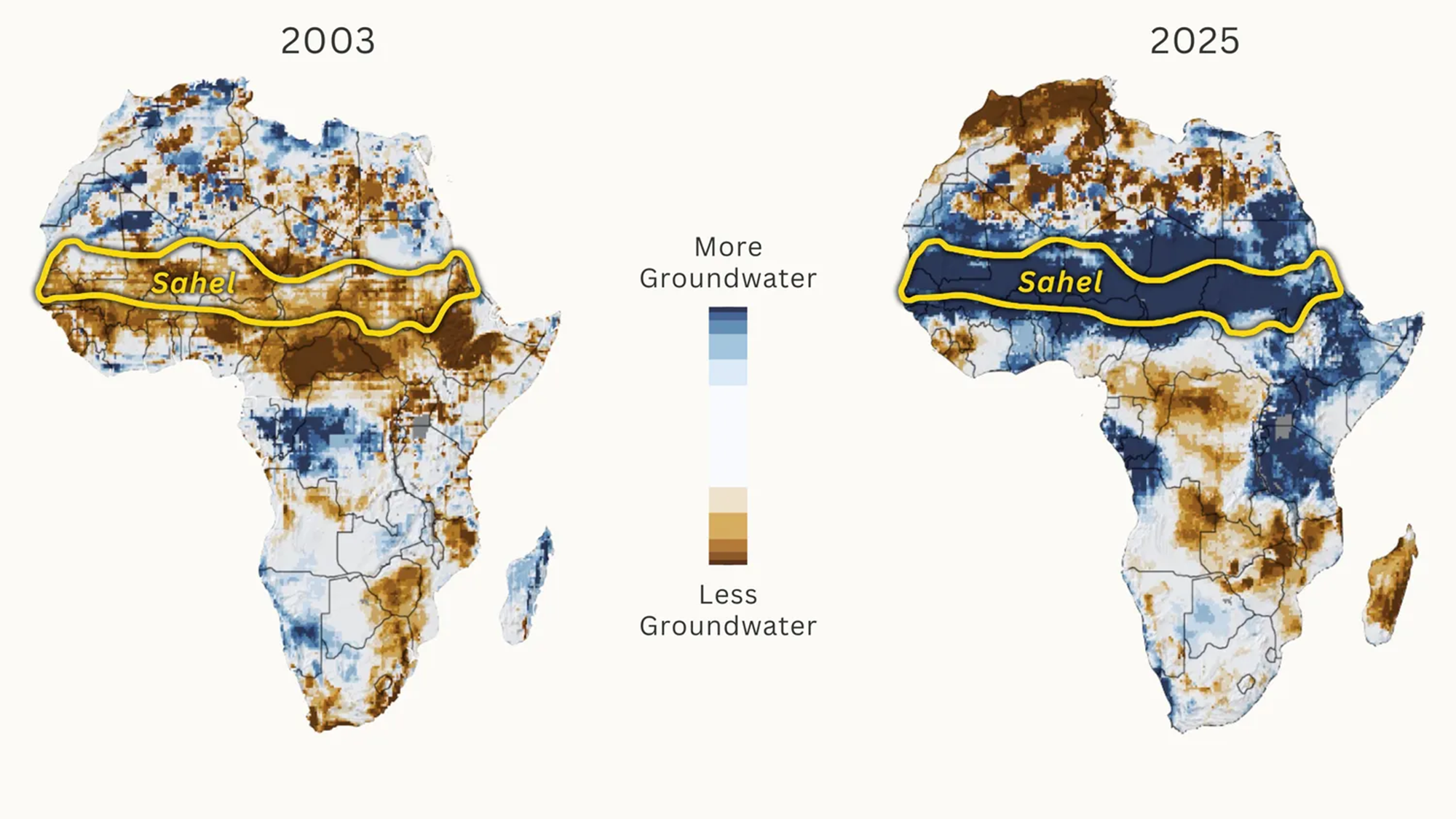
Shallow groundwater storage in February 2003 and February 2025, as compared to the average from 1948 to 2012. (Image credit: NASA / Adapted by Yale Environment 360)
How much rain the Sahel gets depends on the West African monsoon, a wet wind that sweeps north from the Gulf of Guinea between June and September, and on how far the monsoon penetrates into the interior. Whether it reaches the 15th parallel north of the equator or stalls at the 10th parallel make the difference between a good year and a failed harvest, say hydrologists.
During the droughts of the late 20th century, as the monsoon repeatedly fell short, up to a million people died of hunger and disease. But now, with a strengthening monsoon, there is talk among scientists of the Sahel being on the verge of a new humid era.
That is good news for wildlife. With wadi systems reviving in Chad's Ouadi Rimé-Ouadi Achim nature reserve, conservationists are documenting resurgent numbers of aardvarks, porcupines, badgers, and foxes, and the successful reintroduction of the scimitar-horned oryx, which was once declared extinct in the wild but now numbers more than 600 individuals. Elsewhere, West African giraffes are browsing on verdant vegetation in areas from which they had disappeared.
As the rains return, farmers have boosted crop yields by nurturing the natural regrowth of some 200 million trees on formerly treeless fields in southern Niger, according to former World Resources Institute geographer Chris Reij. And, supported by new aid programs such as the World Bank's regional recovery program PROLAC, they are re-establishing small-scale irrigation systems by tapping groundwater around resurgent oases in Chad, Niger, and Cameroon.
"In the past … there was not enough water to irrigate crops, and our harvests were meager. Now our lives have changed," Achta, a farmer in Chad, said last year. She now has water to plant on four times as much land and has doubled her onion crop. The Bank says her story "reflects a broader transformation across the Lake Chad basin."
Most places in the Sahel are seeing more rainfall. And that rain has become concentrated in extreme downpours from clusters of violent thunderstorms, known to meteorologists as Mesoscale Convective Systems, that occasionally bubble up during the monsoon season. Sahelian storm clusters are now rated as some of the most powerful on the planet, and they deliver most of the region's rainfall. There has been a threefold increase in the frequency of extreme storms since the 1980s, according to a recent analysis.
Why the revival of the rains? An assessment published in 2021 by the U.N.'s Intergovernmental Panel on Climate Change found "high confidence" among climate scientists that it is a result of strong warming in the North Atlantic, caused by a combination of global heating and a reduction, in Europe and North America, of sulphate aerosols from coal burning, which once created a thin haze that cooled the ocean. That cooling prevented the northward migration of the West African monsoon into the Sahel, resulting in drought. But the clean-up has warmed the ocean and pulled the monsoon back into the Sahel, strengthening its ability to produce deluges.
The streets of the Keurs Massar area in Dakar are flooded on Sept. 7, 2020 after a monsoon in Senegal. (Image credit: SEYLLOU via Getty Images)
The effects of these mega-storms are especially challenging in a region more used to disasters caused by the absence of rain. Niger, one of the world’s 10 poorest countries, saw tens of thousands die from famine during the late 20th century droughts. Now, it sees more deaths from floods than droughts. Fierce storms during the 2024 monsoon season inundated the capital, Niamey, and in rural areas washed away more than 150,000 mud-brick homes.
Sudden downpours are initially destructive, but they are a boon to underground water reserves. Falling onto compacted ground, the water does not initially infiltrate the soil but rushes into rivers and dry wadis, which speed the water's flow into aquifers.
Hydrologists say that this indirect infiltration is most intense after heavy storms. "In some locations, rainfall intensity is more important than the annual rainfall amount in determining the magnitude of groundwater recharge," says Taylor. This intensity, he says, is a major cause of the rapid rising of water tables — especially since, in the Sahel, most water drains not to the ocean but inland to depressions and lakes.
Not only are new ponds forming across the formerly arid lands; ancient networks of wadis are being restored. And Taylor's network of researchers has found wells across the region refilling. Mean water tables in much of Niger have risen by some 13 feet, indicating a 15 percent increase in aquifer reserves.
This local data is now being corroborated by analysis from satellites that measure changes in land mass by tracking subtle changes in gravitational force from the land below. NASA's Gravity Recovery and Climate Experiment mission has found a sharp increase in gravitational force across the Sahel in the past two decades that hydrologists attribute to growing terrestrial water storage.
But rainfall and its intensity are only part of the story. Events on land also play a part.
Environmentalists have long held that the encroachment of agriculture into the Sahel during the 20th century caused "desertification" by removing natural vegetation, destroying soils, and allowing the advance of desert sands. But hydrologically, the effect may be the opposite because some crops can actually help the land retain water.
All vegetation absorbs moisture from the soil before transpiring it into the air. But shallow-rooted African grain crops such as millet and sorghum transpire less moisture than the deeper-rooted grasses they replace, leaving more moisture in the soil.
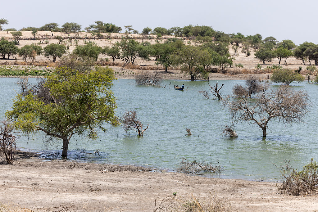
Dead trees in an arm of Lake Chad near Kiskawa, Chad, that was recently flooded. (Image credit: JORIS BOLOMEY via Getty Images)
An amplifying factor is the drought-driven crusting of soils, which has increased runoff by around 50 percent in the central Sahel in recent decades. Analysis by Christophe Peugeot, a hydrologist at the HydroSciences laboratory at the University of Montpellier in France, found that the droughts "have permanently transformed the region's soils… fueling today's floods."
Much of this runoff ends up in Lake Chad, on the border between Nigeria, Cameroon, Chad, and Niger, which drains an area almost six times the size of California. The lake's dramatic demise became a totemic image of the late 20th century hydrological decline of the Sahel. But less well known is that the lake is now recovering, as water inflows increase. Hydrogeologists at the University of N'Djamena in Chad report that in 2024 it swelled to a peak of more than 9,000 square miles, almost as big as in the 1960s and 10 times its size in the mid-1980s.
This growth is partly masked by large areas of saturated vegetation in the lake that do not show up in satellite images, say hydrologists. But as the lake grows, the aquifer beneath is also refilling.
Some researchers argue that deliberate efforts to capture rain in soils can also help explain the rising groundwaters across the region. One such effort is the Great Green Wall. Originally planned as a barrier of planted trees to prevent the advance of the Sahara, it has morphed into more grassroots efforts to control soil erosion by capturing rainfall and improving soil moisture, all of which can improve infiltration underground.
Many such projects revive traditional water-harvesting techniques, including the placement of stones along hill contours, digging small holes known as "zai pits" amid crops, and forming crescent-shaped mounds around trees.
Alpha Lo of the Climate Water Project, who highlighted the restored Sahelian groundwaters in a recent online analysis, argues that such techniques are "the primary reason." But most researchers believe that, while locally effective in nurturing trees or crops, they are not happening at sufficient scale to explain the region-wide resurgence.
A final suggestion is that humans are extracting less water from rivers, leaving more to eventually infiltrate into aquifers. One driver of this trend is the decline of big irrigation projects that were constructed during the drought years to boost food production. For instance, Cameroon once largely emptied the River Logone, historically the biggest single source of water flowing into Lake Chad, to grow rice. But the SEMRY irrigation project reportedly diverts much less water now, due to poor management, aging infrastructure, and the outmigration of farmers.
In areas around Lake Chad, farmers have also abandoned their irrigated fields because of Boko Haram, a militant jihadist group that continues to terrorize communities. Timmo Gaasbeek, food security policy officer at the Netherlands Ministry of Foreign Affairs, says the chaos in northern Nigeria "means that the water in the rivers is not caught upstream, and continues to flow into Lake Chad, where it contributes to higher water levels and more groundwater recharge."
Most climate models predict a further increase in annual rainfall in the coming decades, due to global heating and the banishing of cooling aerosols from the North Atlantic. Taylor predicts that "the Sahel will experience particularly marked increases in extreme rain" that will "serve to increase groundwater recharge."
Peugeot says that "the increased availability of water in valley bottoms could promote the development of irrigation, offering new prospects in several Sahelian regions." Buoyed by such predictions, Nigeria is looking to restore the 165,000-acre South Chad Irrigation Project on the former shores of Lake Chad, which has long been abandoned for want of water.
But the road ahead will not be straightforward. Sahel rains will continue to be erratic on all timescales. Most immediately, climatologists are predicting that this year's strong El Niño event could deliver drought in the eastern Sahel, but bumper rains and more floods further west.

 Login