❌

Normal view

Low Water at San Carlos Reservoir

17 June 2026 at 05:01
June 7, 2023
May 22, 2026
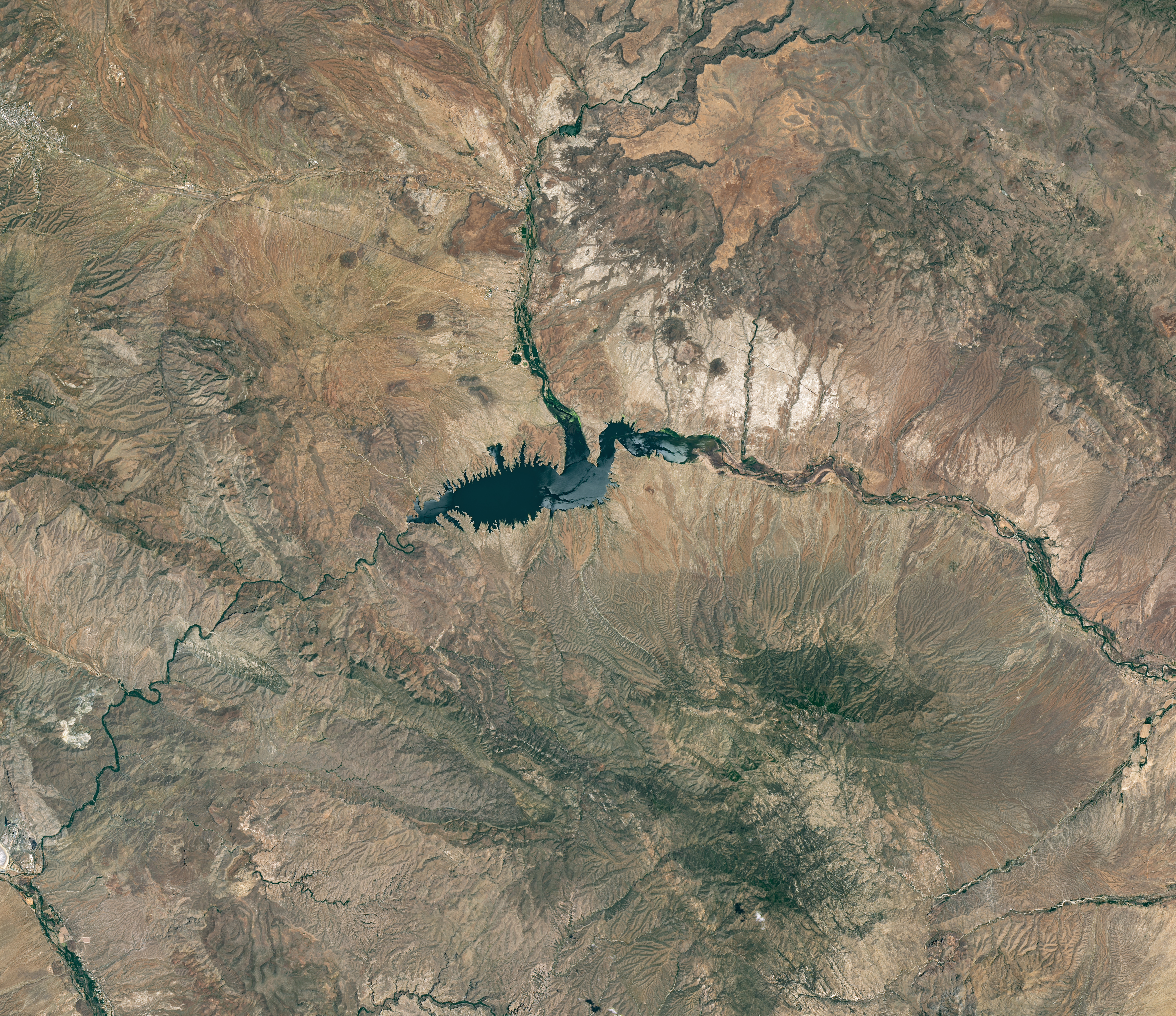
The reservoir appears lake-like and expansive in an image acquired in June 2023.
NASA Earth Observatory/Michala Garrison
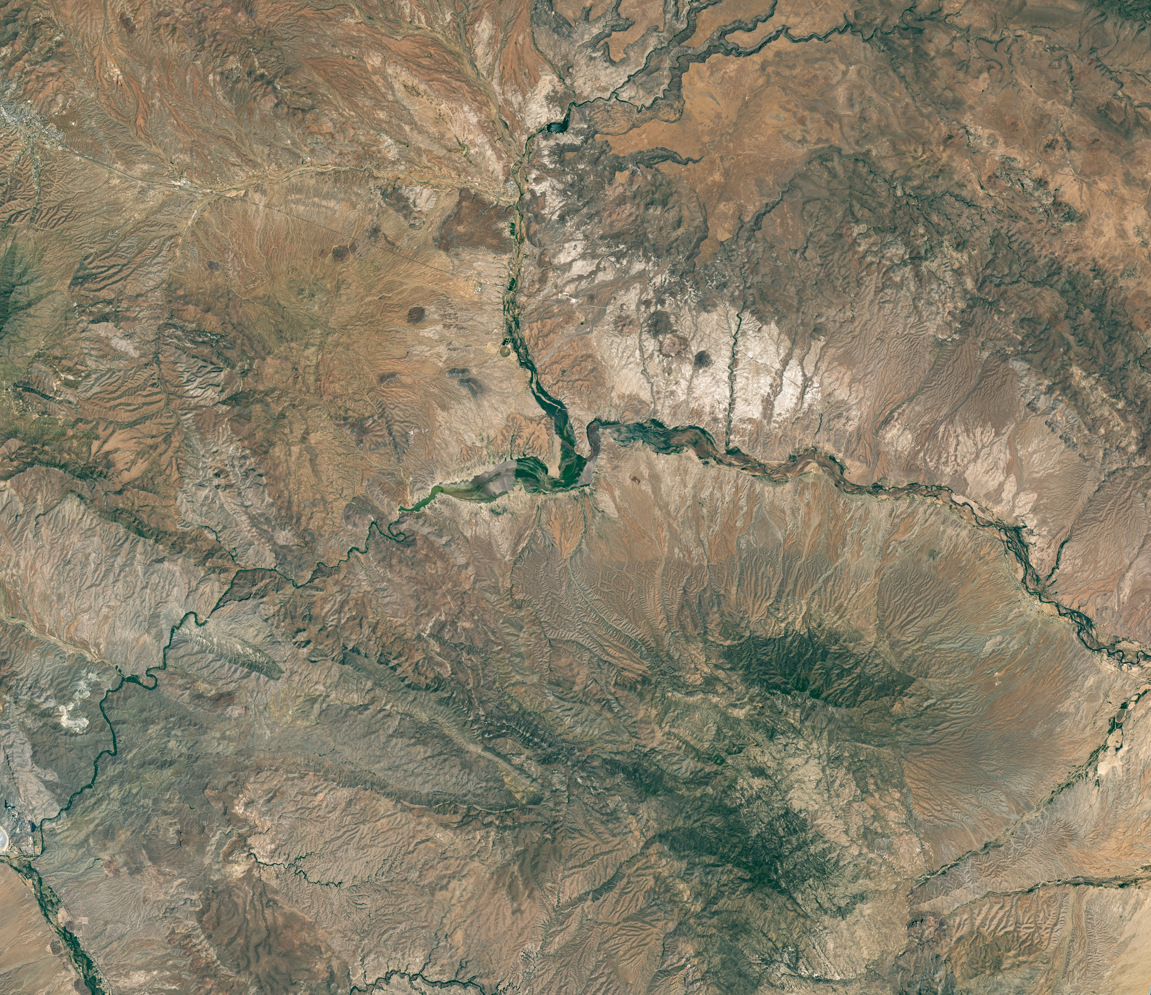
The reservoir is nearly empty by May 2026. The Gila River's natural channel is now visible and flanked with green vegetation in what had been the bottom of the reservoir.
The reservoir is nearly empty by May 2026. The Gila River’s natural channel is now visible and flanked with green vegetation in what had been the bottom of the reservoir.
NASA Earth Observatory/Michala Garrison
June 7, 2023
May 22, 2026
Little water remains in the San Carlos Reservoir in May 2026 (right) compared to fuller conditions in June 2023 (left). Images were captured by the OLI (Operational Land Imager) on the Landsat 9 and 8 satellites, respectively. NASA Earth Observatory images by Michala Garrison.

The Gila River is among the Southwest’s most important rivers, delivering water for people, farms, and wildlife while linking the snow-fed mountains of southwestern New Mexico to the desert lowlands of southwestern Arizona.

In wetter years, seasonal snowfall on the Mogollon Mountains and Black Range provides much of the river’s spring flow and helps refill San Carlos Reservoir, which is formed by the Coolidge Dam. When filled to capacity, the reservoir is one of Arizona’s largest bodies of water.

However, in 2026, lackluster snowfall left the mountain snowpack in the Gila River watershed at 2 percent of the 1991-2020 March median. The limited snowpack pushed April streamflow to 39 percent of normal. By June, after mandatory water releases for downstream agriculture, the reservoir held less than 400 acre-feet of water.

The Landsat image above (right) shows the near-empty reservoir on May 22, 2026, when it stored 389 acre-feet of water—less than 1 percent full; the other image (left) shows the same area in June 2023, when it was about 60 percent full. The green vegetation growing along the river channel and reservoir edge includes a mixture of tamarisk, willow, cottonwood, sedges, and grasses.

Officials closed the reservoir indefinitely on June 5, 2026, after the declining water levels contributed to low oxygen levels—hypoxia—that killed virtually all of its fish. Species living in the reservoir included largemouth bass, black crappie, bluegill, channel catfish, flathead catfish, and several stocked species, including brown trout and rainbow trout. The decomposing fish may pose health risks to people attempting to boat or fish, the San Carlos Recreation and Wildlife Department warned.

The reservoir has hit similarly low water levels in the past, running out of water at least 20 times since it was filled in 1930, according to news reports. Even when the dam and reservoir were first dedicated, there was enough grass growing on the dried reservoir bottom that humorist Will Rogers famously quipped to President Calvin Coolidge: “If that was my lake, I’d mow it.”

Other years with major fish kills include 1976 and 2018. After more than 5 million fish died during a similar event in 1976, the Gila Herald reported that it took five years for the lake’s ecosystem to rebound.

The region is currently in the midst of a multi-year dry period that has left much of the Gila River’s headwaters in New Mexico in a state of severe drought, according to data from the U.S. Drought Monitor.

However, the river’s flow is highly variable, and heavy rains during the coming wet season could help the reservoir recover. A seasonal monsoon outlook released by NOAA in May 2026 projected a 33 to 50 percent chance that an above-average amount of rain would fall in the region that summer. El Niño in the central and eastern equatorial Pacific, which was strengthening in late spring 2026, can make heavy rains in the U.S. Southwest more likely.

NASA Earth Observatory images by Michala Garrison, using Landsat data from the U.S. Geological Survey. Story by Adam Voiland.

Downloads

The reservoir appears lake-like and expansive in an image acquired in June 2023.

June 7, 2023

JPEG (16.60 MB)

The reservoir is nearly empty by May 2026. The Gila River's natural channel is now visible and flanked with green vegetation in what had been the bottom of the reservoir.

May 22, 2026

JPEG (16.85 MB)

References & Resources

You may also be interested in:

Stay up-to-date with the latest content from NASA as we explore the universe and discover more about our home planet.

Drought Parches Florida
4 min read

The state was unusually dry for much of 2025, but the intensity of the drought has ratcheted up since January…

Article
Snow Is Scarce in the Upper Colorado Basin
5 min read

The mountains of Utah and Colorado are among the areas of the western U.S. that are low on snow and…

Article
Spring Rains Saturate Michigan
3 min read

Above-normal precipitation has swollen rivers and damaged infrastructure statewide.

Article

The post Low Water at San Carlos Reservoir appeared first on NASA Science.

Low Water at San Carlos Reservoir

17 June 2026 at 05:01


June 7, 2023
May 22, 2026

The reservoir appears lake-like and expansive in an image acquired in June 2023.
NASA Earth Observatory/Michala Garrison

The reservoir is nearly empty by May 2026. The Gila River's natural channel is now visible and flanked with green vegetation in what had been the bottom of the reservoir.
The reservoir is nearly empty by May 2026. The Gila River’s natural channel is now visible and flanked with green vegetation in what had been the bottom of the reservoir.
NASA Earth Observatory/Michala Garrison

The reservoir appears lake-like and expansive in an image acquired in June 2023.
NASA Earth Observatory/Michala Garrison
The reservoir is nearly empty by May 2026. The Gila River's natural channel is now visible and flanked with green vegetation in what had been the bottom of the reservoir.
The reservoir is nearly empty by May 2026. The Gila River’s natural channel is now visible and flanked with green vegetation in what had been the bottom of the reservoir.
NASA Earth Observatory/Michala Garrison

June 7, 2023

May 22, 2026


Little water remains in the San Carlos Reservoir in May 2026 (right) compared to fuller conditions in June 2023 (left). Images were captured by the OLI (Operational Land Imager) on the Landsat 9 and 8 satellites, respectively. NASA Earth Observatory images by Michala Garrison.

The Gila River is among the Southwest’s most important rivers, delivering water for people, farms, and wildlife while linking the snow-fed mountains of southwestern New Mexico to the desert lowlands of southwestern Arizona.

In wetter years, seasonal snowfall on the Mogollon Mountains and Black Range provides much of the river’s spring flow and helps refill San Carlos Reservoir, which is formed by the Coolidge Dam. When filled to capacity, the reservoir is one of Arizona’s largest bodies of water.

However, in 2026, lackluster snowfall left the mountain snowpack in the Gila River watershed at 2 percent of the 1991-2020 March median. The limited snowpack pushed April streamflow to 39 percent of normal. By June, after mandatory water releases for downstream agriculture, the reservoir held less than 400 acre-feet of water.

The Landsat image above (right) shows the near-empty reservoir on May 22, 2026, when it stored 389 acre-feet of water—less than 1 percent full; the other image (left) shows the same area in June 2023, when it was about 60 percent full. The green vegetation growing along the river channel and reservoir edge includes a mixture of tamarisk, willow, cottonwood, sedges, and grasses.

Officials closed the reservoir indefinitely on June 5, 2026, after the declining water levels contributed to low oxygen levels—hypoxia—that killed virtually all of its fish. Species living in the reservoir included largemouth bass, black crappie, bluegill, channel catfish, flathead catfish, and several stocked species, including brown trout and rainbow trout. The decomposing fish may pose health risks to people attempting to boat or fish, the San Carlos Recreation and Wildlife Department warned.

The reservoir has hit similarly low water levels in the past, running out of water at least 20 times since it was filled in 1930, according to news reports. Even when the dam and reservoir were first dedicated, there was enough grass growing on the dried reservoir bottom that humorist Will Rogers famously quipped to President Calvin Coolidge: “If that was my lake, I’d mow it.”

Other years with major fish kills include 1976 and 2018. After more than 5 million fish died during a similar event in 1976, the Gila Herald reported that it took five years for the lake’s ecosystem to rebound.

The region is currently in the midst of a multi-year dry period that has left much of the Gila River’s headwaters in New Mexico in a state of severe drought, according to data from the U.S. Drought Monitor.

However, the river’s flow is highly variable, and heavy rains during the coming wet season could help the reservoir recover. A seasonal monsoon outlook released by NOAA in May 2026 projected a 33 to 50 percent chance that an above-average amount of rain would fall in the region that summer. El Niño in the central and eastern equatorial Pacific, which was strengthening in late spring 2026, can make heavy rains in the U.S. Southwest more likely.

NASA Earth Observatory images by Michala Garrison, using Landsat data from the U.S. Geological Survey. Story by Adam Voiland.

Downloads

The reservoir appears lake-like and expansive in an image acquired in June 2023.

June 7, 2023

JPEG (16.60 MB)

The reservoir is nearly empty by May 2026. The Gila River's natural channel is now visible and flanked with green vegetation in what had been the bottom of the reservoir.

May 22, 2026

JPEG (16.85 MB)

References & Resources

You may also be interested in:

Stay up-to-date with the latest content from NASA as we explore the universe and discover more about our home planet.

Drought Parches Florida

4 min read

The state was unusually dry for much of 2025, but the intensity of the drought has ratcheted up since January…

Article

Snow Is Scarce in the Upper Colorado Basin

5 min read

The mountains of Utah and Colorado are among the areas of the western U.S. that are low on snow and…

Article

Spring Rains Saturate Michigan

3 min read

Above-normal precipitation has swollen rivers and damaged infrastructure statewide.

Article

New Tungsten-Silicone Contact Lens Technology Restores Vision for Underwater Drone Operators

17 June 2026 at 04:30

Beneath the crushing depths of the ocean, autonomous underwater vehicles (AUVs) are our eyes and ears, tirelessly exploring, mapping, and surveying the mysterious realm beneath the waves. Yet, despite their advanced capabilities, these drones face an age-old paradox: the very domes designed to protect their sensitive sonar systems simultaneously distort the sound waves essential for their operation. This distortion, caused by the curved, hydrodynamic enclosures, acts like a warped funhouse mirror that scatters and blurs sonar pulses, severely limiting the drones’ ability to detect distant objects and underwater features with precision. Until recently, addressing this longstanding challenge required complex solutions that were either power-hungry or computationally intense, hampering the mission duration and efficiency of these critical underwater explorers.

Profound innovation has emerged from the laboratories of Shanghai Jiao Tong University, where Prof. Yu Zhang and his research team have invented a groundbreaking solution: a soft, acoustic “contact lens” engineered to counteract the dome-induced aberrations before the sound waves even exit the AUV’s protective shell. This lens is not just a passive accessory but an active sculptor of acoustic waves, reshaping them to restore their integrity and focus. Published in the International Journal of Extreme Manufacturing, their work leverages physics principles rooted in time-reversal acoustics to design a lens that physically corrects the sound wavefront, bypassing the limitations of traditional electronic or algorithmic interventions.

The hydrodynamic domes encasing underwater vehicles are essential for minimizing drag and shielding delicate sonar electronics from relentless exposure to saltwater and pressure. However, these domes distort sonar pulses due to their curved shape, causing sound waves to bend unpredictably and scatter. The scattered returns weaken sonar resolution and increase background noise, transforming once-clear echoes into a confusing murmur. Attempts to solve this typically involve complex signal processing algorithms that aim to reconstruct the lost information or powerful electronic arrays that attempt to reshape the outgoing wavefronts. Yet, these methods either cannot recover lost acoustic energy or demand heavy power consumption, which is incompatible with the constraints of small, battery-operated underwater drones.

Prof. Zhang’s approach is fundamentally different. Instead of relying on electronics or computation after the fact, his team designed a physical lens that preemptively corrects acoustic wave distortions as they propagate through the dome. Utilizing the concept of time-reversal, the researchers measured how the dome distorts acoustic waves and inverted this knowledge to engineer a lens capable of compensating for those distortions. Their solution mixes tungsten particles — known for their high density — into flexible silicone rubber, producing a composite material with precisely tunable acoustic properties. Because sound velocity depends on both density and elastic moduli, adjusting the tungsten concentration allows the lens material to slow or speed up sound locally, much like prescription lenses manipulate light.

This acoustic gradient-index lens (GRIN) is molded into concentric rings, each engineered to delay or advance portions of the sonar pulse. As the sonar sound passes through these rings, its wavefront is transformed from a warped, distorted shape into a perfectly flat and focused beam just as it clears the hydrodynamic dome. This physical reshaping enables the sonar to transmit a tight, highly directive beam instead of a scattered flood, enhancing detection specificity and signal strength. The research team demonstrated that their lens concentrates a broad 65-degree sonar wave into a spotlight ranging between 16 to 30 degrees, significantly sharpening the sonar’s “vision” underwater.

Quantitatively, the acoustic lens boosts the main sonar signal by over 10 decibels across a wide frequency range of 20 to 45 kHz while simultaneously suppressing background reverberation by more than 10 decibels. These figures translate to clearer, sharper echoes that extend the effective detection range and improve resolution. Crucially, this leap in sonar performance comes without drawing any extra power or requiring complex onboard signal processing, preserving the drone’s battery life and reducing system complexity — a true game changer for long-term or remote underwater missions.

Beyond performance, the lens material exhibits remarkable durability in extreme underwater conditions. The silicone-tungsten composite withstands temperature fluctuations and prolonged exposure to saltwater without degradation. This robustness ensures that the acoustic lens can endure the harsh environments characteristic of deep-sea exploration, making it suitable for real-world deployment rather than laboratory proof-of-concept. Moreover, its soft, flexible nature allows it to be custom-molded to varying dome shapes, opening avenues for broad adoption across different AUV platforms.

This discovery signals a paradigm shift in underwater vehicle design. By integrating acoustic correction directly into the vehicle’s protective shell through a low-cost, easily manufactured material, the need for bulky, energy-intensive sonar systems diminishes. As a result, smaller, more affordable underwater drones can achieve sonar performance nearing that of larger, costlier submarines. The implications extend to diverse fields including marine biology, underwater archaeology, and subsea infrastructure inspection, where precise, long-range echo detection is vital.

Looking ahead, the next stage for Prof. Zhang’s team focuses on testing the lens’s performance in open ocean environments to assess its resistance to marine biofouling — the accumulation of microorganisms, plants, algae, or small animals on underwater surfaces — which can compromise acoustic properties over time. Additionally, they are advancing manufacturing techniques towards advanced 3D printing methods that will allow seamless gradient acoustic lenses to be produced with even greater precision, complexity, and scalability.

This technology’s potential impact surpasses marine exploration. The principles underlying this holographic gradient-index lens could revolutionize ultrasound imaging in medicine by refining ultrasonic wave propagation for clearer diagnostic images, or enhance non-destructive testing in industries like aerospace and civil infrastructure through improved ultrasonic signal control. As such, this innovation stands at the intersection of physics, materials science, and engineering, showcasing how fundamental scientific insight can spark transformative technological advances.

The story of the holographic GRIN lens exemplifies how embracing physical wave manipulation offers elegant, energy-efficient alternatives to purely electronic or algorithmic solutions. By rewiring the propagation path of acoustic waves with tailored materials, this breakthrough lays the foundation for smarter, sleeker underwater drones capable of revealing the ocean’s secrets with unprecedented clarity. Through meticulous design, material innovation, and acoustic expertise, Prof. Zhang’s lens turns the dome from an obstacle into an asset — finally granting underwater vehicles the sharp acoustic “vision” they need to navigate and explore the deep blue frontier.


Subject of Research: Acoustic wave correction for underwater vehicle sonar systems using gradient-index lens technology.

Article Title: A holographic GRIN lens for broadband, highly directive, and aberration-free echo detection

News Publication Date: 8-Jun-2026

Web References:

Image Credits: By Jinhu Zhang, Sheng Liu, Chen Yang, Nana Zhou, Erqian Dong, Zhenxuan Bu, Wei Zheng, Fei Zhang, Zhongchang Song, and Yu Zhang

Keywords

Underwater acoustics, autonomous underwater vehicles, sonar enhancement, gradient-index (GRIN) lens, acoustic aberration correction, time-reversal acoustics, silicone-tungsten composite, broadband sonar, marine exploration technology, acoustic metamaterials, biofouling resistance, advanced manufacturing

❌