❌

Normal view

NASA’s Moon Orbiter Spots New, ‘Once-in-Century’ Moon Crater

16 September 2026 at 19:06
6 Min Read

NASA’s Moon Orbiter Spots New, ‘Once-in-Century’ Moon Crater

Black-and-white image of a textured, cratered surface. Two black arrows near the center point inward toward a small, dark, circular feature.
A zoomed-in view of the Moon made from images from NASA’s Lunar Reconnaissance Orbiter Camera. (More information at the bottom of article.)
Credits: NASA Goddard/Intuitive Machines/Robert Wagner

It started as a routine data-quality check. But as Robert Wagner, a scientist with NASA’s Lunar Reconnaissance Orbiter (LRO), scanned a giant Moon map on his computer screen, an unusually large bright spot circled by a dark halo caught his eye, as it implied that surface material in that area had been shaken up.

“I just stopped, dropped everything, and started looking into what that spot was,” said Wagner, an image-processing specialist from Intuitive Machines who works with data from the Lunar Reconnaissance Orbiter Camera (LROC) system.

By comparing before and after images of the Moon, Wagner realized he had discovered the largest, newly formed crater ever found in the solar system, as scientists reported Wednesday in Science Advances. This discovery highlights the value of NASA’s Moon orbiter data in studying a dynamic landscape as the agency advances a sustained human presence and expanded scientific and commercial activity on the Moon.

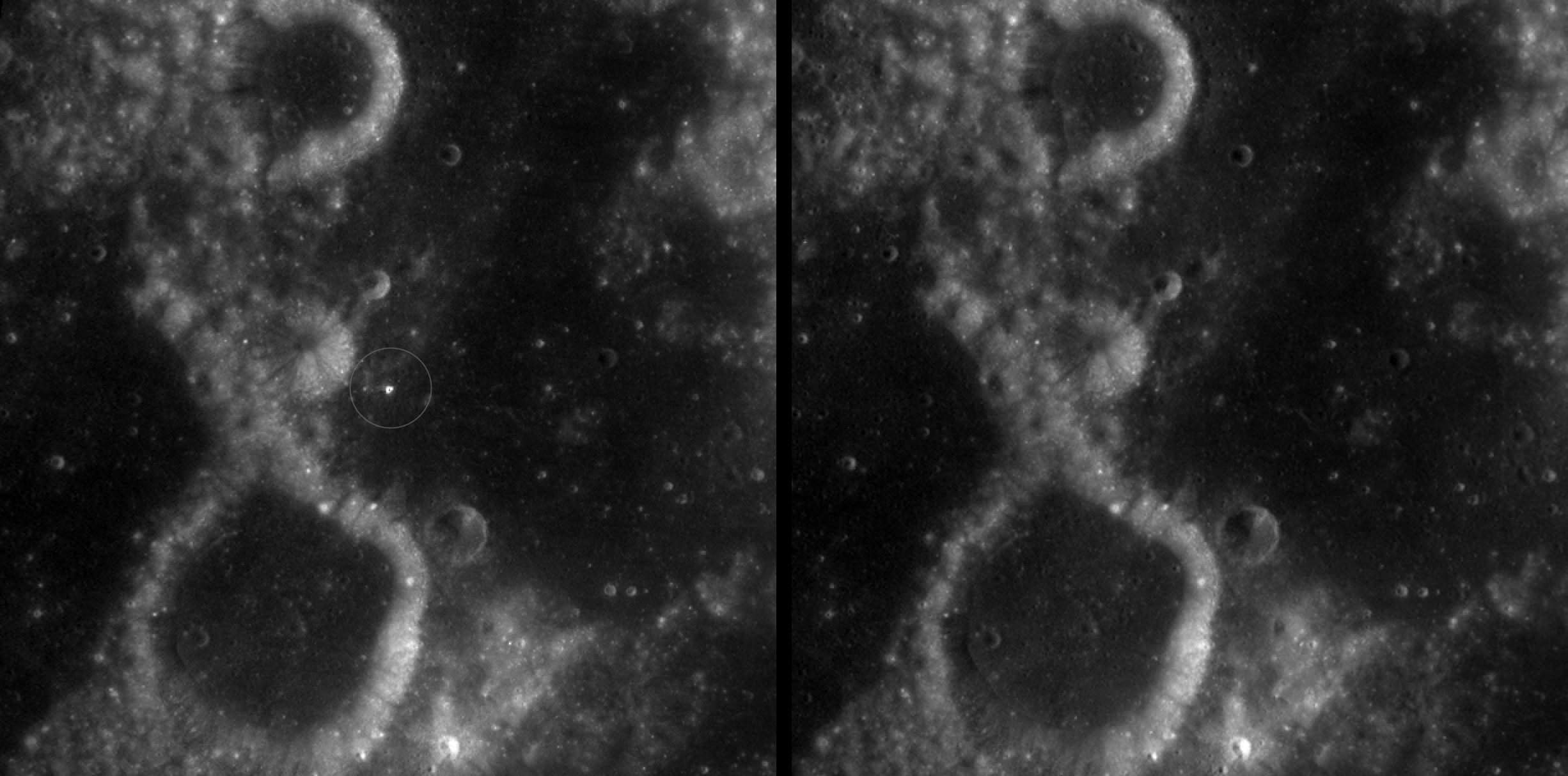
Two nearly identical black-and-white images appear side by side, separated by a vertical black line. Each shows a dark, uneven surface with scattered small circular depressions and several larger round formations with bright, raised rims. In the left image, a thin white circle marks a small, white spot near the center; there is no circled, white spot in the the corresponding area in the right image.
A zoomed-in view of McGetchin crater, circled on the left, next to a “before” image on the right. The panel on the left is made from images captured by NASA’s Lunar Reconnaissance Orbiter Wide-Angle Camera in summer 2025; the right panel was made from images taken in spring 2011. The white spot is not the crater itself, but rather material flung out of the crater, which formed when a rock, possibly this size of a three- to six‑story building, crashed into the Moon between April 11 and May 22, 2024 – a once-in-a-century event, as scientists reported on Sept. 15, 2026, in a pair of papers in Science Advances. The area shown in the images is 38 miles wide.
NASA Goddard/Intuitive Machines/Robert Wagner

Officially named McGetchin after pioneering lunar scientist Tom McGetchin, the crater formed on the Moon’s eastern edge sometime between April 11 and May 22, 2024, after a comet or asteroid the size of a three- to six-story building hit the surface.
 
The crash left a crater, 728 feet wide, that spans the length of two football fields. And at 141 feet deep, the crater could fit three vertically stacked yellow school buses.
 
Scientists estimate that an impact of this magnitude happens on the Moon about once in a century or even longer.

Moon takes some hits

For more than 17 years, LRO has been circling the Moon and using its seven instruments to map the topography, surface composition, temperature, and radiation environment there. The spacecraft’s team has identified at least 1,000 new impact craters throughout the mission and flagged 100,000 more surface changes from an object smashing into the Moon or from the debris that flung out after.

With no atmosphere to slow them or burn them up, space rocks and other objects easily reach the lunar surface. Most are much smaller compared to the object that carved out McGetchin crater. The smallest craters scientists can distinguish from LRO images are about 30 feet wide, the length of a three-story building laid on its side, made by rocks about 43 inches wide, the size of a monster-truck tire. Scientists estimate that impacts of this scale produce about 140 new craters across the Moon each year. But most new ones are made by microscopic projectiles that leave holes too small to identify in orbital images.

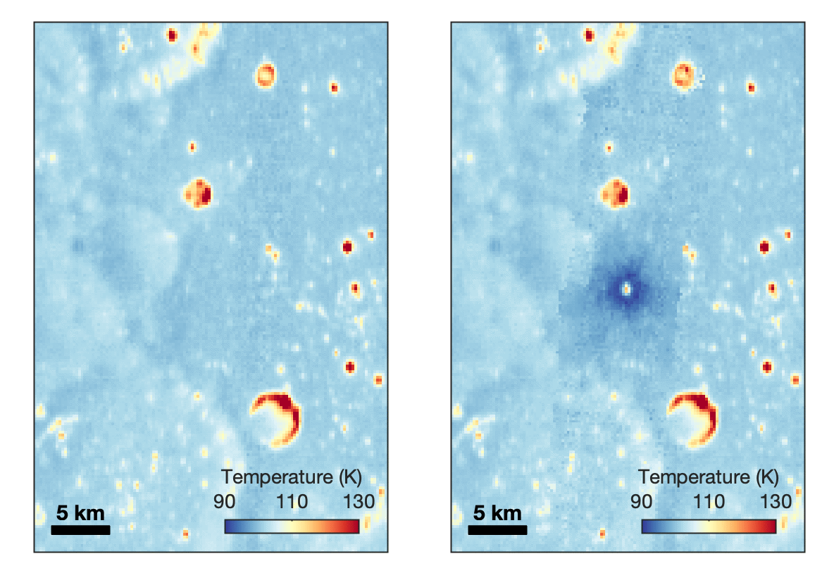
With its numerous instruments, the spacecraft can observe changes to the lunar surface that aren’t apparent in the LROC images alone. After the crater was discovered, scientists working with LRO’s thermal instrument, Diviner, made follow-up observations of the site. They found a 4-mile-wide area around the crater that is about 16 degrees Fahrenheit cooler at night than its surroundings.

Animated temperature map that alternates between two images. A vertical strip through the center blinks on and off, revealing a dark blue circular area surrounding a small white spot near the middle. The pale blue map also contains scattered yellow, orange, and red spots and rings, including a large, curved red-and-yellow feature near the lower center. A 5-kilometer scale bar appears at lower left, and a color key ranges from 90 kelvin in dark blue to 130 kelvin in dark red.
This animated image set shows an area on the eastern limb of the Moon before and after McGetchin crater formed there sometime between April 11 and May 22, 2024. The post-impact image was constructed using data taken by NASA’s Lunar Reconnaissance Orbiter (LRO) thermal instrument, Diviner, between Nov. 15, 2025, and Feb. 18, 2026, after scientists discovered the crater in visible-light images taken by LRO’s Wide-Angle Camera. Pre-impact temperatures are from the Diviner Global High-Resolution Mosaics (GHRM). The crater formed on the Moon after a comet or asteroid, possibly the size of a six-story building, hit the surface in a rare, once-in-a-century collision. The dark blue strip that flashes into view reveals a 4-mile-wide “cold spot” around the crater that is about 16 degrees Fahrenheit cooler at night than its surroundings. This cooling happens because an impact fluffs up regolith around a crater, making it less dense and therefore less able to retain heat. Scientists on the Diviner team reported this finding in a paper published on Sept. 16, 2026, in Science Advances. The red and yellow spots indicate areas typically associated with rocks excavated by long-ago impacts which, though still at cryogenic temperatures like their surroundings, remain slightly warmer at night.
NASA Goddard/UCLA/JHU APL

Reporting in a second paper Wednesday in the same journal, researchers say that the cooling happens because the impact fluffs up the regolith around the crater, making it less dense and therefore less able to retain heat.

The large extent of this “cold spot” is striking, scientists say, because it shows that impacts can modify the Moon’s surface far beyond the crater itself. These physical changes could affect how rover wheels interact with the surface, for instance.

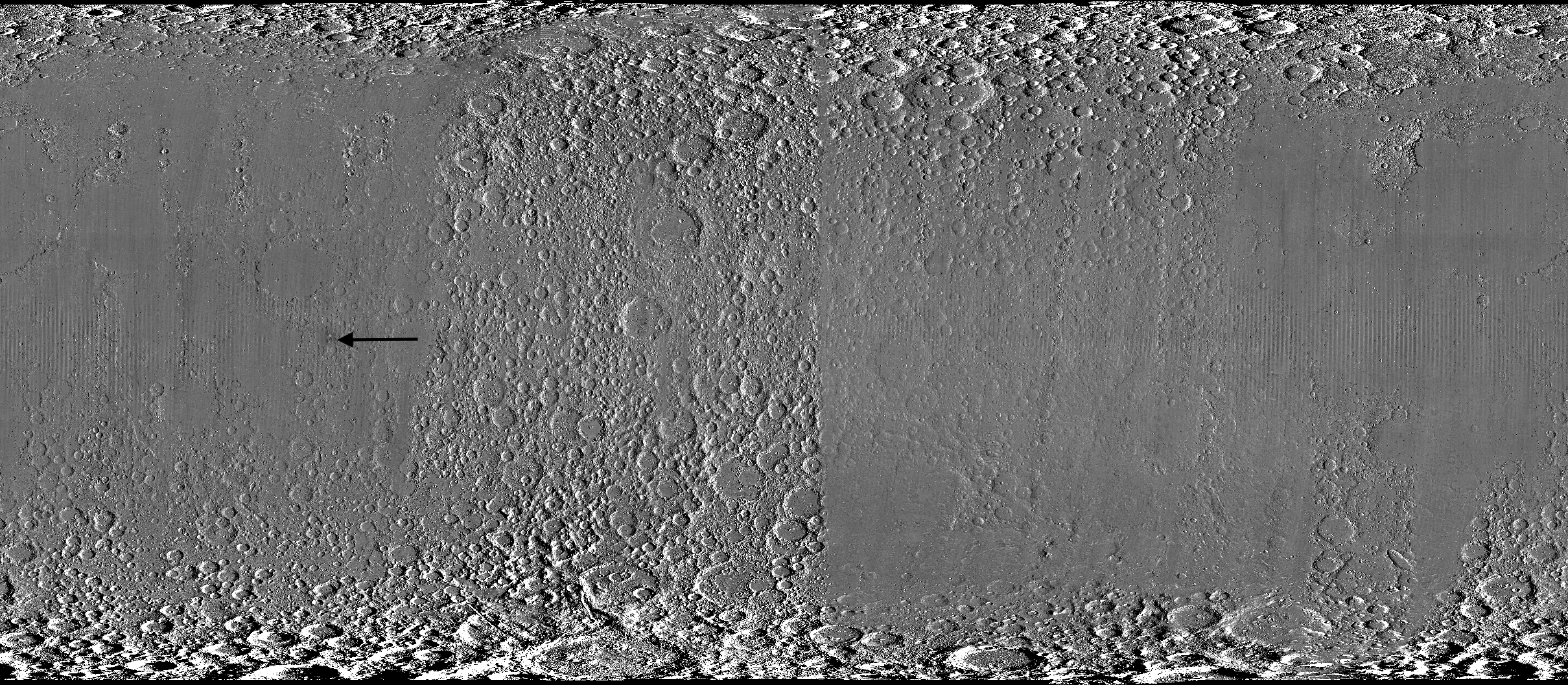
Wide black-and-white image of a rough, uneven surface densely covered with circular depressions and raised areas. The upper and lower edges are especially rugged, while the center is smoother and divided by subtle vertical bands. A black arrow left of center points toward a faint, narrow vertical mark.
A global view of the Moon made by stitching together hundreds of images from the Wide-Angle Camera aboard NASA’s Lunar Reconnaissance Orbiter (LRO). Robert Wagner, image processing specialist for LRO, made this map using two sets of mages taken several years apart. He used a software designed to highlight any changes between the two sets. Anything that stayed the same turned gray; anything different showed up as bright or dark patches. A black arrow just left of center points to McGetchin crater.
NASA Goddard/Intuitive Machines/Robert Wagner

Road to discovery

The LROC system collects images from about 60 miles above the Moon as LRO loops from pole to pole. The system includes two cameras that capture high‑resolution black‑and‑white images and one camera for moderate‑resolution multispectral images. Over the years and thousands of passes, scientists have built maps detailed enough to spot not only new craters, but also landslides, landers, seismic faults, and even hints of lava tubes.

LROC scientists regularly analyze close-up images of small portions of the Moon’s surface taken by the Narrow-Angle Camera. Using these images, they look for changes that are typically less than 30 feet across. But every few years the team searches for large (wider than 150 feet) features by creating global Moon maps and comparing them to older versions.

Square black-and-white image of a dark, uneven surface. At the center is a dark, roughly circular depression surrounded by a bright irregular area, with long streaks of lighter material radiating outward in all directions.
An overhead, close-up view of McGetchin crater that was taken on Dec. 5, 2025, by NASA’s Lunar Reconnaissance Orbiter (LRO) Narrow-Angle Camera (NAC). After the crater was discovered on Oct. 24, 2025, in global images from LRO’s Wide-Angle Camera, which captures broad views with pixels the size of American football fields, scientists turned to the NAC, which takes much sharper views at about 3 feet per pixel. The NAC images, taken as LRO flew over the impact site again, revealed the crater size, shape, and how the surrounding terrain was affected by the impact that carved McGetchin. The image covers an area that’s ¾ mile wide.
NASA Goddard/Intuitive Machines
Square black-and-white image of a dark, gently uneven surface scattered with small circular depressions. Near the center is a small oval crater with a bright raised rim and dark interior. Fine, bright streaks radiate outward from the crater across the surrounding surface.
This view from the side (55° away from straight down) towards the east, covers an area of the Moon that’s about 1.5 miles wide. It was taken by NASA’s Lunar Reconnaissance Orbiter Narrow-Angle Camera on March 3, 2026.
NASA Goddard/Intuitive Machines

That’s what Wagner was doing on Oct. 24, 2025, when he came across McGetchin. Using images from LROC’s Wide-Angle Camera, which captures broad views with pixels the size of football fields, he stacked hundreds of “before” and “after” frames with software designed to highlight change. Anything that stayed the same turned gray while anything different showed up as bright or dark patches.

While the process sounds straightforward, spotting real craters requires a lot of manual work. The software flags every tiny shift in lighting or shadow, generating hundreds of false alarms. For this reason, Wagner typically verifies the software, looking for small fuzzy halos around pixel‑wide bright points, which indicate splashes of regolith around a new crater.

Spanning hundreds of pixels, McGetchin stood out immediately. “It was by far the most obvious impact debris pattern I’ve ever seen in one of these images,” Wagner said.

After his discovery, scientists turned to the Narrow-Angle Camera, which takes much sharper views at about 3 feet per pixel. This camera’s close-up images, taken as LRO flew over the impact site again, revealed the crater size, shape, and how the surrounding terrain was affected. These images also helped researchers estimate the size and force of the rock fragment that formed the new crater, details that are expected to appear in a future paper.

Banner image caption: A zoomed-in view of the Moon, with debris around McGetchin crater visible as a white spot circled by a dark halo just right of center of the image (marked with black arrows). This is the view that Robert Wagner saw on Oct. 24, 2025, during a routine data-quality check. Wagner is an image processing specialist for NASA’s Lunar Reconnaissance Orbiter Camera, a system of three cameras. Using images from the Wide-Angle Camera (WAC), which captures broad views with pixels the size of American football fields, he stacked hundreds of images captured by WAC over the last several years with software designed to highlight change. Anything that stayed the same is gray; anything that changed showed up as bright or dark patches. The stripes in the image are due to slight changes in lighting between the older and newer images. This image composite shows an area of the Moon approximately 900 miles across.

About the Author

Lonnie Shekhtman

Lonnie Shekhtman

Senior Science Writer

Shekhtman helps communicate NASA planetary science to the world through news and feature stories on NASA.gov, videos for NASA+ and YouTube, and by working with the media. She reports on lunar and Mars science and exploration; NASA's search for life; missions to Venus, Titan, and Jupiter's Trojan asteroids; and many other topics related to NASA's exploration of our solar system and beyond.

Keep Exploring

Discover More Topics From NASA

Simplified Summary

Scientists discovered a crater on the Moon that formed sometime between April 11 and May 22, 2024, after a comet or asteroid the size of a three- to six-story building hit the surface.   The crash left a crater, 728 feet wide, that spans the length of two football fields. And at 141 feet deep, the crater could fit three vertically stacked yellow school buses.

The post NASA’s Moon Orbiter Spots New, ‘Once-in-Century’ Moon Crater appeared first on NASA Science.

NASA’s Moon Orbiter Spots New, ‘Once-in-Century’ Moon Crater

16 September 2026 at 19:06
6 Min Read

NASA’s Moon Orbiter Spots New, ‘Once-in-Century’ Moon Crater

Black-and-white image of a textured, cratered surface. Two black arrows near the center point inward toward a small, dark, circular feature.
A zoomed-in view of the Moon made from images from NASA’s Lunar Reconnaissance Orbiter Camera. (More information at the bottom of article.)
Credits:
NASA Goddard/Intuitive Machines/Robert Wagner

It started as a routine data-quality check. But as Robert Wagner, a scientist with NASA’s Lunar Reconnaissance Orbiter (LRO), scanned a giant Moon map on his computer screen, an unusually large bright spot circled by a dark halo caught his eye, as it implied that surface material in that area had been shaken up.

“I just stopped, dropped everything, and started looking into what that spot was,” said Wagner, an image-processing specialist from Intuitive Machines who works with data from the Lunar Reconnaissance Orbiter Camera (LROC) system.

By comparing before and after images of the Moon, Wagner realized he had discovered the largest, newly formed crater ever found in the solar system, as scientists reported Wednesday in Science Advances. This discovery highlights the value of NASA’s Moon orbiter data in studying a dynamic landscape as the agency advances a sustained human presence and expanded scientific and commercial activity on the Moon.

Two nearly identical black-and-white images appear side by side, separated by a vertical black line. Each shows a dark, uneven surface with scattered small circular depressions and several larger round formations with bright, raised rims. In the left image, a thin white circle marks a small, white spot near the center; there is no circled, white spot in the the corresponding area in the right image.
A zoomed-in view of McGetchin crater, circled on the left, next to a “before” image on the right. The panel on the left is made from images captured by NASA’s Lunar Reconnaissance Orbiter Wide-Angle Camera in summer 2025; the right panel was made from images taken in spring 2011. The white spot is not the crater itself, but rather material flung out of the crater, which formed when a rock, possibly this size of a three- to six‑story building, crashed into the Moon between April 11 and May 22, 2024 – a once-in-a-century event, as scientists reported on Sept. 15, 2026, in a pair of papers in Science Advances. The area shown in the images is 38 miles wide.
NASA Goddard/Intuitive Machines/Robert Wagner

Officially named McGetchin after pioneering lunar scientist Tom McGetchin, the crater formed on the Moon’s eastern edge sometime between April 11 and May 22, 2024, after a comet or asteroid the size of a three- to six-story building hit the surface.
 
The crash left a crater, 728 feet wide, that spans the length of two football fields. And at 141 feet deep, the crater could fit three vertically stacked yellow school buses.
 
Scientists estimate that an impact of this magnitude happens on the Moon about once in a century or even longer.

Moon takes some hits

For more than 17 years, LRO has been circling the Moon and using its seven instruments to map the topography, surface composition, temperature, and radiation environment there. The spacecraft’s team has identified at least 1,000 new impact craters throughout the mission and flagged 100,000 more surface changes from an object smashing into the Moon or from the debris that flung out after.

With no atmosphere to slow them or burn them up, space rocks and other objects easily reach the lunar surface. Most are much smaller compared to the object that carved out McGetchin crater. The smallest craters scientists can distinguish from LRO images are about 30 feet wide, the length of a three-story building laid on its side, made by rocks about 43 inches wide, the size of a monster-truck tire. Scientists estimate that impacts of this scale produce about 140 new craters across the Moon each year. But most new ones are made by microscopic projectiles that leave holes too small to identify in orbital images.

With its numerous instruments, the spacecraft can observe changes to the lunar surface that aren’t apparent in the LROC images alone. After the crater was discovered, scientists working with LRO’s thermal instrument, Diviner, made follow-up observations of the site. They found a 4-mile-wide area around the crater that is about 16 degrees Fahrenheit cooler at night than its surroundings.

Animated temperature map that alternates between two images. A vertical strip through the center blinks on and off, revealing a dark blue circular area surrounding a small white spot near the middle. The pale blue map also contains scattered yellow, orange, and red spots and rings, including a large, curved red-and-yellow feature near the lower center. A 5-kilometer scale bar appears at lower left, and a color key ranges from 90 kelvin in dark blue to 130 kelvin in dark red.
This animated image set shows an area on the eastern limb of the Moon before and after McGetchin crater formed there sometime between April 11 and May 22, 2024. The post-impact image was constructed using data taken by NASA’s Lunar Reconnaissance Orbiter (LRO) thermal instrument, Diviner, between Nov. 15, 2025, and Feb. 18, 2026, after scientists discovered the crater in visible-light images taken by LRO’s Wide-Angle Camera. Pre-impact temperatures are from the Diviner Global High-Resolution Mosaics (GHRM). The crater formed on the Moon after a comet or asteroid, possibly the size of a six-story building, hit the surface in a rare, once-in-a-century collision. The dark blue strip that flashes into view reveals a 4-mile-wide “cold spot” around the crater that is about 16 degrees Fahrenheit cooler at night than its surroundings. This cooling happens because an impact fluffs up regolith around a crater, making it less dense and therefore less able to retain heat. Scientists on the Diviner team reported this finding in a paper published on Sept. 16, 2026, in Science Advances. The red and yellow spots indicate areas typically associated with rocks excavated by long-ago impacts which, though still at cryogenic temperatures like their surroundings, remain slightly warmer at night.
NASA Goddard/UCLA/JHU APL

Reporting in a second paper Wednesday in the same journal, researchers say that the cooling happens because the impact fluffs up the regolith around the crater, making it less dense and therefore less able to retain heat.

The large extent of this “cold spot” is striking, scientists say, because it shows that impacts can modify the Moon’s surface far beyond the crater itself. These physical changes could affect how rover wheels interact with the surface, for instance.

Wide black-and-white image of a rough, uneven surface densely covered with circular depressions and raised areas. The upper and lower edges are especially rugged, while the center is smoother and divided by subtle vertical bands. A black arrow left of center points toward a faint, narrow vertical mark.
A global view of the Moon made by stitching together hundreds of images from the Wide-Angle Camera aboard NASA’s Lunar Reconnaissance Orbiter (LRO). Robert Wagner, image processing specialist for LRO, made this map using two sets of mages taken several years apart. He used a software designed to highlight any changes between the two sets. Anything that stayed the same turned gray; anything different showed up as bright or dark patches. A black arrow just left of center points to McGetchin crater.
NASA Goddard/Intuitive Machines/Robert Wagner

Road to discovery

The LROC system collects images from about 60 miles above the Moon as LRO loops from pole to pole. The system includes two cameras that capture high‑resolution black‑and‑white images and one camera for moderate‑resolution multispectral images. Over the years and thousands of passes, scientists have built maps detailed enough to spot not only new craters, but also landslides, landers, seismic faults, and even hints of lava tubes.

LROC scientists regularly analyze close-up images of small portions of the Moon’s surface taken by the Narrow-Angle Camera. Using these images, they look for changes that are typically less than 30 feet across. But every few years the team searches for large (wider than 150 feet) features by creating global Moon maps and comparing them to older versions.

Square black-and-white image of a dark, uneven surface. At the center is a dark, roughly circular depression surrounded by a bright irregular area, with long streaks of lighter material radiating outward in all directions.
An overhead, close-up view of McGetchin crater that was taken on Dec. 5, 2025, by NASA’s Lunar Reconnaissance Orbiter (LRO) Narrow-Angle Camera (NAC). After the crater was discovered on Oct. 24, 2025, in global images from LRO’s Wide-Angle Camera, which captures broad views with pixels the size of American football fields, scientists turned to the NAC, which takes much sharper views at about 3 feet per pixel. The NAC images, taken as LRO flew over the impact site again, revealed the crater size, shape, and how the surrounding terrain was affected by the impact that carved McGetchin. The image covers an area that’s ¾ mile wide.
NASA Goddard/Intuitive Machines
Square black-and-white image of a dark, gently uneven surface scattered with small circular depressions. Near the center is a small oval crater with a bright raised rim and dark interior. Fine, bright streaks radiate outward from the crater across the surrounding surface.
This view from the side (55° away from straight down) towards the east, covers an area of the Moon that’s about 1.5 miles wide. It was taken by NASA’s Lunar Reconnaissance Orbiter Narrow-Angle Camera on March 3, 2026.
NASA Goddard/Intuitive Machines

That’s what Wagner was doing on Oct. 24, 2025, when he came across McGetchin. Using images from LROC’s Wide-Angle Camera, which captures broad views with pixels the size of football fields, he stacked hundreds of “before” and “after” frames with software designed to highlight change. Anything that stayed the same turned gray while anything different showed up as bright or dark patches.

While the process sounds straightforward, spotting real craters requires a lot of manual work. The software flags every tiny shift in lighting or shadow, generating hundreds of false alarms. For this reason, Wagner typically verifies the software, looking for small fuzzy halos around pixel‑wide bright points, which indicate splashes of regolith around a new crater.

Spanning hundreds of pixels, McGetchin stood out immediately. “It was by far the most obvious impact debris pattern I’ve ever seen in one of these images,” Wagner said.

After his discovery, scientists turned to the Narrow-Angle Camera, which takes much sharper views at about 3 feet per pixel. This camera’s close-up images, taken as LRO flew over the impact site again, revealed the crater size, shape, and how the surrounding terrain was affected. These images also helped researchers estimate the size and force of the rock fragment that formed the new crater, details that are expected to appear in a future paper.

Banner image caption: A zoomed-in view of the Moon, with debris around McGetchin crater visible as a white spot circled by a dark halo just right of center of the image (marked with black arrows). This is the view that Robert Wagner saw on Oct. 24, 2025, during a routine data-quality check. Wagner is an image processing specialist for NASA’s Lunar Reconnaissance Orbiter Camera, a system of three cameras. Using images from the Wide-Angle Camera (WAC), which captures broad views with pixels the size of American football fields, he stacked hundreds of images captured by WAC over the last several years with software designed to highlight change. Anything that stayed the same is gray; anything that changed showed up as bright or dark patches. The stripes in the image are due to slight changes in lighting between the older and newer images. This image composite shows an area of the Moon approximately 900 miles across.

About the Author

Lonnie Shekhtman

Lonnie Shekhtman

Senior Science Writer

Shekhtman helps communicate NASA planetary science to the world through news and feature stories on NASA.gov, videos for NASA+ and YouTube, and by working with the media. She reports on lunar and Mars science and exploration; NASA’s search for life; missions to Venus, Titan, and Jupiter’s Trojan asteroids; and many other topics related to NASA’s exploration of our solar system and beyond.

Keep Exploring

Discover More Topics From NASA

Simplified Summary

Scientists discovered a crater on the Moon that formed sometime between April 11 and May 22, 2024, after a comet or asteroid the size of a three- to six-story building hit the surface.
 
The crash left a crater, 728 feet wide, that spans the length of two football fields. And at 141 feet deep, the crater could fit three vertically stacked yellow school buses.

A Single Asteroid Impact May Have Shaped Mars’ Moon Deimos

16 September 2026 at 13:00

University of Bern simulations and ESA Hera observations point to one non-destructive asteroid impact as the source of Deimos’ southern depression and dusty surface.

The post A Single Asteroid Impact May Have Shaped Mars’ Moon Deimos appeared first on Curiosmos.

New Study Explains Why Venus Has No Moon

15 September 2026 at 19:38
NASA’s Mariner 10 spacecraft captured this view of Venus in February 1974. Image credit: NASA / JPL-Caltech.

Dr. Stephen Kane from the University of California, Riverside and colleagues offer a tidy explanation for one of the Solar System’s enduring puzzles: why Venus, so similar to Earth in size and mass, has no moon at all.

The post New Study Explains Why Venus Has No Moon appeared first on Sci.News: Breaking Science News.

Celebrate International Observe the Moon Night with NASA

15 September 2026 at 17:15

In April, the world watched as four humans circled the Moon for the first time in over 50 years with NASA’s Artemis II mission. On Saturday, Sept. 19, the public is invited to look up again with NASA events across the country, including the International Observe the Moon Night celebration held at NASA’s Goddard Space Flight Center Visitor Center in Greenbelt, Maryland.

Graphic advertising International Observe the Moon Night.
This year, NASA will celebrate International Observe the Moon Night with people around the world on Sept. 19.
NASA/Vi Nguyen

International Observe the Moon Night is an annual celebration that brings people together to learn about the Moon and explore our connection to Earth’s nearest celestial neighbor. Since the program began in 2010, people around the world have participated through lunar observations, hands-on activities, artwork, music, and more.
 
At NASA Goddard, this year’s celebration will highlight the agency’s ongoing exploration of the Moon, including the historic Artemis II mission. Visitors can peer behind the scenes to learn more about what it took to make Artemis II’s journey around the Moon a success and discover how Goddard scientists and engineers are helping advance our understanding of the Moon, solar system, and beyond.
 
The event will run from 6 p.m. to 9 p.m. EDT.
 
Throughout the event at NASA Goddard, visitors can take part in interactive hands-on activities, create artwork and crafts, and capture selfies at a photo kiosk. Telescopes will also be set up outside (depending on weather), giving attendees an opportunity to observe the Moon and other astronomical objects up close. Inside the Visitor Center, guests can even see a real Apollo 14 Moon rock on display.

  • At 6:30 p.m., Dr. Amanda Nahm, planetary scientist at NASA Headquarters, will explore the lunar science and Moon joy from Artemis II.
  • At 7:30 p.m., Ernie Wright, scientific visualizer at NASA Goddard, will offer a more technical look at how scientists use real data to create videos and visualizations of the Moon.
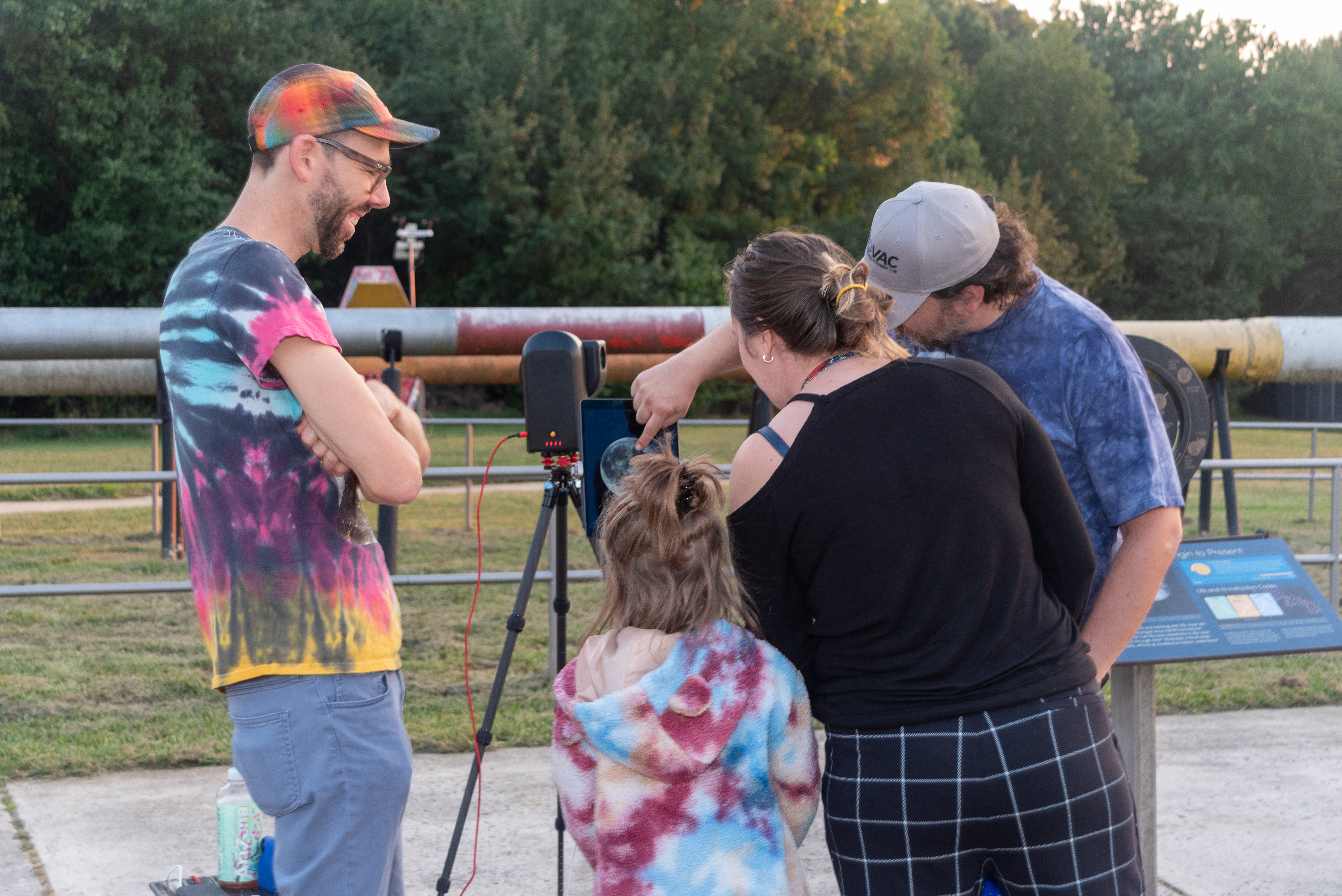
A child and two adults look at a tablet screen with a telescope’s display showing the full Moon. Another person stands to the left, smiling and looking on.
A family observes the Moon through a telescope at NASA’s Goddard Space Flight Center in Greenbelt, Md. during the International Observe the Moon Night celebration on Saturday, Sept. 14, 2024.
NASA/Britt Griswold

The event will also offer a chance to learn more about the groundbreaking research happening at NASA Goddard as scientists work to unlock the secrets of the Moon with missions like the Lunar Reconnaissance Orbiter (LRO) and explore our solar system and the universe beyond.
 
International Observe the Moon Night at Goddard is free and family friendly. Registration is not required, although registering in advance will help the Visitor Center team plan for the event. The event will take place rain or shine, and free parking is available at the Visitor Center.
 
Additional event details, including registration, accessibility and other logistics: https://www.nasa.gov/goddard/visitor-center/events-and-programs/.
 
For people who cannot travel to Greenbelt, there are opportunities to participate in International Observe the Moon Night from all around the planet. Join lunar observers around the world by observing the Moon with friends and family, attending a virtual event or finding an event in your area. Learn more and register your participation at go.nasa.gov/ObserveTheMoon.
 
International Observe the Moon Night is sponsored by NASA’s LRO mission and the Solar System Exploration Division of NASA’s Goddard Space Flight Center, with support from many partners. The celebration is a way for people to pause and look up at our future destination, as NASA prepares for deep space missions to the Moon and beyond.
 
To learn about NASA’s Artemis program, visit:
https://www.nasa.gov/artemis
 
To learn about LRO, visit:
https://www.nasa.gov/lro

Share

Details

Last Updated
Sep 15, 2026

Scientists Discover the Moon May Have Formed in Just Five Hours

15 September 2026 at 14:13
Moon FormationThe Moon may have emerged largely intact within hours of the colossal impact that shaped its birth. Earth has an unusually large moon for a planet of its size and position in the solar system, yet scientists still do not fully understand how that companion came to exist. Now, researchers from the Southwest Research Institute [...]

Mercury Has Shrunk Even More than Planetary Scientists Thought

14 September 2026 at 19:41
This color image of Mercury was generated from three MESSENGER images taken through filters sensitive to light in different wavelengths. Image credit: NASA / Johns Hopkins University Applied Physics Laboratory / Carnegie Institution of Washington.

The Solar System’s smallest planet has contracted by nearly 19 km (12 miles) across, as crater debris masked telltale wrinkles on its surface, according to new research led by the German Aerospace Center’s Institute of Space Research.

The post Mercury Has Shrunk Even More than Planetary Scientists Thought appeared first on Sci.News: Breaking Science News.

Mercury May Have Shrunk Far More Than Scientists Realized—and Its Cratered Surface Was Hiding the Evidence

14 September 2026 at 13:35

Mercury has been slowly shrinking for billions of years. But scientists studying the smallest planet in the solar system may have overlooked just how dramatic that transformation has been because some of the evidence has literally been buried.

A new study suggests Mercury’s battered, crater-covered surface has concealed a significant fraction of the faults created as the planet cooled and contracted. After accounting for those hidden geological structures, researchers estimate Mercury may have shrunk by as much as 7.2 miles (11.6 kilometers) in radius—up to 30% more than previous estimates based on the same tectonic record.

The findings could alter models of how Mercury’s interior evolved and raise an interesting possibility beyond the planet itself. For instance, scientists may also be underestimating how much other rocky worlds, particularly the Moon, have contracted.

“Combined with the contractional strain map from Broquet and Andrews-Hanna (2026a), we show that radial contraction may have been underestimated by 10%–30%,” researchers write. “Our radial contraction correction should be considered as a lower bound.”

In the study published in Geophysical Research Letters, researchers led by Dr. Gaku Nishiyama of the German Aerospace Center (DLR) examined a longstanding mystery in Mercury’s geology.

As a rocky planet loses heat, its interior contracts. Much like the skin of a drying fruit, the planet’s rigid exterior must accommodate a shrinking interior, producing faults and enormous cliff-like features known as lobate scarps, along with wrinkle ridges and other shortening structures.

Scientists therefore use the crustal shortening recorded by these structures as a geological ruler to determine how much Mercury has contracted.

The problem is that those structures aren’t distributed across Mercury the way scientists might expect.

If cooling caused the entire planet to contract, the resulting deformation should be comparatively widespread. Instead, previous mapping has revealed regions filled with large scarps alongside enormous areas where surprisingly few contractional structures have been identified.

Dr. Nishiyama and his colleagues investigated whether at least part of that discrepancy could be an illusion created by Mercury’s extraordinarily battered surface.

Mercury’s Craters May Be Hiding Its Wrinkles

The researchers constructed a global map of Mercury’s surface roughness using topographic measurements acquired from NASA’s MESSENGER mission and a global digital terrain model produced from spacecraft imagery.

They then compared that roughness with previously cataloged tectonic structures.

Findings showed that fault scarps and other shortening structures were preferentially identified in smoother terrain, while rougher regions contained substantially fewer detectable structures. The relationship remained apparent across geographic scales extending to roughly 93 miles or about 150 kilometers.

That is counterintuitive because tectonic ridges themselves create topographic roughness. If roughness and plate movements were unrelated, areas with scarps might be expected to be slightly rougher than the surrounding terrain.

Instead, the researchers found the opposite.

One explanation is evident around relatively young impact craters such as Rachmaninoff. Large impacts blasted enormous quantities of debris across the surrounding landscape, producing thick blankets of material and secondary craters. In some locations, long tectonic structures appear to lose relief as they approach these deposits—consistent with the older structures being progressively hidden under impact material.

Other faults may still exist but become difficult to recognize against heavily cratered terrain. Once the surrounding topography becomes rough enough, a weathered ridge only a little higher than the background landscape can effectively disappear into the geological noise.

There is also a third possibility.

Heavily cratered regions may contain thick, porous layers of broken rock called regolith. During planetary contraction, some deformation could be absorbed as pores collapse rather than producing large faults visible from orbit. Alternatively, deformation could create faults too small for current observations to resolve. The researchers say available evidence cannot yet rule out that possibility.

Mercury Could Have Shrunk by More Than 7 Miles

Whatever mechanism is responsible, Dr. Nishiyama and his colleagues argue the relationship creates a systematic bias, where scientists see more evidence of contraction where Mercury’s surface makes that evidence easier to preserve and identify.

The team developed a correction using comparatively smooth regions, where tectonic structures appear less affected by this bias.

Applied to an earlier global estimate of 5.2 miles (8.3 kilometers) of radial contraction, the correction increased Mercury’s estimated shrinkage to roughly 7.2 miles or about 11.6 kilometers.

Depending on which tectonic structures are included, the researchers estimate surface roughness could have caused previous calculations to underestimate Mercury’s contraction by roughly 10% to 30%. They also caution that their corrected figure may itself represent a lower limit.

Ultimately, Mercury’s shrinking surface effectively records what has happened deep inside the planet.

The amount of contraction constrains how quickly Mercury lost heat, the thickness of its insulating regolith, the abundance of heat-producing elements, and even the composition and freezing history of its enormous metallic core. The revised estimate, for example, favors models involving a thinner regolith and lower sulfur content in Mercury’s core than some previous estimates.

Scientists may soon get a much sharper look.

The ESA-JAXA BepiColombo mission’s laser altimeter will eventually measure Mercury’s topography at scales as small as about 330 feet or 100 meters, possibly revealing geological relationships that MESSENGER could not resolve.

And Mercury may not be the only world whose geological record has been hiding in plain sight.

The Moon’s highlands are even rougher than Mercury’s cratered plains—by roughly 40% at the little-over 6-mile (10-kilometer) scale examined by the researchers. Yet evidence suggests the Moon contracted less than some thermal models estimate. If rough terrain similarly hides lunar faults, part of that difference might reflect structures scientists haven’t been able to see.

In other words, Mercury’s missing wrinkles may expose a wider problem in planetary geoscience. The more battered an ancient world becomes, the more effectively its later surface can erase the visible record of what happened before it.

“Investigating roughness alongside tectonic landforms may therefore refine our understanding of the lunar thermal evolution as well,” researchers conclude. “Mars could also be subject to this roughness effect, while topographic smoothing due to fluvial and aeolian processes may introduce more complex correlation between surface roughness and shortening structures.”

Study: Nishiyama, G., Broquet, A., Tosi, N., Preusker, F., Stark, A., Hussmann, H., & Hauber, E. “Underestimation of Planetary Contraction Due to Obscuration by Surface Roughness: The Case of Mercury.” Geophysical Research Letters 53, (2026). 

Tim McMillan is a retired law enforcement executive, investigative reporter and co-founder of The Debrief. His writing typically focuses on defense, national security, the Intelligence Community and topics related to psychology. You can follow Tim on Twitter: @LtTimMcMillan.  Tim can be reached by email: tim@thedebrief.org or through encrypted email: LtTimMcMillan@protonmail.com 

Mercury may not need an ancient dynamo to explain its magnetic crust

11 September 2026 at 15:45

A new study using data from a space mission suggests that most of Mercury’s crustal magnetic fields can be explained by iron and other magnetized rocks in the crust responding to the planet’s weak present-day core magnetic field, rather than from an ancient field, as had been inferred previously. Mercury is the only solar-system planet other than Earth to possess both a global magnetic field arising from its core and a crustal magnetic field resulting from rocks that were magnetized in either the present-day or an ancient core field. Present-day (induced) magnetization reveals the location and amount of iron in the crust, whereas ancient (remanent) magnetization records the planet’s dynamo history.

NASA’s MErcury, Surface, Space ENvironment, GEochemistry and Ranging (MESSENGER) mission observed the planet in 2011–2015. Data from the mission are allowing scientists to explore the strength and distribution of Mercury’s magnetic field. During the mission, a last-minute decision was made “to reduce the orbit altitude thereby allowing crustal fields to be detected” explains Lon Hood at the Lunar and Planetary Laboratory at the University of Arizona. He has worked extensively on Mercury’s crustal magnetism using the MESSENGER data but was not involved in the new study.

Crustal magnetism was expected to be “partly due to remanent magnetization dating from the time when the crustal sources formed in the planetary magnetic field,” Hood says. This interpretation is drawn from earlier analyses of the mission data. But a key challenge in understanding the crustal magnetic field remained – how to delineate the contributions of induced and remanent magnetization. Separating the relative contributions of ancient and present-day induced magnetization on the crustal magnetic field can reveal new ways of understanding the spatial abundance of magnetic rocks, variations of magnetic properties of crustal minerals, and the dynamo history of Mercury.

New insights from old data

The new study, led by Catherine Johnson at the University of British Columbia in Vancouver, uses field observations of Mercury’s crustal magnetic fields from MESSENGER to develop a magnetization model of the planet and identify sources of its magnetization. The researchers calculated the expected induced magnetization strength using the low-altitude observations with assumptions on the crustal thickness, magnetic mineralogy, iron content, and the present-day core field.

In line with previous studies, the researchers found that the largest magnetization strengths occur in the Caloris region, along with localized signals elsewhere. The spatial pattern of magnetization strength, however, does not consistently match the variation in near-surface iron content seen in MESSENGER spectroscopic data. Instead, magnetization strength correlates with crustal thickness, up to about 30 km, suggesting the magnetized rocks are concentrated within the upper part of the crust.

The researchers found that induced magnetization is relatively small, given the low iron content of the planet’s crust and its weak core field – about a hundred times weaker than Earth’s. Even so, they estimate that induced magnetization can fully account for the calculated magnetization strength across more than 85% of the area north of 38 °N. This assumes it extends through the crustal column to a depth of about 30 km, which means that no remanent magnetization is required to explain the observed crustal field over that majority of the mapped region. Areas where induced magnetization does not explain the observed crustal fields may be the result of iron delivered by ancient asteroid impacts, which would locally increase the induced magnetization. Elsewhere, a contribution from remanent magnetization may be required to explain the observed fields.

Towards better characterization

On Earth, the robust separation of induced and remanent magnetizations requires laboratory measurements of rock samples. For Mercury no such samples exist, so the magnetic properties of its crust must be inferred from satellite observations constrained by assumptions about the composition and magnetic behaviour of its rocks. The delineation in the new study depends on “assumptions about magnetic mineralogy that cannot be verified due to the lack of returned samples”, says Hood.

Better characterization of the crust’s low-field magnetic susceptibility – currently inferred from a limited number of laboratory measurements on meteorites and minerals believed to resemble Mercury’s crust – can advance our understanding of Mercury’s crustal fields. Better core-field models and higher-resolution iron maps from the European–Japanese BepiColombo mission could help. This mission comprises two spacecraft that launched in 2018 and is expected to run until 2029.

However, Hood says “there are no current plans for either spacecraft to approach near enough to the planet to detect or map more of the crustal magnetic field”. Although the spacecraft will eventually descend below 100 kilometres, giving us a first look at the southern hemisphere. Indeed, we may have a long wait before we have the complete picture because Hoods says, ” there are no plans to obtain samples of Mercury’s crustal rocks, which are needed to definitively determine the origin of the crustal magnetization”.

The researchers report their findings in PNAS.

The post Mercury may not need an ancient dynamo to explain its magnetic crust appeared first on Physics World.

Europe will go it alone on Venus mission after NASA yanks radar instrument

10 September 2026 at 20:09

The European Space Agency is moving "full steam ahead" with development of a robotic mission to Venus after NASA officials determined they were unlikely to fulfill a commitment to provide a US-built radar instrument for the spacecraft, the mission's project scientist said.

The European orbiter, named Envision, will map the Venusian surface at 10 times higher resolution than the last radar mission sent to Venus by NASA in the 1990s. The planet is enshrouded in a blanket of thick clouds of sulfuric acid, rendering its mysterious surface unseen by optical cameras in orbit. Radar is the most effective way to penetrate the clouds of Venus to reveal the terrain below, and scientists will use Envision to look for signs of active volcanism.

NASA and ESA signed a memorandum of understanding in 2024 outlining their partnership on Envision. NASA agreed to supply a US-made synthetic aperture radar instrument, Envision's primary means of mapping the surface of Venus, along with providing tracking and communications support through NASA's Deep Space Network. In exchange, ESA would include US researchers on Envision's science team. Europe would build the Envision spacecraft and the rest of its science instruments and provide the launch on an Ariane 6 rocket.

Read full article

Comments

© ESA/Paris Observatory/VR2Planets

4.6-Billion-Year-Old Meteorite Reveals a Surprisingly Strong Primordial Magnetic Field

Artistic Illustration of Early Solar System MagnetismAncient meteorite minerals reveal a surprisingly strong magnetic field from the solar system’s first 200,000 years. About 4.6 billion years ago, before the Sun and planets existed in their familiar forms, the solar system was a vast cloud of gas and dust. Within a few million years, this “solar nebula” collapsed and flattened into a [...]

Scientists May Have Cracked the Mystery of the Moon’s Unequal Hemispheres

10 September 2026 at 18:49
Earth Behind Far Side of MoonChang’e-6 samples suggest the Moon’s two very different sides may have formed when uneven heating drove magma from one hemisphere to the other. The Moon presents two dramatically different faces. Its Earth-facing hemisphere is rich in dark volcanic plains, while the farside is dominated by older highlands and a much thicker crust. New analyses of [...]

What Is the Solar System? How Our Cosmic Neighborhood Took Shape

10 September 2026 at 10:00

Look up at the night sky and it is easy to imagine a few bright worlds hanging in an empty blackness. But what are we really looking at when we say “the Solar System”? It is a family shaped by one star’s gravity, built from the same ancient disk of gas and dust, and still […]

The post What Is the Solar System? How Our Cosmic Neighborhood Took Shape appeared first on Curiosmos.

Earth May Not Be a Cosmic Fluke, New Simulations Suggest

9 September 2026 at 16:03
Exoplanet Ross 128 b Is Not Like EarthSolar system simulations starting from varied initial conditions suggest that Earth-like planets can emerge naturally from planet formation. Computer simulations of planetary systems can now begin from thousands of different starting conditions, allowing researchers to explore how worlds might emerge without assuming the final outcome. Over the past three decades, these models have advanced from [...]

Lava-Covered Planets Are Defying a Key Rule of Planetary Science

9 September 2026 at 14:53
Hot Lava World ExoplanetResearchers developed a model showing how lava-covered planets close to their stars can hold onto their atmospheres, which could help guide the search for life beyond our solar system. Some planets orbit so close to their stars that intense radiation should strip away their atmospheres. Yet several of these scorching, lava-covered worlds still retain thick [...]

Scientists Discover the 7 Stages a Meteoroid Goes Through Before Hitting Earth

8 September 2026 at 17:13
Huge Meteor Asteroid Slams Into EarthAn analysis of 75 meteorite falls identified seven distinct processes that occur as space rocks melt, break apart, and slow down before reaching the ground. A space rock entering Earth’s atmosphere does far more than simply “burn up.” By examining 75 meteorite falls recorded in videos and photographs, researchers identified seven distinct stages that shape [...]

Magnetism likely played a key role in early solar system formation

7 September 2026 at 09:00

The oldest known solids in the solar system contain evidence that the protoplanetary disc that went on to form the planets around our Sun experienced a magnetic field stronger than the field on Earth today, new research suggests. Study of inclusions in a primordial meteorite called a carbonaceous chondrite indicates that magnetism needs to be considered in simulations of planet formation, and may even be the dominant factor.

When planetary systems condense, they initially form high-temperature molecular nebulae. These later cool and accrete into planets surrounding central stars – which, at some point, begin to undergo nuclear fusion. Even before this happens, however, the gas is highly ionized. “A good portion of the ionization is coming from the molecular cloud itself,” explains planetary scientist Cauê Borlina of Purdue University. “It’s a combination of radiation from space and high temperature.”

In any ionized system there is the potential for magnetic fields, but simulations of disc formation often take no account of them, partly as they remain poorly constrained: “It’s a lot easier to just crank up the gravity and use that as a way to match the accretion rate,” says Borlina.

The new study from Borlina and colleagues in the US, China and the UK provides an unprecedented peek at fields in the terrestrial planet-forming region in the first 500,000 years of the Solar System’s existence – before the Earth had formed – using calcium-aluminium-rich inclusions. These are the oldest known solar system solids, comprising minerals with extremely high melting points that are inclined to condense early. “It is very unlikely to get them at later stages,” says Borlina. Previous researchers have confirmed their ages using isotopic dating.

Millions of years after these inclusions formed, they agglomerated with other protoplanetary material into planetesimals, some of which went on to form planets. Planetary scientists think the remaining material accreted to form the chondrites – which astronomers distinguish into several different types depending on their chemical composition. When they fall to Earth as chondrite meteorites, therefore, they provide a valuable glimpse into the solar system’s raw material.

Carbonaceous chondrites hold particular interest as they are thought to have the most primitive chemical compositions of all meteorites. The researchers studied calcium-aluminium inclusions in the 667 g Dominion Range 08006 carbonaceous chondrite discovered in Antarctica in 2008. Such inclusions had, until around 2010, been thought to contain no magnetic minerals. Borlina and colleagues, however, found that some – although not all – of the inclusions contained nanometre-scale amounts of ferromagnetic iron-nickel.

The researchers measured the thermoremanent magnetization of these iron-nickel grains (the field strength they experienced at the time when they cooled down through their “Curie temperature”, thereby fixing their own magnetism). In theory, this could be achieved by heating the sample above the Curie temperature, which for iron-nickel is about 1050 K, and measuring the field required to demagnetize it. Unfortunately, says Borlina, heating meteorites up in the laboratory tends to oxidize the materials extremely quickly, making reliably calibrated experiments very difficult.

Instead, the researchers used an established method called anhysteric remanent magnetization, concluding that the inclusions were exposed to fields of 150–600 µT when they cooled through the Curie temperature (the field on Earth today is around 30–60 µT). “This is good evidence that…you can’t just ignore magnetic fields,” says Borlina. “They need to be present in your simulations.”

The researchers are now studying other carbonaceous chondrites and other types of chondrite meteorites – some of which are thought to have formed in different regions of the protoplanetary disc – hoping to gain a fuller picture of how magnetism shapes disc evolution. “The idea was to put it out there that there’s this new inclusion that might hold magnetic carriers, and there’s a lot of work to be done,” says Borlina.

Meenakshi Wadhwa of University of California, San Diego – who formerly directed the Center for Meteorite Studies at Arizona State University – describes the work as “genuinely significant”. First, she says, it provides the first definitive paleomagnetic signal from a carbonaceous chondrite. Second, the estimated field is multiple times previous estimates.

“Yes, the sample size is small (five inclusions from a single chondrite), but I think the authors make a reasonably solid argument for their conclusions,” she says. The next step, she concludes, “is to measure inclusions from other chondrite groups to see if the signal is reproducible, and to test whether it’s a real nebular record versus something very localized, specific to DOM 08006 or the carbonaceous chondrite reservoir. Beyond that…pinning down when and where inclusions acquired their magnetization will also be important.”

The research is published in Proceedings of the National Academy of Sciences.

The post Magnetism likely played a key role in early solar system formation appeared first on Physics World.

BepiColombo Begins Final Approach to Mercury

6 September 2026 at 23:52
An artist’s impression of the ESA/JAXA BepiColombo spacecraft in cruise configuration, with Mercury in the background. On its 7.2 year journey to the innermost planet, BepiColombo will fly by Earth once, Venus twice and Mercury six times before entering into orbit. The MTM module is shown with ion thrusters firing, and with its solar wings extended, spanning about 100 feet (30 m) from tip-to-tip. The 24.6-foot (7.5 m) long solar array of the MPO orbiter in the middle is seen extending to the top. The Mio orbiter is hidden inside the sunshield in this orientation. Image credit: ESA / ATG Medialab / NASA / JPL.

After nearly eight years and billions of kilometers of travel, BepiColombo -- a science mission led by ESA in close collaboration with JAXA -- has begun its long-awaited arrival at the smallest and innermost planet in our Solar System.

The post BepiColombo Begins Final Approach to Mercury appeared first on Sci.News: Breaking Science News.

❌