Trois centimètres de plus au compteur des océans : cela ressemble à un détail qui n’intéresse que les scientifiques. C’est pourtant la menace invisible qui pèse déjà sur des millions de vies. Elle est confirmée aujourd’hui par plus de quatre décennies de données satellitaires.
C’est un coup de tonnerre dans le silence de l’espace. Les États-Unis viennent d’affirmer qu’ils disposent d’armes en orbite. Une annonce qui fait immédiatement réagir la Russie et la Chine. Mais de quoi s’agit-il et pourquoi cette annonce marque l’entrée dans une nouvelle ère.
Mis en orbite en mars 2025, UVSQ-SAT NG a été développé au Latmos (Laboratoire Atmosphères et Observations spatiales – CNRS, Sorbonne Université, UVSQ), avec de nombreux partenaires académiques et industriels. Ce nanosatellite poursuit une démarche engagée avec les missions qui l’ont précédé :...
Set up satellite features on Apple Watch Ultra while you still have cellular or Wi-Fi coverage, because Apple’s watchOS 27 guide says the setup has to happen before you leave it. That means adding two shortcuts, running the Emergency SOS demo, and texting the people you’ll want to reach. Satellite features work on Apple Watch […]
Dr. Stephen Kane from the University of California, Riverside and colleagues offer a tidy explanation for one of the Solar System’s enduring puzzles: why Venus, so similar to Earth in size and mass, has no moon at all.
Les galaxies satellites de notre Voie lactée ont appris beaucoup de choses aux astronomes sur l’évolution de notre Univers. C’est du moins ce dont ils étaient convaincus. Mais la découverte d’une toute petite galaxie dans le voisinage d’Andromède remet pas mal de choses en question.
How 2 US, European Satellites Are Studying Hurricanes During El Niño
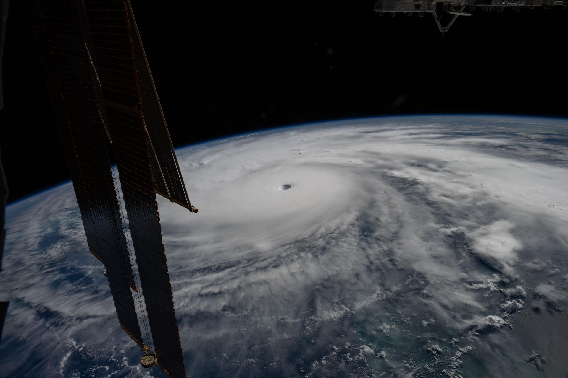
Hurricane Melissa is seen 50 miles south of Jamaica in this photograph taken from the International Space Station on Oct. 28, 2025.
NASA
Last November, NASA and its European partners launched the Sentinel-6B satellite to improve hurricane forecasts, help protect infrastructure, and benefit commercial industries, including shipping. The satellite now is flying 30 seconds behind its predecessor, Sentinel-6 Michael Freilich. Both satellites are providing precise sea level height measurements during what oceanographers expect to be a historic El Niño, a naturally occurring oceanic phenomenon in which warmer-than-usual Pacific waters shift global weather patterns.
The two satellites make up the Copernicus Sentinel-6/Jason-CS (Continuity of Service) mission, the latest in a series of ocean-observing radar altimetry missions that have been monitoring Earth’s changing seas continuously since the early 1990s.
The data each satellite is collecting will not only allow scientists to better understand this year’s El Niño but will also help them create more accurate hurricane predictions.
“This El Niño was a late-bloomer,” said Josh Willis, Sentinel-6B’s project scientist at NASA’s Jet Propulsion Laboratory in Southern California. “It didn’t kick off until the middle of the year and is just now reaching a strength similar to what we’ve seen in the satellite record during significant El Niños in 1997 and 2015. We expect it to be big, and it’s already having big impacts.”
El Niños generally scramble weather patterns tied to rainfall and storms, including hurricanes. They also redistribute heat in the ocean, which affects sea level. Normally, Earth’s warmest ocean waters sit along the equator in the western Pacific. During El Niño, weakened winds, which usually blow westward along the equator, result in heat spreading east toward South America. The change in ocean heat shifts hurricane activity from the Atlantic to the Pacific Ocean.
Predicting hurricane strength
On July 15, Sentinel-6B began delivering low-latency data to scientists that could be used for weather predictions. That data will take some time to work its way into the research models on which meteorologists and climate scientists rely, but when it does, those improved models could save lives.
Data from Sentinel-6 satellite missions feeds into hurricane tracking algorithms used by federal and state agencies. Those predictions can activate disaster response efforts, mobilizing resources ranging from sandbag placement to National Guard activation. They also can lead to evacuation orders that require quick but well-informed decisions about logistics at a local level. More severe events may require engaging larger organizations, such as the Federal Emergency Management Agency.
A tropical storm can take a week or more to become a hurricane and make its way to a coastline, but a hurricane can rapidly intensify in the 48 hours prior to landfall, leaving planners little time to prepare.
“Hurricanes have been known to speed up quickly at the last moment, so the window in which to decide what to do is short,” said Deirdre Byrne, an oceanographer and altimetry expert with the National Oceanic and Atmospheric Administration (NOAA). “The goal is to forecast how much and how rapidly intensification will happen so that officials can make the right calls.”
Each Sentinel-6 satellite measures ocean height, as well as the size of waves and marine wind speed, using a radar altimeter, which bounces thousands of radar pulses a second off the crests and troughs of waves. Ocean height varies from place to place and provides insight into the ocean’s heat content, since warm water expands. That, in turn, helps forecast how fast hurricanes will grow.
Among the measurements Sentinel-6 is gathering, Byrne is most anticipating the ocean height data, which she plans to begin incorporating into the current Satellite Ocean Heat Content Suite algorithm by the end of the year.
“In terms of data quality, the Sentinel-6 missions are unparalleled,” Byrne said.
Together, the missions are also extending a precise dataset deep into its fourth decade. This record of sea level observations traces back to the TOPEX/Poseidon mission, which launched in 1992, and continues through to the present day with Sentinel-6 Michael Freilich. Sentinel-6B will take over for its predecessor as the reference satellite for global sea level measurements later this year.
“The key is consistency, measuring the same way, every time,” said Severine Fournier, Sentinel-6B deputy project scientist, JPL. “That’s what lets us predict hurricanes, and, in turn, protect coastal communities and infrastructure.”
More about Sentinel-6B
Sentinel-6 Michael Freilich, named after a former director of NASA’s Earth Science Division, is one of two satellites that compose the Copernicus Sentinel-6/Jason-CS mission.
Sentinel-6/Jason-CS, a part of the European Union’s Earth observation program called Copernicus, was jointly developed by ESA (European Space Agency), EUMETSAT (European Organisation for the Exploitation of Meteorological Satellites), NASA, and NOAA, with funding support from the European Commission and technical support on performance from the French space agency CNES (Centre National d’Études Spatiales). Spacecraft monitoring and control, as well as the processing of all the altimeter science data, is carried out by EUMETSAT on behalf of the European Union’s Copernicus Programme, with the support of all partner agencies.
NASA JPL, a division of Caltech in Pasadena, contributed three science instruments for each Sentinel-6 satellite: the Advanced Microwave Radiometer, the GNSS-RO, and the Laser Retroreflector Array. NASA also contributed launch services, ground systems supporting operation of the agency’s science instruments, the science data processors for two of these instruments, and support for the United States members of the international Ocean Surface Topography Science Team.
Preparations for Next Moonwalk Simulations Underway (and Underwater)
Hurricane Melissa is seen 50 miles south of Jamaica in this photograph taken from the International Space Station on Oct. 28, 2025.
NASA
Last November, NASA and its European partners launched the Sentinel-6B satellite to improve hurricane forecasts, help protect infrastructure, and benefit commercial industries, including shipping. The satellite now is flying 30 seconds behind its predecessor, Sentinel-6 Michael Freilich. Both satellites are providing precise sea level height measurements during what oceanographers expect to be a historic El Niño, a naturally occurring oceanic phenomenon in which warmer-than-usual Pacific waters shift global weather patterns.
The two satellites make up the Copernicus Sentinel-6/Jason-CS (Continuity of Service) mission, the latest in a series of ocean-observing radar altimetry missions that have been monitoring Earth’s changing seas continuously since the early 1990s.
The data each satellite is collecting will not only allow scientists to better understand this year’s El Niño but will also help them create more accurate hurricane predictions.
“This El Niño was a late-bloomer,” said Josh Willis, Sentinel-6B’s project scientist at NASA’s Jet Propulsion Laboratory in Southern California. “It didn’t kick off until the middle of the year and is just now reaching a strength similar to what we’ve seen in the satellite record during significant El Niños in 1997 and 2015. We expect it to be big, and it’s already having big impacts.”
El Niños generally scramble weather patterns tied to rainfall and storms, including hurricanes. They also redistribute heat in the ocean, which affects sea level. Normally, Earth’s warmest ocean waters sit along the equator in the western Pacific. During El Niño, weakened winds, which usually blow westward along the equator, result in heat spreading east toward South America. The change in ocean heat shifts hurricane activity from the Atlantic to the Pacific Ocean.
Predicting hurricane strength
On July 15, Sentinel-6B began delivering low-latency data to scientists that could be used for weather predictions. That data will take some time to work its way into the research models on which meteorologists and climate scientists rely, but when it does, those improved models could save lives.
Data from Sentinel-6 satellite missions feeds into hurricane tracking algorithms used by federal and state agencies. Those predictions can activate disaster response efforts, mobilizing resources ranging from sandbag placement to National Guard activation. They also can lead to evacuation orders that require quick but well-informed decisions about logistics at a local level. More severe events may require engaging larger organizations, such as the Federal Emergency Management Agency.
A tropical storm can take a week or more to become a hurricane and make its way to a coastline, but a hurricane can rapidly intensify in the 48 hours prior to landfall, leaving planners little time to prepare.
“Hurricanes have been known to speed up quickly at the last moment, so the window in which to decide what to do is short,” said Deirdre Byrne, an oceanographer and altimetry expert with the National Oceanic and Atmospheric Administration (NOAA). “The goal is to forecast how much and how rapidly intensification will happen so that officials can make the right calls.”
Each Sentinel-6 satellite measures ocean height, as well as the size of waves and marine wind speed, using a radar altimeter, which bounces thousands of radar pulses a second off the crests and troughs of waves. Ocean height varies from place to place and provides insight into the ocean’s heat content, since warm water expands. That, in turn, helps forecast how fast hurricanes will grow.
Among the measurements Sentinel-6 is gathering, Byrne is most anticipating the ocean height data, which she plans to begin incorporating into the current Satellite Ocean Heat Content Suite algorithm by the end of the year.
“In terms of data quality, the Sentinel-6 missions are unparalleled,” Byrne said.
Together, the missions are also extending a precise dataset deep into its fourth decade. This record of sea level observations traces back to the TOPEX/Poseidon mission, which launched in 1992, and continues through to the present day with Sentinel-6 Michael Freilich. Sentinel-6B will take over for its predecessor as the reference satellite for global sea level measurements later this year.
“The key is consistency, measuring the same way, every time,” said Severine Fournier, Sentinel-6B deputy project scientist, JPL. “That’s what lets us predict hurricanes, and, in turn, protect coastal communities and infrastructure.”
More about Sentinel-6B
Sentinel-6 Michael Freilich, named after a former director of NASA’s Earth Science Division, is one of two satellites that compose the Copernicus Sentinel-6/Jason-CS mission.
Sentinel-6/Jason-CS, a part of the European Union’s Earth observation program called Copernicus, was jointly developed by ESA (European Space Agency), EUMETSAT (European Organisation for the Exploitation of Meteorological Satellites), NASA, and NOAA, with funding support from the European Commission and technical support on performance from the French space agency CNES (Centre National d’Études Spatiales). Spacecraft monitoring and control, as well as the processing of all the altimeter science data, is carried out by EUMETSAT on behalf of the European Union’s Copernicus Programme, with the support of all partner agencies.
NASA JPL, a division of Caltech in Pasadena, contributed three science instruments for each Sentinel-6 satellite: the Advanced Microwave Radiometer, the GNSS-RO, and the Laser Retroreflector Array. NASA also contributed launch services, ground systems supporting operation of the agency’s science instruments, the science data processors for two of these instruments, and support for the United States members of the international Ocean Surface Topography Science Team.
NASA’s Neil Gehrels Swift Observatory is back to studying the universe, even as the aging spacecraft continues to lose altitude and a planned mission to raise its orbit has been scaled back. Two of Swift’s three science instruments are operating again after months of conservation measures designed to reduce atmospheric drag and keep the observatory [...]
The discussion of communication communication technologies continues as the panel of Chuck Joiner, Jeff Gamet, and Marty Jencius make the jump from telegraphs and long-distance calls to texting, smartwatches, satellite connectivity, and possible implanted devices. How science fiction anticipated so many of today’s modern communications questions such as convenience, safety, privacy, tracking, and social change wrap […]
Welcome to this edition of The Intelligence Brief... This week, the United States, China, and other world powers are developing increasingly sophisticated military capabilities in space, raising concerns that Earth’s orbit could become a critical battlefield in future conflicts. In our analysis, we’ll be looking at 1) how China’s secretive Shenlong spaceplane and recent orbital maneuvers reveal Beijing’s growing counterspace capabilities, 2) how the U.S. and its allies are responding as spacecraft increasingly demonstrate “dogfighting,” rendezvous, and other potentially military operations, 3) why Russia’s longstanding pursuit of anti-satellite weapons—including potentially nuclear-armed orbital systems—adds another dimension to the emerging threat, and 4) how growing military dependence on satellites could create dangerous new vulnerabilities and pathways for escalation between nuclear-armed powers.
Quote of the Week
“We must be well-prepared for conflict in space. And if deterrence fails, we will fight and win.”
– US Space Command chief General Stephen Whiting
If you enjoy the news and perspectives offered by The Debrief, make sure that you aren’t missing our stories by making us one of your “preferred sources” on Google News. You can simply follow this link to add The Debrief to your list of favorites, and you can read more about Google’s preferred sources in our article here.
Get all the latest stories from The Debrief, with more breaking stories at the end of this week’s newsletter.
U.S. and China Are Preparing for a New Kind of Warfare in Space
Military competition between the U.S. and China is ramping up, according to new developments that showcase how both nations are developing maneuverable spacecraft, counterspace weapons, and other technologies with the potential to shape the orbital battlefield of tomorrow.
The developments, first reported by Reuters, involve the revelation that China’s secretive uncrewed spaceplane had released a small satellite in orbit earlier this year, activity which was detected and analyzed by LeoLabs. According to the company’s analysis, the object released by the Chinese spaceplane was reportedly observed maneuvering around another Chinese satellite before returning to the spaceplane.
Launched from the Jiuquan Satellite Launch Center in the vast Gobi Desert, China’s spaceplane, known as Shenlong—a name meaning “Divine Dragon”—took flight on its current mission in February. With the new confirmation of an orbital test based on LeoLabs data, the recent developments offer a clear demonstration of the increasingly sophisticated operations China is capable of conducting in orbit.
The U.S. and China’s “Arms Race” for Space
Of course, the United States also has its own secretive reusable spaceplane—the Boeing X-37B—and similarities between the two spacecraft have drawn notable comparisons in the past. Although much about its missions remains undisclosed, the X-37B serves as an orbital test platform for experimental technologies, while the U.S. Space Force is developing both defensive and offensive capabilities intended to protect American interests in space and counter potential adversaries.
“The Chinese are rapidly developing capabilities,” including ground- and space-based weapons designed to interfere with or destroy targets, U.S. Space Force Chief of Space Operations Gen. Chance Saltzman said in July, describing the threat as “substantial.”
Examples of what U.S. officials have characterized as orbital “dogfighting” have already been demonstrated by China, which includes incidents where multiple spacecraft reportedly maneuvered in close proximity, along with the apparent capture and relocation of defunct satellites. Orbital refueling capabilities are also believed to be in development that could significantly extend the operational lives of such spacecraft and their related orbital technologies.
In response to the Chinese demonstrations, the U.S. and other nations have engaged in similar efforts, which include an American military satellite that maneuvered near a British spacecraft last September as China’s Shiyan 12-01 experimental satellite passed roughly 83 kilometers below, an operation several experts interpreted as a demonstration of allied capabilities.
While such technologies also have legitimate civilian applications in many cases, the potential for their military use is becoming harder to ignore, and U.S. officials have warned that adversaries could attempt to target American space systems early in a future conflict—and China is by no means the only foreign adversary nation engaged in the development of such technologies.
Warfare in Earth’s Orbit
In August, a research article funded by the Russia Strategic Initiative, U.S. European Command, examined Russia’s pursuit of anti-satellite weapons, which have deep roots in Soviet nuclear strategy. Such decades-old efforts focused on disabling U.S. satellites, which were viewed as a potential means of disrupting early warning, communications, and command-and-control systems during a major conflict.
Today, such Cold War-era concerns have resurfaced, as Russian military thinking has expanded to include more destructive counterspace capabilities, which may include nuclear-armed orbital systems designed to disable large numbers of satellites at once. This raises the prospect that Moscow could attempt to effectively take low-Earth orbit offline should a major conflict occur, thereby disabling critical communications systems relied on by the U.S. and other nations.
Concerns over such capabilities apparently aren’t mere speculation. In 2024, the Pentagon revealed that Russia had launched a satellite it assessed was likely a counter-space weapon, believed to be capable of attacking and disabling other satellites in low-Earth orbit.
Space Warfare and the Changing Geopolitical Landscape
The broader challenge facing the United States and its allies is that space has become indispensable to modern warfare, while also simultaneously becoming increasingly vulnerable to attack.
Western militaries are heavily reliant on satellites for communications systems, as well as GPS navigation, missile warning, precision targeting, intelligence gathering, and a range of other capabilities. Equally problematic is that many civilian and commercial systems rely on the same orbital infrastructure.
Right now, Russia and China are believed to be developing counterspace capabilities ranging from electronic jamming, cyberattacks, and directed-energy systems to anti-satellite missiles and maneuverable spacecraft capable of approaching other satellites.
Fundamentally, this creates a difficult issue in terms of deterrence, since an adversary might disrupt a critical satellite without physically destroying it, making attribution and determining an appropriate military response far more complicated than simply responding to a conventional attack. Further, the ongoing integration of commercial systems with military operations may increase the likelihood of attacks that could target non-military targets.
Altogether, the emerging picture is more than just one involving whether the next major war could extend into Earth’s orbit: it is a question of how, and to what extent, future attacks on spacecraft by adversary nations could affect events back on Earth, and what the longer-term implications could be for communications, navigation, and other capabilities upon which civilians increasingly rely—all while creating new pathways for escalation between nuclear-armed world powers.
The Secret History of the Nancy Grace Roman Space Telescope
The clandestine side of the Roman telescope’s story begins in 2012, with a surprise that landed on NASA’s doorstep at the agency’s Goddard Space Flight Center: a pair of once-classified spy satellites.
The Roman Telescope is a modified version of one of those two former spy satellites NASA received in 2012, which were originally developed for looking back toward Earth, rather than scouring the cosmos for signs of exoplanets and signs of some of the universe’s most elusive phenomena.
However, the original NRO project that led to the development of its satellites ended up being cancelled due to budgetary issues. So as not to allow the technology to go to waste, the orphaned satellites were soon handed over to NASA.
Retrofitting a Spy Satellite for Space Observations
Before the new Roman telescope that has astronomers so excited would take shape, NASA had to take the existing satellite frames provided by the NRO and attach special instruments that would equip it for cosmic observations, rather than just the clandestine ones it was originally designed for with its observations of Earth.
These additions included an infrared camera similar to the one on NASA’s James Webb Space Telescope (JWST), which allows it to observe phenomena at infrared wavelengths and spot phenomena across great cosmic distances that may not be discernible from Earth at normal visible wavelengths.
Along with the addition of new instruments, the satellite was also fitted for deployment further from Earth at the same Lagrange Point currently occupied by Webb.
Overcoming Obstacles
The telescope is named after Nancy Roman, NASA’s first female executive, who served as its first chief of astronomy and was an influential astronomer in the development of classifications for stellar objects and their motion.
Even with its original development by another government agency, the Roman Telescope’s mission was nearly cancelled because of proposals in 2018 and 2019 under the first Trump administration.
Fortunately, with its launch scheduled for Sunday morning, Roman has already overcome several hurdles on its way from its original development for one of America’s spy agencies to becoming NASA’s newest milestone in astrophysics studies.
Micah Hanks is the Editor-in-Chief and Co-Founder of The Debrief. A longtime reporter on science, defense, and technology with a focus on space and astronomy, he can be reached atmicah@thedebrief.org. Follow him on X @MicahHanks, and at micahhanks.com.
Un étage supérieur de Falcon 9 s'est retrouvé sur une trajectoire de collision avec la Lune. Si nous n’avons aucune image du moment de l’impact, un satellite coréen a pu prendre les premières images du cratère.
Depuis vingt-cinq ans, Futura raconte les grandes avancées scientifiques qui changent notre compréhension du monde. Parmi elles, une mission spatiale discrète a profondément transformé les sciences de la Terre. En « pesant » notre Planète depuis l'espace, les satellites Grace ont apporté dès...
HELSINKI — China sent a new pair of secretive satellites into a programmatically new orbit Wednesday, while also upgrading its on-orbit communications relay capabilities. A Long March 6A rocket lifted […]
En Gironde et dans les Landes, un feu né à Saumos a déjà dévoré plus de 42 000 hectares. Il a dépassé le bassin d’Arcachon et léché la métropole bordelaise. Ces quelques images replacent ces feux de 2026 dans l’histoire récente de la France… et face aux mégafeux qui pulvérisent nos records.
Un internaute a découvert qu’un satellite de télécommunication Starlink de SpaceX est passé devant un satellite d’imagerie de la surface Terre pendant qu’il survolait le Texas. L’image a été retrouvée sur Google Earth. Que nous dit cet événement pas si anodin que cela ?
Emergency SOS via satellite is now available in Andorra and Iceland, allowing supported iPhone and Apple Watch users to contact emergency services when cellular and Wi-Fi coverage are unavailable.
Apple added both countries to an updated support document, expanding the feature to 20 supported markets. Users in Andorra and Iceland can call or text 112 before choosing the satellite option when an ordinary emergency connection cannot be completed.
The expansion covers every iPhone 14 or later model running iOS 26.4 or newer. Apple Watch access requires Apple Watch Ultra 3 with watchOS 26.4 or later.
Emergency SOS does not turn the devices into conventional satellite phones. The system is designed for short emergency exchanges in locations where normal communication networks cannot be reached. Users must remain outdoors with a sufficiently clear view of the sky and follow onscreen directions while the device establishes and maintains a connection.
Emergency SOS via Satellite Reaches 20 Markets
Emergency SOS via satellite first launched in the United States and Canada in November 2022 with the iPhone 14 lineup. Apple gradually added European countries, Australia, New Zealand, Japan and Mexico as regulatory approval and emergency-service support became available.
Andorra and Iceland now join Australia, Austria, Belgium, Canada, France, Germany, Ireland, Italy, Japan, Luxembourg, Mexico, the Netherlands, New Zealand, Portugal, Spain, Switzerland, the United Kingdom and the United States.
The addition is particularly relevant for travelers and residents exploring mountainous or remote terrain.
Andorra contains extensive hiking, cycling and skiing areas across the Pyrenees, where cellular coverage can become unreliable beyond populated valleys and resorts. Iceland presents a different but equally demanding environment, with large rural areas, volcanic landscapes, glaciers and routes far from conventional infrastructure.
Satellite availability does not guarantee a connection everywhere. Mountains, deep valleys, dense tree cover and tall structures can obstruct the line between the device and a passing satellite. Apple also warns that satellite connectivity may not function in locations above 62 degrees latitude, which can affect some northern regions.
Most of Iceland lies below that threshold, although environmental conditions and the position of surrounding terrain can still influence performance.
International travelers can generally use Emergency SOS while visiting a supported country, even when the feature is not offered in their home market. Exceptions apply to devices purchased in certain countries or regions where Apple satellite connectivity is restricted.
iPhone 14 and Newer Models Gain the Expansion
Every version of iPhone 14 and later contains the hardware required for Apple satellite features. Users in Andorra and Iceland must install iOS 26.4 or a newer release before relying on Emergency SOS.
The system appears only when the iPhone cannot reach cellular service or Wi-Fi. Apple recommends trying the local emergency number first because another carrier network may still be able to complete the call even when the user own provider shows no coverage.
When the call fails, the iPhone offers Emergency Text via Satellite. The user answers a short series of questions describing the emergency, including the type of assistance needed and whether anyone is injured.
The compressed questionnaire reduces the amount of information that must be transmitted through the limited-bandwidth satellite connection. Once connected, the iPhone sends the responses and location to an emergency dispatcher or an Apple-supported relay center capable of contacting local responders.
In Andorra and Iceland, the applicable emergency number is 112.
Users can also choose to notify emergency contacts. When Medical ID and emergency contacts have been configured in the Health app, selected details can be shared during the incident.
The conversation does not operate at the speed of an ordinary text exchange. Under ideal conditions, a message may require approximately 30 seconds to send. Light or moderate foliage can extend that delay beyond one minute, while heavier obstructions may prevent a connection entirely.
The iPhone displays guidance showing which direction to turn or move as satellites pass overhead. The phone can remain connected while the screen is locked, but it should not be placed inside a pocket or backpack during the exchange.
Apple Watch Ultra 3 Works Without an iPhone Nearby
Apple Watch Ultra 3 brings similar protection directly to the wrist, allowing users to contact emergency services even when an iPhone is not available.
Emergency SOS via satellite on Apple Watch Ultra 3 does not require an active carrier plan. Apple includes the service at no additional charge for two years following activation of the watch.
When cellular and Wi-Fi connections are unavailable, users can attempt an emergency call or open Messages and text 112. If the message cannot be delivered through an ordinary network, the watch presents the satellite emergency option.
Apple Watch Ultra 3 also guides the wearer toward the satellite connection. The device can remain in its normal position on the wrist rather than being held above the head, although the user may be instructed to turn or move away from an obstruction.
A wet watch may have more difficulty maintaining satellite communication, an important limitation for swimmers, boaters and users caught in severe weather.
The watch can send the emergency questionnaire, location, elevation, Medical ID information and battery level. Emergency contacts can also receive information about the incident when the user has enabled that option beforehand.
Crash Detection and Fall Detection add another layer. If iPhone 14 or later or Apple Watch Ultra 3 detects a severe crash or hard fall and the user remains unresponsive, the emergency notification may be transmitted over satellite when cellular and Wi-Fi networks are unavailable.
Image Credit: Apple Inc.
Preparation Matters Before Going Off-Grid
Apple provides a connection demonstration that allows users to practice finding a satellite without contacting emergency services.
On iPhone, the demonstration can be opened through the Satellite controls or the Emergency SOS section in Settings. Apple Watch Ultra 3 users can add the Satellite control to Control Center or place a satellite complication on the watch face.
Testing the process before a remote trip helps users understand how quickly conditions can affect the connection. A clear field may establish contact rapidly, while a canyon or heavily wooded trail may require movement toward more open terrain.
Medical ID and emergency contacts should also be completed before leaving network coverage:
Health > Profile > Medical ID
A Medical ID can provide responders with information such as allergies, medical conditions, medications and emergency contacts. Users remain responsible for deciding which personal details they want stored and shared.
Emergency SOS via satellite is included free for two years after activating an iPhone 14 or newer model. Apple provides the same two-year period with Apple Watch Ultra 3, although the company has not established the long-term price that may apply after promotional access ends.
The arrival in Andorra and Iceland gives hikers, drivers, skiers and other travelers another route to help, but the safest preparation still includes checking weather conditions, sharing an itinerary and carrying adequate power before moving beyond ordinary network coverage.
Les flammes sont visibles à des kilomètres. Mais vus du ciel, les incendies de Gironde et des Landes révèlent une autre réalité. Satellites et radars météorologiques montrent des phénomènes invisibles à l’œil nu qui disent toute la violence des feux.

 Login