❌

Normal view

β€œI Couldn’t Do It Anymore” – Antarctic Guides Quit Their Dream Jobs After Witnessing Tourism’s Damage

Snowfall Frozen Tourists AntarcticaAntarctic guides walked away from their dream jobs after tourism’s environmental damage became impossible to ignore. β€œYou’d see massive glacier calvings, and you’d just want to cry. But all the guests would be cheering. And you’d be like … β€˜Can you not put two and two together?’” Those are the words of a former Antarctic [...]

Microbial DNA hidden under Antarctica offers new clues about how the continent’s mysterious Blood Falls came to be

At the end of a glacier deep in East Antarctica's Taylor Valley, there is a haunting waterfall that oozes red brine like a bleeding wound in the ice. Scientists explained the brine's gory hue several years ago, finding that it is exceptionally rich in iron. And now, they may have identified the salty water's origin.

Microbes in the crimson waterfall, called Blood Falls, suggest the brine is composed of ancient seawater that was trapped in a pool beneath the glacier when ocean levels fell and the glacier advanced. However, it's unclear exactly when that happened, researchers noted. Previous studies had already proposed a seawater origin for the brine, based on various chemical signatures and bacteria detected in the liquid, but the new results add molecular and genetic evidence to the mix of clues.

"Findings in this study reveal a dominance of marine eukaryotic lineages in the Blood Falls area" compared with the broader region, known as the McMurdo Dry Valleys, the authors wrote in the study, published Monday (Aug. 3) in the journal Nature Geoscience. "This marine signal is less prominent but still detectable in the prokaryotic structure," the researchers added.

Eukaryotes' cells contain a membrane-bound nucleus and other closed internal compartments. Prokaryotes, by contrast, are single-celled organisms whose DNA floats around freely in the cell, unbounded by a membrane.

To characterize the types of microorganisms present within Blood Falls, the researchers used a suite of genetic techniques to analyze 167 samples of water, sediment and air from around the falls and the broader McMurdo Dry Valleys.

Some researchers argue that Blood Falls' water does not originate from seawater, and suggest the marine bacteria and chemical signatures that point to seawater may have instead reached the falls from the ocean via intense winds, which are common in the McMurdo Dry Valleys. By analyzing samples from various sites in the Dry Valleys, the team behind the new study compared microorganisms from the wider region with those at Blood Falls to determine if Blood Falls has a distinct microbial assemblage potentially left over from ancient conditions.

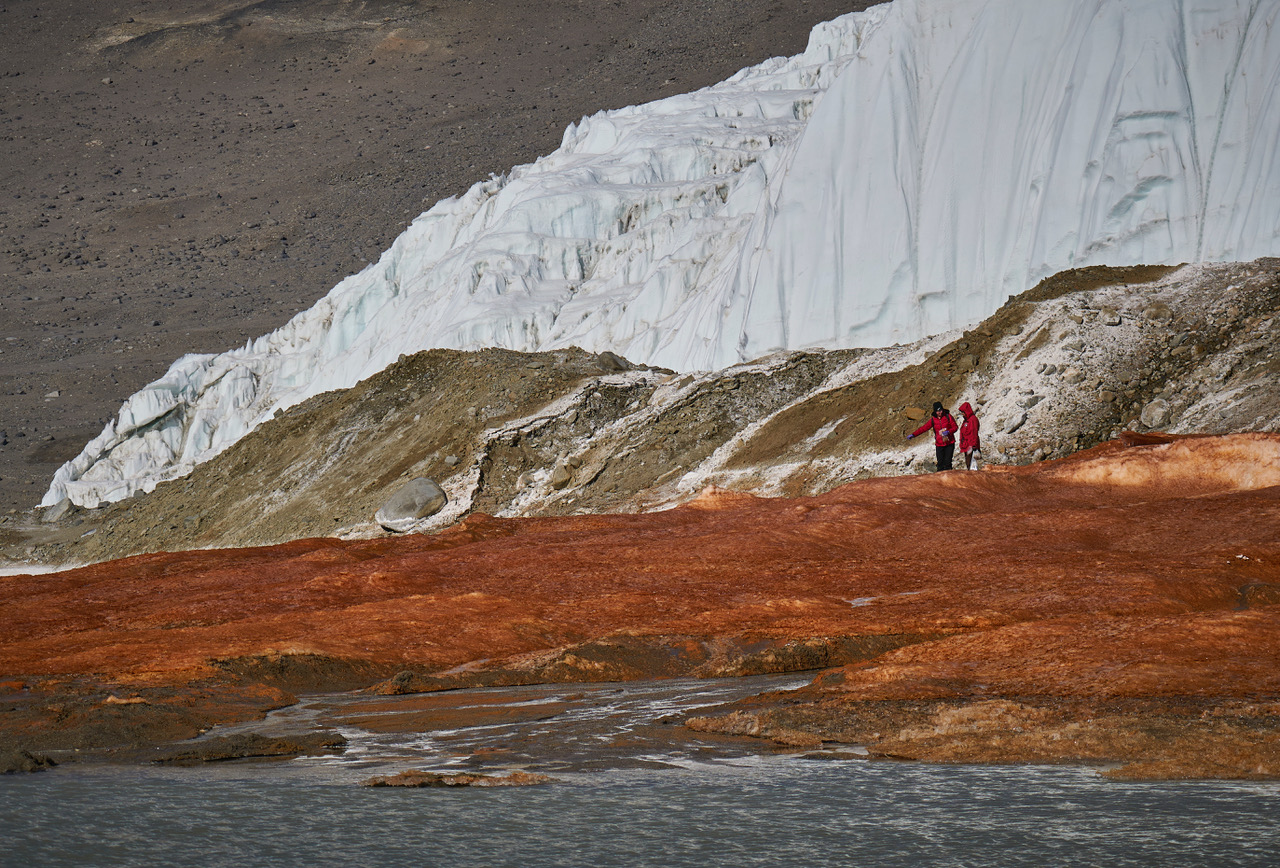
The researchers found that the crimson brine and associated red-tinted sediments at Blood Falls shared a higher proportion of eukaryotes with nearby oceanic samples than other sites in the Dry Valleys did. Whereas Blood Falls had a little over 9% of its eukaryotes in common with the ocean, the Dry Valleys showed only about 1% similarity, according to the study. The remaining eukaryotes and most of the prokaryotes identified in the paper had freshwater and terrestrial origins.

Two researchers stand on red-stained sediments near Blood Falls in Antarctica.

Researchers tried to determine if microbes at Blood Falls are distinct community from the surrounding region's assemblages. (Image credit: Bryan Minnea)

The results also showed that the air near Blood Falls contained only a tiny proportion of marine microorganisms, suggesting that present-day winds can't fully explain the microbial composition of Blood Falls, the researchers wrote.

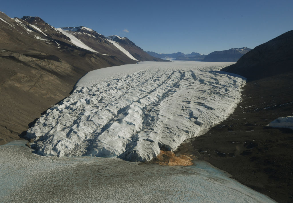
Aerial view of Taylor Glacier and Blood Falls in Antarctica.

The most likely origin for the brine that feeds Blood Falls is ancient seawater that was trapped when sea levels dropped and the Taylor Glacier advanced, the study found. (Image credit: MARK RALSTON/POOL/AFP via Getty Images)

Therefore, an ancient seawater origin is the most likely explanation for the microorganisms found at Blood Falls today, the team concluded. Winds may have played a role in shaping the community in the past, but now, their influence is probably insignificant, the team added.

The brine that feeds Blood Falls may have become entrapped more than 1 million years ago, during a warm period with higher sea levels and less ice cover than there is now, previous estimates suggested. However, further work, including more comprehensive genetic profiling and mapping of microorganisms, is needed to pinpoint when Taylor Valley's glacier grew to cover the brine, the researchers wrote.

Antarctica quiz: Test your knowledge on Earth's frozen continent

Antarctica just experienced minus 119 F, Earth's coldest temperature since 2012 β€” here's why

29 July 2026 at 19:54

While millions around the world grappled with extreme heat this month, a research station in Antarctica recorded Earth's coldest temperature since 2012.

The high-altitude research station, named Concordia, logged a low of minus 119.4 degrees Fahrenheit (minus 84.1 degrees Celsius) on July 18, according to data from the station.

Concordia is located in the interior of the Antarctic continent, which is currently in the dead of winter with no sunlight. Temperatures at the station regularly fall below minus 112 F (minus 80 C) this time of year β€ͺ—‬ so the new reading isn't unprecedented, but it's still significant.

"Even here, where extreme cold is expected, temperatures below minus 84 C are remarkable and highlight how variable Antarctic weather can still be," Gabriele Carugati, the station leader at Concordia for Italy's National Antarctic Research Program (PNRA), told Live Science over a video call from the station.

The French Polar Institute Paul-Γ‰mile Victor, which runs Concordia with the PNRA, sent Live Science raw data from July 18, which showed the temperature dropping to minus 84.1 C twice, at 6:25 a.m. and 6:34 a.m. local time.

The extreme chill at Concordia stands in sharp contrast to the sweltering heat that many countries are currently experiencing. North America and Europe have been battling heat waves this summer, with Western Europe recording the hottest June on record. Meanwhile, wildfires are raging in Canada, the U.S., France, Spain and other countries.

Globally, average temperatures are going up as humans pump more heat-trapping greenhouse gases into the atmosphere. However, Earth's weather systems are complex, and climate change doesn't mean that everywhere gets hotter all of the time.

"Climate change describes the long-term global trends, while individual weather events can still [bring] exceptional cold," Carugati said. "Antarctica is influenced by complex atmospheric processes, so an extreme low temperature at one location does not contradict the broader picture of global warming."

"Astronauts of ice"

Concordia is considered the most remote and extreme research station in the world. Built on top of a 10,800-foot-thick (3,300 meters) ice cap, the station is used for a variety of purposes, including seismic observations, astronomy and the modeling of Earth's past climates, according to the French Polar Institute Paul-Γ‰mile Victor.

"Concordia is a special place because it sits at over 3,200 meters [10,500 feet] above sea level on the Antarctic Plateau, and more than 1,000 kilometers [600 miles] from the coast," Carugati said. "During winter, there is no sunlight for months, the atmosphere is extremely dry and stable, and under clear skies, heat continuously escapes to space because there are no clouds, allowing temperatures to fall to extraordinary levels."

Concordia's environment is so harsh and isolated that the station is also used to improve our understanding of the physical, mental and social challenges astronauts experience in space. Carugati noted that the only person at the station who is not researching the environment is a European Space Agency biomedical doctor, who is studying the researchers who work there, nicknamed "astronauts of ice."

Planes can't fly to Concordia once winter sets in, and it's around 370 miles (600 kilometers) from the nearest research station. That technically makes crews more isolated than astronauts on the International Space Station, which orbits about 250 miles (400 km) above Earth, according to the European Space Agency.

What is the coldest temperature ever recorded?

The coldest temperature ever recorded at Concordia was minus 120.5 F (minus 84.7 C), logged in the winter of 2010, according to the Italian Antarctic Meteo-Climatological Observatory. However, another high-altitude research station in East Antarctica has the all-time record for the coldest temperature ever recorded on Earth. Russia's Vostok weather station, the nearest station to Concordia, recorded a temp of minus 128.6 F (minus 89.2 C) in July 1983, according to the World Meteorological Organization.

Satellite data suggests that temperatures can drop as low as minus 144 F (98 C) in East Antarctica, according to a 2018 study published in the journal Geophysical Research Letters. However, even though Antarctica is the coldest and driest continent, it's not immune to global warming.

Major glaciers and the ice sheet they support are at risk in West Antarctica, with the Antarctic Peninsula β€” which extends out of the western side of the continent β€” experiencing the most rapid warming. A study published in February in the journal Frontiers in Environmental Science found that decisions made on greenhouse gas emissions today will determine how much the peninsula will change in the coming centuries, with sea ice, ice shelves and glaciers, along with the penguins that live on them, at risk of disappearing.

Concordia sits on the largest ice sheet on Earth. This sheet in East Antarctica is more stable than the smaller sheet of West Antarctica, but it is still vulnerable to rising temperatures. An unprecedented Antarctic winter heat wave in March 2024 saw temperatures near Concordia rise to a record high of 15.1 F (minus 9.4 C) β€ͺ—‬ about 32 F (18 C) warmer than the previous March maximum. This East Antarctic heat wave was amplified by global warming, according to a study published in April in the journal npj Climate and Atmospheric Science.

Earth recently entered an El NiΓ±o, the warm phase of a multiyear natural climate pattern, which could bring unprecedented temperature extremes to an already-warming world. Carbon Brief, a U.K. based outlet that reports on climate news and policy, has predicted that 2026 is likely to be the second-warmest year on record, behind 2024, with the intensifying El NiΓ±o increasing the likelihood that 2027 will be the warmest year ever recorded.

For now, at Concordia, the researchers are continuing their work in the blistering cold of Antarctica's winter. Carugati noted that the latest extreme-temperature data will inform forecasts and long-term climate monitoring.

"Extreme observations like this help scientists better understand atmospheric processes and improve the climate models," he said.

Antarctica’s Unusual Islands, 5,000-Year-Old β€˜Sophisticated’ Egyptian Technology, and a 1.4-Million-Year-Old Fossil Surprise

28 July 2026 at 15:59
Egypt
(Image Credit: Egyptian Ministry of Tourism and Antiquities)

This week in stories we’re covering atΒ The Debrief… Recent NASA satellite imagery has revealed something odd about the color of Antarctica’s Danger Islandsβ€”and what that means for one of Earth’s most fragile ecosystems. Elsewhere, a 5,000-year-old Egyptian tomb discovery has revealed β€œsophisticated” knowledge that challenges past thinking on the origins of the pyramids. And lastly, scientists were recently very surprised when they learned what left these 1.4-million-year-old fossilized footprints on an ancient lakeshore.

Here are the top stories we’re covering right now:

Satellite Images Revealed Something Unusual About the Color of These Antarctic Islandsβ€”Here’s the Odd Reason Behind Their Appearance

28 July 2026 at 15:42

Seen from space, the Danger Islands along Antarctica’s rocky coastline have a distinctive pink-orange coloration, with tiny trails of pink closer to its shorelines.

However, the unique colors of these islands aren’t attributable to minerals, colorful lichens, or other kinds of usual causes. According to NASA, the Danger Islands look the way they do because of their iconic residents.

Now, data about the influence these creatures have on their surrounding habitat his helping scientists monitor the health of an entire Antarctic ecosystem from space.

A Colorful Surprise Spotted from Space

According to a new study’s findings, the vast colonies of AdΓ©lie penguins on the Danger Islands are the culprit behind their coloration. More specifically, it is the guano these flightless birds produce that has permanently altered their coloration when seen from space, resulting in pink stains along the shoreline environments where these waddling creatures reside.

Surprisingly, the guano stains offer an effective means of tracking the diets of these birds, which can serve as a good proxy for the broader changes occurring in Antarctica’s marine environment.

NASA Danger Islands
NASA image based on Landsat satellite imagery by Michala Garrison, showing pink guano stains along the coastlines of Heroina and Beagle Island (Image Credit: USGS/NASA Earth Observatory/Michala Garrison).

Primarily, this is because these large penguin colonies can deposit enough guano that their presence is detectable in satellite imagery, as is revealed in Landsat satellite imagery collected since the mid 1980s. The distinctive pinkish hue observed on the Danger Islands today indicates a diet rich in krill, whereas eating more fish would produce very different color signaturesβ€”all of which can be detected through satellite observations.

Decades of Penguin Activity Revealed

For the new research, scientist Casey Youngflesh with the Department of Biological Sciences at Clemson University, along with her coauthors, analyzed more than three decades of Landsat satellite imagery collected from 1984 through 2013.

These observations, combined with samples collected from field studies involving penguin colonies, helped the researchers establish links between specific color patterns and the balance of krill and fish in the birds’ diets.

Among the team’s findings, the data revealed a very close relationship between penguin food sources and the extent of sea ice in the surrounding area, particularly during the breeding season of these shore-dwelling birds.

penguins
In the drone image above, a colony of penguins can be seen in two large circular groups along Antarctica’s coastline (Image Credit: Thomas Sayre-McCord/WHOI/MIT)

Colonies of penguins along the warmer Antarctic Peninsula and West Antarcticaβ€”locations where there is less sea iceβ€”revealed a greater reliance on krill. By contrast, Eastern Antarctic penguins consumed more fish in areas where sea ice persisted for longer. This higher-quality food source is also linked to improved chick growth and a greater degree of overall population success in the long term.

β€œSea ice is such a hugely important factor in the Antarctic marine environment,” said Youngflesh. β€œThe structure of the region’s food web is changing in response.”

The Future of Antarctic Environments

Along with what the team’s findings reveal about the lives and sustenance patterns of penguins, they also bring to mind several questions about the future of their habitat.

Although sea ice in Antarctica was found to be primarily stable during the years Youngflesh and her team examined, since 2013 it has shrunken significantly, reaching record low levels. Further declines are expected in the decades ahead, signaling changes that could push AdΓ©lie penguins toward increasingly krill-dependent diets.

This could become complicated as commercial krill fishing has seen expansion in recent years, and recovering populations of whales and seals are also competing for the same food source.

Right now, researchers are working to produce new computer models based on data obtained from the Landsat 8 and Landsat 9 satellites, which will help them continue to observe penguin diets from orbit. This data provides an unusualβ€”but also a remarkably effectiveβ€”means of monitoring the changing health of Antarctica’s fragile ecosystem.

The findings were reported in a new study, β€œSpace-based monitoring of penguin diet links sea ice, food webs, and population change,” which appeared in the journal Current Biology on July 20, 2026.

Micah Hanks is the Editor-in-Chief and Co-Founder of The Debrief. A longtime reporter on science, defense, and technology with a focus on space and astronomy, he can be reached atΒ micah@thedebrief.org. Follow him on XΒ @MicahHanks, and atΒ micahhanks.com.

Scientists Solve the Mystery of Why Antarctica Froze Before the Arctic

16 July 2026 at 12:04
Antarctica CoastlineAntarctica’s first ice sheet may have begun with a geological head start hidden deep beneath the continent. Millions of years before thick ice spread across the Northern Hemisphere, forces inside Earth lifted East Antarctica into a vast region of mountains and plateaus. The higher terrain became cold enough to preserve snow even when the planet [...]

Antarctica’s Future May Be More Predictable Than Scientists Thought

22 June 2026 at 22:58
Vanderford GlacierA new study suggests Antarctic ice loss may be reliably projected over the next several decades. Scientists say the next 30 to 50 years could be a crucial period for understanding and preparing for Antarctic ice loss and its impact on rising sea levels. A new study published in Nature and led by Monash University [...]

A Texas-size chunk of winter sea ice is missing from Antarctica β€” and it's probably not coming back

16 June 2026 at 17:39

A colossal chunk of sea ice roughly the size of Texas is missing from the west coast of Antarctica, and scientists fear it might never form again.

Antarctica is currently in winter, which runs from March to October on the southernmost continent. During the winter months, floating sea ice surrounding the continent typically grows, driving currents that regulate Earth's climate. But this year, there's a notable ice gap over the Bellingshausen Sea, on the western side of the Antarctic Peninsula.

Satellite observations have revealed that around 250,000 square miles (650,000 square kilometers) of sea ice hasn't formed yet, compared with the average amount of sea ice between 1991 and 2020, The Guardian reported last week. For comparison, the ice gap covers an area slightly larger than France or nearly the size of Texas.

Will Hobbs, a sea ice-ocean interaction scientist at the University of Tasmania, told The Guardian that he was "concerned" by the lack of sea ice and that it was "depressing." Hobbs noted that this year represents the third time in four years that the region's sea has been very low.

"I don't think we will see sea ice there any more," he said. "It's done."

Researchers still have a lot to learn about sea ice changes in Antarctica. Hobbs said that the sea ice loss was likely linked to changes in the ocean and that scientists are trying to determine whether global warming was a factor.

Sea ice has declined much more slowly in Antarctica than in the Arctic. But in recent years, scientists have been witnessing an astonishing change in the sea ice extent. One record low in 2016 was followed by another in 2022 and then a third in 2023.

Edward Doddridge, a physical oceanographer at the Institute for Marine and Antarctic Studies in Australia, told ABC News (Australia) that he was no longer surprised by sea ice loss.

"It's not good news, but it has become a pattern that we're expecting now," Doddridge said. "A warming world is going to have less sea ice."

The diminished winter sea ice is likely to have a variety of knock-on effects. For example, this area of sea ice normally provides important habitat for animals like krill and penguins. Sea ice also plays an important role in regulating the climate, including by driving key ocean currents, insulating the ocean from the sun, and protecting ice shelves at the mouths of glaciers.

Down the coast from the missing sea ice, researchers have warned that a key ice shelf is about to disintegrate from Antarctica's Thwaites Glacier β€” nicknamed the "Doomsday Glacier" because its collapse could raise sea levels by 2.1 feet (65 centimeters) in the coming centuries, flooding coastal communities worldwide. The ice shelf helps protect the mouth of the glacier by acting as a buttress, thereby restraining the flow of ice from the glacier into the sea.

Thwaites Glacier has been melting rapidly since the 1980s, which is part of a wider concern for the West Antarctic Ice Sheet that it helps to support. The collapse of such an ice sheet is considered one of the major environmental tipping points, or "points of no return," that humanity must avoid in the fight to rein in climate change.

Scientists Reveal What Happened When 12 People Were Trapped Together in Antarctica for 10 Months

12 June 2026 at 15:44
Tension Doctors Arguing Fighting ConflictA study at one of Earth’s most isolated research stations offers new clues about how teams adapt during long periods of confinement. When people are isolated in extreme environments, it seems intuitive that spending more time together would strengthen social bonds. But new research suggests that under the right conditions, constant contact may actually create [...]

Vast Hidden Structure Discovered Under Miles of Ice in East Antarctica

11 June 2026 at 11:34
EAFBP East AntarcticaScientists have discovered a colossal hidden structure beneath Antarctica that could reshape our understanding of the continent’s past and present. Scientists have identified a massive hidden geological formation beneath East Antarctica, revealing a continent-scale structure buried under some of the thickest ice on Earth. The discovery was made by an international team of researchers that [...]

Geoscientists Find Vast Fan-Shaped Structure beneath Antarctica’s Ice

8 June 2026 at 16:17
Fault-controlled basins and interpreted structural frame in the newly-identified East Antarctic Fan-Shaped Basin Province. Image credit: Armadillo et al., doi: 10.1038/s41561-026-01991-6.

By combining seismic, gravity and topographic data, a team of researchers from Italy, Switzerland, Germany and the United Kingdom found that several well-known subglacial basins in East Antarctica are part of a single fan-shaped province whose origins trace back to ancient continental stretching.

The post Geoscientists Find Vast Fan-Shaped Structure beneath Antarctica’s Ice appeared first on Sci.News: Breaking Science News.

The 'Doomsday Glacier' is poised to lose its ice shelf this year. An Antarctic researcher explains what that means for global sea levels

28 May 2026 at 09:04
Researchers have warned that the Thwaites Glacier, one of the largest glaciers in the world, is about to lose its eastern ice shelf. We spoke to marine geophysicist Robert Larter about what this means for the "Doomsday Glacier."

❌