❌

Normal view

Green Empire Strikes Back

2 August 2026 at 15:00

Just when it looked like Net Zero sceptics were winning the argument, the green lobby hit back. But David Turver says scratch beneath the headlines and the data simply doesn't stack up.

The post Green Empire Strikes Back appeared first on The Daily Sceptic.

EAGLE

31 July 2026 at 23:02

EAGLE

Explorer for Artemis Geology, Lunar, and Earth — a NASA satellite program to study surface biology and geology on Earth, with technologies that could support future missions to the Moon and Mars.

Future Mission

NASA’s EAGLE program — Explorer for Artemis Geology, Lunar, and Earth — will be a series of satellite missions studying surface properties using technologies for Earth observation that will also benefit future missions to the Moon and Mars, where they could identify critical resources and safe landing sites.

The satellites making up the first two EAGLE missions will study biology and geology on Earth’s surface to support agriculture, disaster response, and other needs. Each mission will carry a different instrument with capabilities that complement each other. The first mission (EAGLE-VSWIR) is scheduled to take flight in 2028.

Mission Type

Orbiter

Target

Earth, Moon, Mars

Launch

No earlier than 2028

Objective

Study surface composition and changes

  • EAGLE-VSWIR

    EAGLE-VSWIR (Visible to Shortwave Infrared) will observe the Earth’s surface every 16 days with a high-resolution imaging spectrometer, which measures light reflected from the planet’s surface, separating wavelengths across the visual and into the infrared spectrum. The patterns created by light being reflected or absorbed across this spectral range act like fingerprints, letting scientists identify the composition of the surface. 

    A similar instrument, NASA’s EMIT (Earth Surface Mineral Dust Source Investigation), has been monitoring Earth from the International Space Station since July 2022, characterizing the surface mineral composition of Earth’s arid lands, monitoring ecosystem status, and tracking health and safety hazards — such as methane leaks and acid mine drainage — among other applications.

    EAGLE-VSWIR will have 25 times more capability than EMIT has today. This technological leap will allow scientists to map surface deposits of critical and rare-earth minerals, strengthen food security, and aid wildfire prevention and recovery. It can also highlight environmental hazards such as oil spills or landslide risks, and monitor water quality and availability.

    Region of Nevada as observed by NASA's EMIT with spectrum on right edge
    The front of this image cube shows a region in Nevada observed by NASA’s EMIT imaging spectrometer; the cube’s sides show the spectral fingerprint for every point in the image and can be used to discover mineral resources. EAGLE-VSWIR will have 25 times greater performance beyond NASA’s current state-of-the-art EMIT.
    NASA/JPL-Caltech
  • EAGLE-TIR

    The EAGLE-TIR mission will provide Thermal InfraRed (TIR) imagery when it launches two to three years after EAGLE-VSWIR, measuring energy emitted from the surface and producing data that scientists can use to map temperature, composition, and critical mineral deposits. On Earth that would let researchers monitor wildfires and volcanic activity, track drought and water use by crops, study urban heat islands, observe the rates that snow or ice accumulates or melts, and better understand Earth’s resilient ecosystems.

    EAGLE-TIR follows on from ECOSTRESS (ECOsystem Spaceborne Thermal Radiometer Experiment on Space Station), which has been observing Earth from the International Space Station since 2018. ECOSTRESS was designed to study how different ecosystems respond to drought and water stress, and the data has provided a vital understanding of how plants’ water use changes throughout the day. Since ECOSTRESS also measures emitted energy in the thermal infrared, its surface-temperature products have also been used for urban planning and wildfire monitoring. 

    Further innovation and lessons learned from ECOSTRESS has led to EAGLE-TIR, which will carry a multi-band thermal radiometer. EAGLE-TIR’s great strength compared to existing missions is that it provides detailed imagery of the entire globe every two days, day and night, at multiple wavelengths not available from other instruments.

    Aerial view of Namib desert in Infrared captured by ECOSTRESS
    This image shows the minerals contained in Namibian dunes using ECOSTRESS data. EAGLE-TIR will have more spectral channels to enable even better mineral discrimination.
    NASA/JPL-Caltech
  • EAGLE Program

    By advancing vital techniques for measuring our planet’s surface composition, resources, and hazards, the EAGLE program addresses critical needs in Earth observation, with technologies that can also transfer to planetary exploration, where they’ll serve as pathfinders for future missions to the Moon and Mars.

    015B0489.NEF
    As the Artemis II crew came close to passing behind the Moon and experiencing a planned loss of signal, they captured this image of a crescent Earth setting on the Moon’s limb on April 6, 2026.
    NASA
Featured Video

EAGLE

NASA unveiled the EAGLE program as one part of its “Ignition” event on March 24, 2026, when it announced a wide-ranging series of transformative agencywide initiatives. With EAGLE (the Explorer for Artemis Geology, Lunar, and Earth missions), NASA will deploy breakthrough hyperspectral images across Earth with later missions anticipated for the Moon and Mars in rapid succession. On Earth they’ll identify critical minerals for national security, enable precision agriculture, and support disaster response. On Earth and at Mars they will locate critical minerals and resources such as ice for propellants, rare-earth elements for technology, and construction materials for habitats.

EMIT

EMIT (Earth Surface Mineral Dust Source Investigation) measures the mineral composition of Earth’s dust source regions, to help scientists understand how they heat or cool our planet.

Learn More About EMIT

ECOSTRESS

ECOSTRESS (ECOsystem Spaceborne Thermal Radiometer Experiment on Space Station) is accurately measuring the temperature of plants on Earth.

Learn More About ECOSTRESS

The post EAGLE appeared first on NASA Science.

💾

Join us for continuing coverage as our leaders discuss the agency's implementation of the National Space Policy and our plans to advance science and discover...

Wildfire near Sizewell nuclear plant causes ‘total devastation’ to Suffolk landscape

Emergency crews say situation remains ‘dynamic’ as more than 100 firefighters battle Dunwich Heath blaze

A wildfire near Britain’s biggest nuclear power station has caused “total devastation” to one of the UK’s most important landscapes, as fire crews said the situation remained “dynamic”.

More than 100 firefighters have been battling the blaze on Dunwich Heath, near Leiston, on the Suffolk coast since Wednesday evening. The fire service said on Friday afternoon the situation was stabilising but remained a “major incident” that was “dynamic and potentially changeable”.

Continue reading...

© Photograph: Humphrey Nemar/PA

© Photograph: Humphrey Nemar/PA

© Photograph: Humphrey Nemar/PA

“Enough Heat to Sizzle Thin-Skinned Animals”: New Evidence Shows How a Dinosaur-Killing Meteor Set the World on Fire

28 July 2026 at 14:00

New analysis of dust deposits left after the massive asteroid hit Earth around 66 million years ago suggests the event created a thick, worldwide dust blanket that drove heat down toward the planet’s surface, resulting in global wildfires.

The researchers behind the new study said the evidence for a post-impact dust blanket and resulting heat wave adds new fuel to the debate about what role, if any, the Chicxulub asteroid played in their extinction, by suggesting most unsheltered animals would have died instantly.

Scientists Debate Connection Between Asteroid Impact and Dinosaur Extinction

While scientists agree that a massive chunk of space rock slammed into Mexico’s Yucatan Peninsula 66 million years ago, they have continued to debate the event’s impact on the end of the dinosaurs‘ reign. Still, the timing of the two events, and the evidence for a mass extinction of animals incapable of seeking the necessary shelter to survive the asteroid’s impact, has led most to connect the two events to some degree.

Further studies of the impact have shown that the event’s immense heat and pressure vaporized a massive amount of rock, resulting in a huge cloud of dust and rock vapor high into the Earth’s atmosphere. As some of that dust condensed into tiny rock ‘spherules’ and slammed back into the surface, the friction between them and the air generated a corresponding heat pulse.

According to the authors of the new study, many theories suggested that this heat pulse acted like a planetary-wide broiler, including “radiating enough heat to sizzle thin-skinned animals without shelter,” but not enough for plants to suddenly burst into flames. The team said that this result temporarily caused researchers to move away from the idea that the immediate impact event caused the dinosaur’s extinction rather than a longer, more drawn-out event.

Now, after years of new ideas, the team said that a 2023 discovery once again changed the debate, leading to their new proposal.

Atmospheric Layer of ‘Post-Impact’ Dust Would Have Magnified Heat Wave 3.5 Times

According to the team’s statement, the 2023 discovery involved a layer of “extremely fine post-impact dust” that could have formed from rock vapor that did not condense into spherules.

“It reinvigorated my interest in what happened to the leftover vapor,” explained Brandon Johnson, a planetary scientist at Purdue University and lead author of the study detailing the new theory, “that’s where this work started.”

To determine what effect such a post-impact dust layer might have had on dinosaurs and other terrestrial animals, the team plugged the new data into previous simulations of the Chicxulub event. Johnson and colleagues especially wanted to know how the dust layer would boost Earth’s retention and release of heat energy generated by the falling rock spherules.

After running several simulations, the team determined that the dust layer would have increased the surface heat by 3.5 times compared to an event that only included the falling spherules. Unlike earlier models, this new version with the dust layer included showed that the heat pulse would have been enough to “kill animals and start spontaneous forest fires.”

“We’re in the realm where we might be essentially killing off everything within that first hour or two,” Johnson explained.

Notably, the researcher said his team’s concept is not unlike alternative extinction theories that credit a global post-impact winter for the eventual mass extinction of dinosaurs and other lifeforms.

“It seems counterintuitive,” Johnson said, “but actually it’s the same effect.”

The research compared the idea to how an insulated mug can keep hot coffee hot and iced coffee cold.

“Once the spherules finished falling and the fires petered out, massive dust clouds could have blocked warmth from the Sun for years to decades and caused a global winter,” the authors explained.

Results Could Help Unravel Why Some Animals Survived, and Others Didn’t

When discussing how the team’s findings might affect the ongoing debate about dinosaur extinction, Johnson said the work seems to offer strong support to the impact extinction theory.

“This work of ours supports this idea that it really is the impact that was devastating to terrestrial life and caused the mass extinction,” the researcher explained.

Although the team suspects that the global fires caused by the dust amplified the heat wave, they point out that a more complete geological record would likely be needed to provide confirmation. Alfio Alessandro Chiarenza, a paleontologist at University College London who was not involved with this study, said researchers could find a record of global wildfires, but “we just don’t have it so far.”

“It would be great to figure out which animals survived right at the impact and what their biological features were,” Chiarenza added. “This could finally tell us why some animals made it when others, like the dinosaurs, didn’t.”

The study “Heat and wildfires during the K-Pg mass extinction enhanced by fine dust” was published in the Journal of Geophysical Research: Biogeosciences.

Christopher Plain is a Science Fiction and Fantasy novelist and has spent the last six years as Associate News Editor and Head Science Writer at The Debrief. Follow and connect with him on X, learn about his books at plainfiction.com, or email him at christopher@thedebrief.org

Smoke Blankets Oregon

28 July 2026 at 05:01
Long plumes of gray wildfire smoke stream northeast from a line of fires in central and eastern Oregon, including the Beachcomb, Shingle, and Second Flat fires that threatened communities.
Smoke pours from dozens of large fires in Oregon in this image captured by MODIS (Moderate Resolution Imaging Spectroradiometer) on NASA’s Aqua satellite on July 26, 2026.
NASA Earth Observatory/Michala Garrison

Dry thunderstorms that popped up over the Cascade Range on the evening of July 15, 2026, peppered Oregon and Washington with thousands of lightning strikes as they moved east across the states. By the following day, NASA satellites had begun to detect large numbers of wildland fires burning throughout central and eastern Oregon.

Though initially small, these blazes strengthened as they were fanned by gusty winds and raced through landscapes parched by extreme drought and baking in summer heat. When NASA’s Aqua satellite captured the image shown above on the afternoon of July 26, smoke poured northeast from dozens of large fires that had collectively charred hundreds of square miles. The fires produced a blanket of haze, prompting state officials to issue air quality advisories for eastern Oregon.

Many communities faced evacuation orders as more than 10,000 firefighters battled wildfires throughout the state. On the day the image was captured, the largest active fires were the Hay Creek Complex, Brewer, Big Grass, Akawa Butte, and Powder River fires. Several of these blazes were less than 5 percent contained, according to the National Interagency Fire Center. State officials invoked Oregon’s Emergency Conflagration Act to protect communities as they responded to particularly threatening fires such as the Shingle, Bench, Beachcomb, and Second Flat fires.

Government satellite data are part of a global system of observations used to track fire behavior and analyze emerging trends. Among the real-time wildfire monitoring tools that NASA makes available are FIRMS (Fire Information for Resource Management System), the Worldview browser, and the Fire Event Explorer.

As of July 27, 2026, fires in Oregon had burned more than one million acres, according to news outlets. Meanwhile, the National Interagency Fire Center reported that fires had burned more than 4 million acres across the United States. The 10-year average (2016-2025) for this point in the season is 3.4 million acres.

NASA Earth Observatory image by Michala Garrison, using MODIS data from NASA EOSDIS LANCE and GIBS/Worldview. Story by Adam Voiland.

Downloads

Long plumes of gray wildfire smoke stream northeast from a line of fires in central and eastern Oregon, including the Beachcomb, Shingle, and Second Flat fires that threatened communities.

July 26, 2026

JPEG (3.07 MB)

References & Resources

You may also be interested in:

Stay up-to-date with the latest content from NASA as we explore the universe and discover more about our home planet.

Fires Tear Through Nebraska Grasslands

3 min read

Dry, warm, and windy conditions across the U.S. Great Plains led to extreme fire activity in March 2026.

Article

Cottonwood Fire Chars Utah

5 min read

The blaze burned more than 150 square miles and swept through parts of a ski resort.

Article

Fires Rage in Georgia

3 min read

Firefighters are battling two destructive blazes in the southern part of the state as drought grips the U.S. Southeast.

Article

Firefighting drones in the works as wildfires plague US nearly year-round

20 July 2026 at 22:55

Drones capable of spraying water and fire retardants have been practicing how to snuff out wildfires early in California and Alaska this summer—demonstrating a possible rapid-response tool for firefighting as climate change transforms wildfire season into a nearly year-round risk for much of the United States.

Most drones are significantly smaller than crewed aircraft and have shorter flight ranges, meaning they cannot replace large airtankers in delivering massive payloads of water or other fire-suppressing payloads to remote wildfires. But companies and fire agencies—along with organizers of the $11 million XPRIZE competition—are testing whether drones can help firefighting crews respond more quickly to small fires and put them out before they become more destructive.

The California Department of Forestry and Fire Protection, also known as CAL FIRE, ran its own field test involving five autonomous drones that worked together to deploy between 500 and 1,000 gallons of foam combined for suppressing fires on July 15, according to the TV station KPMH. The demonstration was organized with the help of the nonprofit FireWERX and the California-based company Seneca, which is making the drones commercially available starting in 2026.

Read full article

Comments

© Seneca

Google-backed satellites for wildfire detection launch as smoke chokes US, Canada

17 July 2026 at 20:50

As smoke from hundreds of burning wildfires spread across Canada and the United States, the first three operational satellites in the Google-backed FireSat program successfully launched into orbit. The satellites will begin providing wildfire detection capable of spotting even small fires in the United States, Australia, and Europe before the end of the year.

The launch of the microsatellites aboard a SpaceX Falcon 9 rocket from Vandenberg Space Force Base in California on July 7, 2026 marks a transition to “initial operational capability” for the FireSat constellation managed by the nonprofit Earth Fire Alliance. After a three-month testing period, the three satellites will begin actively providing data to fire agencies while covering every fire-prone region on Earth at least twice per day.

FireSat represents the first satellite constellation purpose-built for detecting wildfires, including spotting smaller fires that other satellites may miss. The satellites were designed by California-based satellite manufacturer Muon Space and have received over $15 million from Google to support initial deployment. Other notable financial supporters include the Bezos Earth Fund that committed $26 million.

Read full article

Comments

© Muon Space

New NASA Earth Missions Gear Up to Start Science Flights  

20 July 2026 at 19:25
6 Min Read

New NASA Earth Missions Gear Up to Start Science Flights  

Satellite imagery captured wildfires burning hot enough to generate pyrocumulonimbus clouds north of Lake Superior in July 2026. NASA aircraft will help scientists study the powerful storms as they develop.
Credits:
CSU/CIRA & NOAA

Landslides in Alaska. Air quality in Atlanta. Fire clouds out West. From the Arctic fringes to farm country, NASA’s newest class of suborbital Earth Venture missions is gearing up to deliver science that will benefit communities in the United States and beyond. 

The six projects will mobilize hundreds of scientists and pilots from NASA, the U.S. Navy, universities, and other institutions over the next several years. While the investigations range across topics, a defining feature of suborbital missions is the use of sensors mounted on aircraft. 

Airborne remote sensing serves as a bridge between ground-based instruments and satellites. Data collected via planes, helicopters, drones, and balloons can fill in gaps in computer models used by weather forecasters, city planners, and others.  

When wildfires create their own weather 

The first project to take wing this summer is Injected Smoke and PYRocumulonimbus Experiment (INSPYRE), led by the Naval Research Laboratory. From mission headquarters in Colorado, the team will chase one of the least understood forms of severe weather on Earth: towering “fire clouds” generated when extreme wildfires burn hot enough to brew their own thunderstorms.  

Pyrocumulonimbus clouds crackle with lighting in imagery captured over Utah and Colorado by the GOES-18 satellite in early July 2026.
CSU/CIRA & NOAA

Smoky and crackling with lightning, these unique storms can create blind spots for aviators above and spark new blazes below. Measuring and mapping the dangerous storms as they develop in real-time will help scientists forecast them in the future. Several aircraft, including NASA’s high-altitude ER-2, flying out of Montana, will carry a large suite of instruments over wildfire-generated storm systems. Among them will be two state-of-the-art infrared wildfire trackers, which were developed at NASA’s Jet Propulsion Laboratory (JPL) in Southern California and will be flying as part of the agency’s FireSense program.  

Testing the air over farmland, megacities 

Agricultural emissions represent an important and understudied part of Earth’s land and atmosphere systems. The FarmFlux mission, which kicks off this year, will deploy more than a dozen sensors to measure ozone, methane, ammonia, particulates, and other pollutants rising from agricultural lands and animal farms stretching from the Midwest to California’s Central Valley. These emissions affect human health, global climate, and stratospheric ozone. The mission is led by NASA’s Goddard Space Flight Center in Greenbelt, Maryland, along with Colorado State University, and Boston University. 

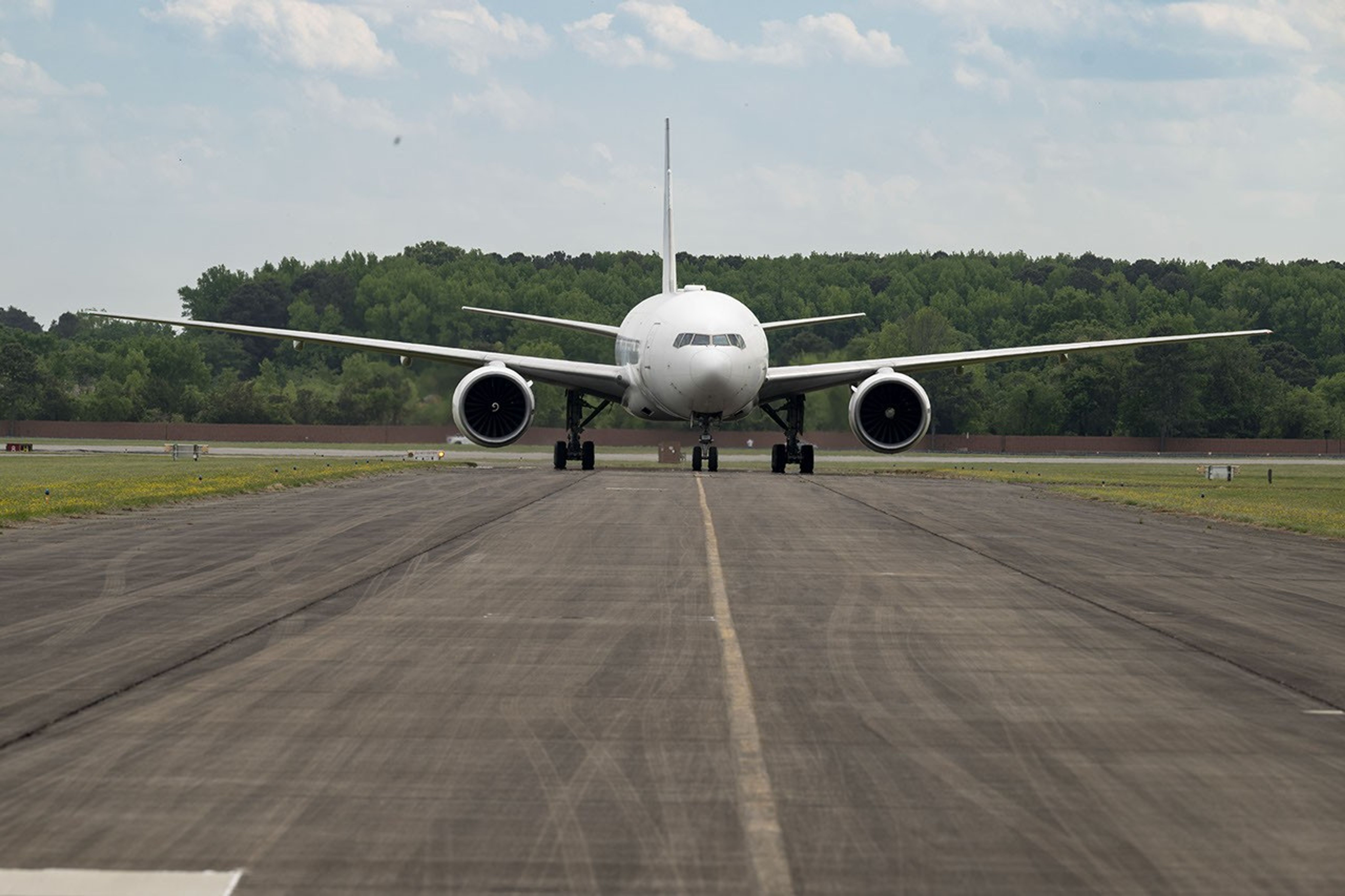
A Boeing 777 wide-body twin-engine aircraft looms on a taxiway, viewed directly from the front.
NASA’s 777 aircraft is gearing up to start science flights. Structural modifications – like enlarged cabin windows and instrument portals – have transformed the former passenger plane into a flying laboratory. It’s seen here at Langley Research Center in Hampton, Virginia, in April 2026.
NASA/Ryan Hill

Two North American cities with air quality concerns are Atlanta and Mexico City. But the causes differ, with weather and terrain playing a role. To explore these differences, the Hemispheric Airborne Measurements of Air Quality (HAMAQ) mission will investigate areas of poor air in the two capitals and test how satellite information can help forecasting and mitigation efforts. The team will deploy two aircraft at different altitudes: NASA’s P-3B will fly close to the surface, directly measuring fine particle and gaseous pollutants, while the recently acquired 777 science jet will soar high above, mapping pollution with remote sensors.  NASA’s Langley Research Center in Hampton, Virginia, is leading the mission. 

Fast-changing north 

As the Arctic warms at least twice as fast as the rest of Earth, data collected today can help guide communities on the front lines of change.  

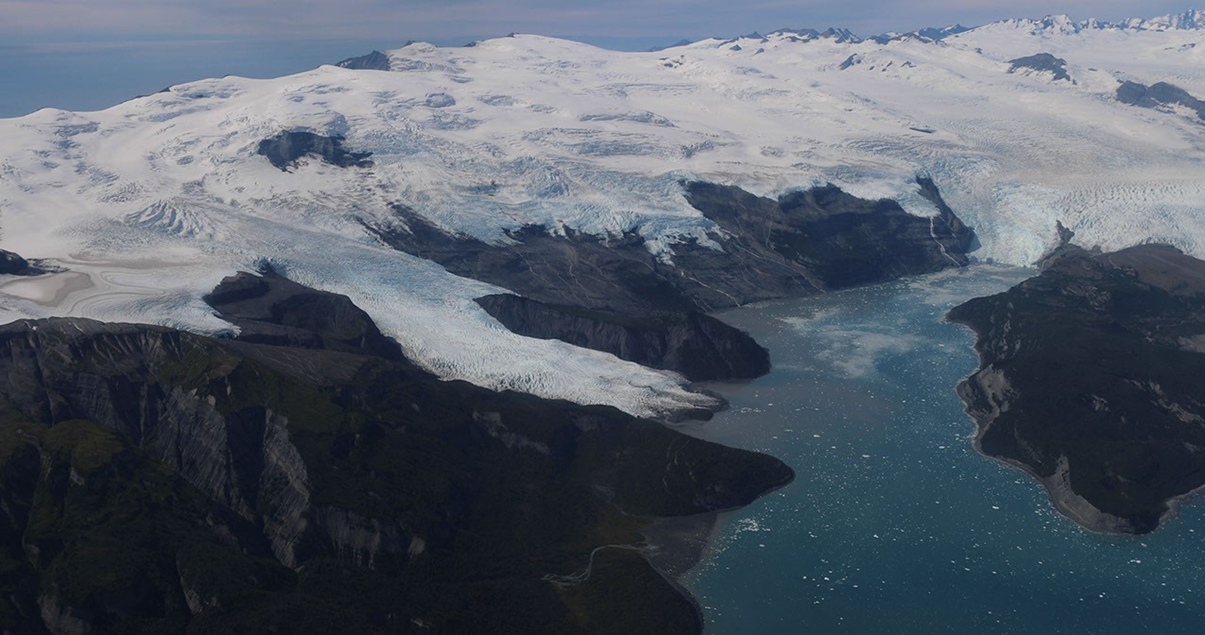
Amid a rugged landscape, a snow-white glacier spills into dark blue water.
Alaska’s glaciers are losing ice and contributing to sea level rise. NASA is tracking the changes from land, air, and space.
NASA

The Snow4Flow campaign, led by the University of Arizona, seeks to measure and model how far and fast glaciers are retreating in the far north. Traversing remote icescapes across Alaska, the Yukon, Arctic Canada, Greenland, and Svalbard, Norway, they’ll sound both the near-surface and frozen depths of hundreds of glaciers while flying over in a modernized WWII-era aircraft outfitted with a scanning laser altimeter and two custom radars. Their observations, combined with satellite data and advanced models of snowfall and glacier flow, will advance our understanding of how glaciers behave in different regions of the Arctic. The mission seeks to uncover not just what these glaciers look like beneath the surface today, but the processes that will drive changes in the future. 

As permafrost thaws, rivers on the doorstep of the Arctic become conveyor belts of carbon and sediment. NASA Goddard, and the City College of New York lead a multidisciplinary team studying how rivers, lagoons, and estuaries across Alaska’s North Slope interact with the Arctic Ocean. The project, called Frontlines of Rapidly Transforming Ecosystems (FORTE) will combine optical and radar measurements from satellites, planes, high-tech research vessels, drones, and underwater autonomous systems to track microscopic marine life, water flow, and chemistry. The team will collaborate with local and tribal communities to sustain observations over time and apply NASA assets to address emerging local needs and decision-making priorities.  

Landslide triggers 

When a slow-moving landslide in California suddenly collapsed and buried a section of coastal highway in 2017, scientists at NASA JPL wanted to know how precipitation swings played a role. JPL studies how water infiltrates and destabilizes hillslopes all over the world. The Landslide Change Characterization Experiment (LACCE) project will combine airborne synthetic aperture radar with land-based sensors to track how slopes in California are responding to a world of intensifying droughts and downpours. The project also takes aim at emerging landslide hazards in Alaska, where rapidly retreating glaciers are accelerating slope movements that have the potential to create mega-tsunamis.  

This series of images shows the collapse of the Mud Creek landslide in May 2017 along the Big Sur coast in Central California, and the subsequent repairs to Highway 1, which was damaged during the event.
Andy Ritchie/USGS Pacific Coastal and Marine Science Center

NASA’s Earth Venture Suborbital program, designed to be nimble and high impact, was established following a recommendation by the National Research Council in 2007. In the decades since, teams have studied phenomena, including blizzards, coral reefs, and ocean whirlpools.  

About the Author

Sally Younger

Share

Details

Last Updated
Jul 20, 2026

Burning Houses to Save Houses

We visited researchers seeking ways to make homes safer. They set a lot of fires.

© Will Crooks for The New York Times

A wildfire test at the Insurance Institute for Business & Home Safety lab in Richburg, S.C.

Google-backed satellites for wildfire detection launch as smoke chokes US, Canada

17 July 2026 at 20:50

As smoke from hundreds of burning wildfires spread across Canada and the United States, the first three operational satellites in the Google-backed FireSat program successfully launched into orbit. The satellites will begin providing wildfire detection capable of spotting even small fires in the United States, Australia, and Europe before the end of the year.

The launch of the microsatellites aboard a SpaceX Falcon 9 rocket from Vandenberg Space Force Base in California on July 7, 2026 marks a transition to “initial operational capability” for the FireSat constellation managed by the nonprofit Earth Fire Alliance. After a three-month testing period, the three satellites will begin actively providing data to fire agencies while covering every fire-prone region on Earth at least twice per day.

FireSat represents the first satellite constellation purpose-built for detecting wildfires, including spotting smaller fires that other satellites may miss. The satellites were designed by California-based satellite manufacturer Muon Space and have received over $15 million from Google to support initial deployment. Other notable financial supporters include the Bezos Earth Fund that committed $26 million.

Read full article

Comments

© Muon Space

Ontario Wildfire Smoke Moves East

16 July 2026 at 05:00
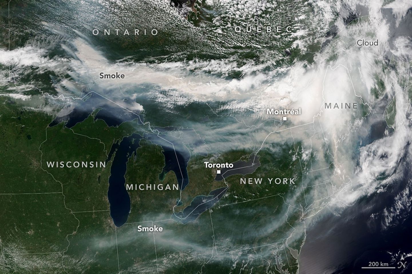
A satellite image shows brown smoke from wildfires in Ontario, Canada, streaming east across parts of Canada and the U.S. Areas of white clouds are mixed in with the smoke.
Smoke from wildland fires pours eastward over Canada and the U.S. in an image captured on the afternoon of July 14, 2026, by the VIIRS (Visible Infrared Imaging Radiometer Suite) on the NOAA-21 satellite.
NASA Earth Observatory/Lauren Dauphin

After a slow start to Canada’s 2026 fire season, activity picked up by the end of June amid dry, warm conditions and returned closer to the 25-year average. By mid-July, almost 850 fires were actively burning across the country, according to the Canadian Interagency Forest Fire Centre. More than 180 of those were burning in Ontario.

This NOAA-21 image, acquired on the afternoon of July 14, 2026, shows smoke billowing from the Ontario fires. Winds carried the smoke primarily southeast over much of the southern part of the province, as well as parts of Quebec and the U.S. Midwest and Northeast, tinting the sky shades of gray and yellow and the Sun orange in many areas.

The smoke’s impact on air quality varied, depending largely on altitude. In areas where smoke was high in the atmosphere, air quality impacts were negligible; where it drifted closer to the ground, conditions worsened. Air quality in Toronto, for instance, reached unhealthy levels, according to AirNow. People in the southern parts of the province were also grappling with a heat wave, compounding the health risks.

Much of the smoke came from fires in Northwestern Ontario, where eight blazes saw significant growth on July 13 and 14. The fires prompted officials to issue evacuation orders for several communities in this part of the province, according to news reports.

As of July 14, fires across Canada have burned 1.9 million hectares (4.7 million acres) since the start of the year—still well below the season totals from the extreme fire years of 2023 and 2025. How the rest of the season plays out remains to be seen. A seasonal fire outlook—compiled by wildland fire experts from the U.S., Canada, and Mexico—shows where fire conditions are more or less likely through July, August, and September.

NASA Earth Observatory image by Lauren Dauphin, using VIIRS data from NASA EOSDIS LANCE , GIBS/Worldview , and the Joint Polar Satellite System (JPSS). Story by Kathryn Hansen.

Downloads

A satellite image shows brown smoke from wildfires in Ontario, Canada, streaming east across parts of Canada and the U.S. Areas of white clouds are mixed in with the smoke.

July 14, 2026

JPEG (3.96 MB)

References & Resources

You may also be interested in:

Stay up-to-date with the latest content from NASA as we explore the universe and discover more about our home planet.

Fighting Fire With Fire
3 min read

In fire-prone ecosystems in Australia’s Northern Territory, prescribed burns are lit to minimize the severity of fires later in the…

Article
Fires Tear Through Nebraska Grasslands
3 min read

Dry, warm, and windy conditions across the U.S. Great Plains led to extreme fire activity in March 2026.

Article
Cottonwood Fire Chars Utah
5 min read

The blaze burned more than 150 square miles and swept through parts of a ski resort.

Article

The post Ontario Wildfire Smoke Moves East appeared first on NASA Science.

Ontario Wildfire Smoke Moves East

16 July 2026 at 05:00
A satellite image shows brown smoke from wildfires in Ontario, Canada, streaming east across parts of Canada and the U.S. Areas of white clouds are mixed in with the smoke.
Smoke from wildland fires pours eastward over Canada and the U.S. in an image captured on the afternoon of July 14, 2026, by the VIIRS (Visible Infrared Imaging Radiometer Suite) on the NOAA-21 satellite.
NASA Earth Observatory/Lauren Dauphin

After a slow start to Canada’s 2026 fire season, activity picked up by the end of June amid dry, warm conditions and returned closer to the 25-year average. By mid-July, almost 850 fires were actively burning across the country, according to the Canadian Interagency Forest Fire Centre. More than 180 of those were burning in Ontario.

This NOAA-21 image, acquired on the afternoon of July 14, 2026, shows smoke billowing from the Ontario fires. Winds carried the smoke primarily southeast over much of the southern part of the province, as well as parts of Quebec and the U.S. Midwest and Northeast, tinting the sky shades of gray and yellow and the Sun orange in many areas.

The smoke’s impact on air quality varied, depending largely on altitude. In areas where smoke was high in the atmosphere, air quality impacts were negligible; where it drifted closer to the ground, conditions worsened. Air quality in Toronto, for instance, reached unhealthy levels, according to AirNow. People in the southern parts of the province were also grappling with a heat wave, compounding the health risks.

Much of the smoke came from fires in Northwestern Ontario, where eight blazes saw significant growth on July 13 and 14. The fires prompted officials to issue evacuation orders for several communities in this part of the province, according to news reports.

As of July 14, fires across Canada have burned 1.9 million hectares (4.7 million acres) since the start of the year—still well below the season totals from the extreme fire years of 2023 and 2025. How the rest of the season plays out remains to be seen. A seasonal fire outlook—compiled by wildland fire experts from the U.S., Canada, and Mexico—shows where fire conditions are more or less likely through July, August, and September.

NASA Earth Observatory image by Lauren Dauphin, using VIIRS data from NASA EOSDIS LANCE , GIBS/Worldview , and the Joint Polar Satellite System (JPSS). Story by Kathryn Hansen.

Downloads

A satellite image shows brown smoke from wildfires in Ontario, Canada, streaming east across parts of Canada and the U.S. Areas of white clouds are mixed in with the smoke.

July 14, 2026

JPEG (3.96 MB)

References & Resources

You may also be interested in:

Stay up-to-date with the latest content from NASA as we explore the universe and discover more about our home planet.

Fighting Fire With Fire

3 min read

In fire-prone ecosystems in Australia’s Northern Territory, prescribed burns are lit to minimize the severity of fires later in the…

Article

Fires Tear Through Nebraska Grasslands

3 min read

Dry, warm, and windy conditions across the U.S. Great Plains led to extreme fire activity in March 2026.

Article

Cottonwood Fire Chars Utah

5 min read

The blaze burned more than 150 square miles and swept through parts of a ski resort.

Article
❌