❌

Normal view

New NASA Earth Missions Gear Up to Start Science Flights  

20 July 2026 at 19:25
6 Min Read

New NASA Earth Missions Gear Up to Start Science Flights  

Satellite imagery captured wildfires burning hot enough to generate pyrocumulonimbus clouds north of Lake Superior in July 2026. NASA aircraft will help scientists study the powerful storms as they develop.
Credits:
CSU/CIRA & NOAA

Landslides in Alaska. Air quality in Atlanta. Fire clouds out West. From the Arctic fringes to farm country, NASA’s newest class of suborbital Earth Venture missions is gearing up to deliver science that will benefit communities in the United States and beyond. 

The six projects will mobilize hundreds of scientists and pilots from NASA, the U.S. Navy, universities, and other institutions over the next several years. While the investigations range across topics, a defining feature of suborbital missions is the use of sensors mounted on aircraft. 

Airborne remote sensing serves as a bridge between ground-based instruments and satellites. Data collected via planes, helicopters, drones, and balloons can fill in gaps in computer models used by weather forecasters, city planners, and others.  

When wildfires create their own weather 

The first project to take wing this summer is Injected Smoke and PYRocumulonimbus Experiment (INSPYRE), led by the Naval Research Laboratory. From mission headquarters in Colorado, the team will chase one of the least understood forms of severe weather on Earth: towering “fire clouds” generated when extreme wildfires burn hot enough to brew their own thunderstorms.  

Pyrocumulonimbus clouds crackle with lighting in imagery captured over Utah and Colorado by the GOES-18 satellite in early July 2026.
CSU/CIRA & NOAA

Smoky and crackling with lightning, these unique storms can create blind spots for aviators above and spark new blazes below. Measuring and mapping the dangerous storms as they develop in real-time will help scientists forecast them in the future. Several aircraft, including NASA’s high-altitude ER-2, flying out of Montana, will carry a large suite of instruments over wildfire-generated storm systems. Among them will be two state-of-the-art infrared wildfire trackers, which were developed at NASA’s Jet Propulsion Laboratory (JPL) in Southern California and will be flying as part of the agency’s FireSense program.  

Testing the air over farmland, megacities 

Agricultural emissions represent an important and understudied part of Earth’s land and atmosphere systems. The FarmFlux mission, which kicks off this year, will deploy more than a dozen sensors to measure ozone, methane, ammonia, particulates, and other pollutants rising from agricultural lands and animal farms stretching from the Midwest to California’s Central Valley. These emissions affect human health, global climate, and stratospheric ozone. The mission is led by NASA’s Goddard Space Flight Center in Greenbelt, Maryland, along with Colorado State University, and Boston University. 

A Boeing 777 wide-body twin-engine aircraft looms on a taxiway, viewed directly from the front.
NASA’s 777 aircraft is gearing up to start science flights. Structural modifications – like enlarged cabin windows and instrument portals – have transformed the former passenger plane into a flying laboratory. It’s seen here at Langley Research Center in Hampton, Virginia, in April 2026.
NASA/Ryan Hill

Two North American cities with air quality concerns are Atlanta and Mexico City. But the causes differ, with weather and terrain playing a role. To explore these differences, the Hemispheric Airborne Measurements of Air Quality (HAMAQ) mission will investigate areas of poor air in the two capitals and test how satellite information can help forecasting and mitigation efforts. The team will deploy two aircraft at different altitudes: NASA’s P-3B will fly close to the surface, directly measuring fine particle and gaseous pollutants, while the recently acquired 777 science jet will soar high above, mapping pollution with remote sensors.  NASA’s Langley Research Center in Hampton, Virginia, is leading the mission. 

Fast-changing north 

As the Arctic warms at least twice as fast as the rest of Earth, data collected today can help guide communities on the front lines of change.  
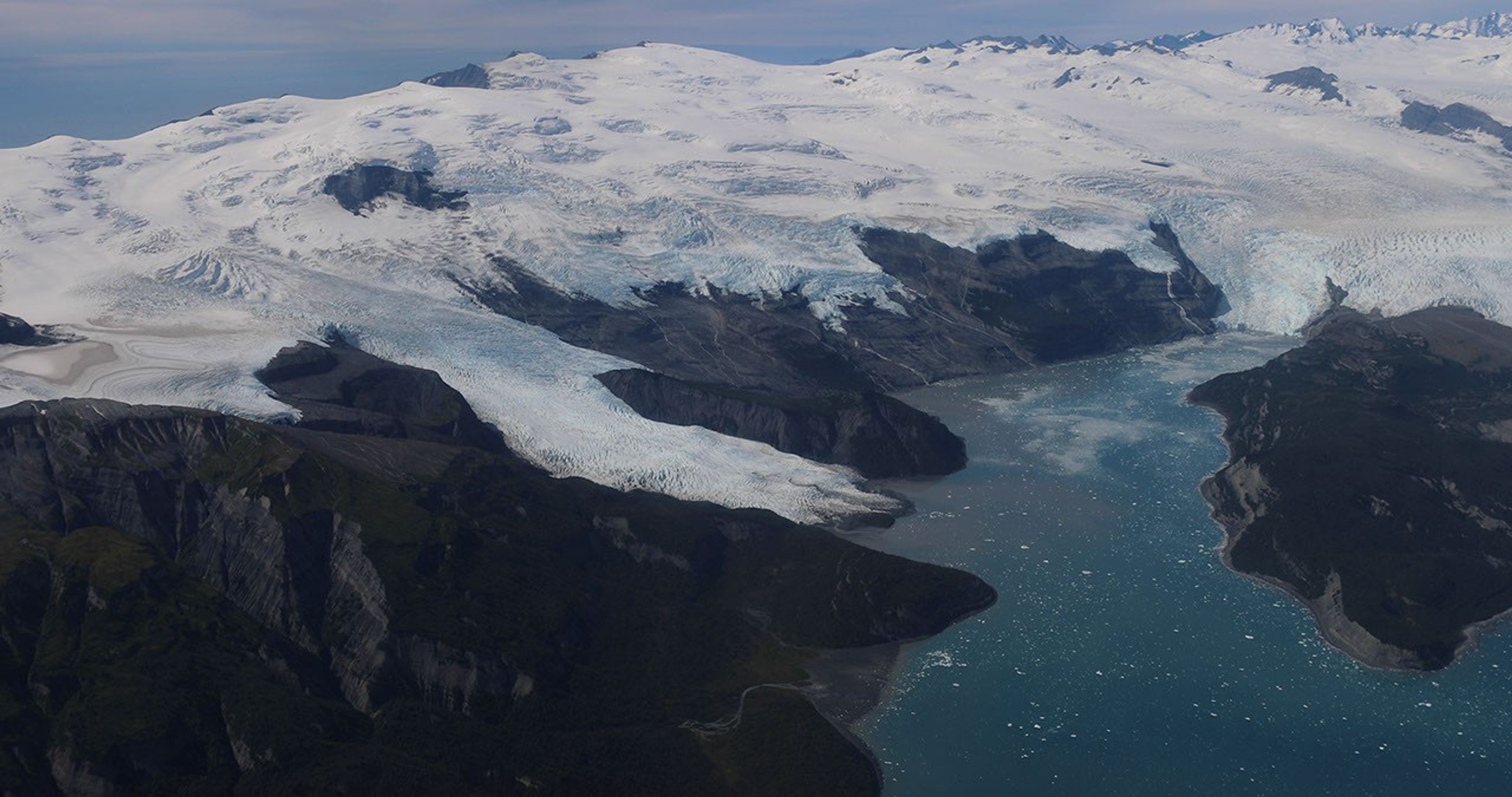
Amid a rugged landscape, a snow-white glacier spills into dark blue water.
Alaska’s glaciers are losing ice and contributing to sea level rise. NASA is tracking the changes from land, air, and space.
NASA

The Snow4Flow campaign, led by the University of Arizona, seeks to measure and model how far and fast glaciers are retreating in the far north. Traversing remote icescapes across Alaska, the Yukon, Arctic Canada, Greenland, and Svalbard, Norway, they’ll sound both the near-surface and frozen depths of hundreds of glaciers while flying over in a modernized WWII-era aircraft outfitted with a scanning laser altimeter and two custom radars. Their observations, combined with satellite data and advanced models of snowfall and glacier flow, will advance our understanding of how glaciers behave in different regions of the Arctic. The mission seeks to uncover not just what these glaciers look like beneath the surface today, but the processes that will drive changes in the future. 

As permafrost thaws, rivers on the doorstep of the Arctic become conveyor belts of carbon and sediment. NASA Goddard, and the City College of New York lead a multidisciplinary team studying how rivers, lagoons, and estuaries across Alaska’s North Slope interact with the Arctic Ocean. The project, called Frontlines of Rapidly Transforming Ecosystems (FORTE) will combine optical and radar measurements from satellites, planes, high-tech research vessels, drones, and underwater autonomous systems to track microscopic marine life, water flow, and chemistry. The team will collaborate with local and tribal communities to sustain observations over time and apply NASA assets to address emerging local needs and decision-making priorities.  

Landslide triggers 

When a slow-moving landslide in California suddenly collapsed and buried a section of coastal highway in 2017, scientists at NASA JPL wanted to know how precipitation swings played a role. JPL studies how water infiltrates and destabilizes hillslopes all over the world. The Landslide Change Characterization Experiment (LACCE) project will combine airborne synthetic aperture radar with land-based sensors to track how slopes in California are responding to a world of intensifying droughts and downpours. The project also takes aim at emerging landslide hazards in Alaska, where rapidly retreating glaciers are accelerating slope movements that have the potential to create mega-tsunamis.  

This series of images shows the collapse of the Mud Creek landslide in May 2017 along the Big Sur coast in Central California, and the subsequent repairs to Highway 1, which was damaged during the event.
Andy Ritchie/USGS Pacific Coastal and Marine Science Center

NASA’s Earth Venture Suborbital program, designed to be nimble and high impact, was established following a recommendation by the National Research Council in 2007. In the decades since, teams have studied phenomena, including blizzards, coral reefs, and ocean whirlpools.  

About the Author

Sally Younger

Share

Details

Last Updated
Jul 20, 2026

Ontario Wildfire Smoke Moves East

16 July 2026 at 05:00
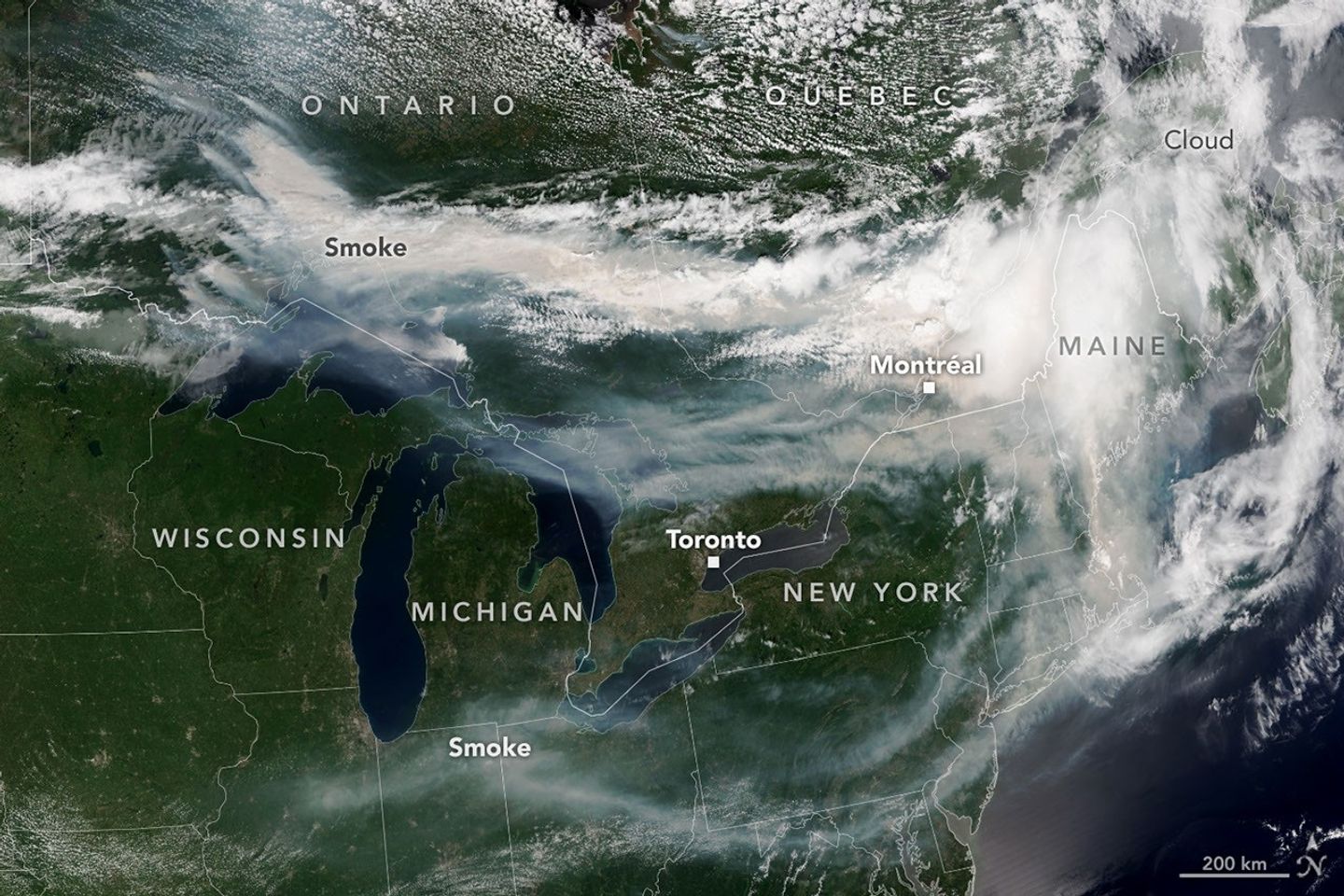
A satellite image shows brown smoke from wildfires in Ontario, Canada, streaming east across parts of Canada and the U.S. Areas of white clouds are mixed in with the smoke.
Smoke from wildland fires pours eastward over Canada and the U.S. in an image captured on the afternoon of July 14, 2026, by the VIIRS (Visible Infrared Imaging Radiometer Suite) on the NOAA-21 satellite.
NASA Earth Observatory/Lauren Dauphin

After a slow start to Canada’s 2026 fire season, activity picked up by the end of June amid dry, warm conditions and returned closer to the 25-year average. By mid-July, almost 850 fires were actively burning across the country, according to the Canadian Interagency Forest Fire Centre. More than 180 of those were burning in Ontario.

This NOAA-21 image, acquired on the afternoon of July 14, 2026, shows smoke billowing from the Ontario fires. Winds carried the smoke primarily southeast over much of the southern part of the province, as well as parts of Quebec and the U.S. Midwest and Northeast, tinting the sky shades of gray and yellow and the Sun orange in many areas.

The smoke’s impact on air quality varied, depending largely on altitude. In areas where smoke was high in the atmosphere, air quality impacts were negligible; where it drifted closer to the ground, conditions worsened. Air quality in Toronto, for instance, reached unhealthy levels, according to AirNow. People in the southern parts of the province were also grappling with a heat wave, compounding the health risks.

Much of the smoke came from fires in Northwestern Ontario, where eight blazes saw significant growth on July 13 and 14. The fires prompted officials to issue evacuation orders for several communities in this part of the province, according to news reports.

As of July 14, fires across Canada have burned 1.9 million hectares (4.7 million acres) since the start of the year—still well below the season totals from the extreme fire years of 2023 and 2025. How the rest of the season plays out remains to be seen. A seasonal fire outlook—compiled by wildland fire experts from the U.S., Canada, and Mexico—shows where fire conditions are more or less likely through July, August, and September.

NASA Earth Observatory image by Lauren Dauphin, using VIIRS data from NASA EOSDIS LANCE , GIBS/Worldview , and the Joint Polar Satellite System (JPSS). Story by Kathryn Hansen.

Downloads

A satellite image shows brown smoke from wildfires in Ontario, Canada, streaming east across parts of Canada and the U.S. Areas of white clouds are mixed in with the smoke.

July 14, 2026

JPEG (3.96 MB)

References & Resources

You may also be interested in:

Stay up-to-date with the latest content from NASA as we explore the universe and discover more about our home planet.

Fighting Fire With Fire
3 min read

In fire-prone ecosystems in Australia’s Northern Territory, prescribed burns are lit to minimize the severity of fires later in the…

Article
Fires Tear Through Nebraska Grasslands
3 min read

Dry, warm, and windy conditions across the U.S. Great Plains led to extreme fire activity in March 2026.

Article
Cottonwood Fire Chars Utah
5 min read

The blaze burned more than 150 square miles and swept through parts of a ski resort.

Article

The post Ontario Wildfire Smoke Moves East appeared first on NASA Science.

Ontario Wildfire Smoke Moves East

16 July 2026 at 05:00
A satellite image shows brown smoke from wildfires in Ontario, Canada, streaming east across parts of Canada and the U.S. Areas of white clouds are mixed in with the smoke.
Smoke from wildland fires pours eastward over Canada and the U.S. in an image captured on the afternoon of July 14, 2026, by the VIIRS (Visible Infrared Imaging Radiometer Suite) on the NOAA-21 satellite.
NASA Earth Observatory/Lauren Dauphin

After a slow start to Canada’s 2026 fire season, activity picked up by the end of June amid dry, warm conditions and returned closer to the 25-year average. By mid-July, almost 850 fires were actively burning across the country, according to the Canadian Interagency Forest Fire Centre. More than 180 of those were burning in Ontario.

This NOAA-21 image, acquired on the afternoon of July 14, 2026, shows smoke billowing from the Ontario fires. Winds carried the smoke primarily southeast over much of the southern part of the province, as well as parts of Quebec and the U.S. Midwest and Northeast, tinting the sky shades of gray and yellow and the Sun orange in many areas.

The smoke’s impact on air quality varied, depending largely on altitude. In areas where smoke was high in the atmosphere, air quality impacts were negligible; where it drifted closer to the ground, conditions worsened. Air quality in Toronto, for instance, reached unhealthy levels, according to AirNow. People in the southern parts of the province were also grappling with a heat wave, compounding the health risks.

Much of the smoke came from fires in Northwestern Ontario, where eight blazes saw significant growth on July 13 and 14. The fires prompted officials to issue evacuation orders for several communities in this part of the province, according to news reports.

As of July 14, fires across Canada have burned 1.9 million hectares (4.7 million acres) since the start of the year—still well below the season totals from the extreme fire years of 2023 and 2025. How the rest of the season plays out remains to be seen. A seasonal fire outlook—compiled by wildland fire experts from the U.S., Canada, and Mexico—shows where fire conditions are more or less likely through July, August, and September.

NASA Earth Observatory image by Lauren Dauphin, using VIIRS data from NASA EOSDIS LANCE , GIBS/Worldview , and the Joint Polar Satellite System (JPSS). Story by Kathryn Hansen.

Downloads

A satellite image shows brown smoke from wildfires in Ontario, Canada, streaming east across parts of Canada and the U.S. Areas of white clouds are mixed in with the smoke.

July 14, 2026

JPEG (3.96 MB)

References & Resources

You may also be interested in:

Stay up-to-date with the latest content from NASA as we explore the universe and discover more about our home planet.

Fighting Fire With Fire

3 min read

In fire-prone ecosystems in Australia’s Northern Territory, prescribed burns are lit to minimize the severity of fires later in the…

Article

Fires Tear Through Nebraska Grasslands

3 min read

Dry, warm, and windy conditions across the U.S. Great Plains led to extreme fire activity in March 2026.

Article

Cottonwood Fire Chars Utah

5 min read

The blaze burned more than 150 square miles and swept through parts of a ski resort.

Article

Aldi just announced a new range of cooling fans with prices starting at £6.99 — coming to the middle aisle very soon

  • Aldi has announced a new range of mini cooling fans
  • There's a tripod fan, a multi-directional globe fan, and an evaporative cooler
  • They'll be available in the middle aisle from July 2, starting at £6.99

Aldi, famed for its bargain home gadgets, has just announced a new set of budget-friendly cooling fans to help you stay cool without burning a hole in your wallet. The set of three fans will be available in the middle aisle of Aldi stores from July 2, so although they won't be able to stop you sweating during the current heatwave, you can make sure you're prepared the next time the temperature soars.

For me, the most interesting fan in the collection is the £6.99 Fan with Flexible Tripod. Not only is this the cheapest option, it's also the most flexible — literally. Its Joby GorillaPod-style legs bend and grip, so you can position it just right on your desk, wrap it around the handlebar of a pushchair, or attach it to a treadmill at the gym.

Three cooling fans on white background

(Image credit: Aldi)

Another intriguing option is the Portable Air Cooler with LED (£14.99), which lowers the temperature in your room using water and ice evaporative technology. Water absorbs quite a lot of heat when it evaporates, which has a significant cooling effect, which makes this kind of device (also charmingly known as a 'swamp cooler') an effective way to keep your cool without raising your electricity bill.

Finally, we have the Globe Fan with Multi Direction (£39.99), which looks more like a typical desk fan, but has an unusual "360-degree auto-rotating" head that pans all the way around your room. It comes with a remote control, and has three modes: Natural Wind, Drying (for laundry), and Sleep.

If you can't wait until next week and are willing to splash some more cash for quicker relief, we've rounding up all the best Amazon Prime Day deals on heatwave essentials including fans, portable air conditioners, and ice cream makers.

Ending Violence Against Women: Achievable Soon?

17 June 2026 at 12:41

In the pursuit of a society free from violence, the question of whether the elimination of violence against women is a realistic goal for the near future has become a pivotal topic within social science and policy circles. Research led by E. Gracia, recently published in Nature Communications, evaluates the multifaceted challenges and potential pathways for completely ridding societies of this pervasive issue. Despite historical setbacks and persistent prevalence, Gracia’s work proposes a cautiously optimistic framework to envision how strategic interventions, emerging technologies, and global cooperation might converge to bring about significant reductions, if not total eradication, of violence against women.

At the heart of Gracia’s analysis is a nuanced understanding that violence against women is deeply rooted in structural inequalities, cultural norms, and systemic power imbalances. These entrenched factors complicate attempts to eradicate such violence simply through legal reforms or isolated social programs. The research dissects the complexity behind the phenomenon, underlining the necessity for broad, cross-sectoral approaches that integrate education, legal systems, healthcare frameworks, economic empowerment, and cultural transformation on a global scale.

One of the critical barriers examined in the study is the persistent normalization and trivialization of violence against women in many societies. This normalization often manifests through social attitudes that minimize the severity of abuse or blame victims, thereby perpetuating cycles of silence and underreporting. Gracia’s research highlights how these deep-seated social perceptions form an invisible but potent barrier that law enforcement and public health strategies alone cannot dismantle without parallel efforts aimed at shifting collective consciousness.

The research further delves into the importance of multi-layered legal infrastructures that not only criminalize violence against women but also ensure accessibility, protection, and support for survivors. Gracia emphasizes that legislation must be matched with rigorous enforcement and judicial processes that uphold victims’ rights and foster trust in institutional mechanisms. Additionally, legal reforms should be adaptive to the evolving landscape of violence, including emerging forms such as digital abuse and cyber harassment, which have seen alarming rises in recent years.

Technology plays a dual role in the discussion. On one hand, it can be a vector for new forms of violence, as social media platforms and communication technologies sometimes facilitate harassment and abuse at scale. On the other hand, divergent technological advancements hold promise as tools for prevention, early intervention, and survivor support. Gracia’s research points to innovative uses of artificial intelligence and data analytics that could identify risk factors, predict potential violent episodes, and enable more targeted resource allocation in real time, potentially revolutionizing how societies manage and prevent violence against women.

Another dimension explored is the intersectionality of violence, acknowledging that women from marginalized communities, including racial minorities, immigrants, LGBTQ+ individuals, and those with disabilities, endure compounded vulnerabilities. The study rigorously argues that realistic eradication efforts must be inclusive, addressing the particular contexts and systemic discriminations these groups face, or risk perpetuating cycles of violence and exclusion.

Economic considerations also feature prominently in the study’s framework. Economic dependence is regularly cited as a critical factor that traps many women in abusive situations. Gracia suggests that sustainable economic empowerment, through access to education, fair employment, and social protection mechanisms, is indispensable to breaking these cycles. Such empowerment can provide survivors the independence necessary to leave abusive environments and face fewer barriers to full social participation.

Furthermore, the report evaluates the role of education as a foundational pillar in the fight against violence. Education campaigns targeting children, adolescents, and adults alike can reshape gender norms and teach consent, respect, and healthy relationship dynamics from an early age. According to Gracia, comprehensive and culturally sensitive educational programs could significantly alter long-term societal behaviors and attitudes, though their implementation requires political commitment and community engagement.

Global cooperation is presented as a sine qua non for meaningful progress. Violence against women is a universal issue transcending national boundaries, demanding coordinated international policies and shared best practices. Gracia’s study underlines that global frameworks and treaties must be strengthened and enforced, while simultaneously supporting local grassroots movements, which are often the most effective agents of change within their communities due to their cultural resonance and immediacy.

Despite these extensive strategic considerations, Gracia acknowledges the sobering reality that total elimination of violence against women is a colossal challenge laden with uncertainties. A realistic timeline must balance ambition with pragmatism, anticipating incremental progress rather than binary outcomes. The hope lies in convergence—multi-sectoral collaboration coupled with technological innovation and cultural shifts—creating an unstoppable momentum toward violence reduction.

In conclusion, the research presented by Gracia is both a call to action and a roadmap for the future. The elimination of violence against women may currently seem an almost utopian aspiration, yet it is rendered feasible through simultaneous advancements in law, technology, education, economic empowerment, and social mobilization. These domains, working in concert, have the potential to dismantle the foundations of gendered violence that are deeply embedded over centuries of systemic inequities.

This study encourages policymakers, practitioners, scholars, and society at large to rethink existing approaches and commit to sustained, evidence-based interventions. Achieving substantial progress requires embracing complexity and rejecting simplistic quick fixes, channeling resources into long-term transformative change rather than short-lived initiatives. The vision of a future where women can live free of violence is not merely an idealistic hope but an urgent imperative grounded in rigorous research and collective will.

As discussions around gender-based violence continue to unfold globally, Gracia’s work offers a crucial scientific framework that transcends rhetoric, providing actionable insights for moving the needle decisively. It inspires renewed optimism that with strategic alignment and innovation, violence against women can be substantially reduced, and eventually eliminated—a milestone that would signal a profound triumph for human rights and dignity worldwide.


Subject of Research: Violence against women and its potential elimination in the near future.

Article Title: Is the elimination of violence against women a realistic goal for the near future?

Article References:
Gracia, E. Is the elimination of violence against women a realistic goal for the near future?. Nat Commun 17, 5313 (2026). https://doi.org/10.1038/s41467-026-74656-y

Image Credits: AI Generated

DOI: https://doi.org/10.1038/s41467-026-74656-y

Inequality Amplifies Climate Disaster Risks Globally

17 June 2026 at 11:40

As the frequency and intensity of climate-related disasters escalate on a global scale, a groundbreaking study sheds new light on a critical and often overlooked dimension of risk: the profound impact of inequality in human development. In research published in Nature Communications, an international team of scientists led by Teber, K., Sippel, S., and Krause, M. reveals that disparities in human development significantly amplify the vulnerability of populations to climate-induced hazards, complicating disaster preparedness and response efforts worldwide.

While the physical manifestations of climate change—rising temperatures, extreme weather events, and sea-level rise—have been extensively documented, the interplay between socioeconomic factors and disaster risk has not been fully elucidated until now. This study meticulously integrates human development metrics with environmental exposure data to quantify how inequalities exacerbate the consequences of climate disasters. By doing so, it provides new insights into risk assessment models that have traditionally prioritized hazard exposure over social vulnerability.

Central to the researchers’ approach is the utilization of the Human Development Index (HDI), which incorporates income, education, and health dimensions, to evaluate disparities both within and across countries. The team employed advanced geospatial analyses to map the confluence of low human development and high climate hazard exposure, uncovering hotspots where disaster risk is magnified by social inequities. These findings underscore that vulnerability extends beyond mere exposure to danger, deeply rooted in systemic inequalities that limit adaptive capacities.

The study reveals a stark pattern: regions with lower human development indices experience disproportionately higher disaster impacts, even when faced with similar climatic hazards compared to more developed areas. This disparity is attributed to factors such as inadequate infrastructure, limited access to healthcare, poor education, and economic constraints that together impair communities’ ability to prepare for, respond to, and recover from disasters.

Technically, the authors introduced novel risk amplification indices that integrate HDI components with hazard intensity and frequency data. This composite metric quantifies how social factors amplify baseline risk, offering a more nuanced predictive framework that can inform targeted interventions. Their methodology leverages machine learning algorithms to analyze large-scale data sets, including remote sensing inputs, socioeconomic surveys, and historical disaster records.

Perhaps most strikingly, the analysis highlights that even incremental improvements in human development metrics can substantially mitigate disaster risks. For example, enhancements in education and healthcare access foster resilience by equipping individuals and communities with knowledge, resources, and capacities essential for effective disaster management. Conversely, deep inequalities create feedback loops that not only increase immediate disaster impacts but also prolong recovery processes, entrenching vulnerability across generations.

The implications of this research are far-reaching for policymakers, disaster risk managers, and international development agencies. It challenges the prevailing paradigm that treats climate risk primarily as a function of environmental exposure, advocating instead for integrated strategies that explicitly address human development inequalities. This approach aligns with the principles of sustainable development and climate justice, calling for equitable investments in social infrastructure alongside climate adaptation measures.

Moreover, the study engages with the broader discourse on resilience by illuminating how socio-economic determinants influence adaptive capacity. It resonates with existing frameworks such as the Sendai Framework for Disaster Risk Reduction, which emphasize reducing underlying risk drivers. By providing empirical evidence linking human development disparities directly to heightened disaster risk, it strengthens the case for multidimensional risk reduction policies.

The authors also caution against simplistic or reactive disaster management approaches that neglect the complex socio-economic landscape. Investments solely focused on physical infrastructure or early warning systems, while vital, are insufficient if communities remain socially and economically fragile. Instead, a holistic paradigm embracing human development as a core component of disaster risk reduction can lead to more sustainable and equitable outcomes.

From a technical perspective, the research outlines future avenues for refining integrated risk models by incorporating real-time socioeconomic data and enhancing the granularity of development indices. Such dynamism is crucial in capturing evolving vulnerabilities amid rapid urbanization, demographic shifts, and climate variability. This adaptability can improve predictive accuracy, helping anticipate disaster hotspots and allocate resources more efficiently.

The study’s findings also invite critical reflection on the intersections of climate change, inequality, and governance. They suggest that mitigating climate disaster risks requires not only technological innovations but also profound socio-political transformations that address systemic inequities. Strengthening governance frameworks that promote inclusive participation and equitable resource distribution is key to achieving the dual goals of human development and climate resilience.

Importantly, this research situates human development inequality not as a peripheral issue but as a central amplifier of disaster risk with cascading social, economic, and environmental consequences. By integrating interdisciplinary methods spanning environmental science, social research, and data analytics, it exemplifies the complexity of the climate risk challenge and the necessity of multifaceted solutions.

This study arrives at a crucial moment when global climate policies are increasingly recognizing the imperative to embed equity considerations within adaptation and mitigation frameworks. It provides robust data-driven evidence that such equity is not merely a moral imperative but a practical necessity for reducing disaster risk and safeguarding vulnerable populations worldwide.

In sum, the work by Teber and colleagues marks a pivotal advancement in climate risk science, offering a transformative lens through which to view the vulnerabilities that shape disaster outcomes. It redefines risk not as an isolated environmental phenomenon but as a socially embedded condition influenced profoundly by human development disparities. Emerging from this new understanding is a clarion call to reimagine disaster risk reduction through the prism of equity, justice, and sustainable development.

As climate change continues to intensify, the urgency of addressing human development inequalities in disaster risk assessment and management could determine the resilience of entire communities and nations. This integrative, data-informed framework has the potential to guide future policies aimed at building a safer, more equitable world capable of withstanding the increasing challenges posed by a changing climate.

Subject of Research:
Climate-related disaster risk amplification due to inequality in human development

Article Title:
Inequality in human development amplifies climate-related disaster risk

Article References:
Teber, K., Sippel, S., Krause, M. et al. Inequality in human development amplifies climate-related disaster risk. Nat Commun 17, 5067 (2026). https://doi.org/10.1038/s41467-026-73873-9

Image Credits:
AI Generated

DOI:
https://doi.org/10.1038/s41467-026-73873-9

Insulin-Like Growth Factor-1 Links to Older Adults’ Gait

17 June 2026 at 07:09

In a groundbreaking study set to reshape our understanding of aging, researchers have delved into the intricate relationship between insulin-like growth factor-1 (IGF-1) and various aspects of gait dynamics in older adults. This pioneering investigation leverages wearable sensor technology to decode how IGF-1 influences gait vigor, symmetry, and stability—parameters crucial to mobility and fall prevention in aging populations. As the global demographic shifts towards an older average age, insights like these are not only timely but carry profound implications for enhancing quality of life and reducing healthcare burdens associated with age-related mobility decline.

IGF-1, a hormone structurally similar to insulin, plays a pivotal role in growth and development, muscle function, and neuroprotection. Its significance extends beyond mere biochemical pathways; it acts as a linchpin connecting endocrine health to physical capability in later years. The scientific community has long speculated about the hormone’s potential role in preserving or enhancing motor functions, but empirical evidence directly relating IGF-1 levels with gait characteristics in older adults has remained scarce until now.

This study distinguishes itself through the innovative use of wearable sensor arrays, marking a shift from traditional laboratory-based gait analysis to more ecologically valid, real-world assessments. These sensors capture subtle variations in gait patterns, including vigor, which refers to the intensity and power behind each step; symmetry, the evenness of movement between left and right limbs; and stability, the ability to maintain balance and resist destabilizing forces. Such metrics provide a multidimensional view of an individual’s mobility profile, transcending simplistic measures like walking speed.

Collecting data from a robust cohort of older adults, the researchers meticulously correlated circulating levels of IGF-1 with recorded gait parameters. What emerged was a nuanced portrait revealing that higher IGF-1 concentrations were generally associated with greater gait vigor and improved symmetry, suggesting that this hormone might underpin both the muscular strength and neuromuscular coordination essential for efficient walking. Conversely, diminished IGF-1 corresponded with compromised gait performance, potentially flagging individuals at risk for mobility-related complications.

One of the most striking findings centers on gait stability, a critical factor in fall prevention among seniors. Falls constitute a leading cause of injury and mortality in the elderly population, often triggered by instability during locomotion. The study’s data indicated that participants with elevated IGF-1 exhibited enhanced stability metrics, inferring a protective role for this hormone in maintaining balance and preventing falls. This connection not only advances scientific understanding but also lays groundwork for targeted interventions.

The implications of the study extend into clinical practice, where wearable sensor technology could be harnessed alongside biomarker profiling to develop personalized mobility enhancement strategies. This dual approach holds promise for early detection of decline in motor function and proactive management through tailored exercise regimens or pharmacological modulation of IGF-1 pathways. Such innovations resonate strongly with the burgeoning field of precision medicine in geriatric care.

Moreover, the study casts fresh light on the complex interaction between endocrine health and musculoskeletal performance, hinting at underlying mechanisms that may involve IGF-1’s influence on muscle mass maintenance, neuroplasticity, and even cognitive function related to motor planning. This holistic perspective suggests that interventions aimed at modulating IGF-1 could yield multifaceted benefits, from physical mobility gains to mental well-being enhancements.

Future research inspired by these findings is poised to explore longitudinal impacts of IGF-1 modulation and its potential synergistic effects when combined with lifestyle modifications such as resistance training or nutritional optimization. The integration of wearable sensor data streams with longitudinal biochemical assays could unlock predictive models for decline and recovery patterns, setting a new standard in aging research methodologies.

Importantly, this study also exemplifies the transformative power of wearable technology in health sciences, shifting the paradigm towards continuous monitoring and real-time feedback. Such technologies empower individuals and clinicians alike with actionable insights, fostering a proactive approach to aging gracefully and independently.

In summary, this research elucidates a pivotal hormonal link influencing the subtle dynamics of gait, a vital indicator of overall health and autonomy in older adults. By marrying cutting-edge sensor technology with biochemical analytics, it opens avenues for innovative diagnostic and therapeutic tools that hold great promise for mitigating age-associated mobility challenges.

As the population ages globally, findings like these not only offer hope but also a scientific roadmap to extend the healthspan of older adults, promoting not just longer life but better quality of movement and function. This convergence of endocrinology, biomechanics, and wearable tech heralds an exciting era in gerontological research and care.

The study’s authors advocate for a multidisciplinary approach, integrating endocrinologists, biomechanists, geriatricians, and data scientists to fully harness the potential of these insights. The convergence of expertise is paramount to translating molecular findings into tangible health outcomes for the elderly demographics worldwide.

In closing, the exploration of insulin-like growth factor-1 as a biomarker intimately linked with gait parameters embodies a critical frontier in aging research. With wearable sensors providing real-world data granularity, the path is paved to innovate not only diagnostics but comprehensive management strategies to preserve mobility and independence, core facets of human dignity and quality of life.


Subject of Research: Associations of insulin-like growth factor-1 (IGF-1) with gait vigor, symmetry, and stability metrics in older adults using wearable sensor technology

Article Title: Associations of insulin-like growth factor-1 with gait vigor, symmetry, and stability metrics measured by wearable sensors in older adults

Article References: Zhang, C., Liu, Y., Zhang, Y. et al. Associations of insulin-like growth factor-1 with gait vigor, symmetry, and stability metrics measured by wearable sensors in older adults. BMC Geriatr (2026). https://doi.org/10.1186/s12877-026-07822-y

Image Credits: AI Generated

Rising Aircraft Emissions Threaten Air Quality, Health

16 June 2026 at 16:35

As the world continues to witness unprecedented growth in air travel, a groundbreaking study published in Communications Earth & Environment reveals alarming insights into the global repercussions of accelerating aircraft emissions on air quality and human health. This landmark research meticulously quantifies how expanding aviation activities contribute to deteriorating atmospheric conditions and exacerbate public health crises worldwide, underscoring an urgent need for global policy interventions and technological innovation.

The aviation sector, responsible for a substantial portion of anthropogenic greenhouse gas and pollutant outputs, has long been scrutinized for its environmental footprint. Yet, the intricate dynamics linking aircraft emissions to widespread air quality degradation and subsequent health implications have remained largely underexplored until now. Quadros, Nelen, Snellen, and colleagues harnessed sophisticated atmospheric modeling techniques combined with epidemiological data to elucidate these complex pathways with unprecedented precision.

Aircraft engines emit a cocktail of pollutants, including nitrogen oxides (NOx), particulate matter (PM), volatile organic compounds (VOCs), and carbon dioxide (CO2). These emissions initiate a cascade of atmospheric chemical reactions, creating secondary pollutants such as ozone and fine particulate matter, which profoundly impair air quality. The study’s simulation results reveal that aircraft emissions alone contribute significantly to elevated ground-level ozone concentrations, particularly in densely populated and heavily trafficked air corridors.

One of the study’s pivotal findings focuses on the spatial distribution of pollution burdens. Regions adjacent to major airports and common flight routes exhibit air quality dips notably beyond local vehicular and industrial contributions. The researchers found that the transboundary nature of aircraft emissions facilitates the transport of chemically reactive species across continents, linking aviation activities not only to local but also to regional and global air pollution episodes.

In terms of human health, the implications are disturbing. The researchers applied integrated exposure-response functions to estimate the morbidity and mortality attributable to aviation-induced pollution. Their assessments suggest a substantial increase in respiratory ailments, cardiovascular diseases, and premature deaths attributable to aircraft emissions. Particularly vulnerable populations, such as urban dwellers, children, elderly individuals, and those with preexisting conditions, face disproportionate risks.

Moreover, the study highlights the synergistic effects of aircraft emissions with other urban pollutants, exacerbating harmful synergistic interactions that amplify health risks. For instance, the NOx and VOCs emitted interact under sunlight to generate ozone, a potent respiratory irritant, and exacerbate asthma symptoms. The authors stress the importance of recognizing these nonlinear effects for robust public health policy formulation.

Climate feedback mechanisms linked to aviation emissions emerge as a critical concern in the report. The authors delineate how nitrogen oxides released at high altitudes not only affect surface-level ozone but also perturb the radiative balance of the atmosphere. This creates complex feedback loops that potentially accelerate climate warming, indicating that the environmental cost of aviation extends beyond conventional pollutants to include broader climatic impacts.

Technology advances and mitigation strategies receive thorough evaluation in the study. The authors discuss current emission reduction technologies such as lean-burn engines, sustainable aviation fuels (SAFs), and operational measures like optimized flight paths and altitude adjustments. Despite their promise, the research cautions that without comprehensive adoption and scaling, these technologies alone may fall short of offsetting the forecasted growth in emissions.

The aviation sector is projected to expand considerably over the coming decades, driven by economic growth and increasing globalization. The study’s projections indicate that without stringent regulatory frameworks and aggressive emission reduction commitments, the global burden of aviation-induced air pollution and related health impacts will escalate dramatically, particularly in emerging economies with rapidly growing air traffic.

Policy recommendations form a cornerstone of the researchers’ conclusions. They advocate for coordinated international efforts to tighten emission standards, mandate SAF usage, and invest in next-generation propulsion technologies such as electric and hydrogen-powered aircraft. Furthermore, integrating aviation sector goals into broader air quality management and climate policies is deemed essential to maximize health and environmental benefits.

In addition to technological and regulatory measures, the report emphasizes the role of real-time monitoring networks and data-sharing frameworks. Enhanced surveillance of aircraft emissions and their atmospheric transformations can enable dynamic policy responses, better inform public health advisories, and foster transparency and accountability among stakeholders ranging from airlines to regulators.

The health economics dimension discussed in the study reveals enormous societal costs tied to aviation-related air pollution. Hospitalizations, lost productivity, and long-term healthcare expenditures attributed to pollution-induced diseases impose substantial financial burdens on governments and communities alike, reinforcing the public health imperative for aggressive mitigation.

Further research priorities identified in the report call for improved characterization of ultrafine particles emitted by aircraft engines, nuanced understanding of population exposure patterns near airports, and exploration of co-benefits arising from simultaneous air quality and climate interventions. Interdisciplinary collaboration combining atmospheric science, epidemiology, engineering, and policy studies is championed as the pathway to innovative solutions.

In light of this new research, the aviation industry stands at a crossroads. Balancing the undeniable economic and social advantages of air travel with its adverse environmental and health externalities necessitates transformative thinking and collaborative global action. The study’s revelations provide an indispensable scientific foundation for stakeholders to forge a sustainable aviation future.

This comprehensive investigation serves as a clarion call for urgent recognition of the aviation sector’s hidden consequences, urging policymakers, industry players, and the public to engage in proactive, science-informed strategies that safeguard air quality and human health on a planetary scale.

Subject of Research:
The study focuses on evaluating the global impact of increasing aircraft emissions on air quality and related human health outcomes, analyzing both direct and indirect effects through sophisticated atmospheric and epidemiological modeling.

Article Title:
Global air quality and human health impacts of growing aircraft emissions

Article References:
Quadros, F.D.A., Nelen, R., Snellen, M. et al. Global air quality and human health impacts of growing aircraft emissions. Commun Earth Environ (2026). https://doi.org/10.1038/s43247-026-03732-4

Image Credits: AI Generated

DOI: 10.1038/s43247-026-03732-4

Keywords:
Aircraft emissions, air quality, human health, nitrogen oxides, particulate matter, ozone formation, aviation pollution, atmospheric modeling, public health impact, sustainable aviation fuels

City Racial Segregation Stats Resist Aggregation Bias

16 June 2026 at 14:56

Residential segregation remains one of the most pressing and persistent challenges facing American cities today. It fractures economic opportunity, stifles social cohesion, and underpins many of the inequities visible across urban landscapes. Despite decades of research into the patterns and consequences of segregation, the measurement of these patterns has long grappled with a thorny methodological problem: how the artificial boundaries used to aggregate population data influence estimates of segregation. This problem, often called the modifiable areal unit problem (MAUP), arises because segregation indices depend critically on how spatial units—like Census tracts—are defined and aggregated. Until now, a comprehensive assessment of this source of variability has remained out of reach.

In a groundbreaking study published in Nature Cities, researchers have employed an innovative approach that leverages redistricting algorithms to simulate millions of alternative spatial boundary configurations. These alternative maps adhere to official Census criteria but shuffle tract boundaries within those parameters, creating an unprecedented way to probe how sensitive traditional segregation indices are to the arbitrary boundaries that political and statistical geographies impose. The results challenge established assumptions and ultimately affirm the practicality—and peculiar robustness—of Census tracts as tools for racial segregation measurement across U.S. cities.

Traditionally, segregation research relies on fixed geographic units, most commonly Census tracts, to evaluate how populations of different racial and ethnic groups are distributed across cities. But these tracts, while designed to be relatively homogeneous and stable, are shaped by administrative decisions that do not directly correspond to natural or social boundaries. Since the exact delineation of these tracts can stray substantially, estimates of segregation derived from them have always carried a hidden risk of aggregation bias. Sensitivity analyses that explore alternate aggregations have been limited in scope, relying on hypothetical adjustments or crude spatial aggregations, rather than systematically exploring the vast universe of plausible boundary alternatives.

The new study breaks this impasse by borrowing tools from political redistricting theory—where map-drawing is a highly contested and technically advanced field. The researchers developed a computational framework using redistricting software capable of generating millions of alternate Census tract configurations within each city. These alternative configurations satisfy Census Bureau guidelines on population equality and contiguity, approximating what feasible boundary revisions might realistically look like. By calculating segregation indices for each configuration, the team was able to characterize the full probabilistic distribution of segregation estimates that arise purely from boundary variability.

Their analysis covered a wide range of U.S. cities, from smaller metropolitan areas with relatively few tracts to sprawling urban agglomerations comprising thousands of tracts. The findings reveal a striking pattern: in smaller cities, the estimated levels of racial segregation can fluctuate substantially when alternative boundary maps are considered. This variability highlights the dangers of over-reliance on fixed census geographies in contexts where granularity is limited and aggregation artifacts become significant. In contrast, as city size grows and spatial units multiply, the observed segregation estimates converge; the impact of redrawing boundaries diminishes, and estimates become more stable and trustworthy.

Perhaps more surprisingly, the study found no evidence that existing Census tract-based estimates are systematically biased in either direction. The official tract boundary estimates tended to fall near the mean of the simulated distribution of alternative boundaries. This outcome challenges the often-expressed concern that Census tracts might drastically overstate or understate segregation. Instead, while individual estimates do carry inherent spatial aggregation uncertainty, the conventional measures are, on average, representative. This nuance adds an important layer of confidence to decades of segregation research relying on these geographic units.

Technically, the probabilistic distributions generated by the redistricting simulations provide a novel way to frame segregation statistics in an uncertainty framework. Instead of presenting segregation as a point estimate, urban researchers and policymakers can now appreciate a spectrum of plausible segregation values conditioned on boundary choices. This opens avenues for more transparent reporting that reflects the inherent spatial ambiguity in aggregate data analysis, empowering better-informed decisions on interventions aimed at mitigating segregation and its effects.

The methodology itself is noteworthy for blending urban demographics with advanced computational geography. By applying constraints like population equivalence and spatial contiguity, the simulations closely mimic the federal redistricting process and ensure that the alternative boundaries are grounded in realistic criteria rather than purely theoretical constructs. This rigor elevates the findings beyond mere sensitivity checks, framing boundary uncertainty as a quantifiable dimension of segregation research rather than a theoretical limitation.

These insights carry significant implications not only for researchers but also for policymakers and activists engaged in urban planning, housing, and civil rights advocacy. Recognizing that reported segregation metrics come with an intrinsic range of variance caused by how boundaries are drawn can lead to greater caution in interpreting city rankings or trends over time. More fundamentally, it signals the need for complementary approaches that integrate non-aggregate data sources or spatially continuous methods to further refine segregation measurement.

The study also presents a generalizable framework adaptable to other domains where spatial aggregation introduces bias and uncertainty. Fields such as public health, environmental justice, and economic geography often rely on aggregated spatial data vulnerable to the MAUP. The redistricting simulation approach offers a powerful template for diagnosing and statistically correcting aggregation error in these varied contexts, paving the way for more robust spatial analyses across disciplines.

One of the most profound contributions of this research is its nuanced vindication of the Census tract as a unit of analysis. While researchers have long critiqued the arbitrariness inherent in fixed administrative boundaries, the study’s results demonstrate that in many urban contexts at scale, these units provide a sufficiently stable foundation for measuring segregation. This balancing of skepticism with empirical validation is rare in social science and signals a promising path toward methodological refinement rather than wholesale rejection of conventional metrics.

The findings also underscore the importance of city size and spatial scale in segregation measurement. Smaller cities, where the number of spatial units is limited, experience much greater volatility in segregation estimates. This volatility arises because each tract, or aggregation unit, represents a larger proportional share of the city’s population, amplifying boundary effects. Larger cities benefit from statistical smoothing through numerous smaller units, increasing estimate robustness. This insight could deeply inform urban comparative studies and the design of equitable zoning or integration policies tailored to city scale.

Going forward, the authors advocate for broad adoption and further development of their redistricting simulation platform. Enhancing the tool’s accessibility and integrating it with standard segregation calculations could democratize this approach, allowing urban researchers everywhere to rigorously address aggregation bias. Moreover, expanding simulations to explore additional boundary constraints or to incorporate social network data could refine understanding of how human geography and administrative geography intersect to shape segregation patterns.

The study arrives at a critical moment, as U.S. cities grapple with evolving demographic realities amid ongoing debates over race, equality, and urban policy. Precise and reliable measurement tools are foundational to both academic inquiry and effective governance. By making segregation measurement more transparent and statistically nuanced, this research provides a critical step towards evidence-based urban reform that acknowledges complexity without being paralyzed by it.

In conclusion, this pioneering study reframes the measurement of racial segregation by exposing the variability introduced through spatial aggregation while reassuring researchers and policymakers of the general reliability of established Census tract definitions. By harnessing computational redistricting techniques, it both deepens and democratizes understanding of urban racial geography, offering a blueprint for more rigorous and nuanced measurement in this socially consequential domain. The framework not only enriches segregation studies but sets a new standard for spatial data analysis in the social sciences, inviting an era where measurement uncertainty is openly acknowledged and expertly managed.

Subject of Research:
City-scale racial segregation measurement and spatial aggregation bias in U.S. metropolitan areas.

Article Title:
City racial segregation statistics are robust to aggregation bias.

Article References:
Brown, J.R., Kenny, C.T. & Simko, T. City racial segregation statistics are robust to aggregation bias. Nat Cities (2026). https://doi.org/10.1038/s44284-026-00459-3

Image Credits:
AI Generated

DOI:
https://doi.org/10.1038/s44284-026-00459-3

Air Pollution’s Daily Pulse Over the Northeast

11 June 2026 at 05:01
7:05 am
3:05 pm
A map of morning nitrogen dioxide shows elevated concentrations of the gas over a region stretching from New York City to Washington, D.C., at 7:05 a.m. on May 18, 2026. A second map of the same area shows much lower concentrations that afternoon.
TEMPO detected high concentrations of nitrogen dioxide during the morning commute at 7:05 a.m. local time on May 18, 2026 (left), along the New York-Washington corridor. The instrument detected lower levels of the gas at 3:05 p.m. (right), after chemical reactions involving nitrogen dioxide had contributed to elevated ozone concentrations in the afternoon.
NASA Earth Observatory/Michala Garrison
7:05 am
3:05 pm
TEMPO detected high concentrations of nitrogen dioxide during the morning commute at 7:05 a.m. local time on May 18, 2026 (left), along the New York-Washington corridor.The instrument detected lower levels of the gas at 3:05 p.m. EDT (right), after chemical reactions involving nitrogen dioxide had contributed to elevated ozone concentrations in the afternoon. NASA Earth Observatory images by Michala Garrison.

More than 35 million people live along the New York–Washington corridor and breathe the region’s air. While air quality has improved significantly in recent decades, outbreaks of ground-level ozone remain common, particularly in the warm summer months, when the chemical reactions that produce the pollutant accelerate and stagnant air allows ozone to accumulate.

A reminder of this seasonal phenomenon came earlier than usual in 2026, when a mid-May heat wave prompted the New York State Department of Health and the New York Department of Environmental Conservation to issue a health advisory on May 17 over concerns about ozone. The code orange advisory warned young people, older adults, and those working or exercising outdoors to limit activity due to ozone’s respiratory and cardiovascular health impacts.

As expected, ground-based air-quality sensors operated by state and federal agencies showed ozone reaching unhealthy levels for sensitive groups on May 18, something that typically happens several times per year. Meanwhile, NASA’s TEMPO (Tropospheric Emissions: Monitoring of Pollution) instrument observed the event from geostationary orbit 22,000 miles (35,000 kilometers) above the equator, a unique vantage point that allows the sensor to collect frequent observations of air pollution.

TEMPO detects nitrogen dioxide (NO2), a gas emitted by burning fuels, particularly by motor vehicles, that contributes to ozone formation. “There’s often a clear and interesting pattern in TEMPO’s nitrogen dioxide data during ozone alert days,” said Hazem Mahmoud, an atmospheric scientist at NASA’s Atmospheric Science Data Center at Langley Research Center. “We see high concentrations of nitrogen dioxide during the early morning commute that drop off sharply in the late afternoon as ozone increases.”

The decline occurs as sunlight fuels photochemical reactions involving nitrogen dioxide, volatile organic compounds, and oxygen that lead to ozone formation. By late afternoon, these reactions deplete much of the available nitrogen dioxide, slowing ozone production until the cycle begins again the next day.

The pair of images above underscores the pattern. The image on the left was acquired at 7:05 a.m. local time when nitrogen dioxide concentrations were high during the morning commute. By 3:05 p.m. (right), most of the nitrogen dioxide had declined substantially, and surface ozone levels were elevated (below). Meanwhile, afternoon sea breezes appear to have transported the remaining nitrogen dioxide slightly to the west. Note that the data shown is provisional, and processing methods are still being refined.

Sensors on earlier polar-orbiting satellites, such as OMI (Ozone Monitoring Instrument) and TROPOMI (Tropospheric Monitoring Instrument), sampled nitrogen dioxide over New York once per day. After its launch in 2023, TEMPO began providing data every hour, allowing researchers to track the evolution and dispersion of air pollution at much finer time scales. 

“TEMPO is helping fill data gaps between ground stations and allowing us to ask new questions,” Mahmoud said. The mission provides data that can improve not only air quality forecasts during crisis situations, such as wildfires, but also the atmospheric models used to forecast the daily rhythms of urban pollution. Such models help researchers understand how natural factors such as winds, humidity levels, and air temperatures influence pollution plumes over the course of a day.

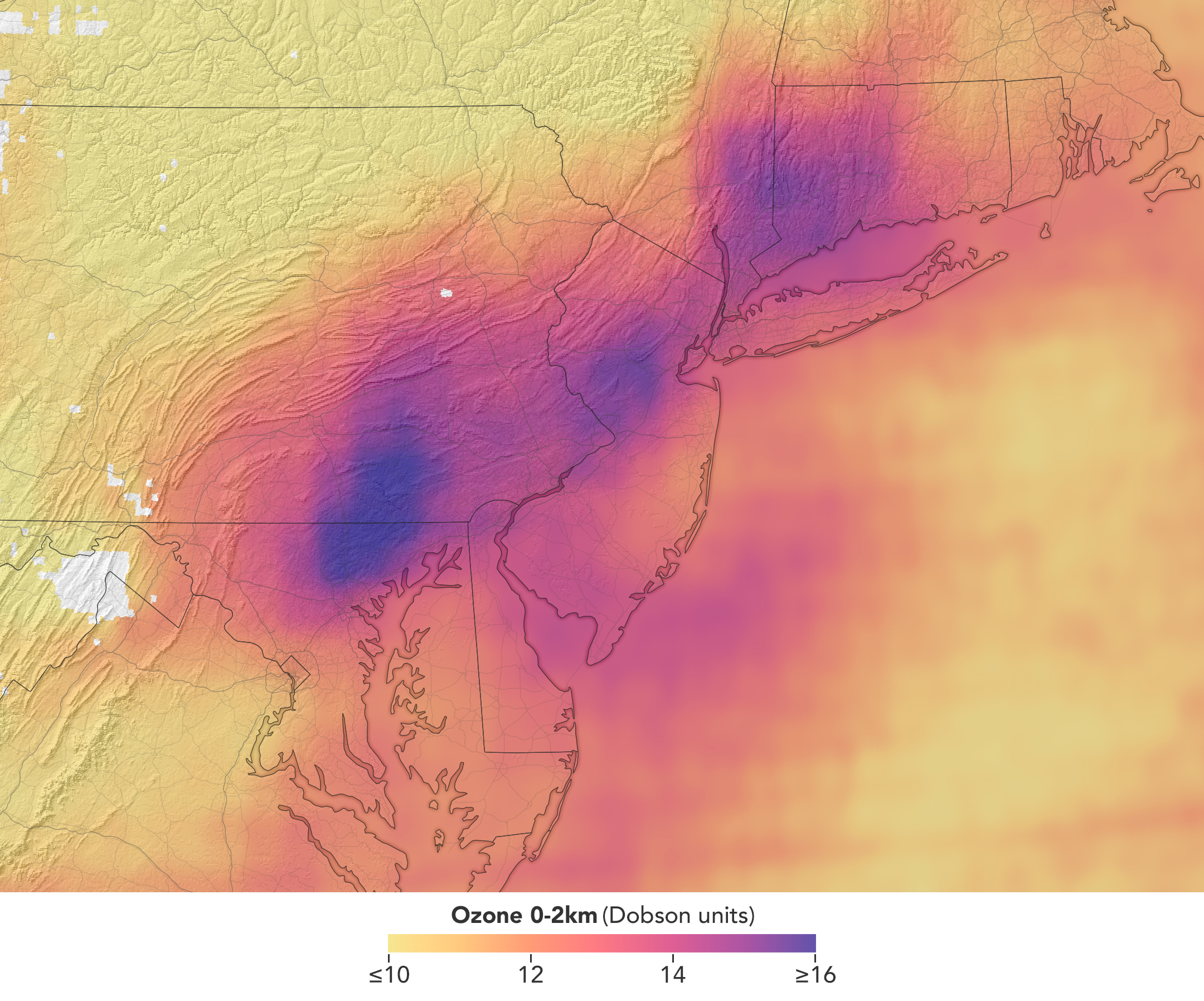
In a map of the eastern U.S., elevated ozone concentrations appear as a purple patch in an area extending from New York City to Washington, D.C.
TEMPO detected elevated ozone concentrations in an area extending from New York City to Washington, D.C., at 5:05 p.m. on May 18, 2026.
NASA Earth Observatory/Michala Garrison

TEMPO also detects ozone directly, but determining how much of that ozone is near the surface versus higher in the atmosphere can be challenging. Most of Earth’s ozone resides in the stratosphere, well above the troposphere, where people live and breathe. At times, however, stratospheric ozone can be transported downward into the troposphere. During events known as stratospheric intrusions, it can even descend far enough to affect air quality at the surface and add to the ozone produced at ground level.

By combining TEMPO observations with other sources of information, researchers are studying the processes that influence the distribution of ozone vertically in the atmosphere. On May 18, NASA’s ground-based tropospheric lidar network (TOLNet) in New York City recorded high concentrations of ozone near the surface, indicating that TEMPO was detecting mostly surface-level ozone associated with urban emissions and not ozone aloft, said Mahmoud.

However, on May 19, the same sensor observed a layer of ozone descending from above 5 kilometers (3 miles), he added, a clue that some of the ozone TEMPO detected that day may have originated in the stratosphere. “This is the type of information that leads to better air quality forecast models and more accurate alerts,” Mahmoud said. “Alerts can affect tens of millions of people and lead to disruptions in school, sports, and other activities, so it’s essential that they be as accurate as possible.”

On June 6, New York authorities issued another health advisory for ozone. People interested in following the event can access daily near-real-time TEMPO observations of ozone, nitrogen dioxide, and other gases on NASA’s Worldview browser, on an interactive Harvard & Smithsonian Center for Astrophysics browsing tool, and on NASA’s Earthdata portal.   

NASA Earth Observatory images by Michala Garrison, using TEMPO data from NASA Earthdata. Story by Adam Voiland.

Downloads

A map of morning nitrogen dioxide shows elevated concentrations of the gas over a region stretching from New York City to Washington, D.C., at 7:05 a.m. on May 18, 2026. A second map of the same area shows much lower concentrations that afternoon.

Nitrogen Dioxide – May 18, 2026 7:05 AM EDT

JPEG (2.52 MB)

A map of morning nitrogen dioxide shows elevated concentrations of the gas over a region stretching from New York City to Washington, D.C., at 7:05 a.m. on May 18, 2026. A second map of the same area shows much lower concentrations that afternoon.

Nitrogen Dioxide – May 18, 2026 3:05 PM EDT

JPEG (2.25 MB)

In a map of the eastern U.S., elevated ozone concentrations appear as a purple patch in an area extending from New York City to Washington, D.C.

Ozone – May 18, 2026 5:05 PM EDT

JPEG (2.10 MB)

References & Resources

You may also be interested in:

Stay up-to-date with the latest content from NASA as we explore the universe and discover more about our home planet.

Smoke Shrouds Northern Thailand
3 min read

Seasonal fires have darkened skies over Southeast Asia.

Article
Winter’s End Is Written in the Clouds
3 min read

As winter turned to spring, the skies over the Gulf of Alaska displayed textbook examples of numerous cloud formations.

Article
Extreme January Cold
3 min read

Following a significant winter storm, frigid temperatures lingered in late January 2026 across a vast swath of the U.S.

Article

The post Air Pollution’s Daily Pulse Over the Northeast appeared first on NASA Science.

Air Pollution’s Daily Pulse Over the Northeast

11 June 2026 at 05:01


7:05 am
3:05 pm

A map of morning nitrogen dioxide shows elevated concentrations of the gas over a region stretching from New York City to Washington, D.C., at 7:05 a.m. on May 18, 2026. A second map of the same area shows much lower concentrations that afternoon.
TEMPO detected high concentrations of nitrogen dioxide during the morning commute at 7:05 a.m. local time on May 18, 2026 (left), along the New York-Washington corridor. The instrument detected lower levels of the gas at 3:05 p.m. (right), after chemical reactions involving nitrogen dioxide had contributed to elevated ozone concentrations in the afternoon.
NASA Earth Observatory/Michala Garrison

7:05 am

3:05 pm


TEMPO detected high concentrations of nitrogen dioxide during the morning commute at 7:05 a.m. local time on May 18, 2026 (left), along the New York-Washington corridor.The instrument detected lower levels of the gas at 3:05 p.m. EDT (right), after chemical reactions involving nitrogen dioxide had contributed to elevated ozone concentrations in the afternoon. NASA Earth Observatory images by Michala Garrison.

More than 35 million people live along the New York–Washington corridor and breathe the region’s air. While air quality has improved significantly in recent decades, outbreaks of ground-level ozone remain common, particularly in the warm summer months, when the chemical reactions that produce the pollutant accelerate and stagnant air allows ozone to accumulate.

A reminder of this seasonal phenomenon came earlier than usual in 2026, when a mid-May heat wave prompted the New York State Department of Health and the New York Department of Environmental Conservation to issue a health advisory on May 17 over concerns about ozone. The code orange advisory warned young people, older adults, and those working or exercising outdoors to limit activity due to ozone’s respiratory and cardiovascular health impacts.

As expected, ground-based air-quality sensors operated by state and federal agencies showed ozone reaching unhealthy levels for sensitive groups on May 18, something that typically happens several times per year. Meanwhile, NASA’s TEMPO (Tropospheric Emissions: Monitoring of Pollution) instrument observed the event from geostationary orbit 22,000 miles (35,000 kilometers) above the equator, a unique vantage point that allows the sensor to collect frequent observations of air pollution.

TEMPO detects nitrogen dioxide (NO2), a gas emitted by burning fuels, particularly by motor vehicles, that contributes to ozone formation. “There’s often a clear and interesting pattern in TEMPO’s nitrogen dioxide data during ozone alert days,” said Hazem Mahmoud, an atmospheric scientist at NASA’s Atmospheric Science Data Center at Langley Research Center. “We see high concentrations of nitrogen dioxide during the early morning commute that drop off sharply in the late afternoon as ozone increases.”

The decline occurs as sunlight fuels photochemical reactions involving nitrogen dioxide, volatile organic compounds, and oxygen that lead to ozone formation. By late afternoon, these reactions deplete much of the available nitrogen dioxide, slowing ozone production until the cycle begins again the next day.

The pair of images above underscores the pattern. The image on the left was acquired at 7:05 a.m. local time when nitrogen dioxide concentrations were high during the morning commute. By 3:05 p.m. (right), most of the nitrogen dioxide had declined substantially, and surface ozone levels were elevated (below). Meanwhile, afternoon sea breezes appear to have transported the remaining nitrogen dioxide slightly to the west. Note that the data shown is provisional, and processing methods are still being refined.

Sensors on earlier polar-orbiting satellites, such as OMI (Ozone Monitoring Instrument) and TROPOMI (Tropospheric Monitoring Instrument), sampled nitrogen dioxide over New York once per day. After its launch in 2023, TEMPO began providing data every hour, allowing researchers to track the evolution and dispersion of air pollution at much finer time scales. 

“TEMPO is helping fill data gaps between ground stations and allowing us to ask new questions,” Mahmoud said. The mission provides data that can improve not only air quality forecasts during crisis situations, such as wildfires, but also the atmospheric models used to forecast the daily rhythms of urban pollution. Such models help researchers understand how natural factors such as winds, humidity levels, and air temperatures influence pollution plumes over the course of a day.

In a map of the eastern U.S., elevated ozone concentrations appear as a purple patch in an area extending from New York City to Washington, D.C.
TEMPO detected elevated ozone concentrations in an area extending from New York City to Washington, D.C., at 5:05 p.m. on May 18, 2026.
NASA Earth Observatory/Michala Garrison

TEMPO also detects ozone directly, but determining how much of that ozone is near the surface versus higher in the atmosphere can be challenging. Most of Earth’s ozone resides in the stratosphere, well above the troposphere, where people live and breathe. At times, however, stratospheric ozone can be transported downward into the troposphere. During events known as stratospheric intrusions, it can even descend far enough to affect air quality at the surface and add to the ozone produced at ground level.

By combining TEMPO observations with other sources of information, researchers are studying the processes that influence the distribution of ozone vertically in the atmosphere. On May 18, NASA’s ground-based tropospheric lidar network (TOLNet) in New York City recorded high concentrations of ozone near the surface, indicating that TEMPO was detecting mostly surface-level ozone associated with urban emissions and not ozone aloft, said Mahmoud.

However, on May 19, the same sensor observed a layer of ozone descending from above 5 kilometers (3 miles), he added, a clue that some of the ozone TEMPO detected that day may have originated in the stratosphere. “This is the type of information that leads to better air quality forecast models and more accurate alerts,” Mahmoud said. “Alerts can affect tens of millions of people and lead to disruptions in school, sports, and other activities, so it’s essential that they be as accurate as possible.”

On June 6, New York authorities issued another health advisory for ozone. People interested in following the event can access daily near-real-time TEMPO observations of ozone, nitrogen dioxide, and other gases on NASA’s Worldview browser, on an interactive Harvard & Smithsonian Center for Astrophysics browsing tool, and on NASA’s Earthdata portal.   

NASA Earth Observatory images by Michala Garrison, using TEMPO data from NASA Earthdata. Story by Adam Voiland.

Downloads

A map of morning nitrogen dioxide shows elevated concentrations of the gas over a region stretching from New York City to Washington, D.C., at 7:05 a.m. on May 18, 2026. A second map of the same area shows much lower concentrations that afternoon.

Nitrogen Dioxide – May 18, 2026 7:05 AM EDT

JPEG (2.52 MB)

A map of morning nitrogen dioxide shows elevated concentrations of the gas over a region stretching from New York City to Washington, D.C., at 7:05 a.m. on May 18, 2026. A second map of the same area shows much lower concentrations that afternoon.

Nitrogen Dioxide – May 18, 2026 3:05 PM EDT

JPEG (2.25 MB)

In a map of the eastern U.S., elevated ozone concentrations appear as a purple patch in an area extending from New York City to Washington, D.C.

Ozone – May 18, 2026 5:05 PM EDT

JPEG (2.10 MB)

References & Resources

You may also be interested in:

Stay up-to-date with the latest content from NASA as we explore the universe and discover more about our home planet.

Smoke Shrouds Northern Thailand

3 min read

Seasonal fires have darkened skies over Southeast Asia.

Article

Winter’s End Is Written in the Clouds

3 min read

As winter turned to spring, the skies over the Gulf of Alaska displayed textbook examples of numerous cloud formations.

Article

Extreme January Cold

3 min read

Following a significant winter storm, frigid temperatures lingered in late January 2026 across a vast swath of the U.S.

Article

Up, Up, and Away With Weather Balloons 

10 June 2026 at 21:18

By Erica McNamee of NASA’s Goddard Space Flight Center in Greenbelt, MD 

As a kid, you were always taught to hold tight to balloons—tie them around your wrist, even, to keep them close. This week, a group of a dozen undergraduate students participating in NASA’s 2026 Student Airborne Research Program (SARP), unlearned old balloon-wrangling habits—and let go. 

Their purpose:  to collect data about the atmosphere with the help of a weather balloon. For this fieldwork day, in a windy area on the Texas Gulf Coast, the group released an ozonesonde, a small instrument attached to a weather balloon that measures ozone concentrations as it rises through the atmosphere.   

“I’ve never done any atmospheric fieldwork outside like this, so this has been an awesome new opportunity for me,” said Marin Stevens, SARP intern and chemistry student from the University of Colorado at Colorado Springs.  

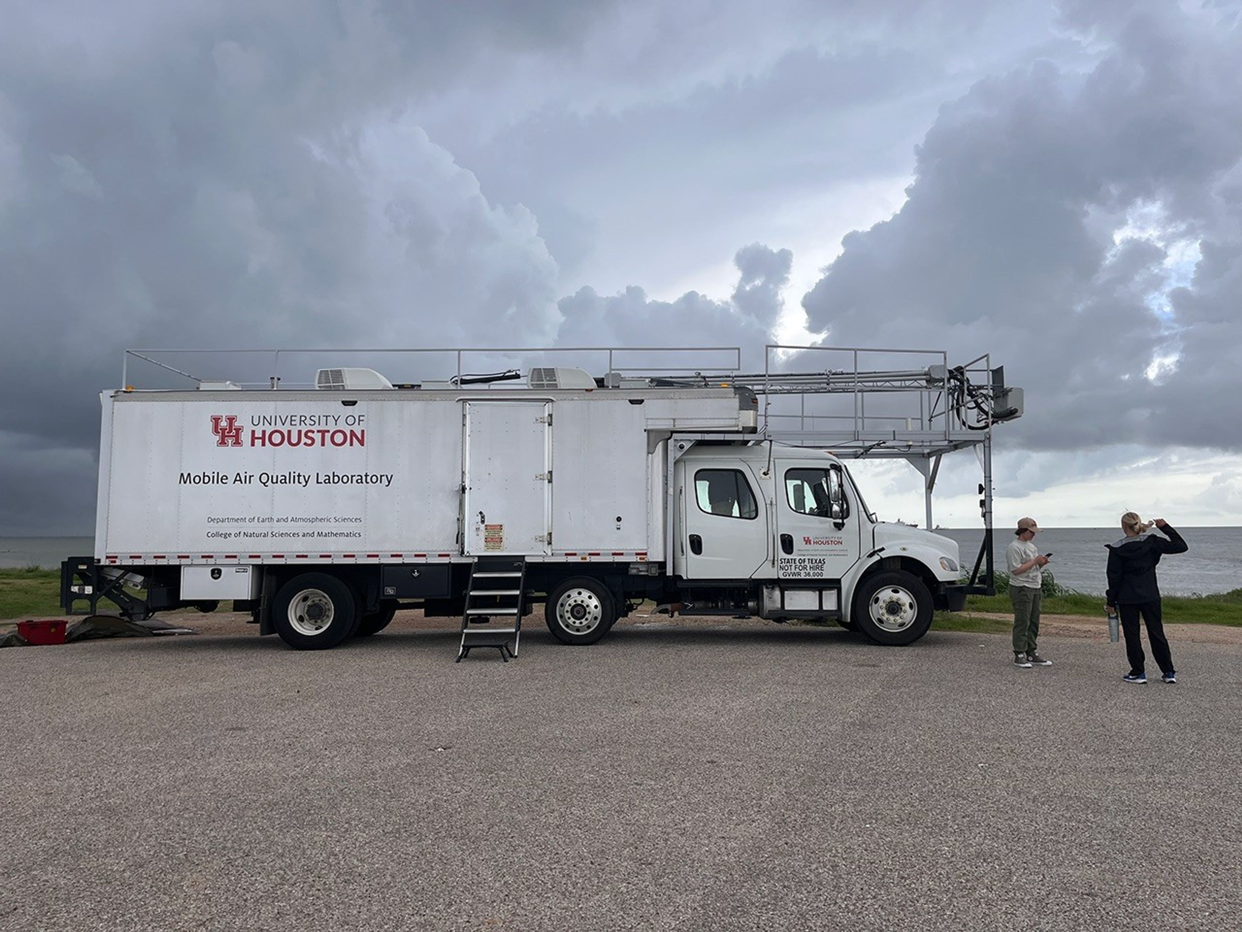
With the support of program mentors and faculty, and aboard the University of Houston’s Mobile Air Quality Laboratory (MAQL), the SARP interns participated in every step of the process.  

A large white truck is centered in the image. Stairs lead up to the back end of the truck, up to a currently closed door. The truck has a label on the back saying “University of Houston Mobile Air Quality Laboratory”. Two people are standing to the right of the image. Dark clouds billow in the background of the image.
The Mobile Air Quality Laboratory (MAQL) stands ready for some fieldwork.
NASA/Erica McNamee

Let’s set the scene: About 45 minutes away from this year’s SARP home base at the Lone Star Flight Museum in Houston, the MAQL drove down the Texas City Dike, a long strip of land jutting into the Texas Gulf Coast—an open space perfect for releasing the weather balloon. Among the 45 total students in the program, this group was assigned to meet the mobile lab at the balloon release location at  8 a.m. Central Time, just after a rainstorm rolled through. 

Inside the lab, the students prepared ozonesondes for takeoff, completing the final steps that include measuring and pipetting cathode and anode solutions into the instrument cells attached to the sensor and testing each instrument’s response and baseline. 

Outside the mobile laboratory, gusts of wind made it difficult to keep the balloon still while it was being filled with helium. Four students donned leather gloves to minimize oils from their fingers touching the balloon, which can make it pop faster after deployment. They wrangled the balloon while faculty advisor Travis Griggs, instructional assistant professor of atmospheric science from the University of Houston, filled it.  

The center of the image shows a large white balloon. Beneath the balloon are five people in a circle, gently holding at the bottom of the balloon to keep it upright. In the background of the image, other people watch.
SARP students prepare the weather balloon for takeoff by filling it up with helium, while making sure it doesn’t pop or fly away.
NASA/Sofie Bates

Five students worked together to keep the balloon from flying away as they strung it to the ozonesonde, protected in a small foam container. 

After confirming the launch location, time, and expected flight path with the Federal Aviation Administration (just a phone call away), it was time to set the weather instrument free.   

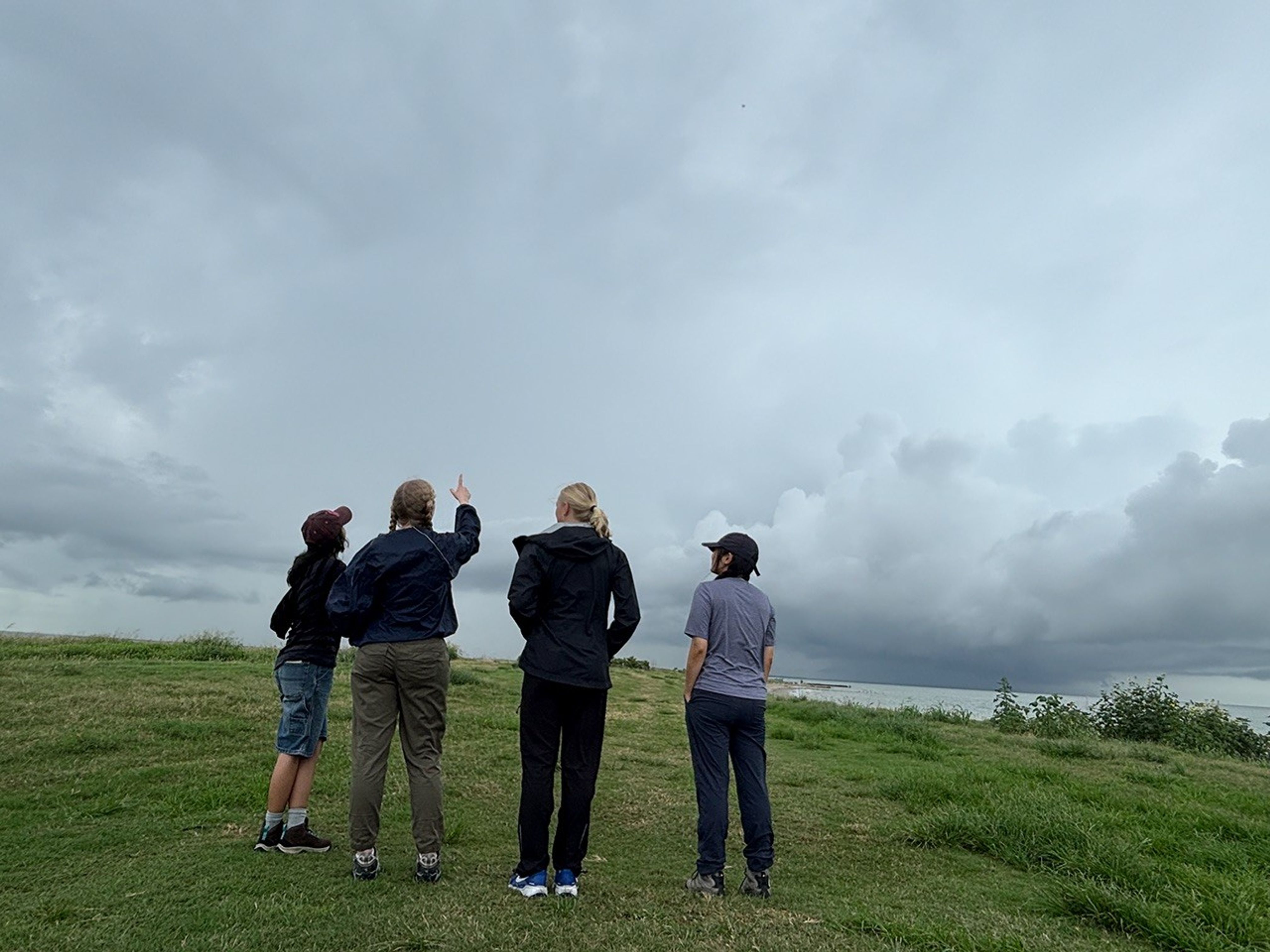
Four students stand in a line centered in the image facing away from the camera. They’re looking up at the sky — a dark and cloud filled sky — and standing on dark green grass. One student, second from the left, points up at the sky.
Even though it’s hard to see, there’s a tiny dot up in the sky—that’s the weather balloon! These students are admiring their work, watching their science experiment float up into the atmosphere to collect data.
NASA/Sofie Bates

“It was like a fight to stay on the ground, with the balloon whipping around in the wind,” said Zayna Haider, SARP intern and atmospheric and climate science student from the University of Washington. “It just flew away as soon as we let it go.” 

But the work had only just begun. The students huddled back inside the MAQL, monitoring data as long as the balloon kept sending it—until it popped or landed, whichever came first. Throughout the day, they repeated this process with two other balloons.  

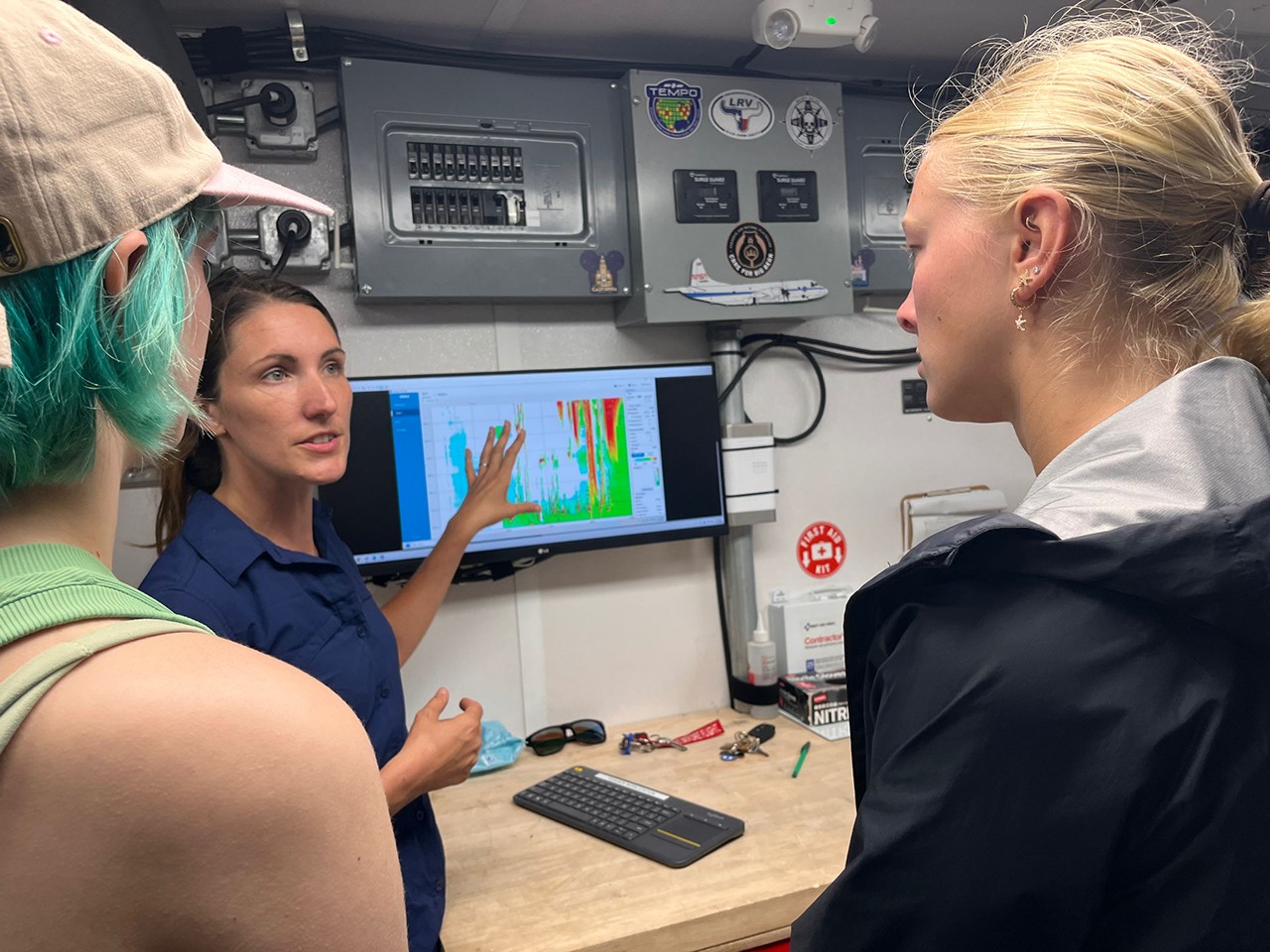
In the background of the image is a computer screen showing science data in green, orange, and red colors. Two students, in the foreground of the image, are looking at the screen, while a woman stands in front of it, looking at the students and pointing at the screen.
Students inside the Mobile Air Quality Laboratory reviewed the data from the weather balloon they had just launched.
NASA/Erica McNamee

This day gave many SARP participants, just starting their science careers, their first glimpse at hands-on fieldwork that reached the edges of the atmosphere. Next, they would use this data and what they learned from the experience for their end-of-internship research presentation.  

“This is beyond what I ever thought it could be,” Stevens said. “I’m super excited for the next seven weeks.” 

The post Up, Up, and Away With Weather Balloons  appeared first on NASA Science.

❌