 Login
Vesuvius Eruption Turned This Roman Man’s Brain Into Glass 2,000 Years Ago. Scientists Now Know How It Happened
24 June 2026 at 11:44
 A deadly ash cloud preserved the man's brain as glass for thousands of years.

 A deadly ash cloud preserved the man's brain as glass for thousands of years.
Where is it? La Palma, Canary Islands, Spain [28.62120467, -17.89960469]
What's in the photo? Concentric cloud rings over an erupting volcano
Which satellite took the photo? NASA's Aqua satellite
When was it taken? Oct. 1, 2021
This eye-catching satellite snap shows off a "bull's-eye-like" set of concentric cloud rings that formed above an erupting volcano on La Palma in Spain's Canary Islands.
The eruption, the first on La Palma in 50 years, began Sept. 19, 2021, when a fissure opened up on the western flank of Cumbre Vieja — a volcanic ridge that runs through the southern half of the island — and spewed massive lava fountains into the air. The violent outburst created a 660-foot-tall (200 meters) vent, dubbed Tajogaite, which continued to slowly pump out lava until Dec. 13, 2021.
The molten rock flowed into the Atlantic Ocean in a giant "river of fire" that destroyed a town and unleashed deadly gases that are still causing issues for locals today, Live Science previously reported.
The concentric cloud rings in this image are made up of steam, smoke and ash — known as an eruption plume — that rose above Tajogaite for weeks.
Normally, such a plume would continue to climb into the cold air of the stratosphere — the second layer of the atmosphere, which extends from around 6 to 31 miles (10 to 50 kilometers) above Earth's surface. However, when this image was captured, a rare "temperature inversion" created a layer of elevated warm air that acted as a lid, preventing the plume from rising and forcing it to spread outward, according to NASA's Earth Observatory.
The trapped plume created concentric rings that formed from the natural ebb and flow in the intensity of volcanic activity. This pulse in the emissions given off by the volcano is visible in time-lapse footage captured by the Izaña Atmospheric Research Center on Tenerife, another Canary Island.
The official name for this type of concentric cloud formation is a "gravity wave," according to the National Weather Service. However, the formation has nothing to do with gravity, and it's completely separate from the ripples in space-time called gravitational waves.
During the 85-day eruption, around 7.1 billion cubic feet (200 million cubic meters) of lava — reaching temperatures of up to 2,000 degrees Fahrenheit (1,100 degrees Celsius) — seeped from the ground.
This molten rock traveled around 4 miles (6.4 kilometers), destroying around 3,000 buildings in the town of Todoque, before falling into the Atlantic Ocean in a fiery waterfall. The estimated damage exceeded 700 million euros ($780 million), according to the Spanish newspaper El País.
Where lava fell into the sea, around 4.6 million square feet (430,000 square meters) of new land was created. The reaction between the molten rock and the water also released high levels of volcanic gases, such as sulfur dioxide and hydrogen cyanide.
At least one person, a 72-year-old man who returned to his home prematurely, is believed to have died from inhaling these toxic fumes, according to AFP. Thousands of wild and agricultural animals are also thought to have been killed by the gases.
The damage was "truly terrible," Marie Edmonds, a volcanologist at the University of Cambridge, told Live Science at an event on La Palma in April 2025. "Most shocking to me is the closeness of the vent to the communities," she added when describing what it was like to visit the area. "It must have been absolutely terrifying to see the eruption so close."
Indonesia's 'Twin Peaks' volcanoes
A 2021 astronaut photo shows the surprising similarities between Mount Sundoro and Mount Sumbing, which lie at the heart of Java, Indonesia.
Russian volcano sprouts 'devil horns'
A false-color satellite photo from 2023 shows a devilish pair of lava flows and an enormous plume of smoke spewing from Klyuchevskoy, the tallest volcano in Europe and Asia.
Nicaragua's volcanic 'googly eyes'
A 2014 astronaut photo shows a pair of volcanic lakes appearing to stare up into space from the Chiltepe Peninsula of Nicaragua's Lake Managua. These "eyes" and "skull" were created by violent eruptions thousands of years ago.
Where is it? Central Java, Indonesia [-7.34485373, 110.02748950]
What's in the photo? Mount Sundoro (left) and Mount Sumbing (right)
Who took the photo? An unnamed astronaut on board the International Space Station
When was it taken? May 10, 2021
This awesome astronaut photo shows the striking symmetry of "twin" stratovolcanoes at the heart of Java, Indonesia. The parallel peaks are an eye-catching reminder of the region's extreme tectonic activity.
Mount Sundoro (also known as Sindoro or Sindara) on the left of the image, reaches a maximum height of 10,331 feet (3,149 meters). Its partner, Mount Sumbing, sits to the southeast (on the right of the image) and is slightly taller, at 11,056 feet (3,370 m) above sea level.
Both are considered active. Although Sumbing has not erupted since 1730, Sundoro has blown its top more recently, in 1971, and has experienced seismic activity as recently as 2012, according to the Smithsonian Institution's Global Volcanism Program.
The volcanoes' peaks are just 7.5 miles (12 kilometers) apart. A raised ridge with a major highway runs perpendicularly between them.
Each volcano also has a smaller, secondary cone on its flank left over from previous eruptions (to the upper left of Sundoro and the upper right of Sumbing in the image), and their orientations make the volcanoes look like mirror images of each other.
The slopes of both cones are covered with rings of dark-green forest that sharply terminate at their bases. The volcanic soils surrounding the mountains are excellent for growing crops such as rice, corn, coffee and sugarcane, which has led to the deforestation of their surroundings, according to NASA's Earth Observatory.
This matching coloration accentuates the similarities between the pair, especially when viewed from above.
One of the few differences between Sundoro and Sumbing is that the latter volcano has a sizable crater at its summit, which was carved out by the 1730 eruption. As a result, the larger volcano appears to have a darker point at its top.
The volcanoes are commonly referred to as "twins," due to their near-identical profiles. However, local people often call them "husband and wife," according to a local travel site. In this narrative, Sumbing is considered the husband due to its slight height advantage and "more masculine" profile.
Sundoro and Sumbing are part of the wider Dieng Volcanic Complex, which consists of around 20 volcanic cones stretching across central Java. Indonesia is also positioned along the "Ring of Fire," a roughly horseshoe-shaped arc of volcanoes that runs along a series of tectonic plate boundaries encircling the Pacific Ocean.
Over the past few years, there have been a number of significant eruptions in Indonesia, including a pair of violent blasts at Mount Lewotobi Laki-laki, on Flores Island, in 2024 and 2025. As of June 2026, there are seven ongoing eruptions in Indonesia — the most of any nation.
Rocky rings wear a 'magma hat'
A 2025 astronaut photo shows a massif made of concentric mountain ridges in the Libyan desert. The rocky walls contain ancient artworks.
Trio of black mesas in Sahara
A 2023 astronaut photo shows three dark hills, or mesas, towering above southern Mauritania. The structures are remnants of a single Paleozoic-era formation.
Glowering 'skull' in volcanic pit
A 2023 astronaut photo shows off an unusual cranium-like structure appearing to stare up into space from the floor of a large volcanic caldera in Chad.
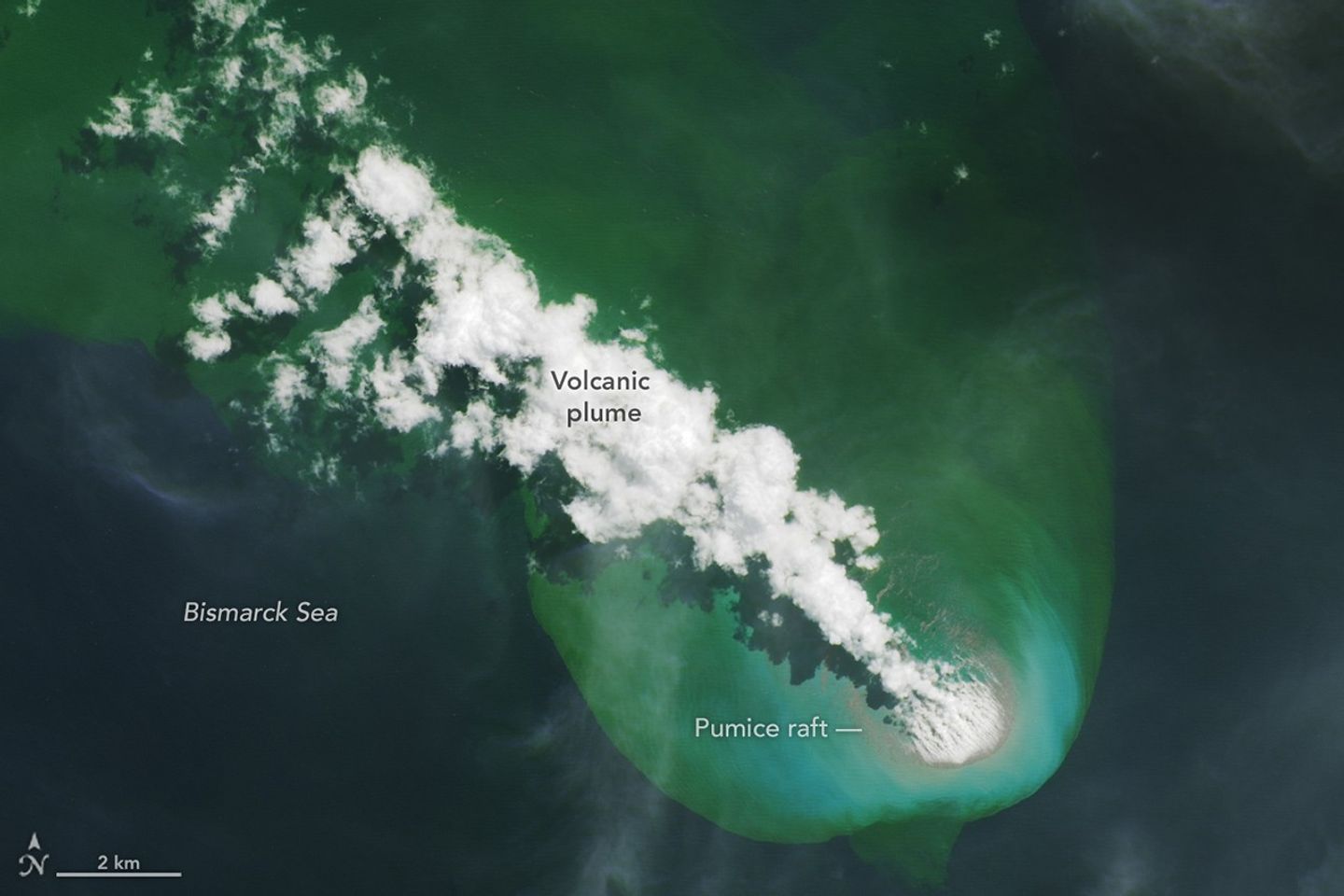
On May 8, 2026, satellites detected signs of an unexpected submarine volcanic eruption in the Bismarck Sea near the islands of Papua New Guinea. Over the next several weeks, plumes of steam and ash streamed over the sea, and areas of discolored water surrounded the eruption site. Relatively little is known about the ocean floor in this area or the volcanic feature that is presently erupting. But experts think the new activity, ongoing as of mid-June, might be occurring along the Titan Ridge and has the potential to form an ephemeral new island.
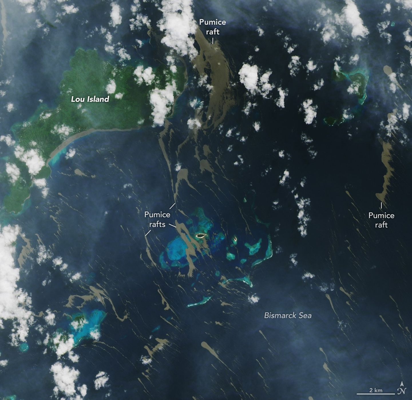
Despite the unknowns, the effects of the eruption became unmistakable for some communities in Papua New Guinea’s Admiralty Islands. In early June, rafts of pumice drifted northwest from the eruption site and clogged up coastlines on several of the islands. Bands of the buoyant volcanic material are visible in this image, acquired with the OLI (Operational Land Imager) on Landsat 8 on June 4, as they drifted with surface currents on the Bismarck Sea.
Several days after the image, news outlets reported acute impacts from thick masses of pumice reaching coastal areas. Communities on Lou Island and Baluan Island, to the south, were described by officials as among the worst affected, according to reports from local media. Outlets reported that a layer of pumice up to several meters thick blanketed the shore, cutting off access to the water. The volcanic fragments similarly choked the coast and key waterways around the much larger Manus Island, about 125 kilometers (80 miles) northwest of the volcano and out of frame.
Studies of past pumice raft events have found that the material can remain afloat for months to years before sinking out of satellite view. Larger rafts can form with the help of ash, which serves to “weld” together fragments of the porous rock, said Jim Garvin, the chief scientist at NASA’s Goddard Space Flight Center, noting this process occurred during the 2022 eruption of Hunga Tonga-Hunga Ha‘apai. “These masses can pile up around erupting vents to protect the eruption centers and produce ephemeral new lands in some cases,” he said. When adrift, such pumice platforms can act as floating homes for marine organisms—from microalgae to bryozoans to barnacles—and enable them to disperse over long distances.
Though beneficial to life in some ways, the rafts can pose serious threats to humans and other species. Some of the larger fragments of pumice stack up to form ridges when they reach the coastlines of islands. Reports from Papua New Guinea highlight the disruptions to fishing, the transport of goods, and access to critical services that can occur when pumice accumulates along the coast.
Communities have expressed concerns over the pumice’s effects on marine ecosystems, as well. Researchers have noted that the sustained presence of pumice can block sunlight and may inhibit photosynthesis in seagrass and corals below, and the rocks may physically damage reef structures. In a review of the ecological effects of pumice reaching Japan’s coast in 2021, researchers noted the die-off of filter-feeding fish in fishery cages from ingesting pumice, warning that other wildlife may be harmed by mistakenly consuming the rocks.
New studies using an ensemble of orbital remote sensing platforms—including Landsat, hyperspectral instruments, and imaging radars—are tracking developments in this Bismarck Sea region, Garvin said. These observations can provide new perspectives on hazards as well as unique scientific opportunities for improved understanding of submarine eruptions.
NASA Earth Observatory images by Lauren Dauphin, using Landsat data from the U.S. Geological Survey. Story by Lindsey Doermann.
Stay up-to-date with the latest content from NASA as we explore the universe and discover more about our home planet.
Satellite imagery shows a surge of new volcanic activity in the ocean near Papua New Guinea.
The Tongan volcano expanded its mid-Pacific real estate during its latest eruptive phase.
Episode 43 of the Hawaiian volcano’s current eruption was marked by high lava fountains and widespread ash dispersal.
Subscribe to the Earth Observatory and get the Earth in your inbox.
NASA’s Earth Observatory brings you the Earth, every day, with in-depth stories and stunning imagery.
Explore Earth Science
Open access to NASA’s archive of Earth science data
On May 8, 2026, satellites detected signs of an unexpected submarine volcanic eruption in the Bismarck Sea near the islands of Papua New Guinea. Over the next several weeks, plumes of steam and ash streamed over the sea, and areas of discolored water surrounded the eruption site. Relatively little is known about the ocean floor in this area or the volcanic feature that is presently erupting. But experts think the new activity, ongoing as of mid-June, might be occurring along the Titan Ridge and has the potential to form an ephemeral new island.
Despite the unknowns, the effects of the eruption became unmistakable for some communities in Papua New Guinea’s Admiralty Islands. In early June, rafts of pumice drifted northwest from the eruption site and clogged up coastlines on several of the islands. Bands of the buoyant volcanic material are visible in this image, acquired with the OLI (Operational Land Imager) on Landsat 8 on June 4, as they drifted with surface currents on the Bismarck Sea.
Several days after the image, news outlets reported acute impacts from thick masses of pumice reaching coastal areas. Communities on Lou Island and Baluan Island, to the south, were described by officials as among the worst affected, according to reports from local media. Outlets reported that a layer of pumice up to several meters thick blanketed the shore, cutting off access to the water. The volcanic fragments similarly choked the coast and key waterways around the much larger Manus Island, about 125 kilometers (80 miles) northwest of the volcano and out of frame.
Studies of past pumice raft events have found that the material can remain afloat for months to years before sinking out of satellite view. Larger rafts can form with the help of ash, which serves to “weld” together fragments of the porous rock, said Jim Garvin, the chief scientist at NASA’s Goddard Space Flight Center, noting this process occurred during the 2022 eruption of Hunga Tonga-Hunga Ha‘apai. “These masses can pile up around erupting vents to protect the eruption centers and produce ephemeral new lands in some cases,” he said. When adrift, such pumice platforms can act as floating homes for marine organisms—from microalgae to bryozoans to barnacles—and enable them to disperse over long distances.
Though beneficial to life in some ways, the rafts can pose serious threats to humans and other species. Some of the larger fragments of pumice stack up to form ridges when they reach the coastlines of islands. Reports from Papua New Guinea highlight the disruptions to fishing, the transport of goods, and access to critical services that can occur when pumice accumulates along the coast.
Communities have expressed concerns over the pumice’s effects on marine ecosystems, as well. Researchers have noted that the sustained presence of pumice can block sunlight and may inhibit photosynthesis in seagrass and corals below, and the rocks may physically damage reef structures. In a review of the ecological effects of pumice reaching Japan’s coast in 2021, researchers noted the die-off of filter-feeding fish in fishery cages from ingesting pumice, warning that other wildlife may be harmed by mistakenly consuming the rocks.
New studies using an ensemble of orbital remote sensing platforms—including Landsat, hyperspectral instruments, and imaging radars—are tracking developments in this Bismarck Sea region, Garvin said. These observations can provide new perspectives on hazards as well as unique scientific opportunities for improved understanding of submarine eruptions.
NASA Earth Observatory images by Lauren Dauphin, using Landsat data from the U.S. Geological Survey. Story by Lindsey Doermann.
Stay up-to-date with the latest content from NASA as we explore the universe and discover more about our home planet.
Satellite imagery shows a surge of new volcanic activity in the ocean near Papua New Guinea.
The Tongan volcano expanded its mid-Pacific real estate during its latest eruptive phase.
Episode 43 of the Hawaiian volcano’s current eruption was marked by high lava fountains and widespread ash dispersal.
Subscribe to the Earth Observatory and get the Earth in your inbox.
NASA's Earth Observatory brings you the Earth, every day, with in-depth stories and stunning imagery.
Explore Earth Science
Open access to NASA’s archive of Earth science data
The post Pumice Rafts Encroach on Admiralty Islands appeared first on NASA Science.

