❌

Normal view

NASA’s Moon Orbiter Spots New, ‘Once-in-Century’ Moon Crater

16 September 2026 at 19:06
6 Min Read

NASA’s Moon Orbiter Spots New, ‘Once-in-Century’ Moon Crater

Black-and-white image of a textured, cratered surface. Two black arrows near the center point inward toward a small, dark, circular feature.
A zoomed-in view of the Moon made from images from NASA’s Lunar Reconnaissance Orbiter Camera. (More information at the bottom of article.)
Credits: NASA Goddard/Intuitive Machines/Robert Wagner

It started as a routine data-quality check. But as Robert Wagner, a scientist with NASA’s Lunar Reconnaissance Orbiter (LRO), scanned a giant Moon map on his computer screen, an unusually large bright spot circled by a dark halo caught his eye, as it implied that surface material in that area had been shaken up.

“I just stopped, dropped everything, and started looking into what that spot was,” said Wagner, an image-processing specialist from Intuitive Machines who works with data from the Lunar Reconnaissance Orbiter Camera (LROC) system.

By comparing before and after images of the Moon, Wagner realized he had discovered the largest, newly formed crater ever found in the solar system, as scientists reported Wednesday in Science Advances. This discovery highlights the value of NASA’s Moon orbiter data in studying a dynamic landscape as the agency advances a sustained human presence and expanded scientific and commercial activity on the Moon.
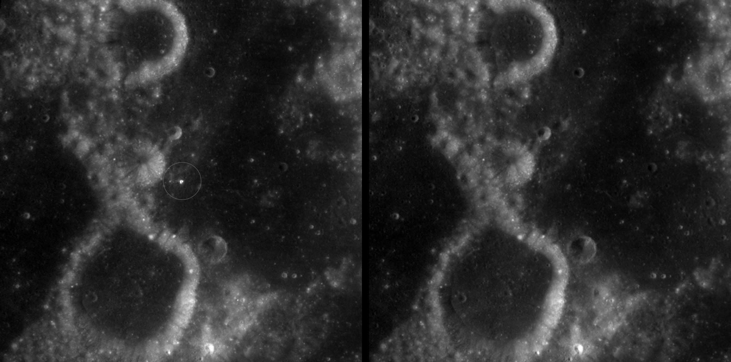
Two nearly identical black-and-white images appear side by side, separated by a vertical black line. Each shows a dark, uneven surface with scattered small circular depressions and several larger round formations with bright, raised rims. In the left image, a thin white circle marks a small, white spot near the center; there is no circled, white spot in the the corresponding area in the right image.
A zoomed-in view of McGetchin crater, circled on the left, next to a “before” image on the right. The panel on the left is made from images captured by NASA’s Lunar Reconnaissance Orbiter Wide-Angle Camera in summer 2025; the right panel was made from images taken in spring 2011. The white spot is not the crater itself, but rather material flung out of the crater, which formed when a rock, possibly this size of a three- to six‑story building, crashed into the Moon between April 11 and May 22, 2024 – a once-in-a-century event, as scientists reported on Sept. 15, 2026, in a pair of papers in Science Advances. The area shown in the images is 38 miles wide.
NASA Goddard/Intuitive Machines/Robert Wagner

Officially named McGetchin after pioneering lunar scientist Tom McGetchin, the crater formed on the Moon’s eastern edge sometime between April 11 and May 22, 2024, after a comet or asteroid the size of a three- to six-story building hit the surface.
 
The crash left a crater, 728 feet wide, that spans the length of two football fields. And at 141 feet deep, the crater could fit three vertically stacked yellow school buses.
 
Scientists estimate that an impact of this magnitude happens on the Moon about once in a century or even longer.

Moon takes some hits

For more than 17 years, LRO has been circling the Moon and using its seven instruments to map the topography, surface composition, temperature, and radiation environment there. The spacecraft’s team has identified at least 1,000 new impact craters throughout the mission and flagged 100,000 more surface changes from an object smashing into the Moon or from the debris that flung out after.

With no atmosphere to slow them or burn them up, space rocks and other objects easily reach the lunar surface. Most are much smaller compared to the object that carved out McGetchin crater. The smallest craters scientists can distinguish from LRO images are about 30 feet wide, the length of a three-story building laid on its side, made by rocks about 43 inches wide, the size of a monster-truck tire. Scientists estimate that impacts of this scale produce about 140 new craters across the Moon each year. But most new ones are made by microscopic projectiles that leave holes too small to identify in orbital images.

With its numerous instruments, the spacecraft can observe changes to the lunar surface that aren’t apparent in the LROC images alone. After the crater was discovered, scientists working with LRO’s thermal instrument, Diviner, made follow-up observations of the site. They found a 4-mile-wide area around the crater that is about 16 degrees Fahrenheit cooler at night than its surroundings.
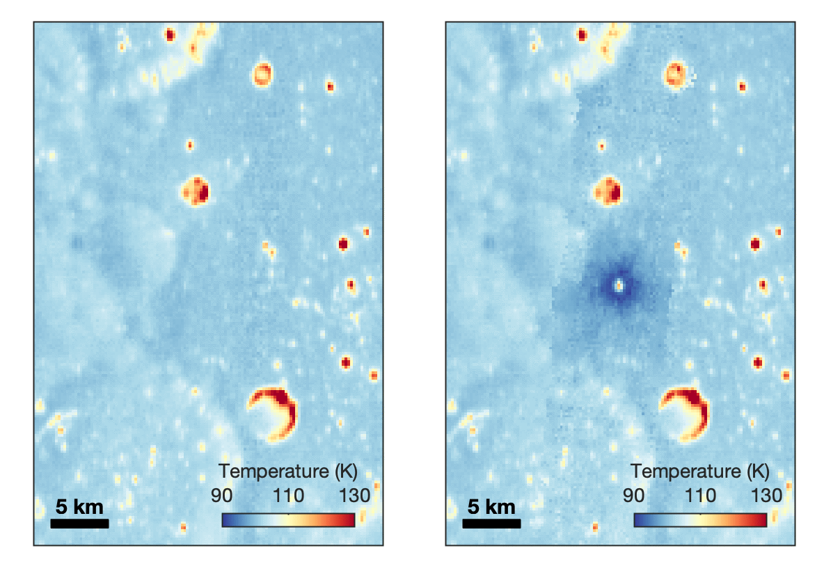
Animated temperature map that alternates between two images. A vertical strip through the center blinks on and off, revealing a dark blue circular area surrounding a small white spot near the middle. The pale blue map also contains scattered yellow, orange, and red spots and rings, including a large, curved red-and-yellow feature near the lower center. A 5-kilometer scale bar appears at lower left, and a color key ranges from 90 kelvin in dark blue to 130 kelvin in dark red.
This animated image set shows an area on the eastern limb of the Moon before and after McGetchin crater formed there sometime between April 11 and May 22, 2024. The post-impact image was constructed using data taken by NASA’s Lunar Reconnaissance Orbiter (LRO) thermal instrument, Diviner, between Nov. 15, 2025, and Feb. 18, 2026, after scientists discovered the crater in visible-light images taken by LRO’s Wide-Angle Camera. Pre-impact temperatures are from the Diviner Global High-Resolution Mosaics (GHRM). The crater formed on the Moon after a comet or asteroid, possibly the size of a six-story building, hit the surface in a rare, once-in-a-century collision. The dark blue strip that flashes into view reveals a 4-mile-wide “cold spot” around the crater that is about 16 degrees Fahrenheit cooler at night than its surroundings. This cooling happens because an impact fluffs up regolith around a crater, making it less dense and therefore less able to retain heat. Scientists on the Diviner team reported this finding in a paper published on Sept. 16, 2026, in Science Advances. The red and yellow spots indicate areas typically associated with rocks excavated by long-ago impacts which, though still at cryogenic temperatures like their surroundings, remain slightly warmer at night.
NASA Goddard/UCLA/JHU APL

Reporting in a second paper Wednesday in the same journal, researchers say that the cooling happens because the impact fluffs up the regolith around the crater, making it less dense and therefore less able to retain heat.

The large extent of this “cold spot” is striking, scientists say, because it shows that impacts can modify the Moon’s surface far beyond the crater itself. These physical changes could affect how rover wheels interact with the surface, for instance.
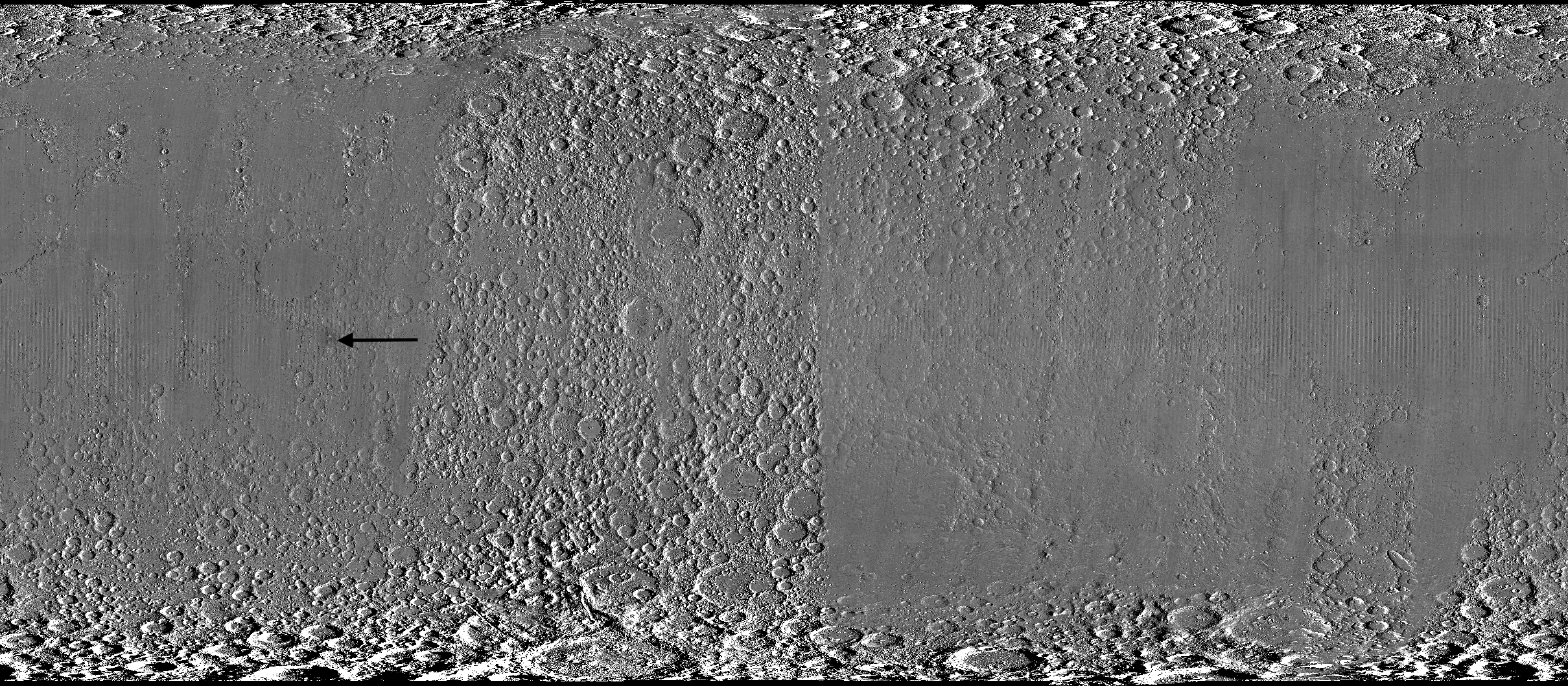
Wide black-and-white image of a rough, uneven surface densely covered with circular depressions and raised areas. The upper and lower edges are especially rugged, while the center is smoother and divided by subtle vertical bands. A black arrow left of center points toward a faint, narrow vertical mark.
A global view of the Moon made by stitching together hundreds of images from the Wide-Angle Camera aboard NASA’s Lunar Reconnaissance Orbiter (LRO). Robert Wagner, image processing specialist for LRO, made this map using two sets of mages taken several years apart. He used a software designed to highlight any changes between the two sets. Anything that stayed the same turned gray; anything different showed up as bright or dark patches. A black arrow just left of center points to McGetchin crater.
NASA Goddard/Intuitive Machines/Robert Wagner

Road to discovery

The LROC system collects images from about 60 miles above the Moon as LRO loops from pole to pole. The system includes two cameras that capture high‑resolution black‑and‑white images and one camera for moderate‑resolution multispectral images. Over the years and thousands of passes, scientists have built maps detailed enough to spot not only new craters, but also landslides, landers, seismic faults, and even hints of lava tubes.

LROC scientists regularly analyze close-up images of small portions of the Moon’s surface taken by the Narrow-Angle Camera. Using these images, they look for changes that are typically less than 30 feet across. But every few years the team searches for large (wider than 150 feet) features by creating global Moon maps and comparing them to older versions.

Square black-and-white image of a dark, uneven surface. At the center is a dark, roughly circular depression surrounded by a bright irregular area, with long streaks of lighter material radiating outward in all directions.
An overhead, close-up view of McGetchin crater that was taken on Dec. 5, 2025, by NASA’s Lunar Reconnaissance Orbiter (LRO) Narrow-Angle Camera (NAC). After the crater was discovered on Oct. 24, 2025, in global images from LRO’s Wide-Angle Camera, which captures broad views with pixels the size of American football fields, scientists turned to the NAC, which takes much sharper views at about 3 feet per pixel. The NAC images, taken as LRO flew over the impact site again, revealed the crater size, shape, and how the surrounding terrain was affected by the impact that carved McGetchin. The image covers an area that’s ¾ mile wide.
NASA Goddard/Intuitive Machines
Square black-and-white image of a dark, gently uneven surface scattered with small circular depressions. Near the center is a small oval crater with a bright raised rim and dark interior. Fine, bright streaks radiate outward from the crater across the surrounding surface.
This view from the side (55° away from straight down) towards the east, covers an area of the Moon that’s about 1.5 miles wide. It was taken by NASA’s Lunar Reconnaissance Orbiter Narrow-Angle Camera on March 3, 2026.
NASA Goddard/Intuitive Machines

That’s what Wagner was doing on Oct. 24, 2025, when he came across McGetchin. Using images from LROC’s Wide-Angle Camera, which captures broad views with pixels the size of football fields, he stacked hundreds of “before” and “after” frames with software designed to highlight change. Anything that stayed the same turned gray while anything different showed up as bright or dark patches.

While the process sounds straightforward, spotting real craters requires a lot of manual work. The software flags every tiny shift in lighting or shadow, generating hundreds of false alarms. For this reason, Wagner typically verifies the software, looking for small fuzzy halos around pixel‑wide bright points, which indicate splashes of regolith around a new crater.

Spanning hundreds of pixels, McGetchin stood out immediately. “It was by far the most obvious impact debris pattern I’ve ever seen in one of these images,” Wagner said.

After his discovery, scientists turned to the Narrow-Angle Camera, which takes much sharper views at about 3 feet per pixel. This camera’s close-up images, taken as LRO flew over the impact site again, revealed the crater size, shape, and how the surrounding terrain was affected. These images also helped researchers estimate the size and force of the rock fragment that formed the new crater, details that are expected to appear in a future paper.

Banner image caption: A zoomed-in view of the Moon, with debris around McGetchin crater visible as a white spot circled by a dark halo just right of center of the image (marked with black arrows). This is the view that Robert Wagner saw on Oct. 24, 2025, during a routine data-quality check. Wagner is an image processing specialist for NASA’s Lunar Reconnaissance Orbiter Camera, a system of three cameras. Using images from the Wide-Angle Camera (WAC), which captures broad views with pixels the size of American football fields, he stacked hundreds of images captured by WAC over the last several years with software designed to highlight change. Anything that stayed the same is gray; anything that changed showed up as bright or dark patches. The stripes in the image are due to slight changes in lighting between the older and newer images. This image composite shows an area of the Moon approximately 900 miles across.

About the Author

Lonnie Shekhtman

Lonnie Shekhtman

Senior Science Writer

Shekhtman helps communicate NASA planetary science to the world through news and feature stories on NASA.gov, videos for NASA+ and YouTube, and by working with the media. She reports on lunar and Mars science and exploration; NASA's search for life; missions to Venus, Titan, and Jupiter's Trojan asteroids; and many other topics related to NASA's exploration of our solar system and beyond.

Keep Exploring

Discover More Topics From NASA

Simplified Summary

Scientists discovered a crater on the Moon that formed sometime between April 11 and May 22, 2024, after a comet or asteroid the size of a three- to six-story building hit the surface.   The crash left a crater, 728 feet wide, that spans the length of two football fields. And at 141 feet deep, the crater could fit three vertically stacked yellow school buses.

The post NASA’s Moon Orbiter Spots New, ‘Once-in-Century’ Moon Crater appeared first on NASA Science.

NASA’s Moon Orbiter Spots New, ‘Once-in-Century’ Moon Crater

16 September 2026 at 19:06
6 Min Read

NASA’s Moon Orbiter Spots New, ‘Once-in-Century’ Moon Crater

Black-and-white image of a textured, cratered surface. Two black arrows near the center point inward toward a small, dark, circular feature.
A zoomed-in view of the Moon made from images from NASA’s Lunar Reconnaissance Orbiter Camera. (More information at the bottom of article.)
Credits:
NASA Goddard/Intuitive Machines/Robert Wagner

It started as a routine data-quality check. But as Robert Wagner, a scientist with NASA’s Lunar Reconnaissance Orbiter (LRO), scanned a giant Moon map on his computer screen, an unusually large bright spot circled by a dark halo caught his eye, as it implied that surface material in that area had been shaken up.

“I just stopped, dropped everything, and started looking into what that spot was,” said Wagner, an image-processing specialist from Intuitive Machines who works with data from the Lunar Reconnaissance Orbiter Camera (LROC) system.

By comparing before and after images of the Moon, Wagner realized he had discovered the largest, newly formed crater ever found in the solar system, as scientists reported Wednesday in Science Advances. This discovery highlights the value of NASA’s Moon orbiter data in studying a dynamic landscape as the agency advances a sustained human presence and expanded scientific and commercial activity on the Moon.

Two nearly identical black-and-white images appear side by side, separated by a vertical black line. Each shows a dark, uneven surface with scattered small circular depressions and several larger round formations with bright, raised rims. In the left image, a thin white circle marks a small, white spot near the center; there is no circled, white spot in the the corresponding area in the right image.
A zoomed-in view of McGetchin crater, circled on the left, next to a “before” image on the right. The panel on the left is made from images captured by NASA’s Lunar Reconnaissance Orbiter Wide-Angle Camera in summer 2025; the right panel was made from images taken in spring 2011. The white spot is not the crater itself, but rather material flung out of the crater, which formed when a rock, possibly this size of a three- to six‑story building, crashed into the Moon between April 11 and May 22, 2024 – a once-in-a-century event, as scientists reported on Sept. 15, 2026, in a pair of papers in Science Advances. The area shown in the images is 38 miles wide.
NASA Goddard/Intuitive Machines/Robert Wagner

Officially named McGetchin after pioneering lunar scientist Tom McGetchin, the crater formed on the Moon’s eastern edge sometime between April 11 and May 22, 2024, after a comet or asteroid the size of a three- to six-story building hit the surface.
 
The crash left a crater, 728 feet wide, that spans the length of two football fields. And at 141 feet deep, the crater could fit three vertically stacked yellow school buses.
 
Scientists estimate that an impact of this magnitude happens on the Moon about once in a century or even longer.

Moon takes some hits

For more than 17 years, LRO has been circling the Moon and using its seven instruments to map the topography, surface composition, temperature, and radiation environment there. The spacecraft’s team has identified at least 1,000 new impact craters throughout the mission and flagged 100,000 more surface changes from an object smashing into the Moon or from the debris that flung out after.

With no atmosphere to slow them or burn them up, space rocks and other objects easily reach the lunar surface. Most are much smaller compared to the object that carved out McGetchin crater. The smallest craters scientists can distinguish from LRO images are about 30 feet wide, the length of a three-story building laid on its side, made by rocks about 43 inches wide, the size of a monster-truck tire. Scientists estimate that impacts of this scale produce about 140 new craters across the Moon each year. But most new ones are made by microscopic projectiles that leave holes too small to identify in orbital images.

With its numerous instruments, the spacecraft can observe changes to the lunar surface that aren’t apparent in the LROC images alone. After the crater was discovered, scientists working with LRO’s thermal instrument, Diviner, made follow-up observations of the site. They found a 4-mile-wide area around the crater that is about 16 degrees Fahrenheit cooler at night than its surroundings.

Animated temperature map that alternates between two images. A vertical strip through the center blinks on and off, revealing a dark blue circular area surrounding a small white spot near the middle. The pale blue map also contains scattered yellow, orange, and red spots and rings, including a large, curved red-and-yellow feature near the lower center. A 5-kilometer scale bar appears at lower left, and a color key ranges from 90 kelvin in dark blue to 130 kelvin in dark red.
This animated image set shows an area on the eastern limb of the Moon before and after McGetchin crater formed there sometime between April 11 and May 22, 2024. The post-impact image was constructed using data taken by NASA’s Lunar Reconnaissance Orbiter (LRO) thermal instrument, Diviner, between Nov. 15, 2025, and Feb. 18, 2026, after scientists discovered the crater in visible-light images taken by LRO’s Wide-Angle Camera. Pre-impact temperatures are from the Diviner Global High-Resolution Mosaics (GHRM). The crater formed on the Moon after a comet or asteroid, possibly the size of a six-story building, hit the surface in a rare, once-in-a-century collision. The dark blue strip that flashes into view reveals a 4-mile-wide “cold spot” around the crater that is about 16 degrees Fahrenheit cooler at night than its surroundings. This cooling happens because an impact fluffs up regolith around a crater, making it less dense and therefore less able to retain heat. Scientists on the Diviner team reported this finding in a paper published on Sept. 16, 2026, in Science Advances. The red and yellow spots indicate areas typically associated with rocks excavated by long-ago impacts which, though still at cryogenic temperatures like their surroundings, remain slightly warmer at night.
NASA Goddard/UCLA/JHU APL

Reporting in a second paper Wednesday in the same journal, researchers say that the cooling happens because the impact fluffs up the regolith around the crater, making it less dense and therefore less able to retain heat.

The large extent of this “cold spot” is striking, scientists say, because it shows that impacts can modify the Moon’s surface far beyond the crater itself. These physical changes could affect how rover wheels interact with the surface, for instance.

Wide black-and-white image of a rough, uneven surface densely covered with circular depressions and raised areas. The upper and lower edges are especially rugged, while the center is smoother and divided by subtle vertical bands. A black arrow left of center points toward a faint, narrow vertical mark.
A global view of the Moon made by stitching together hundreds of images from the Wide-Angle Camera aboard NASA’s Lunar Reconnaissance Orbiter (LRO). Robert Wagner, image processing specialist for LRO, made this map using two sets of mages taken several years apart. He used a software designed to highlight any changes between the two sets. Anything that stayed the same turned gray; anything different showed up as bright or dark patches. A black arrow just left of center points to McGetchin crater.
NASA Goddard/Intuitive Machines/Robert Wagner

Road to discovery

The LROC system collects images from about 60 miles above the Moon as LRO loops from pole to pole. The system includes two cameras that capture high‑resolution black‑and‑white images and one camera for moderate‑resolution multispectral images. Over the years and thousands of passes, scientists have built maps detailed enough to spot not only new craters, but also landslides, landers, seismic faults, and even hints of lava tubes.

LROC scientists regularly analyze close-up images of small portions of the Moon’s surface taken by the Narrow-Angle Camera. Using these images, they look for changes that are typically less than 30 feet across. But every few years the team searches for large (wider than 150 feet) features by creating global Moon maps and comparing them to older versions.

Square black-and-white image of a dark, uneven surface. At the center is a dark, roughly circular depression surrounded by a bright irregular area, with long streaks of lighter material radiating outward in all directions.
An overhead, close-up view of McGetchin crater that was taken on Dec. 5, 2025, by NASA’s Lunar Reconnaissance Orbiter (LRO) Narrow-Angle Camera (NAC). After the crater was discovered on Oct. 24, 2025, in global images from LRO’s Wide-Angle Camera, which captures broad views with pixels the size of American football fields, scientists turned to the NAC, which takes much sharper views at about 3 feet per pixel. The NAC images, taken as LRO flew over the impact site again, revealed the crater size, shape, and how the surrounding terrain was affected by the impact that carved McGetchin. The image covers an area that’s ¾ mile wide.
NASA Goddard/Intuitive Machines
Square black-and-white image of a dark, gently uneven surface scattered with small circular depressions. Near the center is a small oval crater with a bright raised rim and dark interior. Fine, bright streaks radiate outward from the crater across the surrounding surface.
This view from the side (55° away from straight down) towards the east, covers an area of the Moon that’s about 1.5 miles wide. It was taken by NASA’s Lunar Reconnaissance Orbiter Narrow-Angle Camera on March 3, 2026.
NASA Goddard/Intuitive Machines

That’s what Wagner was doing on Oct. 24, 2025, when he came across McGetchin. Using images from LROC’s Wide-Angle Camera, which captures broad views with pixels the size of football fields, he stacked hundreds of “before” and “after” frames with software designed to highlight change. Anything that stayed the same turned gray while anything different showed up as bright or dark patches.

While the process sounds straightforward, spotting real craters requires a lot of manual work. The software flags every tiny shift in lighting or shadow, generating hundreds of false alarms. For this reason, Wagner typically verifies the software, looking for small fuzzy halos around pixel‑wide bright points, which indicate splashes of regolith around a new crater.

Spanning hundreds of pixels, McGetchin stood out immediately. “It was by far the most obvious impact debris pattern I’ve ever seen in one of these images,” Wagner said.

After his discovery, scientists turned to the Narrow-Angle Camera, which takes much sharper views at about 3 feet per pixel. This camera’s close-up images, taken as LRO flew over the impact site again, revealed the crater size, shape, and how the surrounding terrain was affected. These images also helped researchers estimate the size and force of the rock fragment that formed the new crater, details that are expected to appear in a future paper.

Banner image caption: A zoomed-in view of the Moon, with debris around McGetchin crater visible as a white spot circled by a dark halo just right of center of the image (marked with black arrows). This is the view that Robert Wagner saw on Oct. 24, 2025, during a routine data-quality check. Wagner is an image processing specialist for NASA’s Lunar Reconnaissance Orbiter Camera, a system of three cameras. Using images from the Wide-Angle Camera (WAC), which captures broad views with pixels the size of American football fields, he stacked hundreds of images captured by WAC over the last several years with software designed to highlight change. Anything that stayed the same is gray; anything that changed showed up as bright or dark patches. The stripes in the image are due to slight changes in lighting between the older and newer images. This image composite shows an area of the Moon approximately 900 miles across.

About the Author

Lonnie Shekhtman

Lonnie Shekhtman

Senior Science Writer

Shekhtman helps communicate NASA planetary science to the world through news and feature stories on NASA.gov, videos for NASA+ and YouTube, and by working with the media. She reports on lunar and Mars science and exploration; NASA’s search for life; missions to Venus, Titan, and Jupiter’s Trojan asteroids; and many other topics related to NASA’s exploration of our solar system and beyond.

Keep Exploring

Discover More Topics From NASA

Simplified Summary

Scientists discovered a crater on the Moon that formed sometime between April 11 and May 22, 2024, after a comet or asteroid the size of a three- to six-story building hit the surface.
 
The crash left a crater, 728 feet wide, that spans the length of two football fields. And at 141 feet deep, the crater could fit three vertically stacked yellow school buses.

NASA Invites Media to International Observe the Moon Night

15 September 2026 at 19:55

NASA will host an International Observe the Moon Night celebration from 5:30 to 8 p.m. CST on Saturday, Sept. 19, at the U.S. Space & Rocket Center, the official visitor center for NASA’s Marshall Space Flight Center in Huntsville, Alabama.

International Observe the Moon Night celebrates the Moon, the science behind it, and its connection to space exploration and human culture. NASA’s free public event will include agency experts delivering talks on lunar science and exploration and highlighting lunar observations made by the Artemis II crew in April.

Media interested in covering the event should confirm their attendance with Joel Wallace, joel.w.wallace@nasa.gov, in the NASA Marshall newsroom by 3 p.m., Friday, Sept. 18. Media must report to the Davidson Center to participate in the event. Visitor parking is available at the U.S. Space & Rocket Center.

NASA will have opportunities for media to capture visuals and interview agency experts. Activities available for coverage include hands-on STEM activities, a science stage show, an event photo booth, and face-painting.

The event also features Janet Ivey, the host of the television children’s series, “Janet’s Planet.” The Von Braun Astronomical Society will be on-site with telescopes, providing attendees with guided tours of the Moon, planets, and other celestial objects.

The evening is presented by the Planetary Missions Program Office at NASA Marshall.

For more information about International Observe the Moon Night, visit:

https://science.nasa.gov/moon/observe-the-moon-night/overview

Joel Wallace

Marshall Space Flight Center, Huntsville, Ala

256-786-0117

joel.w.wallace@nasa.gov

Share

Details

Last Updated
Sep 15, 2026
Editor
Lee Mohon
Contact

Celebrate International Observe the Moon Night with NASA

15 September 2026 at 17:15

In April, the world watched as four humans circled the Moon for the first time in over 50 years with NASA’s Artemis II mission. On Saturday, Sept. 19, the public is invited to look up again with NASA events across the country, including the International Observe the Moon Night celebration held at NASA’s Goddard Space Flight Center Visitor Center in Greenbelt, Maryland.

Graphic advertising International Observe the Moon Night.
This year, NASA will celebrate International Observe the Moon Night with people around the world on Sept. 19.
NASA/Vi Nguyen

International Observe the Moon Night is an annual celebration that brings people together to learn about the Moon and explore our connection to Earth’s nearest celestial neighbor. Since the program began in 2010, people around the world have participated through lunar observations, hands-on activities, artwork, music, and more.
 
At NASA Goddard, this year’s celebration will highlight the agency’s ongoing exploration of the Moon, including the historic Artemis II mission. Visitors can peer behind the scenes to learn more about what it took to make Artemis II’s journey around the Moon a success and discover how Goddard scientists and engineers are helping advance our understanding of the Moon, solar system, and beyond.
 
The event will run from 6 p.m. to 9 p.m. EDT.
 
Throughout the event at NASA Goddard, visitors can take part in interactive hands-on activities, create artwork and crafts, and capture selfies at a photo kiosk. Telescopes will also be set up outside (depending on weather), giving attendees an opportunity to observe the Moon and other astronomical objects up close. Inside the Visitor Center, guests can even see a real Apollo 14 Moon rock on display.

  • At 6:30 p.m., Dr. Amanda Nahm, planetary scientist at NASA Headquarters, will explore the lunar science and Moon joy from Artemis II.
  • At 7:30 p.m., Ernie Wright, scientific visualizer at NASA Goddard, will offer a more technical look at how scientists use real data to create videos and visualizations of the Moon.
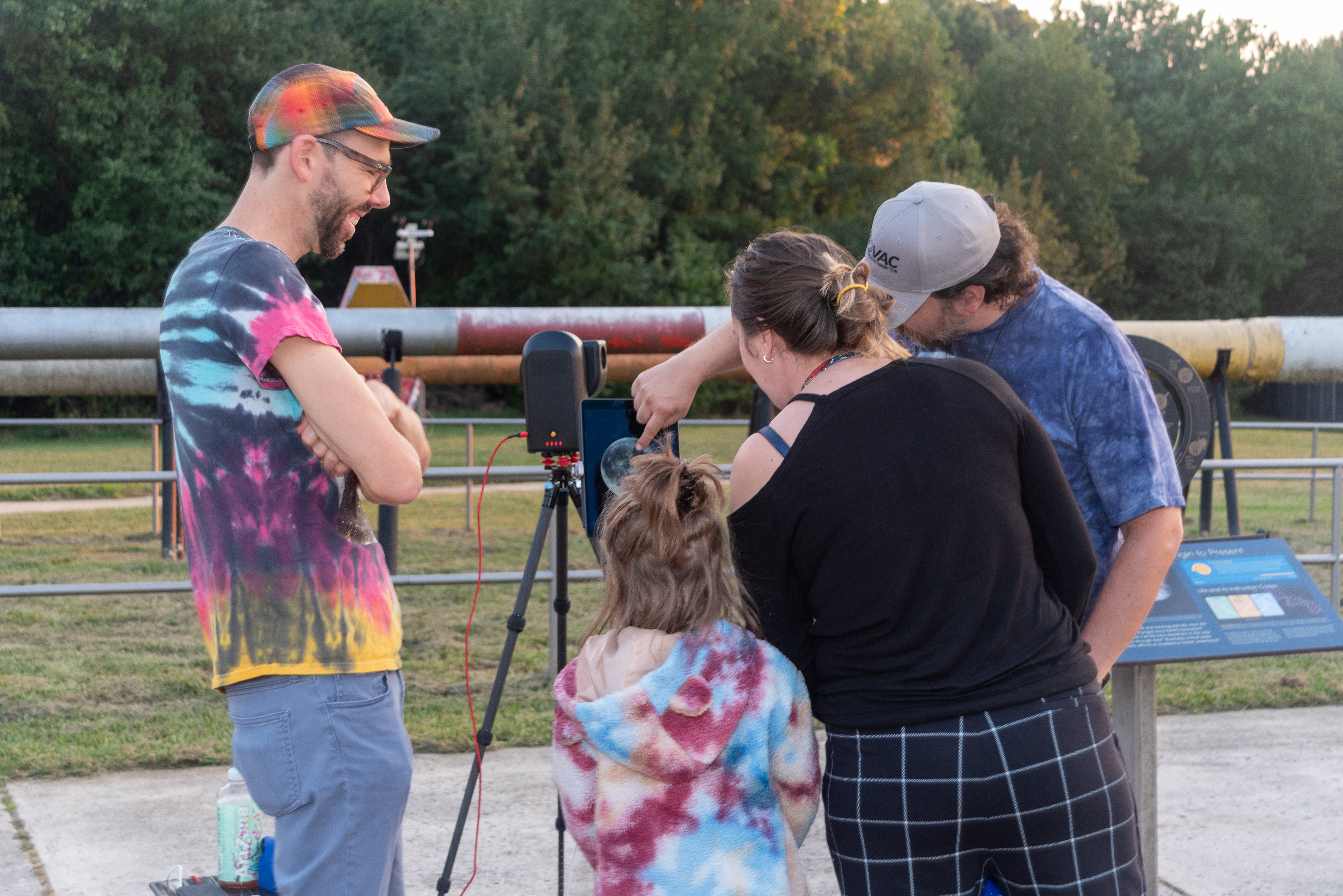
A child and two adults look at a tablet screen with a telescope’s display showing the full Moon. Another person stands to the left, smiling and looking on.
A family observes the Moon through a telescope at NASA’s Goddard Space Flight Center in Greenbelt, Md. during the International Observe the Moon Night celebration on Saturday, Sept. 14, 2024.
NASA/Britt Griswold

The event will also offer a chance to learn more about the groundbreaking research happening at NASA Goddard as scientists work to unlock the secrets of the Moon with missions like the Lunar Reconnaissance Orbiter (LRO) and explore our solar system and the universe beyond.
 
International Observe the Moon Night at Goddard is free and family friendly. Registration is not required, although registering in advance will help the Visitor Center team plan for the event. The event will take place rain or shine, and free parking is available at the Visitor Center.
 
Additional event details, including registration, accessibility and other logistics: https://www.nasa.gov/goddard/visitor-center/events-and-programs/.
 
For people who cannot travel to Greenbelt, there are opportunities to participate in International Observe the Moon Night from all around the planet. Join lunar observers around the world by observing the Moon with friends and family, attending a virtual event or finding an event in your area. Learn more and register your participation at go.nasa.gov/ObserveTheMoon.
 
International Observe the Moon Night is sponsored by NASA’s LRO mission and the Solar System Exploration Division of NASA’s Goddard Space Flight Center, with support from many partners. The celebration is a way for people to pause and look up at our future destination, as NASA prepares for deep space missions to the Moon and beyond.
 
To learn about NASA’s Artemis program, visit:
https://www.nasa.gov/artemis
 
To learn about LRO, visit:
https://www.nasa.gov/lro

Share

Details

Last Updated
Sep 15, 2026

NASA Completes Astronaut-Deployed Science Instrument for Lunar Surface

11 August 2026 at 20:41
Rectangular box-shaped device resting on a metal table. The front face is covered with a grid of many small black rectangular panels bordered in white. Metal components, brackets, and small box units are mounted along the top. The background shows a large windowed wall with a blurred American flag and an Artemis flag visible behind the device.
The fully-integrated LEMS (Lunar Environment Monitoring Station) ready for environmental testing. A small suitcase-size instrument suite built at NASA Goddard, LEMS is designed to carry out continuous, long-term monitoring of the seismic environment at the Moon, including surface motion caused by moonquakes and meteorite impacts in the lunar south polar region.
NASA Goddard/Mike Guinto

NASA has declared “wrenches down” on the first completed payload designed for Artemis astronauts to deploy on the Moon’s surface. Engineers working on NASA’s Lunar Environment Monitoring Station, or LEMS, have completed hardware development and testing and the payload is ready for its permanent home near the lunar South Pole. With the hardware complete, LEMS is ready to support one of the Artemis program’s core goals: enabling sustained lunar science and exploration.

The LEMS instrument package contains two highly sensitive seismometers that will monitor ground vibrations from moonquakes and meteorite impacts, providing scientists with insights into the Moon’s interior and the seismic hazards astronauts might encounter at the surface. Its modular design allows the system to be adapted or expanded to host new instruments in the future, creating a reusable platform that can evolve as scientific priorities grow.

The payload will remain in a clean room at NASA’s Goddard Space Flight Center in Greenbelt, Maryland, where it was built, until it is assigned to an Artemis mission for deployment to the lunar surface.

“The completion of the LEMS scientific instrument is a major step in a new era of lunar surface science. Innovative science experiments will uncover, measure, and reveal the Moon’s secrets while astronauts open new frontiers for discovery,” said Joel Kearns, deputy associate administrator for exploration, Science Mission Directorate, NASA Headquarters in Washington. “And, behind the scenes, countless teams across NASA and our partners are pushing the boundaries of what surface instruments can do, building the tools that will make future exploration possible and safer.”

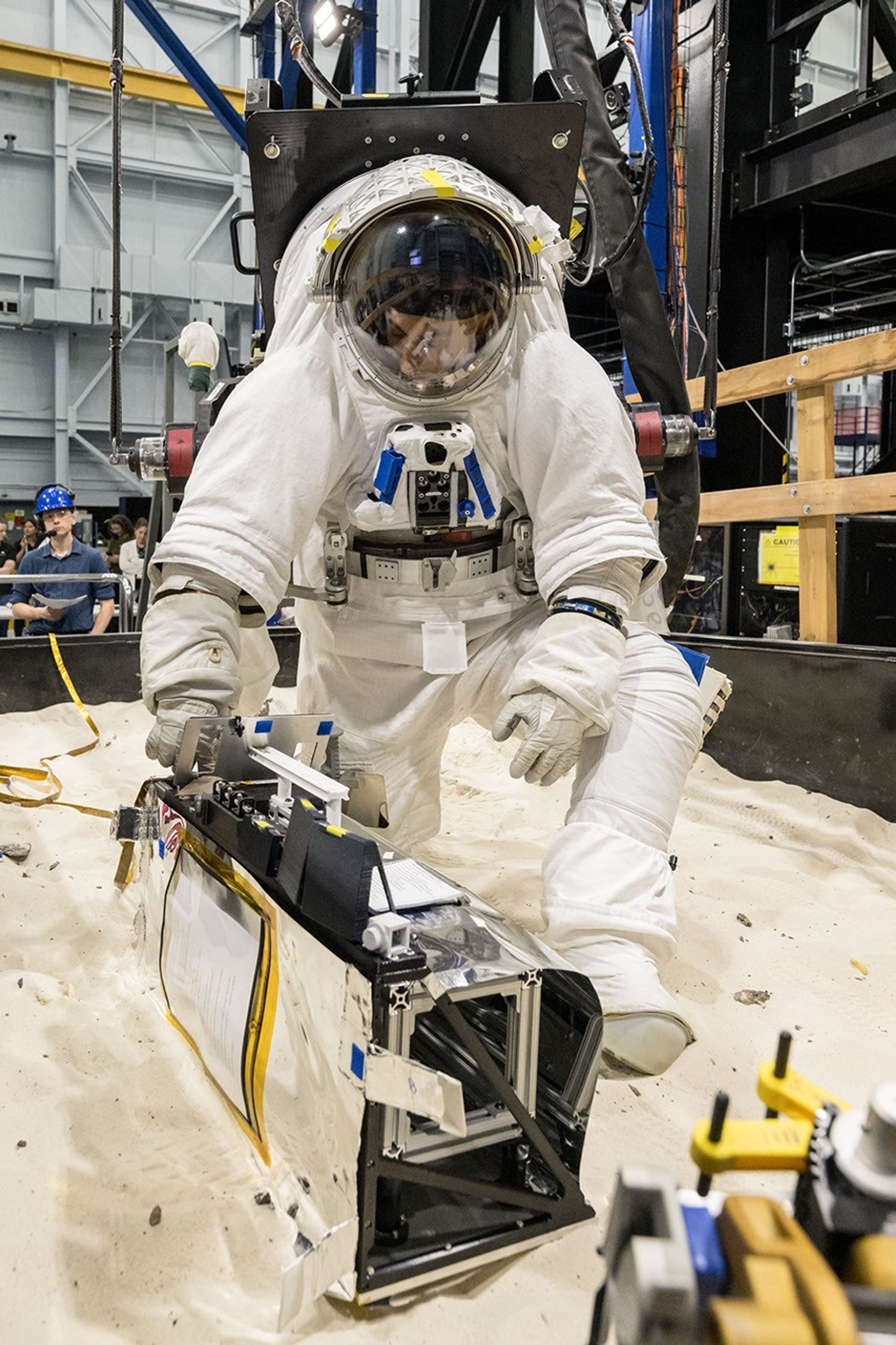
An astronaut in a white spacesuit kneels in simulated lunar soil while working with scientific equipment in a large testing facility. Staff members and support structures are visible in the background.
A scientist wearing NASA’s xEMU prototype space suit is testing the handling of a mockup version of NASA’s Lunar Environment Monitoring Station, or LEMS. The testing took place at the Active Response Gravity Offload System, a simulated reduced gravity environment at NASA’s Johnson Space Center in Houston.
NASA Johnson

The LEMS payload builds on a legacy of lunar seismic tracking. Apollo astronauts deployed a network of seismometers on the Moon’s nearside equatorial region between 1969 and 1972. Those instruments operated until 1977, recording about 13,000 moonquakes and other ground vibrations that helped scientists begin to understand the composition of the Moon’s interior. For decades, researchers have hoped to spread more seismometers, updated with new technologies, across the lunar surface.

Now, LEMS will carry the first seismometers to be deployed by future astronauts to listen for faint ground vibrations, collecting new clues to the Moon’s internal structure and ongoing seismic activity. The sensors will be the most compact, sensitive, and energy-efficient seismometers ever built for planetary exploration.

LEMS itself is about the size of a small suitcase, weighing 11 pounds in the Moon’s low-gravity environment. It will carry not just these seismic sensors, but everything it needs to function independently of humans after deployment. LEMS is built to manage its own power production via a lightweight, flexible solar array that conforms to the shape of the LEMS unit. It also will manage its operational activities to ensure continuous data collection based on a preset plan, and monthly data transmission to Earth. The payload will do all this while maintaining a stable internal temperature throughout the massive day-to-night temperature swings of the South Pole region.

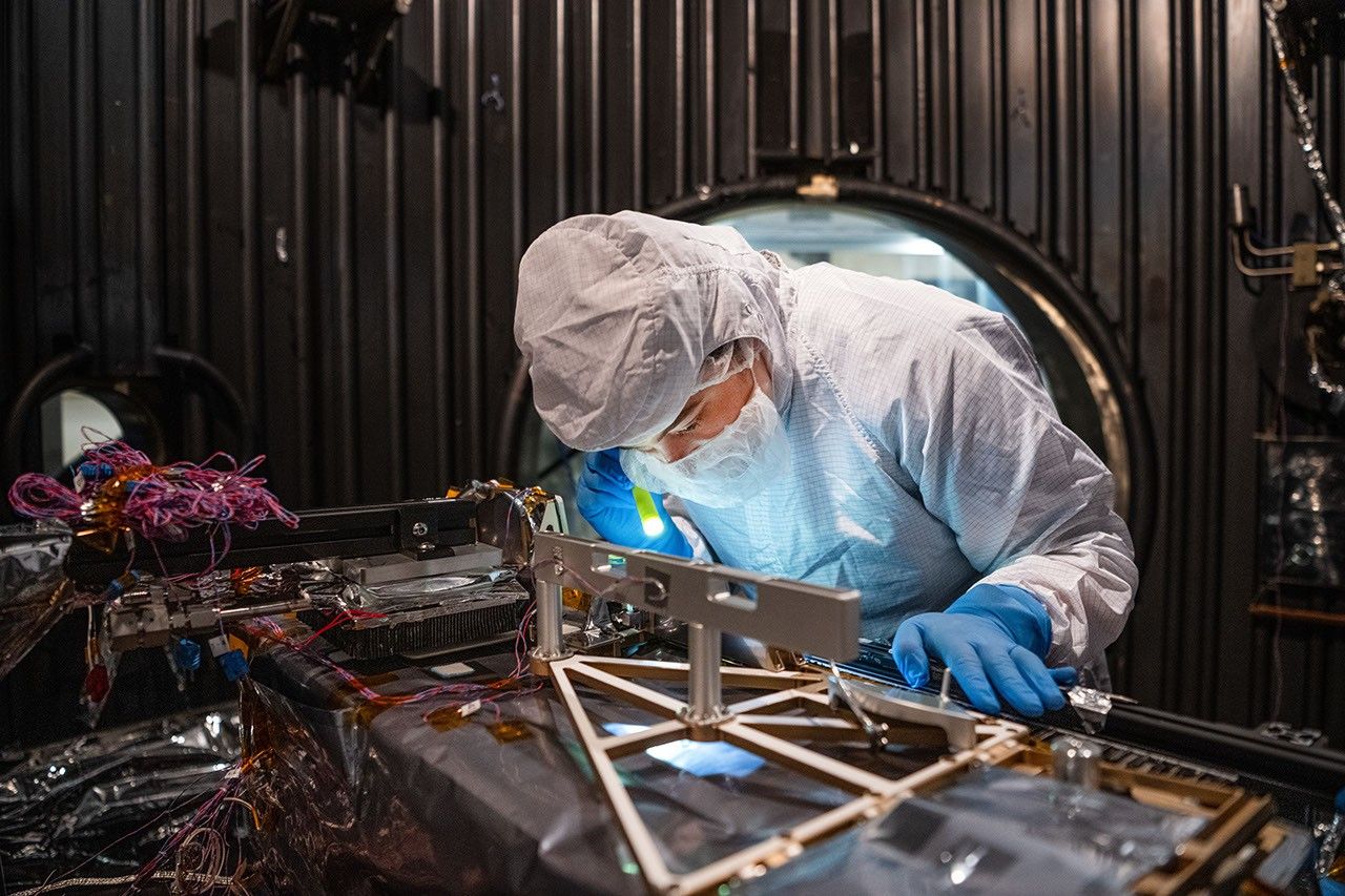
A technician in a white clean-room suit and blue gloves uses a small flashlight to inspect a spacecraft instrument inside a dark testing chamber. Colorful wires and metallic components surround the instrument.
Mechanical Engineer Brie Ludwig inspects the Lunar Environment Monitoring Station (LEMS) in preparation for testing in a thermal vacuum chamber at Goddard Space Flight Center in Greenbelt, Maryland, on March 31, 2026. LEMS is a compact, autonomous, and self-sustaining seismometer suite designed to carry out continuous, long-term monitoring of the lunar seismic environment at the South Polar region.
NASA/Denny Henry

“When we conceived of LEMS, we weren’t just thinking about the next mission, we were thinking about the next generation of lunar exploration,” said Mehdi Benna, a University of Maryland Baltimore County scientist who leads LEMS from NASA Goddard. “Our vision was to create a scientific buoy for the Moon. Like an ocean buoy on Earth, LEMS is designed to be easy to build, adaptable to different scientific objectives, and capable of operating independently for years.”

Before any surface science could happen, Benna and his team had to ensure that LEMS could survive the trip to the Moon and the harsh environment of its surface. Over the past five months, LEMS and its components have been subjected to a demanding series of environmental and operational tests. Engineers verified LEMS can endure the violent shaking of launch, the journey to the lunar surface, and the Moon’s temperature and radiation environment. The team also showed that the instrument package’s mechanical and electrical design is safe for astronaut handling.

The LEMS payload was built to operate through the lunar night, which lasts two Earth weeks, without external power assistance or a heat source. Past lunar surface instruments relied on radioisotope heaters for warmth and power. But LEMS instead will withstand temperatures that dip to minus 400 degrees Fahrenheit in some areas by using advanced insulation materials, low-thermal-conductivity cables that minimize heat loss, and a thermal regulator that conducts heat away during the day to prevent overheating and helps retain heat at night.

These innovations reduce mass and power needs, setting the stage for lighter, energy-efficient instruments that can operate continuously at future Artemis landing sites and the NASA-led Moon Base.

The LEMS payload is led by University of Maryland Baltimore County and University of Maryland College Park. Technical implementation is led by NASA Goddard. The University of Arizona, in partnership with Silicon Audio, Inc., supplied LEMS’ two state-of-the-art seismometers. Morehead State University in Kentucky provided LEMS’ telecommunication system and will operate the instrument on the surface. Washington University in St. Louis will manage the instrument’s data processing and dissemination to the larger scientific community.

EAGLE

31 July 2026 at 23:02

EAGLE

Explorer for Artemis Geology, Lunar, and Earth — a NASA satellite program to study surface biology and geology on Earth, with technologies that could support future missions to the Moon and Mars.

Future Mission

NASA’s EAGLE program — Explorer for Artemis Geology, Lunar, and Earth — will be a series of satellite missions studying surface properties using technologies for Earth observation that will also benefit future missions to the Moon and Mars, where they could identify critical resources and safe landing sites.

The satellites making up the first two EAGLE missions will study biology and geology on Earth’s surface to support agriculture, disaster response, and other needs. Each mission will carry a different instrument with capabilities that complement each other. The first mission (EAGLE-VSWIR) is scheduled to take flight in 2028.

Mission Type

Orbiter

Target

Earth, Moon, Mars

Launch

No earlier than 2028

Objective

Study surface composition and changes

  • EAGLE-VSWIR

    EAGLE-VSWIR (Visible to Shortwave Infrared) will observe the Earth’s surface every 16 days with a high-resolution imaging spectrometer, which measures light reflected from the planet’s surface, separating wavelengths across the visual and into the infrared spectrum. The patterns created by light being reflected or absorbed across this spectral range act like fingerprints, letting scientists identify the composition of the surface. 

    A similar instrument, NASA’s EMIT (Earth Surface Mineral Dust Source Investigation), has been monitoring Earth from the International Space Station since July 2022, characterizing the surface mineral composition of Earth’s arid lands, monitoring ecosystem status, and tracking health and safety hazards — such as methane leaks and acid mine drainage — among other applications.

    EAGLE-VSWIR will have 25 times more capability than EMIT has today. This technological leap will allow scientists to map surface deposits of critical and rare-earth minerals, strengthen food security, and aid wildfire prevention and recovery. It can also highlight environmental hazards such as oil spills or landslide risks, and monitor water quality and availability.

    Region of Nevada as observed by NASA's EMIT with spectrum on right edge
    The front of this image cube shows a region in Nevada observed by NASA’s EMIT imaging spectrometer; the cube’s sides show the spectral fingerprint for every point in the image and can be used to discover mineral resources. EAGLE-VSWIR will have 25 times greater performance beyond NASA’s current state-of-the-art EMIT.
    NASA/JPL-Caltech
  • EAGLE-TIR

    The EAGLE-TIR mission will provide Thermal InfraRed (TIR) imagery when it launches two to three years after EAGLE-VSWIR, measuring energy emitted from the surface and producing data that scientists can use to map temperature, composition, and critical mineral deposits. On Earth that would let researchers monitor wildfires and volcanic activity, track drought and water use by crops, study urban heat islands, observe the rates that snow or ice accumulates or melts, and better understand Earth’s resilient ecosystems.

    EAGLE-TIR follows on from ECOSTRESS (ECOsystem Spaceborne Thermal Radiometer Experiment on Space Station), which has been observing Earth from the International Space Station since 2018. ECOSTRESS was designed to study how different ecosystems respond to drought and water stress, and the data has provided a vital understanding of how plants’ water use changes throughout the day. Since ECOSTRESS also measures emitted energy in the thermal infrared, its surface-temperature products have also been used for urban planning and wildfire monitoring. 

    Further innovation and lessons learned from ECOSTRESS has led to EAGLE-TIR, which will carry a multi-band thermal radiometer. EAGLE-TIR’s great strength compared to existing missions is that it provides detailed imagery of the entire globe every two days, day and night, at multiple wavelengths not available from other instruments.

    Aerial view of Namib desert in Infrared captured by ECOSTRESS
    This image shows the minerals contained in Namibian dunes using ECOSTRESS data. EAGLE-TIR will have more spectral channels to enable even better mineral discrimination.
    NASA/JPL-Caltech
  • EAGLE Program

    By advancing vital techniques for measuring our planet’s surface composition, resources, and hazards, the EAGLE program addresses critical needs in Earth observation, with technologies that can also transfer to planetary exploration, where they’ll serve as pathfinders for future missions to the Moon and Mars.

    015B0489.NEF
    As the Artemis II crew came close to passing behind the Moon and experiencing a planned loss of signal, they captured this image of a crescent Earth setting on the Moon’s limb on April 6, 2026.
    NASA
Featured Video

EAGLE

NASA unveiled the EAGLE program as one part of its “Ignition” event on March 24, 2026, when it announced a wide-ranging series of transformative agencywide initiatives. With EAGLE (the Explorer for Artemis Geology, Lunar, and Earth missions), NASA will deploy breakthrough hyperspectral images across Earth with later missions anticipated for the Moon and Mars in rapid succession. On Earth they’ll identify critical minerals for national security, enable precision agriculture, and support disaster response. On Earth and at Mars they will locate critical minerals and resources such as ice for propellants, rare-earth elements for technology, and construction materials for habitats.

EMIT

EMIT (Earth Surface Mineral Dust Source Investigation) measures the mineral composition of Earth’s dust source regions, to help scientists understand how they heat or cool our planet.

Learn More About EMIT

ECOSTRESS

ECOSTRESS (ECOsystem Spaceborne Thermal Radiometer Experiment on Space Station) is accurately measuring the temperature of plants on Earth.

Learn More About ECOSTRESS

The post EAGLE appeared first on NASA Science.

💾

Join us for continuing coverage as our leaders discuss the agency's implementation of the National Space Policy and our plans to advance science and discover...

NASA’s ESCAPADE Snaps Family Portrait of Earth, Moon

24 July 2026 at 18:47

On July 3, one of NASA’s two Mars-destined ESCAPADE (Escape and Plasma Acceleration and Dynamics Explorers) spacecraft captured photos of Earth and the Moon in visible and thermal infrared light. At the time, the spacecraft was 363,250 miles (584,600 kilometers) from Earth and 115,600 miles (186,100 kilometers) from the Moon, making the Moon appear relatively large.

Taken with the Sun only partly illuminating Earth and the Moon, the visible light image shows the two bodies as crescents, with only around 8% of each face sunlit. Yet in the thermal infrared image, the shadowed hemisphere of Earth is illuminated by its own heat from both the atmosphere and surface, glowing at minus 10 to minus 44 degrees Fahrenheit (250 to 280 kelvins). Without the insulating blankets of oceans and atmospheres, the Moon’s far side remains at a much cooler minus 280 degrees Fahrenheit (100 kelvins).

visible light
thermal infrared light
A black background with a thin white crescent on the left representing the Earth, and a thin off-white crescent on the right represents the Moon.
Caption: In these images from NASA’s ESCAPADE mission, Earth (left) and Moon (right) can be seen. The image to the left of the slider shows visible light reflected by the Sun while the infrared image to the right shows the bodies’ emitted energy. White rings have been added in the thermal image to show the actual size of Earth and the Moon. Credit: NASA/UCB-SSL/NAU-Radiant/Lucint
NASA/UCB-SSL/NAU-Radiant/Lucint
On a pitch black background sits a bright circle on the left filled with yellow, orange, and red and surrounded by a faint halo of purple. On the right, is a circle outlined with a white line, filled with black and a thin purple crescent on the right side of the circle.
In these images from NASA’s ESCAPADE mission, Earth (left) and Moon (right) can be seen. The image to the left of the slider shows visible light reflected by the Sun while the infrared image to the right shows the bodies’ emitted energy. White rings have been added in the thermal image to show the actual size of Earth and the Moon.
NASA/UCB-SSL/NAU-Radiant/Lucint
visible light
thermal infrared light

ESCAPADE Photos of Earth and Moon

July 3, 2026

In these images from NASA’s ESCAPADE mission, Earth (left) and Moon (right) can be seen. The image to the left of the slider shows visible light reflected by the Sun while the infrared image to the right shows the bodies’ emitted energy. White rings have been added in the thermal image to show the actual size of Earth and the Moon. Credit: NASA/UCB-SSL/NAU-Radiant/Lucint

The ESCAPADE mission used its Visible and Infrared Observation System cameras, provided by Northern Arizona University in Flagstaff, to capture the images, which are more than just road trip photo album snaps.

“We are thrilled that ESCAPADE was able to accommodate these excellent space-qualified cameras which will search for visible Martian aurora and investigate thermal properties of the Martian surface and atmosphere,” said Rob Lillis, the mission’s principal investigator at the University of California, Berkeley. “Since Earth and the Moon are well-known targets, imaging them provides an important calibration check for ESCAPADE’s cameras.”

The ESCAPADE spacecraft, which were built by Rocket Lab, are currently in a “loiter” orbit around Lagrange point 2, a location in space about a million miles from Earth. In November 2026, the spacecraft will fly by Earth to use the planet’s gravity to slingshot their way to Mars. When the spacecraft arrive in September 2027, they will study how a million-mile-per-hour stream of material flowing from the Sun, known as solar wind, interacts with the Martian environment and how that drives atmospheric loss at the Red Planet.

The ESCAPADE mission is funded by NASA’s Heliophysics Division and is part of the NASA Small Innovative Missions for Planetary Exploration program. The UC Berkeley’s Space Sciences Laboratory leads the mission with key partners Rocket Lab; NASA’s Goddard Space Flight Center in Greenbelt, Maryland; Embry-Riddle Aeronautical University; Advanced Space; and Blue Origin.

By Mara Johnson-Groh
NASA’s Goddard Space Flight Center, Greenbelt, Md.

The post NASA’s ESCAPADE Snaps Family Portrait of Earth, Moon appeared first on NASA Science.

NASA’s ESCAPADE Snaps Family Portrait of Earth, Moon

24 July 2026 at 18:47

On July 3, one of NASA’s two Mars-destined ESCAPADE (Escape and Plasma Acceleration and Dynamics Explorers) spacecraft captured photos of Earth and the Moon in visible and thermal infrared light. At the time, the spacecraft was 363,250 miles (584,600 kilometers) from Earth and 115,600 miles (186,100 kilometers) from the Moon, making the Moon appear relatively large.

Taken with the Sun only partly illuminating Earth and the Moon, the visible light image shows the two bodies as crescents, with only around 8% of each face sunlit. Yet in the thermal infrared image, the shadowed hemisphere of Earth is illuminated by its own heat from both the atmosphere and surface, glowing at minus 10 to minus 44 degrees Fahrenheit (250 to 280 kelvins). Without the insulating blankets of oceans and atmospheres, the Moon’s far side remains at a much cooler minus 280 degrees Fahrenheit (100 kelvins).


visible light
thermal infrared light

A black background with a thin white crescent on the left representing the Earth, and a thin off-white crescent on the right represents the Moon.
Caption: In these images from NASA’s ESCAPADE mission, Earth (left) and Moon (right) can be seen. The image to the left of the slider shows visible light reflected by the Sun while the infrared image to the right shows the bodies’ emitted energy. White rings have been added in the thermal image to show the actual size of Earth and the Moon. Credit: NASA/UCB-SSL/NAU-Radiant/Lucint
NASA/UCB-SSL/NAU-Radiant/Lucint

On a pitch black background sits a bright circle on the left filled with yellow, orange, and red and surrounded by a faint halo of purple. On the right, is a circle outlined with a white line, filled with black and a thin purple crescent on the right side of the circle.
In these images from NASA’s ESCAPADE mission, Earth (left) and Moon (right) can be seen. The image to the left of the slider shows visible light reflected by the Sun while the infrared image to the right shows the bodies’ emitted energy. White rings have been added in the thermal image to show the actual size of Earth and the Moon.
NASA/UCB-SSL/NAU-Radiant/Lucint

A black background with a thin white crescent on the left representing the Earth, and a thin off-white crescent on the right represents the Moon.
Caption: In these images from NASA’s ESCAPADE mission, Earth (left) and Moon (right) can be seen. The image to the left of the slider shows visible light reflected by the Sun while the infrared image to the right shows the bodies’ emitted energy. White rings have been added in the thermal image to show the actual size of Earth and the Moon. Credit: NASA/UCB-SSL/NAU-Radiant/Lucint
NASA/UCB-SSL/NAU-Radiant/Lucint
On a pitch black background sits a bright circle on the left filled with yellow, orange, and red and surrounded by a faint halo of purple. On the right, is a circle outlined with a white line, filled with black and a thin purple crescent on the right side of the circle.
In these images from NASA’s ESCAPADE mission, Earth (left) and Moon (right) can be seen. The image to the left of the slider shows visible light reflected by the Sun while the infrared image to the right shows the bodies’ emitted energy. White rings have been added in the thermal image to show the actual size of Earth and the Moon.
NASA/UCB-SSL/NAU-Radiant/Lucint

visible light

thermal infrared light

ESCAPADE Photos of Earth and Moon

July 3, 2026


In these images from NASA’s ESCAPADE mission, Earth (left) and Moon (right) can be seen. The image to the left of the slider shows visible light reflected by the Sun while the infrared image to the right shows the bodies’ emitted energy. White rings have been added in the thermal image to show the actual size of Earth and the Moon. Credit: NASA/UCB-SSL/NAU-Radiant/Lucint

The ESCAPADE mission used its Visible and Infrared Observation System cameras, provided by Northern Arizona University in Flagstaff, to capture the images, which are more than just road trip photo album snaps.

“We are thrilled that ESCAPADE was able to accommodate these excellent space-qualified cameras which will search for visible Martian aurora and investigate thermal properties of the Martian surface and atmosphere,” said Rob Lillis, the mission’s principal investigator at the University of California, Berkeley. “Since Earth and the Moon are well-known targets, imaging them provides an important calibration check for ESCAPADE’s cameras.”

The ESCAPADE spacecraft, which were built by Rocket Lab, are currently in a “loiter” orbit around Lagrange point 2, a location in space about a million miles from Earth. In November 2026, the spacecraft will fly by Earth to use the planet’s gravity to slingshot their way to Mars. When the spacecraft arrive in September 2027, they will study how a million-mile-per-hour stream of material flowing from the Sun, known as solar wind, interacts with the Martian environment and how that drives atmospheric loss at the Red Planet.

The ESCAPADE mission is funded by NASA’s Heliophysics Division and is part of the NASA Small Innovative Missions for Planetary Exploration program. The UC Berkeley’s Space Sciences Laboratory leads the mission with key partners Rocket Lab; NASA’s Goddard Space Flight Center in Greenbelt, Maryland; Embry-Riddle Aeronautical University; Advanced Space; and Blue Origin.

By Mara Johnson-Groh
NASA’s Goddard Space Flight Center, Greenbelt, Md.

Hanging in the Balance

23 June 2026 at 16:43
The Moon's rugged surface is on display in this image. Most of the Moon is visible, with the bottom of the sphere disappearing into the darkness. This line between light and dark is called the terminator. The terminator is lined with many craters.
The Moon’s rocky, uneven, and otherworldly surface features are highlighted by the terminator – the difference between light and darkness.
NASA

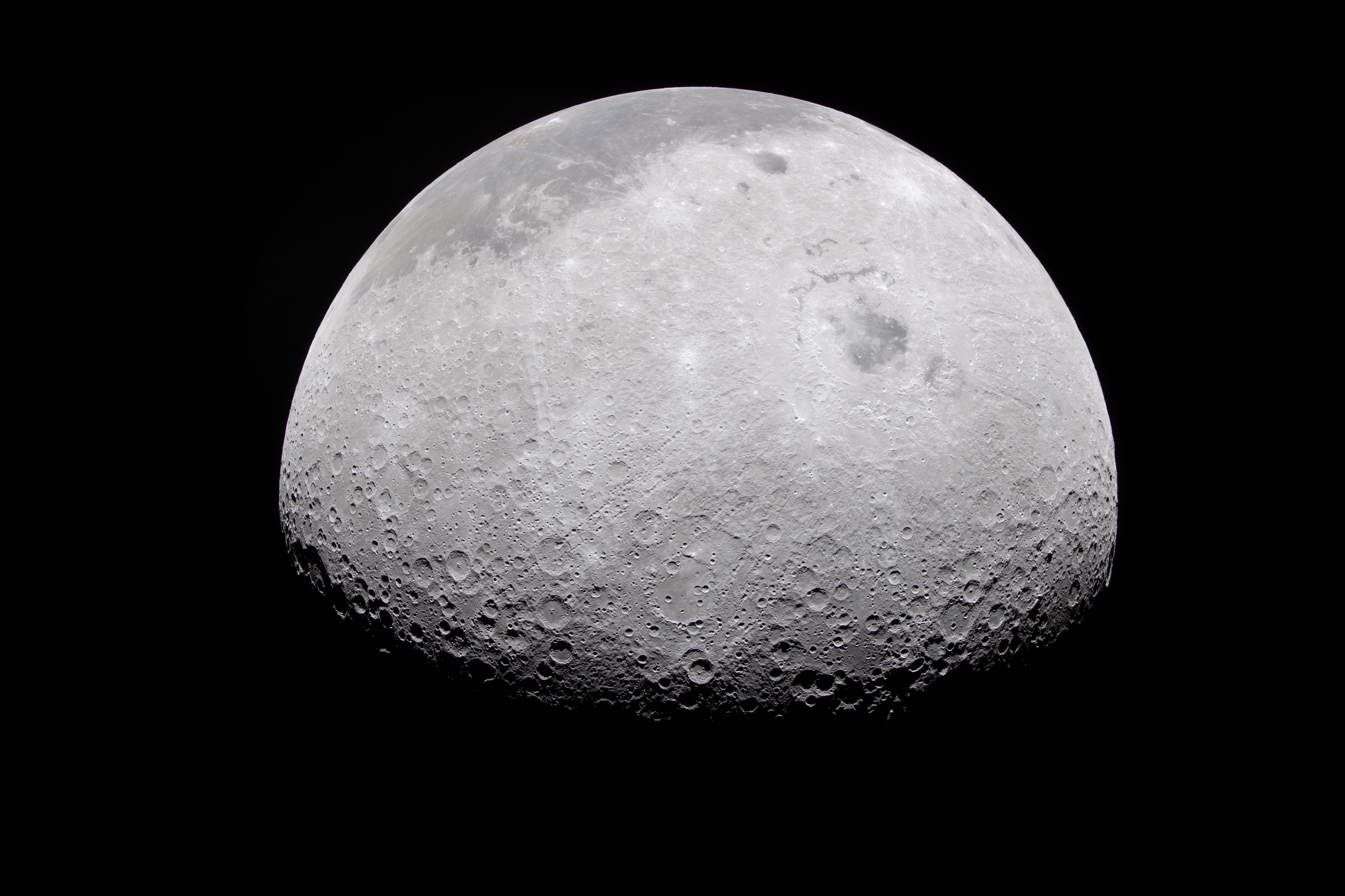
The Moon appears half-illuminated in this photo captured by the Artemis II crew on flight day 6. The terminator – the difference between light and darkness – provides a stark contrast and even greater perspective of the Moon’s rocky, uneven, and otherworldly surface features. The near side, which is what we can see from Earth, appears in the dark gray regions at the top of this image.

Revisit imagery from the Artemis II mission.

Image credit: NASA

NASA Testing Advanced Capabilities for Moon, Mars Rovers

18 June 2026 at 19:19
A white four-wheeled rover with a rectangular head on its mast projects a red glow onto a dark desert landscape. Pink and yellow hues indicate the sun has set behind a distant mountain range, while the top of the frame remains blue.
Developed at NASA’s Jet Propulsion Laboratory, ERNEST (Exploration Rover for Navigating Extreme Sloped Terrain) is used in a desert field test to help refine mobility hardware and autonomy software that could be used for a potential future long-range lunar rover mission.
A white four-wheeled rover on the left side of the frame casts a long shadow across barren, brown ground toward the lower right. A few low, scrubby plants dot the desert landscape and mountains rise in the far distance under a pale blue sky.
During the field test, which took place in March 2026 in the Colorado Desert of Southern California, the JPL team deployed ERNEST at all times of the day — including dusk, dawn, and nighttime, when lighting conditions create long shadows like those seen on the Moon’s polar regions.

On a bleak stretch of the Colorado Desert in Southern California, a compact four-wheeled rover recently trundled about 16 miles (26 kilometers) with minimal intervention from the team of engineers trailing it. Called ERNEST (Exploration Rover for Navigating Extreme Sloped Terrain), this prototype is being used by NASA to advance both robotic autonomy and the ability to traverse challenging landscapes.

Developed at NASA’s Jet Propulsion Laboratory in Southern California, ERNEST is 4 feet (1.2 meters) long. Not only can it lift each of its mesh wheels to get past obstacles that would stymie Curiosity and Perseverance, NASA’s six-wheeled Mars rovers, but the prototype also has enhanced independent decision-making capabilities. These mobility and autonomy advances could be infused into future missions that will venture to previously inaccessible areas of the Red Planet or the Moon.

ERNEST serves as a testbed for a potential future lunar rover mission requiring high speeds and extreme distances. In a recent field test, the prototype traveled 16 miles over the course of 37 hours, going an order of magnitude above the top speed at which NASA’s current Mars rovers can navigate. Credit: NASA/JPL-Caltech

In the field, ERNEST served as a testbed for a potential future lunar mission requiring higher speeds and much greater mileage than can be accomplished by current rovers. This technology could be used to inform future designs for exploration efforts on the Moon and beyond.

“This testing is helping us refine the mobility hardware and autonomy software to navigate extreme distances across a wide range of terrain and lighting conditions anticipated on the Moon,” said Issa Nesnas, a principal technologist at JPL who led the recent testing as head of autonomy for a NASA mission concept for a potential future long-range lunar rover.

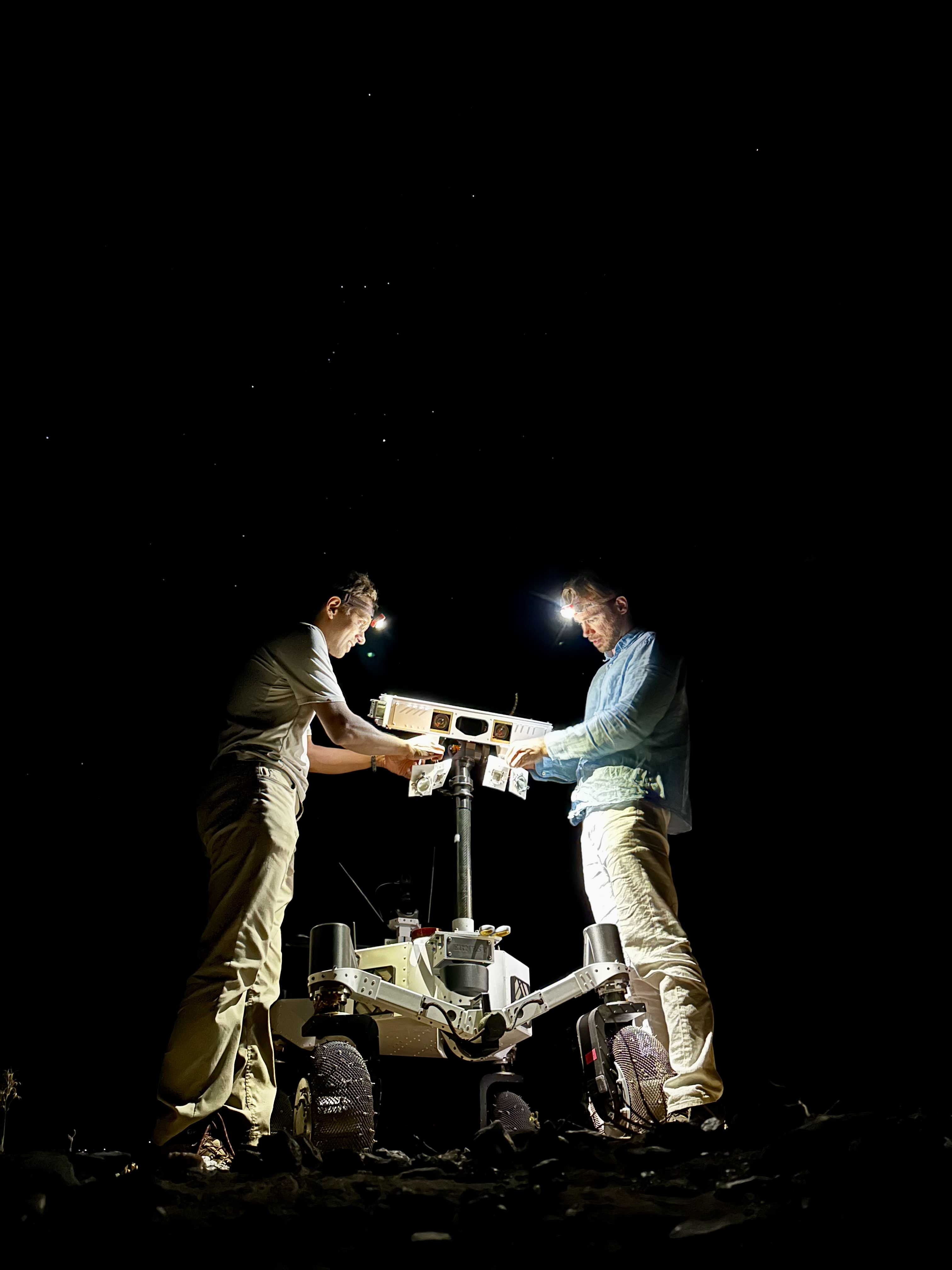
Against a pitch-black background sky in which a handful of white stars are visible, two men stand on either side of a 4.5-foot-tall white rover, which is lit up by the glow from their headlamps as they set up the illuminators on the robot’s mast.
Engineers from JPL set up illuminators after transporting ERNEST for a pre-sunrise test during a seven-day desert field campaign.
NASA/JPL-Caltech

Nesnas’ team is using ERNEST to demonstrate it is possible to build a rover that’s twice as big as the prototype and capable of a long-distance Moon mission. During the recent campaign, ERNEST traveled at speeds up to 0.6 mph (1 kph) over 37 hours of driving, across seven days of intermittent testing. That’s an order of magnitude above the top speed Perseverance and Curiosity can navigate.

“You could do a science road trip across the Moon — or Mars — with this vehicle,” said James Keane, a JPL planetary scientist working on lunar missions.

The initial goal of the team that developed ERNEST was mechanical: to design a relatively simple, low-cost rover that advances the trusted rocker-bogie suspension system featured on every Mars rover since NASA’s Sojourner. This passive system keeps relatively constant weight on all six wheels, thanks to pivot points and struts that enable each one to adapt to the changing surface.

The mobility and autonomy advances developed at JPL for the ERNEST prototype rover could be infused into future NASA missions to previously inaccessible areas of the Red Planet or the Moon. Credit: NASA/JPL-Caltech

On ERNEST, the active suspension lets the rover manage weight distribution among its wheels. Two powered joints in front articulate a gimbal that allows the rover to drive using different gaits like squirming, wheel-walking, and obstacle-climbing. With a clutch mechanism, it can switch between active and passive suspension, which is less terrain capable but more energy efficient. With four steerable wheels, it can drive in any direction, including sideways.

“We started by postulating that we could do better in designing a planetary surface robotic mobility system,” said Hari Nayar, a JPL principal technologist leading the ERNEST team. “While the rocker-bogie system has been very successful over the past 30 years, there’s been a lot of research in that time on mobility and understanding terrain interaction.”

Before arriving at today’s version of ERNEST, the team built two earlier prototypes, each about 2 feet (0.6 meters) long, to test 11 active suspension configurations. In a trailer filled with lunar regolith simulant, they ran experiments at different slope angles over several months before landing on a final design.

Then the team scaled up, including adding a rectangular head mounted on a 4.5-foot-tall (1.4-meter-tall) mast. The hardware was completed in September 2024, but the rover still needed a human operator to joystick it, sending commands to instruct the rover on how to move over obstacles.

In order to train the rover to think on its own, the ERNEST team turned to reinforcement learning, a type of artificial intelligence where the robot learns by interacting with its environment. The Dynamics and Real-Time Simulation Laboratory at JPL developed a high-fidelity virtual testing environment that replicates the rover’s behavior. The team fed the simulator data collected by engineers who documented the response of the actual rover hardware to a variety of terrain types. On a high-performance computing cluster, the team ran many simulations at once, sometimes completing thousands of hours of tests over a single weekend.

After months of virtual training, the ERNEST team was ready to see if the rover could use its new autonomous algorithms to figure out how to drive over terrain features that would halt a passive-suspension rover. They set up an obstacle course with sand ripples, rubble piles, steps, and steep slopes in JPL’s Mars Yard, an outdoor terrain proving ground. Then they watched as the rover maneuvered the terrain on its own. Since then, ERNEST has completed many such courses.

Nayar’s team is starting a new autonomy project which involves integrating the rover’s ability to determine when and how to use its active suspension with longer-range intelligent navigation. The goal is to enable ERNEST to plan an efficient path so that it can tackle surmountable obstacles and circumnavigate hazardous ones. These capabilities could contribute to potential future rover missions encountering formidable landscapes on Mars or more rugged areas of the Moon.

Work on ERNEST began in 2022 was initially supported by JPL internal research and development funds. It is currently funded by NASA’s Mars Exploration Program and the agency’s Exploration Science Strategy and Integration Office in its Science Mission Directorate at NASA Headquarters in Washington. Caltech in Pasadena, California, manages JPL for NASA.

Media Contacts

Karen Fox / Molly Wasser
NASA Headquarters, Washington
240-285-5155 / 240-419-1732
karen.c.fox@nasa.gov / molly.l.wasser@nasa.gov   

Melissa Pamer
Jet Propulsion Laboratory, Pasadena, Calif.
626-314-4928
melissa.pamer@jpl.nasa.gov

2026-040

The post NASA Testing Advanced Capabilities for Moon, Mars Rovers appeared first on NASA Science.

NASA Testing Advanced Capabilities for Moon, Mars Rovers

18 June 2026 at 19:19
A white four-wheeled rover with a rectangular head on its mast projects a red glow onto a dark desert landscape. Pink and yellow hues indicate the sun has set behind a distant mountain range, while the top of the frame remains blue.
Developed at NASA’s Jet Propulsion Laboratory, ERNEST (Exploration Rover for Navigating Extreme Sloped Terrain) is used in a desert field test to help refine mobility hardware and autonomy software that could be used for a potential future long-range lunar rover mission.
A white four-wheeled rover on the left side of the frame casts a long shadow across barren, brown ground toward the lower right. A few low, scrubby plants dot the desert landscape and mountains rise in the far distance under a pale blue sky.
During the field test, which took place in March 2026 in the Colorado Desert of Southern California, the JPL team deployed ERNEST at all times of the day — including dusk, dawn, and nighttime, when lighting conditions create long shadows like those seen on the Moon’s polar regions.

On a bleak stretch of the Colorado Desert in Southern California, a compact four-wheeled rover recently trundled about 16 miles (26 kilometers) with minimal intervention from the team of engineers trailing it. Called ERNEST (Exploration Rover for Navigating Extreme Sloped Terrain), this prototype is being used by NASA to advance both robotic autonomy and the ability to traverse challenging landscapes.

Developed at NASA’s Jet Propulsion Laboratory in Southern California, ERNEST is 4 feet (1.2 meters) long. Not only can it lift each of its mesh wheels to get past obstacles that would stymie Curiosity and Perseverance, NASA’s six-wheeled Mars rovers, but the prototype also has enhanced independent decision-making capabilities. These mobility and autonomy advances could be infused into future missions that will venture to previously inaccessible areas of the Red Planet or the Moon.

ERNEST serves as a testbed for a potential future lunar rover mission requiring high speeds and extreme distances. In a recent field test, the prototype traveled 16 miles over the course of 37 hours, going an order of magnitude above the top speed at which NASA’s current Mars rovers can navigate. Credit: NASA/JPL-Caltech

In the field, ERNEST served as a testbed for a potential future lunar mission requiring higher speeds and much greater mileage than can be accomplished by current rovers. This technology could be used to inform future designs for exploration efforts on the Moon and beyond.

“This testing is helping us refine the mobility hardware and autonomy software to navigate extreme distances across a wide range of terrain and lighting conditions anticipated on the Moon,” said Issa Nesnas, a principal technologist at JPL who led the recent testing as head of autonomy for a NASA mission concept for a potential future long-range lunar rover.

Against a pitch-black background sky in which a handful of white stars are visible, two men stand on either side of a 4.5-foot-tall white rover, which is lit up by the glow from their headlamps as they set up the illuminators on the robot’s mast.
Engineers from JPL set up illuminators after transporting ERNEST for a pre-sunrise test during a seven-day desert field campaign.
NASA/JPL-Caltech

Nesnas’ team is using ERNEST to demonstrate it is possible to build a rover that’s twice as big as the prototype and capable of a long-distance Moon mission. During the recent campaign, ERNEST traveled at speeds up to 0.6 mph (1 kph) over 37 hours of driving, across seven days of intermittent testing. That’s an order of magnitude above the top speed Perseverance and Curiosity can navigate.

“You could do a science road trip across the Moon — or Mars — with this vehicle,” said James Keane, a JPL planetary scientist working on lunar missions.

The initial goal of the team that developed ERNEST was mechanical: to design a relatively simple, low-cost rover that advances the trusted rocker-bogie suspension system featured on every Mars rover since NASA’s Sojourner. This passive system keeps relatively constant weight on all six wheels, thanks to pivot points and struts that enable each one to adapt to the changing surface.

The mobility and autonomy advances developed at JPL for the ERNEST prototype rover could be infused into future NASA missions to previously inaccessible areas of the Red Planet or the Moon. Credit: NASA/JPL-Caltech

On ERNEST, the active suspension lets the rover manage weight distribution among its wheels. Two powered joints in front articulate a gimbal that allows the rover to drive using different gaits like squirming, wheel-walking, and obstacle-climbing. With a clutch mechanism, it can switch between active and passive suspension, which is less terrain capable but more energy efficient. With four steerable wheels, it can drive in any direction, including sideways.

“We started by postulating that we could do better in designing a planetary surface robotic mobility system,” said Hari Nayar, a JPL principal technologist leading the ERNEST team. “While the rocker-bogie system has been very successful over the past 30 years, there’s been a lot of research in that time on mobility and understanding terrain interaction.”

Before arriving at today’s version of ERNEST, the team built two earlier prototypes, each about 2 feet (0.6 meters) long, to test 11 active suspension configurations. In a trailer filled with lunar regolith simulant, they ran experiments at different slope angles over several months before landing on a final design.

Then the team scaled up, including adding a rectangular head mounted on a 4.5-foot-tall (1.4-meter-tall) mast. The hardware was completed in September 2024, but the rover still needed a human operator to joystick it, sending commands to instruct the rover on how to move over obstacles.

In order to train the rover to think on its own, the ERNEST team turned to reinforcement learning, a type of artificial intelligence where the robot learns by interacting with its environment. The Dynamics and Real-Time Simulation Laboratory at JPL developed a high-fidelity virtual testing environment that replicates the rover’s behavior. The team fed the simulator data collected by engineers who documented the response of the actual rover hardware to a variety of terrain types. On a high-performance computing cluster, the team ran many simulations at once, sometimes completing thousands of hours of tests over a single weekend.

After months of virtual training, the ERNEST team was ready to see if the rover could use its new autonomous algorithms to figure out how to drive over terrain features that would halt a passive-suspension rover. They set up an obstacle course with sand ripples, rubble piles, steps, and steep slopes in JPL’s Mars Yard, an outdoor terrain proving ground. Then they watched as the rover maneuvered the terrain on its own. Since then, ERNEST has completed many such courses.

Nayar’s team is starting a new autonomy project which involves integrating the rover’s ability to determine when and how to use its active suspension with longer-range intelligent navigation. The goal is to enable ERNEST to plan an efficient path so that it can tackle surmountable obstacles and circumnavigate hazardous ones. These capabilities could contribute to potential future rover missions encountering formidable landscapes on Mars or more rugged areas of the Moon.

Work on ERNEST began in 2022 was initially supported by JPL internal research and development funds. It is currently funded by NASA’s Mars Exploration Program and the agency’s Exploration Science Strategy and Integration Office in its Science Mission Directorate at NASA Headquarters in Washington. Caltech in Pasadena, California, manages JPL for NASA.

Media Contacts

Karen Fox / Molly Wasser
NASA Headquarters, Washington
240-285-5155 / 240-419-1732
karen.c.fox@nasa.gov / molly.l.wasser@nasa.gov   

Melissa Pamer
Jet Propulsion Laboratory, Pasadena, Calif.
626-314-4928
melissa.pamer@jpl.nasa.gov

2026-040

💾

Engineers from NASA’s Jet Propulsion Laboratory are field-testing advanced capabilities for potential future Moon and Mars rovers. In the Colorado Desert nea...

Register

17 June 2026 at 19:42

Register to Observe the Moon with NASA

Image credit: Zach Tejral | Location: Antarctica

How to Register for International Observe the Moon Night

Choose the type of registration that best matches your Moon observing plans:

Colorized photo of kid pointing to a screen with the Moon, with text overlay: Individual / Household Registration.

Individual/Household Registration

If you are observing the Moon on your own or with people in your household, register here.

Colorized photo a group of people gathered at night to look through a telescope. In the foreground, a screen displays "International Observe the Moon Night"; text overlay: Host a Public Event

Host a Public Event

If you are organizing and hosting a Moon observing event that is free and open to everyone, register here.

Colorized photo of school children holding up certificates, with text overlay: Host a Private Event

Host a Private Event

If you are organizing and hosting a Moon observing event for a private group, register here.

Planning Resources

A man adjusting a telescope outdoors.

Event Planning Guide

How to host an International Observe the Moon Night event, in 8 easy steps.

A hand holding a passport next to a telescope outdoors

Sample Event Outline

Looking for ideas about how to structure your event? This outline can help.

A white Moon is painted on a bluish gray background, with rings of color surrounding the Moon. The thin branches of a tree stretch upwards towards the Moon. Black flowers speckle the lower right portion of the painting.

10 Ways to Observe the Moon from Home

Observing the Moon is something you can do no matter the weather, time of day, or location! Here are some of our favorite ways to observe.

Librarian reads a story next to a gigantic Moon model, outdoors, with a crowd of families seated on chairs and on the grass and standing on the sidewalk nearby.

Find a Local Event to Join

Check the Find-An-Event Database for International Observe the Moon Night events near you, or to find a virtual event.

The post Register appeared first on NASA Science.
❌