Archaeologists have discovered an iron cannonball fired by Texans at the Battle of the Alamo in 1836. This is the second intact cannonball they have discovered from the famous conflict. The first one, a bronze cannonball, was found earlier this year and was likely fired by the Mexican army.
"It's a huge deal," Tiffany Lindley, director of archaeology at the Alamo, said in a video statement from Alamo Trust. "We all thought, 'There's no way we can top it,'" she said, referring to the bronze cannonball discovered March 5, just a day before the 190th anniversary of the conflict that killed Davy Crockett, "and then we found another one."
Both cannonballs were recovered from the northeast corner of the church at the Alamo, which was originally built in 1718 as a Spanish mission and fortress in what is now San Antonio. But the Alamo is better known as the location of an 1836 battle during the Texas Revolution, in which Anglo-American settlers and Hispanic Texans known as Tejanos seceded from the Republic of Mexico.
In a 13-day siege culminating in a deadly assault on March 6, 1836, Mexican troops, commanded by Gen. Antonio López de Santa Anna, surrounded the Alamo and killed the 180 Texan rebels defending the structure, including Davy Crockett. The cry "Remember the Alamo!" was used in later skirmishes in the Texas Revolution as soldiers fought Mexican troops for independence.
The newly excavated iron cannonball was found June 2, according to a statement from Alamo Trust.
Of the two cannonballs, "the newest one is slightly larger" and was likely fired from a cannon that shot 6-pound [2.7 kilogram] cannonballs, Kolby Lanham, a senior researcher and historian at the Alamo, said in the statement. "The likelihood is that the bronze one belonged to the Mexican Army and the iron one belonged to the Texans."
Over the years, archaeologists have found numerous pieces of ammunition and shrapnel at the Alamo, Lindley said, but these cannonballs are the first examples of solid shots — spherical projectiles fired from a gun or cannon — they have ever found.
"It's just a huge kind of once-in-a-lifetime deal," Lanham said. "But obviously, it's happened twice."
The size and weight of the cannonball suggests it was fired by a cannon that shot 6-pound cannonballs. (Image credit: Alamo Trust)
The Mexican and Texan cannonballs were found near each other, so they are likely the historic remains of the two sides shooting at each other in the fateful siege nearly two centuries ago.
"Whenever they were dropped the very first time — possibly in 1836, probably — they haven't been touched since, and that's what makes them extra special," Lindley said. "I don't think you can undersell it."
The Alamo remains an active archaeological site, where experts have discovered artifacts that span its centuries of history, from Indigenous stone tools that predate the Spanish mission through the late 19th century, when the structure was converted into a general store and warehouse.
Physicists recently wondered what would happen if you tried to split a photon — and they found some unexpected behavior that may transform the way we think about particles.
The experiment, in which researchers simulated a photon being sliced by a shutter under various conditions, showed that a severed photon can lead to a complex mixture of zero to infinitely-many photons — raising some big questions about the nature of particle interactions.
Photons are elementary packets of light, which means they are not made up of anything else. So what does it even mean to try splitting a photon? It may be possible thanks to wave-particle duality — a core principle of quantum mechanics, the bizarre physics of the very small.
According to wave-particle duality, a photon is not only a particle but also a wave. Using theoretical calculations, the researchers investigated what would happen if you sent this photon through a shutter and closed it while the photon was passing through, effectively cutting off the tail end of the photon wave.
"I think that most physicists would expect there to be a certain probability that you have zero photons and a certain probability that you have a single photon left after you have done this," Johannes Skaar, co-author of the new study and a professor of theoretical physics at the University of Oslo, told Live Science. "And that is approximately true, but it is not exactly true."
What are the chances?
This brings up another strange aspect of quantum mechanics: its probabilistic nature. Particles exist as a cloud of probabilities stretching to infinity. Until a particle is observed, its properties, such as its position or energy, are in a superposition of possible values; all we can know are the chances of finding it in a certain state.
Through their calculations, Skaar and his colleagues determined how cutting a photon affects these probabilities. In their study, recently accepted in the journal Physical Review Letters, they found that it would create a complex mixture of photon states, including one with an infinite number of photons.
Each of these states has a probability that depends on how quickly the shutter cuts the photon. The expected number of photons becomes infinite only if the shutter is closed infinitely quickly. For realistic shutter speeds, even a thousand photons would be extremely unlikely.
This may sound very strange, but the quantum physicists were unfazed. In fact, what surprised Skaar and his colleagues was what happens if you make measurements of the cut photon from different perspectives.
A photo of an optical table with laser and beam-splitting cube, often used in photonics research. (Image credit: EschCollection via Getty Images)
"When you measure from one side of the shutter, then it will look like a single photon state," Skaar said. "Then, on the other side, it will look like a vacuum state — that means no photons. And that is very strange because the actual state globally is this mixture from zero to infinity."
Changing how we think about particles
The fact that these complex mixtures can be treated locally as very simple states raises fundamental questions about the nature of particles. Skaar said they are still reckoning with the full extent of these implications and they are now considering how this process could play out for other quantum particles, such as electrons.
They hope that by following this theoretical thread through, they may be able to develop a neater way of describing particle interactions. Currently, particles' infinite stretching means they have been interacting for an infinite amount of time. This then poses a problem for causality — the order of cause and effect — in particle interactions, the team said.
These new theoretical photons with a cutoff tail would not have this problem, meaning the causal link in an interaction would be clear, Skaar said. He admitted that there is much more work to be done to develop the theoretical description of this interaction. However, the new result is an important step toward describing particle interactions with a clear causal relationship, which Skaar described as the team's "ultimate goal."
Hunter-gatherers in Siberia fell victim to lethal plague outbreaks around 5,500 years ago, marking the oldest known evidence of plague to date, a new study finds.
A research team investigating the Stone Age remains identified ancient DNA ion over a dozen individuals that came from previously unknown strains of Yersinia pestis, a bacterium that causes pneumonic, bubonic and septicemic plague.
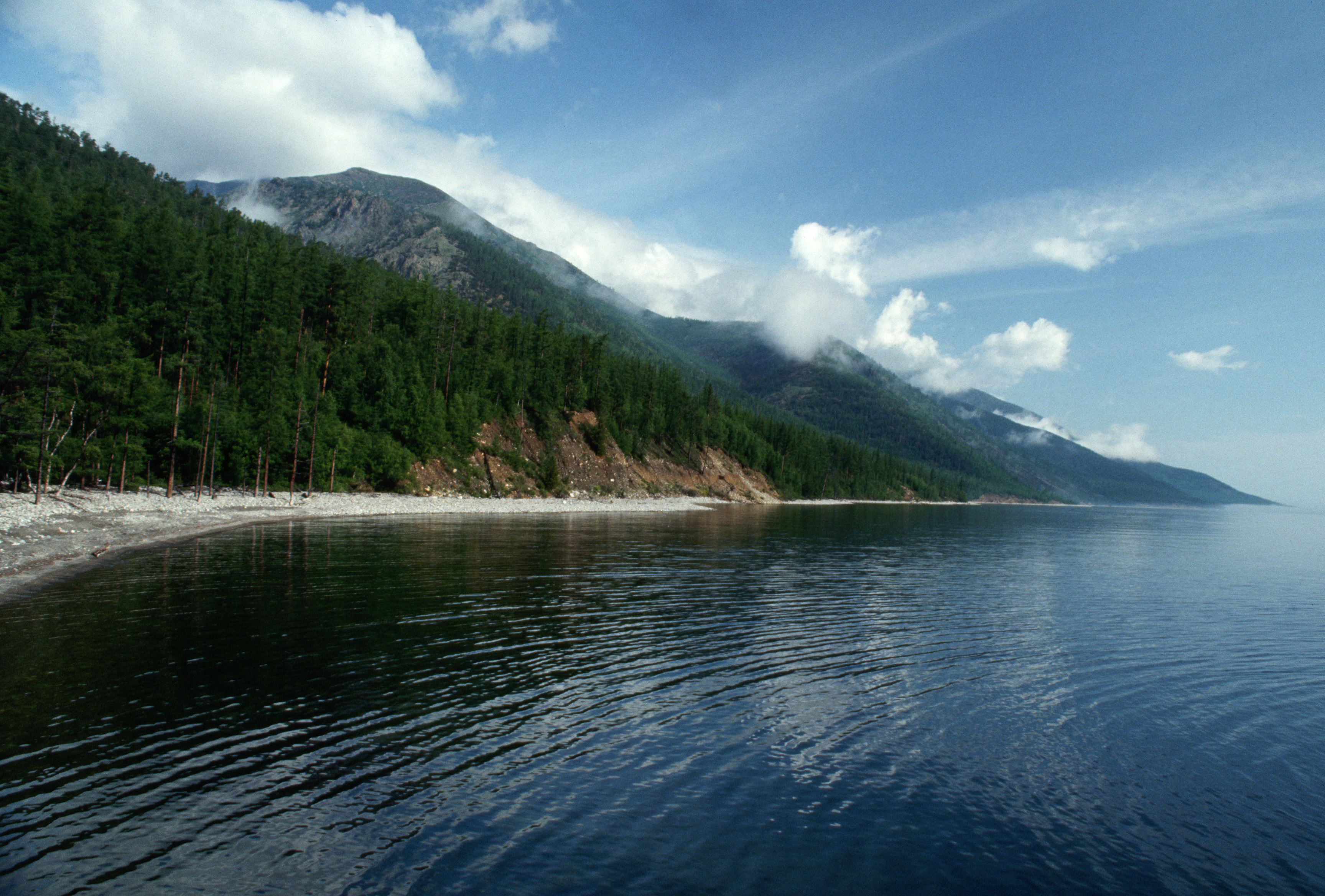
The disease that infected these hunter-gatherers, most likely pneumonic plague, probably spilled over from wild marmots, and ravaged through family groups living around Lake Baikal, according to the study, published Wednesday (June 17) in the journal Nature.
Ancient DNA from the two newfound plague strains revealed a unique gene that codes for proteins that trigger massive immune responses, perhaps explaining why children were the most likely to die from the disease, the authors wrote in the study.
The discovery of two deadly plague outbreaks in prehistoric hunter-gatherers challenges the long-standing assumption that epidemics first occurred after the rise of agriculture, study first author Ruairidh Macleod, a researcher of ancient genomics at the University of Oxford, told Live Science.
"We got the really striking result that we found lots and lots of plague here far earlier than we expected," Macleod said. This is "the closest we'll probably ever get to a direct smoking gun demonstrating the virulence [the ability of germs to cause disease] of these early plagues."
Understanding how the disease has evolved over time is essential for gaining insight into how Y. pestis may change in the future, study co-author Eske Willerslev, an evolutionary geneticist at the University of Copenhagen, said at a news conference Tuesday (June 16), ahead of the study's publication.
Prehistoric plague outbreaks
Research suggests that plague outbreaks devastated communities long before the Black Death, the catastrophic epidemic that swept through 14th-century Europe and killed around 25 million people, or between 25% and 33% of Western Europe's population at the time.
Now, a close inspection of the ancient DNA of hunter-gatherers buried in four cemeteries along the banks of the Angara River, which flows out of Lake Baikal, has provided "the best kind of evidence that we could probably hope for" that prehistoric plague strains were lethal and resulted in mass death, Macleod said.
Lake Baikal is in southeast Siberia. (Image credit: Ralph White via Getty images)
During previous excavations of these cemeteries, researchers noticed that an unusually high number of children had been buried over a short period. There were no signs of violence or other injuries, Macleod said at the news conference, leaving the archaeologists stumped as to why so many children died.
Macleod and his team stepped in to see if ancient DNA could shed light on this mystery.
The researchers extracted ancient DNA from the teeth of 46 individuals at the four cemeteries. They checked whether any were related while also scanning for ancient DNA from known germs.
To their surprise, they identified large amounts of Y. pestis in 18 individuals. These cases spanned two distinct disease outbreaks: one lasting from around 5,596 to 5,341 years ago, and another most likely spanning 5,126 to 4,926 years ago.
Some graves contained the remains of multiple infected individuals who were buried at the same time, suggesting they died during the same outbreak. One grave belonged to three closely related young girls, while another held a nephew and aunt.
"There must have been survivors who knew these people when they were alive and what their identities were and what their biological relationships were to bury the dead and bury them in shared graves," Macleod said.
It is currently not possible to identify plague-specific antibodies that would identify which individuals survived the outbreaks, he added.
The findings help to support the idea that prehistoric populations were impacted by plague, Aida Andrades Valtueña, a researcher who specializes in ancient pathogens at the Max Planck Institute for Evolutionary Anthropology in Germany but was not involved in the study, told Live Science in an email.
However, more complete sequencing of the plague DNA is needed to confirm that the various cases were from the same outbreak, rather than from separate infections, she noted.
What do you know about the Paleolithic, Mesolithic and Neolithic eras? Find out with our Stone Age quiz.
A Chinese spacecraft has arrived at one of Earth's temporary "quasi-moons" and will soon attempt to land on the space rock to scoop up samples that will be returned to our planet next year. The ambitious mission could help researchers uncover secrets about Earth's main moon and provide clues that may benefit space exploration and planetary defense, experts say.
The mission's primary target is 469219 Kamo'oalewa — also known as 2016 HO3 or simply Kamo'oalewa — a near-Earth asteroid discovered in 2016 by astronomers at Hawaii's Haleakala Observatory. It likely spans somewhere between 130 and 330 feet (40 to 100 meters) across and is a "quasi-satellite" of our planet, meaning it's orbiting the sun right alongside Earth in a temporary partnership. (Kamo'oalewa means "oscillating celestial fragment" in Hawaiian.)
Tianwen-2 is predicted to have arrived at Kamo'oalewa on June 7 and inserted itself into an orbit alongside the asteroid, according to an unverified timeline shared by freelance journalist Andrew Jones, a leading expert on China's space program. Around a month later, on July 4, the probe is expected to descend upon the space rock to collect samples from its surface, potentially employing a never-before-seen drilling technique to do so. (The CNSA has not released an official timeline for the mission or shared any recent updates about its progress.)
If successful, the samples are expected to be returned to Earth on Nov. 29, 2027, according to the same timeline. At this point, Tianwen-2 will then slingshot around our planet and head farther out into the solar system for its secondary mission: to rendezvous with and study 311P/PanSTARRS — a peculiar object beyond Mars, which displays characteristics of both comets and asteroids — in 2035.
This photo of one of Tianwen-2's decagonal solar panels, captured in orbit, was the first image of the probe released by the CNSA. (Image credit: CNSA)
Samples from Kamo'oalewa could help answer many interesting questions, including the true origin of the object, which some experts believe may have broken off from the moon.
"What makes [this mission] extraordinary is that we don't yet know [the object's] composition or origin," Li Chunlai, a researcher with the Chinese Academy of Sciences' National Astronomical Observatories and chief commander of Tianwen-2's ground application system, said in a state-sanctioned video translated to English. "We'll only obtain definitive answers after completing our exploration."
What is Kamo'oalewa?
There are currently eight known quasi-moons orbiting the sun alongside Earth, following the most recent quasi-moon discovery in September 2025. Unlike the similarly named "minimoons," which are asteroids that are briefly captured by Earth's gravity for a few months or years at a time, quasi-moons are temporary satellites that slowly circle our planet but are never gravitationally bound to it.
This relationship can last decades, or even centuries. For example, experts think Kamo'oalewa has been accompanying our planet for at least 100 years and could remain alongside it for another 300 years before it starts to fall out of sync with our solar orbit.
On June 7, when Tianwen-2 was expected to arrive at Kamo'oalewa, the space rock was around 24.2 million miles (39.1 million km) from Earth. (Image credit: NASA/JPL/Small-Body Database Lookup)
"The way Kamo'oalewa moves with Earth is kind of like a dog that might tag along with you for a while on a long walk through the woods, but it's not your dog," Richard Binzel, a planetary scientist and asteroid expert at MIT, told Live Science in an email.
The Ferris-wheel-size space rock is one of the closest quasi-moons to us, with a minimum distance of around 2.9 million miles (4.6 million kilometers) from Earth, or around 12 times farther away than our actual moon. It is also one of the fastest-spinning quasi-moons, rotating around its axis every 30 minutes. But unlike other quasi-moons, which likely originate from the solar system's main asteroid belt, between Mars and Jupiter, our current best guess is that Kamo'oalewa is actually a piece of the moon.
This hypothesis is based on observations from 2021 that showed Kamo'oalewa absorbs and reflects light similarly to the moon, hinting that the space rock may be a chunk of lunar material ejected by a long-ago meteor strike. More recently, in 2024, researchers narrowed down the most likely impact crater from which the asteroid originated: the 13.6-mile-wide (22 km) Giordano Bruno crater, located on the far side of the moon. However, there is still a chance that Kamo'oalewa is a main-belt asteroid that just happens to look an awful lot like lunar material.
Kamo'oalewa (a.k.a. 2016 HO3) circles Earth but does not orbit our planet. This simulation shows its predicted movements relative to Earth over the next few centuries. (Image credit: NASA/Pheonix7777/Wikimedia)
"I am curious to find out the answer about its origin, since the debate on its [potential] lunar origin is still very open," Marco Fenucci, a mathematician at the European Space Agency's Near-Earth Objects Coordination Centre who has co-authored multiple studies on Kamo'oalewa, told Live Science. This mission should "definitely give us an answer to this matter," he added.
Scientists are also unsure whether Kamo'oalewa is a "solid monolithic rock," like the $100,000 quadrillion asteroid Psyche (the target of NASA's ongoing Psyche mission), or a "rubble-pile-like asteroid," such as Bennu or Ryugu, both of which have been explored by sample-return missions in recent years, Fenucci said.
Scooping up samples
Having arrived at Kamo'oalewa, Tianwen-2 will spend the next few weeks mapping the asteroid's surface at altitudes between 1,000 feet and 12.5 miles (300 m to 20 km) above its surface, according to limited mission details revealed by Chinese scientists in a January study. The resulting map will allow researchers to estimate the asteroid's density and work out the best landing spot.
On July 4, the probe is expected to swoop down and scoop up around 3.5 ounces (100 grams) of surface material, or regolith, from the asteroid, which is slightly less than what NASA's OSIRIS-REx mission managed to grab from Bennu. However, there are multiple ways this sampling process could play out.
If the asteroid is a pile of rubble, the probe will utilize a touch-and-go approach, which involves hovering just above the surface and using a robotic arm to reach out and grab the sample. This method was also used by OSIRIS-REx for Bennu and by Japan's Hayabusa2 mission, which scooped up samples from Ryugu.
But if Kamo'oalewa has a more solid surface, Tianwen-2 will attempt to land directly on the space rock and anchor itself in place before drilling into the asteroid. This has never been attempted before and could allow for longer contact time and "more controlled sampling," according to The Planetary Society.
Tianwen-2 will circle Kamo'oalewa at various altitudes in order to scan the space rock and figure out its best possible landing spot. (Image credit: Zhang et al. 2026)
After collecting samples, the probe will remain alongside the asteroid and conduct further analysis of its size, shape and trajectory.
In late April 2027, Tianwen-2 will depart Kamo'oalewa and begin the six-month journey back to Earth, where it will dump its samples in a return capsule that will fall to our planet's surface as the probe begins its long journey to rendezvous with 311P/PanSTARRS.
The return capsule will reenter Earth's atmosphere at around 27,000 mph (43,500 km/h), researchers wrote in the January study. That's slightly faster than the Orion capsule carrying the Artemis II astronauts traveled as it fell back to Earth in April.
What could we learn from Tianwen-2?
In addition to ending the debate over Kamo'oalewa's origin, samples from Tianwen-2 could reveal more about the solar system and our place within it.
For example, previously returned asteroid samples have helped to "tell us where Earth's water came from, how complex organic molecules were distributed in the early solar system, and how surface processes like space weathering alter asteroid properties over time," Fenucci said. These samples can also be used to "establish a link to known meteorites found on Earth" and help us learn more about these space rocks, he added.
Tianwen-2 launched into space May 28 on board one of China's Long March 3B rockets. (Image credit: VCG/VCG via Getty Images)
The proximity of quasi-moons and minimoons to Earth also makes them valuable assets for future space exploration missions. Some researchers have proposed using them as temporary bases or refueling stations that could serve as stops on the way to Mars or other faraway destinations. These objects "could become literal stepping stones for human missions to practice what it is like to leave the Earth-moon cradle," Binzel said.
One particular idea that scientists want to explore is whether water can be extracted from these objects. And if Kamo'oalewa is a piece of the moon, that could have implications for NASA's planned moon base. "Someday, it might be possible to extract that water to provide resources for thirsty astronauts or even generate usable rocket fuel from the hydrogen," Binzel said.
"Over the time scale of centuries, these kinds of objects have a chance of striking the Earth," said Binzel, who invented the Torino scale used to measure the impact potential of near-Earth objects. Therefore, a better understanding of space rocks like Kamo'oalewa "can prepare us in how to deal with a threatening object if one were ever discovered," he added.
A giant blob of abnormally cold water in the North Atlantic Ocean is shifting the Indian summer monsoon, threatening the livelihoods of more than 1 billion people, new research suggests.
The link between these two systems highlights a previously unrecognized connection that could inform weather forecasts in South Asia and shed light on climatic events elsewhere, scientists say.
The Indian summer monsoon is a rainfall pattern that lasts from June to September and is driven by temperature differences between the warm northern Indian Ocean and cooler seawater below the equator. Historically, the monsoon triggered heavy rainfall along the west coast of India and a huge region of northern India called the Indo-Gangetic Plain. But since 1999, this pattern has changed dramatically, the researchers reported in a new study.
Northwest India now receives about 25% more rain during the monsoon season than it did before 1999, while the Indo-Gangetic Plain gets roughly 4% less, the team found. This is disastrous for farmers, in particular, because their soils and crops are adapted to the old rainfall pattern, said study first author Mahendra Nimmakanti, a climate scientist at the Indian Institute of Science's Centre for Atmospheric and Oceanic Sciences.
"India is largely dependent on agriculture," Nimmakanti told Live Science in a joint interview with study co-author Matthew Huber, a professor in the Department of Earth, Atmospheric, and Planetary Sciences at Purdue University in Indiana. Higher-than-normal precipitation in northwest India is causing flash floods and crop losses, because agriculture in this region is adapted to dry conditions. Meanwhile, the Indo-Gangetic Plain has seen periods of drought that also caused crop declines and impacted farmers' livelihoods, Nimmakanti said.
Previous studies have linked shifts in the Indian summer monsoon to changes in the Atlantic Meridional Overturning Circulation (AMOC), a giant web of ocean currents in the Atlantic that regulates the global climate and carries heat to the Northern Hemisphere. Data suggests the AMOC is slowing due to climate change and releasing less heat in the North Atlantic Ocean than it did before. This may be causing a southward shift of the Intertropical Convergence Zone, a band of low-pressure atmospheric conditions around the equator that drives tropical monsoons, including the Indian summer monsoon.
But these studies didn't specify how the Indian monsoon might shift or explain the underlying mechanism in detail, Nimmakanti said. "They generally explain that if there is a weakening of AMOC, that suppresses the Indian summer monsoon," he said.
One part of the problem is that current climate models do not show the changes in the Indian monsoon that have happened in real life, possibly because they also don't fully capture shifts in North Atlantic sea surface temperatures. This is especially true for a region southeast of Greenland known as the "cold blob," where the water was colder between 1901 and 2021 than it was in the late 1800s, even as the ocean around it heated up.
To pinpoint how and why the Indian monsoon has changed, the researchers fed precipitation data, sea surface temperature records and other real-life observations into dozens of climate models. This reproduced the shifts observed over the past 27 years. However, the results only implied a correlation between shifts in the North Atlantic and changes in the monsoon, not that the former directly caused the latter.
Northwest India now gets 25% more rain during the monsoon season than it did before 1999, and this shift has also increased flooding risk in Pakistan. (Image credit: Sabir Mazhar/Anadolu via Getty Images)
To figure out if North Atlantic sea surface temperatures caused the Indian monsoon to behave strangely, the team added and removed the cold blob in a simulation. The results showed that the cold blob has shifted the Indian monsoon by creating a strong temperature gradient over the North Atlantic, which, in turn, affects jet stream winds and pressure systems in the atmosphere above Eurasia.
Specifically, the jet stream above the North Atlantic has intensified, and a "blocking" system over the Ural Mountains in western Russia has strengthened, Huber said. As a result, weather systems in India have changed, sucking moist air toward the country's northwest and away from other regions.
"It's a shifting of the high- and low-pressure systems," Huber said. "Realizing that these two systems were directly linked through this wave train coming off the North Atlantic, that was novel."
More than 1 billion people in India and other parts of South Asia depend on the monsoon for food security and economic stability. The new results, published April 27 in the journal AGU Advances, could help forecasters predict extreme rainfall and drought events in India and neighboring countries like Pakistan during the monsoon season.
Some researchers think the Indian monsoon is a key tipping point within the global climate, and the findings suggest the system crossed a threshold in 1999. Since then, the cold blob has caused a "persistent jet stream reorganization," leading to abrupt shifts in the monsoon, according to the study.
It's unclear how the Indian monsoon will evolve under intensifying climate change, because climate models produce different predictions of what will happen in the North Atlantic, and other drivers may come into play as the world changes, Huber said.
"What we do now know is that this is one of the key building blocks of formulating a theory for what will happen in the future," he said.
These discoveries have raised a provocative question: How deep do the roots of mathematical thinking go? While modern humans are the only known species to develop formal mathematics, studies of crows, monkeys and other animals suggest that the cognitive building blocks of math may have evolved hundreds of millions of years before people began doing calculations.
Few researchers have done more to uncover these abilities than Andreas Nieder, a professor of animal physiology and the director of the Institute of Neurobiology at the University of Tübingen in Germany. By examining the neural activity of both monkeys and crows, Nieder has found evidence that very different animal brains can process numerical information in surprisingly similar ways. Live Science spoke with Nieder about how these findings may reveal that the origins of mathematics are far older than our species.
Kenna Hughes-Castleberry: How did you get into researching crows and primates?
Andreas Nieder: After studying the auditory and visual systems for several years as a student, I realized that I wanted to focus on the neuronal foundations of intelligence and cognitive control functions. How does the brain give rise to abstract concepts, working memory, or the ability to follow complex rules deliberately? Of course, to study intelligence, you need intelligence specialists. I therefore began working with primates — more specifically, rhesus monkeys, arguably among the most intelligent mammals. They are closely related to humans, possess relatively similar brains, and share many cognitive abilities with us.
However, as a trained biologist, I was always interested in a broader evolutionary question: Are sophisticated cognitive abilities unique to mammals, or can they emerge in very different brains? Crows provided an ideal comparative species. Birds diverged from mammals more than 360 million years ago — roughly six times longer ago than the extinction of the dinosaurs. Yet despite this immense evolutionary distance, corvids display remarkably flexible behavior; in many ways, they are the feathered primates of the air.
Some are reliable, highly motivated workers that perform consistently day after day. Others are sensitive divas who seem to require special treatment before they are willing to cooperate.
Andreas Nieder
KHC: Are crows difficult to study? Are they fun? Do they have personalities?
AN: Both primates and crows are demanding to study. Because they are highly intelligent, they require special housing and care. Since we investigate cognitive abilities under tightly controlled experimental conditions, they also require extensive behavioral training by skilled personnel. And, of course, the regulations governing research with these species are particularly strict.
At the same time, they are fascinating research subjects. Individual monkeys and crows differ noticeably in temperament and behavior. Some are curious and adventurous, others are cautious and reserved, and some learn new tasks much faster than others.
Their qualities can be quite striking. Some are reliable, highly motivated workers that perform consistently day after day. Others are sensitive divas who seem to require special treatment before they are willing to cooperate. Researchers generally avoid anthropomorphizing, but there is little doubt that individual animals exhibit stable behavioral traits that we would reasonably describe as distinct characters.
KHC: You've found that crows understand the concept of zero. How do we know this?
AN: We trained crows to recognize different numbers — sets containing one, two, three, four objects, and so forth. We then included trials in which no items appeared at all. The remarkable finding was that the birds treated an empty set as a quantity and as part of the numerical continuum. They behaved as though the empty set belonged before "one." Their error patterns were particularly revealing: They confused zero more often with one than with larger numbers, exactly as one would expect if zero were mentally represented as a numerical quantity next to one. In addition, recordings from neurons in the crow brain showed cells that responded selectively to empty sets. This suggests that zero is not merely a behavioral trick but is represented neurally as a meaningful numerical category.
KHC: To play devil's advocate, is the ability to recognize the difference between something and the lack of something really that surprising? Is it akin to the human concept of zero?
AN: That's an important question. Simply recognizing that nothing is present or absent is not surprising. Many animals can distinguish between the presence and absence of objects. The key issue is whether they treat "nothing" as a quantity that can be compared to other quantities.
Our experiments suggest that crows do more than detect absence. They position empty sets within an ordered numerical sequence, at the low end of the number line, and show distance effects similar to those observed with other numbers. For example, they find it easier to distinguish zero from two than zero from one.
That said, we should not claim that crows possess the full human mathematical concept of zero. Humans use symbolic zero in arithmetic, algebra, calculus and formal mathematics. What we have demonstrated is a foundational precursor: a nonsymbolic numerical representation of zero. This may represent an evolutionary building block from which more sophisticated human concepts eventually developed.
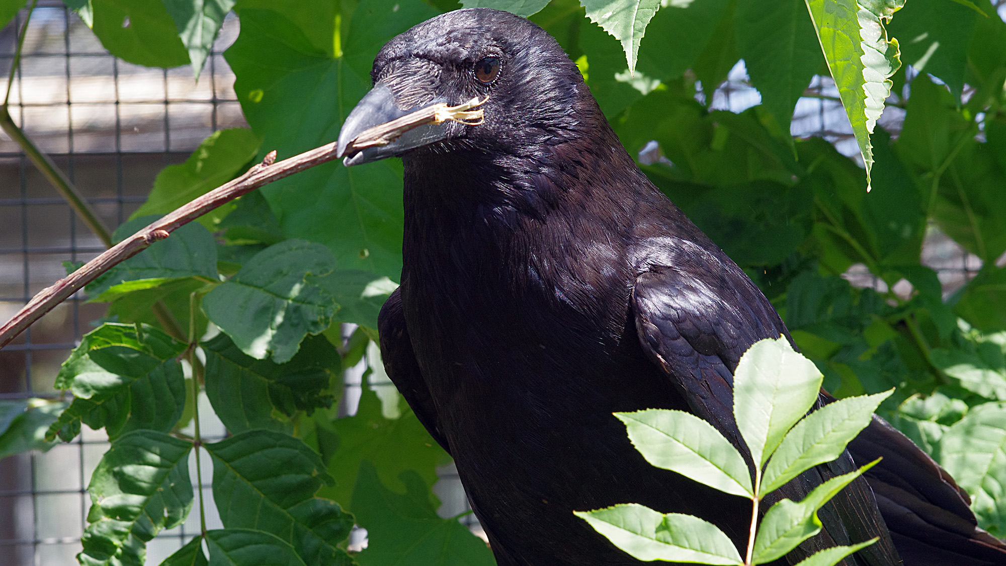
Crows use tools like tree branches to pick out bugs from hard-to-reach areas. (Image credit: Andreas Nieder)
KHC: You've also found that crows can perform statistical analysis. Tell me more about these findings and what you showed.
AN: We trained carrion crows [Corvus corone] to associate a series of arbitrary visual signs, colored geometric images displayed on a touch screen, with different reward probabilities. One sign might yield a food reward 90% of the time, another 70%, another 50%, and so on down to 10%. Importantly, the signs themselves carried no inherent meaning; the birds had to learn these probabilities through experience.
Once the birds had learned these sign-probability associations, we presented them with pairs of signs and asked them to choose one. To maximize their rewards, they should select the sign associated with the higher reward probability. The crows did exactly that. Even when confronted with many novel pairings, they reliably chose the statistically more favorable option.
This does not mean that crows perform formal statistics in the human sense. They are not calculating percentages or solving probability equations. However, the results show that they can extract probabilistic regularities from experience, store this information in memory, and use it flexibly to make reward-maximizing decisions under uncertainty. These are fundamental ingredients of statistical reasoning and are highly valuable in natural environments, where animals constantly have to make decisions based on incomplete information.
KHC: Have researchers tried similar tests on babies or young humans, and if so, how do we stack up?
AN: Yes. Developmental psychologists have conducted many related studies with infants and young children. Even before learning language, infants show sensitivity to quantities, numerical differences and simple probabilistic information. By around 4 years of age, children also display an intuitive understanding of empty sets.
What is striking is that the behavioral signatures observed in crows resemble those seen in preverbal human infants and nonhuman primates. Of course, human children eventually develop symbolic mathematics through language, education and culture, which takes them far beyond the abilities observed in animals.
KHC: Can these findings tell us anything about how the human understanding of math evolved?
AN: They suggest that some foundations of mathematics may predate humans by a very long evolutionary timescale. Humans did not invent numerical intuition from scratch. Rather, we appear to have inherited ancient cognitive systems that allow brains to estimate quantities, compare numbers, and represent concepts such as zero approximately.
The fact that crows and primates — two distantly related groups — show similar numerical abilities suggests that these capacities may emerge whenever evolution favors flexible intelligence. Human mathematics likely built upon these ancient cognitive foundations and then expanded dramatically through language, symbols and culture.
What is striking is that the behavioral signatures observed in crows resemble those seen in preverbal human infants and nonhuman primates.
Andreas Nieder
KHC: What's something a general audience might be surprised to learn about crows?
Many people are surprised to learn that crows are songbirds. Most people associate songbirds with melodic singers such as nightingales or blackbirds, not with the harsh cawing of a crow. Yet crows do learn a significant part of their vocal repertoire and are even known as apt imitators, even of human speech sounds — the internet is full of funny videos in which crows imitate human speech.
What makes this particularly interesting is that their vocalizations are not merely reflexive calls. In our experiments, we found that crows can exert volitional control over their vocal behavior. They can learn to produce vocalizations in response to arbitrary cues and withhold them when required, demonstrating a level of cognitive control over vocal output that is considered an important prerequisite for complex communication and, ultimately, language.
More recently, we showed that crows can even use their vocalizations to count. In a recent study published in [the journal] Science, we trained crows to produce a specific number of calls — between one and four — in response to visual or auditory cues. Remarkably, they not only generated the correct number of vocalizations but also appeared to prepare the intended number before they started calling. This suggests that they can represent numerical information and use it to guide a self-generated sequence of vocal actions.
Taken together, these findings show that crow vocalizations are far more sophisticated than most people assume. Their characteristic "caw" is not just a simple call — it can be brought under deliberate cognitive control and even used to express numerical information. For a bird, that is a remarkably advanced ability.
This interview has been edited for length and clarity.
Taming Nature: Inside China's efforts to control the region's water
China is facing water scarcity that affects millions of people, so the country is embarking on water projects on a scale the planet has never seen. This three-part series investigates three elements of this effort: the world's biggest dam, a doomed effort to create a "river in the sky," and a colossal water transfer project.
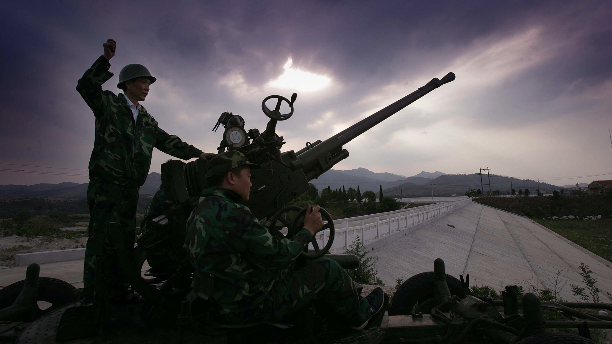
In southwest China, Chinese soldiers load and fire rockets toward the sky as aircraft and drones circle overhead, dropping their toxic cargo into the air. The weapons are not trained on an enemy, and the planes aren't dropping bombs. Instead, they are targeting the clouds hovering in the sky.
This footage is just a tiny snapshot of the massive, countrywide effort to seed the clouds with rain at an unprecedented scale.
More than 50 countries around the world use cloud seeding to modify the weather at small scales, including the United States.
China has been using and expanding cloud seeding for decades. This images from 2011 shows cloud-seeding shells being fired into the sky in Hubei Province, central China. (Image credit: Getty Images)
But China is the world leader, employing around 50,000 people; using thousands of rocket launchers and dozens of planes; and investing the equivalent of billions of dollars in these initiatives, experts told Live Science.
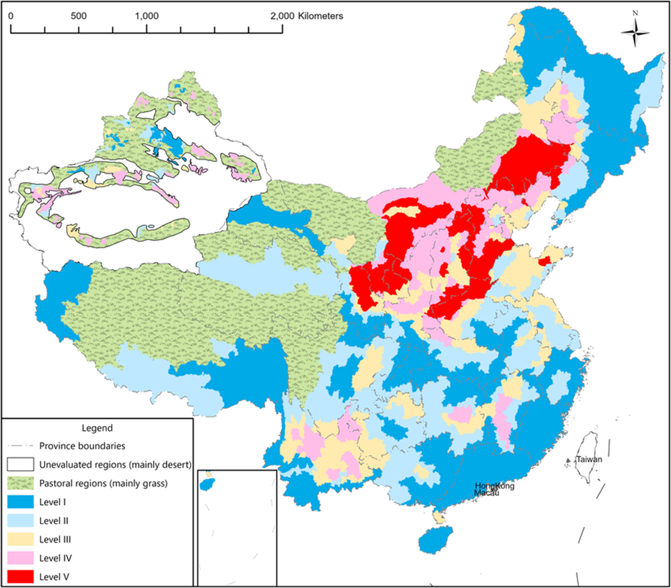
In 2018, China embarked on its most ambitious cloud seeding plan. The Tianhe ("Sky River") project aimed to create a permanent airborne water "corridor" from one river basin to another on the Tibetan Plateau. The project was intended to be part of the country's much bigger South-North Water Transfer project — a massive effort to transfer water to China's highly populated and water-scarce North and East.
From the start, the Sky River faced scathing criticism from scientists who said the project was unworkable. Yet China forged ahead.
China's pursuit of such a scientifically questionable geoengineering technology shows just how far Chinese authorities are prepared to go to achieve the country's water and climate goals. It also reveals how the Chinese government views the natural world, experts have said.
"There is an impetus to control and to view the environment as a machine or an infrastructure that can be controlled," Emily Yeh, a professor of geography at the University of Colorado Boulder, told Live Science.
The science of cloud seeding
China uses cloud seeding to produce precipitation to build up snowpack, help alleviate droughts, reduce the impact of hailstorms, and create skies clear of clouds and pollution for official events — as it did most famously during the 2008 Beijing Olympics, experts told Live science.
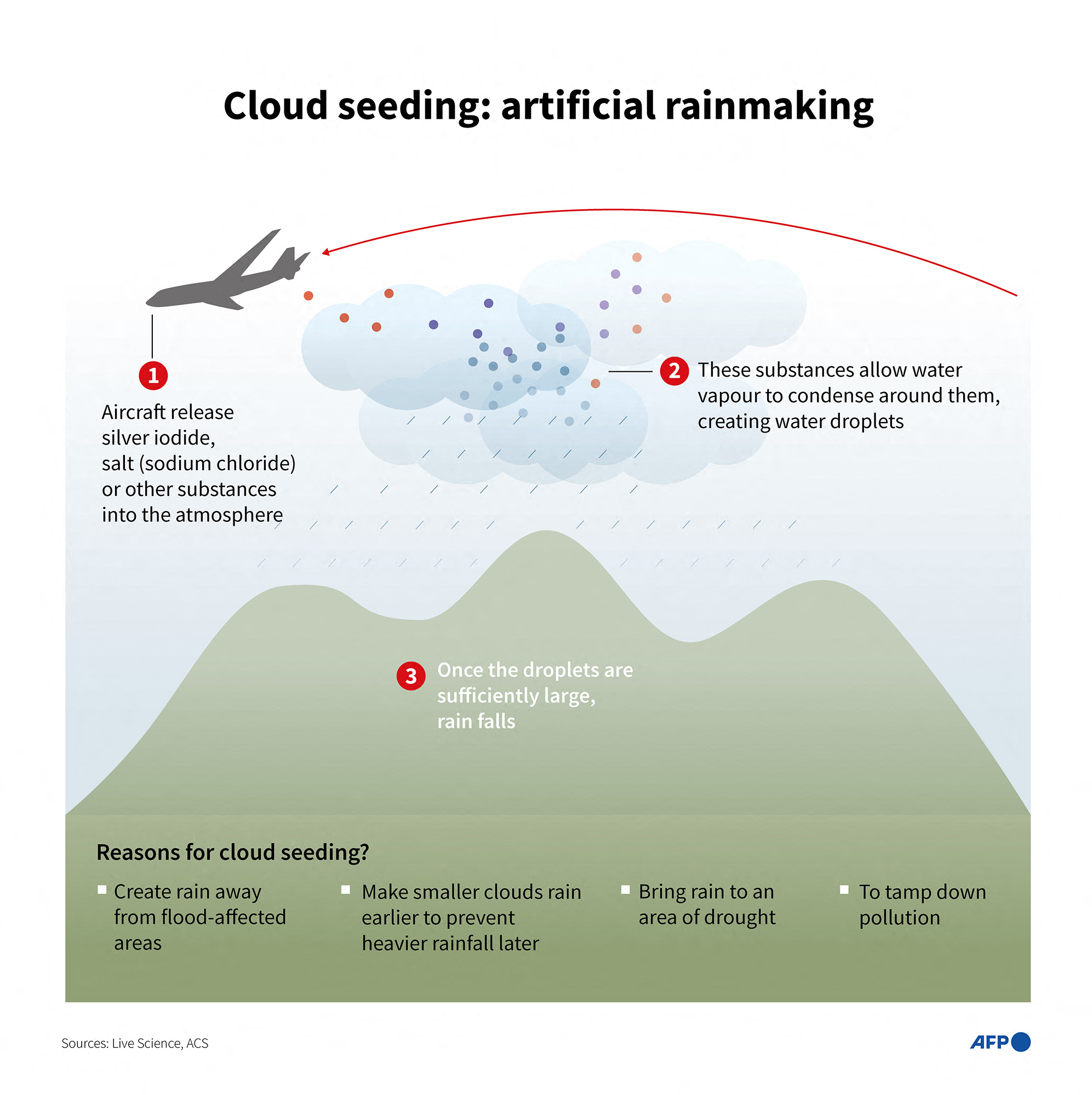
But cloud seeding can't create rain from an empty sky. Instead, it causes existing clouds to generate precipitation more efficiently by injecting particles into a cloud. Water droplets then coalesce around these particles, and the water eventually falls as rain or snow.
"Every single drop in any cloud you have ever seen — there's a particle in it," Rob Rauber, an atmospheric scientist at the University of Illinois Urbana-Champaign, told Live Science. Cloud seeding speeds up the raindrop-forming process by introducing more particles, he explained.
This illustration shows, in simple terms, how cloud seeding works. (Image credit: LAURENCE CHU via Getty Images)
There are two main ways to do this, depending on whether the temperature of the clouds is above or below 32 degrees Fahrenheit (0 degrees Celsius). Warm-cloud seeding is known as hygroscopic seeding, while cold-cloud seeding is called glaciogenic seeding.
"They have the same general goals or approach," Jeff French, head of atmospheric science at the University of Wyoming, told Live Science. "And that is to introduce something into the cloud that would increase the efficiency in which cloud droplets or ice crystals are able to grow to precipitation-size particles and fall out of cloud either as rain or as snow."
A salt such as sodium chloride is typically used for hygroscopic seeding to attract water droplets, French said. Glaciogenic seeding, by contrast, takes advantage of cold clouds' supercooled water — water that is liquid even when temperatures are below freezing — by introducing silver iodide. This substance has a similar structure to ice and collides with supercooled water in a cloud, causing it to freeze and eventually fall from the cloud, French said.
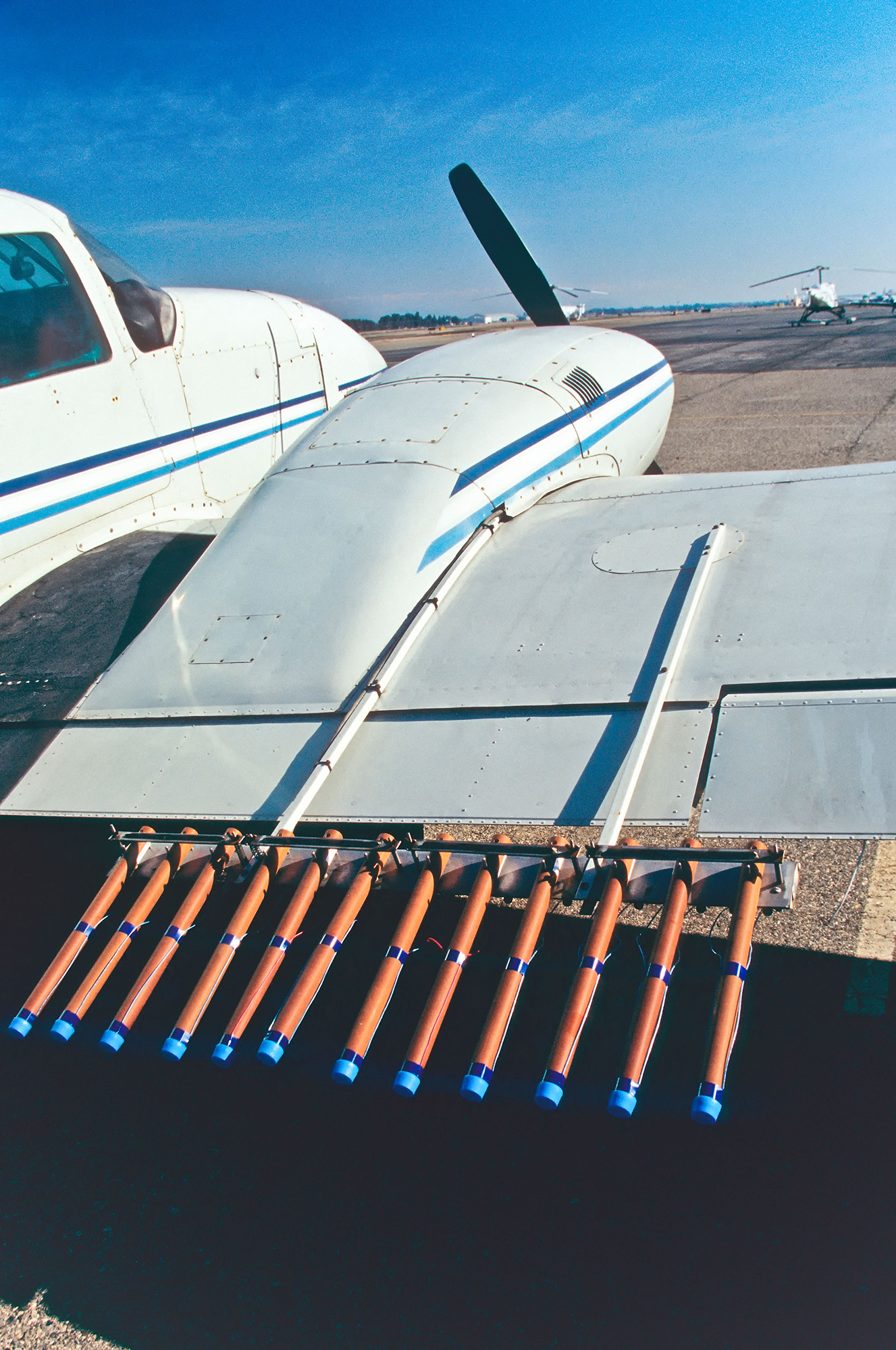
Scientists insert seeding particles into clouds in a number of ways, including by dropping them from planes and drones, firing shells or rockets into the clouds from the ground, or burning materials in chambers that release the combustion byproducts into the air.
Scientists are still learning exactly when and how to use these techniques most effectively. Rauber and French both noted that it's difficult to quantify cloud seeding's impact.
"It becomes kind of a quagmire when you ask that question: 'Does cloud seeding work?'," French said. For his research, he used airplanes, ground sensors and radar across the U.S. Mountain West to measure the effects of seeding from aircraft on the initiation and growth of crystals and eventual snowfall. "From a physical standpoint, I can say very confidently that cloud seeding works," French said.
However, that experiment was in cold, mountainous conditions, and the impact of cloud seeding depends on many conditions, so tracking whether cloud seeding increases precipitation over a longer period and in different conditions can be challenging.
Science Spotlight
(Image credit: Marilyn Perkins / Future)
Science Spotlight takes a deeper look at emerging science and gives you, our readers, the perspective you need on these advances. Our stories highlight trends in different fields, how new research is changing old ideas, and how the picture of the world we live in is being transformed thanks to science.
"Not all clouds are created equal," French said. Some are colder or warmer, and the seeding material won't work as well; in others, the size or distribution of droplets makes precipitation less likely. Even within a small region, the snowfall varies tremendously from one point to another. And beyond a small region, all bets are off.
"If you have a very successful cloud seeding program, that is producing, maybe 7% or 9% or even 10% more precipitation over a mountain range, downstream of that mountain range, the impact may be 1%," French said. "But it is a really difficult number to get our arms around."
French added that scientists should be careful to not overpromise what cloud seeding can accomplish.
"If the promise is that cloud seeding is going to eliminate droughts even on a local level, the answer is no, it can't live up to that. There's no scientific evidence," French said. But if targeted properly, it can moderately increase natural precipitation, he said.
Cloud seeding on the Tibetan Plateau
Despite cloud seeding's limitations, China has established weather modification bureaus across the country.
"They have a whole campus of people who are working in the weather modification field," Rauber said. "They have a fleet of aircraft — they're on a whole different scale than anything that goes on anywhere else in the world."
Chinese researchers claim that the country has made huge strides in its weather modification. Reports from state-owned media suggested that weather modification efforts increased precipitation by 168 billion tons between 2020 and 2025, and that in experiments, just one cup of cloud seeding material generated 30 Olympic-size pools' worth of precipitation over an area the size of Yellowstone National Park in the arid Xinjiang region.
A map showing water scarcity in various regions of China. (Image credit: Kong et al. (2021), CC BY-NC-ND 4.0)
These weather modifications have also been conducted on the Tibetan Plateau. The vitally important region, nicknamed Asia's Water Tower, is the source of multiple major rivers that supply water to nearly 2 billion people across Asia. But the plateau is facing increasing desertification and glacier loss due to human-caused climate change and other human activities such as overgrazing animals.
China's cloud-seeding ambitions for the plateau reached a whole new level in 2018, when authorities announced the Sky River project. The controversial project aimed to use cloud seeding to create precipitation across a 620,000-square-mile (1.6 million square kilometers) area in the Tibetan Plateau — about the size of Alaska — to divert Indian monsoon rains above the Yangtze River basin and channel the water to the Yellow River basin. From the Tibetan Plateau, the Yellow River flows north and east into the parched northern regions of China, while the Yangtze flows south and east into less-water-scarce areas. The initial plan claimed the project would transfer up to 7% of the country's total annual water consumption, reports noted.
The atmospheric channel was intended to be part of the country's colossal South-North Water Transfer Project, circumventing the region's challenging terrain by moving the water in the sky instead.
The plan, due to be completed in 2025, called for seeding this atmospheric river using tens of thousands of silver iodide-burning chambers on the ground, linked to a series of meteorological satellites that would analyze the weather conditions. Information from these satellites would automatically trigger the burners when the conditions were suitable for cloud seeding.
Cloud seeding takes place in more than 50 countries, including in the U.S. Here, a plane in California is about to take off with pyrotechnic silver iodide flares. (Image credit: inga spence via Alamy)
However, the plan was immediately met with a barrage of criticism from scientists in China. In a translated statement, Hancheng Lu, a professor at the National University of Defense Technology's School of Meteorology and Oceanography, called the project "an absurd and fantastical project with neither scientific basis nor technological feasibility."
The project was unworkable because it is not possible to convert all atmospheric moisture to rain, or to channel moisture in this way, Yeh said.
As of 2022, researchers were working on a significantly scaled-back version of the project. However, China's official channels have gone dark on the topic.
China's newly announced five-year plan, which sets out the policy direction of the country from 2026 to 2030, references weather modification enhancements but doesn't mention this specific project, according to reports from Chinese media.
This has led experts to speculate that the project was quietly canceled.
"When one goes to China and asks atmospheric scientists not involved in it about it, they just sort of laugh, and it's like this embarrassing incident," Yeh said. "It was never possible."
To see whether the project was still going forward, Live Science reached out to several researchers involved in the project, but they did not reply by the time of publication.
The fears of cloud seeding
The pursuit of the Sky River project — despite the low likelihood that it would ever work —— has caused significant alarm in neighboring countries. India relies on the monsoon rains and rivers such as the Brahmaputra, which starts in the Tibetan Plateau before flowing through India and Bangladesh on a 1,800-mile-long (2,900 km) route to the sea. There are also suspicions about cloud seeding being used to cause flooding across borders.
Many of these fears are overblown, experts told Live Science. Rauber noted that cloud seeding can't influence weather enough to reduce water in a wider weather system.
"This is always a question of, 'Are you robbing Peter to pay Paul?'" Rauber said. But the amount of water in storm clouds "is way greater than anything cloud seeding is going to extract."
Climate geoengineering
China's all-in pursuit of technologies like cloud seeding — even on the internationally important and politically sensitive Tibetan Plateau — has raised concerns that China is prepared to go to extreme lengths to engineer its way out of its problems — even when it involves scientifically dubious geoengineering projects with massive risks.
This may even involve attempts to change how much sunlight reaches the planet's surface, experts have speculated.
"Given similarities, weather modification could serve as a means to incrementally build legitimacy for solar radiation management, in China and beyond, which may ultimately make it possible to deploy it," researchers argued in a 2019 study.
However, there's no evidence that China is currently pursuing such climate modifications, and it's unlikely they'd do so without some cooperation or buy-in from other countries, researchers wrote in 2023.
"It is currently unlikely that China would deploy SRM unilaterally. But its weather modification programme does demonstrate the country's willingness and capability to undertake large-scale atmospheric intervention projects," the study authors wrote.
Solar radiation modification aims to release particles such as sulfur high into the atmosphere to reflect sunlight back into space in an effort to limit global heating. It is being increasingly investigated by researchers and governments. The controversial concept has never been demonstrated on a large scale, and studies suggest it has many potential risks, such as the potential to shut down monsoon rains.
Scientists have already seen some of the negative impacts of natural solar radiation modification, for instance in the aftermath of large volcanic eruptions, such as Tambora in 1815. "It led to the suppression of the monsoon, because the monsoon is driven by heating from the sun, Rauber said. "And that cuts back on rain in tropical areas, and that causes droughts, which causes all sorts of diseases and can lead to mass starvation," he added.
"The evidence from nature is don't mess with Mother Nature," he said.
The symptoms: In March 2020, the woman developed a high fever, chest tightness, shortness of breath and diarrhea, and she lost her sense of smell and taste. She also experienced coughing fits so intense that they caused her to faint. Based on these symptoms, her primary care provider diagnosed her with COVID-19, although she was not formally tested for the illness due to the lack of diagnostic testing available at the time.
After her diagnosis, she did not seek further medical care due to concerns about out-of-pocket costs, according to a report of the case.
What happened next: Three weeks after her symptoms started, the patient felt well enough to work from home. However, four weeks after that, many of her symptoms returned. She also noticed new feelings of disorientation and felt that "something was off with faces." Her primary care doctor suggested she go to an emergency room, where a CT scan was taken of her brain. The scan didn't show any active bleeding, the report notes, and she was discharged.
In June 2020, the patient spent time with family for the first time since catching COVID-19 and found she could not recognize her father or visually distinguish him from her uncle. She still recognized people by their voices, though.
The patient worked part time as a portrait artist; she used to be able to check her reference photos every 15 to 30 minutes but found she now struggled to hold the details in her mind. She told doctors that "faces are like water in my head," according to the case report.
The patient also had trouble doing everyday tasks, such as navigating her local grocery store or finding her way back to her car in a parking lot. In November 2020, she also started having balance issues and frequent migraines.
The diagnosis: Based on her wide-ranging and relapsing symptoms and her suspected history of COVID-19, doctors diagnosed the patient with post-acute sequelae of COVID-19 (PASC), now known as long COVID. They diagnosed her difficulties with recognizing faces as "face blindness," or prosopagnosia.
Roughly 2.5% of the general population is thought to be born with some degree of face blindness, while others can acquire the condition later in life. The exact number of people with acquired prosopagnosia is unclear, but some estimates suggest roughly 1 in 30,000 people in the U.S. are affected.
Many people with acquired prosopagnosia also have issues navigating familiar spaces. That was also the case with this patient, likely due to the "proximity of brain regions critical for scene and face processing," the case report authors noted.
SARS-CoV-2, the virus behind COVID-19, can trigger a wide range of neurological effects. (Image credit: loops7 via Getty Images)
To assess the extent of the patient's prosopagnosia, doctors had her complete several tests of facial memory, which asked her either to memorize strangers' faces or recognize celebrities' faces. The patient performed markedly worse on these tests than 10 women of similar age who were used as a comparison group.
However, she performed as well as the comparison group on other types of cognitive tests, suggesting her deficits were fairly specific to faces. She also got normal scores on tests of facial perception — the ability to recognize that a face is a face — so her face blindness seemed tied more to memory deficits for faces, the report authors said.
The treatment: The case report does not detail a specific course of treatment, and in general, few treatments exist for face blindness. If there's a clear cause for the deficit — such as a tumor in a key part of the brain for facial processing — addressing that underlying issue can help reverse acquired face blindness.
If the condition ends up being permanent, there are various strategies that can help patients cope. For instance, "perceptual training" can improve patients' ability to identify and remember the features of a person's face. Additional strategies include training people to use other cues, like voices and social context, to identify people.
The 28-year-old woman, by contrast, wasn't thought to have suffered a stroke, and it's unclear exactly how COVID-19 led to her facial processing issues.
The case report authors surveyed more than 50 other people with long COVID, to see if they also had signs of face blindness. While many showed general declines in visual recognition and navigational abilities, the group didn't have a specific problem with faces. So while long COVID is known to cause a range of neurological issues, it appears that face blindness is a rare consequence.
Archaeologists in Germany have unearthed an unusual burial of an injured man who was thrown into an abandoned kiln nearly 5,000 years ago. Because archaeologists don't typically find artifacts or bones in kiln pits, they suspect the man may have been a human sacrifice.
While workers were constructing a power line near Gerstewitz, a village in central Germany, archaeologists found a Corded Ware culture grave, according to a June 15 statement from the State Office for Heritage Management and Archaeology (LDA) Saxony-Anhalt.
The Corded Ware culture, named after the distinctive cord-like impressions found in their pottery, spread across Northern Europe between the Late Neolithic and the Bronze Age, around 2900 to 2050 B.C. Graves of Corded Ware people tend to follow a strict pattern: Men were buried on their right side, women were interred on their left, and everyone was buried in a crouched position facing south. But sometimes, graves deviate from this pattern.
The newly excavated grave at Gerstewitz revealed the skeleton of a man who was about 25 years old when he died. He was buried in a crouched position facing south, but rather than being placed in a grave or under a small mound, he was found in a kiln pit. This pit, essentially a hole that had been dug into the ground, held ancient evidence that people had used it to burn material, such as wood or food, or to fire clay. Additionally, the man's skull showed signs of injury.
Experts have suggested three possible explanations for the unusual burial. The skull injury may have resulted from violence, meaning someone murdered the man. Alternatively, he could have perished in a Copper Age battle lost to history. But a third possibility is that he was placed in a kiln pit as a human sacrifice.
The man buried in the kiln pit sustained an injury to his head before he died. (Image credit: dpa Picture-Alliance)
Oliver Dietrich, an archaeologist at LDA Saxony-Anhalt, wrote in the statement that, in rare cases, Corded Ware kiln pits contain cow or dog bones thought to be sacrificial offerings to unknown deities. While it's possible this man was a human sacrifice, Dietrich noted that future laboratory analysis should provide more information about the grave and the person buried there.
This is not the first time a sacrificial pit has been found in Gerstewitz. Last year, archaeologists with LDA Saxony-Anhalt discovered 12 pits ringed by a moat-like ditch. The pits were full of dog bones, human skulls and complete ceramic pots and had been sealed with the rubble of burnt houses, according to a 2025 statement about that discovery. An additional human skeleton was found buried in a converted oven pit. These finds, however, were attributed to the Salzmünde Culture (3400 to 3050 B.C.), which predated the Corded Ware people.
Other discoveries near Gerstewitz have revealed that the area was settled and occupied for over 6,000 years. The excavation there will last until at least 2027, when the power line project is expected to be completed.
What do you know about the Paleolithic, Mesolithic and Neolithic eras? Find out with our Stone Age quiz!
Today (June 17), for the first time in 11 years, people across North America will be able to look up in the daytime sky and see Venus temporarily vanish behind the faint crescent moon.
The rare skywatching spectacle can be viewed with the naked eye and recorded without any special equipment, as long as the weather cooperates — however, using a good pair of binoculars or a backyard telescope will make it much easier to see the faint light of Venus in the daytime sky. No matter how you go about skywatching, you must take great care not to stare directly at the sun while doing so.
During the event, known as a lunar occultation, the moon will briefly pass between Earth and Venus, which has been shining especially bright over the past few weeks while hanging out alongside Jupiter in the evening sky. As a result of the occultation, the hellish planet will appear to blink out of existence, before reappearing around an hour later, allowing for two separate skywatching experiences. The last time this happened was on Dec. 7, 2015, and you will not be able to see it again until 2029.
How to see Venus disappear
The occultation will be visible from the 48 contiguous U.S. states, as well as from large parts of Canada and some countries in the northern half of South America — assuming there are clear skies at the time of the event. (The latest forecast suggests that weather conditions will be most favorable along the West Coast.)
As with most skywatching events, such as solar eclipses, not everyone will see it at the same time. For example, people in San Francisco will observe Venus vanish at around 11:34 a.m. PDT, while those in Miami will watch the planet disappear at about 4:06 p.m. EDT (around 92 minutes later when disregarding time zones).
The duration of the occultation will also vary with location. For example, Venus will reappear after around 58 minutes for viewers in San Antonio, but people in Philadelphia will have to wait roughly 80 minutes to see the planet again.
The best place to watch both the disappearance and reappearance of Venus will be from within the shadow of a large tree or building. Blocking out the sun will not only make it easier to see both the moon and Venus but also reduce the risk of sustaining eye damage by looking directly at the sun.
If you are struggling to see the occultation, try using your phone camera to zoom in on the waxing crescent to better locate and record Venus, Spaceweather.com recommends.
What the June 17 lunar occultation will look like
During the event, around 11% of the moon will be faintly visible in the daytime sky, according to Sky & Telescope. Around three-quarters of Venus will be visible — although it will look like a single spot to the naked eye — so the planet will shine much brighter than the moon. The pair will be collectively located around 38 degrees from the sun in the sky.
Venus will vanish behind the side of the moon opposite the illuminated crescent and will take around 30 seconds to disappear completely. It will then reappear above the crescent, similar to the iconic "Earthrise" photos taken by lunar astronauts, such as the Artemis II crew. (The exact spot where Venus disappears and reappears will depend on where you are in the world.)
If you miss this occultation or fancy another skywatching spectacle, be sure to head back outside later the same day, around an hour after sunset, when Venus, Jupiter and Mercury will shine alongside the crescent moon as it passes in front of the Beehive Cluster (also called M44).
A colossal chunk of sea ice roughly the size of Texas is missing from the west coast of Antarctica, and scientists fear it might never form again.
Antarctica is currently in winter, which runs from March to October on the southernmost continent. During the winter months, floating sea ice surrounding the continent typically grows, driving currents that regulate Earth's climate. But this year, there's a notable ice gap over the Bellingshausen Sea, on the western side of the Antarctic Peninsula.
Satellite observations have revealed that around 250,000 square miles (650,000 square kilometers) of sea ice hasn't formed yet, compared with the average amount of sea ice between 1991 and 2020, The Guardian reported last week. For comparison, the ice gap covers an area slightly larger than France or nearly the size of Texas.
Will Hobbs, a sea ice-ocean interaction scientist at the University of Tasmania, told The Guardian that he was "concerned" by the lack of sea ice and that it was "depressing." Hobbs noted that this year represents the third time in four years that the region's sea has been very low.
"I don't think we will see sea ice there any more," he said. "It's done."
Researchers still have a lot to learn about sea ice changes in Antarctica. Hobbs said that the sea ice loss was likely linked to changes in the ocean and that scientists are trying to determine whether global warming was a factor.
Sea ice has declined much more slowly in Antarctica than in the Arctic. But in recent years, scientists have been witnessing an astonishing change in the sea ice extent. One record low in 2016 was followed by another in 2022 and then a third in 2023.
Edward Doddridge, a physical oceanographer at the Institute for Marine and Antarctic Studies in Australia, told ABC News (Australia) that he was no longer surprised by sea ice loss.
"It's not good news, but it has become a pattern that we're expecting now," Doddridge said. "A warming world is going to have less sea ice."
The diminished winter sea ice is likely to have a variety of knock-on effects. For example, this area of sea ice normally provides important habitat for animals like krill and penguins. Sea ice also plays an important role in regulating the climate, including by driving key ocean currents, insulating the ocean from the sun, and protecting ice shelves at the mouths of glaciers.
Down the coast from the missing sea ice, researchers have warned that a key ice shelf is about to disintegrate from Antarctica's Thwaites Glacier — nicknamed the "Doomsday Glacier" because its collapse could raise sea levels by 2.1 feet (65 centimeters) in the coming centuries, flooding coastal communities worldwide. The ice shelf helps protect the mouth of the glacier by acting as a buttress, thereby restraining the flow of ice from the glacier into the sea.
Thwaites Glacier has been melting rapidly since the 1980s, which is part of a wider concern for the West Antarctic Ice Sheet that it helps to support. The collapse of such an ice sheet is considered one of the major environmental tipping points, or "points of no return," that humanity must avoid in the fight to rein in climate change.
The wreck of a Japanese prison ship that was sunk by U.S. warplanes and went down with more than 1,000 Allied prisoners of war in 1944 has been discovered in the Philippines.
The vessel was one of the notorious "hellships" used by the Japanese to ferry POWs between work camps. Many of the prisoners who died when the ship sank had worked on the infamous Burma-Thailand "Death Railway."
"Sadly, a lot of these prisoner transport ships were sunk by the Allies," expedition leader and American TV show host Josh Gates told Live Science. "The ships were painted to just look like military vessels, and they were inside the Japanese convoys — so the Allies thought they were legitimate military targets."
Gates teamed up with the Hellships Memorial Foundation, a U.S.-registered non-profit based in Subic Bay in the Philippines, to investigate the sinking of the hellship Hōfuku Maru. Its wreck had never been found, probably because searchers were guided by incorrect U.S. records to look too far north, he said.
But Japanese wartime records were more precise about the wreck's location, helping the team find the remains of the Hōfuku Maru in January, Gates said. His team has since made five dives to the wreck, which sits a few miles off the west coast of the main Philippines island of Luzon at a depth of about 160 feet (50 meters).
The newfound wreck lies a few miles from the coast of the main Philippines island of Luzon, northwest of Manila. (Image credit: Evan Kovacs, Marine Imaging Technologies, LLC)
Prison ships
Japan used more than 130 hellships during World War II, but the wrecks of only a few have been found. Many hellships, including the Hōfuku Maru, were converted freighters. The Hōfuku Maru was used as a prison ship from 1942 until its sinking about two years later.
Gates said the vessel was part of a Japanese military convoy sailing from the Philippines to Japan when it was attacked on Sept. 21, 1944. U.S. warplanes had spotted the convoy, and one dropped a torpedo that cut theHōfuku Maru in half. It quickly sank.
But the ship had roughly 1,200 Allied POWs on board, from the British and Dutch armies, many of whom had been forced to work on the Death Railway. Some were able to swim ashore, but they were recaptured by the Japanese. About 1,040 died in the sinking, Gates said.
Mapping with an underwater drone has identified three separate sections of the wreck. (Image credit: Evan Kovacs, Marine Imaging Technologies, LLC)
War captives
The 1929 Geneva Convention placed strict limits on the use of prisoners of war for labor, but Japan was infamous for flouting these rules during World War II, claiming that it never ratified the convention and that wartime made POW labor important. Japan used POWs for slave labor on railways and docks, as well as in factories and mines. Of the roughly 132,100 prisoners captured from the United States and United Kingdom armies, nearly a third of them — about 35,000 people — died of exhaustion, malnutrition and disease.
Gates said the Japanese hellships used to ferry thousands of POWs between work camps were miserable places themselves: there was little light, air or food, and prisoners might be kept there for months. Human remains have been identified on the newfound wreck, and it will now be considered a war grave, he said. International conventions aim to prevent such wrecks from being disturbed.
The team first spotted the wreck with sonar, and then dove to identify parts of the structure that confirmed it as the Hōfuku Maru. They also mapped the wreck with a remotely operated underwater vehicle, which helped them determine that the ship had split into separate parts, just as accounts of the sinking had reported.
The Hellships Memorial Foundation would now work to try to locate the families of the victims, Gates said.
At age 19, John McFall thought he might never walk again after his right leg was amputated above the knee following a motorcycle accident. Fast-forward more than two decades, and he is now on the verge of becoming the first physically disabled person in space.
McFall, 45, is a British surgeon and former Paralympic athlete who won multiple medals as a T42-class sprinter. In 2022, he joined the European Space Agency's (ESA) Fly! program, which aimed to see if a person with a physical disability could live and work in low Earth orbit. And in February 2025, he became the first member of the program to be cleared for a potential future mission to space.
More recently, on June 2, the U.K. government announced that McFall had been selected as a prospective member of the first crew to live on Haven-1, an upcoming commercial space station from U.S. company Vast that is scheduled to be the first of its kind in low Earth orbit, if it launches on time early next year.
If everything goes according to plan, the roughly 30-day mission will help answer a series of interesting questions about how living in space might be both challenging and advantageous for people with physical disabilities.
Live Science spoke with McFall about what it would mean to break new ground, wearing a prosthesis in space and how microgravity might uniquely affect him.
Harry Baker: How did it feel to get the news that you might be going to space next year?
John McFall: Awesome. Very awesome, very exciting. And it feels like we're one step closer to realizing this amazing opportunity and achieving this very exciting milestone in human space exploration.
HB: What would it mean to you personally to become the first physically disabled astronaut in space?
JM: To me personally, it doesn't make a difference. In terms of "what an achievement for me," I don't tend to think of it like that. However, I am very aware that the broader message that it sends to wider society about what people are capable of — whether they have a disability or not — is very interesting and powerful. So I'm proud to be a very small part of that movement, if you like, and the journey of making society a more tolerant and inclusive place.
McFall (far right) joined ESA in 2022. This photo shows him alongside some of his fellow Class of 2022 astronauts at an event in Paris the same year. (Image credit: JOEL SAGET / AFP via Getty Images)
HB: What advantages do you think your disability might give you in space compared with other astronauts?
JM: It's a good question because we don't actually know. We can hypothesize, but until we actually get into space and conduct some science that's specifically relevant to my disability, we won't know. But there are some theoretical benefits.
One is that when you live in microgravity, you get a shift of fluid from the lower part of your body up into the upper part of your body and your cranium. This can cause swelling of the optic disk, which can temporarily affect vision. It's called spaceflight-associated neuro-ocular syndrome (SANS), and it affects around 70-75% of astronauts. I would hypothesize that, having a reduced lower limb volume to start with, you're going to get a proportionally smaller fluid shift in microgravity, relative to your physiological capacity to process it, reducing the risk of things like SANS.
Another is that in microgravity, because you're weightless, you're not using your bones as much, and your body naturally resorbs them. So your bones get weaker and thinner. And one of the byproducts of this is that you have to excrete a lot of calcium, and you do this via peeing it out. As it [calcium] passes through your renal system, or kidneys, this causes an increased risk of kidney stones in microgravity. So again, having lower bone mass to start with — but retaining the same physiological capacity to metabolically process calcium — there is potentially a lower risk of kidney stones.
Haven-1 is scheduled to be the first ever commercial space station. It will launch in early 2027 and could host its first astronauts, including McFall, later the same year. (Image credit: ESA/Novespace)
So those are two small-but-hypothetical benefits of my particular disability in space. But the real answer is, we don't know until we do the science (i.e., urine samples, blood samples and eye examinations in orbit).
HB: How might space be more challenging for you than for other astronauts?
JM: Again, we don't know. The question is, do you really need both your lower limbs to help you stabilize and support yourself whilst your hands are doing tasks? And is having two legs useful in what we would call normal intravehicular operations [conducted inside the spacecraft], whether it be cargo operations, maintenance, this sort of stuff?
When we went through the feasibility initiative, trying to think of and work out all these scenarios, we couldn't really think of a disadvantage other than maybe having to work slightly harder.
HB: Will you be wearing a prosthesis in space?
JM: The plan is to wear a prosthesis. We deemed quite early on that wearing a prosthesis in a spacecraft would be a necessity, mainly at launch time. If there was an emergency that required me to get out of the spacecraft and get off the crew access arm and away from the launch site, it would be ideal wearing a prosthesis to do that.
But in space, we don't know whether it's going to be an advantage or be required for these intravehicular activities. Where I would definitely need to use one is on a long-duration mission where I need to exercise lots. I use a prosthesis to exercise on Earth, and I would use a prosthesis to exercise in orbit. However, short-duration missions [like this one] do not.
McFall won several medals as a T42-class sprinter, including a bronze at the the 2008 paralympic Games in Beijing. (Image credit: Andrew Wong via Getty Images)
The prosthetics I use are modular, so I wear a socket — that's what's left of my leg goes inside — and then the hardware, what we call the terminal device, is attached to the socket. What I would envisage doing is always wearing the socket, because that way, you maintain consistency. But [for] the terminal device itself, I have a quick-change adapter that you can just unplug the device, and you can take it off and, likewise, put it back in again.
It's "plug and play," if you like, and [it will allow me to] make assessments of whether it's useful or not.
HB: Will your prosthesis need to be specially made for the trip?
JM: Not really. We are certifying a number of prosthetic hardware items to fly, but they're all what we call "commercial, off-the-shelf items." So they're products that are widely available.
However, there are some very small changes that we need to make to make them compliant with the safety requirements of the space station environment and the spacecraft, such as fireproof tape around certain parts of the device or changing the hydraulic fluid so it's less toxic in case there is a leak.
We're also doing a small amount of redesigning to the shape of the foot to make it more ergonomic to interface with things like rails and straps inside the space station, because you often slip your foot under rails and straps.
HB: Could anything you learn from your mission help physically disabled people back on Earth?
JM: Yeah, I think so, certainly from a prosthetics point of view. There are prosthetic developments that we have made that will benefit other prosthetic users in the future.
I mentioned this quick-change adapter. We have revised or reengineered this particular device to perform in a certain way, which I think will have advantages for a whole range of lower-limb amputees. The socket technology — the interface between my stump and the prosthesis — is [also] going to be redesigned and potentially has very beneficial applications for lower-limb amputees again.
McFall was cleared to fly to space last year. Before then, he featured in the opening ceremony for the 2024 Paralympic Games in Paris (photographed). (Image credit: Mauro Ujetto/NurPhoto via Getty Images)
HB: Are you hoping to be selected for more missions in the future? And would you like to become the first physically disabled person on the International Space Station (ISS) or the moon?
JM: Yeah, absolutely. I hope that we use this opportunity to demonstrate that it is very feasible, and I hope that that would put me in line for selection of missions in the future.
I would love to, in the future, potentially spend longer in space, demonstrating that it's possible for someone with a disability to live and work in space and cope with everything that comes with that.
And absolutely, I would love to go to the moon. You know, someone with a lower-limb disability, when you propose that against walking on the moon, it's quite a powerful statement, and I would love to do that.
Editor's note: This interview has been condensed and edited for clarity.
For decades, physicists have pursued a goal that sounds nearly impossible: to build a clock that keeps time using an atom's nucleus rather than the electrons orbiting it.
Now, researchers have demonstrated the first functioning nuclear clock — an advancement that could eventually lead to more robust timekeeping devices and new ways to search for dark matter and physics beyond the Standard Model.
"Having worked in this field for more than 15 years, it is just beautiful, how a very 'wild' idea such as manipulating an atomic nucleus with a laser has turned into reality," Thorsten Schumm, a professor of quantum metrology at the Vienna University of Technology and a member of the research team, told Live Science via email.
How is a nuclear clock different from an atomic clock?
Today's most accurate clocks are optical atomic clocks, which measure the frequency of electrons jumping between different energy levels inside atoms. These clocks are so precise that they would lose less than a second over a 100 million years.
A nuclear clock works similarly, but it uses a transition within the nucleus itself, where the nucleus jumps between energy levels. Because the nucleus sits deep inside the atom, it's far less affected by external disturbances from things like electric or magnetic fields. According to Schumm, the nuclear transition can be 1,000 to 10,000 times less sensitive to environmental noise than atomic transitions are.
A diagram showing how a nuclear clock works. (Image credit: N. Hanacek/NIST)
"This means that it would be easier to stabilize a nuclear clock over long periods of time," Jacob Higgins, a postdoctoral researcher at Northwestern University who previously worked on thorium clock experiments at JILA in Colorado but was not affiliated with the study, told Live Science in an email. "The transition used for the nuclear clock experiment has a higher quality factor than optical atomic clock transitions, which means that in principle, it can be measured more precisely given the same amount of measurement time."
Together, those advantages could allow nuclear clocks to outperform even today's best atomic clocks according to Higgins.
Why thorium-229 is special
The nuclear clock relies on a rare isotope called thorium-229, whose nucleus contains an unusually low-energy excited state that can be manipulated with ultraviolet laser light.
For decades, scientists had suspected thorium had a low transition, but identifying and controlling it proved extremely challenging. Researchers spent years testing different thorium-containing materials, laser systems and detection methods before finally pinning down the transition.
"It was a long road," Higgins said.
One key advancement was the development of continuous-wave lasers that operate at the precise wavelength needed to excite the thorium nucleus. Before those lasers existed, researchers had to excite the nucleus and then wait several minutes for it to decay and emit a detectable signal. That process was too slow to build a practical clock.
"With the continuous lasers, we can measure the nucleus in absorption and get an immediate response, whether the laser is still at the right frequency (and if not, correct it back)," Schumm said. "Once we had that, it was 'just' implementing some electronics and atomization to have the clock stabilize itself to the nucleus."
Thanks to this set-up, the researchers kept the nuclear clock running continuously for 24 hours.
Unlike many optical atomic clocks, which require ultracold atoms to be suspended in a vacuum chamber, the thorium nuclei are embedded inside a crystal at room temperature.
Because the thorium transition remains stable inside a solid material, researchers may eventually be able to build compact clocks that are useful for navigation systems, telecommunication networks and data synchronization.
NASA's Deep Space Atomic Clock, seen here in an artist's illustration, was launched in June 2019 to use atomic clocks in space. (Image credit: NASA)
A tool for studying the universe
Some physicists are more excited about what nuclear clocks could reveal about fundamental physics, rather than the clocks' timekeeping abilities.
Atomic clocks primarily probe electromagnetic interactions involving electrons. Nuclear clocks, by contrast, are sensitive to the strong nuclear force, weak nuclear force and electromagnetism — three of the four fundamental forces of the universe, along with gravity. This can make them useful detectors of new physics, in a way.
"The nuclear clock is foremost a different clock, ticking on different fundamental physics mechanisms," Schumm said. "Essentially all modern theories beyond the standard model predict additional particles or 5th forces … which can be probed with the nuclear clock in some parameter regime."
Thorium-229 is particularly intriguing because the energy difference between its two nuclear states results from a delicate balance between electromagnetic and nuclear forces. Because those large contributions nearly cancel each other out, even tiny changes in the underlying forces could shift the clock's frequency.
Researchers, including Higgins, have already used early versions of the clock to place constraints on some dark matter models, and they expect its sensitivity to improve as the technology itself gets better.
Although the first functioning nuclear clock is a major achievement, these timekeepers remain in their infancy. Scientists still need to gain a better understanding of how the thorium transition responds to factors like temperature and magnetic fields while developing more powerful and stable laser systems.
"I think it will be many years before the thorium clock can compete with today's best optical atomic clocks," Higgins said, "but we will learn a lot of new science on the pathway to getting there."
The San Andreas and San Jacinto fault systems are at their highest levels of tectonic stress in 1,000 years, raising the threat of a major, imminent earthquake that could devastate Southern California, a new study finds.
The faults could rupture separately or together, thanks to an "earthquake gate" between them at Cajon Pass, where the San Jacinto fault splits from the main trace of the San Andreas fault. Researchers discovered that Cajon Pass can prevent or facilitate earthquakes moving between the faults, depending on how similar their stress levels are at the time of rupture.
And right now, the San Andreas and San Jacinto faults appear to have comparable, extremely elevated stress levels, potentially spelling trouble for Los Angeles, San Bernardino, Riverside and the Coachella Valley, the team warned.
Cajon Pass, where the San Andreas and San Jacinto faults connect, is an "earthquake gate" that can facilitate the spread of ruptures. (Image credit: Burkhard et al., 2026. JCR Solid Earth. (CC BY 4.0))
"Our results show that stress levels on multiple fault segments are now at or above the highest values seen in the past millennium and that the region may be capable of a large through-going rupture involving both fault systems," study first author Liliane Burkhard, a planetary geologist at the University of Bern in Switzerland and at the University of Hawaii at Manoa, said in a statement.
The San Andreas and San Jacinto faults have caused 36 earthquakes with magnitudes of 6.4 or above in the past 1,000 years. Southern California's last "big one" was a magnitude 7.9 event in 1857, when a 205-mile (330 kilometers) segment of the San Andreas fault slipped horizontally between Parkfield and Cajon Pass. That rupture did not propagate through Cajon Pass, but a similar megaquake in 1812 did, suggesting this could happen again in what is now a much more built-up and densely populated environment, according to the study.
To estimate this risk, Burkhard and her colleagues built a model replicating the last 1,000 years of major earthquake activity along the southern San Andreas and San Jacinto fault systems.
The researchers used observations such as tree-ring records and age data from sediments that have been displaced to reconstruct Southern California's earthquake history. They fed this information into the model, which simulated the accumulation, release and propagation of tectonic stress in the San Andreas and San Jacinto faults.
The results, published June 3 in the Journal of Geophysical Research: Solid Earth, suggest the San Andreas and San Jacinto faults are primed for an Earth-shattering rupture, which may involve the earthquake gate at Cajon Pass opening to unleash more destruction than a single-fault event would on its own.
If a rupture were to occur along the two branches of the San Andreas fault that connect at Cajon Pass, it would be a joint rupture, according to the study. If both branches of the San Andreas fault and the San Jacinto fault were involved, this would constitute a tripartite rupture.
The chance of each event happening and the timing of a potential rupture are unknown, but understanding how much stress is building up inside the system could help planners and policymakers prepare for whatever comes next, Burkhard said.
"What we can say is that the system is critically stressed, and that physics-based models like this one give us a clearer picture of the range of scenarios we should be prepared for," she said. "That information matters for hazard assessment, infrastructure planning, and emergency preparedness."
The researchers say their model could apply to other fault junctions and be used as a tool for hazard assessment globally. "We are using rigorous, quantitative science to better understand the risk facing millions of people," Burkhard said.
An elusive dwarf fox that was feared extinct has been photographed for the first time, after being spotted near a highway in Cozumel, Mexico.
The tiny animal was part of the mysterious Cozumel fox population, a potentially undescribed species that had not been officially sighted in more than 20 years.
Cozumel foxes live only on Cozumel, an island near Cancún. Researchers know very little about these mysterious predators, which are roughly 20% to 40% smaller than their gray fox (Urocyon cinereoargenteus) cousins that live on the mainland.
Park and museum officials spotted and captured the fox in 2023 and, after a health assessment, released it back into the wild. Researchers have now shared the photographs and documented the encounter in a new study published May 4 in the journal Neotropical Biology and Conservation.
Although the rediscovery confirms that Cozumel foxes are still alive, they are likely on the brink of extinction, the study authors noted; the photographs highlight the need for focused research and conservation efforts.
"The biggest challenge facing the Cozumel fox is that we still know almost nothing about it, including its remaining population size, distribution, or ecology," study first author Travis Bayer, executive director of the conservation organization Pathos Wildlife, said in a statement. "That uncertainty alone is dangerous, because it makes effective conservation extremely difficult."
Cozumel foxes are an example of insular dwarfism, an evolutionary process in which larger animals, including fox-sized mammals, evolve to be smaller after colonizing islands, where there are limited resources and less space than on the mainland. The foxes aren't the only mammals that have shrunk on Cozumel over time; other examples include the island's critically endangered pygmy raccoons (Procyon pygmaeus) and dwarf coatis.
Archaeological evidence suggests that Cozumel foxes have lived on the island for at least 5,000 years, likely since before the arrival of the Maya within the past few millennia, and potentially for tens of thousands of years before that. Prior to this rediscovery, the last confirmed sighting of a Cozumel fox was in 2001, according to the study.
This photo, taken as the fox was partially obscured by foliage next to a highway, is the first known photograph of a Cozumel fox (Image credit: Rafael Chacón)
The rediscovery began with reports of a disoriented animal wandering near the highway on the southeastern side of the island. Officials with the Parks and Museums Foundation of Cozumel located and captured the fox, an adult male, on Sep. 14, 2023. They checked its health and later released the fox in the Laguna Colombia State Reserve, a protected area just south of where it was captured.
Recent and historical sightings suggest that Cozumel foxes could have an extremely restricted range in the island's South, where nature is increasingly threatened by development, land-use change, invasive species and natural disasters, the study authors noted.
The researchers recommended surveys to determine the current distribution and size of the Cozumel fox population, along with morphological and genetic assessments to establish its evolutionary status and conservation efforts to protect its assumed habitat in southern Cozumel and minimize human-wildlife conflict.
"Ultimately, we hope this work helps move the Cozumel fox from a little-known, uncertain presence on the island to a better-understood key part of Cozumel's ecosystems," Bayer said. "We also hope it demonstrates that conservation is often most urgent when certainty is lowest and that uncertainty itself can be a call to action."
Since it launched from Kennedy Space Center on April 1, 2026, we've been treated to some truly incredible photos of NASA's historic Artemis II mission, including a dump of 12,000 images captured by the crew. But a blurry snap, which shows the crewed Orion capsule as nothing more than a handful of black and white pixels, is a contender for the most impressive Artemis II photo — because it was captured by an Earth-based telescope more than 200,000 miles (320,000 kilometers) away.
This makes the photo a candidate for the longest-distance image of humans ever taken from Earth. (Images like the "Pale Blue Dot," which were taken from space, don't count.)
The trippy image, shared May 6 by the National Radio Astronomy Observatory (NRAO), was captured by the U.S. National Science Foundation Green Bank Telescope (NSF GBT) in West Virginia. NSF GBT consists of a 328-foot-wide (100 meters) radio dish on a circular rail, making it the world's largest fully steerable radio telescope. It played a key role in tracking the Orion capsule (nicknamed Integrity) throughout the Artemis II mission.
At first glance, the photo might not seem striking, but when you start to think about what you're actually looking at and the technology required to capture it, it becomes much more impressive.
The National Science Foundation Green Bank Telescope in West Virginia snapped the Artemis II crew from approximately 213,000 miles (343,000 km) away, shortly before or after their record-breaking slingshot around the moon. (Image credit: Main: GBO/NRAO; insert: JPL & NSF/AUI/NSF NRAO)
"There are four people in those pixels," Will Armentrout, a NSF GBT astronomer who helped track Artemis II, commented to his colleagues when they first saw the image, according to an NRAO statement.
Those four people were mission commander Reid Wiseman, pilot Victor Glover and mission specialist Christina Koch of NASA, as well as mission specialist Jeremy Hansen of the Canadian Space Agency — each of whom broke a different individual spaceflight record during the mission.
Astronauts Reid Wiseman (right), Victor Glover (bottom), Christina Koch (left) and Jeremy Hansen (top) traveled further from Earth than any other human in history when they went around the moon on April 6. (Image credit: NASA)
The NSF GBT team was also keeping a close eye on Artemis II and helped to accurately track the crew's progress during six-hour observation windows on each of the five days Integrity was closest to the moon. The telescope's extreme sensitivity and precision helped provide crucial data that will help NASA prepare for future Artemis missions, which aim to establish a base on the moon.
"With the GBT, we were able to track the movement of the spacecraft within 0.2 millimeters [0.008 inches] per second of what NASA calculated in its projections," Anthony Remijan, the NSF GBT's site director, said in the statement. "It's like having a speedometer in your car that can track your speed within 0.0004 decimal places per hour."
The Artemis II crew lifted off from the Kennedy Space Center in Florida on April 1 and landed just off coast of San Diego on April 10, having traveled a total of 695,000 miles (1.1 million km). (Image credit: NASA/Bill Ingalls)
This is a great example of how scientific institutions across the globe contributed to the mission.
"To get big things done like we're doing in this capsule … you need a big team behind you," Hansen said during an interview while on board Integrity.
This article was first published May 14, 2026.
Artemis II quiz: Is your knowledge of NASA's historic moon mission out of this world?
What's in the photo? Mount Sundoro (left) and Mount Sumbing (right)
Who took the photo? An unnamed astronaut on board the International Space Station
When was it taken? May 10, 2021
This awesome astronaut photo shows the striking symmetry of "twin" stratovolcanoes at the heart of Java, Indonesia. The parallel peaks are an eye-catching reminder of the region's extreme tectonic activity.
Mount Sundoro (also known as Sindoro or Sindara) on the left of the image, reaches a maximum height of 10,331 feet (3,149 meters). Its partner, Mount Sumbing, sits to the southeast (on the right of the image) and is slightly taller, at 11,056 feet (3,370 m) above sea level.
Both are considered active. Although Sumbing has not erupted since 1730, Sundoro has blown its top more recently, in 1971, and has experienced seismic activity as recently as 2012, according to the Smithsonian Institution's Global Volcanism Program.
The volcanoes' peaks are just 7.5 miles (12 kilometers) apart. A raised ridge with a major highway runs perpendicularly between them.
Each volcano also has a smaller, secondary cone on its flank left over from previous eruptions (to the upper left of Sundoro and the upper right of Sumbing in the image), and their orientations make the volcanoes look like mirror images of each other.
The two volcanoes also have strikingly similar profiles when viewed from ground level. (Image credit: Rizky Panuntun via Getty Images)
The slopes of both cones are covered with rings of dark-green forest that sharply terminate at their bases. The volcanic soils surrounding the mountains are excellent for growing crops such as rice, corn, coffee and sugarcane, which has led to the deforestation of their surroundings, according to NASA's Earth Observatory.
This matching coloration accentuates the similarities between the pair, especially when viewed from above.
One of the few differences between Sundoro and Sumbing is that the latter volcano has a sizable crater at its summit, which was carved out by the 1730 eruption. As a result, the larger volcano appears to have a darker point at its top.
The volcanoes are commonly referred to as "twins," due to their near-identical profiles. However, local people often call them "husband and wife," according to a local travel site. In this narrative, Sumbing is considered the husband due to its slight height advantage and "more masculine" profile.
The land surrounding Mount Sundoro and Mount Sumbing (photographed) is rich with volcanic ash, making it ideal for growing various crops. (Image credit: Wikimedia)
Sundoro and Sumbing are part of the wider Dieng Volcanic Complex, which consists of around 20 volcanic cones stretching across central Java. Indonesia is also positioned along the "Ring of Fire," a roughly horseshoe-shaped arc of volcanoes that runs along a series of tectonic plate boundaries encircling the Pacific Ocean.
Over the past few years, there have been a number of significant eruptions in Indonesia, including a pair of violent blasts at Mount Lewotobi Laki-laki, on Flores Island, in 2024 and 2025. As of June 2026, there are seven ongoing eruptions in Indonesia — the most of any nation.
A 2023 astronaut photo shows three dark hills, or mesas, towering above southern Mauritania. The structures are remnants of a single Paleozoic-era formation.
A 2023 astronaut photo shows off an unusual cranium-like structure appearing to stare up into space from the floor of a large volcanic caldera in Chad.
As the World Cup kicks off across the U.S., Canada and Mexico, scientists have predicted that extreme heat could play a decisive role in determining the outcome.
Nearly half of the scheduled matches — especially those in more southerly areas of the U.S. and low-lying parts of Mexico — have at least a 50% likelihood of "performance-impairing heat." To prepare, many teams have been training intensively in hot conditions, and during the tournament, they will have access to cold-water immersion tubs, ice vests and misting fans to help cool players down if they overheat.
Compared with these major sporting events, which have resources to adapt to extreme heat, community sports participants and recreational exercisers often have fewer options. This lack of adaptability may increasingly affect when, where and how people can safely exercise, especially as climate change makes extreme warming events more frequent and intense.
"The majority of people who play sport for competition or just for fun, recreation and leisure have a fraction of that power [of professional sports organizers] but face greater challenges and harms," Jessica Murfree, an assistant professor in the Department of Exercise and Sport Science at the University of North Carolina at Chapel Hill, told Live Science.
How hot is too hot for exercise?
Sports governing bodies typically use wet-bulb globe temperature (WBGT) to assess heat risk. It measures the combined impacts of temperature, humidity, direct sunlight and wind speed on the human body.
Taking humidity into account is key because, with more water in the air, it's harder for sweat to evaporate off the skin and cool the body. WBGT was developed by the U.S. military in the 1950s to prevent heat-related deaths in training camps. Nowadays, it also shapes safety guidelines for outdoor workers, as well as athletes.
The American College of Sports Medicine divides the U.S. into three regions to account for varying levels of heat acclimatization and defines WBGT ranges that pose a "very high" risk in each region. That threshold is a WBGT of 82.2 degrees Fahrenheit (27.9 degrees Celsius) or higher in Southeastern and Southwestern states, 79.9 F (26.6 C) in Central states, and 76.3 F (24.6 C) in Northern regions.
For unacclimatized individuals and those with poor physical fitness, the health risk jumps at lower thresholds.
Gulf Coast states — particularly Southern Texas, Louisiana, Mississippi, Alabama and Florida — tend to experience the highest WBGT values. High-risk conditions begin in May in South Texas and South Florida, before expanding northward and peaking in July and August. Studies suggest the number of extreme humid heat events has more than doubled in most parts of the U.S. since 1980, and that globally, climate change added roughly three weeks' worth of dangerous humid heat in 2024 alone.
An individual's overall health and fitness, hydration levels and amount of exertion need to be considered, and systemic factors like socioeconomic status also come into play, Murfree said. For instance, lower-income families are more likely to live in hotter urban environments and lack access to air conditioning, meaning they may already be experiencing heat stress at home.
While high humidity and heat make it so sweat can't evaporate easily, the body has other means to cool down. It also sends more blood to the skin, arms and legs, allowing heat to be released through the skin. But physical exertion in extreme heat makes this more difficult.
"We only have a limited amount of blood in our body, and we're simultaneously trying to use it to fuel the reactions in our muscles to be able to facilitate exercise, as well as send it to our skin to help us cool down," said Grant Lynch, a research fellow in the Heat and Health Research Centre at the University of Sydney.
When the body can no longer get rid of extra heat, symptoms of heat exhaustion — including dizziness, nausea, headache and muscle cramps — may set in. If the body continues to overheat, this can progress to heat stroke, a serious and potentially fatal medical emergency where a person's core body temperature rises to 104 F (40 C) or above. Heat stroke can cause central nervous system dysfunction and delirium, convulsions or coma.
Heat can be especially dangerous for children and teens, compared to adults. (Image credit: Frazao Studio Latino via Getty Images)
Reducing health risk in hot weather
The body can acclimate to extreme heat, to some extent. At the University of Sydney’s thermal ergonomics laboratory, researchers use a climate chamber to test the body’s capacity to adapt by increasing its blood plasma volume and lowering heart rate and resting temperature.
"We would have them come in for anywhere from five to 14 consecutive days of exposure," Lynch said. "They would be cycling or running for between 90 minutes to 2 hours every day, and the conditions would be [95 F to 104 F] 35 C to 40 C in the room for that entire duration."
The benefits achieved through this kind of heat acclimation aren't permanent. Research suggests that, for every two days spent in a cool environment, one day of heat acclimation is lost. For people exercising just a few times a week in hot weather, "it's pretty unlikely you are physiologically adapting as much as you think you are," Lynch said.
While WBGT is considered the "gold standard" for heat safety monitoring, the special device required to measure it may not be accessible to every community sports organization or individual person exercising. The danger, Lynch said, is that many people focus on ambient temperature alone to determine risk, when multiple factors are involved and can compound.
Sports Medicine Australia, the country's national body for sports medicine and sports science, developed a tool to calculate risk and suggest safety precautions. It combines data automatically extracted from weather stations — including ambient temperature, humidity, wind speed and solar radiation — with sport-specific information, such as typical uniforms and duration of activity.
Generally speaking, the sports body recommends staying hydrated before, during and after physical activity; wearing lightweight and breathable clothing; taking frequent rest breaks using ice towels and misting fans when possible; and delaying or cancelling games when the risk level gets too high. If someone begins to feel overheated, immediate action is important to prevent further heat strain.
"The most important thing to do, without a doubt, is to stop or reduce the intensity of the activity you're performing, seek shade, go into an area where you are not exposed to direct sunlight, and then douse the skin with water," Lynch said.
Heavy sweating, painful muscle cramps, nausea, dizziness, and cool, pale, clammy skin are all signs that someone may be suffering from heat-related illness. Heat stroke symptoms include a very high temperature; hot, dry skin or profuse sweating; confusion; and loss of consciousness. These symptoms should prompt immediate cooling with a cold water bath and emergency medical care.
Murfree said she would like to see heat safety training introduced in schools in areas prone to extreme heat in the U.S., similar to existing fire safety education.
"Sport often asks us to push ourselves harder, be faster and tougher," Murfree said. "It's OK to take breaks, stop, slow down, reschedule and advocate for our bodies and our wellness in the heat."
This article is for informational purposes only and is not meant to offer medical advice.
How much do you know about the greatest athletic feats of all time? Find out with our sports record quiz!
A clandestine excavation on the outskirts of Rome has brought to light a "splendid villa" that may have belonged to a member of the Antonine imperial family, according to archaeologists with the Special Superintendency of Rome. The remains of the first-century villa, which was previously unknown to archaeologists, include frescoed walls and mosaic floors that showcase the elite social status of the owners.
The villa was discovered at Castel di Guido, a village about 12 miles (19 kilometers) west of the ancient city walls of Rome. In ancient times, the area was known as Lorium, and it was frequented by prestigious Roman families, including the Roman emperorsHadrian, Antoninus Pius and Marcus Aurelius.
In February, the local police were alerted to illegal excavations at Castel di Guido on government-owned land, according to a June 15 translated statement from the Italian Ministry of Culture's Special Superintendency of Rome. The unauthorized excavations had been undertaken with a backhoe, which made deep cuts into the villa and left huge piles of dirt.
Superintendency archaeologists led by Alessia Contino carried out emergency excavations to document and stabilize the architecture at the site.
"Thanks to the local report and prompt intervention, it was possible to identify part of a large, previously unknown Imperial-period villa and uncover a splendid array of decorations, as well as the discovery of a statue in fine white marble," Contino said in the statement.
The excavation revealed the atrium at the entrance of the villa, two rooms decorated with frescoes and mosaics, and several other spaces related to the agricultural activities of the large, rural house. The villa was likely built in the early first century and abandoned in the third century.
Italian Ministry of Culture / Special Superintendency of RomeItalian Ministry of Culture / Special Superintendency of RomeItalian Ministry of Culture / Special Superintendency of RomeItalian Ministry of Culture / Special Superintendency of RomeItalian Ministry of Culture / Special Superintendency of RomeItalian Ministry of Culture / Special Superintendency of RomeItalian Ministry of Culture / Special Superintendency of RomeItalian Ministry of Culture / Special Superintendency of RomeItalian Ministry of Culture / Special Superintendency of RomeItalian Ministry of Culture / Special Superintendency of RomeItalian Ministry of Culture / Special Superintendency of RomeItalian Ministry of Culture / Special Superintendency of Rome
The atrium's central impluvium — a marble basin in the center of many ancient Roman houses that collected rainwater from an opening in the roof — was surrounded by a floor decorated with bands of black-and-white botanical and geometric mosaics. The rear wall of the room, about 5 feet (1.5 meters) of which was still preserved, was painted red as part of a fresco that featured multicolor panels with human figures and botanical elements.
Surrounding the large room were four smaller ones, three of which still have preserved mosaic floors. One room includes nine black-and-white geometric panels, another includes black octagons on a white background, and the third has black rectangles.
Within the villa's central basin, archaeologists found a broken statue, about 31 inches (80 centimeters) tall, depicting a bearded man wearing a short tunic and carrying a basket with birds and fruit. The statue may represent Silvanus, the Roman deity of woods and other uncultivated lands, who watched over domesticated flocks of animals. Silvanus was also a companion of Bacchus (known in Greek as Dionysus), the god of wine and ecstasy.
Archaeologists discovered a statue of the ancient Roman deity Silvanus, guardian of the flocks. (Image credit: Italian Ministry of Culture / Special Superintendency of Rome)
The scale of the villa and the quality of the mosaics and frescoes suggest that the villa's owners were Roman aristocrats and may have even been members of the imperial family, according to the statement. In the Roman Empire, elite families like the Aurelii and the Arrii — the paternal and maternal families of Antoninus Pius, who reigned from A.D. 138 to 161 — lived in Lorium. Ancient sources suggest that Antoninus Pius spent his childhood in Lorium, built his imperial palace there, and died there at age 74.
Lorium was also frequented by Emperor Hadrian, who adopted Antoninus Pius to make him his heir, and by Marcus Aurelius, who was Antoninus Pius' nephew, adopted son and son-in-law. Because of Lorium's strong connection to the Antonine imperial dynasty, numerous villas and ancient estates have previously been discovered in the region.
But the newly uncovered villa "is another important piece of the puzzle," Contino said, "opening up new perspectives for understanding and preserving our history-rich territory."
Further work on the villa and its artifacts will help archaeologists date the building more accurately and work out whether it was abandoned when the imperial household was relocated out of Lorium, according to the statement.
Although work on the villa has not been completed, the public has a chance to visit the newly excavated villa and its mosaics on June 20 through a free archaeological hike and guided tour organized by the Special Superintendency of Rome.
From Augustus to Nero, see how much you know about ancient Rome's famous leaders with our Roman emperor quiz!

 Login