Discover the cosmos! Each day a different image or photograph of our fascinating universe is featured, along with a brief explanation written by a professional astronomer.
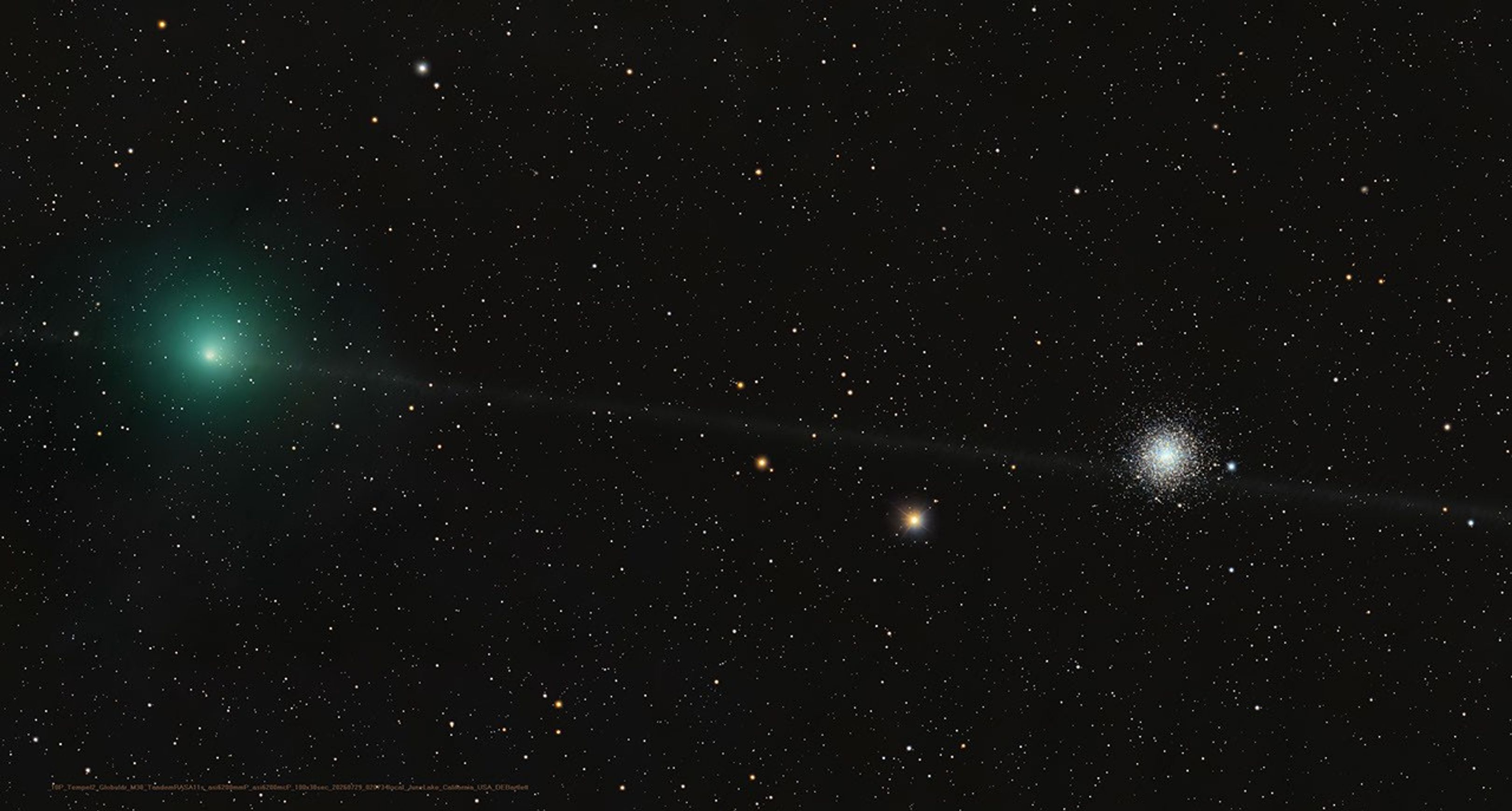
A Messier Moment for Tempel 2
Explanation: Which of these is not a comet? You guessed it – the one on the right is a globular star cluster. The diffuse greenish coma of periodic comet 10P/Tempel 2 is at left in the frame. In fact the globular star cluster is Messier 30, also known as M30, or the 30th entry in astronomer Charles Messier’s catalog of things which are not comets. The well-known 18th century astronomer kept a list of objects he observed, now his famous Messier Catalogue of Nebulae and Star Clusters, which did not move from night to night against the background stars and so were not the comets he was hunting for. So the famous comet hunter would get the correct answer too, even though his telescope would show both 10P/Tempel 2 and distant star cluster as similar looking faint and fuzzy objects in his field of view. Recorded on July 29, this modern telescopic image captures periodic comet Tempel 2 as it briefly swept close on the sky to M30. While the periodic comet’s faint, narrow, orbital dust trail seems to pierce the globular star cluster, Tempel 2 was a mere 3.5 light-minutes away. Messier 30 is some 28,000 light-years distant.
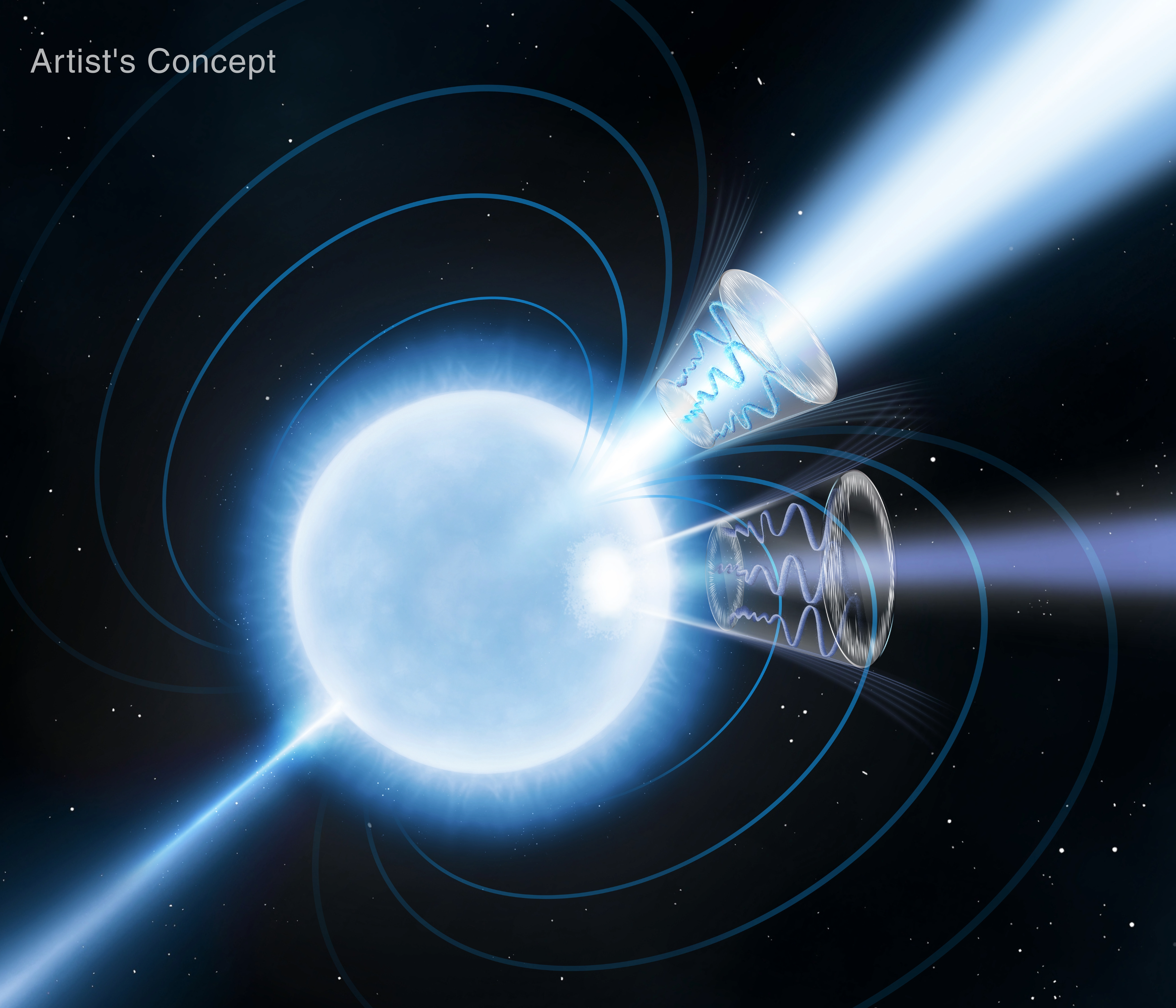
Magnetars are a special class of neutron stars with ultra-strong magnetic fields, the strongest of any object in the observable universe, around a trillion times stronger than the strongest permanent magnets ever built on Earth.
NASA’s Lunar Development and Test Facility Prepares Artemis Hardware for Moon
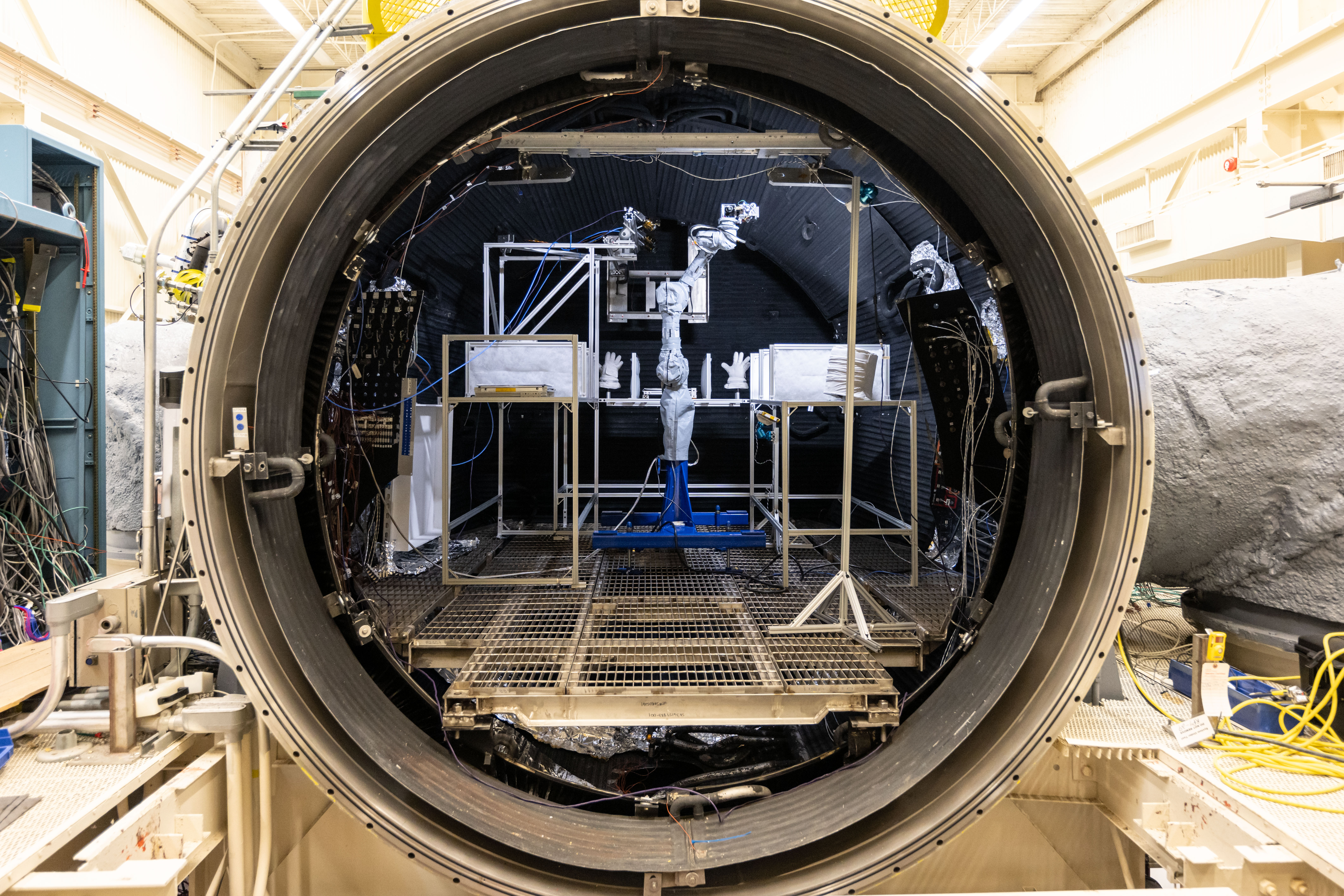
The Handheld Lunar Electrostatic Dust Mitigation tool is tested inside the Lunar Development and Test Facility at NASA’s Johnson Space Center in Houston.
Credits: NASA/Josh Valcarcel
Before astronauts return to the Moon’s surface through NASA’s Artemis program, the hardware they depend on must first prove it can survive the unforgiving lunar environment. At NASA’s Johnson Space Center in Houston, engineers at the Lunar Development and Test Facility are tackling one of exploration’s biggest challenges: Moon dust.
Unlike sand on Earth, lunar dust is sharp, abrasive, and clings to nearly everything. Without mitigation, lunar dust could damage equipment and spacesuits while posing health risks to astronauts. Understanding and mitigating the effects of lunar dust is essential as astronauts prepare to live and work on the surface of the Moon.
The Handheld Lunar Electrostatic Dust Mitigation tool is tested inside the Lunar Development and Test Facility at NASA’s Johnson Space Center in Houston.
NASA/Josh Valcarcel
Located within the Energy Systems Test Area and managed by NASA engineers, the Lunar Development and Test Facility supports the development and testing of hardware in simulated lunar conditions. Engineers evaluate systems and subsystems inside vacuum chambers using lunar regolith simulant to better understand how spacesuits, spacecraft components, and mechanisms with moving parts and joints will perform during future Artemis missions.
Lunar spacewalking tools undergo a dust mitigation test inside Johnson’s thermal vacuum chamber.
NASA/Bill Stafford
NASA Johnson’s Propulsion and Power Division developed specialized systems that make the facility’s lunar simulations possible. The facility includes a dust containment and preparation laboratory for ambient testing, a 3-foot cube vacuum chamber, and a 15-foot thermal vacuum chamber.
Inside the chamber, engineers test hardware under realistic lunar conditions using lunar regolith simulant. The chamber uses a closed-loop nitrogen system to recreate the harsh lunar environment.
“The facility helps develop and test technologies needed for long-duration lunar exploration,” said Mike Salinas, Propulsion and Power Division branch deputy chief. “Engineers are advancing techniques to extract resources from lunar regolith, which can be turned into oxygen for astronauts and liquid oxygen for rocket propellant.”
The spirit of exploration extends beyond the facility’s walls. Its exterior features a large-scale mural depicting astronauts exploring the lunar surface beneath a view of the cosmos. Completed in 2024 by artist Sebastian Boileau, the artwork celebrates the innovation, ingenuity, and discovery happening inside the building every day.
Artist Sebastien Boileau, left, and Margaret Braun pose in front of Johnson’s Lunar Development and Test Facility after the mural’s completion on Feb. 7, 2024.
NASA/Josh Valcarcel
Now, anyone can step inside the facility from anywhere. Explore NASA’s new 3D virtual tour of the Lunar Development and Test Facility to see where engineers are helping prepare the technologies that support this Golden Age of exploration and innovation.
Discover the cosmos! Each day a different image or photograph of our fascinating universe is featured, along with a brief explanation written by a professional astronomer.
Rubin’s COSMOS Field
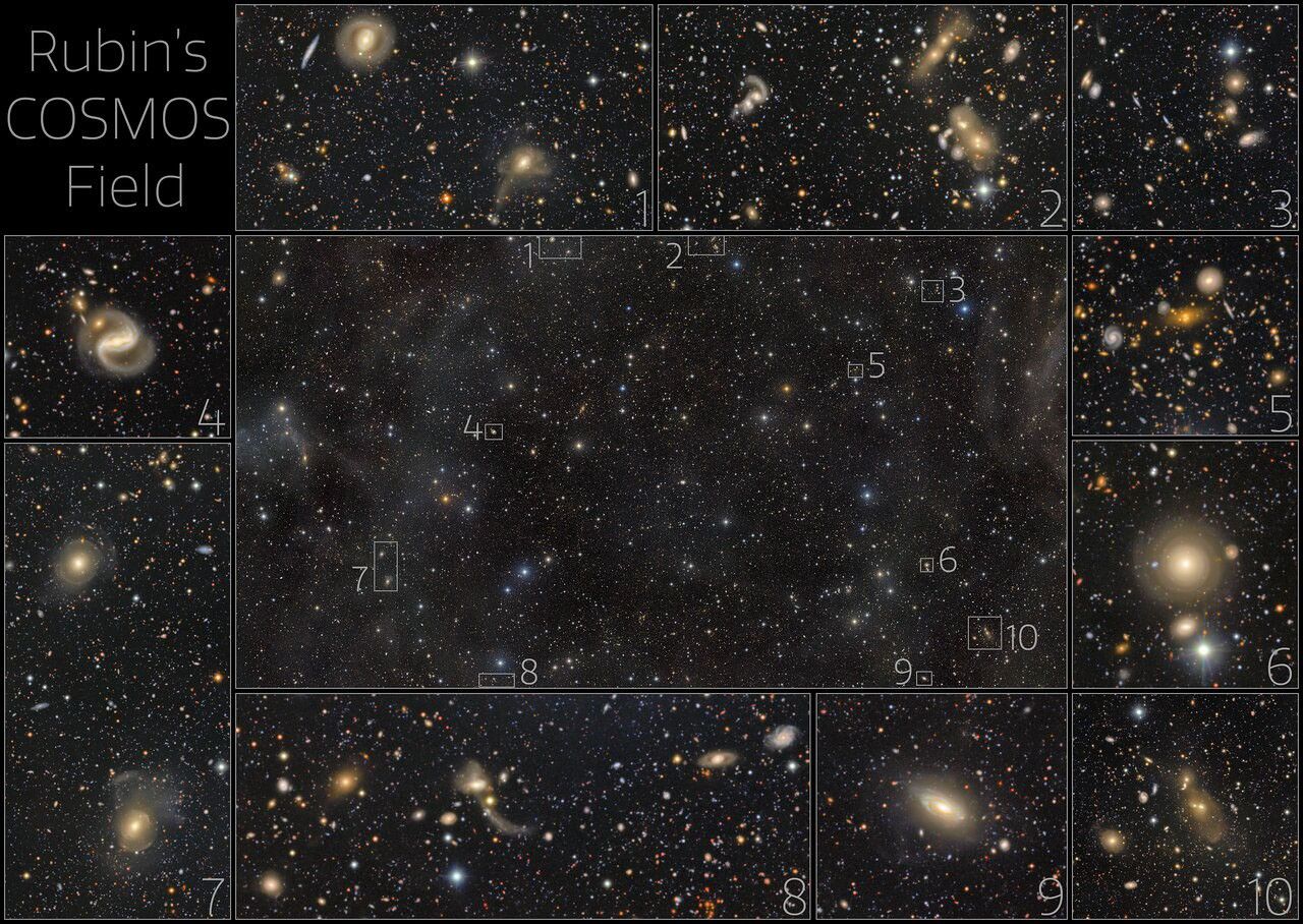
Explanation: There are more than half a million galaxies in the central panel of this image from the NSF-DOE Vera C. Rubin Observatory in Chile. This is the COSMOS field, a patch of sky several times larger than the full moon, first observed by Hubble. It has also been observed by Webb and other telescopes because it contains comparatively few bright stars from our own galaxy, offering a relatively unimpeded view of other galaxies outside the Milky Way. The outer panels, numbered 1-10, show zoomed-in views of the corresponding small regions highlighted in the central panel. The variety of galaxy shapes and sizes is astonishing. Some of them are so far away that their light has traveled for billions of years before reaching Earth. Rubin will come back every couple of days to the COSMOS field as part of its ten-year Legacy Survey of Space and Time. It will allow a dynamic view of the COSMOS field and how the sky changes over time.
Surface temperatures across Earth’s poles pulse with the seasons, as seen in this animation based on two years of data collected by NASA’s PREFIRE (Polar Radiant Energy in the Far-InfraRed Experiment) mission.
NASA/Chad Greene
At the top and bottom of the planet, the seasons arrive on a schedule all their own. Satellite data from a mission measuring infrared energy reveal just how differently—and how dramatically—surface temperatures swing across two full years at the poles.
In this animation, surface temperatures across the Arctic and Antarctic pulse between cold (dark blue) and milder to warm (lighter blue to red). Data for the animation come from NASA’s PREFIRE (Polar Radiant Energy in the Far-InfraRed Experiment) satellites. The mission’s twin CubeSats began collecting science data in July 2024 and have now captured two complete seasonal cycles at each pole.
Because the two poles sit in opposite hemispheres, their seasons occur at opposite times—and the swing between seasons differs, too. In the Arctic, cold, dark winters give way to summers warm enough to thaw vast stretches of tundra and sea ice. In Antarctica, Earth’s coldest continent, summer temperatures rarely climb above freezing before the bitter cold of winter returns.
Surface temperatures, and how they fluctuate, offer a window into Earth’s energy budget, the net flow of energy into and out of the Earth system. Sunlight absorbed by the surface is re-radiated as infrared heat, which bounces between Earth’s surface and atmosphere before escaping to space. The poles play an important role in this process. Atmospheric and ocean circulation carries excess heat absorbed in the tropics toward the poles, where it radiates away to space, helping regulate the planet’s temperature.
“By measuring invisible heat radiating from Earth’s coldest places, PREFIRE is helping scientists understand why the poles are changing so rapidly, and what those changes might mean for the rest of the planet,” said Chad Greene, a glaciologist at NASA’s Jet Propulsion Laboratory.
Scientists have long known that far-infrared radiation accounts for nearly 60 percent of the energy Earth loses to space, but that portion of the spectrum—invisible to human eyes—had never been comprehensively measured on a global scale. By directly tracking this invisible energy in near-real-time, the PREFIRE mission is helping scientists refine models and gain a better understanding of the Earth system.
“Weather systems, river flows, shipping routes, and ice sheet stability are all influenced by energy movement in a part of the spectrum that only PREFIRE can see,” said Tristan L’Ecuyer, an atmospheric scientist at the University of Wisconsin-Madison and principal investigator of the PREFIRE mission. “Now that the invisible has been made visible, we can begin to improve weather and climate predictions that industries, our national defense, and Arctic communities rely on.”
Maps courtesy of Chad Greene, NASA/JPL, using data from NASA’s PREFIRE mission. Story by Kathryn Hansen.
Educators & Teens Get Hands-On With TEMPO Data to Help Investigate Local Air Quality
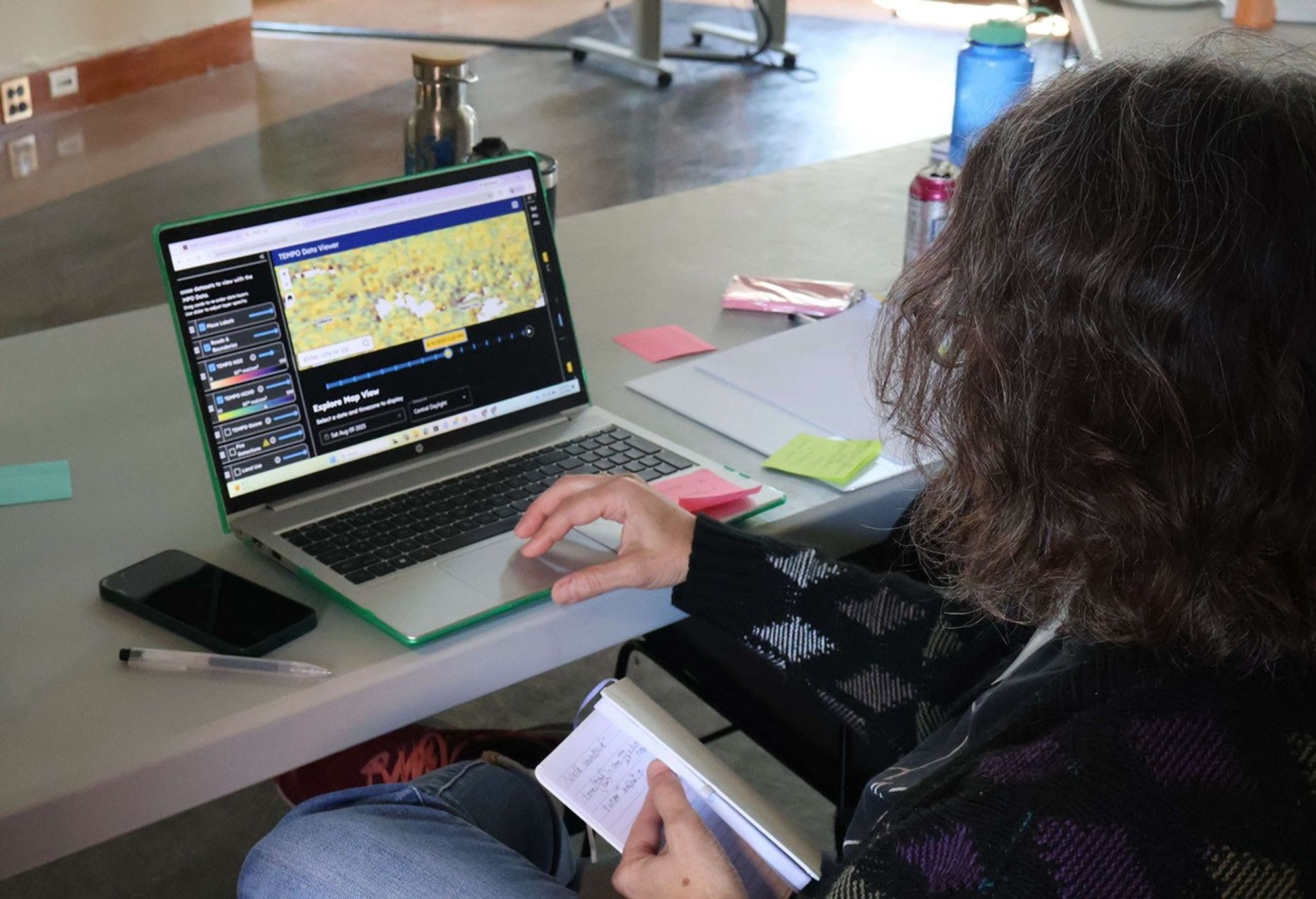
An educator explores NASA’s TEMPO mission data using the CosmicDS TEMPO-Lab viewer during a hands-on immersion session at the BEST AQI Leadership Institute.
Credit: Devika Elakara
The NASA Science Activation Program’s Cosmic Storytelling with NASA Data (CosmicDS) project, led by Harvard University in Cambridge, Massachusetts, works to bring authentic NASA data into the hands of educators and learners. From July 27–29, 2026, the CosmicDS team partnered with the Smithsonian Institution’s BEST AQI (Breathing Easier: Supporting Teen Air Quality Investigations) project to host a Leadership Institute at the Center for Astrophysics | Harvard & Smithsonian (CfA) in Cambridge, MA. The Institute brought together 13 formal and informal educators who serve as advisors to BEST AQI, an initiative that guides teens through their own air quality research to support actions that improve air quality in their communities.
On Day 1 of the Institute, the CosmicDS Science Principal Investigator Pat Udomprasert led a hands-on immersion session introducing educators to TEMPO-Lab, a free online tool built with NASA Science Activation Program funding. TEMPO-Lab lets learners explore and analyze near-real-time air quality measurements collected by NASA’s TEMPO (Tropospheric Emissions: Monitoring of Pollution) mission, which measures pollution across North America hourly during daylight hours. During Days 2 and 3 of the Institute, as educators worked together to co-develop BEST AQI curriculum and resources, they used TEMPO-Lab to build case studies covering a variety of real-world air quality scenarios, including wildfire smoke and emissions from rush-hour traffic, power plants, and agriculture. These case studies will give the teens in their programs a strong foundation for investigating air quality where they live and deciding what actions they might take in their own communities.
One moment made the workshop especially memorable. During a science briefing, TEMPO scientist Heesung Chong shared that a new beta-version ground-level ozone data product had recently become available. TEMPO-Lab’s flexible design made it possible for CosmicDS software developer and educator John Lewis to integrate the new data product into the tool overnight, letting workshop participants explore cutting-edge ozone data themselves the very next morning. It was a striking example of how CosmicDS’s data tools can match the pace of active NASA science, giving educators and their learners access to data almost as soon as scientists themselves do.
“The BEST AQI Leadership Institute reinforced the value of the TEMPO-Lab as a tool for empowering youth to investigate local air quality issues using authentic NASA data. Educators were excited not only by the scientific capabilities of the platform, but by its potential to help young people use evidence to make informed decisions and contribute to positive change in their communities.”
— Erika Wright, Education Specialist, Smithsonian Astrophysical Observatory (SAO), and BEST AQI Principal Investigator
Equipping educators with both the technical skills and the curriculum to bring NASA air quality data into their classrooms matters because it builds data literacy skills that teens can carry into any career, while also giving them the tools to investigate issues that affect their health and their own communities. Air quality is a subject teens can see, smell, and feel the effects of — and BEST AQI is designed to help them turn that lived experience into evidence-based understanding and, ultimately, action.
The CosmicDS team will continue supporting these efforts in the year ahead. The 13 educators who attended this Leadership Institute plan to share the BEST AQI toolkit and TEMPO-Lab with approximately 100 additional educators across their partner sites in South Dakota, Maryland, and New York, potentially extending this work to thousands of teen air quality researchers.
Cosmic DS is supported by NASA cooperative agreement award number 80NSSC21M0002 and is part of the NASA Science Activation Program portfolio, which connects learners with authentic NASA science experiences through partnerships with educators and community organizations.
NASA’s SkyFall Helicopters at Work (Artist’s Concept)
PIA26760
Credits: NASA/JPL-Caltech
Downloads
NASA’s SkyFall Helicopters at Work (Artist’s Concept)
JPEG (3.25 MB)
Description
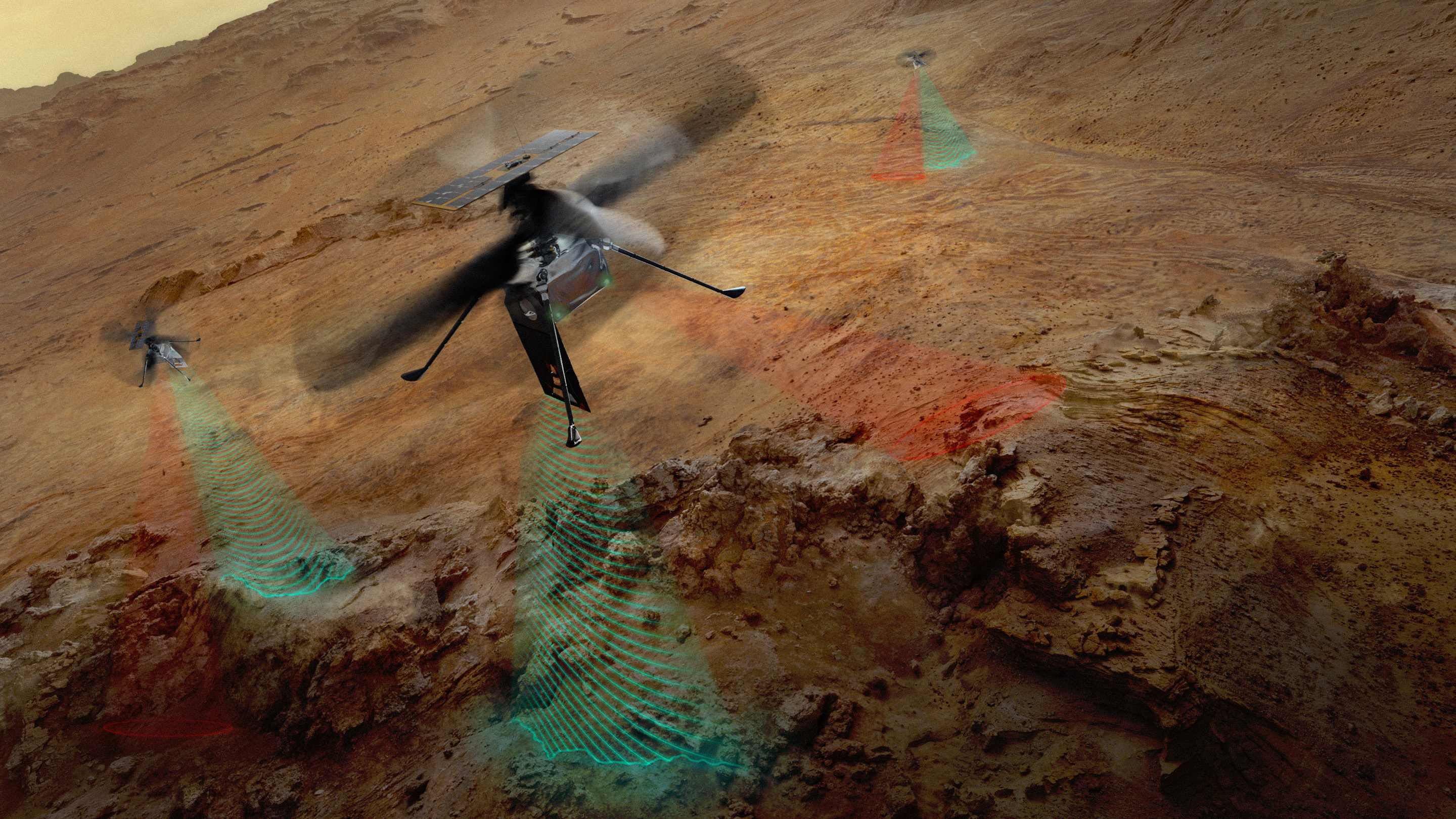
This artist’s concept depicts NASA’s three SkyFall Mars helicopters collecting data while flying over the surface of the Red Planet.
The green frequency waves emanating from the helicopters’ large antennas depict collection of subsurface radar data. The red beams depict collect near-infrared imagery data from regolith (crushed rock and dust) and other surface features.
Equipped with four instruments each, the three helicopters will follow in the footsteps of the agency’s Ingenuity Mars Helicopter, a technology demonstrator that flew 72 times over nearly three years, proving that powered, controlled flight is possible in the rarefied Martian atmosphere. It also demonstrated how an aerial perspective can generate valuabledata by helping NASA’s Perseverance Mars rover team plan time-saving routes and choose locations for science-gathering.
The SkyFall project, which will carry three Mars helicopters to the Red Planet in December 2028, is managed by NASA’s Jet Propulsion Laboratory. AeroVironment of Arlington, Virginia — which worked with JPL to design and build the history-making Ingenuity rotorcraft — will co-design and co-manufacture the SkyFall helicopters. Managed by Caltech for NASA, JPL manages the overall Mars Exploration Program on behalf of NASA’s Science Mission Directorate in Washington.
SkyFall ground-penetrating radar engineer Maya Román connects a coaxial cable to a test antenna in the Environmental Test Lab’s electromagnetic interference testing chamber at NASA’s Jet Propulsion Laboratory in Southern California.
The antenna was pointed up during test to minimize reflections and interferences with the antenna pattern during the measurement.
Equipped with four instruments each, the three SkyFall aircraft will follow in the footsteps of the agency’s Ingenuity Mars Helicopter, which flew 72 times over nearly three years, proving that powered, controlled flight is possible in the rarefied Martian atmosphere. It also demonstrated how an aerial perspective can generate valuable data by helping NASA’s Perseverance Mars rover team plan time-saving routes and choose locations for science-gathering.
As NASA sets its sights on long-term exploration of the Moon and Mars, the agency is increasing the cadence of its Artemis missions. Helping bring these plans to fruition is Tom Percy, manager of systems engineering and integration for NASA’s Human Landing System Program.
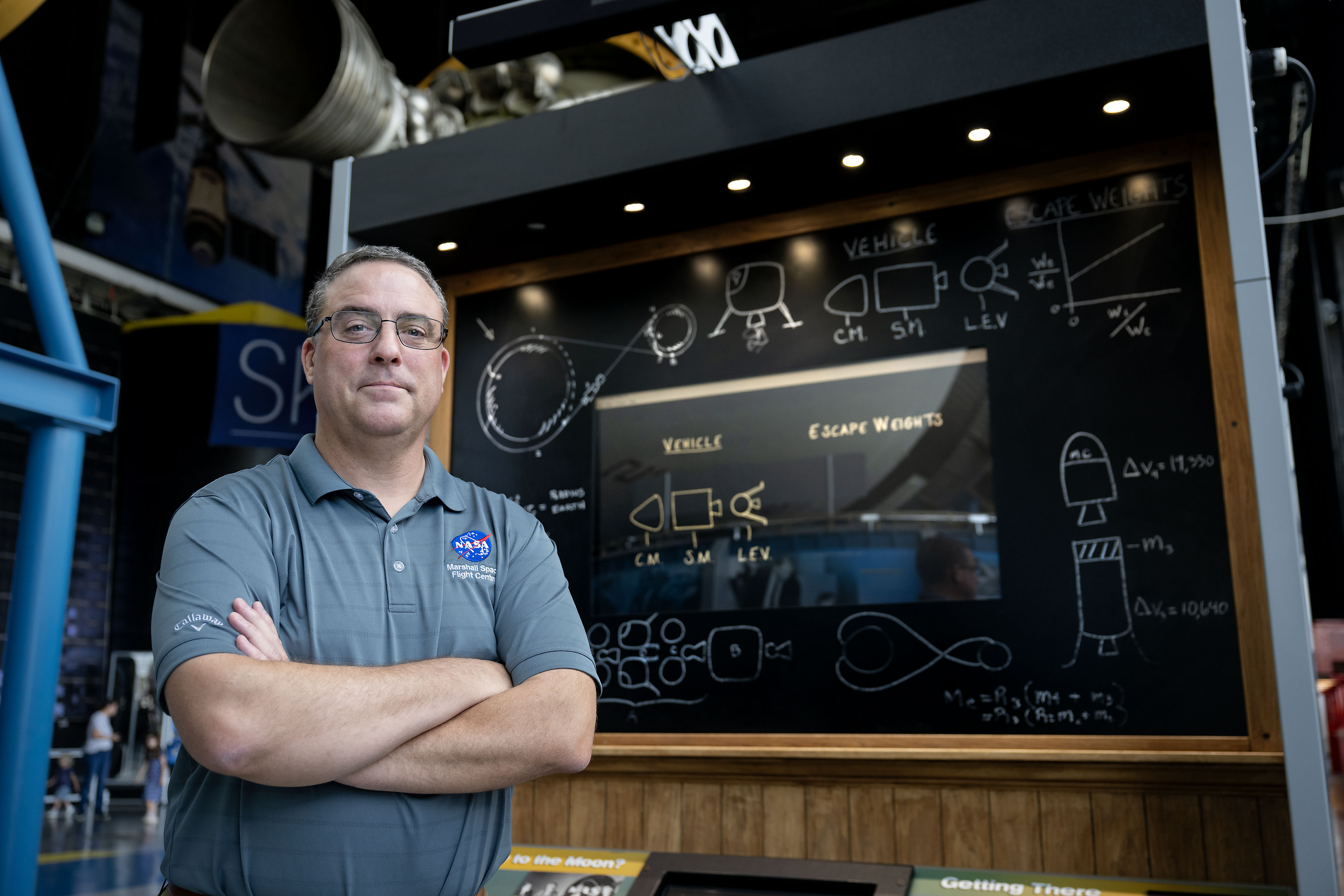
Tom Percy, manager of systems engineering and integration for NASA’s Human Landing Systems Program, stands in front of an Apollo Program lander exhibit at the U.S. Space and Rocket Center in Huntsville near NASA’s Marshall Space Flight Center.
NASA/Charles Beason
Percy serves as a focal point in working with providers SpaceX and Blue Origin to accelerate and streamline systems designs, manufacturing, testing, and certification. He ensures the crewed landers that SpaceX and Blue Origin are developing for Artemis are designed, built, tested, and will operate with other NASA exploration assets safely and effectively.
“You might say that all human landing system integration work lands on my desk. And with the rest of my talented, hard-working systems engineering and integration team, we’re working to make it all happen,” Percy said.
A native of North Easton, Massachusetts, Percy earned a bachelor’s degree in mechanical engineering from the Rochester Institute of Technology in Rochester, New York, where he first got hands-on experience working on designs that could be applied to NASA’s sustainable lunar architecture.
“As an undergrad, I served as president of the Rochester Institute of Technology’s chapter of the American Society of Mechanical Engineers. To get some real-world engineering experience, we decided to participate in the Great Moonbuggy Race,” Percy said. “Now called the Human Exploration Rover Challenge, the competition is held annually at NASA’s Marshall Space Flight Center in Huntsville, Alabama.
“At the time, I had never heard of Marshall Space Flight Center,” said Percy. “But our student team designed and built a rover and traveled to Huntsville for the race. That’s when I learned about some of the projects in Marshall’s diverse portfolio that the center works for NASA. And that’s when I began planning to make my way to NASA Marshall for my career.”
Percy chose to move south and earn a master’s degree in aerospace engineering from the Georgia Institute of Technology in Atlanta. His research in the advanced propulsion lab and courses in space systems design culminated in a spacecraft design course and the chance to work directly with engineers at Marshall.
Since landing at Marshall in 2003, Percy has been involved in evaluating transportation architecture options for human deep space exploration, including missions to land astronauts on the Moon and Mars. He also has expertise in space transportation, including advanced propulsion technology development; trajectory analysis; and spacecraft and mission concept development. Percy earned a doctorate in aerospace systems engineering from the University of Alabama in Huntsville.
The range of experience comes together in his current role as manager of human landing systems engineering and integration.
“The world watched the amazing success of Artemis II. NASA and our commercial providers are looking forward to flying again soon and executing increasingly complex Artemis missions,” Percy said.
Through the Artemis program, NASA will send astronauts on increasingly complex missions to explore more of the Moon for scientific discovery, economic benefits, establish an enduring human presence on the lunar surface, and to build on our foundation for the first crewed missions to Mars.

 Login