From sizzling bacon in the kitchen to wildfire smoke in the sky, cooking and pollution release microscopic particles that affect humans' health, the air they breathe, and even weather and climate. New research from Virginia Tech is poised to upend how scientists think about the structure of these tiny airborne droplets and what that means for predictions around air quality, pollution spread, and climate models.
France experienced its hottest spring on record, the country's weather service said Tuesday, after an exceptional early heat wave that also broke seasonal highs in England and Wales.
If your community was threatened by a wildfire, would you be able to quickly evacuate? A new study from UC Santa Barbara reveals that the number of roads out of a community may be one of the strongest predictors of wildfire fatalities, and that a surprisingly specific threshold separates high-risk communities from safer ones.
A new global study has found that people without access to clean drinking water are significantly more likely to experience food insecurity and food safety threats, underscoring the urgent need for coordinated global action to address these issues together.
Magnets for electric cars and wind turbines contain only a small amount of the rare earth metal dysprosium. Yet, this metal is responsible for a large share of the environmental impact and costs, according to research by environmental scientists Stellina Samuel, Robert Istrate and René Kleijn. The study is published in the journal Sustainable Production and Consumption.
Nearly 69 million people in the United States speak a language other than English at home, yet weather warnings have long been issued almost exclusively in English. A new study documents how the National Weather Service is using artificial intelligence to change that, developing a comprehensive translation program that delivers life-saving forecasts and alerts in Spanish, Chinese, Vietnamese, Samoan, French and other languages.
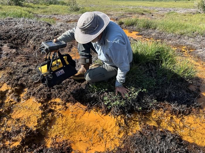
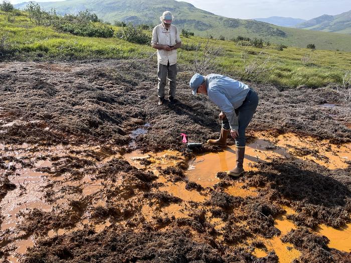
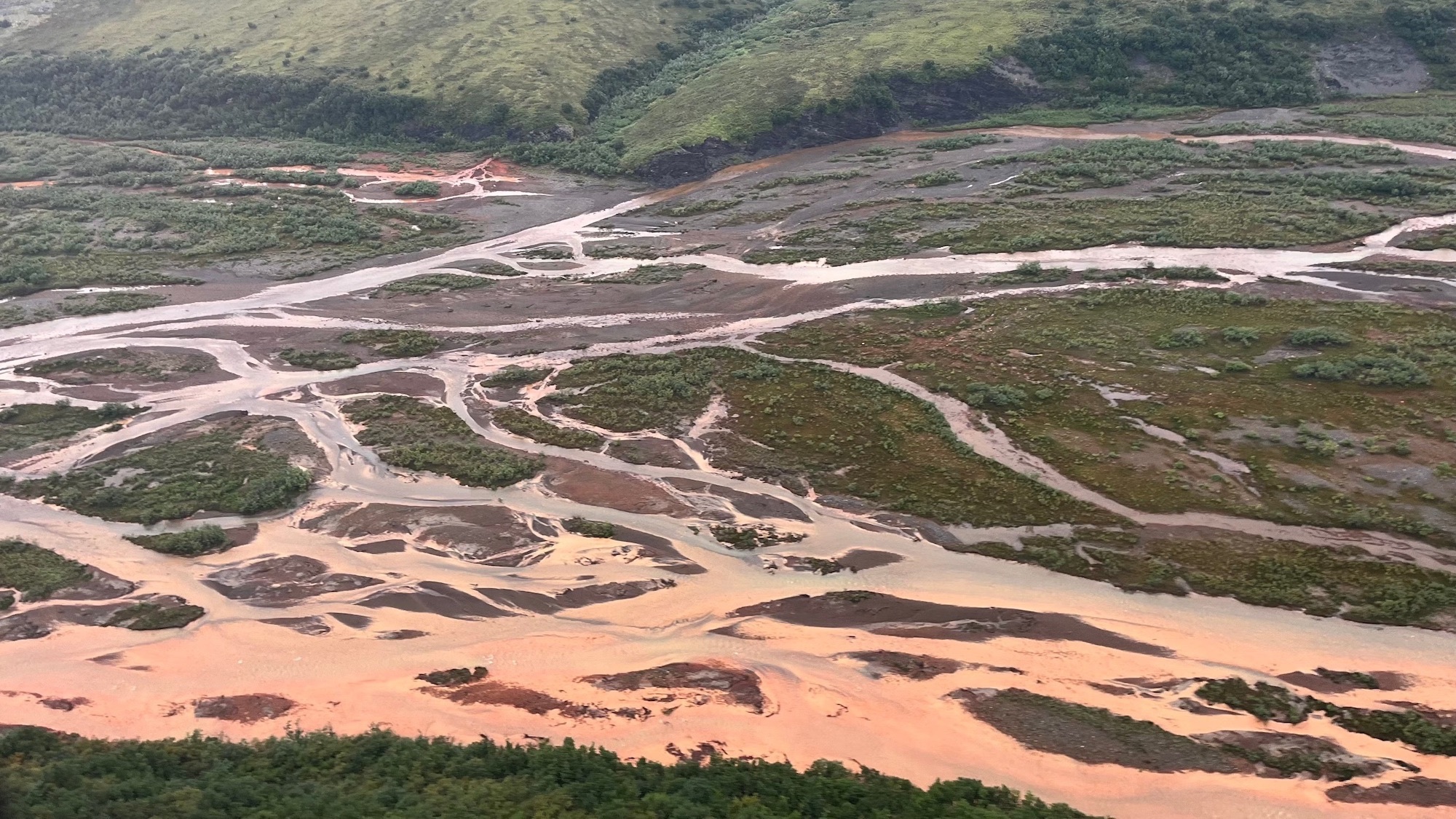
Alaska’s Arctic rivers have a big, orange problem. Previously clear rivers are turning a cloudy orange color due to iron particles, and it’s more than unsightly. The particles can suffocate fish and choke insects, threatening the food web and ecosystem as a whole.
Scientists have long pointed to previously frozen soil beginning to thaw as the potential culprit behind the contamination of rivers in northern Alaska’s remote Brooks Range, and a study recently published in the Communications Earth & Environment proves it. The research also shows two distinct ways that this thawing soil is rusting the rivers and can help scientists predict where the damage is likely to spread next.
“You’d think if any ecosystem could hide from the effects of warming and big human footprints, it’d be this one. But it’s not so,” Tim Lyons, a study co-author and biogeochemist at the University of California, Riverside, said in a statement. “There is no safe place.”
Researcher sampling rusty Alaskan river water. Image: Tim Lyons/UCR.
As the ice-filled permafrost begins to thaw due to climate change, it can turn into mud that can’t support the weight of the soil or vegetation above it. This can threaten human-built infrastructure such as homes, pipes, and roads. It can also expose iron particles from rocks that turn rivers orange, a process called rusting.
Rusting has severe ecological consequences. The fine iron particles can stay suspended in water for over 60 miles, smothering algae, disrupting insect populations, and clogging fish gills. These changes may already be affecting salmon in Alaska and Canada who rely on the gravel riverbeds for spawning and rely on algae as food during early life stages.
A top-down, fool’s gold problem
For this new study, the team looked at a wide regional view of the roughly 600-mile Brooks Range. They then zoomed in on a specific river system, followed by an even closer look at one creek. This top-down approach helped them to connect the bigger regional patterns to specific, on-the-ground processes.
“At middle, more heavily forested elevations, there isn’t much going on. But at the higher and lower elevations we could see distinctly different phenomena,” said Roman Dial, a study co-author math and biology professor emeritus at Alaska Pacific University.
At the higher elevations, the problem begins in the rocky ground containing pyrite, aka fool’s gold. Since the ground was frozen for many years, water and air didn’t affect the pyrite. Yet the rising temperatures have started to melt the ground, kicking off a process called acid rock drainage. The minerals and rocks are exposed to oxygen and water and degrade the water quality.
“When pyrite meets water, it comes apart. It breaks down into iron and sulfur, creating sulfuric acid as well as sulfate and other toxic metals,” said Lyons. “When the iron-rich water mixes with more oxygen, the iron turns into rust-like particles that color the water and stain the bottom sediments orange.”
It’s an entirely different story at the lower elevations. The landscape is covered with wetlands that are changing shape and expanding downward as the permafrost melts. In these more soggy places, the soils are low in oxygen. So instead of breathing in oxygen, the microbes in the water (mostly bacteria) are taking in iron.
“When we breathe, oxygen goes in and gets converted to the carbon dioxide that we exhale,” Dial said. “Similarly, microbes are consuming iron in the lowland soils and converting it into a water-soluble form that seeps into streams and results in rusting as it meets oxygenated surface water.”
Taken together, both acid rock drainage and microbes breathing in more iron help explain why orange waters are appearing across such large and remote regions across northern Alaska, closely tracking to areas where permafrost is thawing.
The direct link
The team also found a delayed effect that could help predict future contamination. During the summer, the active, top layer of soil thaws to its deepest point. It then refreezes before the winter. The iron released during one summer thaw can become trapped and then flushed into rivers the following year.
By studying long-term ground temperature data and stream chemistry, this lag can be used to anticipate increases in metal levels.
“That means we can use ground temperatures to help predict water quality in the future,” added study co-author and University of Alaska ecologist Paddy Sullivan. In 2019, Sullivan first noticed the dramatic river changes that looked “like sewage” during fieldwork in the region.
Since mines typically control the waters near them to minimize pollution, the team partnered with scientists at the Red Dog zinc mine in northwest Alaska. The scientists there have long-term temperature records from boreholes that are drilled deeply into the earth and from chemistry sampling in stream water. Linking the underground measurements with changes in the stream’s chemistry directly connected the thawing permafrost to the rusting rivers.
While this problem is difficult to contain and manage, predicting where the contamination may pop up next could help pinpoint and protect critical habitats. This forecasting is especially important for communities that depend on these waters and the fishing living there for food and cultural practices.
“There’s no fixing this once it starts,” Lyons said. “But we can give people downstream a heads up and work hard to protect the places that are still safe and less vulnerable to the rusting.”
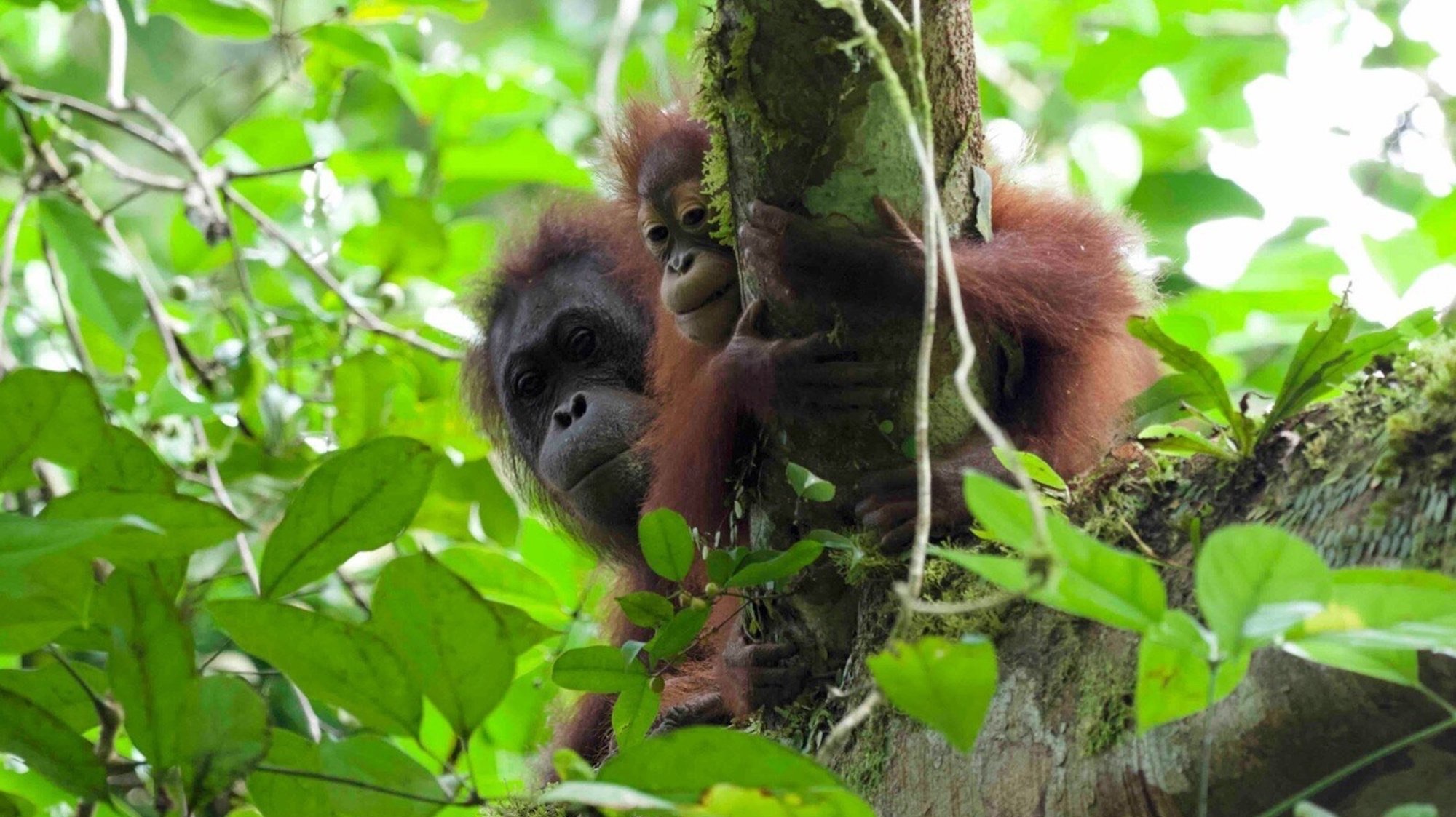
How do you determine how many months or years animal mothers nurse their babies? If you’re not in a rush and can observe this dynamic, you could supposedly stick around to see when the baby, mother, or both decide that they’re done. However, that could take years. A team of researchers investigating breastfeeding in orangutans recently opted for a different, perhaps surprising strategy—searching for particular proteins in poop.
In a preliminary study published in the journal Communications Biology, researchers searched for milk‑specific proteins in the feces of wild Bornean orangutans (Pongo pygmaeus) living in the Danum Valley Conservation Area, in the Malaysian part of the island of Borneo. These proteins prove that he or she is continuing to drink breast milk.The practice of recognizing particular proteins in feces is called fecal proteomics and it can help scientists better understand what animals are consuming.
“Orangutans have a slow life history with one of the longest interbirth intervals and the lowest reported infant mortality rates among primates or even mammals,” the team wrote in the study. “Breastfeeding is a key factor in their life history because it possibly promotes offspring health and increases maternal interbirth intervals.”
The team gathered fecal samples for over two and a half years, and found milk‑specific proteins in all the 20 samples from orangutans less than six and a half years old. This indicates that the young great apes were continuing to breastfeed until they were at least that age.
According to the team, these results are “consistent with the behavioral evidence as having one of the longest breastfeeding periods in mammals.”
What’s more, “milk intake was significantly correlated with higher levels of biological defense and probiotic bacterial proteins.”
In other words, the more milk a young orangutan drinks, the more probiotic intestinal bacteria it has and the sturdier its biological protections are. Such consistent and enduring breastfeeding probably helps the very high survival of orangutan babies and plays a role in their slow reproductive approach.
Unfortunately, Bornean orangutans are critically endangered, and the paper highlights why their populations don’t rebound quickly after a decrease. Safeguarding what’s left of their rainforest habitats is crucial.
There is an 80% chance of the warming El Niño phenomenon developing between June and August, increasing the risk of extreme weather events, the World Meteorological Organization said Tuesday.
A new study reveals that if left unchecked, unaccounted-for emissions of ozone-harming substances could delay the layer’s full recovery by almost a decade.
The renegotiation of the Ganga Water Sharing Treaty between India and Bangladesh is overlooking the most critical consequence of upstream river regulation: the catastrophic ecological and human toll in the Sundarbans delta.
En Colombia han ardido más de 500 incendios, incluso en sus delicados y únicos humedales del altiplano, uno de los ecosistemas de más rápida evolución de la Tierra
Más de 500 incendios han ardido en todo el país desde que comenzó 2024, consumiendo al menos 42.000 acres de bosques y pastizales y cubriendo la capital de Colombia, Bogotá, con una nube de humo contaminante.
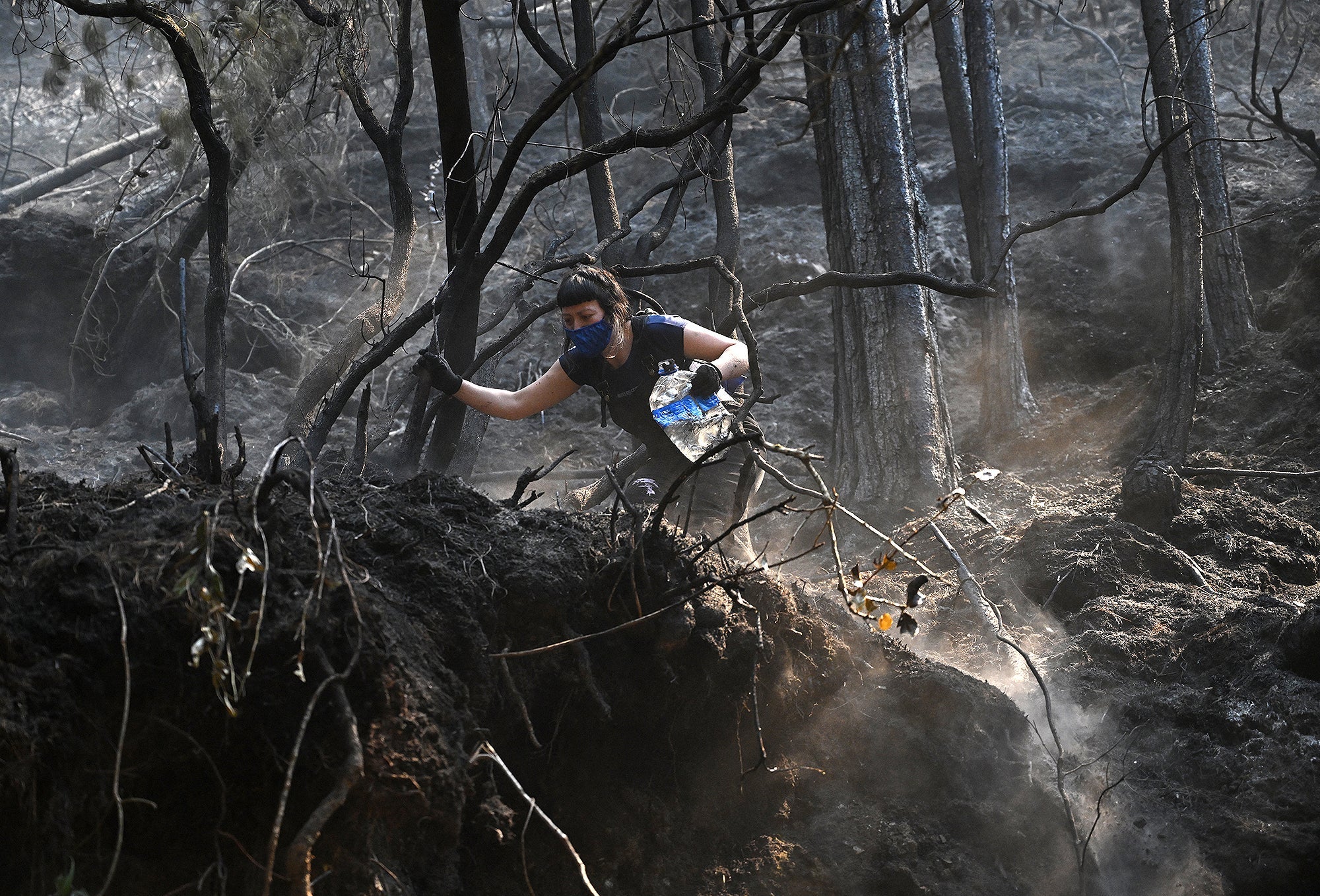
More than 500 fires have burned across Colombia, including in its delicate and unique highland wetlands, one of the fastest evolving ecosystems on Earth
A woman puts out a forest fire in Bogota on January 25, 2024. This Thursday, Colombia asked the member countries of the United Nations for help to extinguish around thirty forest fires that are ravaging several regions and drowning the capital, Bogota, in smoke.
Scania vient de démontrer une technologie capable de renvoyer l’énergie d’un camion électrique vers le réseau. Une avancée qui pourrait changer le rôle du transport lourd dans la transition énergétique.
47 years after the first of a series of mystery quakes shook Utah area residents, scientists have determined that these Earth-shaking events originate deep in the mantle rather than in the crust, where typical earthquakes originate.
Although the research team behind the published study outlining their mystery quake origin theory suggests a potential cause of these continental mantle earthquakes (CMEs), they said that there remain inherent challenges in studying these transient events, which occur in isolation without foreshocks or aftershocks, helping explain the decades-long mystery surrounding them.
“It’s sort of a mystery in terms of fundamental physics,” said the study’s leader, geology professor Keith Koper, “How in the world can these things happen?”
How a 1979 Mystery Quake Shook up Science for Decades
According to a statement announcing the new mystery quake findings, the enigma began on February 24th, 1979, when the University of Utah’s seismographic instruments detected an earthquake beneath the town of Randolph, near the Montana-Wyoming border. Although the relatively sophisticated instruments indicated it was a respectable 3.8 on the Richter scale, there was a surprising lack of public reports of shaking and rumbling that typically accompany such events.
When the young researcher decided to try to pinpoint the origin of the mystery quake that appeared suddenly without a foreshock, civilian reports, or a local fault line, his calculations didn’t make sense. According to Zandt, his data revealed that the mystery quake had originated 90 kilometers (about 56 miles) beneath the surface.
Because earthquakes originating below the so-called ‘Moho’ (Mohorovičić) region separating the Earth’s upper crust and lower mantle were considered impossible, the researcher was initially perplexed at the stubbornly consistent data. Still, he noted, the depth would help explain why people hadn’t felt the event, despite its relatively robust energy signature.
After some further analysis, Zandt, who has enjoyed a long career on the University of Arizona’s geology faculty since the initial mystery quakes investigation that he performed as a postdoctoral candidate and came out of retirement to co-author this new study, said the results “convinced me of the reality of the deep depth.” However, he added, “It was hard to convince others of the highly anomalous mantle earthquake occurring in a region where none should exist.”
New Analysis Finds Eight Additional CME’s and a Possible Cause
After submitting an abstract about the mystery quake for the journal Earthquake Notes, the young researcher’s findings of a mantle-originating event remained largely unnoticed. Then, in 2025, a new generation of university geologists took a fresh look at the data. According to the team’s published study, this included reexamining the waveform data from the original mystery quake and from eight other events that had occurred since then in the same general region.
After a thorough analysis and some input from Zandt, Professor Koper’s team confirmed that all nine events originated below the crust, resulting in the creation of the new CME category. Before the team published their findings, another CME was detected on September 10th, 2025. Measured at a magnitude of 4.1, the event originated approximately 68 kilometers beneath the surface, or over 20 km below the Moho line.
Above: A map of the Wyoming Craton region, where yellow stars are continental mantle earthquakes (CMEs) from 1979 to 2023. The orange stars are six recently identified CMEs that occurred between 2007 and 2010. The white stars are four suspected CMEs located by the U of U Seismograph Stations in 2025, and the red star is the location of the 2025 Maeser earthquake. The black thick line indicates the approximate lithospheric keel boundary of the Wyoming Craton (Image Credit: University of Utah Seismograph Stations).
According to Koper, the ‘archetypical continental mantle event’ was an example of an earthquake “nucleating in very unusual conditions.”
“The high temperature, the high pressure, and almost all the material at that depth is going to flow,” the professor explained, adding that the stretched deep Earth material is more like “taffy on long time scales, millions of years.”
“Nevertheless, you can still see it in rocks that have made their way back up to the surface; you can see how they were stretched,” he added.
‘Little Icebergs’ of Earth’s Lithosphere Direct the Mantle’s Flow, Like a Ship’s Rudder
Although the University of Utah team is confident in their identification of a new type of earthquake that originates beneath the crust in the mantle, they note that the newly identified CME’s still present a few mysteries. For example, the nine events characterized in their study occurred without any foreshocks or aftershocks. Koper said that another point that makes the study’s findings “a big deal” is that researchers have no idea how big a CME can be.
“With crustal earthquakes, we can measure what we think their maximum size is going to be,” the professor explained. “We measure the faults that we can map out near the surface. We can measure the length of a fault segment, and that clues us into how big it can be, which helps us estimate seismic hazard.”
More research will be needed to further understand the mystery quakes that randomly shake the relatively isolated region, but the study authors said they already have a working theory to explain these little-understood, transient events.
Resting within the Earth’s mantle are ancient blocks of the planet’s lithosphere, structures that the team compared to icebergs. According to the team’s theory, the area where the quakes are occurring has a geological composition and history that make it susceptible to the events leading up to a CME.
“On the scale of millions of years, the mantle is hitting the craton and then flowing around it,” Koper explained. “It’s that interaction where that mantle flow is being diverted around this hard cratonic root that’s causing the increased strain rate, the increased deformation, and it’s also creating extra stresses.”
“We think it’s that interaction between the keel of the iceberg and the medium around it that’s leading to these earthquakes,” the professor added.
Christopher Plain is a Science Fiction and Fantasy novelist and Head Science Writer at The Debrief. Follow and connect with him on X, learn about his books at plainfiction.com, or email him directly at christopher@thedebrief.org.
A major biological surprise has emerged from the heart of the mysterious Himalayas, according to scientists who made the unexpected discovery.
The vast mountain system in southern Asia is renowned for more than just its height—it is also one of our planet’s most under-explored regions in terms of its biological diversity. Currently, scientists estimate that there may be as many as several thousand unknown species awaiting discovery, with an average of more than 30 being discovered each year.
However, a remarkable recent discovery by scientists has revealed not one, but five different previously unknown Himalayan species—all of which were hiding in plain sight.
One of the most venomous snakes known to the region, the Himalayan pit viper, has now been revealed to be an entire species group, rather than just a single species previously recognized in two varieties.
The addition of three previously unknown species to the group now reveals a major biological surprise that has remained unknown to herpetologists—scientists who specialize in the study of snakes—for more than 160 years.
Five Times the Venomous Viper
Although the Himalayan mountains are probably the last place one would expect one of Asia’s most venomous snakes to reside, the Himalayan pit viper has been known to scientists since 1864. Since its discovery, scientists had long assumed it was a single species of snake that was fairly ubiquitous throughout the mountainous region.
Gloydius hindukushensis from northwestern Pakistan, also known as the Himalayan pit viper (Image Credit: Dr. Daniel Jablonski and Dr. Frank Tillack),
The surprise discovery that this species actually represents five distinct varieties of snake, revealed in a recent study that appeared in the open-access journal ZooKeys, upends that presumption.
The study relied on skeletal studies of existing specimens, supplemented by modern genetic analysis. These combined approaches, along with a fresh analysis of the physical traits of the venomous Himalayan reptiles in their natural environment, now reveal a much deeper and more distinctive evolutionary story about these dangerous Asian reptiles.
Hidden in Plain Sight
The recent findings now confirm three species that are entirely new to science, which primarily reside in portions of the mountain range in Pakistan and Nepal, each possessing slightly different skeletal and physical features.
Daniel Jablonski, a researcher with Comenius University Bratislava and an expert who has been studying species in this region for years, says it was no surprise that new species would have been found in the Himalayas.
“These mountain systems still harbor overlooked vertebrate diversity and hold important clues to the biogeography of Asia,” Jablonski said in a statement. What was surprising, however, was that three of these species had been hiding in plain sight, remaining misidentified as known varieties of Himalayan pit vipers.
“By combining modern field sampling with data from historical museum specimens, we uncovered evolutionary lineages that had remained hidden for more than a century after the original description of the Himalayan pit viper,” Jablonski adds.
Museum Discoveries
Based on specimens already being kept in museums—some of them more than a century old—Jablonski and his colleagues were able to reveal the deeper genetic diversity of these snakes, thanks to reexaminations that included the original type specimen of the species collected in the 19th century.
Sylvia Hofmann, a researcher with the Museum Koenig as part of the Leibniz Institute for the Analysis of Biodiversity Change, says that discoveries that significantly advance our knowledge of the natural world often begin with specimens that already exist in museums.
“Museum specimens are not just records of the past. They are active research tools and essential infrastructure for future science,” she says.
Hofman has spent the past two decades working in the Himalayas and the Tibetan Plateau, and is well aware of the kinds of discoveries this rugged part of the world features.
“Some of the key evidence had been sitting in museum collections for more than a hundred years. We just didn’t have the tools to recognize it,” Hofman said in a recent statement. “As analytical methods continue to improve, the scientific value of these collections will only grow and reveal biodiversity we didn’t even know was there.”
More Surprises Could Await
According to the research team behind the discovery, many more discoveries await scientists who are willing to go seeking the evidence.
“Pakistan’s high mountains are still full of biological surprises,” Rafaqat Masroor, a leading herpetologist with the Pakistan Museum of Natural History, said in a statement.
“This finding highlights how little we still know about a region long shaped by socio-political instability,” Masroor added.
Fundamentally, the discovery is significant not just in terms of expanding our knowledge of the natural world, but also because it has implications for conservation efforts in the region.
“Each of the newly recognized species seems to occupy a relatively restricted range in fragile mountain environments, highlighting new ecological and evolutionary questions,” Jablonski said.
The team’s paper, “Integrative taxonomy reveals previously undescribed diversity within the Gloydius himalayanus complex (Squamata, Viperidae, Crotalinae) from the Himalaya and Hindu Kush,” appeared in the journal ZooKeys.
Micah Hanks is the Editor-in-Chief and Co-Founder of The Debrief. A longtime reporter on science, defense, and technology with a focus on space and astronomy, he can be reached atmicah@thedebrief.org. Follow him on X @MicahHanks, and at micahhanks.com.
Researchers say that a discovery in remote northern Australia has revealed that a species thought to have been driven to extinction more than half a century ago has been rediscovered in the wild.
The discovery was made possible by a chance photograph uploaded to the citizen science platform iNaturalist, which came to the attention of researchers.
Now, scientists have confirmed that Ptilotus senarius, a delicate shrub that grows in some of the outback’s most sparsely populated regions and possesses a distinctive purple-pink flower, has been rediscovered in rugged terrain near the Gulf of Carpentaria in Queensland.
The species hasn’t been documented by naturalists in the wild since 1967 and was long thought to have gone extinct.
An Australian Shrub Springs Back from Extinction
The remarkable discovery initially surfaced when Aaron Bean, a professional horticulturalist, noticed the plant while working as part of a bird banding operation in a rugged portion of Australia’s northern outback. Intrigued by the colorful flower, Bean took photographs, which he later uploaded to iNaturalist, a popular website and app that allows users around the world to map and share observations of biodiversity.
Sometime later, Bean’s images on the platform eventually came to the attention of Anthony Bean, a botanist at the Queensland Herbarium who, ironically, shares the last name of the horticulturalist who made the initial discovery.
Ptilotus senarius, seen growing in one of northern Australia’s most remote regions (Image Credit: Aaron Bean/inaturalist.org/observations/288434421).
Their common name was perhaps only one of the many serendipitous circumstances related to the discovery, since the original images finding their way through millions of observations shared on the platform and coming to the attention of a Queensland Herbarium botanist was remarkable enough—add to that the fact that, in another surprising twist, Anthony Bean had formally described Ptilotus senarius himself roughly a decade earlier.
“It was very serendipitous,” said Thomas Mesaglio of the UNSW School of Biological, Earth and Environmental Sciences, who penned a recent paper documenting the discovery that appeared in the Australian Journal of Botany.
“Aaron Bean is an avid iNaturalist user who opportunistically took some photos of a few plants that were interesting on the property,” Mesaglio noted. Following the imagery that Bean obtained and its coming to the attention of the broader botanical community, researchers were dispatched to the property where the photos were captured, and, with the assistance of the landowners, the collection and confirmation of a specimen proved beyond any doubt that Ptilotus senarius survives.
A Breakthrough for Citizen Science
The rediscovery of Ptilotus senarius is not only a remarkable event for conservation efforts; it also highlights the growing importance of citizen science in biodiversity research.
With the availability of platforms like iNaturalist, members of the public with little more than a keen interest in the natural world can contribute valuable observations that often help advance science in meaningful ways.
In cases like this one, it can even lead to rediscoveries of species thought extinct or, in some instances, to the identification of entirely new species.
Thanks to such discoveries, several programs, including New South Wales’ Land Libraries initiative, have begun ramping up efforts to encourage landowners to document species on their properties and contribute observations to citizen science databases.
Among the most important pieces of information that citizen scientists can contribute are multiple photographs from various angles whenever possible. With regard to plants, being able to identify bark, stems, leaves, and other key features, as well as the surrounding habitat, can greatly help with accurate species identification.
Additional information that can assist with such identifications includes photos of soil conditions, nearby vegetation, scents the vegetation may produce, and information about local pollinators.
“The more information you can provide and the more context you can provide, the more potential uses that record will have in the future,” Mesaglio said.
Micah Hanks is the Editor-in-Chief and Co-Founder of The Debrief. A longtime reporter on science, defense, and technology with a focus on space and astronomy, he can be reached atmicah@thedebrief.org. Follow him on X @MicahHanks, and at micahhanks.com.