Login

Antarctica just experienced minus 119 F, Earth's coldest temperature since 2012 — here's why
While millions around the world grappled with extreme heat this month, a research station in Antarctica recorded Earth's coldest temperature since 2012.
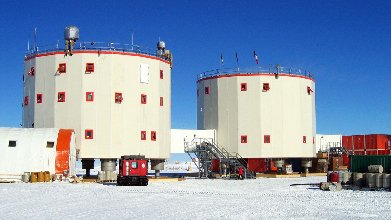
The high-altitude research station, named Concordia, logged a low of minus 119.4 degrees Fahrenheit (minus 84.1 degrees Celsius) on July 18, according to data from the station.
Concordia is located in the interior of the Antarctic continent, which is currently in the dead of winter with no sunlight. Temperatures at the station regularly fall below minus 112 F (minus 80 C) this time of year — so the new reading isn't unprecedented, but it's still significant.
"Even here, where extreme cold is expected, temperatures below minus 84 C are remarkable and highlight how variable Antarctic weather can still be," Gabriele Carugati, the station leader at Concordia for Italy's National Antarctic Research Program (PNRA), told Live Science over a video call from the station.
The French Polar Institute Paul-Émile Victor, which runs Concordia with the PNRA, sent Live Science raw data from July 18, which showed the temperature dropping to minus 84.1 C twice, at 6:25 a.m. and 6:34 a.m. local time.
The extreme chill at Concordia stands in sharp contrast to the sweltering heat that many countries are currently experiencing. North America and Europe have been battling heat waves this summer, with Western Europe recording the hottest June on record. Meanwhile, wildfires are raging in Canada, the U.S., France, Spain and other countries.
Globally, average temperatures are going up as humans pump more heat-trapping greenhouse gases into the atmosphere. However, Earth's weather systems are complex, and climate change doesn't mean that everywhere gets hotter all of the time.
"Climate change describes the long-term global trends, while individual weather events can still [bring] exceptional cold," Carugati said. "Antarctica is influenced by complex atmospheric processes, so an extreme low temperature at one location does not contradict the broader picture of global warming."
"Astronauts of ice"
Concordia is considered the most remote and extreme research station in the world. Built on top of a 10,800-foot-thick (3,300 meters) ice cap, the station is used for a variety of purposes, including seismic observations, astronomy and the modeling of Earth's past climates, according to the French Polar Institute Paul-Émile Victor.
"Concordia is a special place because it sits at over 3,200 meters [10,500 feet] above sea level on the Antarctic Plateau, and more than 1,000 kilometers [600 miles] from the coast," Carugati said. "During winter, there is no sunlight for months, the atmosphere is extremely dry and stable, and under clear skies, heat continuously escapes to space because there are no clouds, allowing temperatures to fall to extraordinary levels."
Concordia's environment is so harsh and isolated that the station is also used to improve our understanding of the physical, mental and social challenges astronauts experience in space. Carugati noted that the only person at the station who is not researching the environment is a European Space Agency biomedical doctor, who is studying the researchers who work there, nicknamed "astronauts of ice."
Planes can't fly to Concordia once winter sets in, and it's around 370 miles (600 kilometers) from the nearest research station. That technically makes crews more isolated than astronauts on the International Space Station, which orbits about 250 miles (400 km) above Earth, according to the European Space Agency.
What is the coldest temperature ever recorded?
The coldest temperature ever recorded at Concordia was minus 120.5 F (minus 84.7 C), logged in the winter of 2010, according to the Italian Antarctic Meteo-Climatological Observatory. However, another high-altitude research station in East Antarctica has the all-time record for the coldest temperature ever recorded on Earth. Russia's Vostok weather station, the nearest station to Concordia, recorded a temp of minus 128.6 F (minus 89.2 C) in July 1983, according to the World Meteorological Organization.
Satellite data suggests that temperatures can drop as low as minus 144 F (98 C) in East Antarctica, according to a 2018 study published in the journal Geophysical Research Letters. However, even though Antarctica is the coldest and driest continent, it's not immune to global warming.
Major glaciers and the ice sheet they support are at risk in West Antarctica, with the Antarctic Peninsula — which extends out of the western side of the continent — experiencing the most rapid warming. A study published in February in the journal Frontiers in Environmental Science found that decisions made on greenhouse gas emissions today will determine how much the peninsula will change in the coming centuries, with sea ice, ice shelves and glaciers, along with the penguins that live on them, at risk of disappearing.
Concordia sits on the largest ice sheet on Earth. This sheet in East Antarctica is more stable than the smaller sheet of West Antarctica, but it is still vulnerable to rising temperatures. An unprecedented Antarctic winter heat wave in March 2024 saw temperatures near Concordia rise to a record high of 15.1 F (minus 9.4 C) — about 32 F (18 C) warmer than the previous March maximum. This East Antarctic heat wave was amplified by global warming, according to a study published in April in the journal npj Climate and Atmospheric Science.
- A Texas-size chunk of winter sea ice is missing from Antarctica — and it's probably not coming back
- Hundreds of hidden earthquakes discovered beneath Antarctica — and they're happening in a very odd location
- The 'Doomsday Glacier' is poised to lose its ice shelf this year. An Antarctic researcher explains what that means for global sea levels.
Earth recently entered an El Niño, the warm phase of a multiyear natural climate pattern, which could bring unprecedented temperature extremes to an already-warming world. Carbon Brief, a U.K. based outlet that reports on climate news and policy, has predicted that 2026 is likely to be the second-warmest year on record, behind 2024, with the intensifying El Niño increasing the likelihood that 2027 will be the warmest year ever recorded.
For now, at Concordia, the researchers are continuing their work in the blistering cold of Antarctica's winter. Carugati noted that the latest extreme-temperature data will inform forecasts and long-term climate monitoring.
"Extreme observations like this help scientists better understand atmospheric processes and improve the climate models," he said.