❌

Reading view

Curiosity Blog, Sols 4927–4933: Let’s Drive to That Smooth Area

4 min read

Curiosity Blog, Sols 4927–4933: Let’s Drive to That Smooth Area

A black-and-white landscape photograph of the Martian surface taken by the Curiosity rover. The ground features a heavily textured, polygonal cracked pattern, with light-colored material forming raised veins or ridges along many of the cracks. Several dark, flat rock slabs and smaller loose rocks are scattered across the foreground and middle ground. On the right side of the image, the textured tread marks of the rover's wheels are clearly visible pressed into the soil, curving slightly as they trail off into the distance.
NASA’s Mars rover Curiosity acquired this image showing a breathtaking diversity of polygons, veins, and other textural features waiting for investigation by the Mars Science Laboratory team. Curiosity captured the image using its Left Navigation Camera on June 17, 2026 – Sol 4928, or Martian day 4,928 of the Mars Science Laboratory mission – at 17:47:52 UTC.
NASA/JPL-Caltech

By Susanne P. Schwenzer, Professor of Planetary Mineralogy at The Open University, UK

Earth planning date: Thursday, June 18, 2026

In the area Curiosity is currently exploring, the science team has mapped several areas with different-looking surface texture on the orbital images. If you wanted to have a look yourself at what there is to see, check the “Where is Curiosity?” map. You’ll discover different shades of orange and beige as well as more rough and more smooth-looking textures. This is what the geomorphologists in our team use to map the areas for exploration by the rover. Of course, we then supplement this all with ground-based images, including bespoke “drive direction imaging,” which is taken after each drive by the Mast Camera. Drive planning is done using a combination of all this information. So there shouldn’t be any surprises, right?

On Monday the team planned three sols in preparation for a Thursday planning to account for the U.S. federal holiday weekend. The workspace turned out to be a little spiky, so we could not find an area we could DRT. APXS still found one good bedrock target, “Rio Baker,” which also had MAHLI documentation. In addition, ChemCam investigated “Rica Aventura,” a textured bedrock, and “Tabebuia,” a darker-looking individual block, using its LIBS and conducted a passive spectral observation on a second dark float block called “Lago Ranco.” Of course, the team also wanted to look into the distance with ChemCam remote imaging, extending our investigation of the Cordillera base outcrop.

Imaging is always high on the list. In Monday’s plan Mastcam is looking into the modern dunes with the “Tacaza” mosaic, and with more mosaics looking forward to the future parking areas, some of which looked really smooth from that vantage point. We also continue our environmental and atmospheric observations looking for dust devils, the opacity of the atmosphere, and monitoring pressure and temperature. After all this, the rover drove about 35 meters (about 115 feet) to an area that looked really smooth in all images we had available at that point. So we were hoping for a good spot to deploy the DRT, but didn’t think we could be in for a surprise.

The drive ended exactly as planned, spot-on in the middle of that — from a distance — smooth-looking area. But when we opened the post-drive images on Thursday morning, we were all reacting with a lot of surprise. From up close, the parking spot looks anything but smooth. You can see the surprise in the title image of this blog. There are polygons, veins, lamination, and probably more, once we inspect the higher-resolution images taken today. “Higher-resolution” is the key for why we were in for such a surprise! The features are quite small, a few centimeters across, and therefore we could not see them in the orbital images or from a distance in our navigation and mast camera images. The camera resolution from a distance just isn’t enough to see them. But up close, the terrain revealed all its beauty! And I am sure there will be more in the even higher resolution of today’s MAHLI and ChemCam RMI imager images!

So, what did we plan after we caught our breath on Thursday? First, you guessed it, images, images, and more images. Mastcam takes a full panorama with its “left eye” and adds a range of closer-up mosaics with its higher-resolution “right eye.” In addition there is a ChemCam Remote Micro Imager image to document structures further afield at high resolution. ChemCam is investigating three targets using LIBS: “Rio Chimore” is a lighter-toned band; you can see some of those in the cover image of this blog, too. The other two LIBS targets are “Rio de Lava,” a vein target, and “Rio de Salta,” one of the polygons. APXS is also looking at the bedrock and the ridges, at the targets “Pampa Grande” and “Iquique Ridge.” MAHLI is having the above-mentioned close “hand lens” look. Let’s see what we will discover when we get those images.

Finally, Curiosity drove up the hill along very smooth-looking terrain that is just littered with tiny polygons. Let’s see if we are in for another surprise reverberating around all our offices — and across two continents, as I had the good fortune to be among the first ones, here in England (Or maybe it was our French ChemCam colleagues, who are in a time zone one hour ahead of me?). Whichever it is, this terrain has a lot to say about the geologic history of Mars!
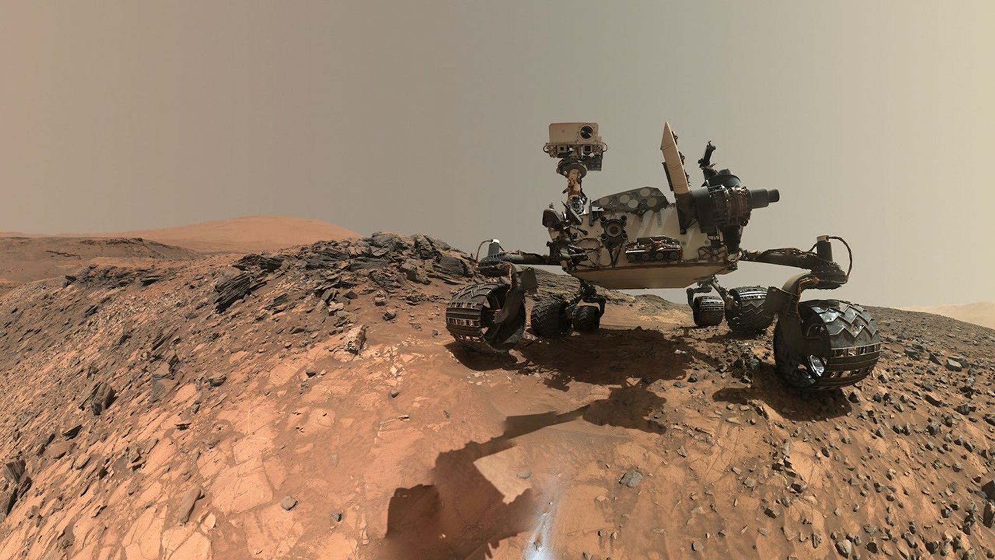
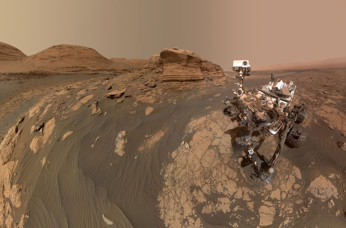
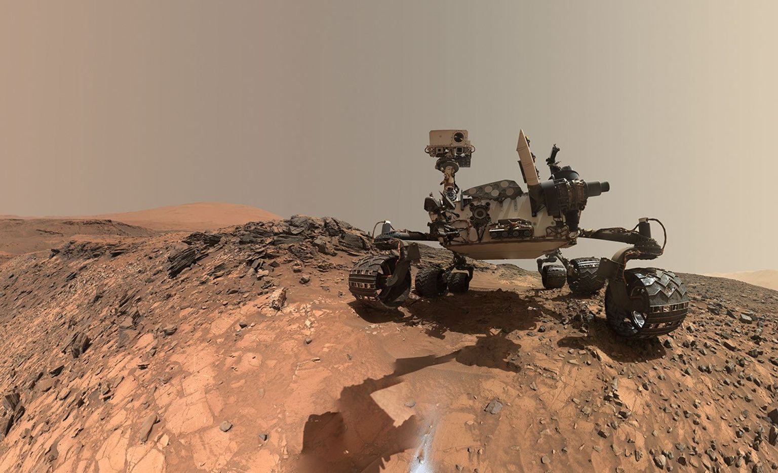
A rover sits on the hilly, orange Martian surface beneath a flat grey sky, surrounded by chunks of rock.
NASA’s Curiosity rover at the base of Mount Sharp
NASA/JPL-Caltech/MSSS

Share

Details

Last Updated
Jun 24, 2026

Related Terms

  •  

Curiosity Blog, Sols 4927–4933: Let’s Drive to That Smooth Area

4 min read

Curiosity Blog, Sols 4927–4933: Let’s Drive to That Smooth Area

A black-and-white landscape photograph of the Martian surface taken by the Curiosity rover. The ground features a heavily textured, polygonal cracked pattern, with light-colored material forming raised veins or ridges along many of the cracks. Several dark, flat rock slabs and smaller loose rocks are scattered across the foreground and middle ground. On the right side of the image, the textured tread marks of the rover's wheels are clearly visible pressed into the soil, curving slightly as they trail off into the distance.
NASA’s Mars rover Curiosity acquired this image showing a breathtaking diversity of polygons, veins, and other textural features waiting for investigation by the Mars Science Laboratory team. Curiosity captured the image using its Left Navigation Camera on June 17, 2026 – Sol 4928, or Martian day 4,928 of the Mars Science Laboratory mission – at 17:47:52 UTC.
NASA/JPL-Caltech

By Susanne P. Schwenzer, Professor of Planetary Mineralogy at The Open University, UK

Earth planning date: Thursday, June 18, 2026

In the area Curiosity is currently exploring, the science team has mapped several areas with different-looking surface texture on the orbital images. If you wanted to have a look yourself at what there is to see, check the “Where is Curiosity?” map. You’ll discover different shades of orange and beige as well as more rough and more smooth-looking textures. This is what the geomorphologists in our team use to map the areas for exploration by the rover. Of course, we then supplement this all with ground-based images, including bespoke “drive direction imaging,” which is taken after each drive by the Mast Camera. Drive planning is done using a combination of all this information. So there shouldn’t be any surprises, right?

On Monday the team planned three sols in preparation for a Thursday planning to account for the U.S. federal holiday weekend. The workspace turned out to be a little spiky, so we could not find an area we could DRT. APXS still found one good bedrock target, “Rio Baker,” which also had MAHLI documentation. In addition, ChemCam investigated “Rica Aventura,” a textured bedrock, and “Tabebuia,” a darker-looking individual block, using its LIBS and conducted a passive spectral observation on a second dark float block called “Lago Ranco.” Of course, the team also wanted to look into the distance with ChemCam remote imaging, extending our investigation of the Cordillera base outcrop.

Imaging is always high on the list. In Monday’s plan Mastcam is looking into the modern dunes with the “Tacaza” mosaic, and with more mosaics looking forward to the future parking areas, some of which looked really smooth from that vantage point. We also continue our environmental and atmospheric observations looking for dust devils, the opacity of the atmosphere, and monitoring pressure and temperature. After all this, the rover drove about 35 meters (about 115 feet) to an area that looked really smooth in all images we had available at that point. So we were hoping for a good spot to deploy the DRT, but didn’t think we could be in for a surprise.

The drive ended exactly as planned, spot-on in the middle of that — from a distance — smooth-looking area. But when we opened the post-drive images on Thursday morning, we were all reacting with a lot of surprise. From up close, the parking spot looks anything but smooth. You can see the surprise in the title image of this blog. There are polygons, veins, lamination, and probably more, once we inspect the higher-resolution images taken today. “Higher-resolution” is the key for why we were in for such a surprise! The features are quite small, a few centimeters across, and therefore we could not see them in the orbital images or from a distance in our navigation and mast camera images. The camera resolution from a distance just isn’t enough to see them. But up close, the terrain revealed all its beauty! And I am sure there will be more in the even higher resolution of today’s MAHLI and ChemCam RMI imager images!

So, what did we plan after we caught our breath on Thursday? First, you guessed it, images, images, and more images. Mastcam takes a full panorama with its “left eye” and adds a range of closer-up mosaics with its higher-resolution “right eye.” In addition there is a ChemCam Remote Micro Imager image to document structures further afield at high resolution. ChemCam is investigating three targets using LIBS: “Rio Chimore” is a lighter-toned band; you can see some of those in the cover image of this blog, too. The other two LIBS targets are “Rio de Lava,” a vein target, and “Rio de Salta,” one of the polygons. APXS is also looking at the bedrock and the ridges, at the targets “Pampa Grande” and “Iquique Ridge.” MAHLI is having the above-mentioned close “hand lens” look. Let’s see what we will discover when we get those images.

Finally, Curiosity drove up the hill along very smooth-looking terrain that is just littered with tiny polygons. Let’s see if we are in for another surprise reverberating around all our offices — and across two continents, as I had the good fortune to be among the first ones, here in England (Or maybe it was our French ChemCam colleagues, who are in a time zone one hour ahead of me?). Whichever it is, this terrain has a lot to say about the geologic history of Mars!

A rover sits on the hilly, orange Martian surface beneath a flat grey sky, surrounded by chunks of rock.
NASA’s Curiosity rover at the base of Mount Sharp
NASA/JPL-Caltech/MSSS

Share

Details

Last Updated
Jun 24, 2026

Related Terms

The post Curiosity Blog, Sols 4927–4933: Let’s Drive to That Smooth Area appeared first on NASA Science.

  •  

Playing the Moon Game 

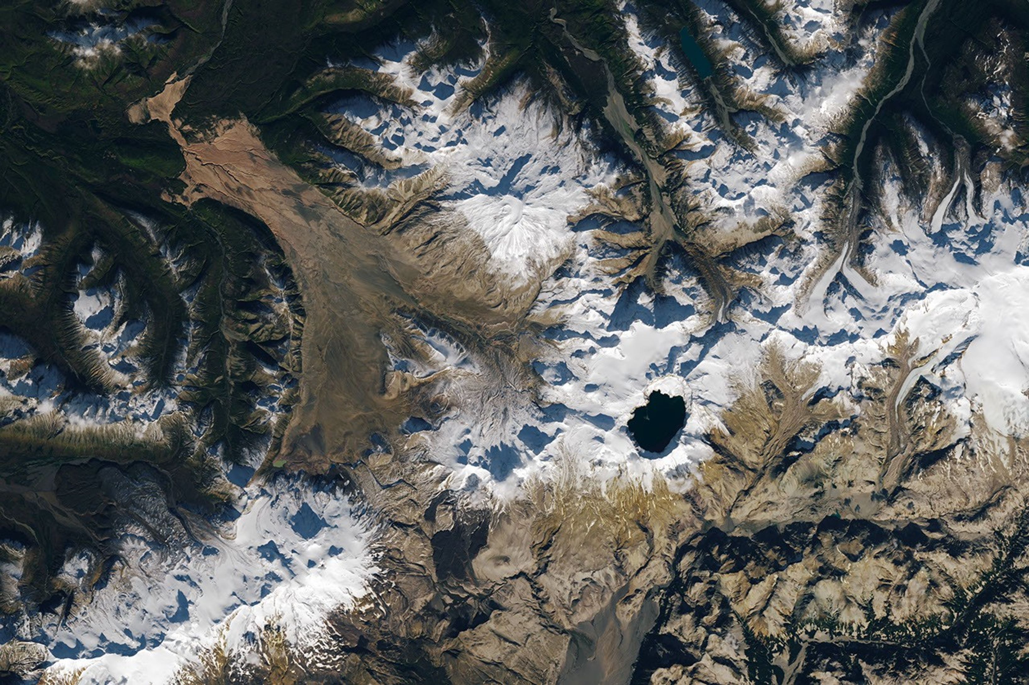
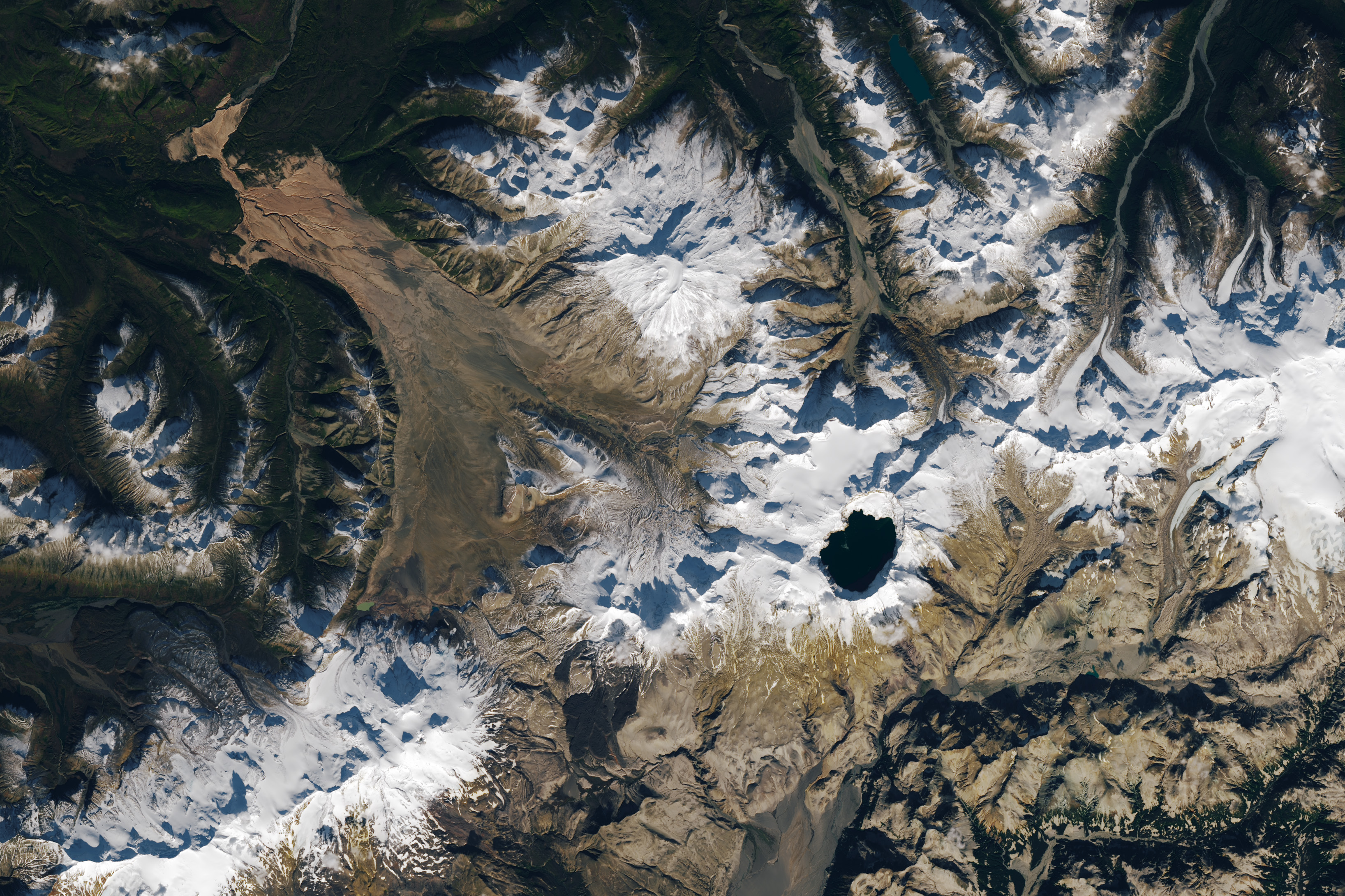
A satellite image shows part of Alaska’s Katmai National Park. A chain of snowy mountain peaks stretches from the bottom left corner to the right side of the image. The Valley of Ten Thousand Smokes is a long, tan-colored feature runs toward the northwest in the upper-left.
September 29, 2025

In preparing to visit the Moon’s surface, soon-to-be lunar explorers in NASA’s Apollo program first ventured into a variety of unfamiliar landscapes on Earth. A couple of these trips, in the summers of 1965 and 1966, took astronauts to Alaska’s remote Katmai National Park for simulations of field geology in Moon-like environments.

In one exercise, which they called “playing the Moon game,” pairs of astronauts were placed at unfamiliar field sites and asked to pretend as if they were on the Moon. By the account of William Phinney, Apollo’s science training coordinator, they were tasked with collecting representative geologic samples and practicing how to communicate their observations to scientists.

A detailed satellite image centers on the Valley of Ten Thousand Smokes in Alaska. The tan-colored feature runs southeast-to-northwest. Snowy peaks appear on the right side of the image, and green, forested valleys fill the left side.
September 29, 2025

The Alaskan setting for the Moon game was an unusual volcanic landscape called the Valley of Ten Thousand Smokes. The valley is full of debris deposited by the 1912 eruption of Novarupta—the largest volcanic event on Earth in the 20th century.

The images above, acquired on September 29, 2025, with the OLI (Operational Land Imager) on Landsat 9, show the massive ash flow deposited by Novarupta. The layer measures up to 660 feet (200 meters) thick and was emplaced at a searing 1,380 degrees Fahrenheit (750 degrees Celsius). 

The Valley of Ten Thousand Smokes, shown in the 1917 photo below, is so named because of the abundance of fumaroles—gas and steam-emitting vents—that filled the valley for a decade after the eruption. A few hundred persisted more than 10 years, with some lasting until the 1990s.

Three people stand in the foreground of this black-and-white photo, silhouetted by steam coming from a fumarole. A dark, barren landscape dotted with plumes of rising steam extends into the background.
1917

Scientists initially suspected that the monster eruption occurred at Mount Katmai, a neighboring volcano with a large caldera located 6 miles (10 kilometers) east of Novarupta’s dome. However, they later determined that the eruption actually occurred at Novarupta—whose name means “new eruption”—after stealing magma from beneath Katmai. As the magma chamber emptied, Katmai collapsed, forming the 2.5-mile-wide (4-kilometer-wide) caldera present today.

The volcanic landscape in the Valley of Ten Thousand Smokes is far fresher than the ancient lava flows that formed the Moon’s volcanic features. But for the Apollo astronauts, it offered an “excellent opportunity to view volcanic materials and landforms in nearly pristine condition,” Phinney wrote. They studied evidence of fumaroles and examined vertical sections of the deposits where streams had eroded deep gorges.

This photo shows a broad valley filled with tan-colored volcanic material in the foreground and snowy mountains in the background. The ashy volcanic deposits create a mostly flat valley floor, except where steep-sided chasms formed by erosion run through it.
June 9, 1991

Researchers continue to visit this Alaskan wilderness in search of clues that could help decipher the geology of the Moon and Mars. In 2024, the Goddard Instrument Field Team (GIFT) trekked to the Valley of Ten Thousand Smokes to study its icy volcanic landscape. Like the valley, Mars contains glaciers and ice sheets layered with dust and ash, a dynamic and difficult-to-interpret environment.

Advancing lunar science, the GIFT team also collected samples from rock formations comparable to the Moon’s Gruithuisen Domes. These mysterious features are made of hardened lava with a different composition than the surrounding rock. With more to learn about our nearest celestial neighbor, the spirit of the Moon game lives on in the 21st century.

NASA Earth Observatory images by Lauren Dauphin, using Landsat data from the U.S. Geological Survey. Photos from National Geographic Society Katmai expeditions photographs, Archives and Special Collections, Consortium Library, University of Alaska Anchorage, and from the U.S. Geological Survey Volcano Hazards Program. Story by Lindsey Doermann. 

Downloads

A satellite image shows part of Alaska’s Katmai National Park. A chain of snowy mountain peaks stretches from the bottom left corner to the right side of the image. The Valley of Ten Thousand Smokes is a long, tan-colored feature runs toward the northwest in the upper-left.

September 29, 2025

JPEG (2.64 MB)

References & Resources

You may also be interested in:

Stay up-to-date with the latest content from NASA as we explore the universe and discover more about our home planet.

Scoria Cones on Earth and Mars

7 min read

The hill-shaped features are a sign of explosive volcanic activity—a rarity on the Red Planet.

Article

A Volcanic Medley Near Mammoth Lakes 

4 min read

A massive, old caldera and more recently formed craters shape the landscape in the eastern Sierra Nevada.

Article

A Full Moon Checkup

3 min read

Once a month during the full Moon, Landsat 9 turns from Earth to image the lunar surface, helping keep the…

Article
  •  

Playing the Moon Game 

A satellite image shows part of Alaska’s Katmai National Park. A chain of snowy mountain peaks stretches from the bottom left corner to the right side of the image. The Valley of Ten Thousand Smokes is a long, tan-colored feature runs toward the northwest in the upper-left.
September 29, 2025

In preparing to visit the Moon’s surface, soon-to-be lunar explorers in NASA’s Apollo program first ventured into a variety of unfamiliar landscapes on Earth. A couple of these trips, in the summers of 1965 and 1966, took astronauts to Alaska’s remote Katmai National Park for simulations of field geology in Moon-like environments.

In one exercise, which they called “playing the Moon game,” pairs of astronauts were placed at unfamiliar field sites and asked to pretend as if they were on the Moon. By the account of William Phinney, Apollo’s science training coordinator, they were tasked with collecting representative geologic samples and practicing how to communicate their observations to scientists.

A detailed satellite image centers on the Valley of Ten Thousand Smokes in Alaska. The tan-colored feature runs southeast-to-northwest. Snowy peaks appear on the right side of the image, and green, forested valleys fill the left side.
September 29, 2025

The Alaskan setting for the Moon game was an unusual volcanic landscape called the Valley of Ten Thousand Smokes. The valley is full of debris deposited by the 1912 eruption of Novarupta—the largest volcanic event on Earth in the 20th century.

The images above, acquired on September 29, 2025, with the OLI (Operational Land Imager) on Landsat 9, show the massive ash flow deposited by Novarupta. The layer measures up to 660 feet (200 meters) thick and was emplaced at a searing 1,380 degrees Fahrenheit (750 degrees Celsius). 

The Valley of Ten Thousand Smokes, shown in the 1917 photo below, is so named because of the abundance of fumaroles—gas and steam-emitting vents—that filled the valley for a decade after the eruption. A few hundred persisted more than 10 years, with some lasting until the 1990s.

Three people stand in the foreground of this black-and-white photo, silhouetted by steam coming from a fumarole. A dark, barren landscape dotted with plumes of rising steam extends into the background.
1917

Scientists initially suspected that the monster eruption occurred at Mount Katmai, a neighboring volcano with a large caldera located 6 miles (10 kilometers) east of Novarupta’s dome. However, they later determined that the eruption actually occurred at Novarupta—whose name means “new eruption”—after stealing magma from beneath Katmai. As the magma chamber emptied, Katmai collapsed, forming the 2.5-mile-wide (4-kilometer-wide) caldera present today.

The volcanic landscape in the Valley of Ten Thousand Smokes is far fresher than the ancient lava flows that formed the Moon’s volcanic features. But for the Apollo astronauts, it offered an “excellent opportunity to view volcanic materials and landforms in nearly pristine condition,” Phinney wrote. They studied evidence of fumaroles and examined vertical sections of the deposits where streams had eroded deep gorges.

This photo shows a broad valley filled with tan-colored volcanic material in the foreground and snowy mountains in the background. The ashy volcanic deposits create a mostly flat valley floor, except where steep-sided chasms formed by erosion run through it.
June 9, 1991

Researchers continue to visit this Alaskan wilderness in search of clues that could help decipher the geology of the Moon and Mars. In 2024, the Goddard Instrument Field Team (GIFT) trekked to the Valley of Ten Thousand Smokes to study its icy volcanic landscape. Like the valley, Mars contains glaciers and ice sheets layered with dust and ash, a dynamic and difficult-to-interpret environment.

Advancing lunar science, the GIFT team also collected samples from rock formations comparable to the Moon’s Gruithuisen Domes. These mysterious features are made of hardened lava with a different composition than the surrounding rock. With more to learn about our nearest celestial neighbor, the spirit of the Moon game lives on in the 21st century.

NASA Earth Observatory images by Lauren Dauphin, using Landsat data from the U.S. Geological Survey. Photos from National Geographic Society Katmai expeditions photographs, Archives and Special Collections, Consortium Library, University of Alaska Anchorage, and from the U.S. Geological Survey Volcano Hazards Program. Story by Lindsey Doermann. 

Downloads

A satellite image shows part of Alaska’s Katmai National Park. A chain of snowy mountain peaks stretches from the bottom left corner to the right side of the image. The Valley of Ten Thousand Smokes is a long, tan-colored feature runs toward the northwest in the upper-left.

September 29, 2025

JPEG (2.64 MB)

References & Resources

You may also be interested in:

Stay up-to-date with the latest content from NASA as we explore the universe and discover more about our home planet.

Scoria Cones on Earth and Mars
7 min read

The hill-shaped features are a sign of explosive volcanic activity—a rarity on the Red Planet.

Article
A Volcanic Medley Near Mammoth Lakes 
4 min read

A massive, old caldera and more recently formed craters shape the landscape in the eastern Sierra Nevada.

Article
Restless Kīlauea Launches Lava and Ash
3 min read

Episode 43 of the Hawaiian volcano’s current eruption was marked by high lava fountains and widespread ash dispersal.

Article

The post Playing the Moon Game  appeared first on NASA Science.

  •  
❌