 Login

Evolution of Biological Information: Lizards and a “New” Organ
The first experiment that Christoph Adami discusses is one where scientists transported lizards from one island to another.


Seen from space, the Danger Islands along Antarctica’s rocky coastline have a distinctive pink-orange coloration, with tiny trails of pink closer to its shorelines.
However, the unique colors of these islands aren’t attributable to minerals, colorful lichens, or other kinds of usual causes. According to NASA, the Danger Islands look the way they do because of their iconic residents.
Now, data about the influence these creatures have on their surrounding habitat his helping scientists monitor the health of an entire Antarctic ecosystem from space.
According to a new study’s findings, the vast colonies of Adélie penguins on the Danger Islands are the culprit behind their coloration. More specifically, it is the guano these flightless birds produce that has permanently altered their coloration when seen from space, resulting in pink stains along the shoreline environments where these waddling creatures reside.
Surprisingly, the guano stains offer an effective means of tracking the diets of these birds, which can serve as a good proxy for the broader changes occurring in Antarctica’s marine environment.

Primarily, this is because these large penguin colonies can deposit enough guano that their presence is detectable in satellite imagery, as is revealed in Landsat satellite imagery collected since the mid 1980s. The distinctive pinkish hue observed on the Danger Islands today indicates a diet rich in krill, whereas eating more fish would produce very different color signatures—all of which can be detected through satellite observations.
For the new research, scientist Casey Youngflesh with the Department of Biological Sciences at Clemson University, along with her coauthors, analyzed more than three decades of Landsat satellite imagery collected from 1984 through 2013.
These observations, combined with samples collected from field studies involving penguin colonies, helped the researchers establish links between specific color patterns and the balance of krill and fish in the birds’ diets.
Among the team’s findings, the data revealed a very close relationship between penguin food sources and the extent of sea ice in the surrounding area, particularly during the breeding season of these shore-dwelling birds.

Colonies of penguins along the warmer Antarctic Peninsula and West Antarctica—locations where there is less sea ice—revealed a greater reliance on krill. By contrast, Eastern Antarctic penguins consumed more fish in areas where sea ice persisted for longer. This higher-quality food source is also linked to improved chick growth and a greater degree of overall population success in the long term.
“Sea ice is such a hugely important factor in the Antarctic marine environment,” said Youngflesh. “The structure of the region’s food web is changing in response.”
Along with what the team’s findings reveal about the lives and sustenance patterns of penguins, they also bring to mind several questions about the future of their habitat.
Although sea ice in Antarctica was found to be primarily stable during the years Youngflesh and her team examined, since 2013 it has shrunken significantly, reaching record low levels. Further declines are expected in the decades ahead, signaling changes that could push Adélie penguins toward increasingly krill-dependent diets.
This could become complicated as commercial krill fishing has seen expansion in recent years, and recovering populations of whales and seals are also competing for the same food source.
Right now, researchers are working to produce new computer models based on data obtained from the Landsat 8 and Landsat 9 satellites, which will help them continue to observe penguin diets from orbit. This data provides an unusual—but also a remarkably effective—means of monitoring the changing health of Antarctica’s fragile ecosystem.
The findings were reported in a new study, “Space-based monitoring of penguin diet links sea ice, food webs, and population change,” which appeared in the journal Current Biology on July 20, 2026.
Micah Hanks is the Editor-in-Chief and Co-Founder of The Debrief. A longtime reporter on science, defense, and technology with a focus on space and astronomy, he can be reached at micah@thedebrief.org. Follow him on X @MicahHanks, and at micahhanks.com.

Thousands of years ago, Scotland’s early inhabitants were building mysterious artificial islands in lakes throughout the region—and now archaeologists have uncovered evidence that reveals these curious aquatic features to be far older than once thought.
Scattered throughout Scotland’s ancient lochs, these curious structures—known as crannogs—have long intrigued archaeologists and historians, partially due to the questions about their age.
Now, artifacts recovered from these human-built islands are pushing back the timescales on their construction, causing researchers to have to reconsider the origins of one of the most enigmatic lacustrine features in the British Isles.
Crannogs have been known to archaeologists for some time, with some of the earliest extensive explorations of these features undertaken beginning more than a century ago by Odo Blundell, a monk at Fort Augustus Abbey.

Constructed mostly from stone and timber, speculations about their creation extend to as early as the Bronze Age, although most scholars believe these curious features were likely to have been an invention of the Iron Age.
However, a surprising recent discovery is now challenging that presumption, revealing that some of these artificial islands date back to more than 5,000 years ago, having been built during Scotland’s Neolithic era.
The story began to unfold in 2012 when local diver Chris Murray was exploring a crannog near the Isle of Lewis in Scotland’s Outer Hebrides. There, he discovered fragments of ancient pottery that experts at the National Museum of Scotland later examined, revealing an astonishing discovery: the remains of artifacts unequivocally associated with the Neolithic period.
The implication was obvious: for Neolithic pottery to have been found on this crannog would indicate it must have been constructed thousands of years earlier than the past dating of these artificial islands.

The discovery prompted a deeper look at the region’s ancient artificial islands, which soon revealed additional evidence of their Neolithic provenance. During the research, Stephanie Blankshein, a maritime archaeologist at the University of Southampton, and colleagues discovered that organic materials and artifacts from several sites across Scotland’s Outer Hebrides indicated these crannogs were likely built sometime between 4,000 and 2,500 BCE.
At least 11 crannogs in the region, Blankshein and her colleagues say, were created during the Neolithic period, pushing back the date of their construction to as far back as six thousand years ago.
One of the most intriguing aspects of the team’s findings involves what it reveals about the ingenuity of the early farming communities in the British Isles, since the new dating of these prehistoric artificial islands indicates that they must have been constructed within just a few centuries of when their ancient builders arrived in the region.
Such findings align well with past genetic studies, which indicate that the region’s Neolithic populations likely descended from farmers who made their way from the Near East through Europe, and eventually settled in the British Isles, where they made their new homes by the sea.
It remains unclear, however, whether the construction of crannogs had been an innovation that occurred after they arrived in Britain, or if this had been a much earlier practice these people brought with them.
Among the most remarkable crannog sites is one found at Loch Bhorgastail on the Isle of Lewis. This artificial island was initially believed to have been primarily built from stone, with some evidence of timber used as reinforcement.
However, underwater excavations by Blankshein and her colleagues soon uncovered something very surprising hidden below the crannog: a massive timber platform supporting the entire structure.

“As excavation advanced, it quickly became apparent that the terrestrial and underwater components formed a single continuous structure spanning both environments and could not be treated separately,” Blankshein and her colleagues write in a recent study detailing their research at the site.
During their underwater surveys, the team discovered that the wooden foundation extended beneath the entire island and dated to between 3500 and 3300 BCE. Measuring approximately 75 feet (23 meters) across, the platform may have originally sat in shallow water or even remained dry during parts of the year.
“Loch Bhorgastail provided a rare opportunity to develop, test, and refine a workflow capable of achieving terrestrial-grade accuracy underwater,” the research team writes. “The site demonstrates the potential of shallow-water archaeology to bridge the land–water interface while elevating the precision and reliability of underwater recording.”
A fundamental question that remains about these curious Neolithic constructions has to do with what their purpose was.
One clue may arrive in the form of residues found on the recent pottery discoveries at several of these sites, which indicate they were used to transport food. This may suggest the crannogs were locations where ancient people prepared and consumed meals, possibly during ceremonial gatherings.
However, it is also possible that these ancient structures served multiple purposes, ranging from sites for communal feasting to possible locations for meetings.
Despite the lingering questions about their use by Scotland’s ancient inhabitants, Blankshein and her colleagues saw these marvelous Neolithic structures as an ideal target for high-resolution shallow-water photogrammetry, which became the focus of her team’s recent research.
“Coastal, riverine, and lacustrine environments have played a central role in the development of human societies, yet locating and documenting this record of activity in littoral environments has proven difficult,” the team writes.
As a result of their research, the team’s findings, combined with recent archaeological discoveries from over the last decade or more, help to shed new light on Britain’s ancient past, while advancing the development of new archaeological approaches. This includes groundbreaking methods for creating 3D models of shallow underwater sites, which the team achieved by using paired action cameras.
As investigations continue, Blankshein and her colleagues suspect many more Neolithic crannogs remain hidden beneath the waters of Scotland and Ireland, and with their discovery and investigation, the potential for further advancements in understanding Europe’s earliest farming societies.
The team’s recent paper, “At the Water’s Edge: Photogrammetry in Extreme Shallow-Water Environments,” appeared in Advances in Archaeological Science.
Micah Hanks is the Editor-in-Chief and Co-Founder of The Debrief. A longtime reporter on science, defense, and technology with a focus on space and astronomy, he can be reached at micah@thedebrief.org. Follow him on X @MicahHanks, and at micahhanks.com.
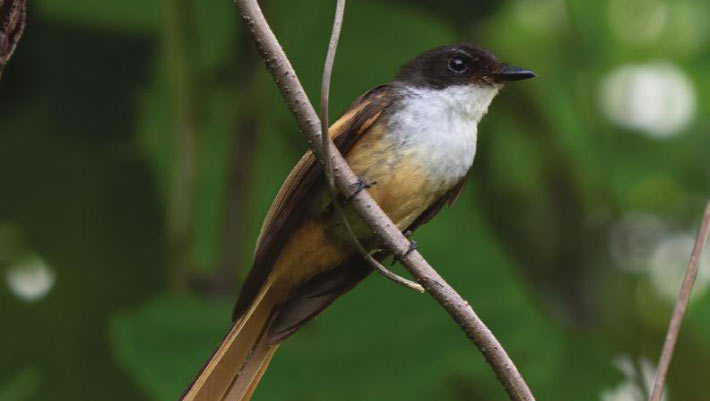
A small songbird inhabiting the Babar Islands, in the Banda Sea, Indonesia, has been identified as a new species after a duo of researchers discovered that its distinctive song sets it apart from its closest relative.
The post Ornithologists Describe New Bird Species from Remote Indonesian Islands appeared first on Sci.News: Breaking Science News.
Government rejects offshore rubbish being shipped to Fiji and burned after opposition from traditional landowners and tourism operators
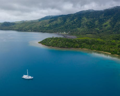
The Fijian government has rejected a plan by an Australian billionaire to burn rubbish for energy in Fiji after backlash from traditional landowners and tourism operators.
The plan to ship non-recyclable rubbish from across the region to Fiji, popular with tourists for its pristine beaches, and build an incinerator to consume 900,000 tonnes of waste a year had been labelled “waste colonialism” by villagers.
Continue reading...
© Photograph: BigBlueFun/Getty Images/500px
© Photograph: BigBlueFun/Getty Images/500px

© Photograph: BigBlueFun/Getty Images/500px
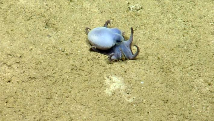
A single female specimen, collected 1,773 m below the surface near Darwin Island, has been described as a new species of deep-sea octopus, and it doesn’t fit neatly into the Megaleledonidae family it belongs to, forcing a revision of the textbook definition.
The post New Species of Octopus Discovered in Deep Waters near Galapagos Islands appeared first on Sci.News: Breaking Science News.
