Rivers serve as the lifeblood of our planet, weaving through landscapes and ecosystems while sustaining human civilizations. Despite their critical importance, many rivers remain under-studied, often due to the difficulties presented by their accessibility and variability. Small streams can be intermittent and unpredictable, sometimes disappearing for months or even years. This presents a formidable challenge for hydrologists and environmental scientists tasked with understanding these dynamic systems and their impact on water resources. Now, cutting-edge satellite remote sensing technology is revolutionizing how researchers monitor and analyze river health and water quality on a global scale.
Professor Dongmei Feng of the University of Cincinnati is at the forefront of this emerging discipline. Specializing in hydrological modeling and remote sensing, Feng recognizes that satellite data offers an unprecedented opportunity to observe rivers wherever they flow, even those in remote or inaccessible regions. Through spectral analysis of satellite imagery, scientists can detect changes in water quality and identify key pollutants, nutrients, and biological stressors that are difficult to measure through traditional fieldwork alone. This technology enables continuous and comprehensive monitoring, which is essential in managing freshwater resources sustainably.
The article recently published in Nature Water by Feng and her international collaborators underscores the importance of a holistic yet detailed approach to river science. By combining systematic review techniques with satellite-based observations, the researchers advocate studying rivers both individually and collectively. Each river exhibits a unique combination of climatic conditions, geographical features, and human impacts, which influence its health and quality. Understanding these nuances at multiple scales is crucial for predicting the rivers’ response to environmental pressures and human activities.
Rivers are not isolated entities; they are integral to planetary processes, acting as conduits connecting terrestrial landscapes with oceans and the atmosphere. The sediment and nutrients transported from rivers to estuaries serve as essential nourishment for diverse marine ecosystems. Estuaries themselves act as critical breeding grounds and nurseries for countless marine species, making the health of upstream river systems vital to ocean biodiversity. Satellite remote sensing provides a powerful lens through which to monitor these interactions in near real-time with astonishing spatial coverage.
One of the most pressing global environmental concerns linked to river systems is nutrient pollution, which frequently leads to harmful algal blooms. These blooms, fueled by excess nitrogen and phosphorus from fertilizer runoff and sewage discharge, pose severe risks to public health and aquatic ecosystems. Professor Feng’s ongoing research, supported by a substantial grant from the National Science Foundation, aims to unravel nutrient dynamics over the past five decades across multiple rivers worldwide. This extensive historical analysis is anticipated to improve early warning systems, allowing water managers to preemptively respond to developing algal blooms before they reach toxic levels.
The biogeochemical cycles underlying these nutrient movements involve complex feedback mechanisms. Algal blooms block sunlight from penetrating the water column, suffocating submerged vegetation that supports aquatic life. Upon decomposition of the dead algae, oxygen levels in the water plummet, creating ‘dead zones’ where fish and other organisms cannot survive. This process, known as eutrophication, exemplifies how human-induced nutrient loading can trigger cascading ecological failures. Understanding and modeling this cycle is critical for devising targeted mitigation strategies.
Satellite technology, combined with sophisticated computer modeling, is revolutionizing the ability to track water quality parameters such as turbidity, chlorophyll concentration, and dissolved organic matter with unprecedented precision. Dr. Xiao Yang from Southern Methodist University highlights how spectral signatures obtained from satellites can differentiate among various pollutants and ecological indicators. This technological advancement enables continuous global surveillance and geographically detailed water quality assessments that were not feasible before.
The applications of these remote sensing tools extend beyond academic research; they have real-world implications for managing urban infrastructure and protecting public health. Cities that rely heavily on river water for drinking need accurate and timely data to prevent toxic algal contaminants from entering treatment plants. Given that around 90% of the world’s population lives within six miles of a river, technological breakthroughs in monitoring river systems have direct societal benefits, including safeguarding drinking water, supporting recreational activities, and preserving biodiversity.
Moreover, this satellite-enabled river science promises to illuminate previously hidden aspects of hydrological variability and change. By tracking fluctuations in river flow and quality across diverse climatic zones, researchers hope to better understand how climate change will impact freshwater availability and ecosystem services. The integration of historical datasets with contemporary remote sensing observations offers a pathway to predictive models that inform adaptation and conservation efforts worldwide.
The multidisciplinary collaboration evident in Feng’s study incorporates expertise from hydrology, environmental engineering, satellite physics, and data science. Such integrative research approaches are becoming increasingly necessary to tackle complex environmental challenges that span geographic and disciplinary boundaries. The comprehensive global perspective championed in this research paves the way for a new era of river science, where policy decisions and resource management are underpinned by data-driven insights and continuous observation.
As research progresses, the challenge will be to translate these tremendous amounts of data into actionable knowledge. This entails developing user-friendly platforms for water managers and policymakers to interpret satellite-derived information effectively. Ensuring accessibility while maintaining scientific rigor requires ongoing innovation in data analytics and communication. Nonetheless, the promise of these technological tools to safeguard freshwater resources against pollution and ecological degradation has galvanized the scientific community and stakeholders alike.
In conclusion, the integration of satellite remote sensing into river science marks a transformative advancement in understanding and managing one of Earth’s most essential natural resources. Pioneered by experts such as Professor Dongmei Feng, this approach enables scientists to overcome traditional barriers to studying rivers, track nutrient pollution trends, and predict ecological threats such as toxic algal blooms. As the global population continues to grow and climate change accelerates, technologies that provide real-time, global-scale insights into river ecosystems are indispensable for sustainable water management and environmental protection.
Subject of Research: Hydrology, water quality control, and nutrient dynamics in rivers using satellite remote sensing technology.
Article Title: Remote sensing and the new global river science
Scientists have found a way to make GPS remarkably accurate in city “urban canyons,” where navigation has long gone wrong. Most of us trust that the location shown by our GPS is accurate. But anyone who has tried navigating an unfamiliar city knows that is not always the case. You may be walking steadily down [...]
Le prochain vol de la fusée européenne Ariane 6 est prévu pour le 17 juin. Il s'agira du premier décollage dans cette configuration avec quatre nouveaux propulseurs plus puissants pour mettre en orbite la charge utile la plus importante jamais envoyée par ce lanceur.
As the US military readies for two 2027 missions to test spacecraft maneuvering, a new challenge with orbital warehouses aims to beef up space infrastructure.
Elon Musk’s rocket company said it would sell more than 555 million shares at $135 each in its blockbuster initial public offering, which is set to begin trading on Friday.
Two Times tech reporters and their editor talk about assessing the sky-high valuation of the rocket and satellite maker, the potential economic impact of its public debut and the role of the world’s richest man in it all.
SpaceX CEO Elon Musk outlined more details for his company’s planned data centers in space ahead of a widely anticipated IPO on Friday (June 12) expected to make him a trillionaire.
Russian satellites have been identified as the cause of mysterious, seconds-long bursts of GPS interference across Europe—a rare example of human-made GPS interference coming from space. But uncertainty still hangs over whether such interference is intentional and if it could be more powerfully weaponized as GPS jamming with continental reach in the future.
The discovery came from an investigation detailed in a June 2 preprint paper by Todd Humphreys and his student Zach Clements at The University of Texas at Austin, along with Argyris Kriezis at Stanford University in California. By sifting through public data from ground-based stations with global navigation satellite system (GNSS) receivers, they identified a pattern of high-powered interference lasting less than 10 seconds each time but simultaneously detectable by ground stations across Europe from Norway to Spain to Poland, and even reaching as far west as Greenland and Canada.
By analyzing the ground station data from January 2019 to April 2026, the researchers found 75 days with at least one widespread GNSS interference event overlapping with the GPS L1 frequency band centered on 1575.42 megahertz. That represents the main band used for signal transmission by the US-made GPS satellite constellation and GNSS constellations from other countries.
NASA just demonstrated a technology that lets spacecraft communicate across multiple networks, paving the way for a more flexible and reliable space internet. NASA’s experimental Polylingual Experimental Terminal (PExT) has successfully completed its primary technology demonstration, marking an important step toward more flexible communications in space. Because the project met its original goals and continues [...]
NASA launched the Extreme Ultraviolet Explorer satellite, or EUVE, on June 7, 1992, to conduct an all-sky survey at wavelengths inaccessible from the ground. The first satellite designed to operate in the short-wave ultraviolet range, its “objectives included discovering and studying UV sources radiating in this spectral region, and analyzing effects of the interstellar mediumContinue reading "June 7, 1992: The Extreme Ultraviolet Explorer launches"
The outer solar system is inhabited by swarms of small objects that are challenging to observe and characterize. When one of these objects travels in front of a star, from our perspective, the passage provides a brief chance to study these distant, icy denizens of our solar system. In a recent article, Estela Fernández-Valenzuela (University of Central Florida) and coauthors described how they predicted and observed stellar crossings by Weywot, the largest moon of the dwarf planet Quaoar, which lies roughly 44 au from the Sun. In the image above, the black dashed lines indicate the areas where Weywot was predicted to briefly blot out the light from a star, and the blue lines show the updated regions based on Hubble Space Telescope observations. In each panel, the green squares and red circles show where the occultation was and was not detected, respectively. There were five successful detections of Weywot’s passage across a star, allowing the team to constrain Weywot’s diameter to 116–172 km. The team also found that Weywot is much darker than the body it orbits, which has important implications for how the system formed. To learn more about the planning process for and results of these observations, be sure to check out the full research article linked below.
Citation
“Weywot, an Unusually Low-Albedo Satellite in the Trans-Neptunian Region,” Estela Fernández-Valenzuela et al 2026 ApJL1002 L37. doi:10.3847/2041-8213/ae6076
The smallest satellite of the Milky Way, Ursa Major III/UNIONS 1, has posed a mystery since its discovery. Is this smattering of stars a dwarf galaxy or a star cluster?
The Milky Way’s Mysterious Companion
In 2024, researchers discovered a small group of stars orbiting the Milky Way at a distance of about 33,000 light-years in data from the Ultraviolet Near Infrared Optical Northern Survey (UNIONS). This collection of stars amounts to just 16 solar masses and shines with only 11 times the Sun’s luminosity, making it 4–5 times less massive than the next faintest Milky Way satellite.
Considering its small stellar population and small size (its half-light radius is 10 light-years, which is typical for a globular cluster), this satellite appeared at first glance to be an ordinary star cluster. But early data also suggested that the stars had an unusually high velocity dispersion, which could mean that they are nestled within a dense and massive dark matter halo — making the satellite not a star cluster but a dwarf galaxy.
Reflecting this uncertainty, the satellite has two names: Ursa Major III (its dwarf galaxy designation) and UNIONS 1 (its star cluster classification). Can new data clear up the confusion?
New Dispersion Data
In a recent research article, William Cerny (Yale University) and collaborators described new observations of 16 stars in Ursa Major III/UNIONS 1 with the Keck II telescope.
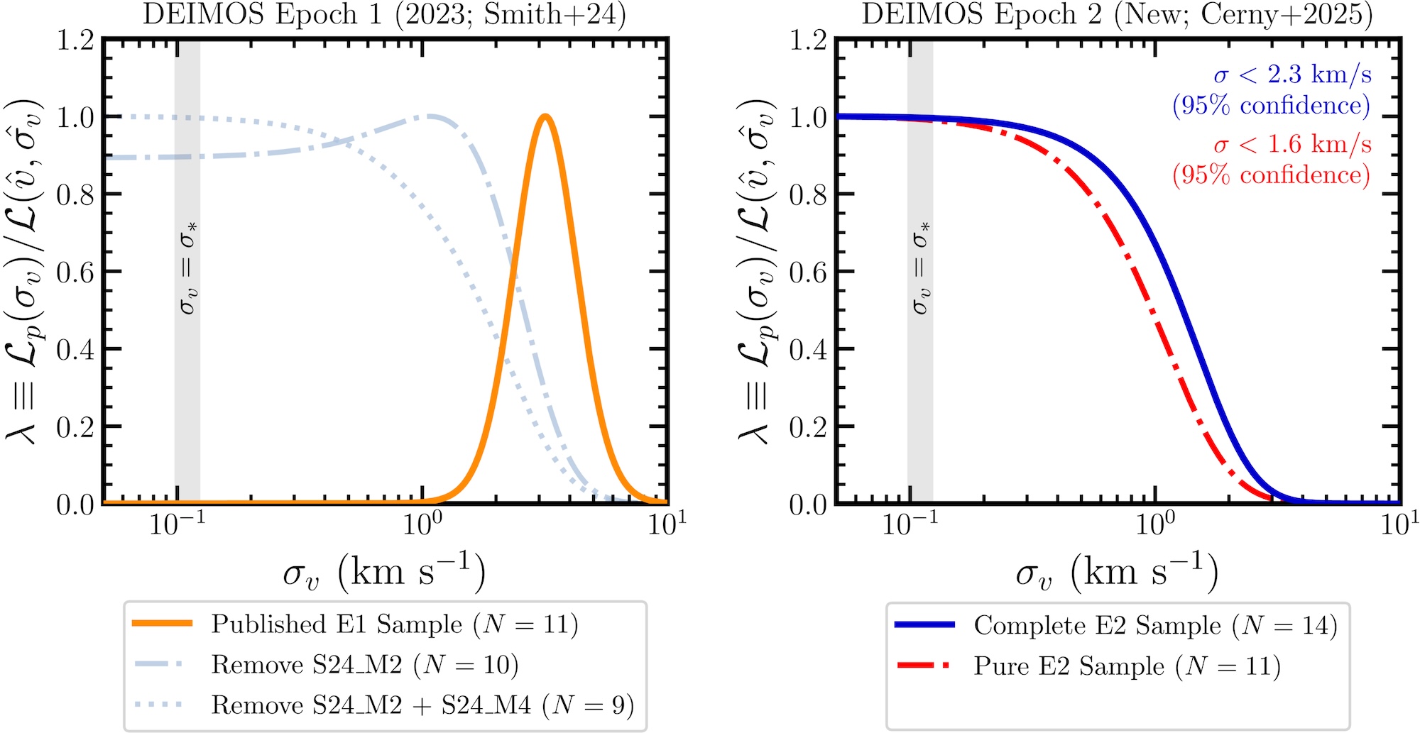
Normalized likelihoods for the velocity dispersion based on the initial data (left) and the new data (right). The initial velocity dispersion measurement of 3.7 km/s is ruled out by the new measurements. Click to enlarge. [Cerny et al. 2026]
Crucially, these measurements enabled a new estimation of the system’s velocity dispersion. In contrast to earlier work that found a high velocity dispersion of 3.7 km/s, the new data favor a value of just 0.1 km/s and rule out values above 2.3 km/s. While these results do not unequivocally preclude the possibility of dark matter, they strongly favor little to no dark matter. This goes against the initial evidence in favor of the dwarf galaxy hypothesis.
These observations also helped to confirm one candidate binary pair and identify three new binary candidates. (This large binary fraction, though interesting, isn’t diagnostic, as both star clusters and dwarf galaxies are known to host high proportions of binary stars.)
Further Evidence
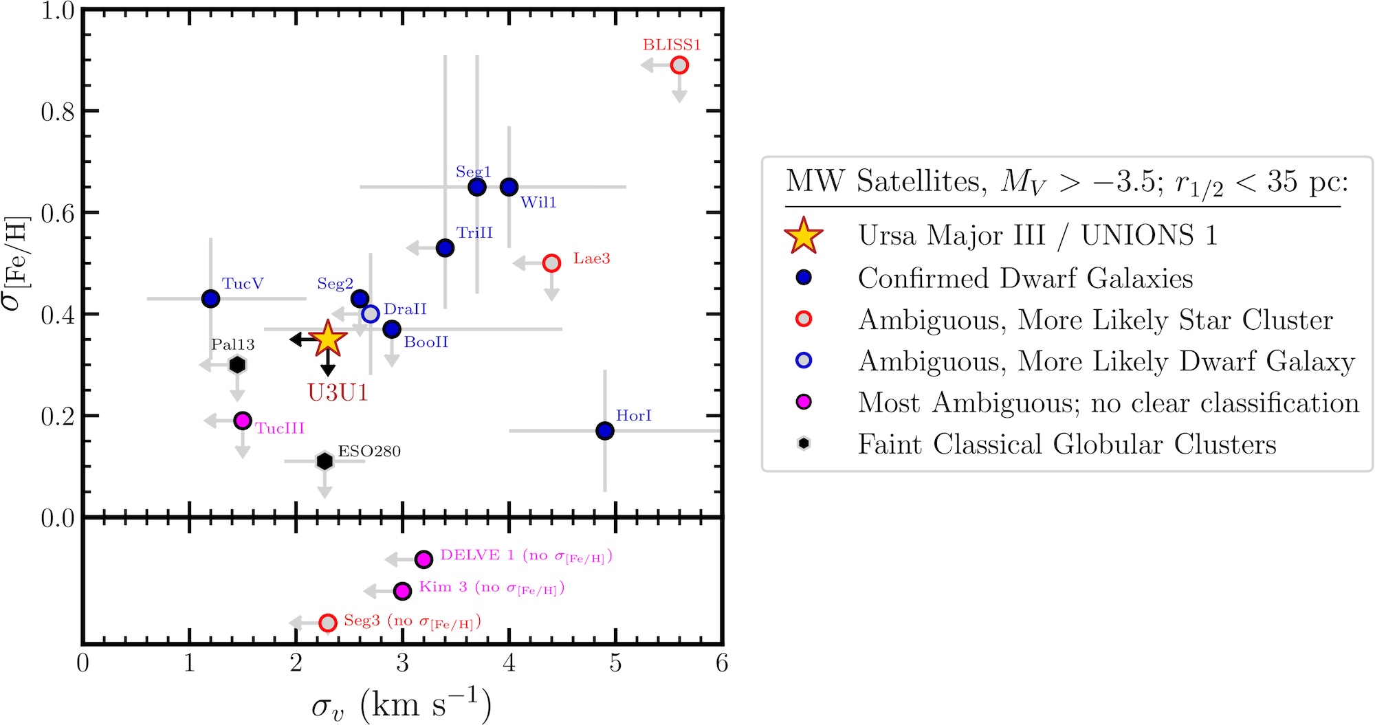
Cerny’s team conducted a further test of the Ursa Major III/UNIONS 1’s identity by measuring the metallicities of its 12 brightest stars. They found that the stars are metal poor and have little metallicity dispersion. This finding again points to a star cluster, in which stars form in a single epoch, rather than a dwarf galaxy, which may feature multiple generations of stars with different degrees of chemical enrichment.
Upper limits on velocity dispersion and metallicity dispersion for Ursa Major III/UNIONS 1 compared to other faint Milky Way satellites. There are no confirmed dwarf galaxies for which the metallicity dispersion and velocity dispersion are both lower than for Ursa Major III/UNIONS 1. Click to enlarge. [Cerny et al. 2026]
Based on the newly collected evidence, Cerny and collaborators concluded that Ursa Major III/UNIONS 1 is likely a star cluster, though the possibility that it’s instead a dwarf galaxy could not be ruled out. If the star cluster classification holds, Ursa Major III/UNIONS 1 would be the least luminous metal-poor star cluster known. This classification may also imply the presence of a large number of compact objects — white dwarfs, neutron stars, or black holes — to keep the cluster intact, filling the role that dark matter would have played.
Going forward, further chemical abundance measurements of Ursa Major III/UNIONS 1 may still sway the argument one way or another. And as facilities like the Vera C. Rubin Observatory and the Euclid space telescope continue to collect data, other extreme Milky Way satellites may come to light.
Citation
“No Observational Evidence for Dark Matter Nor a Large Metallicity Spread in the Extreme Milky Way Satellite Ursa Major III/UNIONS 1,” William Cerny et al 2026 ApJL999 L8. doi:10.3847/2041-8213/ae29b8
Small galaxies are expected to have even smaller companion galaxies, according to current cosmological models. A recent study takes a look at one dwarf galaxy and finds more tiny companions than anticipated.
Cosmology Predicts Satellite Galaxies
Critical to our understanding of dark matter and galaxy formation, satellite galaxies are small, faint galaxies surrounding a larger host galaxy. The leading cosmological model, known as lambda cold dark matter (ΛCDM), predicts dark matter halos of all masses to host smaller dark matter subhalos whose luminous counterparts make up satellite galaxies.
While the satellite systems of Milky Way-like galaxies are well characterized, the companions of dwarf galaxies are less well studied. Despite being significantly smaller, dwarf galaxies should also host even smaller satellites galaxies around them. These satellites push the limits of observations — extremely faint and hard to distinguish from background sources, dwarf galaxy satellites require innovative imaging techniques to discover.
In recent years, new surveys have identified a number of satellites around dwarf galaxies that appear broadly consistent with ΛCDM predictions, though the sample size is still small. Continuing the search for little galaxies’ little galaxies is critical to testing the ΛCDM framework and will further our understanding of galaxy formation on the smallest scales.
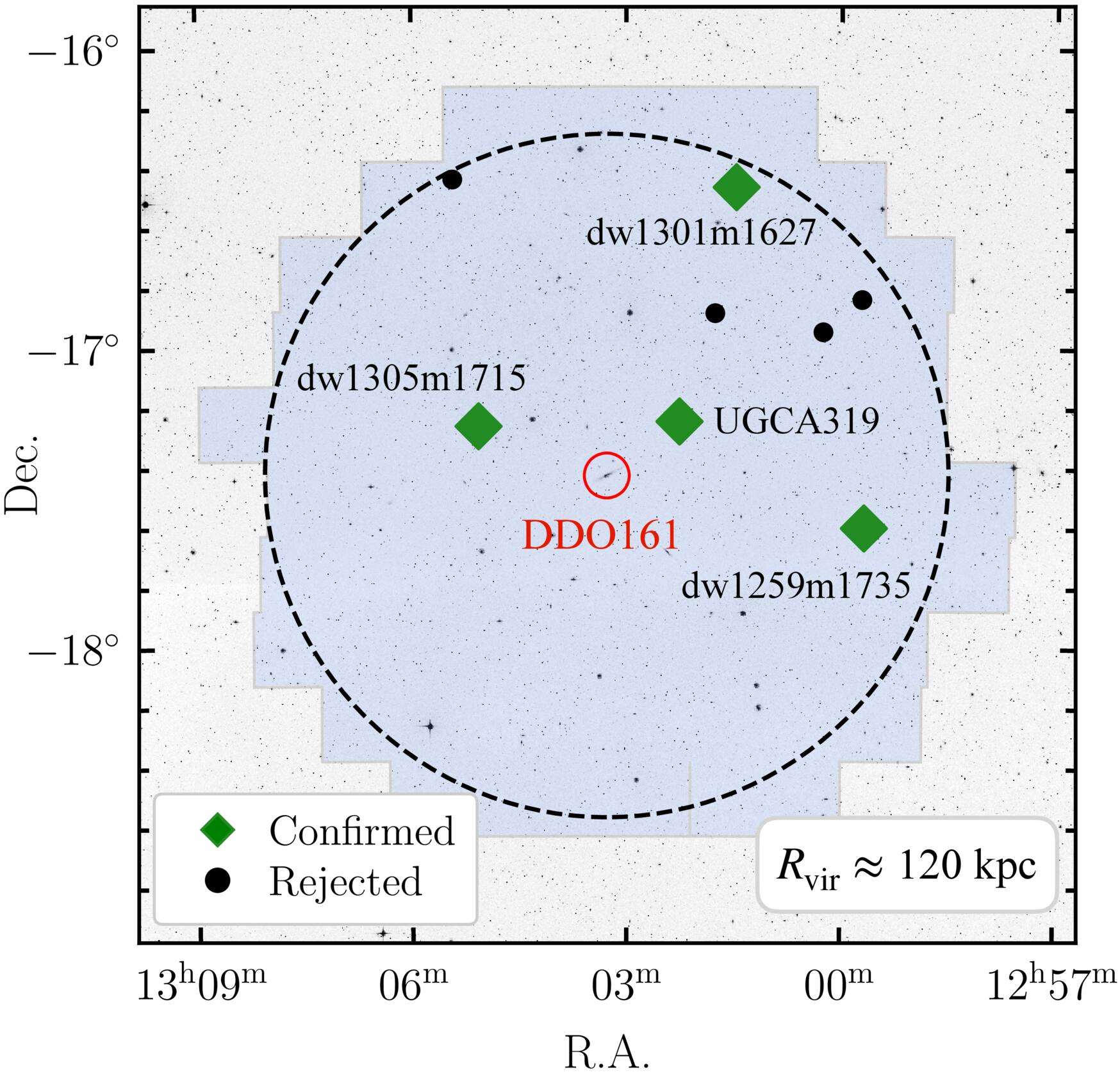
Satellite candidates around DDO 161 as they appear on the sky. Click to enlarge. [Li et al 2026]
Searching for Satellites Around DDO 161
Diving into a specific system, a team led by Jiaxuan Li (李嘉轩) from Princeton University began an in-depth search for satellites around the dwarf galaxy DDO 161. Prior to this study, DDO 161 was known to have one companion, UGCA 319, that is about 10 times smaller than its host.
The authors used data from the Legacy Surveys to search for satellites within about 400,000 light-years of DDO 161 — the expected reach of DDO 161’s gravitational influence. After removing bright sources and smoothing the image to bring out very faint objects, they found eight satellite galaxy candidates including UGCA 319.
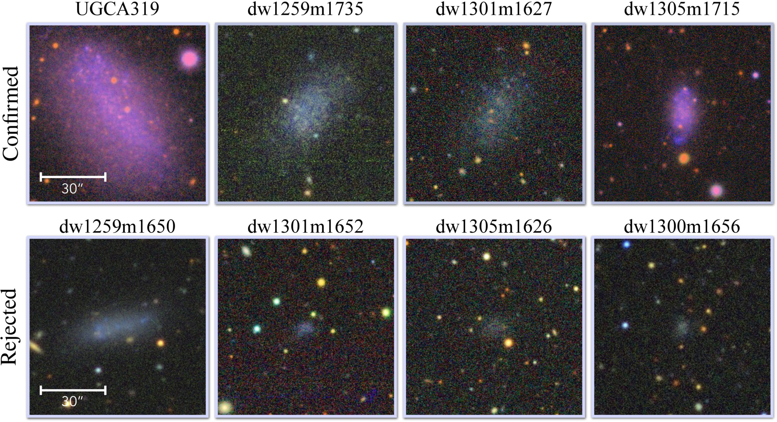
Images of the satellite candidates of DDO 161 from the Legacy Surveys. The top row shows the confirmed satellites, and the bottom row shows the rejected satellites. Click to enlarge. [Li et al 2026]
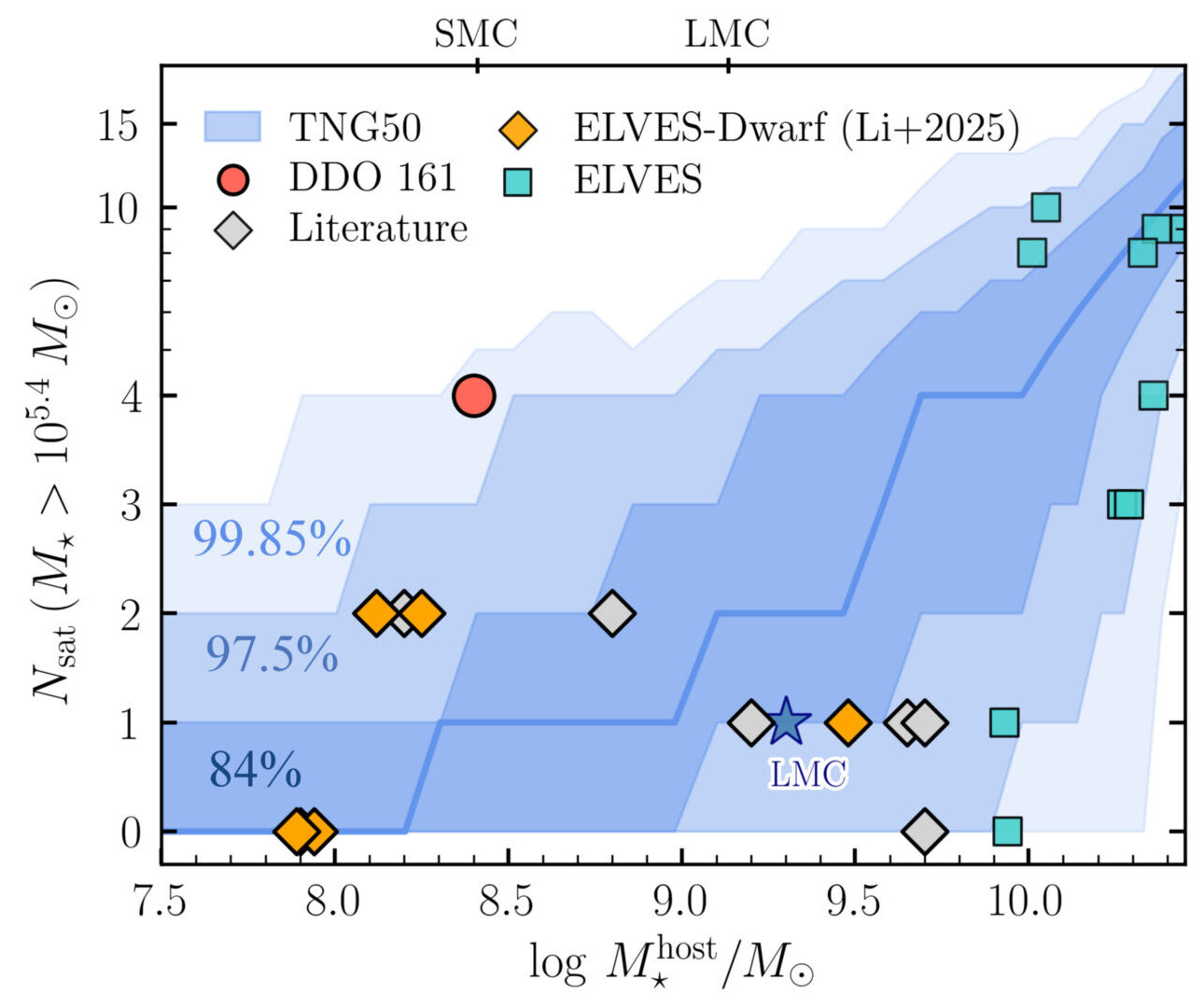
To confirm if these candidates were actual satellites of DDO 161, the team performed follow-up observations of the seven unconfirmed sources with the Magellan 6.2-meter telescope. Using the surface brightness fluctuation technique — measuring how a galaxy’s light fluctuates from pixel to pixel to determine its distance — the authors confirmed that three of the candidates are located at a similar distance to DDO 161 and are likely satellites. With the previously confirmed companion UGCA 319, DDO 161 has four satellite galaxies with stellar masses above 250,000 solar masses, making it the most satellite-rich dwarf galaxy known to date.
Too Many Satellites
How does DDO 161 compare to theoretical predictions for galaxies of its size? The authors ran cosmological simulations to quantify the expected satellite populations around galaxies of similar size to DDO 161. Just as it is an outlier observationally, DDO 161 is also an outlier when compared to the simulation results that predicted fewer satellite galaxies in similarly massive host systems.
Number of satellites versus host galaxy stellar mass for DDO 161 (red circle) compared to other observed low-mass galaxy satellite systems (data points) and predicted ranges from simulations (blue regions). DDO 161 is a clear outlier, having a high number of satellites for the host galaxy’s stellar mass. Click to enlarge. [Modified from Li et al 2026]
Making sure to cover all bases, the authors considered their observational uncertainties, limitations of the simulations, different relationships between stellar and dark matter halo mass, and possible environmental effects. None of these checks could, at this point, sufficiently explain the satellite overabundance in DDO 161, introducing a possible “too-many-satellites” problem for this galaxy. A larger sample of satellites around dwarf galaxies is necessary to better understand this discrepancy, test our current cosmological framework, and give new insight into galaxy formation on small scales.
Citation
“A Possible ‘Too-many-satellites’ Problem in the Isolated Dwarf Galaxy DDO 161,” Jiaxuan Li et al 2026 ApJL998 L24. doi:10.3847/2041-8213/ae3ddd
Gwynne Shotwell, the president and chief operating officer, is the adult-in-the-room foil to Mr. Musk as SpaceX prepares for a blockbuster initial public offering.
 Login


 Scientists have found a way to make GPS remarkably accurate in city “urban canyons,” where navigation has long gone wrong. Most of us trust that the location shown by our GPS is accurate. But anyone who has tried navigating an unfamiliar city knows that is not always the case. You may be walking steadily down [...]


 The new space race is smaller and messier than we anticipated.

 NASA just demonstrated a technology that lets spacecraft communicate across multiple networks, paving the way for a more flexible and reliable space internet. NASA’s experimental Polylingual Experimental Terminal (PExT) has successfully completed its primary technology demonstration, marking an important step toward more flexible communications in space. Because the project met its original goals and continues [...]