❌

Reading view

Using seismic stations to track groundwater resources

In March 2023, Southern California experienced heavy storms after almost 20 years of drought. Sixteen of these came from long, narrow regions of concentrated water vapor moving through the air, known as atmospheric rivers. During droughts, groundwater supplies up to 60% of the total water to the Greater Los Angeles area, so researchers think that stormwater from the 2023 events could have recharged groundwater reserves for future use. However, scientists lack adequate tools to assess how much groundwater is in the subsurface.

To overcome this challenge, researchers from California and Texas developed a new method to study deep groundwater. California gets a large number of earthquakes, so it has over 450 stations around the state to monitor the associated vibrations, referred to as seismic waves. To study how much the 2023 storm recharged the groundwater in the Greater Los Angeles area, the team used a tool called seismic-DI, which employs these seismic waves to estimate how much groundwater is stored at different depths. 

Seismic-DI works by measuring how fast seismic waves move through the Earth, known as their seismic velocity. The researchers explained that the Greater Los Angeles area is a very crowded city, so it produces an abundance of seismic waves. They measured changes in the seismic velocities of these underground waves to see where the groundwater is full of water, or saturated, versus partially full, or unsaturated. They used 20 years of these data to produce graphs that record changes in groundwater storage at different depths, known as hydrographs.

To validate the accuracy of seismic-DI, the researchers also compared their seismic hydrographs with groundwater thickness data from a NASA mission known as the Gravity Recovery and Climate Experiment, or GRACE. GRACE consists of 2 satellites that measure changes in Earth’s gravity, which reflect surface water and groundwater storage. Both their seismic hydrographs and the GRACE groundwater data demonstrated that the Greater Los Angeles region experienced an increase in groundwater storage from stormwater in the winter, and a reduction in groundwater storage during the dry summer. 

The team’s hydrographs showed that the 2023 storms saturated the Greater Los Angeles area groundwater down to 35 meters (114 feet), but it was abnormally dry at 200 meters (656 feet), and at a severe drought at 450 meters (1,476 feet). The GRACE data similarly demonstrated that the subsurface is in severe drought. Combined, these data indicated the 2023 storms helped the Greater Los Angeles area recover up to 90% of its groundwater at depths of 50 meters (164 feet) since the 2006-2022 drought. However, it recovered only about 40% at 75 meters (246 feet) and 20% to 30% at 100 meters (328 feet).

They concluded that the 2023 atmospheric river events recharged only shallow groundwater reserves in the Los Angeles area. As a result, they suggested future researchers consider deep groundwater reserves for a more complete assessment of total regional water deficits. While this study demonstrated that seismic-DI can successfully reveal spatial changes in groundwater and drought at depth, the team acknowledged that contributing factors like the amount, rate, and spatial variability of groundwater reserves remain targets of future work. 

The post Using seismic stations to track groundwater resources appeared first on Sciworthy.
  •  

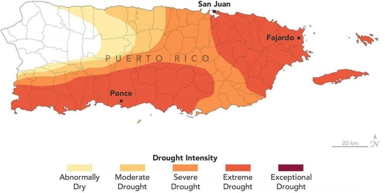
Puerto Rico Went From No Drought to Extreme Drought in Just Months

Puerto Rico Drought 2026Puerto Rico went from no drought to widespread extreme drought in just months as rainfall collapsed and water shortages spread. Puerto Rico usually enters its wet season in May. In 2026, however, the expected rains largely failed to arrive through late August, leaving much of the U.S. territory in drought. The prolonged dry spell has [...]
  •  

Choking Global Trade

Low rainfall and shrinking rivers are causing shipping bottlenecks, and higher prices, around the world.

© Ina Fassbender/Agence France-Presse — Getty Images

The Rhine River near Düsseldorf, Germany, last month.
  •  

New Mexico’s Largest Reservoir Was Nearly Full. Now It’s at 1.4%

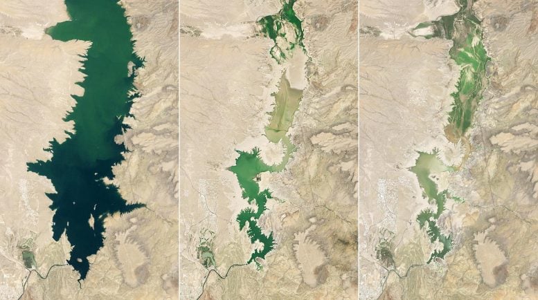
Elephant Butte Reservoir Runs LowNew Mexico’s largest reservoir plunged to just 1.4 percent capacity in July 2026, revealing the dramatic impact of prolonged drought and record early snowmelt. NASA is using satellite data to help water managers understand the shrinking supply and prepare for future shortages. When astronaut John Glenn remarked on the landscape below him while orbiting Earth [...]
  •  

Hurricane Lowell Floods Western Hawaii, New Forest Wildfire Threatens Woodland — Today’s Environmental Briefing for Wed, Sep 9 2026

Flooded roadway with uprooted trees in western Hawaii after Hurricane Lowell

Across the stories today, a common thread emerges: the gap between what protects us on paper and what protects us in practice. Again and again, communities are discovering that designations, promises, and permits only matter when someone is willing to enforce them — and that when systems fail, it’s ordinary people, and often the most vulnerable, who absorb the shock.

Nowhere is that clearer than in Jackson, Mississippi, where a federal appeals court ruled this week that the Constitution guarantees no right to clean water. For residents who have lived through years of contaminated taps and boil-water notices, the decision lands as a gut-punch reminder that legal frameworks haven’t caught up to environmental reality. A similar tension runs through the Guardian’s reporting on datacenter wastewater in Wyoming, where testing turned up a rare, potentially hazardous bacterium, and on English golf clubs, where one in twelve have quietly broken water extraction rules amid growing drought stress. Behind the numbers are real communities adapting in real time — often without knowing what’s actually flowing through their pipes or being pulled from their aquifers.

That same gap between promise and delivery surfaces in the UK’s datacentre boom, which new analysis suggests will produce only a quarter of the jobs once advertised, even as it strains the national grid. It echoes in Georgia, where a once-booming EV manufacturing corridor is hitting turbulence under shifting federal policy — a reminder that industrial transitions built on incentives can be as fragile as the politics that fund them.

Yet the day’s coverage also points to growing momentum around care, restoration, and reckoning. Hurricane Lowell’s damage across Hawaii’s western islands — toppled trees, flooded roads, thousands without power — sits alongside quieter stories of renewal: Gloucestershire’s proposal to reintroduce beavers as a defense against drought and flooding, Douglas Head’s new conservation status on the Isle of Man, and Coventry’s investment in Longford Nature Park. These are small, deliberate acts of stewardship, the kind Wendell Berry spent his life advocating for. His death last week, at 92, feels newly resonant this week — a farmer-poet who insisted that loving a place well was itself a form of environmental action, long before it became policy language.

Farther afield, the human cost of extraction runs deep. In Peru and Brazil, mercury from illegal gold mining is showing up in children’s blood and in fish that families have eaten for generations, forcing painful dietary changes in communities that did little to cause the contamination. In Indonesia, El Niño-fueled fires are pushing orangutans out of burning forests, while in Uttarakhand, India, women — who gather firewood and fodder — are bearing the brunt of increasingly long fire seasons. In Colombia, the Wiwa community’s decision to relocate their village down the mountain is less retreat than adaptation, a recognition that sacred land is changing faster than tradition can hold still.

It’s a reminder that progress and pressure often arrive together — a new spaceport investment in Shetland, a badger vaccination program under scientific scrutiny, a push for a Natural History GCSE to reconnect children with the outdoors. Each represents a small bet on the future, even as larger systems strain under climate and economic pressure.

As the week unfolds, watch whether the Jackson ruling prompts congressional attention, whether Britain’s Green Party succeeds in forcing transparency around ecosystem collapse risks, and whether Gloucestershire’s beavers get their chance to prove that sometimes the oldest solutions are still the best ones.

The post Hurricane Lowell Floods Western Hawaii, New Forest Wildfire Threatens Woodland — Today’s Environmental Briefing for Wed, Sep 9 2026 first appeared on EnviroLink Network.

  •  

One in 12 English Golf Clubs Broke Water Extraction Rules, Analysis Finds

One in 12 English Golf Clubs Broke Water Extraction Rules, Analysis Finds

More than 140 golf clubs across England have violated their water extraction licences over the past five years, according to newly analyzed data. That figure represents roughly one in every twelve clubs nationwide, raising fresh concerns about how the sport manages a resource that is under growing strain from climate change and population pressure.

The findings reveal that more than a third of the offending clubs were caught illegally withdrawing water from rivers, streams, or groundwater sources—either by exceeding their permitted volumes or by extracting water outside the timeframes allowed under their licences. These breaches often occur during dry summer months, precisely when rivers and aquifers are most vulnerable and wildlife most dependent on stable water levels.

Despite the scale of the violations, no fines have been issued to any of the clubs involved. Critics argue this points to a broader enforcement gap, where regulatory bodies identify wrongdoing but lack the resources or political will to impose meaningful penalties. Without financial consequences, there is little incentive for golf courses to invest in more sustainable irrigation practices or to strictly adhere to extraction limits designed to protect local ecosystems.

The revelations come at a time when England faces increasing water scarcity, with several regions experiencing drought conditions in recent years. Water companies have imposed hosepipe bans on households, while golf courses—often criticized for their heavy irrigation needs to maintain pristine greens—continue to draw significant volumes of water, sometimes unlawfully. Environmental advocates are calling for stronger oversight and real consequences for repeat offenders.

The post One in 12 English Golf Clubs Broke Water Extraction Rules, Analysis Finds first appeared on EnviroLink Network.

  •  

A Lost English “Ghost Village,” Long Hidden Beneath One of England’s Largest Reservoirs, Has Mysteriously Resurfaced

The remains of a “lost” English village, hidden beneath the waters of an English reservoir for more than half a century, recently reappeared amid falling water levels this summer.

The small rural settlement, known as Nether Hambleton, resurfaced due to severe drought conditions impacting Europe, which have caused water levels to significantly drop, revealing stone foundations and other remnants of the long-concealed village.

Once part of the broader agricultural community near the River Gwash, the historic village was cleared during construction of what originally became known as the Empingham Reservoir, a significant engineering effort that helped secure additional water for the region.

Like many similar former communities in other parts of the world, such as those flooded by the Tennessee Valley Authority in rural Appalachia in the early 20th century, Nether Hambleton’s residents were relocated, their homes and farms destroyed, and more than 3,000 acres of the surrounding countryside became submerged and forgotten to time.

Construction of the reservoir was completed in 1976, although the project still required several more years to fill.

The nearby town of Upper Hambleton survived, since it was situated on higher ground.

While Nether Hambleton’s remains were lost beneath the artificial lake’s waters, not all of the signs of the former settlement were erased, and the remains of former foundations and stonework related to structures that once stood there remained hidden beneath the reservoir’s waters.

Now, due to the exceptionally low water levels occurring in Europe this summer, portions of the site have resurfaced, providing a rare look at the former landscape and the “lost” communities that once thrived there before Rutland Water was created.

Their reappearance also highlights the severity of drought conditions affecting the region.

“Drought conditions are worsening and will continue to do so until we see significant and sustained rainfall,” said Tony Grayling, strategic drought lead at the Environment Agency and chairman of the National Drought Group, as reported by Heritage Daily.

The reappearance of Nether Hambleton is just one of several archaeological discoveries that have resurfaced amid the recent droughts affecting Europe. Other examples include the unexpected discovery of an ancient cult object in the waters of the Danube near Dunaújváros in Hungary, and the resurfacing of portions of Constantine’s Bridge near Gigen, Bulgaria.

Micah Hanks is the Editor-in-Chief and Co-Founder of The Debrief. A longtime reporter on science, defense, and technology with a focus on space and astronomy, he can be reached at micah@thedebrief.org. Follow him on X @MicahHanks, and at micahhanks.com.

  •  

Wildfires and forest harvesting worsen severe weather impacts

Have you ever experienced a severe weather event, like a hurricane or a tornado? Researchers have shown that climate change is causing such weather events to become more extreme and more frequent, destroying communities and infrastructure. To determine which areas are most at risk, researchers from Canada studied the environmental effects of a powerful flooding event that occurred in southwestern British Columbia (BC) in November 2021. 

They focused on a type of severe flooding event that is characteristic of the North American Pacific coastal region, called an atmospheric river. An atmospheric river occurs when a long, narrow vapor cloud flows toward land from the Pacific Ocean, causing heavy rainstorms. In November 2021, an atmospheric river in southwestern BC destroyed numerous regional highways, pipelines, power lines, and railways within its path. Over 18,000 people were evacuated due to flooding, and 6 people died. 

The team explained that before the storm, BC experienced a severe drought and an unprecedented heatwave, followed by widespread thunderstorm activity. In 2021, lightning and human activity caused nearly 1,000 wildfires, which led to the third-worst wildfire season ever recorded in BC, partially because trees grow back slowly in forests that have been cut down or harvested. Poor vegetation recovery makes harvested forests more vulnerable to wildfires than old-growth forests. The November atmospheric river occurred shortly after this wildfire season. 

To determine how the atmospheric river impacted southwestern BC, the researchers analyzed approximately 70,000 square kilometers (27,027 square miles) of affected area. They compared satellite images of southwestern BC from Google Earth, Sentinel, and Landsat taken before and after the event to detect changes in river channels and identify geohazards, like landslides and debris flows. They also used satellite images and Canadian government data to identify which forests had been harvested within the study area. The researchers then traversed the area to confirm their remote analyses. 

The researchers used a type of 3D remote sensing, called light detection and ranging, or lidar, to measure how the 2021 atmospheric river redistributed sediment in the Coquihalla and Coldwater River valleys. With the help of lidar, the researchers discovered that both rivers had severely unstable banks due to erosion from the flooding event. Along the Coquihalla River, approximately 53,000 cubic meters (1,871,677 cubic feet) of sediment were eroded, while nearly 50,000 cubic meters (1,765,733 cubic feet) of sediment were eroded along the Coldwater River. 

The researchers also found that hillslope geohazards increased the volume of sediment in both rivers. And in some cases, upstream areas with a history of forest harvesting and wildfires also affected stable banks downstream. For example, they identified debris flows on an unstable hillslope that triggered a landslide on a riverbank downstream. They observed that the river and stream channels shifted due to a sudden addition of sediment from hillslope geohazards and floodwater during the event.

In total, the researchers documented over 1,300 geohazards along 47 kilometers (about 30 miles) of the Coquihalla River and 19 kilometers (about 12 miles) of the Coldwater River and nearby creeks. Nearly half of the geohazards originated in an area with a history of wildfires or forest harvesting. Of the 155 geohazards at the Coquilhalla River, 43% occurred below forest harvesting resource roads, and of the 117 geohazards observed at the Coldwater River, 29% originated in areas with past wildfires.

The researchers suggested that their findings could help scientists predict where severe geohazards will occur during extreme weather events, since both watersheds had geohazards originating in harvested forests. Before 2000, clear-cutting was a widespread practice in BC, and the team’s results demonstrate that unsustainable harvesting practices like this can have lasting environmental impacts.

The researchers concluded that both forest harvesting and wildfires contributed to the severe impacts of the November 2021 atmospheric river, causing catastrophic landslides and debris flows to occur in traditionally dry regions. They suggested that more accurate risk assessments can better equip communities for severe weather events like this. While the next atmospheric river that lands in the Pacific coastal region may be worse than the last, this study can inform scientists and communities about which areas it might affect most.

The post Wildfires and forest harvesting worsen severe weather impacts appeared first on Sciworthy.
  •  

U.S. Raises Threat of Steep Water Cuts in Lower Colorado River Basin

A federal plan would impose drastic water cuts on Arizona, California and Nevada in dry years over the next decade. A legal battle could follow.

© Rebecca Noble/Reuters

Water from the Colorado River flowing through an irrigation canal in Arizona earlier this month.
  •  

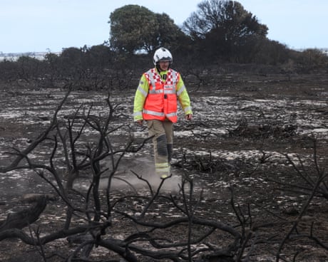
Wildfire near Sizewell nuclear plant causes ‘total devastation’ to Suffolk landscape

Emergency crews say situation remains ‘dynamic’ as more than 100 firefighters battle Dunwich Heath blaze

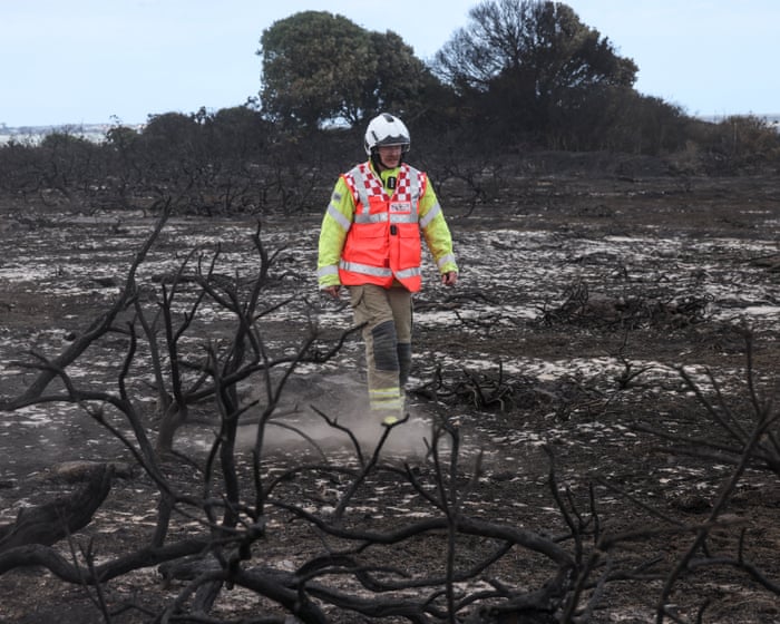
A wildfire near Britain’s biggest nuclear power station has caused “total devastation” to one of the UK’s most important landscapes, as fire crews said the situation remained “dynamic”.

More than 100 firefighters have been battling the blaze on Dunwich Heath, near Leiston, on the Suffolk coast since Wednesday evening. The fire service said on Friday afternoon the situation was stabilising but remained a “major incident” that was “dynamic and potentially changeable”.

Continue reading...

© Photograph: Humphrey Nemar/PA

© Photograph: Humphrey Nemar/PA

© Photograph: Humphrey Nemar/PA

  •  

Is Climate Change Supercharging El Niño?

As a new, potentially record-breaking El Niño begins, researchers are vigorously debating whether climate change is driving the phenomenon’s intensity.

© Ulet Ifansasti/Getty Images

Fighting a wildfire in South Sumatra, Indonesia, during an El Niño-exacerbated dry season in 2023.
  •  

Is Climate Change Supercharging El Niño?

As a new, potentially record-breaking El Niño begins, researchers are vigorously debating whether climate change is driving the phenomenon’s intensity.
  •  

Is Climate Change Supercharging El Niño?

As a new, potentially record-breaking El Niño begins, researchers are vigorously debating whether climate change is driving the phenomenon’s intensity.

© Ulet Ifansasti/Getty Images

Fighting a wildfire in South Sumatra, Indonesia, during an El Niño-exacerbated dry season in 2023.
  •  

Is Climate Change Supercharging El Niño?

As a new, potentially record-breaking El Niño begins, researchers are vigorously debating whether climate change is driving the phenomenon’s intensity.
  •  

Tensions Are Rising Among States That Rely on the Colorado River

A prolonged drought means the nation’s largest reservoirs are dwindling, and litigation over access to water could lie ahead.

© Nina Riggio for The New York Times

The Upper Colorado River on the Grand Canyon last month. About 40 million people and 5.5 million acres of cropland depend on the Colorado for drinking water and irrigation.
  •  
❌