❌

Reading view

1,000 Museum Visitors Dive Into NASA Sea Level Science on World Ocean Day

3 min read

1,000 Museum Visitors Dive Into NASA Sea Level Science on World Ocean Day
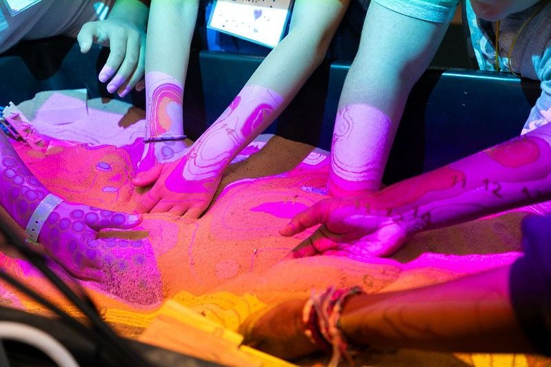
Several people place their hands and forearms on a brightly lit, abstract patterned surface under colorful fluorescent lighting.
Participants reach into an augmented reality sandbox, reshaping the terrain as projected contour lines and colors illustrate topographic features and elevation changes.
University of Georgia Marine Extension and Georgia Sea Grant

More than 1,000 visitors explored NASA sea level science firsthand during World Ocean Day at the University of Georgia Aquarium on Skidaway Island on June 6, 2026. The free event was supported by NASA’s Science Activation program through the Sea Level Education, Awareness, and Literacy (SEAL) project – a national effort that connects NASA sea level rise data with educators and coastal communities, particularly those historically underserved and already experiencing sea level impacts.

SEAL is a partnership between NASA and four NOAA Sea Grant programs working together to expand sea level rise understanding across U.S. coastal regions. By co-developing lesson plans, interactive activities, and place‑based learning experiences, SEAL helps educators engage learners with real NASA observations, models, and projections while strengthening community resilience to climate change.

During World Ocean Day, SEAL partners at Marine Extension and Georgia Sea Grant and the Coastal Equity and Resiliency Hub at Georgia Tech led hands‑on activities that brought sea level science to life. Visitors played the “Tumbling Tower” game, where removing blocks represents different community impacts from rising seas, and made “sea level friendship bracelets” that used colored glass beads to represent observed sea level rise along local coastlines.

The event also marked the debut of a new augmented reality sand box developed through SEAL. Guests shaped sand into coastal landscapes and watched NASA-informed sea level rise projections transform their creations in real time. Participants could experiment with resilience strategies, such as adding dunes or relocating homes, to see how adaptations might help communities prepare for future change.

Educators – formal, informal, home-based, and more – attending the event were able to take home four different SEAL lesson plans designed for both classrooms and informal learning settings. These materials help students explore sea level rise processes, modeling, variation, and impacts through NASA data and interactive STEM activities. SEAL aims to make all lesson plans developed through the project available online, but until then, please email Shannon Matzke to request digital copies.

“World Ocean Day is an annual tradition at the UGA Aquarium,” said Shannon Matzke, Marine Educator and Public Program Coordinator at UGA Marine Extension and Georgia Sea Grant. “With the support of NASA’s Science Activation program, this year’s event was free, which allowed us to reach more people and different audiences than we typically see. Incorporating SEAL activities made the day even more impactful for visitors – many of whom live in coastal communities already experiencing the effects of sea level rise.”

The SEAL project is supported by NASA cooperative agreement award number NNH21ZDA001N-SCIACT and is part of the NASA Science Activation Program portfolio, which connects learners with authentic NASA science experiences through partnerships with educators and community organizations.

  •  

Community College Instructors Bring Astronomy Textbook Into 21st Century

2 min read

Community College Instructors Bring Astronomy Textbook Into 21st Century

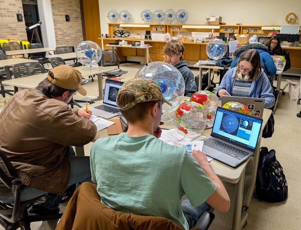
Classroom with seven students sitting at desks. They have their laptops open showing images of the celestial sphere. On the desks between the students are Earth globes and model celestial spheres.
Students studying the celestial sphere at Jackson College, Michigan.
Credit: Steven Tuckey

Teaching the beautiful and inspirational science of astronomy using only the conceptual framework offered by a traditional textbook – without incorporating the wealth of incredible resources, images and activities from NASA – falls short of the more modern, active learning experience that could better serve students evolving learning strategies. Three project teams from the NASA Science Activation (SciAct) program – NASA Community College Network (NCCN, led by the SETI Institute) and five of their expert community college instructors; Infiniscope (led by Arizona State University, ASU); and NASA Treks – set out to address this challenge. 

In June 2026, these teams gathered for a virtual workshop to lay the groundwork for incorporating active learning components drawn from NASA’s extensive education and visualization resource pool and the widely used but traditionally structured OpenStax Astronomy 101 textbook into Relevant Engaging Active Learning (REAL) courseware for introductory Astronomy, while preserving the core content and clear explanatory narrative of the text. 

Over the following two weeks, the instructors each adopted one of the opening five chapters of OpenStax, enhancing the content with active learning modules with an emphasis on materials developed by SciAct project teams, such as NASA Treks, Universe of Learning, and Cosmic Data Stories, to name a few. The results of their efforts were presented in a wrap-up presentation in July and will be field-tested in community college classrooms in Fall 2026.

This workshop served as a proof of concept for exploring whether an existing textbook can be effectively adapted into an active learning tool that will enhance students’ understanding of fundamental astronomical concepts. Next steps will include expanding the program and diving back into OpenStax to systematically reimagine the material into an active learning tool that covers the entire book – and therefore, the entire Universe! Importantly, this effort highlights new and highly impactful possibilities for the dissemination of NASA SciAct resources.

Special thanks to the five community college instructors and their invaluable wisdom, experience, and skills: Carver Bierson (Scottsdale Community College, Scottsdale Arizona), Dan Chase (Modesto Community College, Modesto, California), Dennis Just (Pima Community College, Pima, Arizona), Steve Tuckey (Jackson College, Jackson, Michigan) and Sally Watt (Glendale Community College, Glendale, Arizona).

NCCN, Infiniscope, NASA Treks, and many of the projects that contributed learning materials are supported by NASA cooperative agreement awards and are part of the NASA Science Activation Program portfolio, which connects learners with authentic NASA science experiences through partnerships with educators and community organizations.

Share

Details

Last Updated
Aug 10, 2026
Editor
NASA Science Editorial Team
  •  

Educators & Teens Get Hands-On With TEMPO Data to Help Investigate Local Air Quality

4 min read

Educators & Teens Get Hands-On With TEMPO Data to Help Investigate Local Air Quality

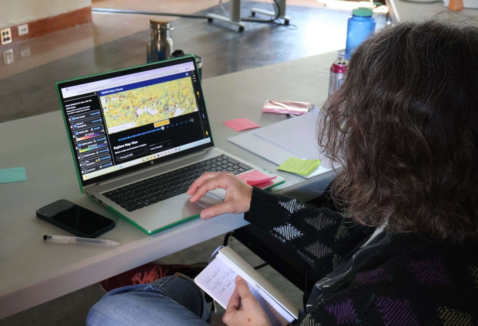
A workshop participant, seen from behind, sits at a laptop displaying the TEMPO-Lab Data Viewer. The screen shows a colorful satellite map of air quality data over the central United States, with toggleable data layers for NO2, HCHO, ozone, and fire detections listed on the left panel. The participant holds a small notebook and pen while working through the tool at a table scattered with sticky notes and water bottles.
An educator explores NASA’s TEMPO mission data using the CosmicDS TEMPO-Lab viewer during a hands-on immersion session at the BEST AQI Leadership Institute.
Credit: Devika Elakara

The NASA Science Activation Program’s Cosmic Storytelling with NASA Data (CosmicDS) project, led by Harvard University in Cambridge, Massachusetts, works to bring authentic NASA data into the hands of educators and learners. From July 27–29, 2026, the CosmicDS team partnered with the Smithsonian Institution’s BEST AQI (Breathing Easier: Supporting Teen Air Quality Investigations) project to host a Leadership Institute at the Center for Astrophysics | Harvard & Smithsonian (CfA) in Cambridge, MA. The Institute brought together 13 formal and informal educators who serve as advisors to BEST AQI, an initiative that guides teens through their own air quality research to support actions that improve air quality in their communities.

On Day 1 of the Institute, the CosmicDS Science Principal Investigator Pat Udomprasert led a hands-on immersion session introducing educators to TEMPO-Lab, a free online tool built with NASA Science Activation Program funding. TEMPO-Lab lets learners explore and analyze near-real-time air quality measurements collected by NASA’s TEMPO (Tropospheric Emissions: Monitoring of Pollution) mission, which measures pollution across North America hourly during daylight hours. During Days 2 and 3 of the Institute, as educators worked together to co-develop BEST AQI curriculum and resources, they used TEMPO-Lab to build case studies covering a variety of real-world air quality scenarios, including wildfire smoke and emissions from rush-hour traffic, power plants, and agriculture. These case studies will give the teens in their programs a strong foundation for investigating air quality where they live and deciding what actions they might take in their own communities.

One moment made the workshop especially memorable. During a science briefing, TEMPO scientist Heesung Chong shared that a new beta-version ground-level ozone data product had recently become available. TEMPO-Lab’s flexible design made it possible for CosmicDS software developer and educator John Lewis to integrate the new data product into the tool overnight, letting workshop participants explore cutting-edge ozone data themselves the very next morning. It was a striking example of how CosmicDS’s data tools can match the pace of active NASA science, giving educators and their learners access to data almost as soon as scientists themselves do.

“The BEST AQI Leadership Institute reinforced the value of the TEMPO-Lab as a tool for empowering youth to investigate local air quality issues using authentic NASA data. Educators were excited not only by the scientific capabilities of the platform, but by its potential to help young people use evidence to make informed decisions and contribute to positive change in their communities.”

— Erika Wright, Education Specialist, Smithsonian Astrophysical Observatory (SAO), and BEST AQI Principal Investigator

Equipping educators with both the technical skills and the curriculum to bring NASA air quality data into their classrooms matters because it builds data literacy skills that teens can carry into any career, while also giving them the tools to investigate issues that affect their health and their own communities. Air quality is a subject teens can see, smell, and feel the effects of — and BEST AQI is designed to help them turn that lived experience into evidence-based understanding and, ultimately, action.

The CosmicDS team will continue supporting these efforts in the year ahead. The 13 educators who attended this Leadership Institute plan to share the BEST AQI toolkit and TEMPO-Lab with approximately 100 additional educators across their partner sites in South Dakota, Maryland, and New York, potentially extending this work to thousands of teen air quality researchers.

Experience TEMPO-Lab at https://projects.cosmicds.cfa.harvard.edu/tempo-lab and learn more about the CosmicDS project at https://cosmicds.cfa.harvard.edu.

Cosmic DS is supported by NASA cooperative agreement award number 80NSSC21M0002 and is part of the NASA Science Activation Program portfolio, which connects learners with authentic NASA science experiences through partnerships with educators and community organizations.

Share

Details

Last Updated
Aug 07, 2026
Editor
NASA Science Editorial Team
  •  

Students Connect NASA Science With Indigenous Knowledge to Study Coastal Erosion

3 min read

Students Connect NASA Science With Indigenous Knowledge to Study Coastal Erosion

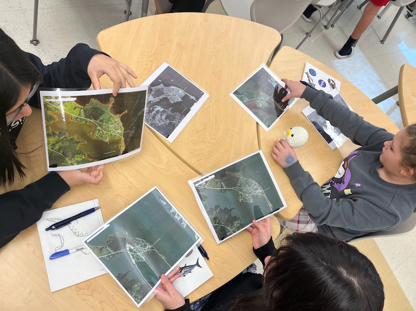
Three students sitting around a classroom table looking at NASA satellite images.
Students return from fieldwork and sit together in the classroom, examining NASA satellite images to learn about the changes to their community’s coastline.

Story by Keri Moskowitz, Gulf of Maine Research Institute

For the Pleasant Point Passamaquoddy Reservation, or Sipayik, the ocean has always been a teacher. Situated in what is known as Downeast Maine, along the shores of Passamaquoddy Bay, generations of Indigenous people have lived along the coast, learning from the tides, the land, and their elders. But today, the shoreline is changing more rapidly. Coastal erosion is slowly taking land away. Land that already holds a history of loss.

In the summer of 2023, inspired by a trip to Fairbanks, AK to attend Climate Change in My Community  – a workshop organized by the NASA Science Activation (SciAct) program’s Arctic and Earth Signs project – SciAct’s Learning Ecosystems Northeast (LENE) team began working with partners, including Indigenous leaders and scientists, to ask an important question: What does coastal erosion mean to people who have already lost land?

By November 2024, planning was underway at Sipayik Elementary School. The goal was to bring together Western science and Indigenous knowledge so students could understand the changes happening in their own community.

The lessons began in March 2025. For five weeks, nine 5th-grade students explored erosion in many ways. They visited local field sites and listened to elders share stories about how the coastline used to look. Learners used these accounts to measure the changes, both on the coast and via maps back in the classroom. They built erosion trays from simple materials to test how waves shape the land. They measured current high tide lines and compared them to historical ones. They studied old photographs and aerial images from 1942 to 2023 to see how much the shoreline had moved. They even compared 300-year-old tribal maps with future flood projections.

Students learned that science does not only live in textbooks. As one observer shared, “Our people were scientists without having to go to school.”

The students were curious, engaged, and proud. They saw that resilience is part of who they are. They have always adapted while holding on to culture. 

In June of 2026, the students were invited to the Gulf of Maine Research Institute to present their work to scientists, staff, and REU (Research Experience for Undergraduate) interns. They traveled 3.5 hours for this opportunity, and the journey proved worthwhile. During the Q&A portion following their slideshow, someone asked whether learning to read the various maps was difficult. One student responded with a reminder: these were not merely maps but NASA satellite images.

Future goals for the project include inviting more elders and adding more field sites in the work, strengthening language and cultural connections, sharing student learning with other Native youth, and planning resilience strategies like marsh restoration in coordination with tribal leadership. When the students were asked if they planned to continue their studies and work on this cause after their time in the classroom ended, they all resoundingly stated “YES”.

In Sipayik, the story of erosion is not just about land washing away. It is about memory, knowledge, identity, and the strength of a community that continues to learn from the shore.

Share

Details

Last Updated
Jul 08, 2026
Editor
NASA Science Editorial Team

Related Terms

  •  

GLOBE Mission Earth Educators Participate in Land Cover Community of Practice

3 min read

GLOBE Mission Earth Educators Participate in Land Cover Community of Practice

During the 2025-2026 school year, educators from the NASA Science Activation Program’s GLOBE (Global Learning and Observation to Benefit the Environment) Mission Earth project participated in a specialized Community of Practice led by NASA Langley Research Center to refine how students interact with NASA’s land cover data (MODIS, Landsat, and Sentinel-2). Their collaboration focused on four key areas:

  • Data Collection: Improving the process of making and submitting land cover observations to NASA using the GLOBE Observer App.
  • Curriculum Integration: Identifying connections between land cover observations, satellite data, and classroom learning.
  • Student Research: Brainstorming potential land cover research topics/questions for students.
  • Validation: Providing expert feedback on the satellite comparison process.

Through GLOBE, communities can contribute meaningful environmental data to a long-term data record. When participants make observations of land cover via GLOBE Observer, the team at NASA Langley compares their observation with satellite data for a similar time and location and sends a satellite comparison email, which includes a data table that shows how their GLOBE observation and the corresponding satellite data compare. 

Key Community of Practice Findings:
The Community of Practice included a total of 14 educators, with six actively collecting land cover observations with their students using the GLOBE Observer app. These land cover observations were collocated to MODIS, Landsat, and Sentinel-2 data with educators receiving a satellite comparison email. 

Within the scope of this Community of Practice, 10 of the educators developed student research plans for the 2026-2027 school year focused on land cover data, addressing questions such as:

  • How does land cover affect surface temperature?
  • How has land use changed over time for our local area?
  • How does land cover differ for locations (such as other schools) at the same latitude but different longitudes?
  • How do different land covers impact flooding?

The educators were extremely excited to have the opportunity to interact and learn from each other as a community, as well as to connect with NASA subject matter experts. Based on lessons learned from the Community of Practice, the team has a better understanding of how NASA land cover data can be incorporated in the classroom, what types of research questions educators might present to their students, and resources that could be developed to assist educators in the implementation of their research plans. 

Within the scope of the Land Cover Community of Practice (COP), educators were asked to provide feedback for the GLOBE Mission Earth GLOBE Nature Notes Guide that was developed by the NASA Langley team, leveraging the Nature Note model created by the NASA Science Activation program’s Learning Ecosystems North East (LENE) project, which is led by the Gulf of Maine Research Institute. The GLOBE Nature Notes aligned with GLOBE protocols were developed to assist educators in integrating the Nature Notes process with their students’ GLOBE observations. One of the COP educators is currently developing an example of a land cover GLOBE Nature Note that will be shared with the GLOBE and NASA Science Activation community, once completed.

Educators can join the GLOBE Program and contribute observations of Land Cover and other environmental conditions by downloading the GLOBE Observer app and learning more about Land Cover.

Screenshot of a NASA GLOBE Observer satellite comparison table emailed to a participant after submitting a land cover observation. The report includes the observation date and time, geographic coordinates, and surface condition details such as dry ground, leaves present, muddy conditions, and weather observations. A row of six participant photos labeled North, East, South, West, Up, and Down shows the surrounding environment near a waterfront with buildings, pavement, sky, and water visible. Below the photos is a land cover classification section with a color-coded map comparing the participant’s observation area to MODIS satellite land cover data. A legend identifies categories including water bodies, forests, wetlands, croplands, urban and built-up lands, and barren areas. The classification for this observation is listed as “Urban and Built-up Lands.” At the bottom of the report, side-by-side satellite images from Landsat 8 & 9 and Sentinel-2A and 2B display the same geographic area from orbit. The document demonstrates how NASA Langley’s GLOBE Mission Earth Science Activation project compares community-submitted land cover observations with satellite imagery and land classification datasets.
Sample of a NASA GLOBE Observer satellite comparison table that gets emailed to a participant after submitting a land cover observation. (NASA Langley GLOBE Mission Earth Science Activation project team).
NASA GLOBE Observer

GLOBE Mission Earth is supported by NASA under cooperative agreement award number NNX16AC54A and is part of NASA’s Science Activation Portfolio. Learn more about how Science Activation connects NASA science experts, real content, and experiences with community leaders to do science in ways that activate minds and promote deeper understanding of our world and beyond: https://science.nasa.gov/learn/about-science-activation/.

Share

Details

Last Updated
Jun 10, 2026

The post GLOBE Mission Earth Educators Participate in Land Cover Community of Practice appeared first on NASA Science.

  •  

GLOBE Mission Earth Educators Participate in Land Cover Community of Practice

3 min read

GLOBE Mission Earth Educators Participate in Land Cover Community of Practice

During the 2025-2026 school year, educators from the NASA Science Activation Program’s GLOBE (Global Learning and Observation to Benefit the Environment) Mission Earth project participated in a specialized Community of Practice led by NASA Langley Research Center to refine how students interact with NASA’s land cover data (MODIS, Landsat, and Sentinel-2). Their collaboration focused on four key areas:

  • Data Collection: Improving the process of making and submitting land cover observations to NASA using the GLOBE Observer App.
  • Curriculum Integration: Identifying connections between land cover observations, satellite data, and classroom learning.
  • Student Research: Brainstorming potential land cover research topics/questions for students.
  • Validation: Providing expert feedback on the satellite comparison process.

Through GLOBE, communities can contribute meaningful environmental data to a long-term data record. When participants make observations of land cover via GLOBE Observer, the team at NASA Langley compares their observation with satellite data for a similar time and location and sends a satellite comparison email, which includes a data table that shows how their GLOBE observation and the corresponding satellite data compare. 

Key Community of Practice Findings:
The Community of Practice included a total of 14 educators, with six actively collecting land cover observations with their students using the GLOBE Observer app. These land cover observations were collocated to MODIS, Landsat, and Sentinel-2 data with educators receiving a satellite comparison email. 

Within the scope of this Community of Practice, 10 of the educators developed student research plans for the 2026-2027 school year focused on land cover data, addressing questions such as:

  • How does land cover affect surface temperature?
  • How has land use changed over time for our local area?
  • How does land cover differ for locations (such as other schools) at the same latitude but different longitudes?
  • How do different land covers impact flooding?

The educators were extremely excited to have the opportunity to interact and learn from each other as a community, as well as to connect with NASA subject matter experts. Based on lessons learned from the Community of Practice, the team has a better understanding of how NASA land cover data can be incorporated in the classroom, what types of research questions educators might present to their students, and resources that could be developed to assist educators in the implementation of their research plans. 

Within the scope of the Land Cover Community of Practice (COP), educators were asked to provide feedback for the GLOBE Mission Earth GLOBE Nature Notes Guide that was developed by the NASA Langley team, leveraging the Nature Note model created by the NASA Science Activation program’s Learning Ecosystems North East (LENE) project, which is led by the Gulf of Maine Research Institute. The GLOBE Nature Notes aligned with GLOBE protocols were developed to assist educators in integrating the Nature Notes process with their students’ GLOBE observations. One of the COP educators is currently developing an example of a land cover GLOBE Nature Note that will be shared with the GLOBE and NASA Science Activation community, once completed.

Educators can join the GLOBE Program and contribute observations of Land Cover and other environmental conditions by downloading the GLOBE Observer app and learning more about Land Cover.

Screenshot of a NASA GLOBE Observer satellite comparison table emailed to a participant after submitting a land cover observation. The report includes the observation date and time, geographic coordinates, and surface condition details such as dry ground, leaves present, muddy conditions, and weather observations. A row of six participant photos labeled North, East, South, West, Up, and Down shows the surrounding environment near a waterfront with buildings, pavement, sky, and water visible. Below the photos is a land cover classification section with a color-coded map comparing the participant’s observation area to MODIS satellite land cover data. A legend identifies categories including water bodies, forests, wetlands, croplands, urban and built-up lands, and barren areas. The classification for this observation is listed as “Urban and Built-up Lands.” At the bottom of the report, side-by-side satellite images from Landsat 8 & 9 and Sentinel-2A and 2B display the same geographic area from orbit. The document demonstrates how NASA Langley’s GLOBE Mission Earth Science Activation project compares community-submitted land cover observations with satellite imagery and land classification datasets.
Sample of a NASA GLOBE Observer satellite comparison table that gets emailed to a participant after submitting a land cover observation. (NASA Langley GLOBE Mission Earth Science Activation project team).
NASA GLOBE Observer

GLOBE Mission Earth is supported by NASA under cooperative agreement award number NNX16AC54A and is part of NASA’s Science Activation Portfolio. Learn more about how Science Activation connects NASA science experts, real content, and experiences with community leaders to do science in ways that activate minds and promote deeper understanding of our world and beyond: https://science.nasa.gov/learn/about-science-activation/.

Share

Details

Last Updated
Jun 10, 2026
  •  
❌