❌

Normal view

Anak Krakatau Rumbles Again

9 September 2026 at 05:01
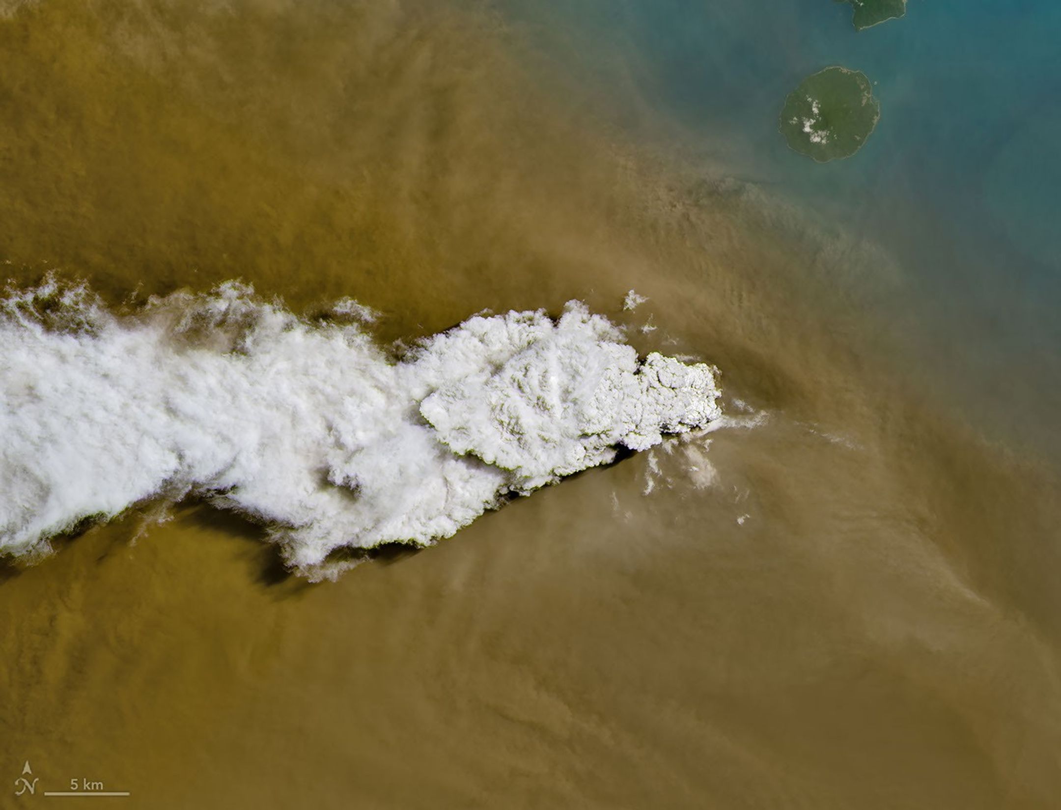
A white volcanic plume streams left over a tan ash cloud that fills most of the image. A small green island and blue water are visible in the upper right.
Anak Krakatau erupts ash and volcanic gases in this image acquired with the OLI (Operational Land Imager) on Landsat 8 on September 5, 2026.
NASA Earth Observatory/Michala Garrison

Eruptions are a regular occurrence at Anak Krakatau, a small volcano between the Indonesian islands of Java and Sumatra. Much of its activity remains relatively mild, but it occasionally puts on more impressive and hazardous shows of force. In early September 2026, a booming eruption lasting more than 24 hours sent gas and ash high into the atmosphere, disrupting thousands of flights and degrading air quality in parts of the country, including the capital city of Jakarta.

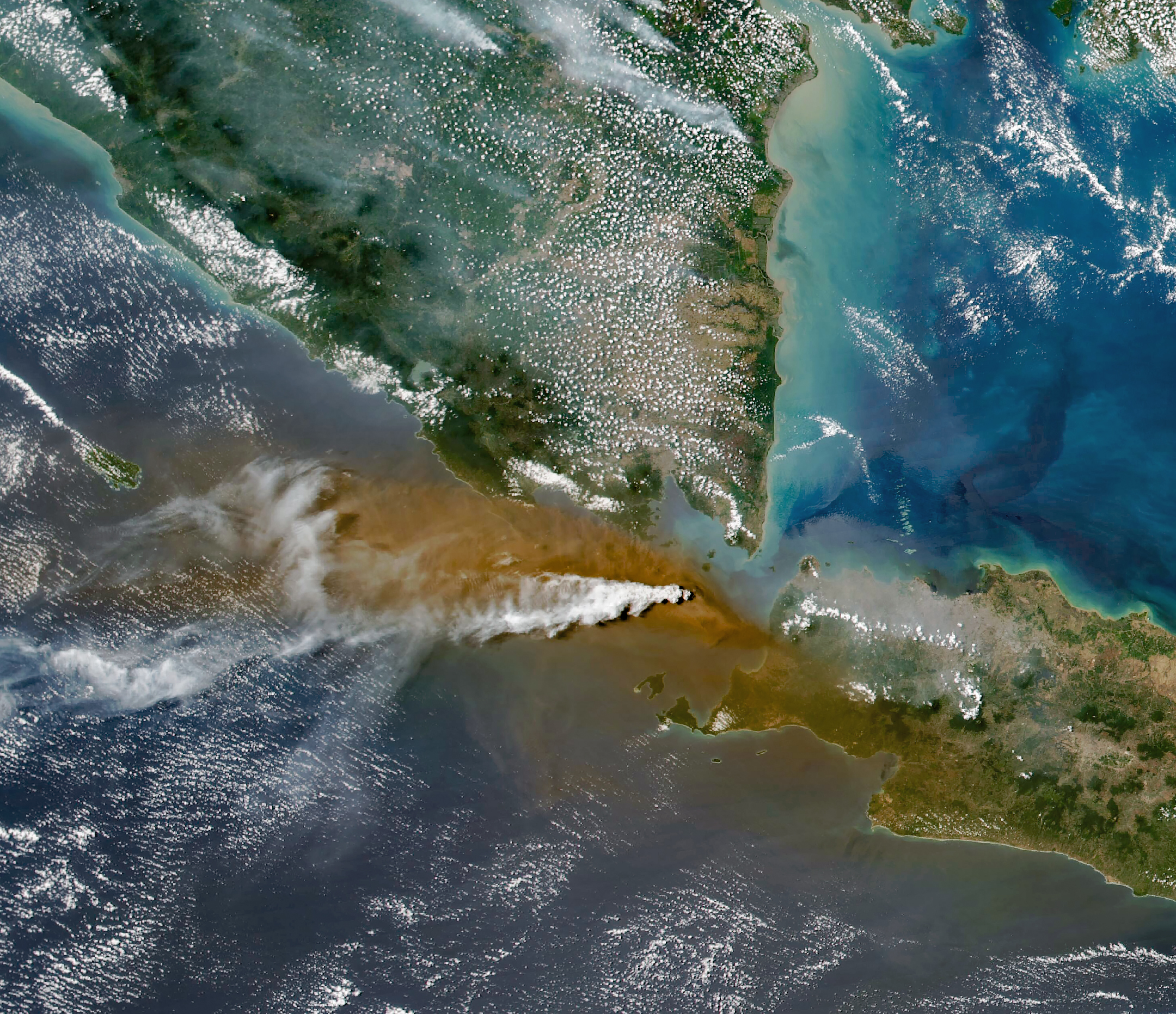
Satellites passing over the area during the eruption on September 5 captured images of the explosive activity. In the scene above, acquired with the OLI (Operational Land Imager) on the NASA-USGS Landsat 8 satellite, a white plume of volcanic gas billows over a brown ash cloud. Below, a wider view captured by the VIIRS (Visible Infrared Imaging Radiometer Suite) on the Suomi NPP satellite shows the volcanic material dispersing over a large area.

Indonesia’s meteorological agency reported that ash had reached altitudes up to 6,000 meters (20,000 feet) to the east of the volcano and 15,000 meters (50,000 feet) to the west by September 6. The presence of ash in the atmosphere prompted the temporary closure of eight airports on Java and Sumatra, disrupting nearly 3,000 flights in and out of the area, according to news reports.
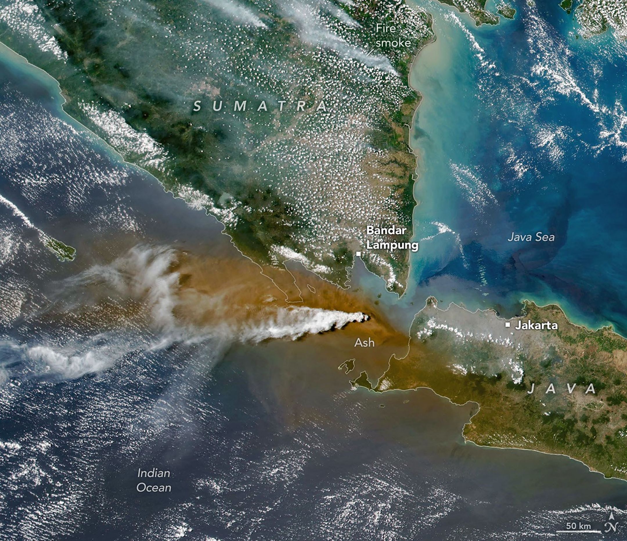
A white plume streams to the left over a larger tan ash cloud, both coming from a volcanic eruption between the Indonesian islands of Java and Sumatra.
Plumes of ash and volcanic gases from Anak Krakatau drift over Indonesia and the Indian Ocean in this image captured by the VIIRS (Visible Infrared Imaging Radiometer Suite) on the Suomi NPP satellite on September 5, 2026.
NASA Earth Observatory/Michala Garrison

Ashfall affected populated areas, particularly to the east of Anak Krakatau in Jakarta and other parts of West Java, the Indonesian Humanitarian Coordination Platform (IHCP) reported. Volcanic ash poses health risks to people and can irritate the respiratory tract, eyes, and skin. However, this air quality hazard differs from the smoke produced by peatland fires elsewhere in the country in terms of particle characteristics, dispersal patterns, and protection measures, the IHCP noted. 

On September 6, the continuous explosive eruption from Anak Krakatau subsided, though the volcano kept rumbling. It returned to a more typical pattern of Strombolian eruptions, characterized by intermittent spurts of ash and volcanic material. Airports had resumed operation by September 8, but the volcano remained at the second-highest alert level on the country’s scale, as it has been since early July.

NASA Earth Observatory images by Michala Garrison, using Landsat data from the U.S. Geological Survey, and VIIRS data from NASA EOSDIS LANCE, GIBS/Worldview, and the Suomi National Polar-orbiting Partnership. Story by Lindsey Doermann.

Downloads

A white volcanic plume streams left over a tan ash cloud that fills most of the image. A small green island and blue water are visible in the upper right.

September 5, 2026: Landsat

JPEG (14.89 MB)

A white plume streams to the left over a larger tan ash cloud, both coming from a volcanic eruption between the Indonesian islands of Java and Sumatra.

September 5, 2026: VIIRS

JPEG (3.38 MB)

References & Resources

You may also be interested in:

Stay up-to-date with the latest content from NASA as we explore the universe and discover more about our home planet.

Ever Restless Mount Dukono Erupts

2 min read

The volcano on Indonesia’s Halmahera Island routinely ejects ash, volcanic gases, and volcanic bombs.

Article

New Eruption in the Bismarck Sea

5 min read

Satellite imagery shows a surge of new volcanic activity in the ocean near Papua New Guinea.

Article

Melting Snow Off Shivelyuch

4 min read

Near-constant activity continues on the volcano in Russia.

Article

An ancient 'supervolcano' has been found hiding beneath eastern England. But experts say there's not enough evidence to call it that.

Scientists have identified an ancient volcano on England's east coast that is so eroded, it took researchers three decades to piece together its enormous size and explosive past. What remains of the caldera system is located beneath the English counties of Norfolk and Lincolnshire.

However, while the volcano undoubtedly produced at least one huge-scale eruption, some experts don't think there is enough evidence for the structure to be called a supervolcano.

"It obviously must have been a very large eruption, but it would be very difficult to calculate the volume of the eruption given the poor preservation of the deposits," said Michael Poland, a research geophysicist with the Cascades Volcano Observatory and the scientist-in-charge of the Yellowstone Volcano Observatory. "This is part of the reason I really hate the term 'supervolcano,'" Poland, who was not involved in the discovery, told Live Science in an email.

In a recent analysis, published April 29 in the Geological Society of America Bulletin, scientists examined zircon crystals that were taken 80 years ago from boreholes 40 miles (65 kilometers) apart in Norfolk and Lincolnshire. Zircon crystals are smaller than the diameter of a human hair and form within molten magma underground before a volcano erupts. They contain uranium that decays into lead isotopes at a known rate, enabling researchers to precisely date eruptions.

The results showed an age match between the zircon crystals from Norfolk and Lincolnshire and counterparts taken from the Kinnekulle tephra, a thick layer of volcanic ash covering Scandinavia and the Baltic region. This suggests the ash plume from the volcano in what is now eastern England blew across the Tornquist Sea, a body of water that existed during the Ordovician period (488.3 million to 443.7 million years ago), and settled on what is now Scandinavia.

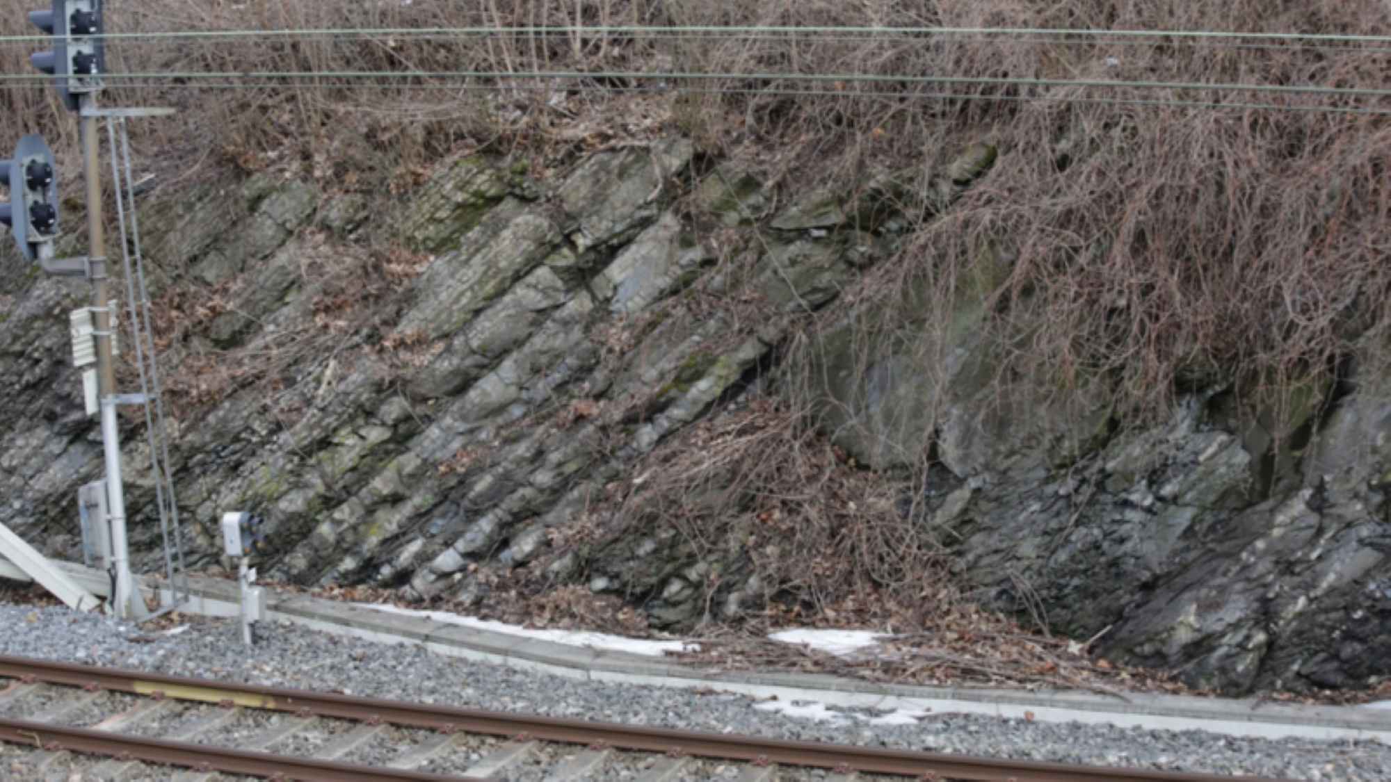
Evidence of the ancient volcanic ash near train tracks in Norway.

The Kinnekulle tephra is visible next to train track north of Oslo in Norway. Dipping strata of the Arnestad Formation (Late Ordovician) contain thin beds of gray-green altered volcanic ash. (Image credit: © Tim Pharaoh)

Researchers already knew that the Kinnekulle tephra was formed during a massive volcanic eruption. But the recent analysis shows for the first time how far the ash traveled and, therefore, how big the eruption really was.

The eruption would have also produced huge pyroclastic flows, or avalanches of rocky debris, ash and hot gas that race down the sides of some erupting volcanoes, said Peter Rowley, a volcanologist and senior lecturer at the University of Bristol in the U.K. who was not involved in the analysis. "The last eruption of this kind of scale was the Oranui event at Taupō in New Zealand, over 26,000 years ago," he told Live Science in an email.

However, while the explosion would have been impressive and equivalent to the force of thousands of atomic bombs, experts said the definition of a supervolcano is vague and there are better ways to describe what happened.

"The scientific definition of a supervolcano varies a little; it’s a term we tend not to use as volcanologists much," Rowley said. "In this case we would describe it as an ultraplinian eruption."

Ultraplinian eruptions are the most violent type of volcanic explosions, ejecting more than 240 cubic miles (1,000 cubic kilometers) of material. It's difficult to say exactly what the eruption that formed the Kinnekulle tephra would have looked like, but it likely lasted days to weeks and formed ash clouds taller than 25 miles (40 km) that reached into the stratosphere.

Geologists tend to reject the term supervolcano because it is imprecise, instead preferring to describe eruptions by the volume of material they eject.

Stephen Self, a physical volcanologist at the University of California, Berkeley, agreed that the term supervolcano can be too vague. "Supervolcano has become a kind-of buzz-word," he told Live Science in an email. "It's the deposits of the eruptions that are recognized, not the volcano."

Very little of the material ejected in England's ultraplinian eruption remains today, because most of it was eroded or buried. "The geological record is far from complete so it can be very difficult to say much about these eruption volumes with very old volcanoes," Rowley said.

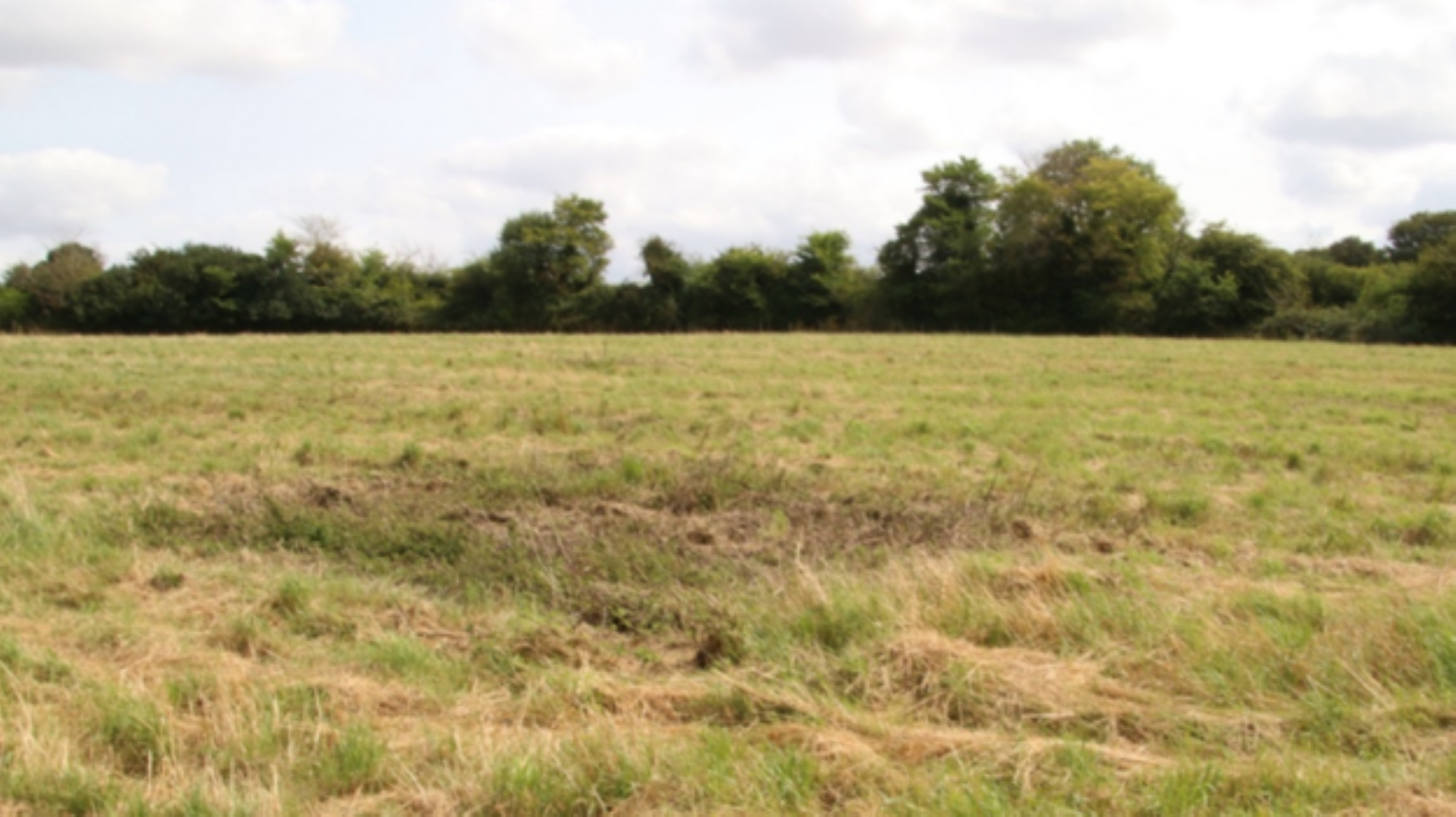
A field in England where scientists drilled boreholes into an ancient volcano.

The location of one of the borehole samples studied, at North Creake in Norfolk. (Image credit: © Tim Pharaoh)

Similarly, the Kinnekulle tephra has been degraded over time, Poland said.

The analysis also found evidence for an earlier eruption of the volcano that occurred 453.7 million years ago. However, there is no trace of these eruptions at the surface today; the boreholes are located in some of England's flattest landscapes, study first author Tim Pharaoh, a geophysicist with the British Geological Survey, said in a statement in August.

It's not surprising to find traces of big, ancient volcanoes in England. The recently identified volcano is part of a wider volcanic system that was active 450 million years ago and includes Eryri National Park in Wales and the Lake District in northwestern England, Rowley said.

"It's best not to imagine whole preserved volcanoes, but rather that we have deposits from their eruptions, or rocks which formed in the magma reservoirs beneath the original volcano," Rowley said. "These are often deformed and altered by tectonic events meaning that it takes some careful geological investigation to interpret the true picture."

❌