❌

Normal view

A Texas-size chunk of winter sea ice is missing from Antarctica β€” and it's probably not coming back

16 June 2026 at 17:39

A colossal chunk of sea ice roughly the size of Texas is missing from the west coast of Antarctica, and scientists fear it might never form again.

Antarctica is currently in winter, which runs from March to October on the southernmost continent. During the winter months, floating sea ice surrounding the continent typically grows, driving currents that regulate Earth's climate. But this year, there's a notable ice gap over the Bellingshausen Sea, on the western side of the Antarctic Peninsula.

Satellite observations have revealed that around 250,000 square miles (650,000 square kilometers) of sea ice hasn't formed yet, compared with the average amount of sea ice between 1991 and 2020, The Guardian reported last week. For comparison, the ice gap covers an area slightly larger than France or nearly the size of Texas.

Will Hobbs, a sea ice-ocean interaction scientist at the University of Tasmania, told The Guardian that he was "concerned" by the lack of sea ice and that it was "depressing." Hobbs noted that this year represents the third time in four years that the region's sea has been very low.

"I don't think we will see sea ice there any more," he said. "It's done."

Researchers still have a lot to learn about sea ice changes in Antarctica. Hobbs said that the sea ice loss was likely linked to changes in the ocean and that scientists are trying to determine whether global warming was a factor.

Sea ice has declined much more slowly in Antarctica than in the Arctic. But in recent years, scientists have been witnessing an astonishing change in the sea ice extent. One record low in 2016 was followed by another in 2022 and then a third in 2023.

Edward Doddridge, a physical oceanographer at the Institute for Marine and Antarctic Studies in Australia, told ABC News (Australia) that he was no longer surprised by sea ice loss.

"It's not good news, but it has become a pattern that we're expecting now," Doddridge said. "A warming world is going to have less sea ice."

The diminished winter sea ice is likely to have a variety of knock-on effects. For example, this area of sea ice normally provides important habitat for animals like krill and penguins. Sea ice also plays an important role in regulating the climate, including by driving key ocean currents, insulating the ocean from the sun, and protecting ice shelves at the mouths of glaciers.

Down the coast from the missing sea ice, researchers have warned that a key ice shelf is about to disintegrate from Antarctica's Thwaites Glacier β€” nicknamed the "Doomsday Glacier" because its collapse could raise sea levels by 2.1 feet (65 centimeters) in the coming centuries, flooding coastal communities worldwide. The ice shelf helps protect the mouth of the glacier by acting as a buttress, thereby restraining the flow of ice from the glacier into the sea.

Thwaites Glacier has been melting rapidly since the 1980s, which is part of a wider concern for the West Antarctic Ice Sheet that it helps to support. The collapse of such an ice sheet is considered one of the major environmental tipping points, or "points of no return," that humanity must avoid in the fight to rein in climate change.

'The system is critically stressed': San Andreas and San Jacinto faults scarily close to major earthquake, study finds

The San Andreas and San Jacinto fault systems are at their highest levels of tectonic stress in 1,000 years, raising the threat of a major, imminent earthquake that could devastate Southern California, a new study finds.

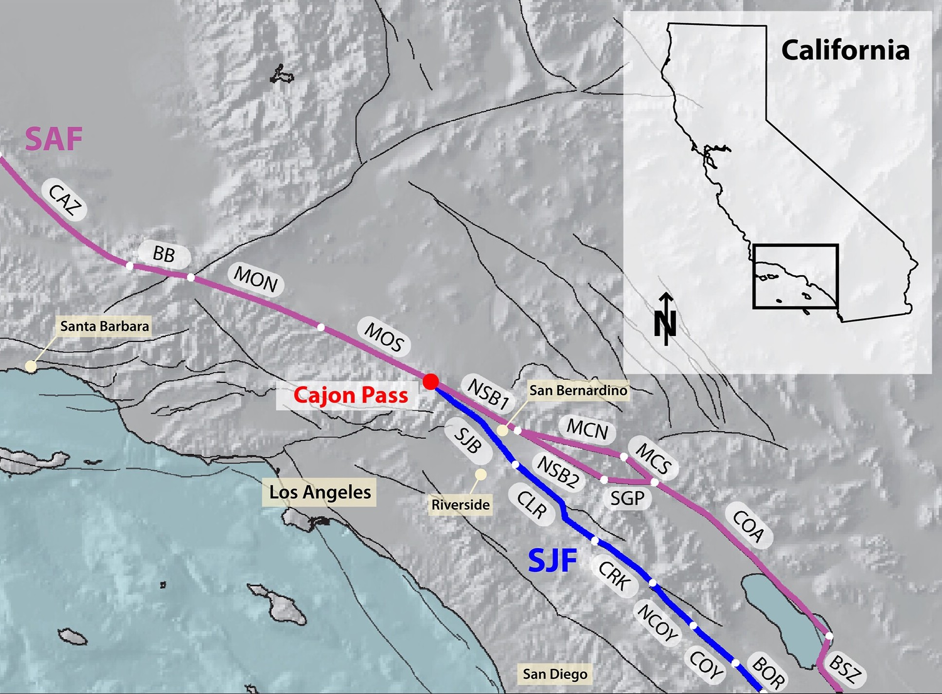
The faults could rupture separately or together, thanks to an "earthquake gate" between them at Cajon Pass, where the San Jacinto fault splits from the main trace of the San Andreas fault. Researchers discovered that Cajon Pass can prevent or facilitate earthquakes moving between the faults, depending on how similar their stress levels are at the time of rupture.

And right now, the San Andreas and San Jacinto faults appear to have comparable, extremely elevated stress levels, potentially spelling trouble for Los Angeles, San Bernardino, Riverside and the Coachella Valley, the team warned.

Map of Southern California showing the San Andreas and San Jacinto fault systems. The faults connect at Cajon Pass and run parallel to each other.

Cajon Pass, where the San Andreas and San Jacinto faults connect, is an "earthquake gate" that can facilitate the spread of ruptures. (Image credit: Burkhard et al., 2026. JCR Solid Earth. (CC BY 4.0))

"Our results show that stress levels on multiple fault segments are now at or above the highest values seen in the past millennium and that the region may be capable of a large through-going rupture involving both fault systems," study first author Liliane Burkhard, a planetary geologist at the University of Bern in Switzerland and at the University of Hawaii at Manoa, said in a statement.

The San Andreas and San Jacinto faults have caused 36 earthquakes with magnitudes of 6.4 or above in the past 1,000 years. Southern California's last "big one" was a magnitude 7.9 event in 1857, when a 205-mile (330 kilometers) segment of the San Andreas fault slipped horizontally between Parkfield and Cajon Pass. That rupture did not propagate through Cajon Pass, but a similar megaquake in 1812 did, suggesting this could happen again in what is now a much more built-up and densely populated environment, according to the study.

Almost 170 years have passed since the 1857 megaquake, raising fears that another huge earthquake could be due to hit soon.

To estimate this risk, Burkhard and her colleagues built a model replicating the last 1,000 years of major earthquake activity along the southern San Andreas and San Jacinto fault systems.

The researchers used observations such as tree-ring records and age data from sediments that have been displaced to reconstruct Southern California's earthquake history. They fed this information into the model, which simulated the accumulation, release and propagation of tectonic stress in the San Andreas and San Jacinto faults.

The results, published June 3 in the Journal of Geophysical Research: Solid Earth, suggest the San Andreas and San Jacinto faults are primed for an Earth-shattering rupture, which may involve the earthquake gate at Cajon Pass opening to unleash more destruction than a single-fault event would on its own.

If a rupture were to occur along the two branches of the San Andreas fault that connect at Cajon Pass, it would be a joint rupture, according to the study. If both branches of the San Andreas fault and the San Jacinto fault were involved, this would constitute a tripartite rupture.

The chance of each event happening and the timing of a potential rupture are unknown, but understanding how much stress is building up inside the system could help planners and policymakers prepare for whatever comes next, Burkhard said.

"What we can say is that the system is critically stressed, and that physics-based models like this one give us a clearer picture of the range of scenarios we should be prepared for," she said. "That information matters for hazard assessment, infrastructure planning, and emergency preparedness."

The researchers say their model could apply to other fault junctions and be used as a tool for hazard assessment globally. "We are using rigorous, quantitative science to better understand the risk facing millions of people," Burkhard said.

Indonesia's near-identical, 'Twin Peaks' volcanoes form striking mirror image β€” Earth from space

16 June 2026 at 14:39
QUICK FACTS

Where is it? Central Java, Indonesia [-7.34485373, 110.02748950]

What's in the photo? Mount Sundoro (left) and Mount Sumbing (right)

Who took the photo? An unnamed astronaut on board the International Space Station

When was it taken? May 10, 2021

This awesome astronaut photo shows the striking symmetry of "twin" stratovolcanoes at the heart of Java, Indonesia. The parallel peaks are an eye-catching reminder of the region's extreme tectonic activity.

Mount Sundoro (also known as Sindoro or Sindara) on the left of the image, reaches a maximum height of 10,331 feet (3,149 meters). Its partner, Mount Sumbing, sits to the southeast (on the right of the image) and is slightly taller, at 11,056 feet (3,370 m) above sea level.

Both are considered active. Although Sumbing has not erupted since 1730, Sundoro has blown its top more recently, in 1971, and has experienced seismic activity as recently as 2012, according to the Smithsonian Institution's Global Volcanism Program.

The volcanoes' peaks are just 7.5 miles (12 kilometers) apart. A raised ridge with a major highway runs perpendicularly between them.

Each volcano also has a smaller, secondary cone on its flank left over from previous eruptions (to the upper left of Sundoro and the upper right of Sumbing in the image), and their orientations make the volcanoes look like mirror images of each other.

An aerial photograph showing Sundoro and Sumbing side-by-side with near-identical profiles

The two volcanoes also have strikingly similar profiles when viewed from ground level. (Image credit: Rizky Panuntun via Getty Images)

The slopes of both cones are covered with rings of dark-green forest that sharply terminate at their bases. The volcanic soils surrounding the mountains are excellent for growing crops such as rice, corn, coffee and sugarcane, which has led to the deforestation of their surroundings, according to NASA's Earth Observatory.

This matching coloration accentuates the similarities between the pair, especially when viewed from above.

One of the few differences between Sundoro and Sumbing is that the latter volcano has a sizable crater at its summit, which was carved out by the 1730 eruption. As a result, the larger volcano appears to have a darker point at its top.

The volcanoes are commonly referred to as "twins," due to their near-identical profiles. However, local people often call them "husband and wife," according to a local travel site. In this narrative, Sumbing is considered the husband due to its slight height advantage and "more masculine" profile.

A photo of Mount Sumbing showing farmers using the fields around its base

The land surrounding Mount Sundoro and Mount Sumbing (photographed) is rich with volcanic ash, making it ideal for growing various crops. (Image credit: Wikimedia)

Sundoro and Sumbing are part of the wider Dieng Volcanic Complex, which consists of around 20 volcanic cones stretching across central Java. Indonesia is also positioned along the "Ring of Fire," a roughly horseshoe-shaped arc of volcanoes that runs along a series of tectonic plate boundaries encircling the Pacific Ocean.

Over the past few years, there have been a number of significant eruptions in Indonesia, including a pair of violent blasts at Mount Lewotobi Laki-laki, on Flores Island, in 2024 and 2025. As of June 2026, there are seven ongoing eruptions in Indonesia β€” the most of any nation.

An astronaut photo of the massifRocky rings wear a 'magma hat'

A 2025 astronaut photo shows a massif made of concentric mountain ridges in the Libyan desert. The rocky walls contain ancient artworks.

An astronaut photo of three dark mesas, partially surrounded by orange sand dunesTrio of black mesas in Sahara

A 2023 astronaut photo shows three dark hills, or mesas, towering above southern Mauritania. The structures are remnants of a single Paleozoic-era formation.

An astronaut photo of a volcanic caldera with a skull like shapeGlowering 'skull' in volcanic pit

A 2023 astronaut photo shows off an unusual cranium-like structure appearing to stare up into space from the floor of a large volcanic caldera in Chad.

❌