Un étage supérieur de Falcon 9 s'est retrouvé sur une trajectoire de collision avec la Lune. Si nous n’avons aucune image du moment de l’impact, un satellite coréen a pu prendre les premières images du cratère.
Depuis vingt-cinq ans, Futura raconte les grandes avancées scientifiques qui changent notre compréhension du monde. Parmi elles, une mission spatiale discrète a profondément transformé les sciences de la Terre. En « pesant » notre Planète depuis l'espace, les satellites Grace ont apporté dès...
HELSINKI — China sent a new pair of secretive satellites into a programmatically new orbit Wednesday, while also upgrading its on-orbit communications relay capabilities. A Long March 6A rocket lifted […]
En Gironde et dans les Landes, un feu né à Saumos a déjà dévoré plus de 42 000 hectares. Il a dépassé le bassin d’Arcachon et léché la métropole bordelaise. Ces quelques images replacent ces feux de 2026 dans l’histoire récente de la France… et face aux mégafeux qui pulvérisent nos records.
Un internaute a découvert qu’un satellite de télécommunication Starlink de SpaceX est passé devant un satellite d’imagerie de la surface Terre pendant qu’il survolait le Texas. L’image a été retrouvée sur Google Earth. Que nous dit cet événement pas si anodin que cela ?
Emergency SOS via satellite is now available in Andorra and Iceland, allowing supported iPhone and Apple Watch users to contact emergency services when cellular and Wi-Fi coverage are unavailable.
Apple added both countries to an updated support document, expanding the feature to 20 supported markets. Users in Andorra and Iceland can call or text 112 before choosing the satellite option when an ordinary emergency connection cannot be completed.
The expansion covers every iPhone 14 or later model running iOS 26.4 or newer. Apple Watch access requires Apple Watch Ultra 3 with watchOS 26.4 or later.
Emergency SOS does not turn the devices into conventional satellite phones. The system is designed for short emergency exchanges in locations where normal communication networks cannot be reached. Users must remain outdoors with a sufficiently clear view of the sky and follow onscreen directions while the device establishes and maintains a connection.
Emergency SOS via Satellite Reaches 20 Markets
Emergency SOS via satellite first launched in the United States and Canada in November 2022 with the iPhone 14 lineup. Apple gradually added European countries, Australia, New Zealand, Japan and Mexico as regulatory approval and emergency-service support became available.
Andorra and Iceland now join Australia, Austria, Belgium, Canada, France, Germany, Ireland, Italy, Japan, Luxembourg, Mexico, the Netherlands, New Zealand, Portugal, Spain, Switzerland, the United Kingdom and the United States.
The addition is particularly relevant for travelers and residents exploring mountainous or remote terrain.
Andorra contains extensive hiking, cycling and skiing areas across the Pyrenees, where cellular coverage can become unreliable beyond populated valleys and resorts. Iceland presents a different but equally demanding environment, with large rural areas, volcanic landscapes, glaciers and routes far from conventional infrastructure.
Satellite availability does not guarantee a connection everywhere. Mountains, deep valleys, dense tree cover and tall structures can obstruct the line between the device and a passing satellite. Apple also warns that satellite connectivity may not function in locations above 62 degrees latitude, which can affect some northern regions.
Most of Iceland lies below that threshold, although environmental conditions and the position of surrounding terrain can still influence performance.
International travelers can generally use Emergency SOS while visiting a supported country, even when the feature is not offered in their home market. Exceptions apply to devices purchased in certain countries or regions where Apple satellite connectivity is restricted.
iPhone 14 and Newer Models Gain the Expansion
Every version of iPhone 14 and later contains the hardware required for Apple satellite features. Users in Andorra and Iceland must install iOS 26.4 or a newer release before relying on Emergency SOS.
The system appears only when the iPhone cannot reach cellular service or Wi-Fi. Apple recommends trying the local emergency number first because another carrier network may still be able to complete the call even when the user own provider shows no coverage.
When the call fails, the iPhone offers Emergency Text via Satellite. The user answers a short series of questions describing the emergency, including the type of assistance needed and whether anyone is injured.
The compressed questionnaire reduces the amount of information that must be transmitted through the limited-bandwidth satellite connection. Once connected, the iPhone sends the responses and location to an emergency dispatcher or an Apple-supported relay center capable of contacting local responders.
In Andorra and Iceland, the applicable emergency number is 112.
Users can also choose to notify emergency contacts. When Medical ID and emergency contacts have been configured in the Health app, selected details can be shared during the incident.
The conversation does not operate at the speed of an ordinary text exchange. Under ideal conditions, a message may require approximately 30 seconds to send. Light or moderate foliage can extend that delay beyond one minute, while heavier obstructions may prevent a connection entirely.
The iPhone displays guidance showing which direction to turn or move as satellites pass overhead. The phone can remain connected while the screen is locked, but it should not be placed inside a pocket or backpack during the exchange.
Apple Watch Ultra 3 Works Without an iPhone Nearby
Apple Watch Ultra 3 brings similar protection directly to the wrist, allowing users to contact emergency services even when an iPhone is not available.
Emergency SOS via satellite on Apple Watch Ultra 3 does not require an active carrier plan. Apple includes the service at no additional charge for two years following activation of the watch.
When cellular and Wi-Fi connections are unavailable, users can attempt an emergency call or open Messages and text 112. If the message cannot be delivered through an ordinary network, the watch presents the satellite emergency option.
Apple Watch Ultra 3 also guides the wearer toward the satellite connection. The device can remain in its normal position on the wrist rather than being held above the head, although the user may be instructed to turn or move away from an obstruction.
A wet watch may have more difficulty maintaining satellite communication, an important limitation for swimmers, boaters and users caught in severe weather.
The watch can send the emergency questionnaire, location, elevation, Medical ID information and battery level. Emergency contacts can also receive information about the incident when the user has enabled that option beforehand.
Crash Detection and Fall Detection add another layer. If iPhone 14 or later or Apple Watch Ultra 3 detects a severe crash or hard fall and the user remains unresponsive, the emergency notification may be transmitted over satellite when cellular and Wi-Fi networks are unavailable.
Image Credit: Apple Inc.
Preparation Matters Before Going Off-Grid
Apple provides a connection demonstration that allows users to practice finding a satellite without contacting emergency services.
On iPhone, the demonstration can be opened through the Satellite controls or the Emergency SOS section in Settings. Apple Watch Ultra 3 users can add the Satellite control to Control Center or place a satellite complication on the watch face.
Testing the process before a remote trip helps users understand how quickly conditions can affect the connection. A clear field may establish contact rapidly, while a canyon or heavily wooded trail may require movement toward more open terrain.
Medical ID and emergency contacts should also be completed before leaving network coverage:
Health > Profile > Medical ID
A Medical ID can provide responders with information such as allergies, medical conditions, medications and emergency contacts. Users remain responsible for deciding which personal details they want stored and shared.
Emergency SOS via satellite is included free for two years after activating an iPhone 14 or newer model. Apple provides the same two-year period with Apple Watch Ultra 3, although the company has not established the long-term price that may apply after promotional access ends.
The arrival in Andorra and Iceland gives hikers, drivers, skiers and other travelers another route to help, but the safest preparation still includes checking weather conditions, sharing an itinerary and carrying adequate power before moving beyond ordinary network coverage.
Les flammes sont visibles à des kilomètres. Mais vus du ciel, les incendies de Gironde et des Landes révèlent une autre réalité. Satellites et radars météorologiques montrent des phénomènes invisibles à l’œil nu qui disent toute la violence des feux.
The research team behind the discovery said the unusual object, which orbits a brown dwarf that orbits a large, Sun-like star, doesn’t fit normal astronomical categories, leaving them unsure what to name it.
If confirmed, the unusual space object would be the first moon without a host planet ever discovered. Such a confirmation would also make the newly termed “exosatellite” the first exomoon of any type discovered outside our Solar System.
Moon-Like Object Part of ‘Super Weird’ System
According to a statement announcing the moon-like object, ESO student Kevin Hoy had been monitoring the CD-35 2722 star system for months. The measurements that spotted the new, moon-like object were taken with the observatory’s CRIRES+ instrument using the radial velocity method that spotted the first planet around a Sun-like star.
During that time, the researcher and lead author of a study detailing the find said he noticed the system was “super weird” compared to our local Solar System. While the star at the center of the system, with a mass of about half of our Sun, was not unusual, they also determined that it is orbited by a brown dwarf. Brown dwarfs are astronomical objects too small to be a star, but too massive to be a planet, making the pairing unusual. Still, it was not unheard of.
The region in the sky around CD-35 2722, a star orbited by a brown dwarf, which is itself orbited by an object at least as massive as Jupiter. The ‘moon’ orbiting the brown dwarf is not visible, but it has been detected via the gravitational pull it exerts on the brown dwarf (Image Credit: ESO/Digitized Sky Survey 2).
However, according to Hoy, when the team spotted a third, smaller object in the system, they were left confused. Measurements indicated it is at least as massive as Jupiter, suggesting it may be a moon orbiting the Brown Dwarf, only without a host planet.
“The satellite we report is a giant gaseous body orbiting a highly massive companion, itself several times the mass of Jupiter,” explained Alice Zurlo, Director of the Millennium Nucleus of Young Exoplanets and their Moons (YEMS) in Chile project and collaborator on the study.
Mysterious ‘Exosatellite’ Defies Traditional Classification
The team has temporarily named the moon-like object an “exosatellite.” However, Hoy said the object’s status as a ‘third wheel’ in the system makes them want to classify it as a moon, “even if it is nothing like the small, rocky moons we have in our system.”
“This system is somewhat hard to define using Solar-System-based words like ‘planet’ and ‘moon’,” the researcher explained. “The exosatellite is clearly massive enough to be a planet, but it does not orbit a star, though it orbits an object that orbits a star.”
Director Zurlo said the differences between the observed system and our own Solar System have added to the difficulty in labeling the moon-like object.
“We have a clear delineation between the planets and the Sun in the Solar System, so defining things like moons is simple,” Zurlo explained. “In the CD-35 2722 system, where we are blurring the lines between stars, planets, and moons, the whole thing becomes more complicated to describe.”
“This System is Truly Unique and Represents a Breakthrough”
When discussing the significance of the moon-like object, Director Zurlo said detecting satellites in other systems will help researchers better understand the diversity in formation and evolution of planets, moons, and other moon-like objects. The director also noted the historical nature of the detection.
“As exotic as it is, this system is truly unique and represents a breakthrough: the first plausible detection of an exosatellite,” the researcher explained.
Moving forward, the team said the increased sensitivity of the 39-meter mirror on the ESO’s in-development Extremely Large Telescope (ELT) will allow for the detection of even smaller moons, including potentially spotting moons the size of Earth’s largest satellite. The researchers said such detections will likely force the astronomical community to reconsider how planetary objects are labeled, especially those in systems so radically different from our own.
The study “Planetary-mass exosatellite detected around the substellar companion of a star” was published in the journal Nature.
Christopher Plain is a Science Fiction and Fantasy novelist and has spent the last six years as Associate News Editor and Head Science Writer at The Debrief. Follow and connect with him on X, learn about his books at plainfiction.com, or email him at christopher@thedebrief.org.
Emergency SOS via satellite is now available in Andorra and Iceland, according to an updated Apple support document.
Available on the iPhone 14 and newer and the Apple Watch Ultra 3, Emergency SOS via satellite allows you to text emergency services when you are in a supported area without Wi-Fi or cellular connectivity. The feature requires iOS 26.4 and watchOS 26.4 or later in Andorra and Iceland.
HELSINKI — A classified satellite launched by China in June is operating in a creative orbit, giving it a unique vantage point over the geostationary belt. Shijian-31 launched on a […]
A head-on collision with another galaxy billions of years ago may have dramatically reoriented the Milky Way’s disk, according to new supercomputer simulations that reveal how violent mergers can leave spiral galaxies looking surprisingly normal today.
SpaceX has pinned the bulk of its future value on orbital data centers. Not rockets. Not spacecraft.
Instead, it envisions launching and maintaining a constellation of 1 million satellites capable of generating 120 GW to power tens of millions—and potentially up to 100 million—frontier-class GPUs for data center services.
The company's founder, Elon Musk, revealed plans for this massive constellation months ago, but until recently, the scope of the individual satellites was largely unknown. That changed in June, when Musk and Ian Dahl, director of satellite engineering for SpaceX, spoke in a promotional video about the company's plans to develop the first iteration of an orbital data center, called an AI1 satellite. The video finally provided the company's numbers about the satellite's size and power capabilities.
Welcome to this edition of The Intelligence Brief… This week, a new milestone has been reached in space technology, with the launch of the world’s first satellite equipped with a commercial betavoltaic nuclear power system. The satellite was carried to orbit on a a SpaceX Falcon 9 rocket on Tuesday, and in our analysis, we’ll be looking at 1) how the next generation of compact nuclear power systems are now being tested aboard the first City Labs BOHR satellite, 2) how the satellite converts radioactive decay into electricity, and why this technology could eventually help to facilitate long-term space missions to the Moon and other locales, 3) the advantages and hurdles this novel tritium-based power system faces, and 4) what this all could mean for the future of nuclear powered spacecraft used in deep-space missions.
Quote of the Week
“This is a historic step for commercial nuclear power in space.”
— Peter Cabauy, CEO of City Labs
If you enjoy the news and perspectives offered by The Debrief, make sure that you aren’t missing our stories by making us one of your “preferred sources” on Google News. You can simply follow this link to add The Debrief to your list of favorites, and you can read more about Google’s preferred sources in our article here.
Get all the latest stories from The Debrief, with more breaking stories at the end of this week’s newsletter.
The First Nuclear-Powered Satellite is Now in Orbit
Tuesday marked a new chapter in the quest for novel power systems for spacecraft, with the launch of the world’s first satellite equipped with a commercial betavoltaic nuclear power system.
The City Labs Betavoltaic Orbital High-Reliability (BOHR) satellite was carried to space on board a SpaceX Falcon 9 rocket, and in the coming weeks will begin tests to determine whether miniature nuclear batteries can reliably generate electricity in space.
Designed primarily as a proof of concept, the first BOHR satellite will rely on conventional solar panels for its primary power system. However, the first-of-its-kind spacecraft also carries the company’s proprietary “NanoTritium” betavoltaic power source, which, according to the company, uses beta particles emitted during the radioactive decay of tritium that are converted into electricity.
In a statement, Peter Cabauy, CEO of City Labs, called this week’s launch “a historic step for commercial nuclear power in space,” adding that the BOHER satellite “demonstrates that safe, compact, and regulatory-approved nuclear power systems are ready for routine commercial deployment.”
“This capability enables persistent, always-on payload operations that are not constrained by sunlight or battery life,” Cabauy added.
Harnessing the Power of Beta Radiation
The innovative satellite was carried to space earlier this week as part of the recent SpaceX Transporter-17 mission.
“On Tuesday, July 7 at 12:12 a.m. PT, Falcon 9 launched the Transporter-17 mission to low-Earth orbit from Space Launch Complex 4E (SLC-4E) at Vandenberg Space Force Base in California,” read an update that appeared at the SpaceX website announcing the successful launch that carried the City Labs BOHR satellite to space.
“Transporter-17 was a dedicated smallsat rideshare mission,” SpaceX’s update earlier this week added. “There were 81 payloads on this flight, including cubesats, microsats, hosted payloads, and orbital transfer vehicles carrying eight of those payloads to be deployed at a later time.”
Following the satellite’s successful delivery to orbit, its power systems will begin testing the feasibility of beta radiation as a primary driver to produce electricity. In the past, radioisotope thermoelectric generators have been used to propel landmark space missions, such as Voyager 1 and Voyager 2. By contrast, BOHR’s beta radiation system does not rely on heat generated by radioactive decay, which allows for a compact power source that, if all goes according to plan, could one day be deployed in future missions to support spacecraft operating in environments where sunlight is limited. Such applications include the permanently shadowed craters on the Moon and future missions into the outer solar system.
Primarily, City Labs says a tritium-based system is also more beneficial than traditional nuclear fuels like plutonium since it emits relatively low-energy radiation. This, the company says, makes it easier to shield and safer to handle during spacecraft assembly and launch.
Challenges Ahead
The technology does face significant hurdles, however. One involves the fact that tritium is presently still one of the world’s rarest—and most expensive—radioactive materials. Right now, with only around 20 kilograms produced annually throughout the world, the limited quantity and exorbitant costs (current prices reach tens of thousands of dollars per gram) make large-scale adoption anytime in the near term a significant challenge.
There are also regulatory considerations, as noted in a news article released this week by the American Nuclear Society (ANS) following the launch. “In 2019, National Security Presidential Memorandum – 20 (NSPM-20) laid out updates to the process for launching spacecraft containing nuclear systems,” the article states.
“Now the Department of Transportation, which includes the Federal Aviation Administration (FAA), directs the coordination of various agencies to review the safety analysis for missions with nuclear components,” the ANS news brief added, noting that the FAA updated its launch regulations in 2020.
Despite the existence of a few hurdles and other considerations, the mission nonetheless marks an important milestone in the development of next-generation spacecraft power systems. If successful, BOHR could demonstrate that compact betavoltaic power sources are a viable complement to solar energy, opening new possibilities for long-duration missions in some of the darkest and most remote regions of the solar system.
WASHINGTON — York Space Systems said June 24 that a satellite it built for the U.S. Space Force successfully demonstrated two-way tactical communications using ultra-high-frequency (UHF) links from low Earth […]
Condamné à voir son orbite décroître jusqu’à une rentrée atmosphérique inévitable, le télescope spatial Swift pourrait finalement échapper à son destin. La Nasa s’apprête à tenter une opération sans précédent qui pourrait grandement prolonger la durée de vie de nombreux appareils en orbite.
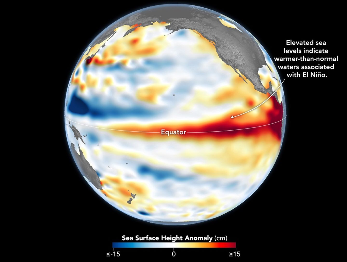
Higher-than-normal sea surfaces (red) are visible in the central and eastern Pacific on June 8, 2026, a few days before El Niño was declared. Data for the map were acquired by the Sentinel-6 Michael Freilich satellite and processed by scientists at NASA’s Jet Propulsion Laboratory (JPL).
NASA Earth Observatory/Lauren Dauphin
El Niño, characterized by warmer-than-normal water temperatures in parts of the equatorial Pacific, made its return in June 2026. Observations of sea surface height from the Sentinel-6 Michael Freilich satellite that month indicated that the 2026 event was continuing to strengthen.
The natural, recurring phenomenon can have widespread effects, typically bringing wetter conditions to the U.S. Southwest and drought to countries in the western Pacific, such as Indonesia and Australia. NOAA declared an El Niño on June 11, after sea surface temperatures in the central and eastern equatorial Pacific measured at least 0.5 degrees Celsius above average for several consecutive months.
Meanwhile, NASA scientists have been observing a complementary sign of El Niño: areas of elevated sea surface height. When ocean water warms, it expands in volume and causes the sea surface to rise—making the water’s height a reliable indicator of ocean temperatures. Warmer-than-normal temperatures, hence higher sea surface heights, in parts of the equatorial Pacific Ocean are associated with El Niño.
The map above depicts sea surface height anomalies across the central and eastern Pacific Ocean as observed on June 8, 2026. Shades of red indicate sea levels that were higher than average. Normal sea level conditions appear white, and lower areas are blue.
Data for the map were acquired by the Sentinel-6 Michael Freilich satellite—launched in 2020 by NASA and led by ESA (European Space Agency)—and processed by scientists at NASA’s Jet Propulsion Laboratory (JPL). Note that signals related to seasonal cycles and long-term trends have been removed to highlight sea level anomalies associated with El Niño and other short-term natural phenomena.
Earlier in spring 2026, the satellite started to detect precursor signs of El Niño as swells of warm water hundreds of miles wide, known as Kelvin waves, moved from the western Pacific to the eastern Pacific. That happens when trade winds in the western equatorial Pacific weaken and then temporarily reverse to blow from the west. Warm water piles up in the east, deepening the warm surface layer, lowering the thermocline, and suppressing the upwelling that usually keeps waters along the Pacific coasts of the Americas cooler.
This buildup of heat beneath the water’s surface is what sea surface height observations capture. It goes beyond surface temperature measurements to indicate how much heat is stored in the subsurface. That’s important because a shallow warm layer might not have much impact on climate and weather, while a large reservoir of heat below the surface can matter more.
According to JPL sea level researcher Severine Fournier, deputy project scientist for Sentinel-6 Michael Freilich, conditions in the western Pacific on June 8 looked similar to those from the same time in 1997, a year when an exceptionally strong El Niño emerged. Warm conditions in the eastern Pacific in 2026 have lagged behind, however, with fewer Kelvin waves built up by the same date.
Still, more warm Kelvin waves appeared to be approaching the eastern Pacific, meaning El Niño was still strengthening. Whether it catches up to 1997 depends on ocean activity in the coming weeks. “For now, it looks like it’s going to be a big one—more so than I would have said last week—but we still need more observations to know what’s going to happen.”
NASA Earth Observatory image by Lauren Dauphin, using modified Copernicus Sentinel data (2023) processed by the European Space Agency and further processed by Josh Willis, Severin Fournier, and Kevin Marlis/NASA/JPL-Caltech. Story by Kathryn Hansen.
China continued its accelerated launch pace with a series of missions, but long silence followed liftoff of a Kuaizhou-11 solid rocket Wednesday, suggesting potential issues.
Amazon now has hundreds of flight-ready satellites standing idle in Florida, waiting to join the company's low-Earth orbit Internet constellation, an Amazon official said Tuesday.
"They're built, and sitting in a payload processing facility waiting for trips to orbit," said Steve Metayer, vice president of Amazon Leo Production Operations, during a teleconference with reporters. "And we're currently manufacturing several satellites a day."
Metayer spoke on the eve of the company's next mission, during which an Ariane 64 rocket will launch three dozen Amazon Leo satellites into orbit from a spaceport in French Guiana. Liftoff is targeted for 7:53 am ET (11:53 UTC) on Wednesday.

 Login