At Earth’s poles, much of the heat leaving the planet is invisible to human eyes. NASA’s two PREFIRE CubeSats are measuring that far-infrared energy directly, and a new animation built from two complete seasonal cycles shows just how differently the Arctic and Antarctic warm and cool. The Polar Radiant Energy in the Far-InfraRed Experiment began […]
Battery materials startup Sila will use a $1.4 billion loan from the U.S. Department of Defense to scale production at its factory in Washington state.
The economist John Maynard Keynes once remarked, “In the long run we are all dead.” From an astronomical standpoint, this is true for the Earth itself. In roughly 5 billion years, the Sun will exhaust the hydrogen at its core and enter the next phase of its life as a Red Giant, where it will swell up large enough to engulf and destroy the Earth.
Currently, the Sun is still in its main-sequence phase, where it fuses hydrogen into helium in its core. Although it remains relatively stable during this phase, it will gradually grow brighter with time. As the Sun shines brighter, the increased heat and radiation will raise Earth’s surface temperature, potentially pushing it past the threshold for life to survive.
One of Earth’s geological processes that helps regulate its surface temperature is the carbon cycle. Over millions of years, carbon moves from the Earth’s interior into the atmosphere as carbon dioxide or CO2, where it functions as a greenhouse gas that traps heat. Plants take in this CO2 through photosynthesis and move carbon through the biosphere.
Meanwhile, rain and rock weathering draw carbon into the oceans and rocks. By pulling CO2 out of the atmosphere, the carbon cycle could mitigate Earth’s warming as the Sun brightens over time. Today, human activities are increasing atmospheric CO2 and warming the planet. However, over billions of years, the carbon cycle could gradually remove enough CO2 from the atmosphere that eventually too little would remain to support photosynthesis.
With these challenges to life on Earth in mind, the researchers Jacob Haqq‐Misra and Eric Wolf investigated how long Earth’s biosphere could last in the distant future. The team used computer models to calculate the balance of energy that Earth would receive and emit over time, accounting for the effects of increasing sunlight and changing atmospheric CO2 concentrations. They followed this up with calculations using the ExoCAM model to determine the temperature and atmospheric conditions of future Earth across different latitudes. They related these conditions to a habitability metric to determine their impact on the biosphere.
To estimate the biosphere’s maximum possible lifespan, the team conducted 29 simulations representing the planet’s conditions over the next 2 billion years. In one set of simulations, the Earth’s carbon cycle contributed little to regulating surface temperature, with the atmosphere’s CO2 concentration fixed at approximately modern levels of 400 parts per million (ppm) and surface temperatures continuing to increase. In another, the carbon cycle worked to keep Earth’s average surface temperature fixed at the modern average of approximately 59℉ (15℃), no matter how much it had to reduce CO2 in the atmosphere.
In the scenario with a fixed CO2 concentration, the team found that in 1.7 billion years, Earth’s surface reached an average of 122°F (50°C), which is too hot for most land plants. After 1.9 billion years, it reached 149°F (65°), becoming too hot for all land plants to survive as temperatures continued to rise.
They also found that in the fixed average surface temperature scenario, atmospheric CO2 dropped below the 150 ppm level that most plants require for photosynthesis within 500 million years. After 1.4 billion years, CO2 levels fell below 10 ppm, leaving only a few land photosynthesizers and aquatic plants alive. After about 1.8 billion years, atmospheric CO2 dropped to 1 ppm, leaving only microbes capable of photosynthesis.
The researchers’ findings generally extend the estimated lifetime of Earth’s future biosphere compared with earlier, simpler models that suggested maximum lifespans of 100 million to 1.5 billion years. However, they clarified that other scientists should verify their results by running tests with other models, especially under extreme conditions of high incoming solar radiation and low atmospheric CO2.
Lastly, Haqq‐Misra and Wolf noted that their model did not account for major evolutionary changes that could help life adapt to future conditions. Over time, plants could evolve to tolerate higher temperatures or lower atmospheric CO2 levels. Future humans or another intelligent species might also engage in large-scale geoengineering projects to prevent the end of life on Earth. If life on Earth proves adaptable enough, the biosphere may endure until a Red Giant fills the daytime sky.
As part of a planned Texas data center, Amazon is investing in an on-site power plant that could reportedly become the largest source of climate pollution in the United States.
A new study is challenging one of the most comforting assumptions in urban climate design: that adding vegetation to dense cities always makes hot weather safer. Research published in npj Urban Sustainability reports that compact, high-rise urban forms can amplify humid heat risks associated with vegetation transpiration—a process usually considered an essential cooling service. The finding does not suggest that trees and plants should be removed from cities. Instead, it reveals that the success of green infrastructure depends heavily on building geometry, airflow, humidity, and the way heat and moisture move through the urban atmosphere.
Vegetation transpiration occurs when plants release water vapor through microscopic openings in their leaves. This process consumes energy and can lower leaf and surrounding air temperatures, much like evaporation from human skin. In a well-ventilated environment, the added moisture may be dispersed efficiently, allowing evaporative cooling to provide a net thermal benefit. But in tightly packed high-rise districts, the same moisture can become trapped between buildings. The result is a more humid microclimate in which the body’s ability to cool itself through sweating is weakened.
That distinction matters because humid heat is more dangerous than air temperature alone suggests. The human body relies on evaporation to transfer heat away from the skin. When atmospheric moisture is already high, sweat evaporates more slowly, forcing the body to work harder to maintain a stable internal temperature. Heat-stress indicators such as wet-bulb temperature and the Wet-Bulb Globe Temperature account for this interaction between heat and humidity. A neighborhood with slightly lower temperatures but substantially higher humidity can therefore feel more oppressive—and pose greater health risks—than a drier location with hotter air.
The study focuses on the urban “canyon” effect created by tall buildings arranged close together. These structures can obstruct wind, reduce the exchange of air with the atmosphere above, and alter the amount of sunlight reaching streets and façades. When vegetation in such spaces transpires, the released water vapor may accumulate rather than disperse. The compact geometry can also create complex circulation patterns, with warm and moist air repeatedly moving through pedestrian-level spaces. In this setting, greenery may cool surfaces while simultaneously increasing the moisture burden experienced by people outdoors.
This is a crucial refinement of the popular idea that urban greening is universally beneficial. Plants perform several valuable functions: they provide shade, intercept solar radiation, reduce surface temperatures, store carbon, and improve the visual and psychological quality of public space. Yet their cooling performance is not fixed. It changes with species, soil moisture, canopy density, irrigation, wind conditions, building height, street width, and background humidity. The new research emphasizes that these factors must be evaluated together rather than treating vegetation as an isolated solution to urban heat.
The implications are particularly significant for rapidly growing cities where vertical development is being used to accommodate rising populations. High-rise construction can reduce land consumption, but dense towers may produce localized atmospheric conditions that differ dramatically from those in surrounding neighborhoods. A cooling strategy designed for an open suburban street may behave differently in a narrow urban canyon surrounded by tall façades. Planners could therefore face a difficult balancing act: maximizing shade and ecological benefits without creating stagnant pockets where moisture and heat combine into dangerous conditions.
The findings also raise questions about how cities measure the success of climate adaptation projects. A street may record a lower surface temperature after trees are planted, yet still expose pedestrians to greater physiological stress if humidity increases and air movement declines. This means future assessments should include multiple variables, including air temperature, relative humidity, wind speed, radiant heat, and human thermal response. Satellite observations and conventional weather stations may not fully capture conditions at street level, where building walls, tree canopies, pavement, and human activity interact within a few meters.
The research is likely to intensify debate over “smart” urban greening rather than green infrastructure in general. Possible responses include selecting vegetation according to local humidity and wind conditions, designing wider or better-connected ventilation corridors, combining trees with reflective or permeable surfaces, and ensuring that shaded areas do not become poorly ventilated enclosures. Building orientation and spacing may be as important as the number of trees planted. Irrigation practices could also matter, since additional water supplied to vegetation may increase transpiration during precisely the periods when atmospheric moisture is already high.
For residents, the message is both cautionary and practical. A leafy street can still be healthier than an exposed one, particularly when shade reduces direct solar radiation. But during extreme heat, people should not assume that every green space offers the same level of protection. Dense, humid, windless areas may require additional measures such as cooling centers, drinking-water access, timed outdoor activities, and heat alerts that account for humidity. The study’s central contribution is to show that urban climate risk is not determined by temperature alone—or by the presence of greenery alone—but by the interaction between city form, plant physiology, and human vulnerability.
As climate change increases the frequency and intensity of heat extremes, these interactions could become more consequential. The research presents cities with a deceptively simple lesson: cooling the urban environment is not just a matter of adding more plants. It requires understanding where the water released by vegetation goes, how buildings control its movement, and how the resulting air feels to a human body. In the race to make cities greener, the next generation of design may need to be equally focused on keeping them breathable.
Subject of Research: The relationship between compact high-rise urban form, vegetation transpiration, humidity, and humid heat risk.
Article Title: Urban high-rise compact form amplifies humid heat risk from vegetation transpiration.
Article References: Zhang, Y., Yang, K., Zhu, Y. et al. “Urban high-rise compact form amplifies humid heat risk from vegetation transpiration.” npj Urban Sustainability (2026). https://doi.org/10.1038/s42949-026-00459-1
Environmental Research: Climatewas launched in 2022, with the aim of uniting multidisciplinary communities. With a scope that is intentionally broad, the mission of the journal is to publish innovative research examining the causes, consequences, and solutions of climate variability and change. Since our launch, we have published more than 270 articles covering physical and biogeochemical processes that shape Earth’s climate across spatial and temporal scales; the human and ecological dimensions that shape climate-related risks and impacts; and the design, analysis and evaluation of climate mitigation, adaptation, and risk-management strategies and solutions. This webinar will explore the current state of climate research, including changes in the field over the last five years since the launch of the journal, and direct us toward the future.
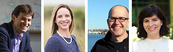
Left to right: Noah Diffenbaugh, Katharine Mach, Andrew Pershing, Inês Azevedo
Moderator: Noah Diffenbaugh, Stanford University
Noah Diffenbaugh is the William Wrigley Professor and Kimmelman Family Senior Fellow in Stanford’s Doerr School of Sustainability, and the Olivier Nomellini Family University Fellow in Undergraduate Education. His research is focused on understanding what aspects of the climate system most directly and acutely impact people and ecosystems. Noah has served as a Lead Author for the Intergovernmental Panel on Climate Change (IPCC), and as editor-in-chief of the peer-review journals Geophysical Research Letters and Environmental Research: Climate. He has provided testimony and scientific expertise to federal, state and local officials. Noah is an elected Fellow of the American Geophysical Union (AGU), a recipient of the James R. Holton Award and William Kaula Award from the AGU, and has been recognized as a Kavli Fellow by the U.S. National Academy of Sciences.
Katharine Mach, University of Miami
Katharine Mach is professor and chair of the Department of Environmental Science and Policy at the University of Miami Rosenstiel School of Marine, Atmospheric, & Earth Science. During spring 2025, she was the Coleman P. Burke Distinguished Visiting Professor at the Yale School of Environment. Her research assesses climate-related risks and response options to address increased flooding, extreme heat, wildfire and other hazards. Through innovative approaches to integrating evidence, she informs effective adaptations to the risks.
Katharine was the 2020 recipient of the Piers Sellers Prize for world-leading contribution to solution-focused climate research. She has served as a chapter author or lead in the Fourth through Sixth US National Climate Assessments and the IPCC Sixth Assessment Report and as a member of the National Academies Climate Security Roundtable. She serves as co-editor-in-chief for Climate Risk Management, an editorial board member for Oxford Open Climate Change and Environmental Research: Climate, and an advisory committee member for the Aspen Global Change Institute. Across all of her research projects, she engages in relevant policy processes and explores and discusses climate risk and adaptation with the media, the private sector, nongovernmental organizations and communities.
Andrew Pershing, Climate Central
As chief programme officer, Andrew Pershing, PhD, leads Climate Central’s climate science activity. His role includes bridging primary research and media analysis to amplify critical work on climate change and climate impacts and make it accessible to audiences around the world. As the director of attribution science and climate fingerprinting, Andrew is developing tools like the Climate Shift Index to quantify how climate change has increased the likelihood or severity of conditions in the atmosphere and ocean. He works closely with communications experts at Climate Central and our partners to help the media and others to incorporate this information into their content.
Andrew has led interdisciplinary research teams to study the impact of global warming on marine ecosystems in the northwest Atlantic. More recently, his work has focused on how climate trends interact with decisions that people make and on how marine ecosystems store and process carbon. As a communicator, Andrew has deep experience working with journalists to present climate science on air and in print.
Inês Azevedo, Stanford University
Inês M Lima Azevedo is a professor in the Energy Science & Engineering department at Stanford University. She is a senior fellow at both Stanford Woods Institute for the Environment and for Precourt Institute for Energy. She has a BSc in environmental engineering (2004) and a MSc in engineering policy and management of technology from IST-Portugal, and a PhD in engineering and public policy from Carnegie Mellon University (2009). Inês is passionate about solving problems that include environmental, technical, economic and policy issues, where traditional engineering approaches play an important role but cannot provide a complete answer. In particular, she is interested in assessing how energy systems are likely to evolve, which requires comprehensive knowledge of the technologies that can address future energy needs and the decision-making process followed by various agents in the economy.
About this journal
Environmental Research: Climate explores the causes, consequences, and solutions of climate variability and change, by uniting research communities across the entire spectrum of the climate system.
Editor-in-chief: Noah Diffenbaugh Stanford University, USA
The frequency of extreme weather events can be predicted more accurately than presently possible by combining artificial intelligence (AI) with physical climate modelling, using a protocol called rare-event sampling. That’s the conclusion of a study from researchers in the US and France. The researchers used the approach to model extreme heat events such as the one currently roasting Europe, but they believe it could also be applicable to many other extreme events in climate science.
As the global climate warms, extreme weather is becomingly increasingly deadly and difficult to predict, and quantifying the risks of such events is important for climate change adaptation and mitigation. “Very often the rarest events carry the largest impacts,” says climate physicist Amaury Lancelin of France’s Laboratory of Dynamic Meteorology.
Full global climate model simulations will need to run for an infeasibly long time to produce sufficient data for an estimate of the precise frequencies of rare events. Alexander Wikner of the University of Chicago in Illinois gives the example of an event that, on average, occurs once every century: “Each year you’re going to flip a coin that has a one-in-a-hundred chance of coming up heads,” he says. “On average, once every hundred years, you’ll get one head, but you could very easily get no heads or two or three heads.” A meaningful estimation of the frequency therefore would traditionally require around a thousand years’ worth of simulation – which is not computationally feasible in a physical model.
Deep-learning algorithms, which ignore the underlying climate physics and simply train themselves using pattern recognition, require up to 10,000 times less computing power. However, the reliability of these in modelling extremely rare events is questionable. For example, there is evidence that an AI model will not predict more extreme cyclones than it has seen in its training data, “which is a quite unnerving idea if we imagine that tropical cyclones will be getting more extreme in the future and we want to use an AI model to forecast them,” Wikner explains. They also produce no insight into the physics of the events.
Rare-event sampling (RES) refers to techniques that preferentially allocate computing resources to specific rare events of interest, thereby avoiding modelling long periods of time in which none of those events occur. The problem, of course, is that one has to have some idea what kinds of conditions increase the probability of a rare event occurring in order to know which periods to model in more detail.
In the new research, scheduled for publication in Physical Review Letters, Lancelin, Wikner and colleagues developed the AI+RES framework. An AI algorithm runs climatic simulations repeatedly and selects those that it predicts are most likely to lead to the rare event. A full climate model then simulates only these. The researchers used this protocol to compare the frequency of heatwaves at mid-latitudes, using the predictions of a relatively coarse-grained direct numerical simulation called PlaSim as the ground truth.
They found that their technique produced similar results to PlaSim with up to 1000 times lower computational resources. The researchers now hope to apply the technique to predict other types of extreme events and apply it to more sophisticated models.
“The reason we used PlaSim is that it is computationally quite cheap compared to state-of-the-art climate models so that we can actually verify that our methodology works,” says Lancelin. “Otherwise there is no way to know whether we have made a garbage prediction or not without the ground truth.” Knowing that the AI+RES model reproduces the PlaSim results correctly, however, the researchers now hope to apply computationally expensive models in situations where it was previously impossible, with confidence that the results are likely correct.
Climate scientist Robin Noyelle of ETH Zurich believes the work marks a significant contribution to ideas that were already “floating out there”. He says that, although RES has been in use for nearly ten years, selecting the best candidates for full modelling has always proved challenging: “People were using things that we thought were reasonable – I did that during my PhD – so if I want to look at hot summers, then I select on temperature.”
This approach fails for short-term extreme events, however, because of the dynamic nature of the atmosphere. The AI model itself also failed to produce good accuracy when emulating the events, but it was “basically free” in terms of the computing power required, and provided a good starting point for the physical models. “This coupling between the two ideas is really new,” Noyelle says.
Artificial intelligence (AI)-based weather models are not as good as physics-based forecasting systems at predicating extreme weather events, say researchers at the University of Geneva, Switzerland and the Karlsruhe Institute of Technology, Germany. After comparing the outputs of different models on the same dataset of extreme events, the team found that AI models systematically erred on the side of normality, underestimating temperatures for extremely hot events while overestimating them for cold ones. This could be because the models learn from what has already happened and struggle to forecast events outside their training data.
With extreme weather events growing more common and intense due to our rapidly warming climate, being able to predict them is becoming ever more important. In recent years, meteorologists have sought to address this by developing a new generation of AI models that vie with physics-based numerical weather prediction (NWP) systems in the accuracy and extent of their forecasts – at least for everyday weather events.
Black or grey swans
In the new work, researchers led by Zhongwei Zhang and Sebastian Engelke sought to understand whether AI could also be competitive when forecasting extreme weather episodes. These episodes are usually defined by variables such as wind, atmospheric pressure or temperature falling well outside norms for location and season, and are sometimes termed “black swans” or “grey swans” depending on how extreme they are.
“In the past, only relatively moderate extremes were documented,” Zhang and Engelke observe. “But given the current rate of high rate of global warming, record-breaking events now sometimes exceed previous record levels by large margins.”
To test this hypothesis, Zhang and Engelke constructed a large dataset of record-breaking events for heat, cold, and wind extremes during 2018 and 2020. This dataset included several well-known events, such as the Siberian heatwave in early 2020 and the US heatwave of August 2020, but also tens of thousands of less-heralded ones. The 2020 dataset, for example, included 162,751 heat, 32,991 cold, and 53,345 wind records spread across different seasons and climatic zones.
The researchers assessed how well the three leading deterministic AI weather models –GraphCast, Pangu-Weather (and operational variants) and Fuxi – performed when extrapolating from this dataset of record-breaking events. They then compared these models’ performance to that of the physics-based High RESolution forecast (HRES) model developed by the European Centre for Medium-Range Weather Forecasts (ECMWF), which is widely acknowledged as today’s best physics-based NWP model.
In line with previous studies, the researchers found that both GraphCast and Fuxi were better than HRES at forecasting normal weather events. However, for record-breaking temperature and wind events in 2020, the situation was reversed, with the physics-based HRES model consistently outperforming all AI models for hot and cold temperature records as well as wind speed records.
A difficult study
The researchers report that the most difficult aspect of the study was the sheer length of computation time required to analyse huge AI and numerical forecast datasets. To complicate things further, Zhang notes that some of the most recent AI weather models are being developed by big tech companies and are not publicly available.
As well as showing that purely data-driven AI models struggle to forecast record-breaking extreme weather events, Engelke says the team’s work also provides a protocol for systematically evaluating forecasts of extreme events. “We hope this will motivate the research community to thoroughly evaluate the next generations of AI forecasts to advance our understanding of their advantages and their limitations compared to conventional physics-based models,” he says.
In this study, which appears in Science Advances, the Geneva/Karlsruhe researchers focused on evaluating the forecasts of deterministic AI weather models. They are now doing the same for forecasts made by recent probabilistic AI weather models, which they suspect will face similar extrapolation limitations.
“We are also working on building AI models ourselves that have improved forecast performance on extreme events,” Zhang and Engelke reveal. “This might be achieved this by creating hybrid models, which are a smart combination of physical and AI-based weather models.”
The inferno that sent toxic smoke billowing toward the United States won't be the last. Officials are now battling both the wildfires and misinformation.
A 201-million-year-old climate catastrophe turned Europe into a landscape of fern savannahs that repeatedly caught fire, according to new research published in the journal Nature Geoscience.
Planetary researchers have found the first evidence that bursts of energetic particles from the Sun could warm the lower atmosphere of Mars during massive dust storms, hinting at an unexpected link between space weather and Martian climate.
Climate scientists are warning us to buckle up for a bumpy ride. An El Niño has begun. By year’s end, this periodic climate event might become the strongest El Niño on record.
An El Niño Southern Oscillation, or ENSO, is a recurring two- to seven-year ocean-climate pattern. On June 11, the U.S. National Oceanic and Atmospheric Administration confirmed Earth has officially entered the El Niño phase of this cycle.
El Niño events emerge in the Eastern Pacific. Eventually, the changes in climate they spawn will affect weather globally. And the stronger an El Niño, the more costly it can be to human health, farming, buildings and our wallets.
Forecasters currently predict a 63 percent chance that, by winter, the new El Niño will prove very strong — as in a “super El Niño.”
Here are four things to know as this climate pattern takes hold.
What’s an El Niño?
An ENSO’s several-years-long cycle has three phases.
The first, known as El Niño, involves months of warmer than normal sea-surface temperatures in the eastern equatorial Pacific. Back in the 1600s, fishers in Peru noticed this warming tended to show up around Christmas. So they dubbed it “El Niño,” which is Spanish for “little boy.” It’s also the name given to “the Christ child.”
A second phase — La Niña (or little girl) — swings to cooler than normal temps in those eastern Pacific waters near the equator.
The last is a neutral, in-between phase. It brings average temperatures back to the Pacific’s equatorial sea surface.
The “Southern Oscillation” part of ENSO’s name refers to another seesawing pattern. Here the swings are between areas of high and low atmospheric pressure over the eastern versus western Pacific Ocean. That up-and-down pressure pattern triggers global-scale changes in winds, air temps and precipitation.
Scientists track ENSO air-pressure changes at two main stations. One is in the West Pacific at Darwin, Australia. The other is in the East Pacific at Tahiti (part of French Polynesia).
During neutral periods and La Niña phases, the high-pressure zone is in the east. That sends prevailing winds westward across the Pacific around the equator. These winds push the warming surface waters of the Pacific to the west. This keeps them away from the coast of the Americas.
In so doing, it allows cold, nutrient-rich water to well up from the deep ocean. That keeps the eastern equatorial Pacific waters cold.
But every few years, conditions flip. Now high pressure prevails over the western Pacific, and lower pressure over the eastern Pacific.
This weakens or even reverses the direction of the prevailing winds. It also allows warm surface waters to stay in place. This suppresses the upwelling of cold water. Now sea-surface temps warm rapidly in the eastern Pacific. This also serves as a telltale sign an El Niño is back.
No two El Niño events are exactly alike, says Tom Di Liberto. He’s a climate scientist and meteorologist now working for the nonprofit news group Climate Central. It’s based in Washington, D.C.
But each El Niño transfers huge amounts of heat from tropical Pacific waters into the air. That bonus heat can temporarily — and dramatically — boost air temperatures around the globe.
An El Niño officially starts when sea-surface temperatures in the eastern equatorial Pacific Ocean steadily remain at least 0.5 degree Celsius (0.9 degree Fahrenheit) above average for several months. The warmer the waters, the stronger an El Niño’s likely global impacts.
Waters warmer than 2 degrees C (3.6 degrees F) above average signal the emergence of a very strong — or “super” — El Niño.
This Philippine farmer was trying to salvage any surviving water-pond plants during the super El Niño in April 1998. He hoped to feed local people and livestock. Seven Philippine corn and rice growing provinces were declared a state of calamity after their crops were totally destroyed by this El Niño’s long, severe drought.Romeo Gacad/AFP/Getty Images Plus
Since April, temps over the eastern equatorial Pacific Ocean have remained well above average. Dozens of forecasters around the world concluded an El Niño was on its way. By June, as the ocean warmed even more, their forecasts began to warn that this could prove a really powerful event.
Recently, climate change has made detecting an El Niño’s onset and strength more difficult. Why? Global temperatures have been warming steadily over the last decade, which can mask an emerging El Niño. So in May, NOAA’s Climate Prediction Center adopted a new tool for its El Niño forecasts. This now adjusts for that climate change–related warming.
Using this new tool, NOAA predicts that this winter, sea-surface temps in the eastern tropical Pacific are 63 percent likely to be more than 2 degrees Celsius higher than average. That’s what suggests a super El Niño is developing.
In fact, computer models are now forecasting “shockingly high” global temperatures for November and December, Di Liberto says.
Such heat can have deadly consequences. A rise in heat-related illnesses is one. Another is upticks in diseases (such as cholera, typhoid and malaria) carried by mosquitoes and other pests that like it hot.
El Niños also alter the track of the Pacific jet stream. The result: Some areas will become drier than normal. Others will get wetter.
For the United States, one of the most significant impacts will likely be more numerous and intense Pacific cyclones. At the same time, changing wind patterns can make it harder for Atlantic hurricanes to form.
Fortunately, the life of any one El Niño is relatively short: Events typically form in the summer, strengthen into the winter, then die out the next spring.
People in Locotal, Bolivia, check out a major road after torrential rains washed out a large section of it on January 9, 1998. Meteorologists attributed the flooding rains and mudslides here to a powerful El Niño, which had been triggering extreme weather events around the globe.STR/AFP/Getty Images Plus
How will this year compare to past major El Niños?
The most recent strong El Niños happened in 2015–16, 1997–98 and 1982–83.
The 1997–98 event was the strongest on record. It temporarily raised average global temps by 1.5 degrees Celsius (2.7 degrees Fahrenheit) and triggered devastating weather events.
These included torrential rains and floods in Peru and East Africa. Those, in turn, triggered an outbreak of Rift Valley Fever in Africa. Droughts in Southeast Asia kicked off deadly wildfires. California saw powerful storms that brought major flooding and landslides. Soaring ocean temperatures led to the bleaching of about one-sixth of the world’s coral reefs.
Such strong El Niños are costly, too. The 1982–83 one cost the world an estimated $4.1 billion. The 1997–98 event was estimated to cost about $5.7 trillion.
How bad this year’s event will be is still unclear. But it’s occurring on top of strong global warming from human activities. And even if this year’s turns out to be only moderately strong, Di Liberto says, its impacts could still be very big. “It would not take a very strong El Niño to see records broken this year.”
Here a BBC meteorologist offers a snapshot of why weather forecasters are worried about the developing El Niño and how its impacts could play out across the globe.
To work, these aerosols would have to be targeted over a particular patch of the Pacific Ocean. This should increase and brighten clouds there, a new computer model finds. And that would reflect more of the sun’s warming light back into space, cooling the climate.
The idea for this was sparked by the 2019–20 Australian wildfires, says Jessica Wan. She’s a climate scientist at the University of Chicago in Illinois. Those fires spewed huge billows of particles into the air. Plumes of them wafted over the southeastern subtropical Pacific Ocean. This brightened clouds there — and helped trigger a multiyear La Niña.
This natural “experiment” hinted at how altering clouds in the proper region can change large climate patterns, says Wan. Her team’s computer model has now calculated what would happen if people injected a huge quantity of aerosols into the atmosphere (as the wildfires had). This should weaken an El Niño. But how much weaker it got would depend on when the injection took place, the model finds. The strategy seemed to work best when done early in an El Niño.
This idea “is really interesting and very new,” says Daniele Visioni. He’s a climate scientist at Cornell University in Ithaca, N.Y. who did not take part in this new study. To him, “the fact that it looks like this could work is a really good indication that it is something worth thinking about.”
But it’s not a strategy that could work for this year’s El Niño. There are too many big questions to answer first, Wan says. For one thing, the technology to inject particles is years from being ready. Plus, there needs to be more study about the possible negative consequences of injecting aerosol particles.
A new genus and species of cryptobranchid salamander that lived in lakes in Japan about 3.5 million years ago has been identified from three fossil vertebrae, filling a major gap in the fossil record of one of the world’s oldest amphibian lineages.

 Login