What's in the photo? The lava-stained slopes and ash cone of a highly active volcano
Who took the photo? An unnamed astronaut on board the International Space Station
When was it taken? Oct. 6, 2020
This dramatic astronaut photo shows a highly active stratovolcano in Tanzania that was recently adorned with a striking white "crown" of ash. The explosive volcano produces a rare type of lava that is unusually cool, uniquely colored and the fastest-flowing on Earth.
The volcano is officially named Ol Doinyo Lengai and stands up to 9,718 feet (2,692 meters) above the grassy plains of the Arusha region of northern Tanzania. The local Maasai people call the towering peak the "Mountain of God," because they believe it is the residence of the supreme creator god Ngai (also known as Engai or Enkai), according to the book "Sacred Mountains of the World" (Cambridge University Press, 2022).
Ol Doinyo Lengai is one of Africa's most active volcanoes; it has been erupting on and off for the past 15,000 years. It alternates between effusive eruptions, where lava seeps out of its vents, and sporadic explosive outbursts, which can drastically alter its appearance. Its most recent eruption, which is effusive, has been going on since April 2017, according to the Smithsonian Institution's Global Volcanism Program.
The sacred mountain produces a rare type of lava that consists of natrocarbonatite rock, which is rich in sodium, potassium and calcium carbonate but low in silica. As a result, it is much cooler than most other lava, dipping to temperatures below 1,100 degrees Fahrenheit (600 degrees Celsius). It also has an unusually low viscosity, which makes it "some of the fastest-flowing lava in the world," according to NASA's Earth Observatory.
When it solidifies, this unusually runny lava turns surprisingly pale, due to chemical reactions with rainwater and moisture in the air. In this image, you can see several lightly colored rivers of rock snaking down the volcano's flank. The youngest of these lava flows was created during an eruption in 1998.
For most of the past century, Ol Doinyo Lengai's summit consisted of a bowl-like depression that gradually filled with lava. But between 2007 and 2008, a series of major explosive eruptions birthed a 330-foot-tall (100 m) ash cone that now looms over the summit's center.
This explosive event has transformed the volcano's appearance when viewed from space, additional photos from the Earth Observatory show. In the featured image, a dark spot of fresh lava can be seen in the center of the cone, making it look like a crown.
Lake Natron, near Ol Doinyo Lengai, hosts large flamingo populations. (Image credit: TONY KARUMBA/AFP via Getty Images)
Ol Doinyo Lengai is located in the East African Rift System, a roughly 2,000-mile long (3,500 kilometers) area surrounding a divergent fault line where the African Plate is splitting into the Somali and Nubian plates.
This region has been tectonically active for more than 25 million years and has created some of the continent's most interesting topographic features, including Mount Kilimanjaro and Mount Kenya, which are located on each side of Ol Doinyo Lengai, according to the Earth Observatory.
The godly mountain is around 10 miles (16 km) south of Lake Natron, a red salt lake that's famed for its large flamingo populations. The geographical features are often photographed alongside one another.
A 2020 astronaut photo shows three uniquely colored lakes — Tahoe, Walker and Mono — straddling contrasting biomes on either side of the California-Nevada border.
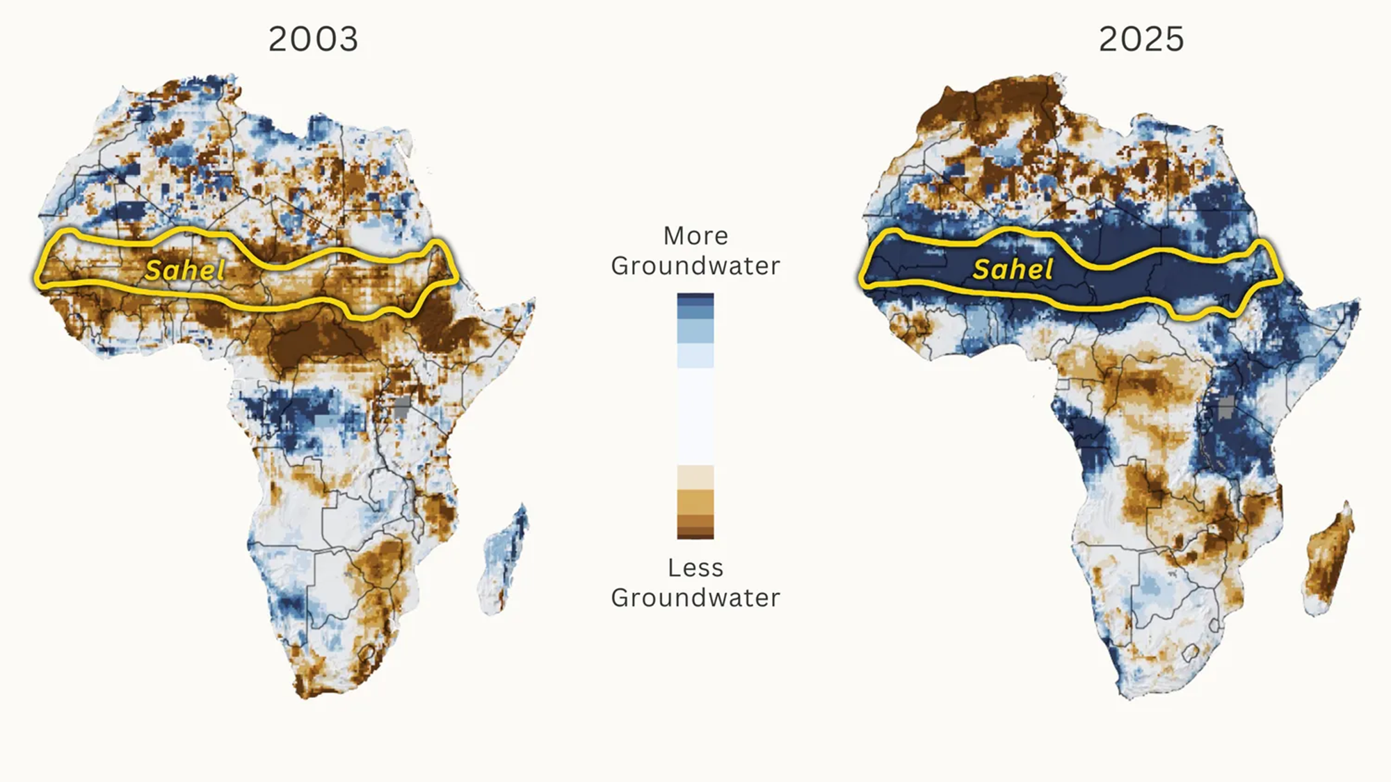
Near-extinct oryx are returning. Farms are prospering as irrigation water reaches fields for the first time in decades. Farmers are even nurturing new trees on their land.Once a byword for drought and famine, the African Sahel region on the southern flank of the Sahara Desert now has more water than it has for decades. Wells are filling as water tables have risen by 13 feet or more in places. Lake Chad, which was one of Africa's largest expanses of water before shriveling during the droughts, is recovering.
Over years of drought in the late 20th century, the sun hard baked the soils of the Sahel. Now, erratic but extreme rains are returning to this semi-arid region, causing lethal floods but also replenishing rivers, filling desert depressions, restoring water to dried riverbeds known as wadis, and sluicing rainwater off impermeable soils directly into aquifers. The process began in the 1990s but has accelerated in the past five years.
"Across the Sahel, from Ethiopia to Senegal, we have evidence of increased terrestrial water storage," says Richard Taylor, a hydrogeologist at University College London who has led ground teams investigating the relationships between climate, land use, and groundwater recharge in the region.
But increased rainfall since the drought years of the 1970s and 1980s explains only some of the rewetting of the Sahel. It cannot fully account for the transformation, say researchers. Also driving the rewetting, they posit, are changes to the land surface, ranging from the internationally funded Great Green Wall project to the revival of traditional water harvesting methods and the chaos caused by jihadist militants, which has led to the abandonment of irrigation projects that once emptied rivers of their flows.
Much remains unclear in these remote lands on the edge of the Sahara Desert, but the trend seems set to be long-term, with climate scientists saying more — and more extreme — rainfall is on the way in the 21st century. As underground water reserves revive, some are forecasting an agricultural renaissance.
The Sahel is a band of semi-arid land around 500 miles wide that stretches across North Africa, from Senegal in the west to Ethiopia in the east, with a fast-growing population above 150 million. It is a transition zone between the Sahara Desert in the north and savanna grasslands and coastal forests to the south. Water is everything in the Sahel. Its rains are critical to human survival, but they have been sporadic and unpredictable since the close of a humid era around 5,000 years ago.
Shallow groundwater storage in February 2003 and February 2025, as compared to the average from 1948 to 2012. (Image credit: NASA / Adapted by Yale Environment 360)
How much rain the Sahel gets depends on the West African monsoon, a wet wind that sweeps north from the Gulf of Guinea between June and September, and on how far the monsoon penetrates into the interior. Whether it reaches the 15th parallel north of the equator or stalls at the 10th parallel make the difference between a good year and a failed harvest, say hydrologists.
During the droughts of the late 20th century, as the monsoon repeatedly fell short, up to a million people died of hunger and disease. But now, with a strengthening monsoon, there is talk among scientists of the Sahel being on the verge of a new humid era.
That is good news for wildlife. With wadi systems reviving in Chad's Ouadi Rimé-Ouadi Achim nature reserve, conservationists are documenting resurgent numbers of aardvarks, porcupines, badgers, and foxes, and the successful reintroduction of the scimitar-horned oryx, which was once declared extinct in the wild but now numbers more than 600 individuals. Elsewhere, West African giraffes are browsing on verdant vegetation in areas from which they had disappeared.
As the rains return, farmers have boosted crop yields by nurturing the natural regrowth of some 200 million trees on formerly treeless fields in southern Niger, according to former World Resources Institute geographer Chris Reij. And, supported by new aid programs such as the World Bank's regional recovery program PROLAC, they are re-establishing small-scale irrigation systems by tapping groundwater around resurgent oases in Chad, Niger, and Cameroon.
"In the past … there was not enough water to irrigate crops, and our harvests were meager. Now our lives have changed," Achta, a farmer in Chad, said last year. She now has water to plant on four times as much land and has doubled her onion crop. The Bank says her story "reflects a broader transformation across the Lake Chad basin."
Most places in the Sahel are seeing more rainfall. And that rain has become concentrated in extreme downpours from clusters of violent thunderstorms, known to meteorologists as Mesoscale Convective Systems, that occasionally bubble up during the monsoon season. Sahelian storm clusters are now rated as some of the most powerful on the planet, and they deliver most of the region's rainfall. There has been a threefold increase in the frequency of extreme storms since the 1980s, according to a recent analysis.
Why the revival of the rains? An assessment published in 2021 by the U.N.'s Intergovernmental Panel on Climate Change found "high confidence" among climate scientists that it is a result of strong warming in the North Atlantic, caused by a combination of global heating and a reduction, in Europe and North America, of sulphate aerosols from coal burning, which once created a thin haze that cooled the ocean. That cooling prevented the northward migration of the West African monsoon into the Sahel, resulting in drought. But the clean-up has warmed the ocean and pulled the monsoon back into the Sahel, strengthening its ability to produce deluges.
The streets of the Keurs Massar area in Dakar are flooded on Sept. 7, 2020 after a monsoon in Senegal. (Image credit: SEYLLOU via Getty Images)
The effects of these mega-storms are especially challenging in a region more used to disasters caused by the absence of rain. Niger, one of the world’s 10 poorest countries, saw tens of thousands die from famine during the late 20th century droughts. Now, it sees more deaths from floods than droughts. Fierce storms during the 2024 monsoon season inundated the capital, Niamey, and in rural areas washed away more than 150,000 mud-brick homes.
Sudden downpours are initially destructive, but they are a boon to underground water reserves. Falling onto compacted ground, the water does not initially infiltrate the soil but rushes into rivers and dry wadis, which speed the water's flow into aquifers.
Hydrologists say that this indirect infiltration is most intense after heavy storms. "In some locations, rainfall intensity is more important than the annual rainfall amount in determining the magnitude of groundwater recharge," says Taylor. This intensity, he says, is a major cause of the rapid rising of water tables — especially since, in the Sahel, most water drains not to the ocean but inland to depressions and lakes.
Not only are new ponds forming across the formerly arid lands; ancient networks of wadis are being restored. And Taylor's network of researchers has found wells across the region refilling. Mean water tables in much of Niger have risen by some 13 feet, indicating a 15 percent increase in aquifer reserves.
This local data is now being corroborated by analysis from satellites that measure changes in land mass by tracking subtle changes in gravitational force from the land below. NASA's Gravity Recovery and Climate Experiment mission has found a sharp increase in gravitational force across the Sahel in the past two decades that hydrologists attribute to growing terrestrial water storage.
But rainfall and its intensity are only part of the story. Events on land also play a part.
Environmentalists have long held that the encroachment of agriculture into the Sahel during the 20th century caused "desertification" by removing natural vegetation, destroying soils, and allowing the advance of desert sands. But hydrologically, the effect may be the opposite because some crops can actually help the land retain water.
All vegetation absorbs moisture from the soil before transpiring it into the air. But shallow-rooted African grain crops such as millet and sorghum transpire less moisture than the deeper-rooted grasses they replace, leaving more moisture in the soil.
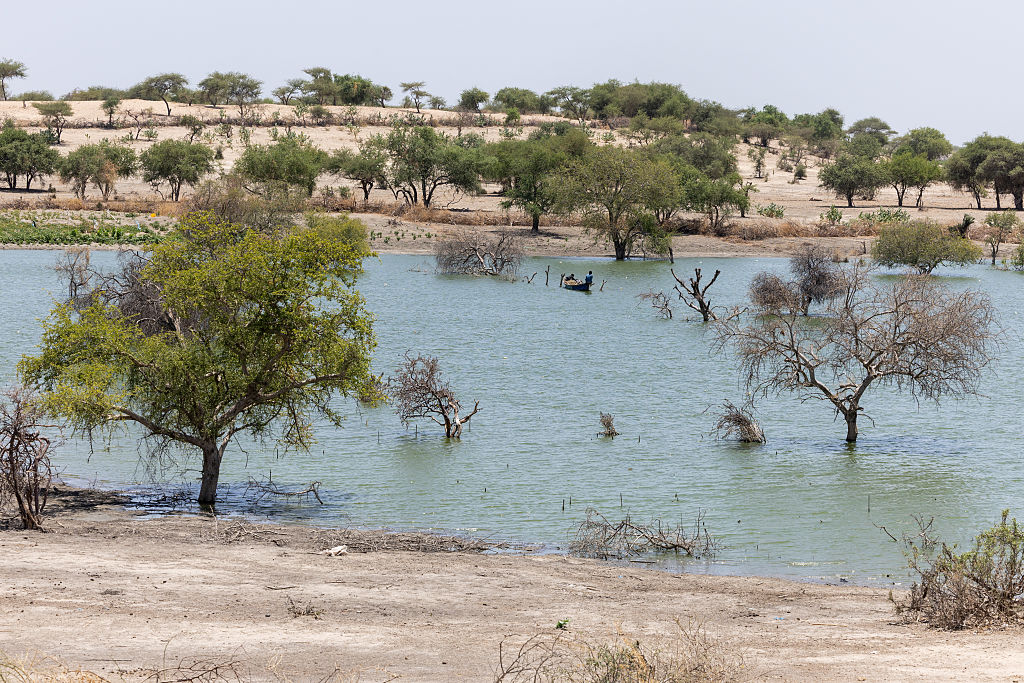
Dead trees in an arm of Lake Chad near Kiskawa, Chad, that was recently flooded. (Image credit: JORIS BOLOMEY via Getty Images)
An amplifying factor is the drought-driven crusting of soils, which has increased runoff by around 50 percent in the central Sahel in recent decades. Analysis by Christophe Peugeot, a hydrologist at the HydroSciences laboratory at the University of Montpellier in France, found that the droughts "have permanently transformed the region's soils… fueling today's floods."
Much of this runoff ends up in Lake Chad, on the border between Nigeria, Cameroon, Chad, and Niger, which drains an area almost six times the size of California. The lake's dramatic demise became a totemic image of the late 20th century hydrological decline of the Sahel. But less well known is that the lake is now recovering, as water inflows increase. Hydrogeologists at the University of N'Djamena in Chad report that in 2024 it swelled to a peak of more than 9,000 square miles, almost as big as in the 1960s and 10 times its size in the mid-1980s.
This growth is partly masked by large areas of saturated vegetation in the lake that do not show up in satellite images, say hydrologists. But as the lake grows, the aquifer beneath is also refilling.
Some researchers argue that deliberate efforts to capture rain in soils can also help explain the rising groundwaters across the region. One such effort is the Great Green Wall. Originally planned as a barrier of planted trees to prevent the advance of the Sahara, it has morphed into more grassroots efforts to control soil erosion by capturing rainfall and improving soil moisture, all of which can improve infiltration underground.
Many such projects revive traditional water-harvesting techniques, including the placement of stones along hill contours, digging small holes known as "zai pits" amid crops, and forming crescent-shaped mounds around trees.
Alpha Lo of the Climate Water Project, who highlighted the restored Sahelian groundwaters in a recent online analysis, argues that such techniques are "the primary reason." But most researchers believe that, while locally effective in nurturing trees or crops, they are not happening at sufficient scale to explain the region-wide resurgence.
A final suggestion is that humans are extracting less water from rivers, leaving more to eventually infiltrate into aquifers. One driver of this trend is the decline of big irrigation projects that were constructed during the drought years to boost food production. For instance, Cameroon once largely emptied the River Logone, historically the biggest single source of water flowing into Lake Chad, to grow rice. But the SEMRY irrigation project reportedly diverts much less water now, due to poor management, aging infrastructure, and the outmigration of farmers.
In areas around Lake Chad, farmers have also abandoned their irrigated fields because of Boko Haram, a militant jihadist group that continues to terrorize communities. Timmo Gaasbeek, food security policy officer at the Netherlands Ministry of Foreign Affairs, says the chaos in northern Nigeria "means that the water in the rivers is not caught upstream, and continues to flow into Lake Chad, where it contributes to higher water levels and more groundwater recharge."
Most climate models predict a further increase in annual rainfall in the coming decades, due to global heating and the banishing of cooling aerosols from the North Atlantic. Taylor predicts that "the Sahel will experience particularly marked increases in extreme rain" that will "serve to increase groundwater recharge."
Peugeot says that "the increased availability of water in valley bottoms could promote the development of irrigation, offering new prospects in several Sahelian regions." Buoyed by such predictions, Nigeria is looking to restore the 165,000-acre South Chad Irrigation Project on the former shores of Lake Chad, which has long been abandoned for want of water.
But the road ahead will not be straightforward. Sahel rains will continue to be erratic on all timescales. Most immediately, climatologists are predicting that this year's strong El Niño event could deliver drought in the eastern Sahel, but bumper rains and more floods further west.
Yams and sweet potatoes are often confused, and the names are sometimes used interchangeably in the U.S. However, they're two different crops. So what sets them apart?
The differences lie mainly in these vegetables' classifications, plant growth, and nutritional profiles, experts told Live Science.
Despite both growing underground and appearing somewhat similar, "Botanically, sweet potatoes and yams are not closely related, as they belong to different plant families," said Phillip Wadl, a research geneticist at the U.S. Vegetable Laboratory in Charleston, South Carolina. Sweet potatoes (Ipomoea batatas) are in the morning glory family (Convolvulaceae). Yams (Dioscorea), by contrast, belong to the Dioscoreaceae family, and there are 11 yam species cultivated for food and income, Wadl told Live Science in an email.
Yams and sweet potatoes also belong to different plant groups, or "cotyledon types," said Jeffrey Cole Denis Gregorie, a sweet potato specialist at the Sweet Potato Research Station in Chase, Louisiana. Yams are monocots, plants whose embryo has only one cotyledon, or seed leaf, like grasses and lilies. Sweet potatoes are dicots, plants with two embryonic seed leaves, which include many fruits and vegetables, such as grapes, squash, strawberries and tomatoes.
In addition, yams and sweet potatoes store food in different parts of the plant. "Sweet potatoes form storage roots which are enlarged parts of the root system," Wadl explained, "whereas yams form tubers, which are enlarged underground stems for nutrient storage."
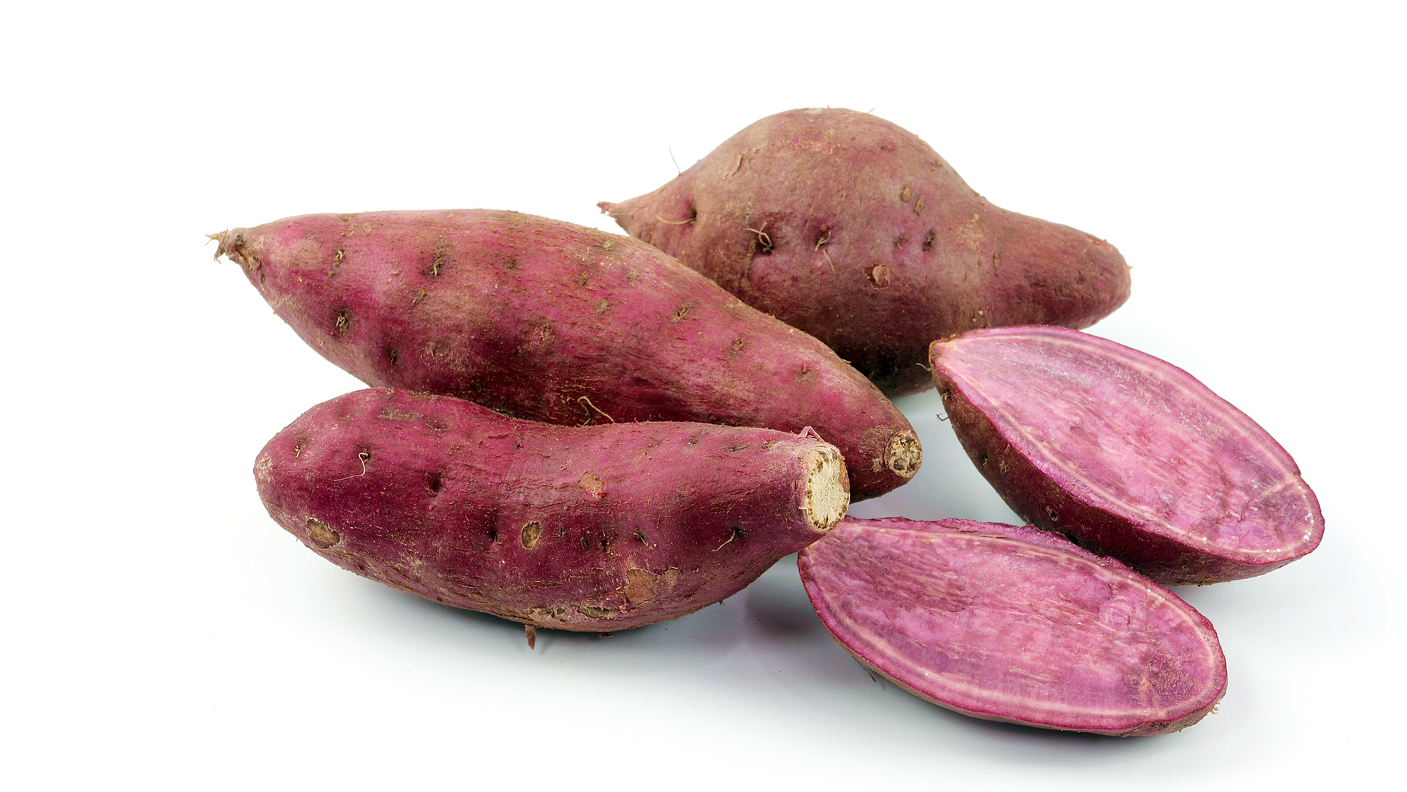
The "garnet yam" is actually a sweet potato. (Image credit: Sarawuth123 via Getty Images)
A single sweet potato plant typically produces about four to 10 sweet potatoes, while a yam plant yields about one to five yams. Sweet potatoes generally take about three to five months to mature, compared with about six months to a full year for yams, according to Craig Yencho, a professor of horticultural science and a sweet potato and potato researcher with North Carolina State University.
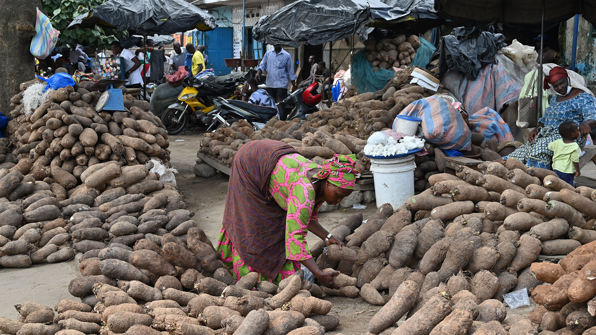
Visually, sweet potatoes and yams are easy to tell apart when you know what to look for. Sweet potatoes tend to be shorter and blockier, with tapered ends. Yams are usually long and cylindrical, sometimes with "toes," or branching shapes.
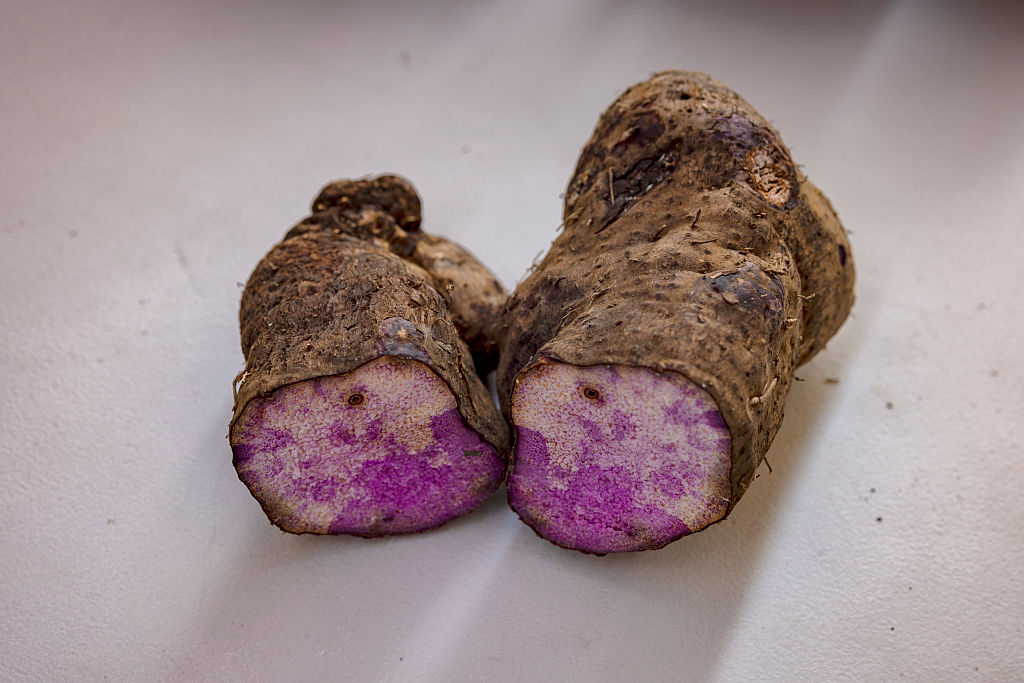
Sweet potatoes come in various flesh colors, including orange — the most common color in the U.S. — as well as yellow, purple and white. Their skin is typically thin and smooth, whereas "yams often have a rough, bark-like skin and their flesh can be white, purple or reddish," Wadl said. One well-known purple yam, known as ube (Dioscorea alata), is a popular ingredient in treats such as ice cream, cookies and pound cake.
Sweet potatoes and yams also have noticeable differences in their culinary and nutritional profiles, Wadl said. "Sweet potatoes are generally sweeter and have a moist, creamy texture when cooked, although dry types are available," he explained. "Yams, on the other hand, tend to be starchier, drier, and have a more earthy, sometimes less sweet, flavor compared to sweet potatoes. Their texture can be more like a regular potato."
Nutritionally, the two crops are quite different, too. Sweet potatoes, particularly the orange-fleshed varieties, are an excellent source of beta-carotene (a precursor to vitamin A), vitamin C, dietary fiber, potassium and some B vitamins. "While nutritious, [yams] typically contain less beta-carotene than orange sweet potatoes," Wadl noted. Instead, yams are a good source of potassium, vitamin C, manganese and dietary fiber.
Sweet potatoes are generally considered safe to eat both raw and cooked, Wadl said. By contrast, many wild varieties of true yams, especially those not cultivated for commercial consumption, contain compounds like dioscorine that could make them toxic to humans if eaten raw. "These must be thoroughly cooked to remove the toxins and make them safe for consumption," Wadl said.
A woman sells yams in the market in Abobo in the Ivory Coast on April 22, 2020. (Image credit: ISSOUF SANOGO via Getty Images)
Thanksgiving confusion around yams and sweet potatoes
If yams and sweet potatoes are so different, why do so many Americans call sweet potatoes "yams"?
Part of the answer lies in history. The yam was a key provision on voyages of enslaved people from West Africa to the Americas, "used to feed captives a familiar food," said Judith Carney, a professor of geography at UCLA. "In mainland plantation societies of North America where the African yam could not be grown, the sweet potato served as a substitute dietary staple." Because the two crops shared some characteristics, "the word 'yam' came to refer vernacularly to both tubers in mainland America, as we see in the U.S. today," Carney told Live Science in an email.
A purple yam, known as ube, from the Philippines. (Image credit: Ezra Acayan / Stringer via Getty Images)
The U.S. sweet potato industry also leaned into the confusion, adopting the term "yam" for marketing reasons, Gregorie told Live Science in an email. "In the United States, many orange-fleshed, moist varieties of sweet potatoes are often mislabeled as "yams" to distinguish them from the drier, white-fleshed sweet potato varieties," Wadl explained.
As a result, the "yams" at most U.S. supermarkets are probably sweet potatoes. "Garnet yams" and "jewel yams" aren't actually yams, despite those labels; instead, they're softer, sweeter varieties of sweet potatoes, according to the University of California, Davis.
Although genuine yams are sold in many international markets in the U.S, "if you're buying a "yam" in a typical U.S. supermarket, you're almost certainly purchasing a sweet potato," Wadl said.
Why it's incredible: The park hosts prehistoric-fossil-bearing rock formations and overlies one of the world's biggest aquifers.
Nestled within Brazil's Cerrado tropical savanna — the second-largest biome in South America, after the Amazon rainforest — Uberaba Geopark is a time capsule from the Late Cretaceous period (100.5 million to 66 million years ago).
The geopark boasts abundant, well-preserved fossils from the last chapters of the nonavian-dinosaur era, according to UNESCO, earning it the nickname the "Land of the Giants," or "Terra dos Gigantes" in Portuguese. Paleontologists have discovered more than 10,000 fossils belonging to dinosaurs, prehistoric crocodyliforms (a group encompassing living crocodiles, alligators, caimans and gharials, as well as their extinct relatives), turtles and other ancient creatures within the park's boundaries.
One of the best-known discoveries is the fossil of Uberabatitan ribeiroi, a titanosaur measuring 89 feet (27 meters) long and 33 feet (10 m) tall, according to UNESCO.
The finds were clustered in impressive geological features, including the Serra da Galga formation and Serra Geral mountain range. These structures formed from ancient basalt flows, which came from giant volcanic eruptions that predate the breakup of the Gondwana supercontinent 180 million years ago.
The park has the ideal conditions to preserve fossils because it alternated between shallow lagoons and river systems when the dinosaurs roamed the region, meaning the animals' remainswere conserved in mudwhen they died.
Uberaba Geopark preserved extinct crocodile relatives among other fossils. (Image credit: Pulsar Imagens via Alamy)
The Cerrado savanna, which houses the entire park, is a critical-yet-underprotected carbon sink that hosts more than 12,000 plant species and diverse animal life.
The "Land of the Giants" was added to UNESCO's list of geoparks in 2024 in recognition of the region's geological and natural heritage.
What is now the Uberaba Geopark was the birthplace of Brazil's modern livestock market, which is one of the biggest in the world. Farmers in the 19th century introduced zebu (Bos indicus) cattle from India because they are better suited to the climate in Brazil and require less food than common domesticated cattle (Bos taurus). Zebu cattle also produce lower greenhouse gas emissions than common domesticated cattle do, according to UNESCO.
Uberaba Geopark is open to visitors. There are several museums and trails to explore, including one that leads to the Vale Encantado, or "Enchanted Valley," which contains forests, waterfalls and prehistoric rock formations, according to the BBC.
Discover more incredible places, where we highlight the fantastic history and science behind some of the most dramatic landscapes on Earth.
The Caspian Sea, the world's largest inland body of water, is in major trouble. Since the mid-1990s, this saline lake, located between Europe and Asia, has lost an area nearly the size of Sicily. But until now, it wasn't clear why.
Researchers finally provided answers in a study published June 5 in the journal Earth's Future. Using ground- and satellite-based observations, they connected falling water levels to a drastic drop in river inputs from Iran, Turkmenistan, Azerbaijan, Kazakhstan and Russia, all of which border the Caspian Sea.
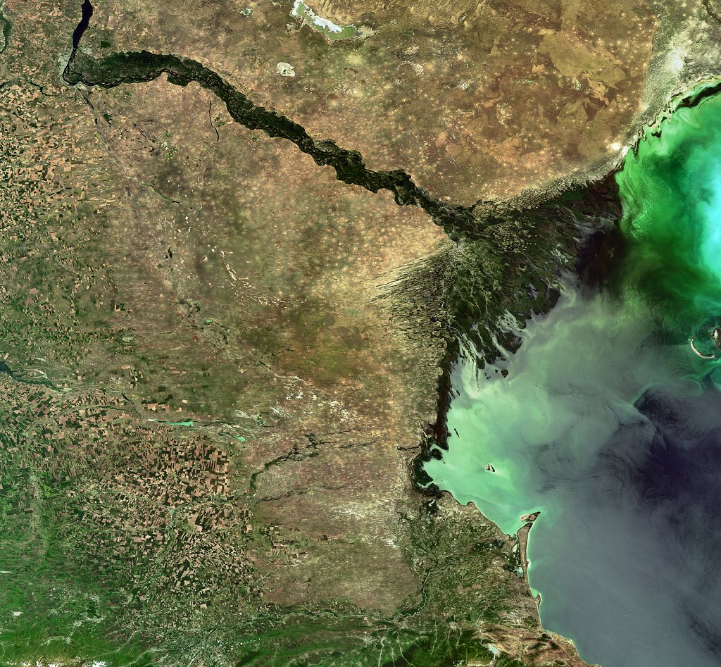
The team particularly highlighted losses from Russia's Volga River, the longest river in Europe, which supplies roughly 80% of the Caspian's inflow.
To find out why the Volga is discharging less water into the Caspian Sea now than it did 30 years ago, we spoke with Amir AghaKouchak, a co-author of the study and professor of civil and environmental engineering at the University of California, Irvine.
AghaKouchak, who directs UC Irvine's Center for Hydrometeorology and Remote Sensing, explained why river inputs have dropped and how decades of water withdrawals have put the Caspian Sea on a path to collapse. He also touched on a solution to this crisis — and revealed why Russia's hunger for ammunition to attack Ukraine is making it harder to save the Caspian Sea.
Sascha Pare: Falling water levels in the Caspian Sea have been attributed to natural variability, and more recently, there's been a focus on climate change and increased evaporation due to rising temperatures. But what did the results of your study show?
Amir AghaKouchak: People quickly jump to conclusions about climate change. Of course, that is important, but it cannot explain the change that we have observed. Over the last 30 years, water levels in the Caspian Sea have shrunk by around 2 meters [6.5 feet] or so. Just to put things in perspective, this translates to about 24,000 square kilometers [9,300 square miles] of sea area loss — about 5%. When we look at drivers, we notice that rainfall hasn't changed significantly over the lake and upstream, so the decline cannot be explained simply by changes in rain.
Evaporation has increased, so it explains maybe about one-third of the change. There is less water in the lake, and that indicates there's probably some water lost along the way. We don't have a lot of human-related data — for example, water withdrawal for irrigation or groundwater wells. That area is very difficult; the countries are not open to sharing data. A lot of our results are based on looking at proxies. Our interpretation is that temperature caused about 30% of the change and the rest is probably because of human activities.
SP: Which human activities does your research suggest are responsible for the Caspian Sea's decline?
AA: Several of the countries on the Caspian Sea have built large dams — Russia, for example. They are all desperate for hydropower. All of the countries around the lake [have also built infrastructure to supply agriculture], and one reason is that they want to create jobs and improve the local economy. Water demand is increasing in all those countries around the Caspian Sea. It's not surprising to see lakes drying or groundwater levels falling.
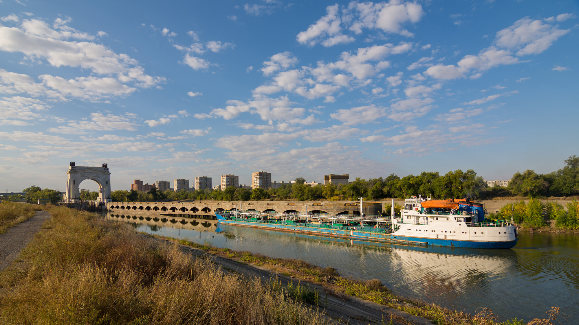
It's hard to find data about how much water countries are using; they keep data very private, especially places like Russia. We don't have detailed information, but the Volga-Don Canal in Russia is one of the projects that is contributing to this crisis. [Editor's note: The Volga-Don Canal is a ship canal that connects the Volga and Don rivers at their closest points.]
Opened in 1952, the Volga-Don Canal connects the Volga, which flows into the Caspian Sea, and the Don, which empties into the Sea of Azov (a northern extension of the Black Sea). (Image credit: Gaika102 via Getty Images)
But we cannot blame this whole thing on that. We have to be careful with our language; we can't say one project is responsible. Most likely, this is the collective impact of many different small withdrawals from here and there, overall contributing to a significant decline in the Volga River outflow into the lake. In the paper, we have different rivers, but the Volga dominates because it's the largest river. The Volga has a higher impact than all the other rivers combined. There are lots of demands along that river basin.
SP: Did you expect human activities to play such a big role, or were you surprised?
AA: We did not have any expectations at the beginning. In fact, when we started this project, I reached out to a lot of colleagues from neighboring countries around the Caspian Sea. We didn't want to do it on our own, sitting in California, looking at another area of the world, without having local people involved. If you look at the co-authors, you see people from Azerbaijan, Iran, Kazakhstan — so, we have local experts. We thought this was really important to have those perspectives. I didn't want to reflect the opinions of only one research group. What we have here is the collective opinion of people who have not met in person; we only exchanged emails to look at the results, and then we came up with those conclusions.
We do have a Russian involved, but not from an official Russian institution. I thought this was really important, because there's more back-and-forth [with a large group of people]. If two people have to convince themselves of an idea, it's much easier than with 20. Also, we brought in people from other countries who had projects in the area; for example, there is one group from Finland and another group from Germany. We tried to come up with something that this large group of people could agree on. It was not easy, but it worked out.
The Volga River supplies roughly 80% of the Caspian Sea's inflow, but huge water demands have decreased its flow. (Image credit: ESA, CC BY-SA 3.0 IGO )
SP: What is the worst-case future scenario for the Caspian Sea if shoreline countries fail to decrease their water demands?
AA: My concern is that, in the same general area, we have the Aral Sea, which is now about 5% to 10% of what it used to be, and Lake Urmia, in northwest Iran, that has also shrunk really fast and is now very small, with low levels of ecological activity. So we have two smaller lakes in a very similar climate that, from an ecological perspective, are dead. Because we have seen those degrade, we have to consider that this is the worst-case scenario for the Caspian Sea, too.
The Caspian Sea is much, much bigger. I hope it doesn't happen, but it's on the same path. Again, it's much larger, so it would probably take 100 years [to shrink as much as the Aral Sea and Lake Urmia], even with the current trend. But because we have seen those lakes shrink really fast, it deserves attention. Due to the size of this lake, the potential impacts will be huge. Even if 20% of the Caspian Sea dries out, the consequences will be very significant. It would be a disaster.
SP: You mentioned that drying lakes can become ecologically "dead." What other impacts could the Caspian Sea's falling water levels have on the surrounding landscape and people?
AA: The lake's retreat will expose the lake bed, and because it's saline, you have all kinds of minerals that will be exposed. With the next strong wind, they will go into the air. The health impacts include respiratory diseases, and even eye diseases, that are linked to salt minerals in the atmosphere. Those are the immediate consequences. Additionally, those minerals can travel long distances. In general, salt deposition on agricultural land reduces productivity. It takes a while, but if those lands are exposed for a long time, this will have an impact on the agricultural sector in those areas, which means potential food security issues. We don't exactly know what those materials are on the lake bed, so it's hard to know precisely what the consequences will be.
There is also serious shipping happening in this region. Right now, most of the shrinking is happening in the Caspian Sea's northern part, which is shallower [than the rest of the lake]. The drop in water levels is about 2 meters, and you can imagine that if you have a port and water levels drop more, you won't be able to operate. You'll need to extend your shipping routes southward; you'll need to invest and spend a lot of money to use other ports and docking sites. We have evidence of that around the Aral Sea and also Lake Urmia. There used to be these docking sites and ports, but those are now far away from the water.
SP: What must bordering countries do to save the Caspian Sea and prevent these negative effects?
AA: Demand management is absolutely critical. Demand management doesn't get a lot of attention, because unlike big projects that make the news, management means you have to cut things and do things that people don't notice. Some people argue that politicians don't show a lot of interest in demand management, but it's something that we have control over. The technological opportunities are there.
But when you look at that area, there is a big war — so probably it's not the priority to invest in management. There are a lot of things that we don't talk about in the paper that are relevant. I recently learned through discussions with people from the region — this is something that came to us from co-authors and collaborators — that many countries in that area grow cotton, which uses a lot of water. It has a lot of applications, but apparently, one of them is military. Cotton is used to produce ammunition. Russia needs a lot of ammunition, so not only are they growing it themselves, but they also bought neighboring reserves from Uzbekistan and Kazakhstan. So now, even those countries have an incentive to grow more cotton. This is driving more irrigation, more groundwater extraction, more surface water depletion, and probably more impacts on the Caspian Sea.
This interview has been condensed and edited lightly for clarity.
Each year, tons of soil, silt and rocks flow into reservoirs in the U.S. and get stuck there, creating a "ticking time bomb" that threatens lives and livelihoods. According to a new study, around a fifth of the world's reservoirs are currently at high risk of filling with sediment, and by 2060, half could be inoperable as a result.
The sediment takes up space meant for water, putting additional pressure on structures that were not built to contain large quantities of sand and sludge. As the reservoir fills with the material instead of water, sediment-filled reservoirs pose a serious threat to water security and the safety of people living near or downstream of them — and as the climate changes, scientists expect the problem to worsen.
"We are losing storage space in our reservoirs faster from sediment accumulation than we gain space from new dam construction," Amy East, a geologist at the U.S. Geological Survey, told Live Science.
What is dam sedimentation?
Dam sedimentation is not a uniquely U.S. problem. Rain pulls sediment down slopes into waterways. Normally, this sediment would travel through the river system, shaping the water flow, creating habitats, and fortifying coastal wetlands and estuaries against erosion. In many parts of the world, this sediment is also a vital natural fertilizer for crops. But after a river is dammed, this sediment can collect in the reservoir.
A 2023 study published in the journal Science found that sediment buildup was the greatest threat to global water storage in existing reservoirs — even more than drought.
New research, which includes smaller reservoirs, has offered a more nuanced and concerning picture. In the study, published June 5 in the journal Nature Sustainability, researchers assessed the state of reservoir sedimentation globally. They looked at more than 550,000 reservoirs, most of which spanned less than 0.4 square miles (1 square kilometre). They found that almost 1 in 5 of reservoirs globally are at high risk of filling up with sediment.
The researchers found that sedimentation is eating into global reservoir storage capacity at about 7.3% every decade. There are 16 global hotspots that are at high risk of reservoir sedimentation, threatening water supplies to more than 2 billion people and impacting more than a quarter of global irrigated land. One of these hotspots includes the western U.S.
The authors found that sedimentation risk was especially pronounced in regions with dense small-reservoir networks supporting key crop systems.
"Without intervention, we project that, by 2060, more than half of all reservoirs could become functionally inoperable," the authors wrote. This includes more than half of all small reservoirs and more than a third of large reservoirs globally.
Where is it a problem in the U.S.?
North America has the second largest number of reservoirs, after Asia, according to the global survey. And at 7.8%, its sedimentation rate is higher than the global average, ranking it third after Oceania (9.9%) and South America (8.1%),
The U.S. is home to many small dams, said Matthias Kondolf, a geomorphologist at the University of California, Berkeley who wasn't involved in the study. "All the focus tends to be on the big dams, and these many, many small ones have been neglected," he told Live Science.
From the 1940s to 1970s, there was a big push by the U.S. government to build "farm ponds," he said. In western Oklahoma, for example, "all these dams are now filling up with sediment, and there's nothing in place to assess the safety of these features, which have now become threats."
Reservoirs in some regions are more at risk than others. The western U.S. is a natural hotspot because it has a steeper topography, meaning more sediment naturally ends up in watersheds, East, who wasn't involved in the new research, said.
And in areas where human activities like farming or logging disrupt the landscape, rainfall is likely to drag even more sediment into reservoirs, East said. "Those types of land use can create sediment-producing hotspots almost anywhere."
In California, for example, more than half of small reservoirs in maize-growing areas are filling up with sediment at a rate of more than 10% a year, which threatens local maize production.
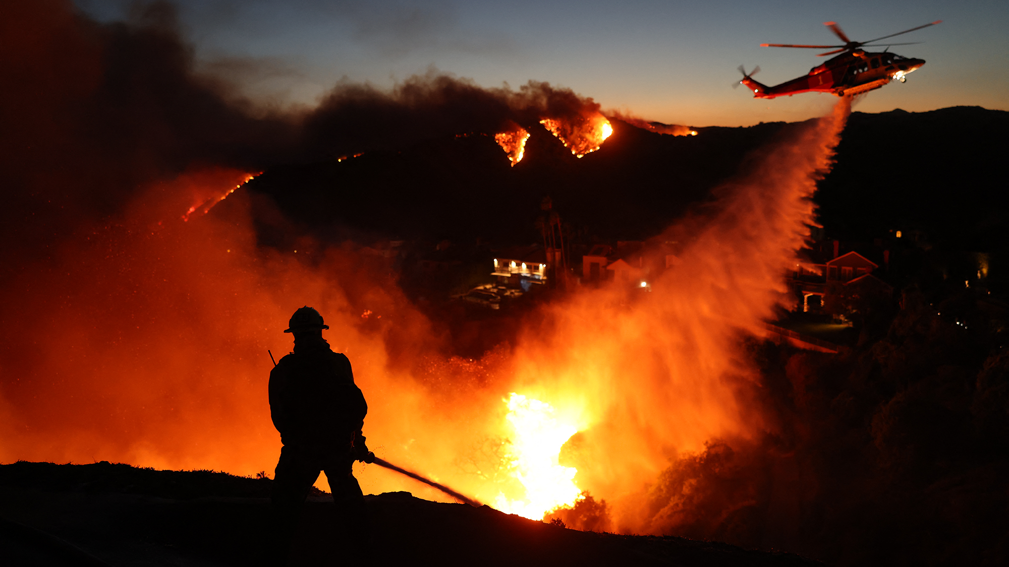
Wildfires also increase the amount of sediment flowing into rivers. (Image credit: DAVID SWANSON via Getty Images)
The threat to water security will be particularly acute in places struggling with wildfires, such as the western U.S. After fires, rain washes the debris and sediment into watersheds. A 2024 study in California found that most of this post-fire sediment erosion occurred upstream of reservoirs, rather than in places where sediment would move downstream directly to the ocean.
The dam-sedimentation situation is likely to get worse as the climate changes, researchers said. As the climate changes, there will be more extreme weather events, such as droughts and wildfires, adding more sediment to watersheds. Dams are designed to cope with the pressure of water, not sediment which exerts more force on dam walls. Moreover, in seismically active areas, the sediment vibrates at a different frequency than the concrete of the dam, which creates further impact against the structure. Additionally, the dams are just getting older.
"What do we do 50 or 100 years from now when we have all these reservoirs across the landscape filled with sediment, sitting there as ticking time bombs?" Kondolf said.
What can be done about it?
For a reservoir to be sustainable long-term, the amount of sediment entering it and leaving it should be the same.
"A big part of preventing reservoir sedimentation problems is upstream soil conservation in the watershed," East said. Interventions include ensuring that land use, such as agriculture or timber harvesting, follow best practice to reduce the amount of sediment washing off the landscapes.
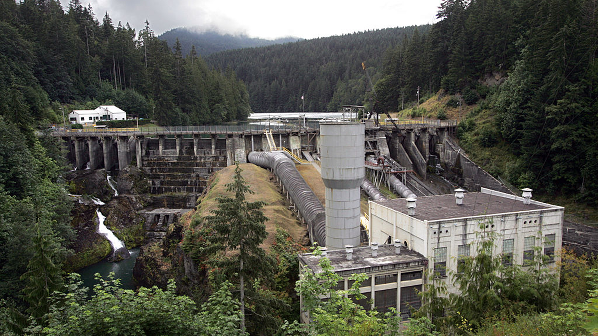
If sediment is already in the dam, it can be difficult to manage and expensive to remediate, Kondolf said. Some dams, such as Fall Creek Dam in Oregon, have mechanisms that enable engineers to release sediment. But in the past, reservoirs were not designed to manage sediment and little thought was given to how to decommission them.
"This is one of those issues that falls in the cracks between different agencies and responsibilities," Kondolf said. Some larger facilities fall under the remit of the federal government. Other dams fall under state governments. California, for example, recently launched a state-sponsored program to future-proof the state's dams.
But smaller dams often get overlooked, Kondolf said.
The Elwha Dam in Washington state which was removed around a decade ago. (Image credit: Tacoma News Tribune via Getty Images)
For smaller dams with a relatively small amount of sediment, "you just blow up the dam and let the sediment work its way downstream", Kondolf said.
There are other technological solutions, but they are expensive, such as retrofitting dams to enable them to pass sediment; creating a bypass to route sediment-heavy water around the dam; and mechanical dredging.
"The economics of managing reservoir sediment long-term were not generally incorporated into dam design and planning in the last century when many western-U.S. water projects began," East said. This has "pushed the cost burden on future generations."
But the reality is that reservoirs around the country are filling with sediment. It is reducing their ability to store water and potentially endangering the communities living downstream of them — and unless addressed, the problem will only get worse.
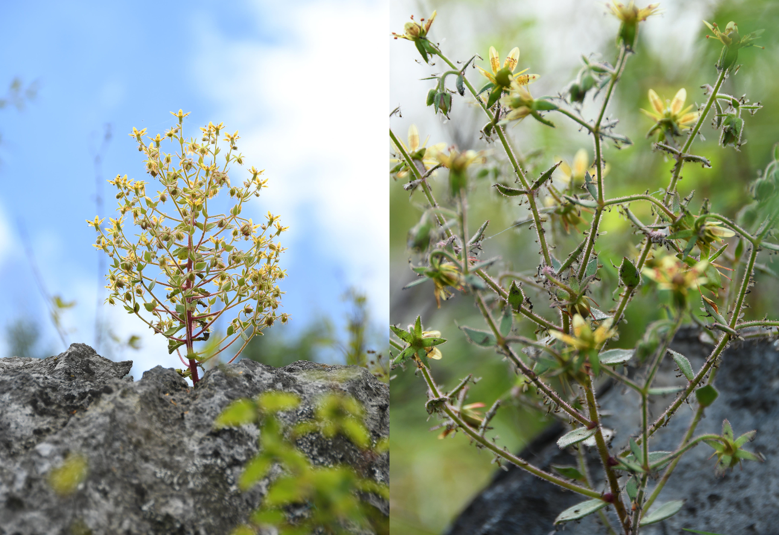
Scientists have confirmed that a flowering plant native to the mountains in southwest China is carnivorous, supporting a prediction made by Charles Darwin more than 150 years ago.
The species, Saxifraga candelabrum, grows at elevations above 8,200 feet (2,500 meters) in the Hengduan Mountains, which connect the southeast portions of the Tibetan Plateau to the Yunnan-Guizhou Plateau.
The plant has stems and branches covered in sticky hairs that can trap small insects, predominantly nonbiting midges. However, scientists were unsure if these insects were being ingested by the plant. In a new study, researchers showed that S. candelabrum can digest and absorb nutrients from insects after capturing them, proving that the plant is carnivorous. The scientists published their findings Tuesday (Aug. 4) in the journal Nature Communications.
This is the first demonstrated case of carnivory in the saxifrage plant group, said study co-author Douglas Soltis, a distinguished professor of biology at the Florida Museum of Natural History.
Other carnivorous plants typically grow in moist, boggy soils, but S. candelabrum is found in dry alpine areas, Soltis told Live Science in an email. "These are all nitrate poor soils — that's why this carnivorous habit has evolved a number of times" to supplement the plants in vital nutrients, he said.
In 1875, Darwin theorized that two species closely related to S. candelabrum that also have sticky hairs — S. rotundifolia and S. umbrosa — may be carnivorous, based on their ability to catch insects. But the 19th-century naturalist couldn't show that the plants digested their prey or reused the nutrients in insect tissues — two conditions that are key to confirming carnivory in plants. Without these conditions, a species is considered simply "protocarnivorous," meaning it catches and kills insects or other small animals but doesn't digest or absorb them, according to the study.
"Although untested at the time, Darwin’s hypothesis provided an important inspiration for our study," study co-author Hang Sun, a researcher in the Chinese Academy of Sciences' Kunming Institute of Botany, told Live Science in an email.
The researchers conducted field observations and herbarium surveys of S. candelabrum, which revealed that mature plants with more numerous and longer branches had an average of 71 trapped insects on them. In the herbarium surveys, the team found that 43 out of 45 specimens had caught insects, suggesting that insect-trapping is a widespread phenomenon in this species.
Next, the study's authors showed that S. candelabrum possesses phosphatase, a digestive enzyme commonly found in carnivorous plants. They did this by labeling the phosphatase enzymes with fluorescent molecules to visualize them under a specialized microscope, a technique known as fluorescence tagging.
S. candelabrum secretes a viscous substance that coats its hairs, meaning insects get stuck on the stem and branches if they fly too close. (Image credit: Xin-Jian Zhang)
To determine if S. candelabrum digests and absorbs nutrients from insects, the researchers labeled fruit flies with a stable form of nitrogen before feeding them to the plants. This led to a marked rise in stable nitrogen in S. candelabrum and in a different, known carnivorous species, which the team used as a control group. By contrast, a non-carnivorous plant that formed a second control group did not show an increase in stable nitrogen, indicating that S. candelabrum is carnivorous.
Finally, the researchers performed a genetic analysis, which revealed that S. candelabrum has genes in common with known carnivorous plants that are linked to prey attraction, digestion and nutrient absorption. Together, the results showed that S. candelabrum evolved carnivorous traits to cope with its nutrient-poor environment, adapting its hairs — which were initially used for herbivore defense — into insect traps, according to the study.
Larger insects, which S. candelabrum requires for pollination, rarely get stuck to the hairs, the researchers noted in the study, suggesting that the species has perfectly balanced its needs through evolution.
Other Saxifraga species and plants belonging to the same lineage could turn out to be carnivorous, too.
"Many members of the Saxifragaceae, which includes genera other than Saxifraga, have sticky glandular hairs and are often covered with insects," Soltis said. "I would not be surprised if other members of the family are also carnivorous — as Darwin predicted."
The study broadens the scope of carnivorous plant research, Sun said. "Carnivory may therefore be far more widespread among flowering plants than previously recognized," he said.
Forecasters are warning that the ongoing El Niño is likely to become supercharged in the coming months and inject potentially unprecedented heat into our already warming world.
El Niño is the warm phase of a multiyear natural climate pattern, but models suggest this year's cycle will be exceptionally intense. Super El Niño conditions could contribute to temperature extremes until next year, but scientists are warning that it may also pose longer-term threats.
Jong-Seong Kug, a professor in the Department of Earth and Environmental Sciences at Seoul National University in South Korea, uses observational data and artificial intelligence to model El Niño events.
Kug has found that super El Niño events can drive sudden, dramatic and even irreversible climate regime shifts. Live Science spoke with Kug to learn more about climate regime shifts and the long-term threats posed by this year's ongoing El Niño.
Patrick Pester: Last year, you published a study that found super El Niño events significantly increase the likelihood of potentially irreversible climate regime shifts. With a super El Niño now looking very likely, how concerned should we be?
Jong-Seong Kug: We should be concerned but not alarmist, because our study does not suggest that every super El Niño inevitably causes a climate regime shift. Rather, a super El Niño can push an already-stressed climate ecosystem across a critical threshold. If a system is near a critical threshold, then strong forcing can induce irreversible change.
Current forecasts indicate a very strong El Niño is increasingly likely later this year. We need to watch vulnerable regions closely, particularly those that are already experiencing severe warming, drying, ecosystem degradation or ocean stress.
PP: What kind of climate regime shift do you fear most?
J-S K: I am particularly concerned about the persistent shift in major ecosystems, such as the Amazon rainforest moving toward a much drier and degraded state. You know, a long time ago the Amazon was a savannah area, so we are now approaching this kind of tipping point. Also, in the Amazon, this drying can weaken [or] even reverse the forest's role as a carbon sink.
The Amazon is a carbon sink, but imagine it becomes drier and drier, and there's some die-back of the forest. Now, [carbon] sink becomes source. This could amplify global warming long after an El Niño event.
PP: Is there anything we can do to mitigate the threat of extreme climate and weather events in the coming months?
J-S K: We cannot stop El Niño. But we can greatly reduce its human impact or ecosystem impact. Governments should use precision forecasts to strengthen our heat health plan, water and food management and flood and wildfire preparedness. In the long term, a rapid reduction in greenhouse gas emissions remains essential because every additional degree of warming increases this possibility that an extreme natural event will trigger lasting damage.
PP: Do you think a reduction in greenhouse gas emissions is likely, given where we are now?
J-S K: I don't think so. It's very difficult.
PP: So, where does that leave us?
J-S K: I don't know. There are some additional techniques we may use at a critical point. Have you heard about climate engineering? Like stratospheric aerosol injection [reflecting solar radiation back into space]. If we cannot do anything, then we have to choose that kind of technology. I don't want this kind of situation, but maybe in the near future we have to decide.
There are two kinds of climate engineering. One is carbon mitigation, just direct air capture [taking carbon out of the atmosphere]. That is a safe way. The other is solar energy management. We can deflect more solar energy from the surface.
So, the easiest way is just to inject an aerosol into the stratosphere; then this aerosol reflects solar radiation, and then global temperatures will decrease. It's like a volcano: After a big eruption of a volcano, the global mean temperature drops by about 0.6 degrees [Celsius, or 1 degree Fahrenheit] because there is volcano aerosol [in the atmosphere]. Instead of volcano aerosol, artificially we can inject aerosol into the stratosphere. Then global temperature can easily decrease.
But there are many side effects. Some we already know, but some we don't know. Like climate inequality. If we artificially decrease temperatures, then some countries will have a drought or a flood. And then how will we compensate?
Obviously, if you want some kind of climate mitigation, we need a kind of consensus across the countries.
PP: Is there anything else you'd like to add that we haven't covered?
J-S K: This year, super El Niño is developing in an already exceptionally warm climate. We are already seeing widespread heat waves this year, so we cannot attribute every individual event to this El Niño. But El Niño will intensify toward the end of this year, so it is likely to further increase the risk of extreme events in many regions, so we need to prepare.
Editor's note: This interview has been edited and condensed for clarity.
What's in the photo? Lake ice fracturing along a disputed border between China and India
Who took the photo? An unnamed astronaut on board the International Space Station
When was it taken? Jan. 25, 2024
This eye-catching astronaut photo shows the fractured surface of the world's highest frozen lake lurking in the lofty climbs of the Tibetan Plateau. The smooth, white line where the ice meets the water closely follows a disputed border between China and India.
The elevated lake, known as Pangong Lake or Pangong Tso, sits at an altitude of 13,862 feet (4,225 meters), according to NASA's Earth Observatory. It is long and thin, stretching 83 miles (134 kilometers) across Ladakh, part of the Kashmir region administered by India; and Tibet, an autonomous region of China.
This photo shows a roughly 9.5-mile-long (15 km) section of the river, located around a third of the way along its length from west to east. This is also where the most widely accepted border between Ladakh (on the left of the photo) and Tibet (right side of the photo) lies. However, the exact position of the divide, commonly known as the Line of Actual Control, is poorly defined and has shifted in recent decades, according to The New York Times.
Pangong Lake is endorheic, meaning it has no outflow, and the only way water can escape is via evaporation. As a result, the lake's waters have built up an unusually high concentration of salt over thousands of years. This would usually prevent it from freezing. However, the temperature in the region can drop to minus 13 degrees Fahrenheit (minus 25 degrees Celsius), according to a local travel site, which is cold enough for the salty water to freeze over.
It is unclear why the lake's ice is fracturing in the photo. Normally, the entire body of water is completely frozen in January, when this photo was taken in 2024.
Pangong Lake largely freezes over between December and February, despite its high salinity. This image was captured in April 2025 and shows winter ice melting in another section of the lake. (Image credit: Matt Hunt/Anadolu via Getty Images)
Although Pangong Lake has no major outflow, it is connected to several inflowing rivers, including one on the bottom left of this image. The river's delta has largely frozen over (visible as the large, white patch on land), but you can still see a small plume of water entering the river.
On the opposite bank of the delta, there is a beach littered with several striations parallel to the water. These are ancient shorelines left over from when the lake had a higher water level, according to the Earth Observatory.
Pangong Lake was likely once part of the Indus River, which stretches nearly 2,000 miles (3,200 km) across South and Central Asia. However, it was likely cut off from the waterway millions of years ago as the Indian and Eurasian tectonic plates collided and the Tibetan Plateau and Himalayas formed.
Disputed border
The Line of Actual Control was first established in 1959 but was largely set in its current position in 1962 after the Sino-Indian War. Although the countries have technically been at peace ever since, frequent and occasionally deadly skirmishes have broken out along the border, including on the shores of Pangong Lake, according to the BBC.
Pangong Lake stretches 83 miles (134 km) across Ladakh and Tibet. An orange box highlights the rough location of the close-up astronaut photo featured above. (Image credit: NASA)
Nonetheless, the lake frequently draws tourists from both China and India, particularly bird-watchers, who travel there to see the large groups of bar-headed geese (Anser indicus) and Brahminy ducks (Tadorna ferruginea, also called ruddy shelducks) that breed there, according to the Earth Observatory.
On the Ladakh side of Pangong Lake, extreme-sports enthusiasts run long distances across the lake's ice. In February 2023, dozens of runners gathered there to participate in the highest-altitude frozen lake half-marathon ever recorded, according to Guinness World Records.
A 2020 astronaut photo shows three uniquely colored lakes — Tahoe, Walker and Mono — straddling contrasting biomes on either side of the California-Nevada border.
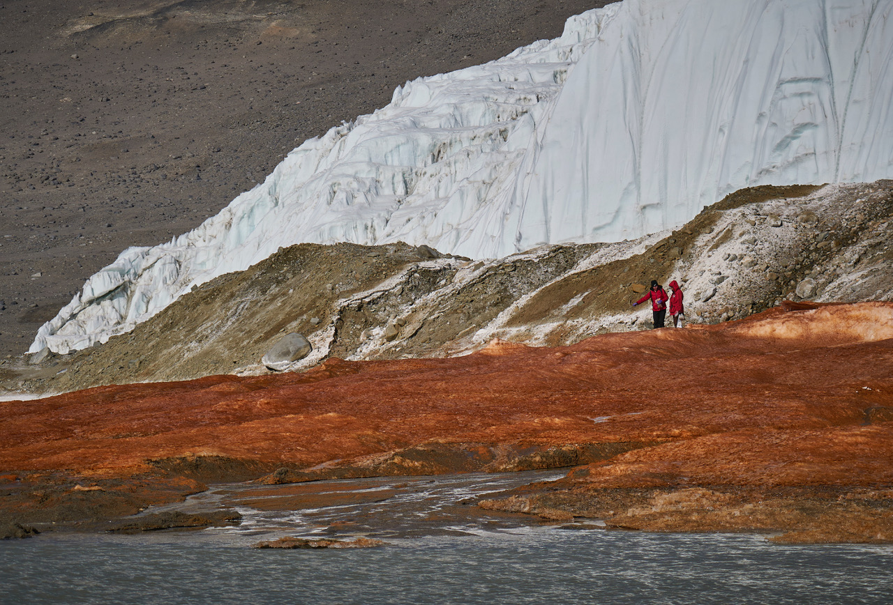
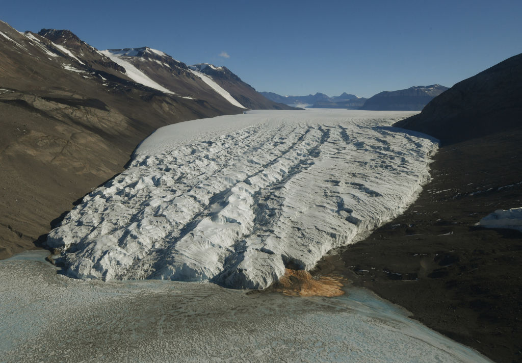
At the end of a glacier deep in East Antarctica's Taylor Valley, there is a haunting waterfall that oozes red brine like a bleeding wound in the ice. Scientists explained the brine's gory hue several years ago, finding that it is exceptionally rich in iron. And now, they may have identified the salty water's origin.
Microbes in the crimson waterfall, called Blood Falls, suggest the brine is composed of ancient seawater that was trapped in a pool beneath the glacier when ocean levels fell and the glacier advanced. However, it's unclear exactly when that happened, researchers noted. Previous studies had already proposed a seawater origin for the brine, based on various chemical signatures and bacteria detected in the liquid, but the new results add molecular and genetic evidence to the mix of clues.
"Findings in this study reveal a dominance of marine eukaryotic lineages in the Blood Falls area" compared with the broader region, known as the McMurdo Dry Valleys, the authors wrote in the study, published Monday (Aug. 3) in the journal Nature Geoscience. "This marine signal is less prominent but still detectable in the prokaryotic structure," the researchers added.
Eukaryotes' cells contain a membrane-bound nucleus and other closed internal compartments. Prokaryotes, by contrast, are single-celled organisms whose DNA floats around freely in the cell, unbounded by a membrane.
To characterize the types of microorganisms present within Blood Falls, the researchers used a suite of genetic techniques to analyze 167 samples of water, sediment and air from around the falls and the broader McMurdo Dry Valleys.
Some researchers argue that Blood Falls' water does not originate from seawater, and suggest the marine bacteria and chemical signatures that point to seawater may have instead reached the falls from the ocean via intense winds, which are common in the McMurdo Dry Valleys. By analyzing samples from various sites in the Dry Valleys, the team behind the new study compared microorganisms from the wider region with those at Blood Falls to determine if Blood Falls has a distinct microbial assemblage potentially left over from ancient conditions.
The researchers found that the crimson brine and associated red-tinted sediments at Blood Falls shared a higher proportion of eukaryotes with nearby oceanic samples than other sites in the Dry Valleys did. Whereas Blood Falls had a little over 9% of its eukaryotes in common with the ocean, the Dry Valleys showed only about 1% similarity, according to the study. The remaining eukaryotes and most of the prokaryotes identified in the paper had freshwater and terrestrial origins.
Researchers tried to determine if microbes at Blood Falls are distinct community from the surrounding region's assemblages. (Image credit: Bryan Minnea)
The results also showed that the air near Blood Falls contained only a tiny proportion of marine microorganisms, suggesting that present-day winds can't fully explain the microbial composition of Blood Falls, the researchers wrote.
The most likely origin for the brine that feeds Blood Falls is ancient seawater that was trapped when sea levels dropped and the Taylor Glacier advanced, the study found. (Image credit: MARK RALSTON/POOL/AFP via Getty Images)
Therefore, an ancient seawater origin is the most likely explanation for the microorganisms found at Blood Falls today, the team concluded. Winds may have played a role in shaping the community in the past, but now, their influence is probably insignificant, the team added.
The brine that feeds Blood Falls may have become entrapped more than 1 million years ago, during a warm period with higher sea levels and less ice cover than there is now, previous estimates suggested. However, further work, including more comprehensive genetic profiling and mapping of microorganisms, is needed to pinpoint when Taylor Valley's glacier grew to cover the brine, the researchers wrote.
Antarctica quiz: Test your knowledge on Earth's frozen continent
Aspen trees could provide a natural buffer against wildfires, as new research shows that areas of forest where these trees dominate burn less intensely than those made of conifers.
The findings suggest that planting more of the right kinds of trees, such as trembling aspen (Populus tremuloides, also known as quaking aspen), could be an effective strategy for protecting communities as devastating wildfires become more common and intense in a warming world, researchers reported June 15 in the journal Forest Ecology and Management.
Individual aspen trees burn easily because of their thin bark, but large "stands" — contiguous communities of trees that are uniform in species, age and structure — of them are more resistant to fire than stands of conifers and can act like a firebreak.
The reasons for aspen stands' resilience are not certain. However, researchers think it likely stems from a combination of factors, including the high moisture content in the aspens' leaves and the undergrowth, the trees' lack of highly flammable resin, and the leaves' height, which makes it harder for fire to spread to the canopy and leap from tree to tree.
Flavie Pelletier, who conducted the research as part of her doctorate at McGill University in Montreal, wanted to see whether aspen stands have been able to maintain their fire-resistant properties as climate change makes fire seasons more intense and destructive.
She combined new maps of dominant tree species in forests across Canada with satellite maps of wildfires from three recent years, including 2023, which was the country's most destructive wildfire season ever recorded. She noted which tree species tended to be inside the fire zone and which were more common at the edges. She found that aspen trees were more than twice as common at the perimeters of fires than inside them, while conifers like spruce and pine were equally present in both locations.
Having more aspen trees in a particular area also decreased the amount of forest that burned each day during a fire, so it also appears to help slow the spread of the fire. Notably, the trees still resisted fire spread even in the spring, before their leaves had fully sprouted.
"This is proof that aspen has an impact on fire perimeter formation and can slow fire progression," she told Live Science.
Anthony Taylor, a forest management specialist at the University of New Brunswick, said the study, with its use of large datasets on real fires, does a good job of analyzing and quantifying a phenomenon that Indigenous peoples and foresters have understood for a long time.
"The idea that deciduous trees burn less has been known for millennia, but knowing something through experience is different than testing it," he told Live Science.
Aspen trees in Vail Colorado. (Image credit: Getty Images)
Changing practices
The research supports the idea that planting aspen or other deciduous trees around vulnerable communities can help protect them from fires. Taylor said this buffer strategy is being considered or implemented in many areas.
A single line of trees will not do the trick. The stands must be deep enough to stop the flames from blowing over the top — probably 300 to 1,000 feet (100 to 300 meters), Taylor said.
Aspens can also play a role in fire control at larger scales. Pelletier first became interested in this topic when she learned that forestry companies often spray the forests they manage with the herbicide glyphosate to kill deciduous trees like aspen so they can grow monocultures of more economically valuable conifers, leaving those forests at much higher risk of fires. She hopes her work will help convince the companies and regulators to change their practices.
"There needs to be less of a war on aspen in commercial forests," she said. In the long term, it would actually benefit the companies, because it would reduce the risk of losing large numbers of trees to fire, even if it slightly reduces the value of the forest in the short term.
Taylor agrees that in places like New Brunswick, a province with a large forestry sector, officials should be promoting more mixed and hardwood forests, and less of the softwood monocultures that the forestry industry relies on.
"That would go a long way to making our landscape more resilient to wildfire," he said. "And that's what would have been here anyway, before we started converting the forests to a more industrial forest."
Climate change's impacts are being felt everywhere, from health and food security to extreme weather, sea level rise and collapsing ecosystems. World leaders have been slow to adapt to the warnings, despite an ever-growing body of evidence showing the compounding risks of greenhouse gas emissions.
But despite fossil fuels remaining the world's primary source of energy and emissions continuing to rise, there are changes afoot.
In his book "Despite it All" (Granta, 2026), author and journalist Fred Pearce looks at the shifts that have taken place over the last 40 years, highlighting how far humanity has come in the green transition. He believes this progress gives us reason to hope that we can eventually overcome the challenges we face today.
Pearce spoke with Live Science about his book, which has been shortlisted for the 2026 Royal Society Trivedi Science Book Prize.
Hannah Osborne: There are a lot of positive environmental stories throughout the book, including those that aren't necessarily being told. Do you think that there is a growing appetite for positive climate news now? And will it help us?
Fred Pearce: I detect a kind of desire to be told something other than it's all hopeless and there's nothing we can do. Some people are therefore saying, "Well, what can I do?" And they're very sort of personal stories about how they can contribute. But also people who think more, if you like, strategically: What can the world do, what can governments do, what, how can we influence that?
I try not to write what I think people want to read. I try to write what I want to say. And it seems to me that we do so many things so badly, whether it's managing our resources or water or handling forests or the climate, or pollution or whatever. We do things so badly that there is a great deal of scope for doing things a lot better. So, we need optimists and we need pessimists. We need pessimists to point out the problems. We need optimists to come up with some solutions or suggest where [there are] half open doors that we can push open.
I wrote this book in that kind of spirit to say "Look, yes, things are bad, yes, I'm not denying that they're bad, but there's an awful lot that we can do about it and in some cases are doing about it." That then divides into whether we're talking about human activity, our technical solutions to climate change. Tech fixes are good, not bad, which is something that can be a hard sell in the environment community sometimes, so I want to stress that.
I went to the Earth Summit 30 years ago where they agreed [upon] the original climate change convention. Back then they said we [need to] prevent dangerous climate change, but they really didn't know much about how to do it. Wind turbines were just, you know, a few masts on a hill in California. Nobody was dealing much in solar power because it was just so expensive. It had been developed for powering satellites and electric cars. Nobody was talking about [it].
We have made quite a lot of progress and it's not fast enough and CO2 emissions are stable, they're not going down. We need to do a hell of a lot more and we may have passed climate tipping points. I'm not denying any of that, but rather than throwing up our hands or saying it's hopeless, let's get on with the tech, let's also recognize that nature is very good at recovering. You destroy a forest, a rainforest, it doesn't mean that it's destroyed forever. It will, given the chance, come back if we give it room. So let's give forests room to recover.
In large parts of the world it's already happening — in Europe, even in North America. Agricultural land is being abandoned, and when it's abandoned nature comes back and not necessarily in the sort of ways that we might think. But nature does come back, stuff regrows. We can see how evolution is being kickstarted, if you like, by the chaos that we're creating. That's not to say we shouldn't stop creating the chaos, but we can see how nature recovers.
These are things that we can recognize and respond to; giving nature room to recover, rewilding projects, therefore I'm all in favor of [them]. We're not rewilding where we're trying to garden nature to get back to some sort of perfected past, a pristine system where we thought that everything was great — pre-industrial revolution or before Europeans arrived in North America or whatever it might be. But, we can give nature room to evolve and adapt and change. We can see that nature's doing that all the time, with or without climate change and with or without humans. Nature is constantly, if you like, remaking itself.
I'm not saying nature always comes back in ways that we approve of. Let's recognize the distinction between our sort of slightly romanticized idea of what nature should be and what nature actually is.
HO: You talk about rewilding and letting nature take its course, but how do humans fit in with this? Can we adapt our own perceptions of what nature is allowed and what's not?
FP: I think we can probably forget about what's allowed and what's not. Nature will do what it wants to do. We pride ourselves on our ability to garden nature in a way, or manage ecosystems. We're not really very good at it. Nature will very often take over and do what it wants to do.
Some of the world's biggest rewilding projects have gone quite badly wrong because we haven't quite thought it through. The one I'm thinking of really is the large project in the Netherlands where they're trying to sort of recreate ancient European ecosystems and they ended up with mass deaths of animals because their conception of the ecosystem didn't quite figure out. They then largely abandoned the project because they didn't like to see large numbers of animals dying.
A hardline rewilder would say let nature take its course. I see the case for that, and often I would support that, but we have our own sensibilities and our own concerns and we are living in a world where we are very much in charge of what's going on. So while I'm in favor of standing back and letting nature take its course, we have our own sensibilities, and it's not wrong for us to want to intervene sometimes.
The UN International Conference on Population and Development in Cairo in 1994. (Image credit: Getty Images)
HO: There's a chapter on human population and fertility rates, and how this is very much a climate change story as well. We're now seeing a lot of the rhetoric around this, and rights being stripped back and taken away. What's it like for you, having seen the changes from the UN International Conference on Population in Mexico in the 80s, to Cairo in the 90s to now?
FP: It's an extraordinary story. I've been working on these issues for 40 years now so I've seen a number of changes. Some of the changes I've seen are how technical fixes somehow became a reality when they seemed very distant a while ago.
But our perceptions change too on many things. We are, in many ways, more attuned to environmental issues now than we were 30 or 40 years ago. One of the big changes that I've seen is the notion of the population bomb, which for much of the 20th century was seen as the number one issue. People would say, "Well, there's no point in fixing the climate, there's no point in reducing our pollution because there are more and more people on the planet, and we're kind of doomed for that reason."
Well, it hasn't [happened]. When I went to my first international conference, which was the UN Population Conference in Mexico City in 1984, that was all the rage. They gave the UN Population prize to the mastermind of China's one child policy, which — in terms of human rights and what I would regard as acceptable human behavior — was dreadful. But such was the concern about population issues that they wanted to give a prize to the operator of that program.
A lot has changed. A feminist agenda, if I could put it that way, and I would say that approvingly, has taken over in reproductive politics. I saw it at a UN population conference in Cairo in 1994, 10 years after the Mexico event, that we need to assert reproductive rights. Many environmentalists said that's a cop out. It was all "it's feminist perspective, but it's dooming us."
Well, it didn't, because what we found was that by and large, women wanted to have smaller families because their children got to grow up. Medical improvements meant that you didn't have to have four or five children to secure the next generation. Two would usually do, sometimes you just wanted one. Women wanted to have lives outside the home. The population people seemed to be a bit surprised by that.
The environmental agenda was a very male-dominated one for a long time. So that came as a bit of a surprise, but the net result is that we've halved our fertility rates. They're more or less down to replacement levels [of reproduction] now globally.
I'm not just talking about Europe or North America. I'm talking about almost everywhere except Africa, and African levels have come down. Sometimes they're coming down to super low levels, so that people are now talking about not having enough babies and how we can encourage people to have babies. There are parts of the world where we're down to one child per woman and even a bit less.
My argument is that we need to carry on. Not take a sort of Elon Musk approach [or] send the women back to the home and [do] reproduction and that's what their job is. We need to complete the feminist revolution so that women have more rights, can make better choices, and indeed couples can make more and better choices about the family size that they want. We can arrange things so that it is possible to have children and a career, or make it easier to do that, and at that point probably reproduction levels will come back up.
What I'm really saying is that the agenda is now vastly different from what it was as recently as the 1980s and, and into the 1990s. The population bomb is being defused, to put it simply, there's a residual momentum effect which means that our numbers will carry on going up a bit. Sure, that creates strains on the planet, but we're not now talking about double the world population every 30 years, which is what was being talked about back in the mid 20th century. It's tailing off.
We now have, if you like, a consumption bomb more than a population bomb. The global issue is consumption in the rich world, and that's what's stressing the planet now — not too many babies in poor parts of the world.
It's important to level up, but also level down from the obscene riches that we see among a small number of individuals
HO: Inequality between the super rich and people in developing countries is becoming more and more stark. How do we bridge the gap to make sure there's a reasonable living standard for regular people without a huge cost to the environment?
FP: The truth is, and the numbers have been done by a number of different people, a reasonable standard of living for everybody on the planet is perfectly feasible without destroying the planet.
We need to do some things better, we need to have better technology, but for me, right up there with climate change is an issue of global inequality. When I was young, it was taken [that] inequalities were diminishing and it was taken almost as read that they would carry on diminishing, and a lot of aid policies were directed towards that. That's kind of disappeared since the sort of Reaganomics of the 1980s, all the changes in the finance system and perhaps the fall of the Berlin Wall, which meant that the sort of socialist or, or equality-based agendas collapsed politically.
We're now finding increased inequality, and that, it seems to me, is a threat to the lives of millions and billions of humans, but also to global stability and our ability perhaps to manage.
Serious global issues like climate change and many others are all undermined by the political stresses and economic stresses created by rising inequality. I see them going together.
It's also clear that it's important to level up, but also level down from the obscene riches that we see among a small number of individuals, who seem to be accumulating a greater share of the world's wealth, whether we're talking about dollars or natural resources.
HO: You have a whole chapter on renewables and how they're outpacing fossil fuels. They're the cheaper alternative. How do you see the political opposition to clean energy panning out over the next five to 10 years?
FP: It's fizzling out. It's a weird political backlash and yes, any big social trend or economic trend, they all have backlashes and it feels to me like this is it. What we see in the real world is that the U.S. — not just the U.S., but principally the U.S. — are in a state of near denial about climate and they're wanting to go back to fossil fuels.
In the rest of the world, if you look at it in terms of geopolitics of [the] U.S. versus China, then the U.S. is pushing this rather old agenda of fossil fuels, and China is absolutely going to reap the benefits in many, many ways in its drive towards renewables. China has been a really bad story in the past with its coal burning — and it's still building a few coal-fired power stations. But the really big story is how China has been principally responsible for bringing down the costs of renewable energy, particularly solar power.
You can now go to the most remote corners of rural Africa and you find people putting up their solar panels to recharge car batteries so that they can run their lights in the evening or whatever it is. And then you've got megacities operating using increasing amounts of solar power. India is getting on the bandwagon as well. It's got the fastest growing solar energy economy in the world.
In the real world, renewable [energy] is mostly cheaper than fossil fuels. It is also quicker to install, you don't have to build a huge power station, you can do it in bits and pieces, bolt bits on.
Yes, there are grid issues and they need to be addressed, and there are limits on operating. There are challenges, but renewables are just growing so fast, and it is growing so fast because it is so cheap.
And it's become so cheap, to put it very simply, because the Chinese 20 or 30 years ago decided this is what's going to happen. While everybody else was sort of talking about it and fussing about it and doing it in research labs, the Chinese kind of got to grips with it. I remember back in the 1990s talking about people who were going into China and coming back and telling me stories about how the Chinese are really serious about renewable energy. To be honest, I didn't quite believe them, but they were right, and 30 years on, the world is living with the benefits. That's true whether you're talking about Europe or rural Africa or big cities in Asia or wherever. It's coming.
There will be different solutions in different places and there are undoubtedly things that are harder to do than, you know, running our national grids on renewable energy, which is becoming really quite easy and something that everybody wants to do. The cement industries, fertilizers perhaps, some of these industries will take some more technical innovation. But it's happening, these are technical fixes that are working in the real world. Will we do it in time? Well, we're a bit late on the case, but we are on the case.
A large data center being built in Vernon, California. (Image credit: Myung J. Chun/Getty Images)
HO: We're now seeing a massive rise in AI data centers as well. Is this bad tech, shall we say?
FP: It's a serious issue. Partly because they're growing so fast — they can't just plug into the grid because the grid really can't deliver, so these companies are developing their own energy systems. Even in the U.S. they are very often renewable systems because they're cheaper. If you've got a data center out in Texas, then you're going to use wind power or solar power because it's cheaper and you're in control of it.
I suppose we reach a point where [we have to decide], do we want to reduce our use of energy or have almost as much energy as we want, but just green it and green it very fast. It is true that if all the renewable investment is going into electricity for data centers, that leaves less investment for other sectors of the economy, so I'm sure there are trade-offs, and I'm not saying that we should embrace data centers. But they can be a driving force for adoption of different forms of energy, renewable energy, and for perhaps changes in the grid systems as well.
I think we can have both. I think we need to have both because we're probably not going to stop the data engines, so we've got to find ways of greening them. There are issues and there are challenges ahead, and I don't want to diminish any of those, but you know, let's, let's be hopeful.
The title of the book uses the word hopeful rather than optimist because I don't want to sound Panglossian, but I do want to inject some hope.
HO: When you started writing the book, what did you hope people would take from it, and did that change after you'd finished?
FP: Well it kind of evolved. It began as an idea to sort of [be a] retrospective of my reporting, and then the publisher said, "Well, the story changes rather a lot along the way, so rather than just showcasing your reporting over 40 years, why don't you showcase the change, and be hopeful in the context of how things have changed over the last 40 years?"
That was [the] kind of starting point, and we sharpened up on it, as we went along it did become "Despite It All" and you know, the title is important, and not diminishing the "All." There's a lot of bad stuff out there, but despite it all we can have hope and we can find, develop and demand solutions.
HO: Did you find anything during the process of writing the book that surprised you?
FP: As I say, it started as a sort of retrospective project and going through it, [there were places I went years ago] and it did look bad, then I checked up on what had happened over the intervening years and suddenly things looked a lot better.
I went to Alaska and saw how the conflicts over managing caribou herds and the huge migrations that go on and it felt like that was doomed. I was talking to people who were hunting the animals and they were trying to protect them because they wanted to hunt them, therefore they wanted them still to be there, which is kind of counterintuitive for many environmentalists, but you know, they were the best defenders of the caribou because they ate them.
But it felt doomed, and yet 20 years later I checked out the numbers and the population of that herd has doubled and tripled. So stuff does happen and I suppose my surprise was how much good change I found when I looked into it further. Maybe that's me being better at looking for good news stories. I've written quite a lot of "bad news" books over the years and done a lot of "bad news" journalism over the years, so I certainly don't discount that. But if you step back and you think, well did good stuff happen? Well, yeah, sometimes it did.
The bison herds are coming back on the plains of parts of North America, if you go to Montana. The ranches are disappearing and big areas are being set aside for bison, and I've been seeing how farmland in parts of southern and eastern Europe has been abandoned over the years. It's not necessarily good news that we're abandoning farmland, but again, the way that nature comes back and woodlands are growing, there are more forests in Europe than there have been for probably centuries.
There's a lot of bad stuff to say. But it does seem to me that we have to not just cling onto, but embrace good stuff and try [to] take it forward.
Something I really hadn't thought about till I went back was what were the big issues in the 1980s, 1970s when I started out. Well, all our industrial rivers in Britain were filthy. Now our industrial rivers are relatively clean. It's our agricultural rivers that are filthy, so, I mean, there's been a big change there.
Nobody has to talk much about the ozone layer now. That was the number one issue in the mid 1980s, and the absolutely terrifying prospect if we hadn't fixed that. But it's been fixed.
We banned the chemicals that were doing it.
Remember acid rain, lead in petrol. They were hot topics, headline news, part of the rise of the environmental agenda in the 1980s — and they're the ones that we don't have to talk about anymore.
Now we're talking about climate change. I think there are other things coming up. I think the issue of nitrogen pollution is a fast growing one, and we need technical solutions to that.
The green revolution of crops, the high-yielding crops, which got us out of a cycle of ever worsening hunger and famines in the mid 20 century. That was a solution which created new problems. Those crops grew very well, but they required large amounts of inputs, including water, and water is now a growing issue — finding enough irrigation water, but also fertilizer and other agrichemicals. We're now reaping some of the bad effects of that, and we need to solve that. Scientists I know are working on, if you like, high-yielding crops that don't require so much fertilizer and don't require so much water.
It's doable because as I think I said at the start, we do a lot of things really very badly, but that does give us a lot of scope to do things a lot better, so let's get on with it.
This interview has been condensed and edited lightly for clarity.
Granta Books
Despite It All
In "Despite it All," Fred Pearce looks at the positive environmental changes that have taken place over the last four decades, from the defused population bomb to the unstoppable rise of renewables. While acknowledging there is still an enormous amount of work to prevent the worst impacts of climate change, Pearce shows there is hope for the future — HO
Biodiversity loss has been recognized as a threat to global stability for decades. The decline in overall diversity of species on our planet, either through extinction or a fall in abundance, can culminate in ecosystem collapse.
But in this excerpt from "Despite it All" (Granta, 2026), author and journalist Fred Pearce looks at the remarkable resilience of nature. If we can put aside our notions of what should and shouldn't be in a given environment and leave nature to adapt and thrive, we may begin to see the gains needed to support a healthy biosphere.
"Despite it All" has been shortlisted for the 2026 Royal Society Trivedi Science Book Prize.
If we are serious about rewilding, then we need to accept that it will take its own course.
Often invasive species are just the first stage of an ecological resurgence. They are the first movers, and their infestations are short-lived. In time, diversity usually returns — even if it's not always the same diversity as was there before. We should recognize that. We need to be as adaptable as nature itself, and jettison our more romantic notions about biodiversity and pristine environments.
So do many oldschool ecologists, says Chris Thomas, an ecologist at the University of York. They too often simply ignore any bits of nature that do not meet their expectations of what "should" be present. "The establishment of successful species in new locations is commonly interpreted as further evidence that the Earth's system is departing from a more desirable state," he told me.
So when biodiversity assessments are conducted, "alien" species lurking in the undergrowth are simply not counted. As outsiders, they are deemed not to belong to the ecosystem they inhabit. Thomas says that, in Britain, official records show biodiversity in decline, even though, if we add all losses and all gains together, "it is unequivocally true that the total number of species in Britain is increasing."
Most of the gains — the weeds, pests and alien species — are kept off the biodiversity books. This amounts to an ecological catch-22. Biodiversity can only ever decrease, as new species are seen as inimical to the local environment, and each year millions of pounds, dollars and euros are being spent to eliminate them.
We spend huge amounts of money trying to eradicate weeds, many of which may be beneficial for the environment. (Image credit: Catherine Falls Commercial/Getty Images)
Of course, it sometimes makes practical sense to eradicate invaders. I don't say we shouldn't try to keep out pests that cause short-term ecological mayhem and economic damage. But if we choose to get rid of new species, we can't then hold up our hands in horror at declining biodiversity. And besides, ecologically as much as socially, migrants can stir things up to good effect. They interact with other species — eating or being eaten, pollinating, and rotting after death to nurture new organisms.
We should embrace novel ecosystems that contain both what we regard as native species and the feral, opportunistic interlopers that find their new environment congenial. In his book about weeds, British naturalist Richard Mabey celebrated what he called these "outlaw plants" and showed how they have had a hand in shaping not only our landscape but our civilization, becoming crops, medicines and sources of beauty and creative inspiration.
It is easy to be nostalgic about past ecosystems as a golden age. But what we imagine to be the perfect ecological state — a supposedly natural order of things that often gets called "the balance of nature" — was mostly itself a passing phase. Nature is always moving on. And more often than we realize, humans have had a hand in what we now like to regard as natural.
We should be careful not to let our reverence for the pristine blind us to the environmental potential of today's wastelands
Environmental scientist Erle Ellis, who runs the Anthroecology Lab of the University of Maryland, argues persuasively that most of the planet has been heavily influenced by human activity for thousands of years, including places such as the Amazon that we often think of as untouched. We have, in effect, long lived on a "used planet," and humans and nature have not historically been at odds. The most biodiverse places are often those where people have lived the longest. By constantly tending the land, past civilizations created ever-changing mosaics of habitats where more species thrived than in places with less human interference.
So, we should be careful not to let our reverence for the pristine blind us to the environmental potential of today's wastelands, backwoods, abandoned fields, scrublands and no-go areas. In a Good Anthropocene we are likely to need more of them.
There is a final reason for believing that nature is equipped for recovery from almost anything we can throw at it. The apparent chaos of the Anthropocene is turbocharging evolution itself. Every perturbation of our environment creates an opportunity for existing species to adapt or for new ones to evolve, says Chris Thomas.
Plant evolution is happening at an increasing rate as species adapt to changing conditions. Allowing it to happen could help increase biodiversity. (Image credit: Rosmarie Wirz/Getty Images)
I first met Thomas in 2004, when he had just published an influential paper warning that climate change could wipe out a quarter of the world's species this century. He called it "terrifying." It was headline news. Two decades later, he has not changed that forecast, but he has added an important rider. Despite the coming extinction holocaust, he told me, "the Anthropocene could raise biological diversity."
His research is showing that evolution in the twenty-first century is speeding up to fill the gaps left by the extinctions — delivering new and better-adapted species. "The seeds of recovery are already visible," he told me. "Genes are jumping around. New species are beginning to emerge." Rob Dunn, an ecologist at North Carolina State University, agrees. In his book "A Natural History of the Future," he says that this evolutionary spurt is happening fastest in urban landscapes, where species are adapting to city life with almost as much alacrity as newly arrived humans.
This urban ecological renaissance resembles the story of the finches on the Galápagos archipelago, which Charles Darwin observed to have evolved different beaks to match the food on the different islands. In modern cities, house mice have evolved to produce saliva with a chemical make-up better able to digest the carbohydrates available in urban food; cockroaches and bedbugs have developed resistance to pesticides and even learned to avoid sugar-impregnated bait; London's pigeons have learned to commute on the Underground. We have clothes moths and carpet beetles.
Such natural innovations may not always be cuddly, but they do show that nature is on the prowl in the Anthropocene. So where is biodiversity headed? It is undeniable that most species of plants and animals are currently in numerical decline in a human-centric world.
This global disturbance is favouring some generalists — so-called superspecies — that can occupy a wide range of habitats, displacing local, rare and specialist species. Locally, however, biodiversity has sometimes increased substantially, especially in the rich kaleidoscopes of gardens, parks, toxic brownfield sites, roadside verges and so on that humanity has helped create.
Such places may become crucibles for a biodiversity rebound. Understanding this reality should change how we do conservation. We should not abandon nature to its fate. Some of our favourite species will pass into history unless we act to save them, and I'd vote for action any day. But it does mean embracing rather than rejecting the processes of change. Change in the Anthropocene is good. We should be grateful that nature is finding a way.
This is an extract from Despite it All by Fred Pearce, published by Granta.
amazon
Despite It All: A Handbook for Climate Hopefuls
In "Despite it All," Fred Pearce looks at the positive environmental changes that have taken place over the last four decades, from the defused population bomb to the unstoppable rise of renewables. While acknowledging there is still an enormous amount of work to prevent the worst impacts of climate change, Pearce shows there is hope for the future — HO
While millions around the world grappled with extreme heat this month, a research station in Antarctica recorded Earth's coldest temperature since 2012.
The high-altitude research station, named Concordia, logged a low of minus 119.4 degrees Fahrenheit (minus 84.1 degrees Celsius) on July 18, according to data from the station.
Concordia is located in the interior of the Antarctic continent, which is currently in the dead of winter with no sunlight. Temperatures at the station regularly fall below minus 112 F (minus 80 C) this time of year — so the new reading isn't unprecedented, but it's still significant.
"Even here, where extreme cold is expected, temperatures below minus 84 C are remarkable and highlight how variable Antarctic weather can still be," Gabriele Carugati, the station leader at Concordia for Italy's National Antarctic Research Program (PNRA), told Live Science over a video call from the station.
The French Polar Institute Paul-Émile Victor, which runs Concordia with the PNRA, sent Live Science raw data from July 18, which showed the temperature dropping to minus 84.1 C twice, at 6:25 a.m. and 6:34 a.m. local time.
The extreme chill at Concordia stands in sharp contrast to the sweltering heat that many countries are currently experiencing. North America and Europe have been battling heat waves this summer, with Western Europe recording the hottest June on record. Meanwhile, wildfires are raging in Canada, the U.S., France, Spain and other countries.
Globally, average temperatures are going up as humans pump more heat-trapping greenhouse gases into the atmosphere. However, Earth's weather systems are complex, and climate change doesn't mean that everywhere gets hotter all of the time.
"Climate change describes the long-term global trends, while individual weather events can still [bring] exceptional cold," Carugati said. "Antarctica is influenced by complex atmospheric processes, so an extreme low temperature at one location does not contradict the broader picture of global warming."
"Astronauts of ice"
Concordia is considered the most remote and extreme research station in the world. Built on top of a 10,800-foot-thick (3,300 meters) ice cap, the station is used for a variety of purposes, including seismic observations, astronomy and the modeling of Earth's past climates, according to the French Polar Institute Paul-Émile Victor.
"Concordia is a special place because it sits at over 3,200 meters [10,500 feet] above sea level on the Antarctic Plateau, and more than 1,000 kilometers [600 miles] from the coast," Carugati said. "During winter, there is no sunlight for months, the atmosphere is extremely dry and stable, and under clear skies, heat continuously escapes to space because there are no clouds, allowing temperatures to fall to extraordinary levels."
Concordia's environment is so harsh and isolated that the station is also used to improve our understanding of the physical, mental and social challenges astronauts experience in space. Carugati noted that the only person at the station who is not researching the environment is a European Space Agency biomedical doctor, who is studying the researchers who work there, nicknamed "astronauts of ice."
Planes can't fly to Concordia once winter sets in, and it's around 370 miles (600 kilometers) from the nearest research station. That technically makes crews more isolated than astronauts on the International Space Station, which orbits about 250 miles (400 km) above Earth, according to the European Space Agency.
What is the coldest temperature ever recorded?
The coldest temperature ever recorded at Concordia was minus 120.5 F (minus 84.7 C), logged in the winter of 2010, according to the Italian Antarctic Meteo-Climatological Observatory. However, another high-altitude research station in East Antarctica has the all-time record for the coldest temperature ever recorded on Earth. Russia's Vostok weather station, the nearest station to Concordia, recorded a temp of minus 128.6 F (minus 89.2 C) in July 1983, according to the World Meteorological Organization.
Satellite data suggests that temperatures can drop as low as minus 144 F (98 C) in East Antarctica, according to a 2018 study published in the journal Geophysical Research Letters. However, even though Antarctica is the coldest and driest continent, it's not immune to global warming.
Major glaciers and the ice sheet they support are at risk in West Antarctica, with the Antarctic Peninsula — which extends out of the western side of the continent — experiencing the most rapid warming. A study published in February in the journal Frontiers in Environmental Science found that decisions made on greenhouse gas emissions today will determine how much the peninsula will change in the coming centuries, with sea ice, ice shelves and glaciers, along with the penguins that live on them, at risk of disappearing.
Concordia sits on the largest ice sheet on Earth. This sheet in East Antarctica is more stable than the smaller sheet of West Antarctica, but it is still vulnerable to rising temperatures. An unprecedented Antarctic winter heat wave in March 2024 saw temperatures near Concordia rise to a record high of 15.1 F (minus 9.4 C) — about 32 F (18 C) warmer than the previous March maximum. This East Antarctic heat wave was amplified by global warming, according to a study published in April in the journal npj Climate and Atmospheric Science.
Earth recently entered an El Niño, the warm phase of a multiyear natural climate pattern, which could bring unprecedented temperature extremes to an already-warming world. Carbon Brief, a U.K. based outlet that reports on climate news and policy, has predicted that 2026 is likely to be the second-warmest year on record, behind 2024, with the intensifying El Niño increasing the likelihood that 2027 will be the warmest year ever recorded.
For now, at Concordia, the researchers are continuing their work in the blistering cold of Antarctica's winter. Carugati noted that the latest extreme-temperature data will inform forecasts and long-term climate monitoring.
"Extreme observations like this help scientists better understand atmospheric processes and improve the climate models," he said.
An ecological "superspreader" event may be imminent as more than 1,500 ships continue to idle in the closed Strait of Hormuz, with the potential to cause serious impacts for human health and global marine ecosystems, scientists warn.
In a study published July 22 in the journal Biological Invasions, scientists explain how the hundreds of stranded commercial vessels sitting idle on both sides of the strait are being colonized by marine microbes, algae, seaweed, barnacles and other invertebrates. The problem is that once these ships start moving again, these organisms will be spread all around the world.
"The unprecedented scale and duration of this spring and summer mass lay-up of large commercial ships has created ideal conditions for a marine invasive species 'super-spreader' event," Mario Tamburri, a professor at the University of Maryland Center for Environmental Science and first author of the study, said in a statement.
The Iran War is already having devastatingimpacts around the world. After the U.S. and Israel launched strikes on Iran on Feb. 28, Tehran retaliated by restricting shipping traffic through the Strait of Hormuz — a critical shipping route that connects the Persian Gulf and the Gulf of Oman and facilitates the transport of 20% of the world's oil supply, according to the U.S. Energy Information Administration.
But the economic impacts of the waterway's prolonged closure are only part of the story.
While it's common for cargo ships to linger for a day or two at most ports, the study authors say these organisms — which are arriving from all over the world and are now mixing and spreading among the other stationary vessels — really begin to flourish after about 10 days of inactivity.
When ships are idle for longer than 10 days, these organisms start to colonize "aggressively" as the special coatings that protect ships from contamination start to work less effectively, the researchers write. And once these organisms are brought into new environments, they can wreak havoc on local ecosystems.
"Marine invasions are hard to predict but it is possible for several species to establish themselves in new habitats and with some causing significant environmental and economic impacts," Tamburri told Live Science in an email.
Tamburri pointed to the example of zebra mussels (Dreissena polymorpha) in the Great Lakes. The mollusks, which are native to Europe and Asia, are thought to have been introduced to the U.S. in the 1980s via water discharged from large European cargo ships, according to the U.S. Geological Survey.
The impacts of these invasive animals are widespread: They filter out algae that native species need for food and attach to native mussels, preventing them from moving, feeding or reproducing, according to the National Park Service (NPS). They also clog pipes and water supply systems, which cost millions of dollars to fix.
Each female zebra mussel can produce thousands of eggs, so once populations are established, there is "very little" that can be done to remove them, the NPS notes.
In addition to outcompeting native species for space and resources, invasive species can spread disease.
"One of the less perceptible concerns from biological invasions is the potential spread of infective stages of parasites and diseases that are either entrained within ship ballast tanks or associated with organisms attached to ship hulls," April Blakeslee, an associate professor of biology at East Carolina University, told Live Science in an email. Parasites and diseases introduced by ships could then spill over to native species, which could affect ecologically and/or commercially valuable species, or possibly pose concerns for human health, Blakeslee added.
In other words, these species could spread diseases with the potential to infect local wildlife and humans, as well as fisheries and aquaculture.
Tamburri said the areas most at risk are first ports of call with similar temperatures and salt levels to the Gulf region, particularly ports in India, Singapore, Greece, Spain, the Netherlands and several ports in the Middle East.
So what can be done to stop this "superspreading" event before it happens? According to the researchers, cleaning ships in the water before they leave the Gulf region could significantly reduce the spread of these organisms. Estimating the risks posed by specific ships before departure and setting up monitoring networks and early detection systems at high-risk ports may also limit the damage.
"While the human and economic consequences of events like the war in the Middle East will always remain the highest priority, ecological impacts cannot be overlooked," the researchers wrote.
A powerful earthquake struck southwestern Japan Tuesday afternoon local time, collapsing part of a shopping mall, toppling a stone wall at the centuries-old Kumamoto Castle, and sending more than 150,000 people to evacuation shelters, the BBC reported.
The quake, which the U.S. Geological Survey (USGS) measured as a magnitude 6.8, hit at 4:27 p.m. local time near Kumamoto, a city of more than 700,000 people located on the island of Kyushu in southern Japan.
Thousands of homes lost power, and roads buckled across the region. The second floor of a shopping center collapsed, trapping shoppers inside, according to the BBC report; some of these people were evacuated and later hospitalized. A brief tsunami warning was issued and lifted within an hour.
A map showing the location of the July 2026 earthquake. (Image credit: National Tsunami Warning Center (ATWC), Pacific Tsunami Warning Center (PTWC), USGS National Earthquake Information Center, PDE)
The USGS measurement is different from the magnitude 7.1 reported by the Japan Meteorological Agency, "primarily because the agencies are reporting different magnitude types," the USGS reported. While Japan is looking at local magnitude, the USGS measured the moment magnitude, which is derived from the physical size of the fault rupture and gives the "most reliable estimate of earthquake size" for large earthquakes, since local-magnitude scales can lose accuracy once a rupture grows big enough, the USGS reported.
These measurements are helpful, as "different magnitude types capture different characteristics of earthquake source processes," the USGS noted. Local magnitude, for example, reflects how strongly the ground shook nearby, while moment magnitude reflects the total energy released across the fault.
Why this quake is scientifically interesting
Japan sits atop one of the most active plate boundaries on Earth, where the Philippine Sea Plate dives beneath the Eurasia Plate. That process, known as subduction, is responsible for the massive, tsunami-generating earthquakes that periodically strike offshore Japan, and it's been studied intensively for decades.
But Tuesday's earthquake didn't occur at the boundary itself. Instead, the rupture happened within the Eurasia Plate, more than 60 miles (100 kilometers) inland from where the plates meet, Jeffrey Park, a theoretical seismologist at Yale University, told Live Science. Roughly 90% of earthquakes happen at plate boundaries, where the constant grinding of two plates builds up stress until a fault gives way. Quakes that strike farther inside a plate — sometimes called intraplate earthquakes — are rarer and less understood, though scientists suspect that stress transmitted through the plate can reactivate old, dormant faults far from the boundary that produced it.
According to Park, the fault in Tuesday's earthquake moved in a way that suggests the plate tore horizontally as it was twisted by subduction occurring at an angle.
The USGS describes this event as shallow strike-slip faulting: the two sides of the fracture slid past each other horizontally, rather than one side thrusting up and over the other. This faulting style, combined with the shallow depth of just 6 miles (10 kilometers) down, points to the same type of rupture behind Kyushu’s deadly 2016 Kumamoto earthquake sequence.
That inland location is also why the quake didn't generate a damaging tsunami, despite the brief precautionary warning. Tsunamis are produced when a big event — such as an earthquake, volcanic eruption or landslide — displaces water; the force from that displacement then propagates as a wave.
Tuesday's rupture stayed entirely on land, so it never pushed the seafloor up the way offshore quakes do. That's why the tsunami risk stayed low, even with the brief precautionary warning. Still, an inland quake isn't automatically off the hook: if the shaking triggers a landslide that spills into the sea, that alone can generate a tsunami.
The depth mattered just as much as the location. The quake was shallow enough to concentrate its energy near the surface, which Park said explains the structural damage.
"Because it is shallow it will cause more structural damage than a similar-sized event that might occur deeper and offshore," he told Live Science in an email.
Earthquake country
Severalearthquakeshave already clustered in the area, and numerous aftershocks are expected over the coming days. Japan experiences roughly 1,500 earthquakes annually, making it one of the most seismically active countries on the planet — a byproduct of sitting at the junction of several tectonic plates.
To protect itself, Japan has spent decades — and learned from painful lessons from disasters like the 2011 Tohoku earthquake and tsunami — engineering a response system built for exactly this scenario.
Bullet trains are programmed to halt automatically the instant seismic sensors detect a major earthquake, a safeguard Park pointed to as a defining feature of the country's earthquake readiness. That automatic shutdown extends to other transit and utility systems, part of a broader early-warning network that alerts the public within seconds of a quake's detection, giving people crucial time to take cover before shaking arrives.
Japan's investment in its infrastructure may help to explain why, even after a magnitude 7 event near a city of 700,000, Japan's death toll and damage have historically been far lower than those from comparable quakes elsewhere in the world.
Search-and-rescue efforts are continuing in Kumamoto, with CNN reporting that between 20 and 30 employees remained unaccounted for at the Aeon Mall in Kashima Town, where the building’s second floor had collapsed. Firefighters were also working to reach the site and contain nearby fires.
What's in the photo? Folded layers of rock left over from an ancient continental collision
Which satellite took the photo? NASA's Terra satellite
When was it taken? April 11, 2011
This striking satellite photo shows a multicolor "fan" of folded rocks sculpted by a longtime collision between two of Earth's tectonic plates.
The geological feature, known as an imbricate fan, is located around 3 miles (5 kilometers) east of the town of Murgha Kibzai in Pakistan's Balochistan province. The photographed section of folded rocks measures around 9 miles (15 km) across, but the fan stretches up to 55 miles (89 km) from end to end, well beyond the area in this image.
The dramatic structure sits at an altitude of around 5,000 feet (1,500 meters) in the Sulaiman Range, a series of mountains that covers around 2,500 square miles (6,500 square kilometers) of Pakistan and Afghanistan. ("Sulaiman" means "of Solomon," in reference to the biblical figure King Solomon, and the range's largest peak is Takht-e-Sulaiman, which translates to "Throne of Solomon.")
This is one of several unique features that emerged along the boundary between the Eurasian and Indian tectonic plates, which have been colliding for more than 60 million years. At one point during this tectonic tug-of-war, the two plates became somewhat intertwined, allowing the fan to take shape, according to NASA's Earth Observatory.
"As India moved northward, it began to rotate in a counter-clockwise direction, wrenching the northwestern part of the Indian plate backwards into part of the Eurasian plate," Earth Observatory representatives wrote. "The countervailing forces put the rocks of the Sulaiman Range in a unique compressional vice, causing many of its faults to curve and stretch in convoluted ways."
The Sulaiman Range is full of unique geological features that were birthed by the collision between the Indian and Eurasian plates. (The imbricate fan is located on the far right of this wide-field image.) (Image credit: NASA/Terra)
The fan is made up of alternating layers of sandstone, which appear dark in the image, and limestone, which has a much lighter hue. These sedimentary rocks were formed by "thrust faults" that shot upward from the boundary between the Eurasian and Indian plates and became entangled as the boundary moved back and forth.
The satellite image is false-color, meaning it includes wavelengths of the electromagnetic spectrum that are not normally visible to humans. This helps to accentuate the differences between the two rock types, although they can also be easily distinguished with the naked eye. Pockets of vegetation appear in red throughout the image.
The photo is a small part of a larger, wide-field image (see above), which showcases several other intriguing geological features across the Sulaiman Range in false color.
Continental collision
The collision between the Eurasian and Indian plates became inevitable around 80 million years ago, when dinosaurs still ruled Earth, according to the Earth Observatory. At this point, the pair became locked on a collision course, with each plate moving more than 8 inches (20 centimeters) per year — around twice the speed of the fastest tectonic plates today.
Around 60 million years ago, the plates slowly slammed together. Normally, this would cause the smallest tectonic plate to sink below the other. However, the two plates' massive size meant neither receded. Instead, the continental crust along the boundary grew thicker, and the ground buckled, folded and pushed upward.
The Indian and Eurasian plates have been locked in a tectonic tug-of-war for more than 60 million years. Their collision birthed the Sulaiman Range, alongside the Karakoram and the Himalayas. (Image credit: Getty Images)
This process created not only the Sulaiman Range but also the Karakoram (a huge mountain range that spans the borders of China, India, Pakistan, Tajikistan and Afghanistan) and the Himalayas — the two tallest mountain ranges on Earth, according to the Earth Observatory.
This collision continued at full speed for around 30 million years, before eventually slowing down. However, the two plates are still technically colliding today, making the region a major earthquake hotspot.
A 2019 astronaut photo shows off ancient lava flows that once oozed down the jet-black slopes of the Toussidé volcano in northwestern Chad. An intriguing volcanic "skull" also lurks in the aerial image.
A 2025 astronaut photo shows a massif made of concentric mountain ridges in the Libyan desert. The rocky walls contain ancient artworks and are occasionally used to contain herds of grazing cattle.
What it means: A seamount is an undersea mountain that rises at least 3,300 feet (1,000 meters) above the seafloor but does not come close to breaking the surface. According to the National Oceanic and Atmospheric Administration, there are at least 100,000 seamounts in the oceans, and less than 0.1% of them have been explored. Seamounts typically form from volcanic activity, and many host dramatic communities of sea life — from coral, to sharks, to an assortment of weird jellyfish-looking things.
How to use it in a sentence: Every time marine biologists explore a seamount with their remotely operated vehicles, they seem to discover a new universe of strange and blobby deep-sea creatures.
Can you crack our science word of the day puzzle, Chain Word?
What it means: In Latin, "Pando" means "I spread." And boy, does it. Pando is a clonal stand of aspen trees in Utah that weighs about 13 million pounds (6 million kilograms), making it the world's heaviest living organism ever found. Its 40,000 trees cover 106 acres (43 hectares) in Fishlake National Forest, and they're all connected by a single, sprawling root system. Some DNA analysis suggests that this many-fingered megatree is tens of thousands of years old.
How to use it in a sentence: When you walk through Pando, what seems like a normal stroll through an aspen grove is actually a trip through a single, ancient living being.
Can you crack our science word of the day puzzle, Chain Word?

 Login