❌

Normal view

“Pluto Never Stops Surprising Us”: SwRI Scientists Find Evidence of Liquid Nitrogen on Pluto

7 August 2026 at 14:13

A Southwest Research Institute (SwRI)-led research team has discovered evidence of liquid nitrogen rising to the surface of Pluto through cracks in the dwarf planet’s heart-shaped glacier, Sputnik Planitia.

According to the researchers behind the detection, the liquid nitrogen evidence captured by NASA’s New Horizons Spacecraft is the first evidence of any liquid flowing on Pluto. They also suggest that the discovery could help scientists better understand other solar system features such as the geysers on Neptune’s moon Triton.

New Horizons Mission Gave First Hint of Liquid Nitrogen on Pluto

When New Horizons captured images of Pluto’s surface between 2015 and 2016, it gathered extensive imagery of a massive surface feature called Sputnik Planitia. Larger than Texas and Oklahoma combined, the frozen nitrogen lake has long fascinated planetary scientists.

When examining the spacecraft’s photos, researchers spotted thin, dark, linear features separating the city-sized geologic convection cells on Sputnik Planitia’s northernmost portions. Critically, the thinner, separating features were more diffuse than the larger ones. Although some previous studies suggested that Pluto may have a liquid water ocean beneath its frozen outer shell, the surface temperatures would prevent any of that water from flowing on the surface long enough to cause the features.

Some theories proposed a liquid nitrogen explanation for the thinner features, even though the research team behind the discovery said that Pluto’s atmospheric and thermal conditions make liquid rain physically impossible. Still, the team notes, the surface patterns on Pluto’s northern Sputnik Planitia “have been darkened in ways that resemble glacial features on Earth that have been wetted by water rain or the subsurface emergence of liquids to the surface.”

To better understand the data, SwRI Associate Vice President and principal investigator on the New Horizons mission, Dr. Alan Stern, reexamined the data, focusing on similar features on Earth.

Sputnik Planitia Evidence “Very Similar” to Greenland Ice Sheet Features

To start, Dr. Stern and colleagues compared the New Horizons images with Earth imagery collected by NASA’s Landsat 9. The researchers focused on the Greenland Ice Sheet, since similar surface features caused by liquid water separating ice and snow have been previously observed.

When focusing on topography, the team said the two regions appeared “very similar.” This similarity suggested that subsurface liquids in the form of nitrogen were rising to the surface and wetting areas of Sputnik Planitia’s nitrogen ice.

liquid nitrogen on Pluto
Pluto’s northern Sputnik Planitia glacier (in the western or left side of Pluto’s brightheart) is shown here in a color mosaic made from New Horizons imagery. The direction of north is shown on the image. The image is ~ 700 x 350 kilometers across. The red box has been added to show most of the region containing dark features attributed to the wetting of the glacier by liquid nitrogen sourced from a “basal melting” process beneath the glacier. (2026). Image Credit: NASA/John Hopkins APL/Southwest Research Institute.

SwRI Principal Scientist Dr. Kelsi Singer, one of the study’s co-authors, said Sputnik Planitia’s surface is “quite young” in geological terms, with most estimates placing it at less than one million years. As a result, the dark, thin surface features must have formed during that short window of time.

“Pluto has many unique terrains seen nowhere else in the solar system, and this area of Sputnik Planitia is one of them,” Dr Singer explained. “Its surface provides a different set of conditions compared to what we are used to on Earth, and exploring that allows us to better understand how materials behave in environments that are difficult to produce on Earth.”

To support the visual evidence of liquid nitrogen on Pluto, Dr. Orkan Umurhan, a senior research scientist at the SETI Institute, oversaw the creation of computer models designed to simulate the dwarf planet’s local environment. According to the study authors, the models “show that nitrogen ice at the base of Pluto’s kilometers-deep Sputnik glacier can melt, forming liquid nitrogen.”

liquid nitrogen on Pluto similar to Greenland ice sheet
Dark, narrow surface features have been identified here in areas in Greenland where liquid water darkens the ice and snow in a manner analogous to what is now believed to perhaps be occurring on northern Sputnik Planitia on Pluto due to present or recent liquid nitrogen there. Image Credit: NASA/Johns Hopkins /Southwest Research Institute.

The same models also revealed that buoyancy and pressure from underneath can cause liquid nitrogen to migrate to Pluto’s surface via a series of small conduits that resemble lava or geyser tubes. Although the dwarf planet’s distance from the Sun makes it an extremely frigid environment, the models also suggested that once liquid nitrogen reaches Pluto’s surface, it can maintain liquid form long enough to flow down the nitrogen glacier slopes and cause the features seen in the images.

“Pluto Never Stops Surprising Us”

When discussing the significance of the findings, Dr. Umurhan pointed to the study’s  “tantalizing picture that it promotes,” including potentially motivating a further examination of solid-state nitrogen physics at very low temperatures.

“Specifically, it’s important to examine the physics taking place in solid nitrogen materials under stress and strain, which can cause them to melt,” the study author explained, adding that these processes “have never been studied in real detail in the laboratory.”

The SwRI-led team also noted that over half of Pluto remains unmapped in high resolution, meaning there is still a lot of room for future discoveries. This includes further mapping of the other Kuiper Belt planets “to determine if similar processes are occurring elsewhere in that region of the solar system.”

Finally, the SwRI-led team said the findings could offer some assistance in explaining other events across the solar system, such as the geysers observed by NASA’s Voyager 2 on Neptune’s moon Triton.

“Pluto never stops surprising us, and this new result certainly does that,” Stern concluded. “In addition to suggesting that liquids have recently expressed themselves on Pluto’s surface, it also suggests a new kind of time-variable feature on Pluto.”

The study “Evidence for possible N2 basal flow beneath Pluto’s northern Sputnik Planitia” was published in The Planetary Science Journal.

Christopher Plain is a Science Fiction and Fantasy novelist and has spent the last six years as Associate News Editor and Head Science Writer at The Debrief. Follow and connect with him on X, learn about his books at plainfiction.com, or email him at christopher@thedebrief.org

Playing the Moon Game 

24 June 2026 at 05:01
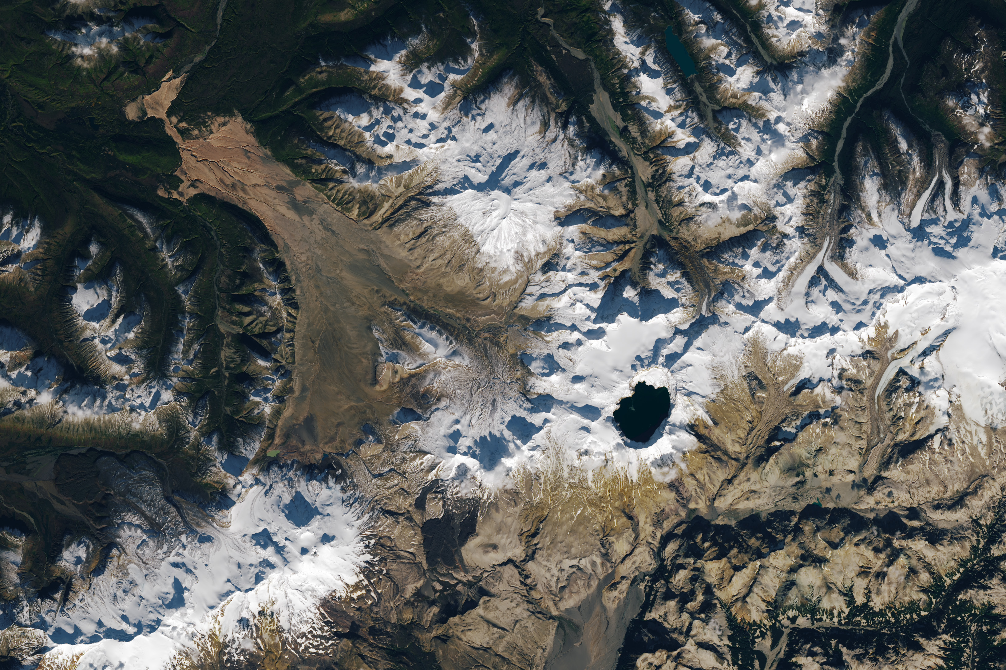
A satellite image shows part of Alaska’s Katmai National Park. A chain of snowy mountain peaks stretches from the bottom left corner to the right side of the image. The Valley of Ten Thousand Smokes is a long, tan-colored feature runs toward the northwest in the upper-left.
September 29, 2025

In preparing to visit the Moon’s surface, soon-to-be lunar explorers in NASA’s Apollo program first ventured into a variety of unfamiliar landscapes on Earth. A couple of these trips, in the summers of 1965 and 1966, took astronauts to Alaska’s remote Katmai National Park for simulations of field geology in Moon-like environments.

In one exercise, which they called “playing the Moon game,” pairs of astronauts were placed at unfamiliar field sites and asked to pretend as if they were on the Moon. By the account of William Phinney, Apollo’s science training coordinator, they were tasked with collecting representative geologic samples and practicing how to communicate their observations to scientists.

A detailed satellite image centers on the Valley of Ten Thousand Smokes in Alaska. The tan-colored feature runs southeast-to-northwest. Snowy peaks appear on the right side of the image, and green, forested valleys fill the left side.
September 29, 2025

The Alaskan setting for the Moon game was an unusual volcanic landscape called the Valley of Ten Thousand Smokes. The valley is full of debris deposited by the 1912 eruption of Novarupta—the largest volcanic event on Earth in the 20th century.

The images above, acquired on September 29, 2025, with the OLI (Operational Land Imager) on Landsat 9, show the massive ash flow deposited by Novarupta. The layer measures up to 660 feet (200 meters) thick and was emplaced at a searing 1,380 degrees Fahrenheit (750 degrees Celsius). 

The Valley of Ten Thousand Smokes, shown in the 1917 photo below, is so named because of the abundance of fumaroles—gas and steam-emitting vents—that filled the valley for a decade after the eruption. A few hundred persisted more than 10 years, with some lasting until the 1990s.

Three people stand in the foreground of this black-and-white photo, silhouetted by steam coming from a fumarole. A dark, barren landscape dotted with plumes of rising steam extends into the background.
1917

Scientists initially suspected that the monster eruption occurred at Mount Katmai, a neighboring volcano with a large caldera located 6 miles (10 kilometers) east of Novarupta’s dome. However, they later determined that the eruption actually occurred at Novarupta—whose name means “new eruption”—after stealing magma from beneath Katmai. As the magma chamber emptied, Katmai collapsed, forming the 2.5-mile-wide (4-kilometer-wide) caldera present today.

The volcanic landscape in the Valley of Ten Thousand Smokes is far fresher than the ancient lava flows that formed the Moon’s volcanic features. But for the Apollo astronauts, it offered an “excellent opportunity to view volcanic materials and landforms in nearly pristine condition,” Phinney wrote. They studied evidence of fumaroles and examined vertical sections of the deposits where streams had eroded deep gorges.

This photo shows a broad valley filled with tan-colored volcanic material in the foreground and snowy mountains in the background. The ashy volcanic deposits create a mostly flat valley floor, except where steep-sided chasms formed by erosion run through it.
June 9, 1991

Researchers continue to visit this Alaskan wilderness in search of clues that could help decipher the geology of the Moon and Mars. In 2024, the Goddard Instrument Field Team (GIFT) trekked to the Valley of Ten Thousand Smokes to study its icy volcanic landscape. Like the valley, Mars contains glaciers and ice sheets layered with dust and ash, a dynamic and difficult-to-interpret environment.

Advancing lunar science, the GIFT team also collected samples from rock formations comparable to the Moon’s Gruithuisen Domes. These mysterious features are made of hardened lava with a different composition than the surrounding rock. With more to learn about our nearest celestial neighbor, the spirit of the Moon game lives on in the 21st century.

NASA Earth Observatory images by Lauren Dauphin, using Landsat data from the U.S. Geological Survey. Photos from National Geographic Society Katmai expeditions photographs, Archives and Special Collections, Consortium Library, University of Alaska Anchorage, and from the U.S. Geological Survey Volcano Hazards Program. Story by Lindsey Doermann. 

Downloads

A satellite image shows part of Alaska’s Katmai National Park. A chain of snowy mountain peaks stretches from the bottom left corner to the right side of the image. The Valley of Ten Thousand Smokes is a long, tan-colored feature runs toward the northwest in the upper-left.

September 29, 2025

JPEG (2.64 MB)

References & Resources

You may also be interested in:

Stay up-to-date with the latest content from NASA as we explore the universe and discover more about our home planet.

Scoria Cones on Earth and Mars

7 min read

The hill-shaped features are a sign of explosive volcanic activity—a rarity on the Red Planet.

Article

A Volcanic Medley Near Mammoth Lakes 

4 min read

A massive, old caldera and more recently formed craters shape the landscape in the eastern Sierra Nevada.

Article

A Full Moon Checkup

3 min read

Once a month during the full Moon, Landsat 9 turns from Earth to image the lunar surface, helping keep the…

Article

Playing the Moon Game 

24 June 2026 at 05:01
A satellite image shows part of Alaska’s Katmai National Park. A chain of snowy mountain peaks stretches from the bottom left corner to the right side of the image. The Valley of Ten Thousand Smokes is a long, tan-colored feature runs toward the northwest in the upper-left.
September 29, 2025

In preparing to visit the Moon’s surface, soon-to-be lunar explorers in NASA’s Apollo program first ventured into a variety of unfamiliar landscapes on Earth. A couple of these trips, in the summers of 1965 and 1966, took astronauts to Alaska’s remote Katmai National Park for simulations of field geology in Moon-like environments.

In one exercise, which they called “playing the Moon game,” pairs of astronauts were placed at unfamiliar field sites and asked to pretend as if they were on the Moon. By the account of William Phinney, Apollo’s science training coordinator, they were tasked with collecting representative geologic samples and practicing how to communicate their observations to scientists.

A detailed satellite image centers on the Valley of Ten Thousand Smokes in Alaska. The tan-colored feature runs southeast-to-northwest. Snowy peaks appear on the right side of the image, and green, forested valleys fill the left side.
September 29, 2025

The Alaskan setting for the Moon game was an unusual volcanic landscape called the Valley of Ten Thousand Smokes. The valley is full of debris deposited by the 1912 eruption of Novarupta—the largest volcanic event on Earth in the 20th century.

The images above, acquired on September 29, 2025, with the OLI (Operational Land Imager) on Landsat 9, show the massive ash flow deposited by Novarupta. The layer measures up to 660 feet (200 meters) thick and was emplaced at a searing 1,380 degrees Fahrenheit (750 degrees Celsius). 

The Valley of Ten Thousand Smokes, shown in the 1917 photo below, is so named because of the abundance of fumaroles—gas and steam-emitting vents—that filled the valley for a decade after the eruption. A few hundred persisted more than 10 years, with some lasting until the 1990s.

Three people stand in the foreground of this black-and-white photo, silhouetted by steam coming from a fumarole. A dark, barren landscape dotted with plumes of rising steam extends into the background.
1917

Scientists initially suspected that the monster eruption occurred at Mount Katmai, a neighboring volcano with a large caldera located 6 miles (10 kilometers) east of Novarupta’s dome. However, they later determined that the eruption actually occurred at Novarupta—whose name means “new eruption”—after stealing magma from beneath Katmai. As the magma chamber emptied, Katmai collapsed, forming the 2.5-mile-wide (4-kilometer-wide) caldera present today.

The volcanic landscape in the Valley of Ten Thousand Smokes is far fresher than the ancient lava flows that formed the Moon’s volcanic features. But for the Apollo astronauts, it offered an “excellent opportunity to view volcanic materials and landforms in nearly pristine condition,” Phinney wrote. They studied evidence of fumaroles and examined vertical sections of the deposits where streams had eroded deep gorges.

This photo shows a broad valley filled with tan-colored volcanic material in the foreground and snowy mountains in the background. The ashy volcanic deposits create a mostly flat valley floor, except where steep-sided chasms formed by erosion run through it.
June 9, 1991

Researchers continue to visit this Alaskan wilderness in search of clues that could help decipher the geology of the Moon and Mars. In 2024, the Goddard Instrument Field Team (GIFT) trekked to the Valley of Ten Thousand Smokes to study its icy volcanic landscape. Like the valley, Mars contains glaciers and ice sheets layered with dust and ash, a dynamic and difficult-to-interpret environment.

Advancing lunar science, the GIFT team also collected samples from rock formations comparable to the Moon’s Gruithuisen Domes. These mysterious features are made of hardened lava with a different composition than the surrounding rock. With more to learn about our nearest celestial neighbor, the spirit of the Moon game lives on in the 21st century.

NASA Earth Observatory images by Lauren Dauphin, using Landsat data from the U.S. Geological Survey. Photos from National Geographic Society Katmai expeditions photographs, Archives and Special Collections, Consortium Library, University of Alaska Anchorage, and from the U.S. Geological Survey Volcano Hazards Program. Story by Lindsey Doermann. 

Downloads

A satellite image shows part of Alaska’s Katmai National Park. A chain of snowy mountain peaks stretches from the bottom left corner to the right side of the image. The Valley of Ten Thousand Smokes is a long, tan-colored feature runs toward the northwest in the upper-left.

September 29, 2025

JPEG (2.64 MB)

References & Resources

You may also be interested in:

Stay up-to-date with the latest content from NASA as we explore the universe and discover more about our home planet.

Scoria Cones on Earth and Mars
7 min read

The hill-shaped features are a sign of explosive volcanic activity—a rarity on the Red Planet.

Article
A Volcanic Medley Near Mammoth Lakes 
4 min read

A massive, old caldera and more recently formed craters shape the landscape in the eastern Sierra Nevada.

Article
Restless Kīlauea Launches Lava and Ash
3 min read

Episode 43 of the Hawaiian volcano’s current eruption was marked by high lava fountains and widespread ash dispersal.

Article

The post Playing the Moon Game  appeared first on NASA Science.

❌