 Login
A city with a plan
31 July 2026 at 12:09

Cincinnati wants to take in people fleeing climate disasters.

Cincinnati wants to take in people fleeing climate disasters.
Science word of the day: Seamount
Pronunciation: SEE'-mount
What it means: A seamount is an undersea mountain that rises at least 3,300 feet (1,000 meters) above the seafloor but does not come close to breaking the surface. According to the National Oceanic and Atmospheric Administration, there are at least 100,000 seamounts in the oceans, and less than 0.1% of them have been explored. Seamounts typically form from volcanic activity, and many host dramatic communities of sea life — from coral, to sharks, to an assortment of weird jellyfish-looking things.
How to use it in a sentence: Every time marine biologists explore a seamount with their remotely operated vehicles, they seem to discover a new universe of strange and blobby deep-sea creatures.
Can you crack our science word of the day puzzle, Chain Word?

Runoff from Greenland's rapidly melting ice sheet could severely disrupt currents in the Atlantic Ocean that regulate the global climate, researchers say. But the fresh water won't trigger the complete and irreversible collapse of the circulation that some research predicts, a new study suggests.
By 2100, Greenland meltwater could cause a reduction in the strength of the Atlantic Meridional Overturning Circulation (AMOC) equivalent to an additional 10% to 20% on top of the weakening that many scientists already expect for this huge system of currents, researchers found.
Previous research suggests the AMOC, which moves heat from the tropics to the Northern Hemisphere and cold water back south toward Antarctica, is at its weakest in more than 1,000 years due to Arctic ice melt and soaring ocean temperatures. Models indicate that the circulation will continue to weaken for decades to come, potentially unleashing freezing weather in Northwest Europe, additional sea-level rise along the U.S. East Coast and droughts around the equator.
The new study revealed that by 2300, Greenland's ice sheet could cause a whopping 40% of AMOC weakening on top of the declines projected by some climate models if we continue to cook the planet. The results highlight the effects on the AMOC of a growing freshwater pulse from Greenland that most climate models currently don't take into account, the authors said.
"By the year 2100, yes, we have something, but the greatest fraction is what we add later," study co-author Jost von Hardenberg, a professor in the Department of Environment, Land and Infrastructure Engineering at the Polytechnic University of Turin in Italy, told Live Science.
Meltwater from the Arctic and Greenland slows the AMOC by preventing the formation of deep currents in the North Atlantic that drive the circulation south toward Antarctica. Deep currents form when masses of cold, salty water sink to the seabed, but inputs of fresh water and rising water temperatures are blocking this step by diluting and warming surface waters.
While Arctic meltwater is commonly integrated into climate simulations, researchers have been slower to include runoff from the Greenland ice sheet in models, partly because this runoff may not be as disruptive as Arctic meltwater on shorter timescales, von Hardenberg said.
"In order to represent correctly the Greenland melt, you need a specific, dynamic model for the Greenland ice sheet. It's nice to have, but it requires a lot of resources to develop," von Hardenberg said
The Community Ice Sheet Model version 2 (CESM2) is one of the few available simulations of the Greenland ice sheet. For the study, von Hardenberg and his colleagues used a global climate model called EC-Earth3, which does not include the Greenland ice sheet. The team added the ice sheet from CESM2 to explore how it might affect the AMOC over the next few centuries. Adding the ice sheet separately enabled them to compare AMOC weakening with and without Greenland, clearly revealing the impact of the ice sheet on the AMOC's strength.
The results, published June 19 in the journal Science Advances, suggest the Greenland ice sheet will have a big influence on Atlantic ocean currents, especially after 2100.
"Greenland starts really melting strongly only after that date," von Hardenberg said. "If you go farther in our simulation — we go up to the year 2300 — that is also when this meltwater really becomes extremely strong."
Yet unlike other studies that show the AMOC collapsing irreversibly under climate change, in this model, the circulation recovered once the team switched off the meltwater or dialed down greenhouse gas emissions. Both the simulations that didn't include the Greenland ice sheet and those that did had similar results, recovering partially when the meltwater was turned off and fully when greenhouse gas emissions were stopped.
The recovery in the model suggests that the AMOC is more stable than previously thought and doesn't suddenly flip from an active state into a collapsed one, von Hardenberg said. "It's consistent with a strong weakening, but not a shutdown," he said.
Overall, the findings show that it is important to include the Greenland ice sheet in climate models — something von Hardenberg and his colleagues are planning to do in the next version of the EC-Earth3 model.
"It's really something which is worthwhile doing to better constrain the uncertainty of these future simulations," von Hardenberg said. "If we have a larger set of models which include this component, we will be in a better position to try to answer the question, 'How much do we expect AMOC to decrease in different scenarios?'"
Other experts agreed that integrating the Greenland ice sheet in climate models will increase the accuracy of AMOC predictions.
"What makes the study particularly interesting is that it directly tests a process that has often been highlighted as an important source of uncertainty in future AMOC projections," said Jonathan Baker, a senior climate scientist at the Met Office in the U.K. who was not involved in the study.
The results are consistent with previous research showing that Greenland meltwater causes additional AMOC weakening, but whether the system could collapse is still uncertain, given that the team used only one model, Baker told Live Science in an email. "Repeating these experiments across a wider range of models will be important to assess how robust the findings are," he said.
Nicholas Foukal, an assistant professor at the University of Georgia's Skidaway Institute of Oceanography who was not involved in the study, said he doesn't think the use of a single model limits the analysis.
"I think this result is robust and I am glad to see the authors come to this conclusion in such a high-resolution and realistic coupled climate model," Foukal told Live Science in an email. "This finding also agrees with other modeling results that require immense amounts of fresh water, much more fresh water than is available on Greenland, to cause irreversible change in the AMOC."
However, a third expert said the model used in the study is unrealistic, because its parameters make the AMOC more resilient than those of other models. Therefore, the study should be replicated in other models to draw unbiased conclusions.
"While the experiment reported is interesting, its outcomes are neither surprising nor should be interpreted as exemplary for the whole model ensemble," Sybren Drijfhout, a professor of physical oceanography at the University of Southampton in the U.K., told Live Science in an email.
Researchers should investigate the impact of the Greenland ice sheet on the AMOC further, von Hardenberg said. "It would be interesting in the future to check it [the AMOC's recovery with Greenland meltwater] with other models, but of course it's encouraging to see it in one case," he added.
Uncrewed systems are the future for armed forces and the Netherlands is leading the way ‘to keep people out of danger zones’
On each side of the target ship, a black vessel keeps a watchful distance. Defender 1 and Defender 2 are the eyes and ears of the navy – but they have nobody onboard, and their paths are controlled by a computer system.
This is the future of the Royal Netherlands Navy, according to Capt Sjoerd Feenstra, head of the expertise centre for unmanned systems. He is leading a five-week mission, off the coast of Den Helder in the north of the country, to test the limits of systems that operate without the human touch.
Continue reading...
© Photograph: John van Helvert/Media Centrum Defensie
© Photograph: John van Helvert/Media Centrum Defensie
© Photograph: John van Helvert/Media Centrum Defensie
Professional surfer and scientist Cliff Kapono gets his best ideas when he’s in the ocean. “The thinking turns off, but the ideas start to pour in,” he says. To him, the connection makes complete sense because the native Hawaiian word for “idea” is the same as “wave” — nalu.
Kapono is a native Hawaiian; these are the Indigenous people of Hawaii. He grew up in Hilo, Hawaii, where he is based today, blending his lifelong passions for surfing and science daily. “I want to understand how waves move across our planet, so I can be better at catching these waves,” he says.
As a kid, all he wanted to do was surf every day, all day long. He practiced until he could surf at a professional level. “That’s the same thing that I did in science. It started off where I just wanted to take science classes and get A’s. With surfing, the equivalent is catching nice waves,” Kapono says.
Kapono is now a professional free surfer. These athletes chase the best swells around the world to earn sponsorships and media exposure. He also has time to do scientific research. For Arizona State University’s Center for Global Discovery and Conservation Science in Hilo, he studies how humans and ocean environments interact, from molecular to macro scales, through the lens of a surfer. In this interview, he shares his experience and advice with Science News Explores. (This interview has been edited for content and readability.)
When I was younger, I didn’t think I could put the two together. But if I were to pursue a full-time career in either, I would be unhappy. So I figured out a path where I could spend just as much time inside the science lab as I am in the ocean. The Western world defines your job based upon what you get paid to do, not about what you invest your time into. I totally departed from that idea. My job is to be the best version of me. The best version of me is surfing good waves every day and understanding about the natural world through a scientific lens.
The clearest example of a productive society is the amount of leisure time they have. If you have a highly functioning system, you have surplus time. Our society was able to invest that time into the cultural arts, such as surfing.
Surfing has been documented within our histories for close to 2,000 years. It’s not just recreation. Surfing is so deeply embedded into the Hawaiian culture. It’s in the stories, the chants and the songs. It was celebrated tremendously by all peoples — from folks who were fisher people, farmers, basket weavers, cooks, to the royalty. In the late 1800s, it began being sort of exported outside of Hawaii and demonstrated at different locations around the world. By the 1950s, it reached global fame.
A success for me is elevating scientific literacy within the surf community. As a scientist, I represent an identity in the surf community that I didn’t see growing up. I can play that role for the next surfer scientist — or maybe it’s a surfer chef or surfer lawyer — to show that you can still contribute on a professional level to multiple communities within society at the same time.
I’m currently trying to identify the structural complexity of reefs at some of the best, most iconic waves around the world. It’s known as bathymetry, the study of the seafloor. I’m looking specifically at where certain famous waves break. Over the last five years, I’ve been traveling around mapping the characteristics of these different reefs. I’m seeing similarities between these waves based upon their reef structure. A personal interest and curiosity is now supported by research — that keeps me excited. Finding out that, by learning more about the reef, I can be a better surfer is a breakthrough for me.
I have gotten a lot of F’s in my academic career, but I’ve never felt like getting an F was a failure. My dad would always tell me that failure is an event, not a person. It’s just a moment that passes, so it’s not going to stay with you very long. So, I’ve actually embraced a lot of failures. I failed at many science experiments. I failed at catching a wave. I fail to ride the wave all the way to the shore. Sometimes I fail to even stand up. I fail in obtaining resources to do my science. I fail in knowing what the right answer is. I fail daily. But failing is not a bad thing if it helps you to find the successes. I don’t feel embarrassed or ashamed to fail anymore. I just tell myself that it’s all going to work out in the end if I don’t let the failure stop me.
Submit your question here, and we might answer it an upcoming issue of Science News Explores
I always looked up to elders in the Hawaiian community that maybe aren’t super famous but, within our communities, really treated me kindly and shared knowledge with me. Whether they were teachers, family members or professional surfers, I always looked up to people who were willing to share what knowledge they had with me. Anybody who helped me to navigate the difficulties of being on an island in a small community and feeling like there’s a bigger world out there. Anybody who helped me to get to a higher level of thinking and develop my intelligence, from my academic intelligence to my emotional intelligence. The people who helped me understand more about the world and myself.
I volunteer for a scientific group called Mega Lab that is trying to develop technology to protect the ocean and give it to communities who need it the most. The biggest project we have going on right now is mapping a million reefs by 2030. We’re teaching 10,000 citizen scientists how to map the reef with their GoPro, cell phone or camera. The program is called Map to Adapt. Anyone can join the Mega Lab — artists, skaters, ballerinas or firefighters. There are no requirements, you just come by and start doing science together. We just want to have a good time and party for the planet.
Having an interest in science really has helped me to be a better surfer. And my interest in surfing has helped me to become a better scientist. Science is like a superpower for me. It’s really fun to be able to jump from a community that is so focused on riding a wave into one that wonders about how that wave moves. To me, that’s a pretty epic way to live.
Where is it? Great Bahama Bank, Bahamas [23.547188707, -76.46352937]
What's in the photo? Submerged sandbanks and seagrass beds in shallow water
Which satellite took the photo? Landsat 8
When was it taken? Feb. 15, 2020
This ethereal satellite snap shows beautiful, "painting-like" folds within an ancient underwater structure in the Bahamas.
The Great Bahama Bank (GBB) is a massive submerged platform stretching around 330 miles (530 kilometers) across a shallow ocean channel between Andros Island and the Exuma islands, according to Britannica. The crescent-shaped bank surrounds a darkly colored ocean drop-off known as "The Tongue of the Ocean," which plunges to depths of 6,500 feet (2,000 meters), according to NASA's Earth Observatory.
The photographed section of the GBB is around 23 miles (37 km) across and features a series of submerged sandbanks — most of which are covered with dense seagrass beds — that lie between 7 and 40 feet (2 to 12 m) below the ocean's surface.
The varying water depth and seagrass concentration cause multiple hues of green and blue to shine across the sandbanks, which have been carved into smooth, folding ribbons by ocean currents over thousands of years.
"The varying colors and curves remind us of graceful strokes on a painting," Earth Observatory representatives wrote.
This section of the GBB was first photographed in 2001 by the Landsat 7 satellite and has often appeared on lists of the most iconic aerial images of our planet.
"There are many nice seagrass and sand patterns worldwide, but none like this anywhere on Earth," Serge Andréfouet, an oceanographer at the French National Research Institute for Sustainable Development who first shared the 2001 image, told the Earth Observatory. "I am not surprised it is still a favorite, especially for people who see it for the first time."
The sandbanks are like giant underwater dunes carved out by ocean currents.
"Tides and ocean currents in the Bahamas sculpted the sand and seaweed beds into these multicolored, fluted patterns in much the same way that winds sculpted the vast sand dunes in the Sahara Desert," Earth Observatory representatives wrote in 2001.
The GBB lies atop a roughly 3-mile-thick (5 km) bed of limestone dating to the age of the dinosaurs, more than 65 million years ago. This hefty mass, made up of the remains of long-dead coral reefs, is so large that Earth's crust directly below the GBB has "sagged under the weight," according to the University of Texas at Austin's Marine Science Institute.
Before the end of the last ice age, around 12,000 years ago, this limestone slab had risen to more than 400 feet (120 m) above sea level and only resubmerged as global sea levels rose due to the melting of glaciers, according to the Marine Science Institute.
The Bahamas has more than 3,000 islands and smaller cays and is home to several other intriguing oceanographic features, including deep tidal channels off the coast of Great Exuma Island (which once harbored famous pirate ships) and a series of aurora-like sandbanks that appear to shine along the nation's northernmost islands.
Glowing ring of algae in New Zealand
A 2026 satellite photo captured a gleaming halo of phytoplankton encircling the remote Chatham Islands. The stunning sight is the result of a hidden underwater structure, which has also helped kill hundreds of cetaceans.
'Arctic blast' paints plume in Florida
A 2026 satellite photo captured a stunning scene of sediment swirling across the West Florida Shelf after an extreme cold snap that covered large parts of the eastern U.S. in snow.
Whale-shaped island in Belize
A 2020 astronaut photo shows the unusual cetacean-like shape of Belize's Lighthouse Reef. It's home to the famous Great Blue Hole, which doubles as the island's "blowhole" when viewed from space.
A giant blob of abnormally cold water in the North Atlantic Ocean is shifting the Indian summer monsoon, threatening the livelihoods of more than 1 billion people, new research suggests.
The link between these two systems highlights a previously unrecognized connection that could inform weather forecasts in South Asia and shed light on climatic events elsewhere, scientists say.
The Indian summer monsoon is a rainfall pattern that lasts from June to September and is driven by temperature differences between the warm northern Indian Ocean and cooler seawater below the equator. Historically, the monsoon triggered heavy rainfall along the west coast of India and a huge region of northern India called the Indo-Gangetic Plain. But since 1999, this pattern has changed dramatically, the researchers reported in a new study.
Northwest India now receives about 25% more rain during the monsoon season than it did before 1999, while the Indo-Gangetic Plain gets roughly 4% less, the team found. This is disastrous for farmers, in particular, because their soils and crops are adapted to the old rainfall pattern, said study first author Mahendra Nimmakanti, a climate scientist at the Indian Institute of Science's Centre for Atmospheric and Oceanic Sciences.
"India is largely dependent on agriculture," Nimmakanti told Live Science in a joint interview with study co-author Matthew Huber, a professor in the Department of Earth, Atmospheric, and Planetary Sciences at Purdue University in Indiana. Higher-than-normal precipitation in northwest India is causing flash floods and crop losses, because agriculture in this region is adapted to dry conditions. Meanwhile, the Indo-Gangetic Plain has seen periods of drought that also caused crop declines and impacted farmers' livelihoods, Nimmakanti said.
Previous studies have linked shifts in the Indian summer monsoon to changes in the Atlantic Meridional Overturning Circulation (AMOC), a giant web of ocean currents in the Atlantic that regulates the global climate and carries heat to the Northern Hemisphere. Data suggests the AMOC is slowing due to climate change and releasing less heat in the North Atlantic Ocean than it did before. This may be causing a southward shift of the Intertropical Convergence Zone, a band of low-pressure atmospheric conditions around the equator that drives tropical monsoons, including the Indian summer monsoon.
But these studies didn't specify how the Indian monsoon might shift or explain the underlying mechanism in detail, Nimmakanti said. "They generally explain that if there is a weakening of AMOC, that suppresses the Indian summer monsoon," he said.
One part of the problem is that current climate models do not show the changes in the Indian monsoon that have happened in real life, possibly because they also don't fully capture shifts in North Atlantic sea surface temperatures. This is especially true for a region southeast of Greenland known as the "cold blob," where the water was colder between 1901 and 2021 than it was in the late 1800s, even as the ocean around it heated up.
The cold blob suggests the AMOC is weakening because it points to a reduction in the amount of heat reaching the North Atlantic.
To pinpoint how and why the Indian monsoon has changed, the researchers fed precipitation data, sea surface temperature records and other real-life observations into dozens of climate models. This reproduced the shifts observed over the past 27 years. However, the results only implied a correlation between shifts in the North Atlantic and changes in the monsoon, not that the former directly caused the latter.
To figure out if North Atlantic sea surface temperatures caused the Indian monsoon to behave strangely, the team added and removed the cold blob in a simulation. The results showed that the cold blob has shifted the Indian monsoon by creating a strong temperature gradient over the North Atlantic, which, in turn, affects jet stream winds and pressure systems in the atmosphere above Eurasia.
Specifically, the jet stream above the North Atlantic has intensified, and a "blocking" system over the Ural Mountains in western Russia has strengthened, Huber said. As a result, weather systems in India have changed, sucking moist air toward the country's northwest and away from other regions.
"It's a shifting of the high- and low-pressure systems," Huber said. "Realizing that these two systems were directly linked through this wave train coming off the North Atlantic, that was novel."
More than 1 billion people in India and other parts of South Asia depend on the monsoon for food security and economic stability. The new results, published April 27 in the journal AGU Advances, could help forecasters predict extreme rainfall and drought events in India and neighboring countries like Pakistan during the monsoon season.
Some researchers think the Indian monsoon is a key tipping point within the global climate, and the findings suggest the system crossed a threshold in 1999. Since then, the cold blob has caused a "persistent jet stream reorganization," leading to abrupt shifts in the monsoon, according to the study.
It's unclear how the Indian monsoon will evolve under intensifying climate change, because climate models produce different predictions of what will happen in the North Atlantic, and other drivers may come into play as the world changes, Huber said.
"What we do now know is that this is one of the key building blocks of formulating a theory for what will happen in the future," he said.
In the profound depths of rocky planets like Earth and Mars, the precise chemical states of mantle minerals play a foundational role in shaping planetary evolution. Among these chemical states, the oxidation state of iron profoundly influences mantle melting behaviors, volcanic gas compositions, and ultimately, the nature of a planet’s surface environment. While the elemental presence of iron in the mantle is well-known, the subtle balance between its ferrous (Fe²⁺) and ferric (Fe³⁺) forms remains a challenging frontier to unravel, particularly under the extreme pressures and temperatures encountered in planetary interiors.
The early stages of planetary formation are marked by the existence of a vast magma ocean—a molten silicate layer blanketing the young Earth and Mars. During this epoch, the oxidation state at which iron integrates into forming minerals dictates subsequent mantle properties and evolution. Accurately determining the Fe³⁺ content in minerals crystallized within this magma ocean stands as a critical step toward understanding the oxidation dynamics that influenced core-mantle differentiation and surface volatile release in nascent planets.
A mineral of prime relevance in this context is majorite, a high-pressure silicate phase stable at depths ranging roughly from 500 to 600 kilometers within Earth’s mantle and near the base of the Martian mantle. Its stability under simultaneously high-pressure and high-temperature conditions makes majorite a significant reservoir for iron deep within these planetary interiors. Therefore, quantifying the Fe³⁺ concentration hosted within majorite under early magma ocean conditions bears directly on models of mantle redox evolution and volatile mobility.
Researchers at Ehime University’s Geodynamics Research Center have pioneered the synthesis of Fe³⁺-rich majorite coexisting with molten silicate magma at pressures around 18 gigapascals and temperatures between 2150 and 2200 degrees Celsius. Utilizing a multi-anvil apparatus capable of reproducing these extreme conditions, the team closely simulated the environment of the early magma ocean. High-precision X-ray Absorption Near Edge Structure (XANES) spectroscopy was then employed at the renowned SPring-8 synchrotron facility to accurately assess the valence state of iron within the synthesized majorite crystals.
The findings reveal an unexpectedly high Fe³⁺ content in majorite crystallized from the magma ocean, second only to bridgmanite, Earth’s most abundant lower mantle mineral. This marked enrichment in ferric iron suggests that early mantle minerals could accommodate significant oxidation capacity, challenging earlier assumptions that high-pressure silicates predominantly contain iron in the ferrous state. The implication is that the early mantle harbored more oxidized iron species than previously anticipated, impacting mantle viscosity, melting relations, and the capacity to store volatile elements.
Importantly, as mantle solids ascend toward shallower depths, phase transitions or mineral decompositions can liberate excess Fe³⁺ that no longer fits within the crystal structures. This released ferric iron potentially contributes to the generation of oxidized magmas, influencing volcanic gas emissions and surface oxidation states. Such a mechanism presents a plausible link between deep mantle oxidation states and the chemical makeup of magmas erupted at the surface, offering fresh insights into the geological histories of both Earth and Mars.
The study’s revelations offer a new lens through which to interpret the evolution of mantle oxidation state gradients over geological time. Understanding how iron’s valence shifts across depth-dependent mineralogical boundaries and during mantle convection cycles will refine planetary differentiation models and volatile cycling frameworks. The presence of Fe³⁺-rich majorite highlights a previously underappreciated redox reservoir deep within planetary interiors.
These results not only enhance our appreciation of Earth’s early differentiated mantle but also extend to Mars, where recent seismic and geochemical data point to a similarly complex mantle composition. The redox state plays an outsize role in Martian volcanic outgassing and atmospheric evolution, making this research vital for reconstructing Mars’ geochemical past and assessing its potential habitability.
From a methodological standpoint, the study exemplifies the power of integrating high-pressure experimental petrology with cutting-edge synchrotron techniques. The ability to recreate extreme planetary interior conditions and directly probe valence states in situ offers a transformative approach to addressing longstanding questions about deep Earth and planetary chemistry.
Furthermore, the recognition that Fe³⁺ can be abundant in magma ocean-derived minerals necessitates revisiting thermodynamic and geochemical models of mantle melting and evolution. Oxidation state strongly influences melting temperatures and mantle rheology, thereby controlling convection patterns and surface tectonics. Such feedbacks are essential to comprehend in the broader context of planetary habitability and evolution.
Ultimately, these insights pave the way for multidisciplinary endeavors bridging mineral physics, planetary science, and geochemistry. They underscore the dynamic interplay between deep Earth processes and surface conditions, revealing how the smallest changes in iron’s electron configuration resonate across planetary systems.
This breakthrough in understanding iron’s complex behavior under extreme conditions promises to guide future explorations of terrestrial and extraterrestrial geology. It sets new constraints on the interior states of rocky planets and sharpens our vision of how early planetary environments were sculpted by subtle shifts deep within.
Subject of Research: High-pressure mineralogy and mantle oxidation states in terrestrial and Martian planets.
Article Title: (Not explicitly provided in the original content.)
News Publication Date: (Not indicated in the original content.)
Web References: http://dx.doi.org/10.1029/2025JB033231
References: Journal of Geophysical Research Solid Earth
Image Credits: Hideharu Kuwahara
Keywords:
– Fe³⁺ in mantle minerals
– Majorite synthesis under high pressure
– Magma ocean oxidation states
– Mantle redox evolution
– XANES spectroscopy at SPring-8
– High-pressure experimental petrology
– Earth and Mars mantle comparison
– Ferric iron incorporation in majorite
– Oxidized magma generation
– Planetary interior chemistry
– Lower mantle mineralogy
– Planetary differentiation processes

You might think birds skimming over the ocean wouldn’t seek wind unless it was pushing them in the right direction, but NASA-funded researchers have learned that storm petrels find stiff crosswinds worth the slowdown, in return for the clues and cues the gusts carry.
In a paper published by the Royal Society’s Biology Letters May 13, researchers from Woods Hole Oceanographic Institution (WHOI) and the Italian Institute for Environmental Protection and Research (ISPRA) found that Mediterranean storm petrels actively sought out crosswinds, which carried odors the birds used to navigate toward prey. The birds were effectively trading the extra energy needed to fly in a crosswind for the information it blows toward them.
These sparrow-sized birds routinely undertake foraging trips hundreds of miles over the sea, returning to the breeding colony to relieve their partners from incubation duties. Until recently, their small size has precluded researchers’ ability to tag them, keeping their journeys a mystery. In 2020 and 2021, working on the Italian island Sardinia, the team, led by ISPRA and WHOI, attached lightweight GPS sensors to the birds, adding just 3.3% of the birds’ weight as they set out over the Mediterranean Sea.
This finding could help reveal how changing winds might impact seabirds’ feeding, breeding, energy levels, and survival, adding insights about patterns of nutrients in the sea — and the forces that create them.
~Karen Romano Young
The post NASA-Funded Research Follows Bird Flight; Birds Follow Their Noses appeared first on NASA Science.
Editor’s note: This article was updated on June 5.
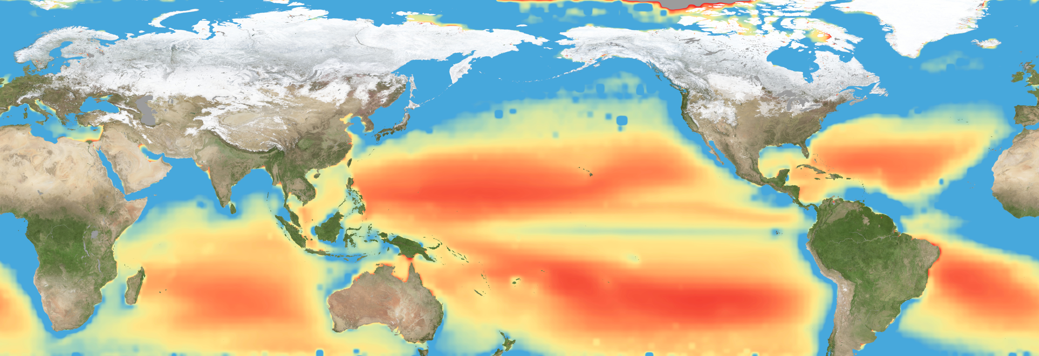
A new study combining NASA satellite observations, ocean surveys, and genetic testing on marine microorganisms found evidence that warming ocean waters may be limiting nutrient availability across much of the global ocean. The researchers report that this nutrient stress affects microscopic marine organisms and could influence marine ecosystems over time.
The research, published June 5 in Science Advances, tracked the condition of phytoplankton, which form the base of ocean food webs. Rather than measuring nutrients like nitrogen, iron, and phosphorus directly, the researchers inferred stress by tracking subtle shifts in the ratio of carbon to chlorophyll in phytoplankton observed from space. When the amount of chlorophyll decreases relative to carbon as seen in satellite data, it’s an indication that the plankton are stressed.
“As our ocean continues to change, the ability to observe and track ocean conditions through sustained, high quality remote sensing observations has never been more important,” said Laura Lorenzoni, Program Scientist for NASA’s Ocean Biology and Biogeochemistry Program at NASA Headquarters in Washington. “This is fundamental, as plankton communities are the base of the marine food web on which important economic activities rely.”
The research team combined two decades of data from NASA’s Aqua satellite’s Moderate Resolution Imaging Spectroradiometer (MODIS) sensor with plankton samples collected on research cruises around the world. The approach linked large-scale satellite observations with genetic markers in Prochlorococcus, a tiny but abundant marine microbe that shows signs of nutrient stress in its DNA. The result is a global map revealing where phytoplankton are thriving and where they’re struggling.
The strongest indications of nutrient stress on plankton appeared in the subtropical gyres, which are vast, relatively calm regions of the Atlantic, Pacific, and Indian oceans. In these areas, a layer of warm surface water stifles the flow of colder water from deeper in the ocean.
“When the surface of the ocean warms, it generates this very stable situation where a layer of low-density water sits on top of higher-density cold water,” said study coauthor Adam Martiny, an oceanographer at the University of California, Irvine. “You’ve probably experienced that if you’ve ever been to a lake in the summertime—it’s super warm right on the surface, and very cold deeper down when you stick your legs in.”
This layering blocks the upward flow of nutrient-rich water, limiting the availability of ocean surface nutrients that are crucial for plankton. In the South Pacific, one of the most nutrient-poor regions, a layer of warm surface water contributed to nitrogen and iron shortages, producing the most severe nutrient-related stress that the team discovered.
But the researchers were surprised to find that parts of the North Atlantic experience less nutrient stress than expected. Although there was evidence of a lack of phosphorus, the impact on microorganisms was comparatively mild.
That difference may reflect the biology of the organisms themselves. Phytoplankton can partially compensate for phosphorus shortages by recycling phosphorus more efficiently or replacing phosphorus-rich molecules inside their cells. Nitrogen shortages are harder to overcome because nitrogen is crucial for the proteins and cellular machinery required for photosynthesis and nutrient uptake.
The study revealed that nutrient stress is strongly correlated with seasons and major weather cycles such as El Niño and the Pacific Decadal Oscillation, which lead to warming waters in the Pacific Ocean. During La Niña events, which cool water over a large part of the Pacific, stronger upwelling brought more nutrients to surface waters and reduced stress in some regions. Superimposed on those multi-year cycles, however, was a longer-term trend.
From 2002 through 2021, average sea-surface temperatures increased across nearly 90% of the ocean area examined in the study. Over the same period, nutrient stress generally intensified, consistent with previous hypothesis that warming oceans may become increasingly stratified and less able to replenish surface nutrients.
In many nutrient-poor regions of the Southern Hemisphere, however, the researchers found evidence that nutrient stress had not increased as much as expected despite significant warming. They suspect that microbes capable of capturing nitrogen from the air may partially offset the effects of reduced nutrient mixing.
That finding hints that marine ecosystems may possess more resilience to warming climates than some models predict. It also underscores the complexity of forecasting how ocean biology will respond to continued warming.
“We have two really powerful tools,” said study coauthor Michael Behrenfeld, a biochemist with Oregon State University in Corvallis, Oregon. The tools include satellite observations and cellular studies. “Both produce big data sets, but they are kind of opposites. We have very detailed data about microscopic phytoplankton … and then we have global coverage with satellites.”
By combining satellites that monitor the entire ocean with genetic clues carried inside microscopic plankton, the researchers say they are gaining a new way to track biological responses to changing environmental conditions near real time.
By James Riordon
NASA’s Earth Science News Team
Media contact: Elizabeth Vlock
NASA Headquarters
The post NASA Satellites Help Map Ocean Nutrient Stress appeared first on NASA Science.
Take a plunge into Australia’s Great Barrier Reef, and you’ll come face to face with a what looks like a gorgeous rocky garden. This dazzling array of corals is the largest living structure on Earth. Some, like staghorn coral, look like leafless bushes sprouting from the ocean floor. Others, such as honeycomb coral, resemble rocks dotted with tiny holes. Then there’s brain coral, which, you guessed it, look like brains. And that’s just a small sample of the brilliant diversity to be found in a reef.
Despite their appearance, corals are animals. These invertebrates are close relatives of jellyfish and sea anemones. Most corals live in colonies of thousands of tiny individuals called polyps growing together. Each polyp sports a cylindrical body topped with a ring of tentacles surrounding its mouth.
“You can think of them as upside-down jellyfish,” says Peter Cowman. At Queensland Museum Tropics in Townsville, Australia, this marine biologist studies the evolutionary history of corals.
Like their jellyfish cousins, coral polyps use tentacles to feed and defend themselves. These appendages are packed with specialized stinging cells called nematocysts. Each contains a coiled, barbed thread. When touched, the cell “fires” this thread to inject venom into its target. Most corals hunt at night, snagging tiny zooplankton, floating eggs and small fish.
Many corals have a more laid-back way of feeding, too. Inside their tissues, they house algae called zooxanthellae (Zoh-uh-ZAN-thuh-lay). (This is an example of symbiosis, where two creatures benefit by associating together.) These single-celled organisms are photosynthetic. They use light and carbon dioxide to make sugars and proteins. Most of these nutrients are offered to the coral. “In return, the coral gives them a safe apartment to live in,” says Cowman. “They’re the solar-powered roommates.”
Corals that rely on light-powered algae live in shallow, warm waters. It’s here where you find coral reefs. These structures are made by a type of coral called hard or stony corals. “They are the engineers of the reef system,” says Cowman.
Stony corals produce hard skeletons of aragonite, a mineral made of calcium carbonate. Over hundreds to thousands of years, generations of polyps can build up massive reef systems.
Soft corals, like their name implies, don’t make these stony skeletons. Instead, they have bendy structures that move with ocean currents. They can often be found living among reefs, though. “The soft corals are like the decorators,” says Cowman. “They look like underwater swaying trees and fans.”
Some corals — both soft and hard — can live in deep water, up to 6,000 meters (20,000 feet) below the water surface. Stony corals found at these depths are often smaller than their shallow-water counterparts. Most tend to live as single polyps. Some species do create reefs, but they’re less of a team effort. Called “mounds,” these deep reefs grow over the skeletons of old or dead corals on the ocean floor.
The first true corals appeared about 500 million years ago. But many of today’s reef-building corals can be traced back to the end of the Cretaceous Period some 66 million years ago. That’s when an asteroid impact wiped out about 80 percent of all animals (including the nonbird dinosaurs).
“The mass extinction had an effect in the oceans as well,” says Cowman. Existing reef-builders died out. Their extinction allowed stony corals to take their place. Today, corals are found in all of the world’s oceans.
But many are at risk from human activities. These dangers include pollution and destructive or heavy fishing. One of the biggest threats is climate change. High water temperatures and too much sunlight can stress corals, leading to a phenomenon called coral bleaching.
At higher temperatures, the algae produce toxic compounds. “When the water gets too hot, the coral gets stressed and they evict their zooxanthellae,” says Cowman. These microbes are also responsible for a coral’s bright colors. In their absence, the coral’s tissues turn transparent. All that remains visible is the coral’s white skeleton.
Bleaching doesn’t kill the coral immediately. If conditions improve, the coral may recover and even take the algae back in. But if coral go too long without their algal partners, they may get sick or die. “If they can’t get the zooxanthellae back in again, they [will] actually starve to death,” says Cowman.
This bleaching affects coral worldwide. Since 2023, the world’s corals have been experiencing the largest bleaching event on record.
Many scientists and conservationists are concerned about corals’ future. Coral reefs are among Earth’s most diverse ecosystems. Though they cover less than one percent of the seafloor, coral reefs support at least one-fourth of all marine species. “On land, you think of rainforests as having all that diversity,” says Cowman. “The rainforests of the sea are the coral reefs.”
Corals are important for people, too. Humans rely on many reef-dwelling species for food. Reefs can also buffer coasts against damage from strong waves or storms, says Cowman. Chemical compounds from reef animals have been found to help fight pain and treat cancer. And reefs support tourism around the globe. The food, products, jobs and coastal protection provided by corals are estimated to be worth $2.7 trillion per year.
Says Cowman, “as humans, we rely on reefs a lot in our daily lives, even if we don’t think of it.”
