Mesmo num eclipse total, a tecnologia ajuda a que ninguém fique de fora. Chama-se LightSound e é um pequeno dispositivo capaz de transformar a luz do Sol em notas musicais, permitindo que pessoas cegas ou com deficiência visual "ouçam" a passagem da Lua em frente ao astro-rei.
As larvas da mosca-varejeira, uma mosca, alimentam-se de tecidos vivos. São o exemplo perfeito de parasitas devoradores de carne saídos diretamente de um filme de terror. A mosca-varejeira, ou Cochliomyia hominivorax, põe seus ovos em feridas ou mucosas de animais…
À medida que os incêndios florestais continuam a afetar várias regiões da Europa, um nova ferramenta, que usa dados dos satélites Copernicus, permite acompanhar, em tempo real, a evolução dos fogos, a propagação do fumo e as emissões de carbono.
O câncer de pulmão agrupa várias doenças. Alguns tumores apresentam uma modificação particular, chamada ROS1, que favorece seu desenvolvimento. A FDA americana acaba de aprovar um novo medicamento, Jideytro, para adultos cujo câncer se espalhou ou não pode mais ser…
Uma campanha científica deve observar de perto as imensas nuvens de tempestade geradas por alguns incêndios. Batizada INSPYRE, ela mobiliza vários aviões, instrumentos em solo e satélites. Seu objetivo é entender como esses fenômenos impulsionam fumaça e partículas para as…
Robôs humanoides realizaram gestos de cirurgia laparoscópica (através de pequenas incisões) em porcos anestesiados. A experiência, conduzida por pesquisadores da Universidade da Califórnia em San Diego, constitui um teste pré-clínico do uso de robôs polivalentes em um bloco operatório. As…
Uma forma rara de câncer transmissível acaba de ser identificada em peixes-gato marrons que vivem em um lago compartilhado pelos Estados Unidos e Canadá. As células tumorais parecem passar de um animal para outro, um fenômeno excepcional em animais e…
Um material magnético desenvolvido na Austrália eliminou mais de 95% dos microplásticos e nanoplásticos presentes em amostras de água. Os testes também mostraram ação sobre produtos químicos e alguns PFAS, uma família de produtos persistentes frequentemente chamada de "poluentes eternos".…
A diminuição invernal da banquisa ártica retoma, e isso tem consequências. Um estudo publicado em 20 de julho na PNAS mostra que a desaceleração aparente observada no início dos anos 2020 correspondia, afinal, a uma pausa temporária. Os níveis registrados…
O asteroide responsável pela extinção dos dinossauros provavelmente não era um vulgar rochedo espacial. Uma nova análise indica que pertencia a uma família extremamente rara de meteoritos, os condritos carbonáceos do tipo CO. Este esclarecimento conta-nos a origem do projétil…
A Grande Barreira de Coral possui um ecossistema microbiano muito mais vasto do que as observações clássicas faziam supor. A análise do ADN presente na água revelou centenas de espécies bacterianas desconhecidas, bem como centenas de milhares de vírus. Os…
Existe um segredo oculto por trás dos desertos do nosso planeta. Do Saara às terras geladas do Ártico, essas extensões áridas têm uma coisa em comum: falta de chuva. Mas por que alguns lugares da Terra recebem muito menos precipitação…
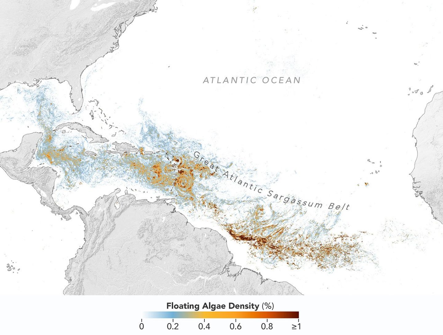
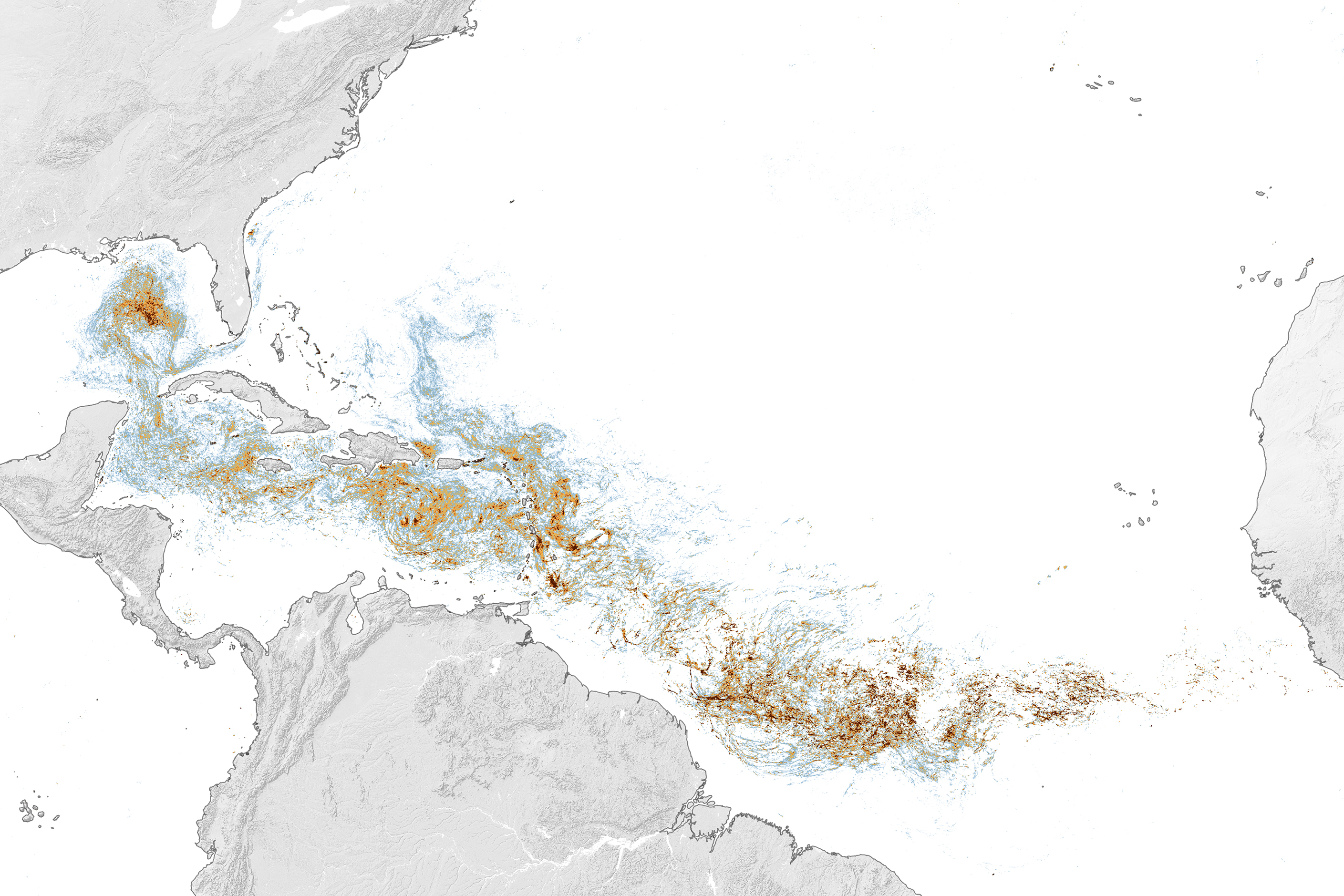
This map, based on data from the OCI (Ocean Color Instrument) on NASA’s PACE (Plankton, Aerosol, Cloud, ocean Ecosystem) satellite, shows Sargassum highly concentrated in the tropical Atlantic in June 2026.
NASA Earth Observatory/Lauren Dauphin
Sargassum, a type of brown floating algae, has shifted its range in recent decades, thinning out in the North Atlantic’s Sargasso Sea while proliferating in the tropical Atlantic. That trend, underway since 2011, continued in 2026 as the algae, commonly known as a type of seaweed, reached its annual peak in June across a stretch of ocean known as the Great Atlantic Sargassum Belt.
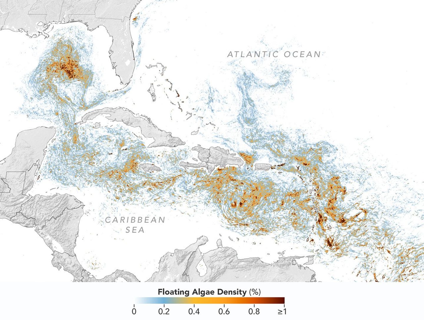
The belt’s Sargassum abundance in June 2026 made it the second-highest Sargassum year in the satellite record, slightly behind 2025, according to scientists at the University of South Florida (USF) College of Marine Science. Regionally, the Caribbean Sea and the Gulf of America (Gulf of Mexico) both hit record highs, according to USF’s June 2026Sargassum outlook. The western and eastern Caribbean saw 3.6 and 9 million metric tons, respectively, while the Gulf saw 5 million metric tons—nearly double its previous record, also set in 2025.
“The belt is a basin-scale phenomenon that can have devastating local-scale impacts throughout the Caribbean and Gulf, and satellite observations are the only method that captures both scales on a daily basis,” said Brian Barnes, a marine scientist at the Optical Oceanography Laboratory at USF. “The tracking done by our lab helps communities know the current extent of Sargassum and prepare for what’s to come.”
In moderate amounts in the open ocean, Sargassum provides habitat for turtles, invertebrates, fish, and birds, and adds oxygen to the water through photosynthesis. But too much of it near shore can tangle and suffocate marine life, and mats that sink can smother corals and seagrasses. On beaches, decomposing Sargassum releases hydrogen sulfide, a rotten-egg-smelling gas that’s a potential problem for both ecosystems and tourism.
The map above shows Sargassum density in the tropical Atlantic Ocean in June 2026. Red and orange areas are where Sargassum densities were the highest. Note that although the “belt” appears continuous, discrete Sargassum mats are scattered across the ocean surface. The map is based on satellite measurements of how much of the ocean surface was covered by the seaweed, averaged per pixel across all observations made in June by the OCI (Ocean Color Instrument) on NASA’s PACE (Plankton, Aerosol, Cloud, ocean Ecosystem) satellite.
This detailed view of the same PACEOCI map highlights Sargassum concentrations across the Caribbean Sea and Gulf of America, both of which saw record-high amounts of the floating algae in June 2026.
NASA Earth Observatory/Lauren Dauphin
Ocean currents and winds shape the Sargassum belt, which, despite the patchiness, stretches nearly continuously from West Africa to the Gulf and holds a fairly steady “width” from the western tropical Atlantic westward, explained Chuanmin Hu, also an optical oceanographer at USF. The ocean currents have also spared Florida’s west coast from inundation this summer, while delivering large amounts of seaweed to the Florida Keys and the state’s east coast. The bulk of the Sargassum, however, is visible in the Caribbean Sea, shown in detail above, where problems associated with inundation have been more severe, Hu said.
Data for the maps were provided by Lin Qi, an oceanographer at NOAA’s Center for Satellite Applications and Research, who has been working to generate Sargassum maps based on data from PACE, which was launched in February 2024. The work extends that of Qi and colleagues at USF’s Optical Oceanography Laboratory. This team first developed Sargassum detection techniques using MODIS (Moderate Resolution Imaging Spectroradiometer) on NASA’s long-running Terra and Aqua satellites and VIIRS (Visible Infrared Imaging Radiometer Suite) on the NOAA-20 satellite—data that have been a key component of USF’s Sargassum Watch System and of research into the seaweed’s longer-term trends.
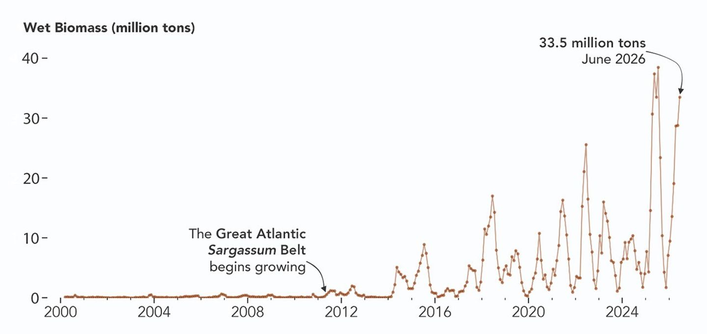
Satellites detect Sargassum by its signals in reflected sunlight. Because of its plant structure and chlorophyll pigments, Sargassum reflects more near-infrared light than water. Scientists flag pixels where the reflectance spikes above the levels produced by plain seawater, and then they use the strength of this spike to estimate Sargassum density, which refers to the fraction of ocean surface covered by the seaweed in each pixel. Density estimates can then be converted into biomass, or the total weight of Sargassum present within a pixel, which is how the longer-term trends in the chart below are tracked.
NASA Earth Observatory/Lauren Dauphin
The chart above uses the continuous MODIS record since March 2000 to show how Sargassum biomass across the Great Atlantic Sargassum Belt has changed through June 2026. Notice the uptick beginning around 2011, when the belt was first developing, and the seasonal dips in winter and peaks in spring and summer. The record high in July 2025 stands out, followed by the quick rise in early 2026—especially in the first four months of the year—that culminated in the year’s peak in June. More recent observations, not yet reflected in the chart, indicate Sargassum biomass declined through the following month of July.
“Since the initial appearance of the Great Atlantic Sargassum Belt in 2011, the total Sargassum amount in the Atlantic Ocean has increased substantially, more than doubling every five years,” Hu said. He added that the exact mechanism is still being investigated, but it’s possibly related to ocean warming, multiple nutrient sources, and the fact that large Sargassum mats attract other organisms—such as nitrogen-fixing bacteria—that can supply additional nutrients to sustain further growth.
Alongside data from MODIS and VIIRS, OCI data from PACE now feeds into the Sargassum Watch System’s near-real-time daily and weekly composite maps. A recent study of the central-west Atlantic led by Qi, spanning May through August 2024, found that OCI offers several advantages over its predecessors, observing more of the ocean and detecting Sargassum with greater sensitivity.
Hu noted that the added pixels from OCI can improve near-real-time monitoring and analyses of short-term fluctuations. And its higher sensitivity, he said, will also lead to improved maps during winter months, “thus helping understand Sargassum changes over time.”
Additionally, the study’s authors found that OCI’s hyperspectral capability makes it the only sensor able to spectrally discriminate Sargassum pixels across the Atlantic Ocean “without ambiguity,” adding confidence to the interpretation of detected image features—especially in parts of the Atlantic where another type of floating algae, Trichodesmium, has been reported.
“I think I can speak for all project members, past and present, in sharing how rewarding it is to see the promise of PACE’s advancements come to life,” said Jeremy Werdell, PACE project scientist at NASA’s Goddard Space Flight Center. “OCI has started a true renaissance in aquatic ecosystem monitoring from space.”
NASA Earth Observatory maps and chart by Lauren Dauphin, using PACE and MODIS data courtesy of Lin Qi (NOAA), and Brian Barnes and Chuanmin Hu (University of South Florida, Optical Oceanography Laboratory). Story by Kathryn Hansen.
Un equipo de arqueólogos y estudiantes de la Universidad de Birmingham ha iniciado los primeros trabajos de excavación en el yacimiento conocido como Wall Camp, un fuerte de la Edad del Hierro situado en la llanura de Shropshire al oeste de Inglaterra, que no había sido objeto de intervención arqueológica desde la década de 1980. […]
Uma análise científica publicada em 23 de julho mostra que o calor extremo agravou fortemente a seca na Europa em 2026. No oeste do continente, os solos secaram apesar de um início de ano relativamente úmido. A crescente demanda da…
Um implante cerebral associado a estimulações elétricas permitiu que um homem paralisado recuperasse parte de seus movimentos e a sensação do tato. O dispositivo contorna a lesão da medula espinhal conectando diretamente o cérebro, os músculos e as áreas sensoriais.…
Um macaco até agora confundido com outros colobos africanos acaba de ser oficialmente descrito como uma nova espécie. Batizado Colobus congoensis, ele vive nas florestas do centro-leste da República Democrática do Congo. Os habitantes da região o chamam de Likweli.…
O aquecimento global pode tornar a água da torneira muito mais cara em algumas cidades. Um estudo realizado em Santa Cruz, na Califórnia, estima que períodos mais quentes e mais secos podem quase duplicar a conta média até meados do…
Alguns saurópodes poderiam ter conseguido erguer-se nas patas traseiras apoiando-se na cauda. Uma modelagem biomecânica mostra, no entanto, que esta postura era mais acessível às espécies relativamente pequenas. Os maiores dinossauros de pescoço comprido teriam encontrado constrangimentos demasiado importantes nos…
Sob a superfície gelada da Antártida, a água de degelo pode atingir o leito rochoso e acelerar o deslocamento do gelo. Observações diretas realizadas na geleira Langhovde, na Antártida Oriental, confirmam este mecanismo pela primeira vez no continente. A equipe…

 Login