
❌

Normal view

'We're a bit late on the case, but we are on the case': Author Fred Pearce on the rise of renewables, a defused population bomb, and letting nature find its own way

Climate change's impacts are being felt everywhere, from health and food security to extreme weather, sea level rise and collapsing ecosystems. World leaders have been slow to adapt to the warnings, despite an ever-growing body of evidence showing the compounding risks of greenhouse gas emissions.

But despite fossil fuels remaining the world's primary source of energy and emissions continuing to rise, there are changes afoot.

In his book "Despite it All" (Granta, 2026), author and journalist Fred Pearce looks at the shifts that have taken place over the last 40 years, highlighting how far humanity has come in the green transition. He believes this progress gives us reason to hope that we can eventually overcome the challenges we face today.

Pearce spoke with Live Science about his book, which has been shortlisted for the 2026 Royal Society Trivedi Science Book Prize.

Hannah Osborne: There are a lot of positive environmental stories throughout the book, including those that aren't necessarily being told. Do you think that there is a growing appetite for positive climate news now? And will it help us?

Fred Pearce: I detect a kind of desire to be told something other than it's all hopeless and there's nothing we can do. Some people are therefore saying, "Well, what can I do?" And they're very sort of personal stories about how they can contribute. But also people who think more, if you like, strategically: What can the world do, what can governments do, what, how can we influence that?

I try not to write what I think people want to read. I try to write what I want to say. And it seems to me that we do so many things so badly, whether it's managing our resources or water or handling forests or the climate, or pollution or whatever. We do things so badly that there is a great deal of scope for doing things a lot better. So, we need optimists and we need pessimists. We need pessimists to point out the problems. We need optimists to come up with some solutions or suggest where [there are] half open doors that we can push open.

I wrote this book in that kind of spirit to say "Look, yes, things are bad, yes, I'm not denying that they're bad, but there's an awful lot that we can do about it and in some cases are doing about it." That then divides into whether we're talking about human activity, our technical solutions to climate change. Tech fixes are good, not bad, which is something that can be a hard sell in the environment community sometimes, so I want to stress that.

I went to the Earth Summit 30 years ago where they agreed [upon] the original climate change convention. Back then they said we [need to] prevent dangerous climate change, but they really didn't know much about how to do it. Wind turbines were just, you know, a few masts on a hill in California. Nobody was dealing much in solar power because it was just so expensive. It had been developed for powering satellites and electric cars. Nobody was talking about [it].

We have made quite a lot of progress and it's not fast enough and CO2 emissions are stable, they're not going down. We need to do a hell of a lot more and we may have passed climate tipping points. I'm not denying any of that, but rather than throwing up our hands or saying it's hopeless, let's get on with the tech, let's also recognize that nature is very good at recovering. You destroy a forest, a rainforest, it doesn't mean that it's destroyed forever. It will, given the chance, come back if we give it room. So let's give forests room to recover.

In large parts of the world it's already happening — in Europe, even in North America. Agricultural land is being abandoned, and when it's abandoned nature comes back and not necessarily in the sort of ways that we might think. But nature does come back, stuff regrows. We can see how evolution is being kickstarted, if you like, by the chaos that we're creating. That's not to say we shouldn't stop creating the chaos, but we can see how nature recovers.

These are things that we can recognize and respond to; giving nature room to recover, rewilding projects, therefore I'm all in favor of [them]. We're not rewilding where we're trying to garden nature to get back to some sort of perfected past, a pristine system where we thought that everything was great — pre-industrial revolution or before Europeans arrived in North America or whatever it might be. But, we can give nature room to evolve and adapt and change. We can see that nature's doing that all the time, with or without climate change and with or without humans. Nature is constantly, if you like, remaking itself.

I'm not saying nature always comes back in ways that we approve of. Let's recognize the distinction between our sort of slightly romanticized idea of what nature should be and what nature actually is.

HO: You talk about rewilding and letting nature take its course, but how do humans fit in with this? Can we adapt our own perceptions of what nature is allowed and what's not?

FP: I think we can probably forget about what's allowed and what's not. Nature will do what it wants to do. We pride ourselves on our ability to garden nature in a way, or manage ecosystems. We're not really very good at it. Nature will very often take over and do what it wants to do.

Some of the world's biggest rewilding projects have gone quite badly wrong because we haven't quite thought it through. The one I'm thinking of really is the large project in the Netherlands where they're trying to sort of recreate ancient European ecosystems and they ended up with mass deaths of animals because their conception of the ecosystem didn't quite figure out. They then largely abandoned the project because they didn't like to see large numbers of animals dying.

A hardline rewilder would say let nature take its course. I see the case for that, and often I would support that, but we have our own sensibilities and our own concerns and we are living in a world where we are very much in charge of what's going on. So while I'm in favor of standing back and letting nature take its course, we have our own sensibilities, and it's not wrong for us to want to intervene sometimes.

a conference hall filled with delegates facing the stage

The UN International Conference on Population and Development in Cairo in 1994. (Image credit: Getty Images)

HO: There's a chapter on human population and fertility rates, and how this is very much a climate change story as well. We're now seeing a lot of the rhetoric around this, and rights being stripped back and taken away. What's it like for you, having seen the changes from the UN International Conference on Population in Mexico in the 80s, to Cairo in the 90s to now?

FP: It's an extraordinary story. I've been working on these issues for 40 years now so I've seen a number of changes. Some of the changes I've seen are how technical fixes somehow became a reality when they seemed very distant a while ago.

But our perceptions change too on many things. We are, in many ways, more attuned to environmental issues now than we were 30 or 40 years ago. One of the big changes that I've seen is the notion of the population bomb, which for much of the 20th century was seen as the number one issue. People would say, "Well, there's no point in fixing the climate, there's no point in reducing our pollution because there are more and more people on the planet, and we're kind of doomed for that reason."

Well, it hasn't [happened]. When I went to my first international conference, which was the UN Population Conference in Mexico City in 1984, that was all the rage. They gave the UN Population prize to the mastermind of China's one child policy, which — in terms of human rights and what I would regard as acceptable human behavior — was dreadful. But such was the concern about population issues that they wanted to give a prize to the operator of that program.

A lot has changed. A feminist agenda, if I could put it that way, and I would say that approvingly, has taken over in reproductive politics. I saw it at a UN population conference in Cairo in 1994, 10 years after the Mexico event, that we need to assert reproductive rights. Many environmentalists said that's a cop out. It was all "it's feminist perspective, but it's dooming us."

Well, it didn't, because what we found was that by and large, women wanted to have smaller families because their children got to grow up. Medical improvements meant that you didn't have to have four or five children to secure the next generation. Two would usually do, sometimes you just wanted one. Women wanted to have lives outside the home. The population people seemed to be a bit surprised by that.

The environmental agenda was a very male-dominated one for a long time. So that came as a bit of a surprise, but the net result is that we've halved our fertility rates. They're more or less down to replacement levels [of reproduction] now globally.

I'm not just talking about Europe or North America. I'm talking about almost everywhere except Africa, and African levels have come down. Sometimes they're coming down to super low levels, so that people are now talking about not having enough babies and how we can encourage people to have babies. There are parts of the world where we're down to one child per woman and even a bit less.

My argument is that we need to carry on. Not take a sort of Elon Musk approach [or] send the women back to the home and [do] reproduction and that's what their job is. We need to complete the feminist revolution so that women have more rights, can make better choices, and indeed couples can make more and better choices about the family size that they want. We can arrange things so that it is possible to have children and a career, or make it easier to do that, and at that point probably reproduction levels will come back up.

What I'm really saying is that the agenda is now vastly different from what it was as recently as the 1980s and, and into the 1990s. The population bomb is being defused, to put it simply, there's a residual momentum effect which means that our numbers will carry on going up a bit. Sure, that creates strains on the planet, but we're not now talking about double the world population every 30 years, which is what was being talked about back in the mid 20th century. It's tailing off.

We now have, if you like, a consumption bomb more than a population bomb. The global issue is consumption in the rich world, and that's what's stressing the planet now — not too many babies in poor parts of the world.

It's important to level up, but also level down from the obscene riches that we see among a small number of individuals

HO: Inequality between the super rich and people in developing countries is becoming more and more stark. How do we bridge the gap to make sure there's a reasonable living standard for regular people without a huge cost to the environment?

FP: The truth is, and the numbers have been done by a number of different people, a reasonable standard of living for everybody on the planet is perfectly feasible without destroying the planet.

We need to do some things better, we need to have better technology, but for me, right up there with climate change is an issue of global inequality. When I was young, it was taken [that] inequalities were diminishing and it was taken almost as read that they would carry on diminishing, and a lot of aid policies were directed towards that. That's kind of disappeared since the sort of Reaganomics of the 1980s, all the changes in the finance system and perhaps the fall of the Berlin Wall, which meant that the sort of socialist or, or equality-based agendas collapsed politically.

We're now finding increased inequality, and that, it seems to me, is a threat to the lives of millions and billions of humans, but also to global stability and our ability perhaps to manage.

Serious global issues like climate change and many others are all undermined by the political stresses and economic stresses created by rising inequality. I see them going together.

It's also clear that it's important to level up, but also level down from the obscene riches that we see among a small number of individuals, who seem to be accumulating a greater share of the world's wealth, whether we're talking about dollars or natural resources.

HO: You have a whole chapter on renewables and how they're outpacing fossil fuels. They're the cheaper alternative. How do you see the political opposition to clean energy panning out over the next five to 10 years?

FP: It's fizzling out. It's a weird political backlash and yes, any big social trend or economic trend, they all have backlashes and it feels to me like this is it. What we see in the real world is that the U.S. — not just the U.S., but principally the U.S. — are in a state of near denial about climate and they're wanting to go back to fossil fuels.

In the rest of the world, if you look at it in terms of geopolitics of [the] U.S. versus China, then the U.S. is pushing this rather old agenda of fossil fuels, and China is absolutely going to reap the benefits in many, many ways in its drive towards renewables. China has been a really bad story in the past with its coal burning — and it's still building a few coal-fired power stations. But the really big story is how China has been principally responsible for bringing down the costs of renewable energy, particularly solar power.

You can now go to the most remote corners of rural Africa and you find people putting up their solar panels to recharge car batteries so that they can run their lights in the evening or whatever it is. And then you've got megacities operating using increasing amounts of solar power. India is getting on the bandwagon as well. It's got the fastest growing solar energy economy in the world.

In the real world, renewable [energy] is mostly cheaper than fossil fuels. It is also quicker to install, you don't have to build a huge power station, you can do it in bits and pieces, bolt bits on.

Yes, there are grid issues and they need to be addressed, and there are limits on operating. There are challenges, but renewables are just growing so fast, and it is growing so fast because it is so cheap.

And it's become so cheap, to put it very simply, because the Chinese 20 or 30 years ago decided this is what's going to happen. While everybody else was sort of talking about it and fussing about it and doing it in research labs, the Chinese kind of got to grips with it. I remember back in the 1990s talking about people who were going into China and coming back and telling me stories about how the Chinese are really serious about renewable energy. To be honest, I didn't quite believe them, but they were right, and 30 years on, the world is living with the benefits. That's true whether you're talking about Europe or rural Africa or big cities in Asia or wherever. It's coming.

There will be different solutions in different places and there are undoubtedly things that are harder to do than, you know, running our national grids on renewable energy, which is becoming really quite easy and something that everybody wants to do. The cement industries, fertilizers perhaps, some of these industries will take some more technical innovation. But it's happening, these are technical fixes that are working in the real world. Will we do it in time? Well, we're a bit late on the case, but we are on the case.

a data center being built behind a water tower

A large data center being built in Vernon, California. (Image credit: Myung J. Chun/Getty Images)

HO: We're now seeing a massive rise in AI data centers as well. Is this bad tech, shall we say?

FP: It's a serious issue. Partly because they're growing so fast — they can't just plug into the grid because the grid really can't deliver, so these companies are developing their own energy systems. Even in the U.S. they are very often renewable systems because they're cheaper. If you've got a data center out in Texas, then you're going to use wind power or solar power because it's cheaper and you're in control of it.

I suppose we reach a point where [we have to decide], do we want to reduce our use of energy or have almost as much energy as we want, but just green it and green it very fast. It is true that if all the renewable investment is going into electricity for data centers, that leaves less investment for other sectors of the economy, so I'm sure there are trade-offs, and I'm not saying that we should embrace data centers. But they can be a driving force for adoption of different forms of energy, renewable energy, and for perhaps changes in the grid systems as well.

I think we can have both. I think we need to have both because we're probably not going to stop the data engines, so we've got to find ways of greening them. There are issues and there are challenges ahead, and I don't want to diminish any of those, but you know, let's, let's be hopeful.

The title of the book uses the word hopeful rather than optimist because I don't want to sound Panglossian, but I do want to inject some hope.

HO: When you started writing the book, what did you hope people would take from it, and did that change after you'd finished?

FP: Well it kind of evolved. It began as an idea to sort of [be a] retrospective of my reporting, and then the publisher said, "Well, the story changes rather a lot along the way, so rather than just showcasing your reporting over 40 years, why don't you showcase the change, and be hopeful in the context of how things have changed over the last 40 years?"

That was [the] kind of starting point, and we sharpened up on it, as we went along it did become "Despite It All" and you know, the title is important, and not diminishing the "All." There's a lot of bad stuff out there, but despite it all we can have hope and we can find, develop and demand solutions.

HO: Did you find anything during the process of writing the book that surprised you?

FP: As I say, it started as a sort of retrospective project and going through it, [there were places I went years ago] and it did look bad, then I checked up on what had happened over the intervening years and suddenly things looked a lot better.

I went to Alaska and saw how the conflicts over managing caribou herds and the huge migrations that go on and it felt like that was doomed. I was talking to people who were hunting the animals and they were trying to protect them because they wanted to hunt them, therefore they wanted them still to be there, which is kind of counterintuitive for many environmentalists, but you know, they were the best defenders of the caribou because they ate them.

But it felt doomed, and yet 20 years later I checked out the numbers and the population of that herd has doubled and tripled. So stuff does happen and I suppose my surprise was how much good change I found when I looked into it further. Maybe that's me being better at looking for good news stories. I've written quite a lot of "bad news" books over the years and done a lot of "bad news" journalism over the years, so I certainly don't discount that. But if you step back and you think, well did good stuff happen? Well, yeah, sometimes it did.

The bison herds are coming back on the plains of parts of North America, if you go to Montana. The ranches are disappearing and big areas are being set aside for bison, and I've been seeing how farmland in parts of southern and eastern Europe has been abandoned over the years. It's not necessarily good news that we're abandoning farmland, but again, the way that nature comes back and woodlands are growing, there are more forests in Europe than there have been for probably centuries.

There's a lot of bad stuff to say. But it does seem to me that we have to not just cling onto, but embrace good stuff and try [to] take it forward.

Something I really hadn't thought about till I went back was what were the big issues in the 1980s, 1970s when I started out. Well, all our industrial rivers in Britain were filthy. Now our industrial rivers are relatively clean. It's our agricultural rivers that are filthy, so, I mean, there's been a big change there.

Nobody has to talk much about the ozone layer now. That was the number one issue in the mid 1980s, and the absolutely terrifying prospect if we hadn't fixed that. But it's been fixed.

We banned the chemicals that were doing it.

Remember acid rain, lead in petrol. They were hot topics, headline news, part of the rise of the environmental agenda in the 1980s — and they're the ones that we don't have to talk about anymore.

Now we're talking about climate change. I think there are other things coming up. I think the issue of nitrogen pollution is a fast growing one, and we need technical solutions to that.

The green revolution of crops, the high-yielding crops, which got us out of a cycle of ever worsening hunger and famines in the mid 20 century. That was a solution which created new problems. Those crops grew very well, but they required large amounts of inputs, including water, and water is now a growing issue — finding enough irrigation water, but also fertilizer and other agrichemicals. We're now reaping some of the bad effects of that, and we need to solve that. Scientists I know are working on, if you like, high-yielding crops that don't require so much fertilizer and don't require so much water.

It's doable because as I think I said at the start, we do a lot of things really very badly, but that does give us a lot of scope to do things a lot better, so let's get on with it.

This interview has been condensed and edited lightly for clarity.

Despite It All

Granta Books
Despite It All

In "Despite it All," Fred Pearce looks at the positive environmental changes that have taken place over the last four decades, from the defused population bomb to the unstoppable rise of renewables. While acknowledging there is still an enormous amount of work to prevent the worst impacts of climate change, Pearce shows there is hope for the future — HO

'The apparent chaos of the Anthropocene is turbocharging evolution itself': Plants are finding ways to survive and thrive in the climate crisis — if we let them

2 August 2026 at 11:00

Biodiversity loss has been recognized as a threat to global stability for decades. The decline in overall diversity of species on our planet, either through extinction or a fall in abundance, can culminate in ecosystem collapse.

But in this excerpt from "Despite it All" (Granta, 2026), author and journalist Fred Pearce looks at the remarkable resilience of nature. If we can put aside our notions of what should and shouldn't be in a given environment and leave nature to adapt and thrive, we may begin to see the gains needed to support a healthy biosphere.

"Despite it All" has been shortlisted for the 2026 Royal Society Trivedi Science Book Prize.

If we are serious about rewilding, then we need to accept that it will take its own course.

Often invasive species are just the first stage of an ecological resurgence. They are the first movers, and their infestations are short-lived. In time, diversity usually returns — even if it's not always the same diversity as was there before. We should recognize that. We need to be as adaptable as nature itself, and jettison our more romantic notions about biodiversity and pristine environments.

So do many oldschool ecologists, says Chris Thomas, an ecologist at the University of York. They too often simply ignore any bits of nature that do not meet their expectations of what "should" be present. "The establishment of successful species in new locations is commonly interpreted as further evidence that the Earth's system is departing from a more desirable state," he told me.

So when biodiversity assessments are conducted, "alien" species lurking in the undergrowth are simply not counted. As outsiders, they are deemed not to belong to the ecosystem they inhabit. Thomas says that, in Britain, official records show biodiversity in decline, even though, if we add all losses and all gains together, "it is unequivocally true that the total number of species in Britain is increasing."

Most of the gains — the weeds, pests and alien species — are kept off the biodiversity books. This amounts to an ecological catch-22. Biodiversity can only ever decrease, as new species are seen as inimical to the local environment, and each year millions of pounds, dollars and euros are being spent to eliminate them.

weeds being sprayed with weedkiller

We spend huge amounts of money trying to eradicate weeds, many of which may be beneficial for the environment. (Image credit: Catherine Falls Commercial/Getty Images)

Of course, it sometimes makes practical sense to eradicate invaders. I don't say we shouldn't try to keep out pests that cause short-term ecological mayhem and economic damage. But if we choose to get rid of new species, we can't then hold up our hands in horror at declining biodiversity. And besides, ecologically as much as socially, migrants can stir things up to good effect. They interact with other species — eating or being eaten, pollinating, and rotting after death to nurture new organisms.

We should embrace novel ecosystems that contain both what we regard as native species and the feral, opportunistic interlopers that find their new environment congenial. In his book about weeds, British naturalist Richard Mabey celebrated what he called these "outlaw plants" and showed how they have had a hand in shaping not only our landscape but our civilization, becoming crops, medicines and sources of beauty and creative inspiration.

It is easy to be nostalgic about past ecosystems as a golden age. But what we imagine to be the perfect ecological state — a supposedly natural order of things that often gets called "the balance of nature" — was mostly itself a passing phase. Nature is always moving on. And more often than we realize, humans have had a hand in what we now like to regard as natural.

We should be careful not to let our reverence for the pristine blind us to the environmental potential of today's wastelands

Environmental scientist Erle Ellis, who runs the Anthroecology Lab of the University of Maryland, argues persuasively that most of the planet has been heavily influenced by human activity for thousands of years, including places such as the Amazon that we often think of as untouched. We have, in effect, long lived on a "used planet," and humans and nature have not historically been at odds. The most biodiverse places are often those where people have lived the longest. By constantly tending the land, past civilizations created ever-changing mosaics of habitats where more species thrived than in places with less human interference.

So, we should be careful not to let our reverence for the pristine blind us to the environmental potential of today's wastelands, backwoods, abandoned fields, scrublands and no-go areas. In a Good Anthropocene we are likely to need more of them.

There is a final reason for believing that nature is equipped for recovery from almost anything we can throw at it. The apparent chaos of the Anthropocene is turbocharging evolution itself. Every perturbation of our environment creates an opportunity for existing species to adapt or for new ones to evolve, says Chris Thomas.

an abandoned building with trees and vines growing in the courtyard

Plant evolution is happening at an increasing rate as species adapt to changing conditions. Allowing it to happen could help increase biodiversity. (Image credit: Rosmarie Wirz/Getty Images)

I first met Thomas in 2004, when he had just published an influential paper warning that climate change could wipe out a quarter of the world's species this century. He called it "terrifying." It was headline news. Two decades later, he has not changed that forecast, but he has added an important rider. Despite the coming extinction holocaust, he told me, "the Anthropocene could raise biological diversity."

His research is showing that evolution in the twenty-first century is speeding up to fill the gaps left by the extinctions — delivering new and better-adapted species. "The seeds of recovery are already visible," he told me. "Genes are jumping around. New species are beginning to emerge." Rob Dunn, an ecologist at North Carolina State University, agrees. In his book "A Natural History of the Future," he says that this evolutionary spurt is happening fastest in urban landscapes, where species are adapting to city life with almost as much alacrity as newly arrived humans.

This urban ecological renaissance resembles the story of the finches on the Galápagos archipelago, which Charles Darwin observed to have evolved different beaks to match the food on the different islands. In modern cities, house mice have evolved to produce saliva with a chemical make-up better able to digest the carbohydrates available in urban food; cockroaches and bedbugs have developed resistance to pesticides and even learned to avoid sugar-impregnated bait; London's pigeons have learned to commute on the Underground. We have clothes moths and carpet beetles.

Such natural innovations may not always be cuddly, but they do show that nature is on the prowl in the Anthropocene. So where is biodiversity headed? It is undeniable that most species of plants and animals are currently in numerical decline in a human-centric world.

This global disturbance is favouring some generalists — so-called superspecies — that can occupy a wide range of habitats, displacing local, rare and specialist species. Locally, however, biodiversity has sometimes increased substantially, especially in the rich kaleidoscopes of gardens, parks, toxic brownfield sites, roadside verges and so on that humanity has helped create.

Such places may become crucibles for a biodiversity rebound. Understanding this reality should change how we do conservation. We should not abandon nature to its fate. Some of our favourite species will pass into history unless we act to save them, and I'd vote for action any day. But it does mean embracing rather than rejecting the processes of change. Change in the Anthropocene is good. We should be grateful that nature is finding a way.

This is an extract from Despite it All by Fred Pearce, published by Granta.

Despite it All

amazon
Despite It All: A Handbook for Climate Hopefuls

In "Despite it All," Fred Pearce looks at the positive environmental changes that have taken place over the last four decades, from the defused population bomb to the unstoppable rise of renewables. While acknowledging there is still an enormous amount of work to prevent the worst impacts of climate change, Pearce shows there is hope for the future — HO
Antarctica just experienced minus 119 F, Earth's coldest temperature since 2012 — here's why

29 July 2026 at 19:54

While millions around the world grappled with extreme heat this month, a research station in Antarctica recorded Earth's coldest temperature since 2012.

The high-altitude research station, named Concordia, logged a low of minus 119.4 degrees Fahrenheit (minus 84.1 degrees Celsius) on July 18, according to data from the station.

Concordia is located in the interior of the Antarctic continent, which is currently in the dead of winter with no sunlight. Temperatures at the station regularly fall below minus 112 F (minus 80 C) this time of year ‪—‬ so the new reading isn't unprecedented, but it's still significant.

"Even here, where extreme cold is expected, temperatures below minus 84 C are remarkable and highlight how variable Antarctic weather can still be," Gabriele Carugati, the station leader at Concordia for Italy's National Antarctic Research Program (PNRA), told Live Science over a video call from the station.

The French Polar Institute Paul-Émile Victor, which runs Concordia with the PNRA, sent Live Science raw data from July 18, which showed the temperature dropping to minus 84.1 C twice, at 6:25 a.m. and 6:34 a.m. local time.

The extreme chill at Concordia stands in sharp contrast to the sweltering heat that many countries are currently experiencing. North America and Europe have been battling heat waves this summer, with Western Europe recording the hottest June on record. Meanwhile, wildfires are raging in Canada, the U.S., France, Spain and other countries.

Globally, average temperatures are going up as humans pump more heat-trapping greenhouse gases into the atmosphere. However, Earth's weather systems are complex, and climate change doesn't mean that everywhere gets hotter all of the time.

"Climate change describes the long-term global trends, while individual weather events can still [bring] exceptional cold," Carugati said. "Antarctica is influenced by complex atmospheric processes, so an extreme low temperature at one location does not contradict the broader picture of global warming."

"Astronauts of ice"

Concordia is considered the most remote and extreme research station in the world. Built on top of a 10,800-foot-thick (3,300 meters) ice cap, the station is used for a variety of purposes, including seismic observations, astronomy and the modeling of Earth's past climates, according to the French Polar Institute Paul-Émile Victor.

"Concordia is a special place because it sits at over 3,200 meters [10,500 feet] above sea level on the Antarctic Plateau, and more than 1,000 kilometers [600 miles] from the coast," Carugati said. "During winter, there is no sunlight for months, the atmosphere is extremely dry and stable, and under clear skies, heat continuously escapes to space because there are no clouds, allowing temperatures to fall to extraordinary levels."

Concordia's environment is so harsh and isolated that the station is also used to improve our understanding of the physical, mental and social challenges astronauts experience in space. Carugati noted that the only person at the station who is not researching the environment is a European Space Agency biomedical doctor, who is studying the researchers who work there, nicknamed "astronauts of ice."

Planes can't fly to Concordia once winter sets in, and it's around 370 miles (600 kilometers) from the nearest research station. That technically makes crews more isolated than astronauts on the International Space Station, which orbits about 250 miles (400 km) above Earth, according to the European Space Agency.

What is the coldest temperature ever recorded?

The coldest temperature ever recorded at Concordia was minus 120.5 F (minus 84.7 C), logged in the winter of 2010, according to the Italian Antarctic Meteo-Climatological Observatory. However, another high-altitude research station in East Antarctica has the all-time record for the coldest temperature ever recorded on Earth. Russia's Vostok weather station, the nearest station to Concordia, recorded a temp of minus 128.6 F (minus 89.2 C) in July 1983, according to the World Meteorological Organization.

Satellite data suggests that temperatures can drop as low as minus 144 F (98 C) in East Antarctica, according to a 2018 study published in the journal Geophysical Research Letters. However, even though Antarctica is the coldest and driest continent, it's not immune to global warming.

Major glaciers and the ice sheet they support are at risk in West Antarctica, with the Antarctic Peninsula — which extends out of the western side of the continent — experiencing the most rapid warming. A study published in February in the journal Frontiers in Environmental Science found that decisions made on greenhouse gas emissions today will determine how much the peninsula will change in the coming centuries, with sea ice, ice shelves and glaciers, along with the penguins that live on them, at risk of disappearing.

Concordia sits on the largest ice sheet on Earth. This sheet in East Antarctica is more stable than the smaller sheet of West Antarctica, but it is still vulnerable to rising temperatures. An unprecedented Antarctic winter heat wave in March 2024 saw temperatures near Concordia rise to a record high of 15.1 F (minus 9.4 C) ‪—‬ about 32 F (18 C) warmer than the previous March maximum. This East Antarctic heat wave was amplified by global warming, according to a study published in April in the journal npj Climate and Atmospheric Science.

Earth recently entered an El Niño, the warm phase of a multiyear natural climate pattern, which could bring unprecedented temperature extremes to an already-warming world. Carbon Brief, a U.K. based outlet that reports on climate news and policy, has predicted that 2026 is likely to be the second-warmest year on record, behind 2024, with the intensifying El Niño increasing the likelihood that 2027 will be the warmest year ever recorded.

For now, at Concordia, the researchers are continuing their work in the blistering cold of Antarctica's winter. Carugati noted that the latest extreme-temperature data will inform forecasts and long-term climate monitoring.

"Extreme observations like this help scientists better understand atmospheric processes and improve the climate models," he said.

Biological 'superspreader' event could be imminent as more than 1,000 ships idle in the Strait of Hormuz, scientists warn

An ecological "superspreader" event may be imminent as more than 1,500 ships continue to idle in the closed Strait of Hormuz, with the potential to cause serious impacts for human health and global marine ecosystems, scientists warn.

In a study published July 22 in the journal Biological Invasions, scientists explain how the hundreds of stranded commercial vessels sitting idle on both sides of the strait are being colonized by marine microbes, algae, seaweed, barnacles and other invertebrates. The problem is that once these ships start moving again, these organisms will be spread all around the world.

"The unprecedented scale and duration of this spring and summer mass lay-up of large commercial ships has created ideal conditions for a marine invasive species 'super-spreader' event," Mario Tamburri, a professor at the University of Maryland Center for Environmental Science and first author of the study, said in a statement.

The Iran War is already having devastating impacts around the world. After the U.S. and Israel launched strikes on Iran on Feb. 28, Tehran retaliated by restricting shipping traffic through the Strait of Hormuz ‪—‬ a critical shipping route that connects the Persian Gulf and the Gulf of Oman and facilitates the transport of 20% of the world's oil supply, according to the U.S. Energy Information Administration.

But the economic impacts of the waterway's prolonged closure are only part of the story.

While it's common for cargo ships to linger for a day or two at most ports, the study authors say these organisms — which are arriving from all over the world and are now mixing and spreading among the other stationary vessels — really begin to flourish after about 10 days of inactivity.

When ships are idle for longer than 10 days, these organisms start to colonize "aggressively" as the special coatings that protect ships from contamination start to work less effectively, the researchers write. And once these organisms are brought into new environments, they can wreak havoc on local ecosystems.

"Marine invasions are hard to predict but it is possible for several species to establish themselves in new habitats and with some causing significant environmental and economic impacts," Tamburri told Live Science in an email.

Tamburri pointed to the example of zebra mussels (Dreissena polymorpha) in the Great Lakes. The mollusks, which are native to Europe and Asia, are thought to have been introduced to the U.S. in the 1980s via water discharged from large European cargo ships, according to the U.S. Geological Survey.

The impacts of these invasive animals are widespread: They filter out algae that native species need for food and attach to native mussels, preventing them from moving, feeding or reproducing, according to the National Park Service (NPS). They also clog pipes and water supply systems, which cost millions of dollars to fix.

Each female zebra mussel can produce thousands of eggs, so once populations are established, there is "very little" that can be done to remove them, the NPS notes.

In addition to outcompeting native species for space and resources, invasive species can spread disease.

"One of the less perceptible concerns from biological invasions is the potential spread of infective stages of parasites and diseases that are either entrained within ship ballast tanks or associated with organisms attached to ship hulls," April Blakeslee, an associate professor of biology at East Carolina University, told Live Science in an email. Parasites and diseases introduced by ships could then spill over to native species, which could affect ecologically and/or commercially valuable species, or possibly pose concerns for human health, Blakeslee added.

In other words, these species could spread diseases with the potential to infect local wildlife and humans, as well as fisheries and aquaculture.

Tamburri said the areas most at risk are first ports of call with similar temperatures and salt levels to the Gulf region, particularly ports in India, Singapore, Greece, Spain, the Netherlands and several ports in the Middle East.

So what can be done to stop this "superspreading" event before it happens? According to the researchers, cleaning ships in the water before they leave the Gulf region could significantly reduce the spread of these organisms. Estimating the risks posed by specific ships before departure and setting up monitoring networks and early detection systems at high-risk ports may also limit the damage.

"While the human and economic consequences of events like the war in the Middle East will always remain the highest priority, ecological impacts cannot be overlooked," the researchers wrote.

Magnitude 6.8 earthquake traps shoppers as mall collapses in Japan —‬ here's why the seismic event was unusual

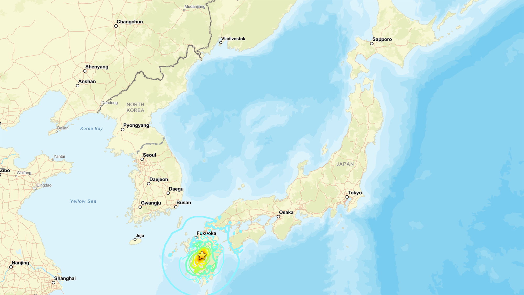
A powerful earthquake struck southwestern Japan Tuesday afternoon local time, collapsing part of a shopping mall, toppling a stone wall at the centuries-old Kumamoto Castle, and sending more than 150,000 people to evacuation shelters, the BBC reported.

The quake, which the U.S. Geological Survey (USGS) measured as a magnitude 6.8, hit at 4:27 p.m. local time near Kumamoto, a city of more than 700,000 people located on the island of Kyushu in southern Japan.

Thousands of homes lost power, and roads buckled across the region. The second floor of a shopping center collapsed, trapping shoppers inside, according to the BBC report; some of these people were evacuated and later hospitalized. A brief tsunami warning was issued and lifted within an hour.

A map of Japan showing its various cities and provinces

A map showing the location of the July 2026 earthquake. (Image credit: National Tsunami Warning Center (ATWC), Pacific Tsunami Warning Center (PTWC), USGS National Earthquake Information Center, PDE)

The USGS measurement is different from the magnitude 7.1 reported by the Japan Meteorological Agency, "primarily because the agencies are reporting different magnitude types," the USGS reported. While Japan is looking at local magnitude, the USGS measured the moment magnitude, which is derived from the physical size of the fault rupture and gives the "most reliable estimate of earthquake size" for large earthquakes, since local-magnitude scales can lose accuracy once a rupture grows big enough, the USGS reported.

These measurements are helpful, as "different magnitude types capture different characteristics of earthquake source processes," the USGS noted. Local magnitude, for example, reflects how strongly the ground shook nearby, while moment magnitude reflects the total energy released across the fault.

Why this quake is scientifically interesting

Japan sits atop one of the most active plate boundaries on Earth, where the Philippine Sea Plate dives beneath the Eurasia Plate. That process, known as subduction, is responsible for the massive, tsunami-generating earthquakes that periodically strike offshore Japan, and it's been studied intensively for decades.

But Tuesday's earthquake didn't occur at the boundary itself. Instead, the rupture happened within the Eurasia Plate, more than 60 miles (100 kilometers) inland from where the plates meet, Jeffrey Park, a theoretical seismologist at Yale University, told Live Science. Roughly 90% of earthquakes happen at plate boundaries, where the constant grinding of two plates builds up stress until a fault gives way. Quakes that strike farther inside a plate — sometimes called intraplate earthquakes — are rarer and less understood, though scientists suspect that stress transmitted through the plate can reactivate old, dormant faults far from the boundary that produced it.

According to Park, the fault in Tuesday's earthquake moved in a way that suggests the plate tore horizontally as it was twisted by subduction occurring at an angle.

The USGS describes this event as shallow strike-slip faulting: the two sides of the fracture slid past each other horizontally, rather than one side thrusting up and over the other. This faulting style, combined with the shallow depth of just 6 miles (10 kilometers) down, points to the same type of rupture behind Kyushu’s deadly 2016 Kumamoto earthquake sequence.

That inland location is also why the quake didn't generate a damaging tsunami, despite the brief precautionary warning. Tsunamis are produced when a big event ‪—‬ such as an earthquake, volcanic eruption or landslide ‪—‬ displaces water; the force from that displacement then propagates as a wave.

Tuesday's rupture stayed entirely on land, so it never pushed the seafloor up the way offshore quakes do. That's why the tsunami risk stayed low, even with the brief precautionary warning. Still, an inland quake isn't automatically off the hook: if the shaking triggers a landslide that spills into the sea, that alone can generate a tsunami.

The depth mattered just as much as the location. The quake was shallow enough to concentrate its energy near the surface, which Park said explains the structural damage.

"Because it is shallow it will cause more structural damage than a similar-sized event that might occur deeper and offshore," he told Live Science in an email.

Earthquake country

Several earthquakes have already clustered in the area, and numerous aftershocks are expected over the coming days. Japan experiences roughly 1,500 earthquakes annually, making it one of the most seismically active countries on the planet — a byproduct of sitting at the junction of several tectonic plates.

To protect itself, Japan has spent decades — and learned from painful lessons from disasters like the 2011 Tohoku earthquake and tsunami — engineering a response system built for exactly this scenario.

Bullet trains are programmed to halt automatically the instant seismic sensors detect a major earthquake, a safeguard Park pointed to as a defining feature of the country's earthquake readiness. That automatic shutdown extends to other transit and utility systems, part of a broader early-warning network that alerts the public within seconds of a quake's detection, giving people crucial time to take cover before shaking arrives.

Japan's investment in its infrastructure may help to explain why, even after a magnitude 7 event near a city of 700,000, Japan's death toll and damage have historically been far lower than those from comparable quakes elsewhere in the world.

Search-and-rescue efforts are continuing in Kumamoto, with CNN reporting that between 20 and 30 employees remained unaccounted for at the Aeon Mall in Kashima Town, where the building’s second floor had collapsed. Firefighters were also working to reach the site and contain nearby fires.

Colossal scars of 60 million-year-long continental collision streak across warped mountains in Pakistan — Earth from space

28 July 2026 at 11:38
QUICK FACTS

Where is it? Murgha Kibzai, Sulaiman Range, Pakistan [30.739354851, 69.50804296]

What's in the photo? Folded layers of rock left over from an ancient continental collision

Which satellite took the photo? NASA's Terra satellite

When was it taken? April 11, 2011

This striking satellite photo shows a multicolor "fan" of folded rocks sculpted by a longtime collision between two of Earth's tectonic plates.

The geological feature, known as an imbricate fan, is located around 3 miles (5 kilometers) east of the town of Murgha Kibzai in Pakistan's Balochistan province. The photographed section of folded rocks measures around 9 miles (15 km) across, but the fan stretches up to 55 miles (89 km) from end to end, well beyond the area in this image.

The dramatic structure sits at an altitude of around 5,000 feet (1,500 meters) in the Sulaiman Range, a series of mountains that covers around 2,500 square miles (6,500 square kilometers) of Pakistan and Afghanistan. ("Sulaiman" means "of Solomon," in reference to the biblical figure King Solomon, and the range's largest peak is Takht-e-Sulaiman, which translates to "Throne of Solomon.")

This is one of several unique features that emerged along the boundary between the Eurasian and Indian tectonic plates, which have been colliding for more than 60 million years. At one point during this tectonic tug-of-war, the two plates became somewhat intertwined, allowing the fan to take shape, according to NASA's Earth Observatory.

"As India moved northward, it began to rotate in a counter-clockwise direction, wrenching the northwestern part of the Indian plate backwards into part of the Eurasian plate," Earth Observatory representatives wrote. "The countervailing forces put the rocks of the Sulaiman Range in a unique compressional vice, causing many of its faults to curve and stretch in convoluted ways."

A wide-field image of the Sulaiman Range showing massive tectonic features spread out over a large area

The Sulaiman Range is full of unique geological features that were birthed by the collision between the Indian and Eurasian plates. (The imbricate fan is located on the far right of this wide-field image.) (Image credit: NASA/Terra)

The fan is made up of alternating layers of sandstone, which appear dark in the image, and limestone, which has a much lighter hue. These sedimentary rocks were formed by "thrust faults" that shot upward from the boundary between the Eurasian and Indian plates and became entangled as the boundary moved back and forth.

The satellite image is false-color, meaning it includes wavelengths of the electromagnetic spectrum that are not normally visible to humans. This helps to accentuate the differences between the two rock types, although they can also be easily distinguished with the naked eye. Pockets of vegetation appear in red throughout the image.

The photo is a small part of a larger, wide-field image (see above), which showcases several other intriguing geological features across the Sulaiman Range in false color.

Continental collision

The collision between the Eurasian and Indian plates became inevitable around 80 million years ago, when dinosaurs still ruled Earth, according to the Earth Observatory. At this point, the pair became locked on a collision course, with each plate moving more than 8 inches (20 centimeters) per year — around twice the speed of the fastest tectonic plates today.

Around 60 million years ago, the plates slowly slammed together. Normally, this would cause the smallest tectonic plate to sink below the other. However, the two plates' massive size meant neither receded. Instead, the continental crust along the boundary grew thicker, and the ground buckled, folded and pushed upward.

Satellite photo showing the warped shaped of the Sulaiman range

The Indian and Eurasian plates have been locked in a tectonic tug-of-war for more than 60 million years. Their collision birthed the Sulaiman Range, alongside the Karakoram and the Himalayas. (Image credit: Getty Images)

This process created not only the Sulaiman Range but also the Karakoram (a huge mountain range that spans the borders of China, India, Pakistan, Tajikistan and Afghanistan) and the Himalayas — the two tallest mountain ranges on Earth, according to the Earth Observatory.

This collision continued at full speed for around 30 million years, before eventually slowing down. However, the two plates are still technically colliding today, making the region a major earthquake hotspot.

See more Earth from space

A satellite photo showing a black blob of ancient lava surrounding a volcano in the middle of the Sahara desertShadowy tendrils of lava

A 2019 astronaut photo shows off ancient lava flows that once oozed down the jet-black slopes of the Toussidé volcano in northwestern Chad. An intriguing volcanic "skull" also lurks in the aerial image.

An astronaut photo of two near-identical volcanoes standing side-by-side on Indonesia's Java Island.Volcanic 'Twin peaks'

A 2021 astronaut photo shows the surprising similarities between Mount Sundoro and Mount Sumbing, which lie at the heart of Java, Indonesia.

An astronaut photo of the massifConcentric rocky rings

A 2025 astronaut photo shows a massif made of concentric mountain ridges in the Libyan desert. The rocky walls contain ancient artworks and are occasionally used to contain herds of grazing cattle.

Science word of the day: Seamount

28 July 2026 at 09:00

Science word of the day: Seamount

Pronunciation: SEE'-mount

What it means: A seamount is an undersea mountain that rises at least 3,300 feet (1,000 meters) above the seafloor but does not come close to breaking the surface. According to the National Oceanic and Atmospheric Administration, there are at least 100,000 seamounts in the oceans, and less than 0.1% of them have been explored. Seamounts typically form from volcanic activity, and many host dramatic communities of sea life ‪—‬ from coral, to sharks, to an assortment of weird jellyfish-looking things.

How to use it in a sentence: Every time marine biologists explore a seamount with their remotely operated vehicles, they seem to discover a new universe of strange and blobby deep-sea creatures.

Can you crack our science word of the day puzzle, Chain Word?

Science word of the day: Pando

27 July 2026 at 09:00

Science word of the day: Pando

Pronunciation: PAN'-doh

What it means: In Latin, "Pando" means "I spread." And boy, does it. Pando is a clonal stand of aspen trees in Utah that weighs about 13 million pounds (6 million kilograms), making it the world's heaviest living organism ever found. Its 40,000 trees cover 106 acres (43 hectares) in Fishlake National Forest, and they're all connected by a single, sprawling root system. Some DNA analysis suggests that this many-fingered megatree is tens of thousands of years old.

How to use it in a sentence: When you walk through Pando, what seems like a normal stroll through an aspen grove is actually a trip through a single, ancient living being.

Can you crack our science word of the day puzzle, Chain Word?

Science word of the day: Cenozoic

26 July 2026 at 09:00

Science word of the day: Cenozoic

Pronunciation: See-noh-ZOH'-ihk

What it means: The ascendency of mammals, the birth of the Himalayas, the diversification of birds ‪—‬ Earth's in its Cenozoic era, baby!

The Cenozoic is the geological era happening right now. It started 66 million years ago with the abrupt mass extinction known as the Cretaceous-Paleogene extinction event, when a massive asteroid hit Earth and wiped out the nonavian dinosaurs. It's been a busy few tens of millions of years, ushering in such hits as Earth's first cacti, whales and most (if not all) of the Grand Canyon.

How to use it in a sentence: The Cenozoic is called the Age of Mammals, but the University of California Museum of Paleontology in Berkeley would like you to know it could have been called the Age of Teleost Fish, if mammals weren't so dang self-centered.

Can you crack our science word of the day puzzle, Chain Word?

Science word of the day: Abiotic

23 July 2026 at 09:00

Science word of the day: Abiotic

Pronunciation: Ay-bye-AH'-tik

What it means: Abiotic means "without living organisms." Scientists typically use the term when referring to nonliving aspects of an ecosystem that affect organisms' growth or reproduction. Some abiotic factors might be light, water, fertilizer, nutrients or chemical elements, such as oxygen or sulfur. Others include the tides or rain. Sometimes, "abiotic" is used to describe the origin of a particular chemical. Abiotic methane, for example, comes from chemical reactions between rocks and water in Earth's crust, unlike biotic methane, which comes from decaying organic matter as well as microbes living in your gut.

How to use it in a sentence: A new "gold rush" of exploration is on for abiotic hydrogen, which forms when rocks react with water deep underground and could be a renewable, carbon-free fuel of the future.

Can you crack our science word of the day puzzle, Chain Word?

Science word of the day: Abiogenesis

22 July 2026 at 09:00

Science word of the day: Abiogenesis

Pronunciation: Ay-bye-oh-JEN'-ih-sis

What it means: Abiogenesis is the emergence of life from nonliving matter through chemical processes. Scientists still don't know exactly how abiogenesis happened on Earth. Theories range from lightning strikes that could have scrambled water, methane, ammonia and hydrogen into amino acids and sugars ‪—‬ the building blocks of life ‪—‬ to chemical reactions at deep-sea vents. Abiogenesis is not the same as spontaneous generation, which held that living organisms such as maggots formed directly from decaying matter. It was a compelling idea for anyone who had watched meat rot, but Louis Pasteur, inventor of pasteurization, disproved it in the 1860s by showing that microbes could only grow from preexisting microbes.

How to use it in a sentence: All life on Earth may owe itself to an incident of abiogenesis more than 3.7 billion years ago.

Can you crack our science word of the day puzzle, Chain Word?

Greenland meltwater will drive a 'strong weakening, but not a shutdown' of key Atlantic currents, study finds

Runoff from Greenland's rapidly melting ice sheet could severely disrupt currents in the Atlantic Ocean that regulate the global climate, researchers say. But the fresh water won't trigger the complete and irreversible collapse of the circulation that some research predicts, a new study suggests.

By 2100, Greenland meltwater could cause a reduction in the strength of the Atlantic Meridional Overturning Circulation (AMOC) equivalent to an additional 10% to 20% on top of the weakening that many scientists already expect for this huge system of currents, researchers found.

Previous research suggests the AMOC, which moves heat from the tropics to the Northern Hemisphere and cold water back south toward Antarctica, is at its weakest in more than 1,000 years due to Arctic ice melt and soaring ocean temperatures. Models indicate that the circulation will continue to weaken for decades to come, potentially unleashing freezing weather in Northwest Europe, additional sea-level rise along the U.S. East Coast and droughts around the equator.

Animation showing surface and bottom currents across the world's oceans.

The AMOC loops around the Atlantic Ocean, bringing warm waters north along the ocean's surface and cold waters south along the ocean floor. (Image credit: NASA/Goddard Space Flight Center Scientific Visualization Studio)

The new study revealed that by 2300, Greenland's ice sheet could cause a whopping 40% of AMOC weakening on top of the declines projected by some climate models if we continue to cook the planet. The results highlight the effects on the AMOC of a growing freshwater pulse from Greenland that most climate models currently don't take into account, the authors said.

"By the year 2100, yes, we have something, but the greatest fraction is what we add later," study co-author Jost von Hardenberg, a professor in the Department of Environment, Land and Infrastructure Engineering at the Polytechnic University of Turin in Italy, told Live Science.

Meltwater from the Arctic and Greenland slows the AMOC by preventing the formation of deep currents in the North Atlantic that drive the circulation south toward Antarctica. Deep currents form when masses of cold, salty water sink to the seabed, but inputs of fresh water and rising water temperatures are blocking this step by diluting and warming surface waters.

While Arctic meltwater is commonly integrated into climate simulations, researchers have been slower to include runoff from the Greenland ice sheet in models, partly because this runoff may not be as disruptive as Arctic meltwater on shorter timescales, von Hardenberg said.

"In order to represent correctly the Greenland melt, you need a specific, dynamic model for the Greenland ice sheet. It's nice to have, but it requires a lot of resources to develop," von Hardenberg said

The Community Ice Sheet Model version 2 (CESM2) is one of the few available simulations of the Greenland ice sheet. For the study, von Hardenberg and his colleagues used a global climate model called EC-Earth3, which does not include the Greenland ice sheet. The team added the ice sheet from CESM2 to explore how it might affect the AMOC over the next few centuries. Adding the ice sheet separately enabled them to compare AMOC weakening with and without Greenland, clearly revealing the impact of the ice sheet on the AMOC's strength.

The results, published June 19 in the journal Science Advances, suggest the Greenland ice sheet will have a big influence on Atlantic ocean currents, especially after 2100.

"Greenland starts really melting strongly only after that date," von Hardenberg said. "If you go farther in our simulation — we go up to the year 2300 — that is also when this meltwater really becomes extremely strong."

Yet unlike other studies that show the AMOC collapsing irreversibly under climate change, in this model, the circulation recovered once the team switched off the meltwater or dialed down greenhouse gas emissions. Both the simulations that didn't include the Greenland ice sheet and those that did had similar results, recovering partially when the meltwater was turned off and fully when greenhouse gas emissions were stopped.

The recovery in the model suggests that the AMOC is more stable than previously thought and doesn't suddenly flip from an active state into a collapsed one, von Hardenberg said. "It's consistent with a strong weakening, but not a shutdown," he said.

Overall, the findings show that it is important to include the Greenland ice sheet in climate models — something von Hardenberg and his colleagues are planning to do in the next version of the EC-Earth3 model.

"It's really something which is worthwhile doing to better constrain the uncertainty of these future simulations," von Hardenberg said. "If we have a larger set of models which include this component, we will be in a better position to try to answer the question, 'How much do we expect AMOC to decrease in different scenarios?'"

Other experts agreed that integrating the Greenland ice sheet in climate models will increase the accuracy of AMOC predictions.

"What makes the study particularly interesting is that it directly tests a process that has often been highlighted as an important source of uncertainty in future AMOC projections," said Jonathan Baker, a senior climate scientist at the Met Office in the U.K. who was not involved in the study.

The results are consistent with previous research showing that Greenland meltwater causes additional AMOC weakening, but whether the system could collapse is still uncertain, given that the team used only one model, Baker told Live Science in an email. "Repeating these experiments across a wider range of models will be important to assess how robust the findings are," he said.

Nicholas Foukal, an assistant professor at the University of Georgia's Skidaway Institute of Oceanography who was not involved in the study, said he doesn't think the use of a single model limits the analysis.

"I think this result is robust and I am glad to see the authors come to this conclusion in such a high-resolution and realistic coupled climate model," Foukal told Live Science in an email. "This finding also agrees with other modeling results that require immense amounts of fresh water, much more fresh water than is available on Greenland, to cause irreversible change in the AMOC."

However, a third expert said the model used in the study is unrealistic, because its parameters make the AMOC more resilient than those of other models. Therefore, the study should be replicated in other models to draw unbiased conclusions.

"While the experiment reported is interesting, its outcomes are neither surprising nor should be interpreted as exemplary for the whole model ensemble," Sybren Drijfhout, a professor of physical oceanography at the University of Southampton in the U.K., told Live Science in an email.

Researchers should investigate the impact of the Greenland ice sheet on the AMOC further, von Hardenberg said. "It would be interesting in the future to check it [the AMOC's recovery with Greenland meltwater] with other models, but of course it's encouraging to see it in one case," he added.

Giant, milky-green vortex swirls across massive 'cryptodepression' lake in Southern Europe — Earth from space

21 July 2026 at 08:00
QUICK FACTS

Where is it? Lake Skadar, Montenegro and Albania [42.201087364, 19.303135741]

What's in the photo? A giant, milky-green swirl on the lake's surface

Who took the photo? An unnamed astronaut on board the International Space Station

When was it taken? Feb. 21, 2020

This eye-catching astronaut photo shows a cloud of sediment swirling into a giant, milky-green vortex in one of Europe's largest lakes.

Lake Skadar (also known as Shkodër, Shkodra or Scutari) is the largest lake in Southern Europe, with a surface area between 140 and 200 square miles (360 to 520 square kilometers), depending on the time of year. It is situated on the border between Montenegro, which surrounds the western half of the lake (left in the photo), and Albania, which encircles the lake's eastern shore. The body of water is split 65% to 35% in Montenegro's favor.

The lake's main water source is the Morača River, to the northwest, and its biggest outlets are the Bojana and Drin rivers, which start at the lake's easternmost point and eventually drain into the Adriatic Sea, which is partially visible in the bottom left of the photo. Skadar's southern shore is also hugged by a lofty mountain range, known as the Dinaric Alps.

During late winter and early spring, the lake's water level rises, and it usually fills with a milky-green substance that often gets whipped into a vortex by a combination of wind-driven surface currents and the natural flow of water between the lake's major inlets and outlets.

The swirling material looks very similar to blooming algae, but it is actually made of sediments — predominantly limestone and dolomite — that wash into the lake from the Dinaric Alps and other nearby mountains as the snow melts.

An aerial view of Lake Skadar with the Adriatic Sea in the background

Lake Skadar formed millions of years ago and was once connected to the Adriatic Sea (visible in the background of this image). (Image credit: Wikimedia)

Skadar is a karst lake, meaning it was once a cave system that flooded and eventually collapsed, likely because the caves were made from the same easily erodible rocks that now swirl on the lake's surface, according to NASA's Earth Observatory. The lake is a "cryptodepression" because most of the lake's floor is below sea level.

The lake originally formed during the Cenozoic Era (66 million years ago to the present), according to the International Lake Environment Committee Foundation's World Lake Database. It is home to several small islands, some of which can be seen in the photo along the lake's southern shore. These include Beška, which is home to a pair of 600-year-old churches, and Grmožur, where the remains of a 19th-century fortification loom above the lake's surface.

The shipwreck of a paddle steamboat, named Skanderbeg, lies along the lake's western shore. Local partisans sank the vessel in 1942 after Italian soldiers commandeered it during the Axis occupation of Yugoslavia in World War II. When the lake's water levels are at their lowest, part of the shipwreck rises above the surface.

Skadar Lake is a biodiversity hotspot and has protected wildlife status on both sides of the Montenegro-Albania border. It is a particularly important site for birds; more than 280 avian species call it home, including the Dalmatian pelican (Pelecanus crispus) and several endemic species, according to BirdLife International.

The lake also hosts around 50 freshwater snail species ‪—‬ more than any other lake on Earth, according to a 2013 study.

A satellite photo of a lake in the desert with dark green swirling waters from an algal bloomToxic bloom in 'Pyramid Lake'

A 2024 satellite photo shows an unusually active bloom of toxic cyanobacteria swirling in the water of Nevada's Pyramid Lake.

Large swirls of green seen on the ocean's surface from spaceMystery swirls in Baltic Sea

This 2018 satellite photo shows an unknown substance swirling across the Gulf of Gdańsk in Poland. Scientists were shocked to later discover what it really was.

An astronaut photo of a deep blue lake in Turkey with milky light blue swirls spinning in the waterMilky plumes in giant 'soda lake'

A 2016 astronaut photo shows surprising plumes of milky material swirling in the waters of Turkey's Lake Van, the largest alkaline lake on Earth.

Science word of the day: Autotroph

19 July 2026 at 09:00

Science word of the day: Autotroph

Pronunciation: AW'-tuh-trohf

What it means: Autotrophs are organisms that can feed themselves with inorganic substances such as light (for plants) or methane (certain microbes). Autotrophs were the first single-celled life-forms to colonize the planet, thriving on chemicals bubbling up from the subsurface at deep-sea vents or figuring out how to harness the sun for energy. Heterotrophs (like you, me and all fungi), arrived on the scene later to feast on these DIY-ers.

How to use it in a sentence: Stromatolites, microbial mats built by cyanobacteria, are autotrophs that thrived in ancient shallow seas.

Can you crack our science word of the day puzzle, Chain Word?

'These are striking forecasts': Super El Niño keeps getting even more likely, and it could bring a humanitarian crisis

17 July 2026 at 16:56

This year's El Niño will almost certainly become the strongest ever recorded, an analysis by a prominent climate researcher has warned. Though other scientists have cautioned that it's still too early to say what it will unleash.

Dynamical models now assign a 90% chance of the 2026-2027 El Niño being an all-time record event, sending temperatures in the Pacific Ocean up to around 3.6 degrees Celsius (6.5 degrees Fahrenheit) above average, according to an analysis by Zeke Hausfather, a research scientist at Berkeley Earth and an author of the Intergovernmental Panel on Climate Change's Seventh Assessment Report.

As the warm phase of a multiyear natural climate pattern, the El Niño could bring unprecedented temperature extremes to an already-warming world. The natural climate pattern is infamous for boosting global temperatures and fueling disruptive weather events such as floods and droughts.

A strong El Niño doesn't guarantee more severe weather impacts. The current El Niño models are also imperfect predictions of what's to come, and we won't know the true nature of this El Niño event until it peaks, likely later this year. However, forecasters have been warning of potentially supercharged El Niño conditions for months, and as more data emerges, there are more reasons to prepare.

According to projections by the World Meteorological Organization, the current El Niño — officially declared on June 11 — is on track to rapidly develop into a "strong" event between July and September. The National Oceanic and Atmospheric Administration's (NOAA) Climate Prediction Center now predicts a more than 80% likelihood of very strong El Niño conditions taking hold by the end of the year, ranking this El Niño event among the largest in the historical record.

"These are striking forecasts," Emily Black, a professor of terrestrial processes and climate at the University of Reading and a senior scientist at the National Centre for Atmospheric Science in the U.K., told Live Science in an email. "El Niño forecasts always come with uncertainty, but the level of agreement between models at this time of year, combined with the observed warming already underway in the tropical Pacific, means this should be taken very seriously."

"The important point is that a very strong El Niño would substantially shift the odds of damaging weather in many parts of the world, particularly in the Global South — with severe impact on livelihoods," Black added.

The International Rescue Committee, a humanitarian organization, has warned that the intense El Niño conditions threaten to unleash severe flooding and drought across East Africa and Asia, hitting some of the most vulnerable communities, Al Jazeera reported Tuesday (July 14).

El Niño continues and will strengthen through the end of the year, with a 97% chance it will persist through early spring 2027. An #ElNino Advisory remains in effect. #ENSO https://t.co/5zlzaZ1aZx pic.twitter.com/ASC46wKOn4July 9, 2026

During El Niño, warmer waters gather east of the equatorial Pacific, forcing the jet stream south. In the U.S., this typically brings warmer, drier conditions to the Northeast, while the Gulf Coast and Southeast experience an increased risk of flooding. Globally, the net result of the warmer waters is more heat in the atmosphere, on top of the temperature rise from human-driven global warming.

"El Niño is a natural climate phenomenon, but it is now happening against the backdrop of a much warmer planet," Black said. "That matters because a strong El Niño releases heat and energy into an already warmed world."

"This does not mean every impact can be attributed simply to El Niño or simply to climate change," Black added. "The two interact. El Niño can load the dice towards drought in some regions, flooding in others, marine heatwaves, disrupted monsoons and unusually high global temperatures. Climate change makes many heat extremes more severe and can intensify heavy rainfall because a warmer atmosphere can hold more moisture."

The last El Niño event occurred between 2023 and 2024. Both years broke temperature records, with 2024 becoming the hottest on record and the first to breach the 1.5-degree- Celsius (2.7 degrees Fahrenheit) warming limit set by the 2016 Paris Agreement. The current El Niño is forecast to be more intense than the one in 2023 and 2024, with the projected "very strong" status putting it in a different class of severity.

A flooded street with a man sitting on a floating barge.

Residents wade through stagnant water over a flooded road at Kohoto estate in Naivasha, Kenya on November 17, 2025 (Image credit: Tony Karumba/AFP via Getty Images)

The strongest El Niño in history?

Hausfather's analysis reports that there's around a 90% chance that the current El Niño will be the strongest ever recorded, with data from multimodel forecasts suggesting that it may obliterate the previous record.

"With the July runs now in from 667 ensemble members across 14 different seasonal forecast models, it looks like this year's El Niño is not only very likely to be the strongest event since reliable records began ‪—‬ it may end up the strongest by a truly mind-blowing margin," Hausfather wrote in The Climate Brink Substack post published Monday (July 13).

NOAA recognizes El Niño conditions when the eastern tropical Pacific Ocean is at least 0.5 C (0.9 F) warmer than the historical average, while wind, surface pressure and rainfall in the region are also consistent with El Niño conditions. The El Niño is then categorized as weak, moderate, strong or very strong. A very strong El Niño (above 2 C, or 3.6 F, warmer than the historical average) is often nicknamed a "super" El Niño, though it's not a scientific term.

The July models suggest that temperatures will likely sail past 2 C above average in the coming months and could potentially even exceed 3.5 C (6.3 F) above average by the end of the year. This is based on newly introduced sea surface temperature forecasts that account for rising background temperatures that can inflate El Niño warming figures. In the traditional and most widely used indices, the temperature-anomaly forecasts cluster closer to 4 C (7.2 F), with some even exceeding 4 C.

A heatmap of the Earth showing sea surface heights with red areas around the equator.

This Sentinel-6 Michael Freilich satellite image captures the massive wave of warm water and higher-than-usual sea surfaces (red) that stretched across the Pacific on June 8, just a few days before El Niño was declared. (Image credit: Data for the map were acquired by the Sentinel-6 Michael Freilich satellite and processed by scientists at NASA’s Jet Propulsion Laboratory (JPL).NASA Earth Observatory/Lauren Dauphin)

In The Climate Brink Substack, Hausfather noted that the multimodel median for the event's peak is currently forecast at 3.6 C (6.5 F), or around 0.8 C (1.4 F) hotter than the prior record holder (2.75 C, set in the 2015-2016 El Niño event). Hausfather wrote that around 91% of ensemble members (individual computer models) have this El Niño exceeding the 2015-2016 record at their peak — around 77% likelihood in the newly introduced indices.

However, Black stressed that the models are still estimates, and not guarantees.

"It is certainly plausible that this could become a record-breaking El Niño, and the latest forecasts make that a real possibility rather than a remote one," Black said. "However, I would still be cautious about treating any probability estimate as a certainty."

"There are two reasons for caution," she added. "First, this event has not peaked yet, and El Niño events usually reach their maximum strength later in the year. Second, 'strongest ever recorded' depends on the index, dataset and baseline used."

"Impacts are what matter"

The most severe El Niño events have left a trail of devastation in their wake. For example, the 2015-2016 El Niño saw a record-breaking hurricane season in the central North Pacific, severe drought in the Caribbean and Ethiopia, and, of course, abnormally hot global temperatures, according to NOAA's Climate.gov. If the forecasts pan out, the current El Niño will match or exceed the 2015-2016 event, as well as an even more infamous super El Niño that occurred between 1877 and 1878, long before modern recordkeeping of El Niño began in 1950.

The 1877-1878 event likely fueled an extreme drought that fed into the 1876-1878 global famine, which ultimately killed more than 50 million people — making it among the worst humanitarian crises in history. However, the disaster was far from just an environmental one, with extractive colonial agricultural policies helping to create conditions for a massive humanitarian crisis. Nonetheless, the famine highlights what can happen when environmental and socioeconomic factors converge.

Even though the world has changed a lot since the 19th century, experts have said a super El Niño could still cause severe shocks to our food systems. This is especially true at a time when researchers say food insecurity is not just confined to low-income countries and that climate change is already pushing agricultural systems to the brink.

The El Niño-Southern Oscillation cycle triggers a warm El Niño and then a cold La Niña roughly every two to seven years, with each phase typically lasting around nine to 12 months. Carbon Brief has predicted that 2026 is likely to be the second-warmest year on record, with the intensifying El Niño increasing the likelihood that 2027 will be the warmest year ever recorded.

The strength of an El Niño event does not necessarily correspond to the size of its influence or impact, according to the Climate Prediction Center. More severe events typically, but not always, increase the certainty of expected impacts. Black believes the impact of an El Niño event is more important than where it ranks in the observational record.

"Records are compelling, but impacts are what matter," Black said. "Even if it falls just short of a record, a very strong El Niño can still have serious consequences. Finally, these forecasts are concerning, but they are also useful: they give societies time to anticipate possible impacts and act before the worst effects are felt."

Heaven Lake: China's deepest lake sits atop a colossal volcano and belongs mostly to North Korea

QUICK FACTS

Name: Tianchi Lake, or Heaven Lake

Location: China-North Korea border

Coordinates: 42.0091, 128.0593

Why it's incredible: It is the deepest lake in China and sits at the top of a giant volcano.

Heaven Lake is a crater lake at the top of Mount Changbaishan (also called Changbai Mountain) — a colossal, dormant volcano on the border between China and North Korea that formed through successive eruptions over the past 2.6 million years.

Known in China as Tianchi, the lake is the highest and largest crater lake in Northeast Asia, according to UNESCO. It is also the deepest lake in China, according to a study published in March. The lake sits at an elevation of around 7,200 feet (2,200 meters), covers roughly 3.6 square miles (9.2 square kilometers), and has a maximum depth of 1,224 feet (373 m), according to the study.

Heaven Lake is surrounded by 16 peaks that belong to Mount Changbaishan. The lake fills a caldera created by past eruptions, the biggest of which was the "millennium eruption" that took place in A.D. 946 and remains one of the largest eruptions in modern history.

Water started to pool on Mount Changbaishan's summit after the prehistoric Tianwenfeng eruption, which scientists dated to between 70,000 and 40,000 years ago. Heaven Lake has periodically emptied and refilled since then due to precipitation, snowmelt, and an active geothermal system beneath the volcano that forces water up through fault lines.

Although hundreds of reports in the early 2000s claimed there was a creature with a head shaped like that of a horse living in the water, scientists have repeatedly said they are skeptical that any large creature could survive in Heaven Lake.

Mount Changbaishan is one of the best-preserved stratovolcanoes from the past several million years, according to UNESCO. Stratovolcanoes, also known as composite volcanoes, are volcanic mountains built from alternating layers of solidified lava, volcanic ash and rocky debris. Mount Changbaishan is an "open-air classroom for volcanism" because it recorded the different stages of multiple eruptions in astounding detail.

In North Korea, Mount Changbaishan is known as Mount Paektu or Paeku Mountain, meaning "white-topped mountain." The volcano's Chinese name means "forever white mountain."

China, North Korea and South Korea have clashed over the volcano in the past, as the mountain holds cultural and geopolitical significance for the three countries. Two border treaties between China and North Korea in 1962 and 1964 divided the volcano and Heaven Lake roughly down the middle, with North Korea securing 54.5% of the lake.

In the 2000s, China moved to develop the region around the volcano, opening the Mount Changbai Airport and the Mount Changbai Eastern Railroad to connect the region with the rest of the country.

A geological park surrounding the Chinese site of the volcano was officially designated a UNESCO Global Geopark in 2024.

Discover more incredible places, where we highlight the fantastic history and science behind some of the most dramatic landscapes on Earth.

'This was one of the most arduous expeditions I've ever done': Scientists confirm that 15-mile-wide pit found on Google Maps is ancient meteor crater

A large pit discovered by an amateur astronomer on Google Maps in 2024 is actually a 390 million-year-old meteor impact crater, scientists have confirmed.

Joël Lapointe was planning a camping trail through Quebec's Côte-Nord region when he stumbled upon a large indentation in the terrain, CBC reported at the time. The pit, centered around Lake Marsal, was about 25 kilometers (15.5 miles) in diameter and a near-perfect ring — it didn't seem like a normal ditch. Lapointe eventually got in touch with French geophysicist Pierre Rochette, who said that the surrounding topography was "very suggestive" of an impact crater.

Initial testing of samples retrieved from the site contained a mineral called zircon often formed during meteor impacts. However, zircon's presence alone was not enough to prove the crater's extraterrestrial origin story. So a team of scientists had visited the pit in person.

"One of the key things we look for is evidence for shock metamorphism, which can only occur due to the immense pressures created by asteroid or cometary impacts — or nuclear explosions," Gordon Osinski, a professor of planetary geology at Western University, told Live Science in an email. "Most of these features are microscopic, so you can only confirm in the lab with samples."

But there is one feature Osinski said can be seen with the naked eye: grooves or lines in the rock's surface called shatter cones, which are caused by shockwaves passing through the ground.

In October 2025, Osinski and a team of geologists visited the site to investigate whether any of these features were present. "This was one of the most arduous expeditions I’ve ever done — and I’ve done 25 expeditions to the Arctic and 6 continents," he said. "The terrain was incredibly rough and rugged, plus [there were] lots of bugs."

But they eventually found what they were looking for — shatter cones. They also discovered big cliffs of impact melt rock, created by the intense temperatures and pressures produced by a meteor impact. "You can melt literally tens of cubic kilometres of the Earth's crust when you get a big enough asteroid hitting," Osinski told CBC.

Taking samples from the rocks, the team dated the crater at 390 million years old.

A) Shatter cone at the center of the structure. B) melt rock 4 km (2.5 miles) west of the structure center

A) Shatter cone at the center of the structure. B) melt rock 4 km (2.5 miles) west of the structure center (Image credit: Gattacceca, J. et al.)

Osinski, who runs a website called Impact Earth dedicated to verifying meteor impact sites, is used to getting emails about strange looking satellite images. "I get lots of messages from the public thinking they have found a crater and 99/100 turn out not to be the case," he told Live Science. "This is one of those rare examples that shows this is possible."

So far, we know of roughly 200 impact craters on Earth, 31 of which have been found in Canada. "Typically about 1 or 2 craters are discovered per year, but these are typically less than 5-10 km [3 to 6 miles] in size," Osinski said. "[A crater of this size] is pretty rare."

The last meteor crater confirmed in Canada was in 2010.

After the new investigation confirmed the pit was punched out by a meteor impact, Osinski, Rochette and their team named it Uhaachatik Crater following discussions with the Ekuanitshit Innu council, a council representing the indigenous people in the area. The researchers will present their work at the Annual Meeting of the Meteorological Society in Germany next month.

Speaking to Radio-Canada, Lapointe said that he was very happy to hear his discovery had been confirmed as a genuine meteor crater. "It's not every day that an ordinary citizen finds a 390-million-year-old crater," he said. “I encourage everyone to not ignore intuition or an observation, even if it isn’t part of your field of expertise.”

Osinski and the team will continue their work on the collected samples to learn more about the impact site. "Any crater discovered offers us insight into how craters form and the effects that they can have on Earth’s geology, biology, and climate," he told Live Science.

'It affects your daily life suddenly': Sea level researcher explains why once-in-a-century floods could become the new normal

14 July 2026 at 10:03

Extreme coastal flooding events are occurring far more frequently in our warming world than ever before, threatening countless communities that will only become more vulnerable as climate change intensifies.

A recent study found that once-in-a-century flooding events now strike on our planet about once a decade. The study, published June 10 in the journal Nature Climate Change, also found that human-driven climate change has quadrupled the frequency of coastal sea level extremes since 1900.

The findings were released alongside another study by a separate team, published in the journal Science Advances, that found human-caused sea level rise was clearly measurable at 97% of sites sampled around the world, and was responsible for around 58% of the observed daily extreme water level exceedances between 2000 and 2018. In other words, human activities are the primary drivers behind sea level extremes — which include storm surges, high tides and rising sea level anomalies.

As the ocean's potential to devastate coastal communities surges, Live Science spoke with Sönke Dangendorf, lead author of the Nature Climate Change study, to learn more about what's to come. Here's what he had to say.

Patrick Pester: How do you separate human-driven sea level rise from natural forces?

Sönke Dangendorf: The absolute basis for doing these kinds of investigations is to work with observations, but observations are unfortunately sparse. We have a few more than 100 tide gauges [distributed worldwide] that offer long, century-scale records of sea level change since the early 20th century. We see that sea levels are changing at those locations, but we cannot tell a whole lot about what is happening elsewhere. So, what we can do is use the same climate models that we use to produce future projections of sea level change.

If you compare observations with the models, then the models need to be able to reproduce what the observations have shown. That was the first step we did, and indeed we proved in this study that the climate models are capable of reproducing observed climate. The nice thing with climate models then is that if you are able to reproduce what has been observed, you can start doing experiments. For instance, you can keep greenhouse gases constant in the modeling and then assess the influence of natural climate variability on the changes that we have observed. That's what we did in the study.

We found that we have seen already a 12-fold increase on average globally in what used to be a once-in-100-year event in 1900. And when we do these forcing experiments, we have also seen that anthropogenic forcing [human-driven change], in particular since the 1970s, has become the dominant force.

PP: What does this mean for coastal communities around the world?

SD: A couple of centimeters of sea level rise doesn't sound like a whole lot in theory, but if you live along the coast, it hits you much harder than you might think. Just an example: I used to live along the U.S. East Coast in Norfolk, Virginia. The community was built along the water, and they used to be fine in the 1950s and 1960s; they wouldn't see flooding at all, or maybe just once every five or six years. But due to sea level rise, what happens now is that high tide leads to flooding. You see flooded streets, and that affects your commute, so people increasingly cannot make it to work.

It affects your daily life suddenly. And then it makes it very hard for you and your coastal community because you have increasing insurance costs — the accumulated costs of these events can easily be as much as a major hurricane making landfall. So, this is a daily experience that many people already have, and it's a direct impact of sea level rise.

With respect to what we assessed in these more extreme events, people may absorb a once-in-a-100-year event once in their lifetime. They may experience something like a Storm Sandy, and they may be able to recover from that, but if you think about recovering from that basically every eight years — the frequency of these events nowadays compared to 1900 — that's of course way more difficult and not feasible for many people.

PP: What can we do?

SD: We can adapt. The silver lining here is that we have shown humans are the dominant forcing factor behind these changes. That's the silver lining because it means if we react, we can do something about it.

The reaction to changes in climate is often delayed, so we have sea level rise that we are already committed to. For instance, if you look into projections, they all agree with respect to what happens until around 2060, independently of how much greenhouse gases are emitted. There's no way around that. We could stop emitting greenhouse gases today, and we would still experience it. So, we need to adapt to that sea level rise, but if we mitigate climate change, if we stop emitting greenhouse gases, then we can avoid dangerous sea level rise, and that's very important.

A photo of flooding outside someone's home.

Flooding is becoming more severe and disruptive as our planet warms. (Image credit: Roberto Westbrook via Getty Images)

PP: What will the world look like in 2060 with the committed sea level rise?

SD: According to the last IPCC [Intergovernmental Panel on Climate Change] report, what used to be a once-in-a-100-year event in the present day will occur annually at 19% to 31% of tide gauge locations by 2050. So, at about a quarter of the locations, you will experience these once-in-a-100-year events annually, and that is something that is just mind-blowing.

The changes are happening much quicker in low-latitude locations. The reason is that in the tropics you typically have a less variable climate. You don't have these massive swings all the time. For instance, in the North Sea, we have a storm season, and we have huge tide ranges. We are already adapted to pretty massive changes of multiple meters, so a couple of centimeters of sea level rise do not play out that hard, but in the tropics, where it's more calm, it makes a huge difference.

As an analogy, think about two hurdle runners. You have one hurdle runner that's compared to the tropics; he jumps very consistently but always below the hurdle, so he never makes it over. Then you have another hurdle runner that's the North Sea type of guy. His jumps are very variable. Sometimes he's very high and makes it over that hurdle, but very often he also jumps very low. Now think about lowering that hurdle, which is comparable to increasing sea levels. Suddenly, that hurdle runner who is very consistent makes it over all of the time, while the guy from the North Sea may jump over the hurdle a couple more times, but he also still has the very extreme lows. So, the constant jumper is way more sensitive to these changes.

Editor's note: This interview has been edited and condensed for clarity.

Space shuttle photobombs Earth for the final time, 15 years ago — Earth from space

14 July 2026 at 09:13
QUICK FACTS

Where is it? Over the Bahamas

What's in the photo? The space shuttle Atlantis, preparing to dock with the International Space Station (ISS)

Who took the photo? An unnamed astronaut on board the ISS

When was it taken? July 10, 2011

This stunning astronaut photo shows the last time one of NASA's iconic space shuttles photobombed astronauts' view of Earth as the spacecraft docked with the ISS.

NASA's Space Shuttle Program included five plane-like spacecraft — Columbia, Challenger, Discovery, Atlantis and Endeavour — which collectively completed 135 missions between 1981 and 2011, racking up more than 32,000 hours in space. During that time, they helped to construct the ISS and, later, ferry astronauts to and from the station. The space shuttles also helped to deploy and maintain several other important spacecraft, including the Hubble Space Telescope.

The last space shuttle to fly was Atlantis, which successfully completed 33 missions (the second-highest total, behind Discovery).

This photo shows Atlantis approaching the ISS for the last time as it passed over the distinctive turquoise waters of the Bahamas. The space shuttle's bay doors are open, exposing its cargo area. This was standard procedure for all space shuttles once they reached low Earth orbit because it prevented the spacecraft's radiators from overheating.

The open doors also enabled the shuttle's docking mechanism, located within its cargo bay, to attach to the ISS, thus creating a pressurized seal so that astronauts could move between the two spacecraft.

Atlantis' final flight began on July 8, 2011, when it launched from the Kennedy Space Center in Florida vertically strapped to a massive fuel tank and a pair of rocket boosters. It returned to Earth on July 21, gliding down to land onto a runway at the launch site. (The spacecraft is now on display at the Kennedy Space Center Visitor Complex.)

In addition to helping construct the ISS, NASA's space shuttles visited Russia's Mir space station, serviced Hubble, and deployed both the Magellan probe to Venus and the Galileo probe to Jupiter. In total, the space shuttle orbited Earth 4,848 times, traveling nearly 126 million miles (203 million kilometers) — more than 525 times the distance between Earth and the moon.

Astronaut photos of the space shuttles were popular because they offered "punctuated snapshots of distinct places on Earth" that were "framed by a human eye," NASA representatives wrote in 2011. "These images speak to people."

Photo of Atlantis touching down for the final time on a runway at the Kennedy Space Center at night

Atlantis touched down at the Kennedy Space Center on July 21, 2011, brining the 30-year Space Shuttle program to an end. (Image credit: NASA/Bill Ingalls)

While the Space Shuttle Program achieved a lot during its 30-year history, it famously suffered two tragedies: the 1986 Challenger and 2003 Columbia disasters, which killed all crewmembers on board.

NASA eventually canceled the program in 2011, citing the high cost of maintaining the aging spacecraft and a reduced need for the vehicles after the completion of the ISS the same year. To this day, the space shuttles remain the only winged spacecraft to carry humans into space.

See more Earth from space

Close up satellite photo of the Great Bahama Bank showing the colorful folds of the sandbanks and seagrass'Painting-like' ripples in the Bahamas

A 2020 satellite photo shows off the ethereal beauty of submerged sandbanks and seagrass beds in the Great Bahama Bank.

A satellite photo showing a group of islands in the Pacific Ocean with a glowing green ring of algae surrounding themGlowing ring of algae in New Zealand

A 2026 satellite photo captured a gleaming halo of phytoplankton encircling the remote Chatham Islands and a hidden underwater plateau.

A beautiful light blue plume swirling in the sea off Key WestArctic blast paints plume in Florida

A 2026 satellite photo captured a stunning scene of sediment swirling across the West Florida Shelf after an extreme cold snap.

Venezuela's devastating 'earthquake doublet' holds a warning for California's San Andreas Fault

12 July 2026 at 13:00

The two major earthquakes that struck Venezuela just 39 seconds apart on June 24 had slightly different epicenters in north-central Venezuela. The first (M7.2) struck near San Felipe, and the second (M7.5) near Yumare, leaving thousands dead and thousands more injured, according to government officials. But beyond the devastation, the sequence opened a rare scientific opportunity: Researchers think the unusual "earthquake doublet" could offer new insight into how large fault systems interact and how some of the most destructive earthquakes grow.

Large earthquakes are typically followed by smaller aftershocks. But particularly intense events can also alter stress on nearby faults ‪or along the same fault, ‪triggering another major earthquake.

These scenarios are infrequent but not unprecedented. The 2023 sequence in Kahramanmaraş, Turkey, and the 1997 earthquake doublet in Harnai, Pakistan, are two well-known examples.

The Venezuelan sequence also reinforces an emerging consensus among seismologists: that treating faults as isolated structures may underestimate the destructive power of quakes in regions where multiple tectonic faults meet, as they do both in Venezuela and around California's San Andreas Fault system. That's a problem, because many of the seismic hazard models in California do not account for those multi-fault interactions.

A natural laboratory for understanding major earthquakes

The fault system involved in the Venezuelan earthquake ‪—‬ which includes the Boconó, Morón, San Sebastián and El Pilar faults ‪—‬ shares several key characteristics with the San Andreas Fault. Both are right-lateral strike-slip fault systems ‪—‬ in which the crustal blocks slide horizontally past each other ‪—‬ located along the boundary between two tectonic plates: the South American and Caribbean plates in Venezuela, and the Pacific and North American plates in California.

Despite these similarities, researchers caution that the two systems differ in important ways.

"The main difference is that the Venezuelan plate boundary has a much more complex fault architecture," Julián García Mayordomo, a senior scientist in the Geological Hazards and Climate Change Department at the Geological and Mining Institute of Spain, told Live Science.

The difference stems largely from the Maracaibo block, whose interaction with surrounding faults creates a much more intricate plate boundary than California's.

"The other difference is the speed at which the plates move," García Mayordomo pointed out.

In Venezuela, the tectonic plates move past each other at about 0.8 inches (20 millimeters) per year, compared with roughly 1.2 inches (30 millimeters) along the San Andreas Fault. Faster plate motion allows tectonic stress to accumulate more quickly, which influences how often large earthquakes occur over long timescales, but not when the next one will strike.

aerial view of the san andreas fault

An aerial view of the San Andreas Fault in California. (Image credit: Kevin Schafer/Getty Images)

Along the San Andreas Fault, magnitude 7 or larger earthquakes occur, on average every 100 to 200 years, although the frequency of recurrence varies along the fault. The last major rupture in Southern California was the magnitude 7.9 Fort Tejon earthquake in 1857. In Venezuela, estimated slip rates suggest recurrence intervals of one to two centuries. The region experienced two devastating earthquakes in 1812, part of a multiple-rupture sequence that included events of magnitude 7.5, 7.2 and 6.5, and a 2018 study concluded that the Boconó Fault had already accumulated enough strain to generate another major earthquake.

However, these are statistical averages. The recurrence of large earthquakes is highly irregular and depends on a multitude of factors, many of which we still don't fully understand. So a major event could occur in 100 years ‪—‬ or even tomorrow.

Looking beyond individual faults

This uncertainty is precisely one of the reasons the Venezuelan seismic doublet is generating so much interest among seismologists.

"It is the kind of natural event that can sharpen and test the rupture-interaction concepts that paleoseismic models like ours can only infer indirectly," said Liliane Burkhard, a geologist and geophysicist at the University of Bern and first author of a recent study suggesting that the junction between the San Andreas and San Jacinto faults in Southern California is experiencing some of its highest tectonic stress levels in the past 1,000 years, told Live Science.

"Our Cajon Pass work relied on centuries of paleoseismic reconstructions to infer how stress evolves and whether ruptures can cross between fault systems," Burkhard told Live Science. But that doesn't give geologists real-time data, captured by seismic instruments, showing how different faults interact during quakes, she added.

The Venezuela doublet offers exactly that opportunity. The main lesson for California, Burkhard said, is that interactions between neighboring faults can play an important role in the evolution of large earthquakes.

"Whether it is Cajon Pass where the San Andreas and San Jacinto systems meet or the Boconó-San Sebastián in Venezuela, these are precisely the locations where single-fault hazard models break down because the real behavior depends on how stress is shared and transferred between adjacent structures," she said.

Many times the winner isn't the boxer who lands the hardest punch but the one who keeps punching for longer.

Julián García Mayordomo, senior scientist at the Geological and Mining Institute

Still, the two systems are quite different. The Venezuelan sequence represents a different type of cascading rupture than the one described in Burkhard's research. At Cajon Pass, the "earthquake gate" concept explores whether a single rupture can jump from one fault system to another during the same earthquake, over tens of seconds of rupture propagation along a continuous fault trace. The Venezuelan doublet, by contrast, "looks like two distinct ruptures on what may be two separate fault structures, triggered in close succession," Burkhard said.

For Burkhard, the Venezuelan earthquake reinforces the need for seismic hazard models to move beyond treating faults as isolated structures and instead represent them as interconnected networks. The challenge is particularly relevant in California, where roughly 300 active faults may interact in ways that traditional hazard models do not capture.

New Zealand has already incorporated this lesson. After the 2016 Kaikōura earthquake ruptured at least 12 faults in a single event, New Zealand revised its National Seismic Hazard Model to include complex multifault ruptures.

García Mayordomo argues that both Venezuela and the United States should incorporate these complex rupture scenarios into seismic hazard assessments and building codes. Earthquakes involving multiple faults can produce longer-lasting shaking that increases structural fatigue and, ultimately, the risk of collapse.

"It's like a boxing match," García Mayordomo said. "Many times the winner isn't the boxer who lands the hardest punch but the one who keeps punching for longer."

Even so, researchers cautioned against drawing sweeping conclusions from a single earthquake.

"Each earthquake gives us one possible scenario," Judith Hubbard, an earthquake scientist and structural geologist at Cornell University told Live Science. "The range of earthquake behaviors is wide."

❌