❌

Normal view

Magnitude 6.8 earthquake traps shoppers as mall collapses in Japan —‬ here's why the seismic event was unusual

A powerful earthquake struck southwestern Japan Tuesday afternoon local time, collapsing part of a shopping mall, toppling a stone wall at the centuries-old Kumamoto Castle, and sending more than 150,000 people to evacuation shelters, the BBC reported.

The quake, which the U.S. Geological Survey (USGS) measured as a magnitude 6.8, hit at 4:27 p.m. local time near Kumamoto, a city of more than 700,000 people located on the island of Kyushu in southern Japan.

Thousands of homes lost power, and roads buckled across the region. The second floor of a shopping center collapsed, trapping shoppers inside, according to the BBC report; some of these people were evacuated and later hospitalized. A brief tsunami warning was issued and lifted within an hour.

A map of Japan showing its various cities and provinces

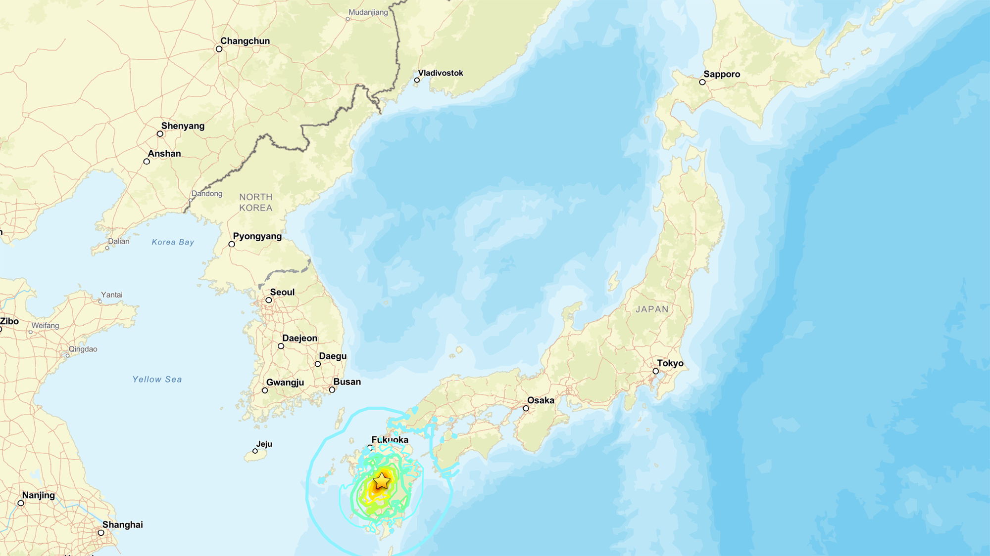
A map showing the location of the July 2026 earthquake. (Image credit: National Tsunami Warning Center (ATWC), Pacific Tsunami Warning Center (PTWC), USGS National Earthquake Information Center, PDE)

The USGS measurement is different from the magnitude 7.1 reported by the Japan Meteorological Agency, "primarily because the agencies are reporting different magnitude types," the USGS reported. While Japan is looking at local magnitude, the USGS measured the moment magnitude, which is derived from the physical size of the fault rupture and gives the "most reliable estimate of earthquake size" for large earthquakes, since local-magnitude scales can lose accuracy once a rupture grows big enough, the USGS reported.

These measurements are helpful, as "different magnitude types capture different characteristics of earthquake source processes," the USGS noted. Local magnitude, for example, reflects how strongly the ground shook nearby, while moment magnitude reflects the total energy released across the fault.

Why this quake is scientifically interesting

Japan sits atop one of the most active plate boundaries on Earth, where the Philippine Sea Plate dives beneath the Eurasia Plate. That process, known as subduction, is responsible for the massive, tsunami-generating earthquakes that periodically strike offshore Japan, and it's been studied intensively for decades.

But Tuesday's earthquake didn't occur at the boundary itself. Instead, the rupture happened within the Eurasia Plate, more than 60 miles (100 kilometers) inland from where the plates meet, Jeffrey Park, a theoretical seismologist at Yale University, told Live Science. Roughly 90% of earthquakes happen at plate boundaries, where the constant grinding of two plates builds up stress until a fault gives way. Quakes that strike farther inside a plate — sometimes called intraplate earthquakes — are rarer and less understood, though scientists suspect that stress transmitted through the plate can reactivate old, dormant faults far from the boundary that produced it.

According to Park, the fault in Tuesday's earthquake moved in a way that suggests the plate tore horizontally as it was twisted by subduction occurring at an angle.

The USGS describes this event as shallow strike-slip faulting: the two sides of the fracture slid past each other horizontally, rather than one side thrusting up and over the other. This faulting style, combined with the shallow depth of just 6 miles (10 kilometers) down, points to the same type of rupture behind Kyushu’s deadly 2016 Kumamoto earthquake sequence.

That inland location is also why the quake didn't generate a damaging tsunami, despite the brief precautionary warning. Tsunamis are produced when a big event ‪—‬ such as an earthquake, volcanic eruption or landslide ‪—‬ displaces water; the force from that displacement then propagates as a wave.

Tuesday's rupture stayed entirely on land, so it never pushed the seafloor up the way offshore quakes do. That's why the tsunami risk stayed low, even with the brief precautionary warning. Still, an inland quake isn't automatically off the hook: if the shaking triggers a landslide that spills into the sea, that alone can generate a tsunami.

The depth mattered just as much as the location. The quake was shallow enough to concentrate its energy near the surface, which Park said explains the structural damage.

"Because it is shallow it will cause more structural damage than a similar-sized event that might occur deeper and offshore," he told Live Science in an email.

Earthquake country

Several earthquakes have already clustered in the area, and numerous aftershocks are expected over the coming days. Japan experiences roughly 1,500 earthquakes annually, making it one of the most seismically active countries on the planet — a byproduct of sitting at the junction of several tectonic plates.

To protect itself, Japan has spent decades — and learned from painful lessons from disasters like the 2011 Tohoku earthquake and tsunami — engineering a response system built for exactly this scenario.

Bullet trains are programmed to halt automatically the instant seismic sensors detect a major earthquake, a safeguard Park pointed to as a defining feature of the country's earthquake readiness. That automatic shutdown extends to other transit and utility systems, part of a broader early-warning network that alerts the public within seconds of a quake's detection, giving people crucial time to take cover before shaking arrives.

Japan's investment in its infrastructure may help to explain why, even after a magnitude 7 event near a city of 700,000, Japan's death toll and damage have historically been far lower than those from comparable quakes elsewhere in the world.

Search-and-rescue efforts are continuing in Kumamoto, with CNN reporting that between 20 and 30 employees remained unaccounted for at the Aeon Mall in Kashima Town, where the building’s second floor had collapsed. Firefighters were also working to reach the site and contain nearby fires.

Colossal scars of 60 million-year-long continental collision streak across warped mountains in Pakistan — Earth from space

28 July 2026 at 11:38
QUICK FACTS

Where is it? Murgha Kibzai, Sulaiman Range, Pakistan [30.739354851, 69.50804296]

What's in the photo? Folded layers of rock left over from an ancient continental collision

Which satellite took the photo? NASA's Terra satellite

When was it taken? April 11, 2011

This striking satellite photo shows a multicolor "fan" of folded rocks sculpted by a longtime collision between two of Earth's tectonic plates.

The geological feature, known as an imbricate fan, is located around 3 miles (5 kilometers) east of the town of Murgha Kibzai in Pakistan's Balochistan province. The photographed section of folded rocks measures around 9 miles (15 km) across, but the fan stretches up to 55 miles (89 km) from end to end, well beyond the area in this image.

The dramatic structure sits at an altitude of around 5,000 feet (1,500 meters) in the Sulaiman Range, a series of mountains that covers around 2,500 square miles (6,500 square kilometers) of Pakistan and Afghanistan. ("Sulaiman" means "of Solomon," in reference to the biblical figure King Solomon, and the range's largest peak is Takht-e-Sulaiman, which translates to "Throne of Solomon.")

This is one of several unique features that emerged along the boundary between the Eurasian and Indian tectonic plates, which have been colliding for more than 60 million years. At one point during this tectonic tug-of-war, the two plates became somewhat intertwined, allowing the fan to take shape, according to NASA's Earth Observatory.

"As India moved northward, it began to rotate in a counter-clockwise direction, wrenching the northwestern part of the Indian plate backwards into part of the Eurasian plate," Earth Observatory representatives wrote. "The countervailing forces put the rocks of the Sulaiman Range in a unique compressional vice, causing many of its faults to curve and stretch in convoluted ways."

A wide-field image of the Sulaiman Range showing massive tectonic features spread out over a large area

The Sulaiman Range is full of unique geological features that were birthed by the collision between the Indian and Eurasian plates. (The imbricate fan is located on the far right of this wide-field image.) (Image credit: NASA/Terra)

The fan is made up of alternating layers of sandstone, which appear dark in the image, and limestone, which has a much lighter hue. These sedimentary rocks were formed by "thrust faults" that shot upward from the boundary between the Eurasian and Indian plates and became entangled as the boundary moved back and forth.

The satellite image is false-color, meaning it includes wavelengths of the electromagnetic spectrum that are not normally visible to humans. This helps to accentuate the differences between the two rock types, although they can also be easily distinguished with the naked eye. Pockets of vegetation appear in red throughout the image.

The photo is a small part of a larger, wide-field image (see above), which showcases several other intriguing geological features across the Sulaiman Range in false color.

Continental collision

The collision between the Eurasian and Indian plates became inevitable around 80 million years ago, when dinosaurs still ruled Earth, according to the Earth Observatory. At this point, the pair became locked on a collision course, with each plate moving more than 8 inches (20 centimeters) per year — around twice the speed of the fastest tectonic plates today.

Around 60 million years ago, the plates slowly slammed together. Normally, this would cause the smallest tectonic plate to sink below the other. However, the two plates' massive size meant neither receded. Instead, the continental crust along the boundary grew thicker, and the ground buckled, folded and pushed upward.

Satellite photo showing the warped shaped of the Sulaiman range

The Indian and Eurasian plates have been locked in a tectonic tug-of-war for more than 60 million years. Their collision birthed the Sulaiman Range, alongside the Karakoram and the Himalayas. (Image credit: Getty Images)

This process created not only the Sulaiman Range but also the Karakoram (a huge mountain range that spans the borders of China, India, Pakistan, Tajikistan and Afghanistan) and the Himalayas — the two tallest mountain ranges on Earth, according to the Earth Observatory.

This collision continued at full speed for around 30 million years, before eventually slowing down. However, the two plates are still technically colliding today, making the region a major earthquake hotspot.

See more Earth from space

A satellite photo showing a black blob of ancient lava surrounding a volcano in the middle of the Sahara desertShadowy tendrils of lava

A 2019 astronaut photo shows off ancient lava flows that once oozed down the jet-black slopes of the Toussidé volcano in northwestern Chad. An intriguing volcanic "skull" also lurks in the aerial image.

An astronaut photo of two near-identical volcanoes standing side-by-side on Indonesia's Java Island.Volcanic 'Twin peaks'

A 2021 astronaut photo shows the surprising similarities between Mount Sundoro and Mount Sumbing, which lie at the heart of Java, Indonesia.

An astronaut photo of the massifConcentric rocky rings

A 2025 astronaut photo shows a massif made of concentric mountain ridges in the Libyan desert. The rocky walls contain ancient artworks and are occasionally used to contain herds of grazing cattle.

Science word of the day: Seamount

28 July 2026 at 09:00

Science word of the day: Seamount

Pronunciation: SEE'-mount

What it means: A seamount is an undersea mountain that rises at least 3,300 feet (1,000 meters) above the seafloor but does not come close to breaking the surface. According to the National Oceanic and Atmospheric Administration, there are at least 100,000 seamounts in the oceans, and less than 0.1% of them have been explored. Seamounts typically form from volcanic activity, and many host dramatic communities of sea life ‪—‬ from coral, to sharks, to an assortment of weird jellyfish-looking things.

How to use it in a sentence: Every time marine biologists explore a seamount with their remotely operated vehicles, they seem to discover a new universe of strange and blobby deep-sea creatures.

Can you crack our science word of the day puzzle, Chain Word?

Science word of the day: Pando

27 July 2026 at 09:00

Science word of the day: Pando

Pronunciation: PAN'-doh

What it means: In Latin, "Pando" means "I spread." And boy, does it. Pando is a clonal stand of aspen trees in Utah that weighs about 13 million pounds (6 million kilograms), making it the world's heaviest living organism ever found. Its 40,000 trees cover 106 acres (43 hectares) in Fishlake National Forest, and they're all connected by a single, sprawling root system. Some DNA analysis suggests that this many-fingered megatree is tens of thousands of years old.

How to use it in a sentence: When you walk through Pando, what seems like a normal stroll through an aspen grove is actually a trip through a single, ancient living being.

Can you crack our science word of the day puzzle, Chain Word?

Science word of the day: Cenozoic

26 July 2026 at 09:00

Science word of the day: Cenozoic

Pronunciation: See-noh-ZOH'-ihk

What it means: The ascendency of mammals, the birth of the Himalayas, the diversification of birds ‪—‬ Earth's in its Cenozoic era, baby!

The Cenozoic is the geological era happening right now. It started 66 million years ago with the abrupt mass extinction known as the Cretaceous-Paleogene extinction event, when a massive asteroid hit Earth and wiped out the nonavian dinosaurs. It's been a busy few tens of millions of years, ushering in such hits as Earth's first cacti, whales and most (if not all) of the Grand Canyon.

How to use it in a sentence: The Cenozoic is called the Age of Mammals, but the University of California Museum of Paleontology in Berkeley would like you to know it could have been called the Age of Teleost Fish, if mammals weren't so dang self-centered.

Can you crack our science word of the day puzzle, Chain Word?

The Last Person on Earth Reinvents Dating Shows

By: Hannah
24 July 2026 at 20:21

The Last Person on Earth will bring a different kind of dating experiment to Apple TV, pairing people who appear fundamentally incompatible before sending them to some of the world most romantic and isolated destinations.

Apple announced the eight-episode documentary series with Esther Perel, the bestselling author, psychotherapist and relationship expert known for examining desire, intimacy, infidelity and the tensions inside modern partnerships.

Perel will work with a team of matchmakers and therapists to create pairings that challenge the usual assumptions surrounding compatibility. Rather than finding contestants who share the same interests, routines and preferences, the series will deliberately bring together people who may initially see each other as the last person they would ever choose.

The central question is whether attraction can develop when familiar dating checklists are removed. Apple describes the series as an exploration of whether an unexpected partner can become the person someone ultimately cannot imagine living without.

No premiere date, contestant list or filming locations have been announced.

Apple TV logo with a glowing apple icon and the letters "tv" on a vibrant gradient background, shifting from orange to purple and blue—reflecting the dynamic spirit of Apple TV competition. The small Apple logo appears in the bottom right corner.
Image Credit: AppleMagazine

The Last Person on Earth Challenges Compatibility

The Last Person on Earth enters a crowded dating television market with a premise that rejects one of the most common promises made by matchmaking services: that compatibility can be predicted through similarity.

Dating apps routinely organize potential relationships through age, location, interests, lifestyle preferences, political beliefs and other personal filters. The process can help users avoid obvious conflicts, but it can also create increasingly narrow definitions of who deserves consideration.

Perel has frequently argued that desire does not always emerge from familiarity. Attraction can depend on difference, curiosity and the discovery of qualities that were not included on a checklist.

The Apple TV series turns that idea into a structured experiment. Participants will meet someone who appears to contradict their expectations before traveling together to a remote setting where ordinary distractions and familiar support systems may be limited.

That environment creates immediate dramatic possibilities. A beautiful destination can make a first connection feel unusually intense, but isolation can also expose differences that would remain hidden during short dates in familiar surroundings.

The presence of therapists and matchmakers suggests that the series will examine those reactions rather than presenting every disagreement as entertainment. Perel can help participants distinguish between genuine incompatibility, defensive habits and discomfort created by encountering someone outside their usual pattern.

The experiment does not promise that every opposite pairing will succeed. Difference can produce curiosity, but it can also reveal conflicts involving values, communication, life goals or emotional availability.

The more revealing outcome may be whether participants leave with a broader understanding of attraction, even when the relationship itself does not continue.

Esther Perel Brings a Different Voice to Dating TV

Perel gives the series a more analytical foundation than the competition-driven structure used by many dating programs.

Her books Mating in Captivity and The State of Affairs examine the contradictions surrounding commitment, desire and personal freedom. She also hosts the podcasts Where Should We Begin? and How Work, presenting conversations that explore relationships without reducing complicated behavior to simple villains and heroes.

That background may help The Last Person on Earth avoid familiar reality television shortcuts. Dating shows often depend on rapid attraction, artificial scarcity and public rejection. Contestants compete for one person, choose partners through brief impressions or make long-term commitments before they have experienced ordinary life together.

The new series begins with a different source of tension. Participants are not being told that a seemingly perfect match has been selected. They are being asked to question why someone who appears wrong may deserve a closer look.

Perel describes the project as an invitation to move beyond what feels familiar or safe. Her involvement also raises expectations that the series will explore how participants construct their preferences.

A person may insist on dating only someone with a certain career, personality or social style without understanding where that requirement originated. Some preferences protect legitimate needs. Others may repeat an old relationship pattern or prevent vulnerability by eliminating anyone capable of creating uncertainty.

The matchmakers and therapists can examine those distinctions before, during and after the trip. Their role could become particularly valuable when participants confuse immediate comfort with long-term suitability or mistake tension for romantic chemistry.

Apple has not explained how long each pairing will remain together, whether several couples will appear in each episode or how the experiment will determine its final outcomes.

The Last Person on Earth - Two illustrated people lean on each other against a purple background with the text "Where Should We Begin? with Esther Perel" above them in bold white letters, evoking the heartfelt connection at the center of Esther Perel’s celebrated series—now featured on Apple TV.
Image Source: Google

Remote Destinations Change the Dating Environment

Sending couples to romantic and remote destinations adds more than scenery.

Modern dating frequently develops through phones, messaging, social media profiles and quick meetings fitted around work schedules. Participants may arrive with established habits for checking other options, retreating into digital distractions or ending contact before uncertainty has time to become meaningful.

A remote journey removes part of that structure. Two people must spend sustained time together, make decisions and respond to unfamiliar situations without immediately returning to separate routines.

Travel can accelerate intimacy because it creates shared memories and reveals behavior under pressure. Delays, unfamiliar environments, fatigue and practical disagreements may show more than a polished restaurant conversation.

The destinations may also create a misleading sense of closeness. A relationship formed in an exceptional setting still needs to survive ordinary responsibilities, geography, work and family expectations after the trip ends.

The documentary format gives Apple an opportunity to follow that transition rather than ending with a dramatic choice at the destination. Whether the series continues documenting the couples after they return home has not been disclosed.

The title adds another layer to the concept. The “last person” can mean the least expected match, but it also reflects the anxiety surrounding modern dating. A growing number of people describe exhaustion with apps, repeated disappointment and the feeling that suitable partners are disappearing.

Apple links the experiment to rising social isolation and polarization. People increasingly sort themselves into cultural, political and lifestyle groups, while digital systems learn to reinforce existing preferences.

A relationship series built around difference can test whether those divisions remain as rigid when two people encounter each other as individuals rather than profiles representing opposing categories.

Unscripted Relationships

The eight-episode order gives the production enough space to develop several pairings without extending the experiment indefinitely. Its success will depend on whether the participants receive room to behave naturally or are pushed toward the exaggerated conflict expected from conventional dating television.

Perel provides the series with a promising tension: lasting relationships require genuine compatibility, yet attraction can disappear when every element feels predictable. The challenge is not proving that opposites always belong together. It is discovering which differences create possibility and which ones should remain deal-breakers.

The post The Last Person on Earth Reinvents Dating Shows appeared first on AppleMagazine.

NASA’s ESCAPADE Snaps Family Portrait of Earth, Moon

24 July 2026 at 18:47

On July 3, one of NASA’s two Mars-destined ESCAPADE (Escape and Plasma Acceleration and Dynamics Explorers) spacecraft captured photos of Earth and the Moon in visible and thermal infrared light. At the time, the spacecraft was 363,250 miles (584,600 kilometers) from Earth and 115,600 miles (186,100 kilometers) from the Moon, making the Moon appear relatively large.

Taken with the Sun only partly illuminating Earth and the Moon, the visible light image shows the two bodies as crescents, with only around 8% of each face sunlit. Yet in the thermal infrared image, the shadowed hemisphere of Earth is illuminated by its own heat from both the atmosphere and surface, glowing at minus 10 to minus 44 degrees Fahrenheit (250 to 280 kelvins). Without the insulating blankets of oceans and atmospheres, the Moon’s far side remains at a much cooler minus 280 degrees Fahrenheit (100 kelvins).

visible light
thermal infrared light
A black background with a thin white crescent on the left representing the Earth, and a thin off-white crescent on the right represents the Moon.
Caption: In these images from NASA’s ESCAPADE mission, Earth (left) and Moon (right) can be seen. The image to the left of the slider shows visible light reflected by the Sun while the infrared image to the right shows the bodies’ emitted energy. White rings have been added in the thermal image to show the actual size of Earth and the Moon. Credit: NASA/UCB-SSL/NAU-Radiant/Lucint
NASA/UCB-SSL/NAU-Radiant/Lucint
On a pitch black background sits a bright circle on the left filled with yellow, orange, and red and surrounded by a faint halo of purple. On the right, is a circle outlined with a white line, filled with black and a thin purple crescent on the right side of the circle.
In these images from NASA’s ESCAPADE mission, Earth (left) and Moon (right) can be seen. The image to the left of the slider shows visible light reflected by the Sun while the infrared image to the right shows the bodies’ emitted energy. White rings have been added in the thermal image to show the actual size of Earth and the Moon.
NASA/UCB-SSL/NAU-Radiant/Lucint
visible light
thermal infrared light

ESCAPADE Photos of Earth and Moon

July 3, 2026

In these images from NASA’s ESCAPADE mission, Earth (left) and Moon (right) can be seen. The image to the left of the slider shows visible light reflected by the Sun while the infrared image to the right shows the bodies’ emitted energy. White rings have been added in the thermal image to show the actual size of Earth and the Moon. Credit: NASA/UCB-SSL/NAU-Radiant/Lucint

The ESCAPADE mission used its Visible and Infrared Observation System cameras, provided by Northern Arizona University in Flagstaff, to capture the images, which are more than just road trip photo album snaps.

“We are thrilled that ESCAPADE was able to accommodate these excellent space-qualified cameras which will search for visible Martian aurora and investigate thermal properties of the Martian surface and atmosphere,” said Rob Lillis, the mission’s principal investigator at the University of California, Berkeley. “Since Earth and the Moon are well-known targets, imaging them provides an important calibration check for ESCAPADE’s cameras.”

The ESCAPADE spacecraft, which were built by Rocket Lab, are currently in a “loiter” orbit around Lagrange point 2, a location in space about a million miles from Earth. In November 2026, the spacecraft will fly by Earth to use the planet’s gravity to slingshot their way to Mars. When the spacecraft arrive in September 2027, they will study how a million-mile-per-hour stream of material flowing from the Sun, known as solar wind, interacts with the Martian environment and how that drives atmospheric loss at the Red Planet.

The ESCAPADE mission is funded by NASA’s Heliophysics Division and is part of the NASA Small Innovative Missions for Planetary Exploration program. The UC Berkeley’s Space Sciences Laboratory leads the mission with key partners Rocket Lab; NASA’s Goddard Space Flight Center in Greenbelt, Maryland; Embry-Riddle Aeronautical University; Advanced Space; and Blue Origin.

By Mara Johnson-Groh
NASA’s Goddard Space Flight Center, Greenbelt, Md.

The post NASA’s ESCAPADE Snaps Family Portrait of Earth, Moon appeared first on NASA Science.

NASA’s ESCAPADE Snaps Family Portrait of Earth, Moon

24 July 2026 at 18:47

On July 3, one of NASA’s two Mars-destined ESCAPADE (Escape and Plasma Acceleration and Dynamics Explorers) spacecraft captured photos of Earth and the Moon in visible and thermal infrared light. At the time, the spacecraft was 363,250 miles (584,600 kilometers) from Earth and 115,600 miles (186,100 kilometers) from the Moon, making the Moon appear relatively large.

Taken with the Sun only partly illuminating Earth and the Moon, the visible light image shows the two bodies as crescents, with only around 8% of each face sunlit. Yet in the thermal infrared image, the shadowed hemisphere of Earth is illuminated by its own heat from both the atmosphere and surface, glowing at minus 10 to minus 44 degrees Fahrenheit (250 to 280 kelvins). Without the insulating blankets of oceans and atmospheres, the Moon’s far side remains at a much cooler minus 280 degrees Fahrenheit (100 kelvins).


visible light
thermal infrared light

A black background with a thin white crescent on the left representing the Earth, and a thin off-white crescent on the right represents the Moon.
Caption: In these images from NASA’s ESCAPADE mission, Earth (left) and Moon (right) can be seen. The image to the left of the slider shows visible light reflected by the Sun while the infrared image to the right shows the bodies’ emitted energy. White rings have been added in the thermal image to show the actual size of Earth and the Moon. Credit: NASA/UCB-SSL/NAU-Radiant/Lucint
NASA/UCB-SSL/NAU-Radiant/Lucint

On a pitch black background sits a bright circle on the left filled with yellow, orange, and red and surrounded by a faint halo of purple. On the right, is a circle outlined with a white line, filled with black and a thin purple crescent on the right side of the circle.
In these images from NASA’s ESCAPADE mission, Earth (left) and Moon (right) can be seen. The image to the left of the slider shows visible light reflected by the Sun while the infrared image to the right shows the bodies’ emitted energy. White rings have been added in the thermal image to show the actual size of Earth and the Moon.
NASA/UCB-SSL/NAU-Radiant/Lucint

A black background with a thin white crescent on the left representing the Earth, and a thin off-white crescent on the right represents the Moon.
Caption: In these images from NASA’s ESCAPADE mission, Earth (left) and Moon (right) can be seen. The image to the left of the slider shows visible light reflected by the Sun while the infrared image to the right shows the bodies’ emitted energy. White rings have been added in the thermal image to show the actual size of Earth and the Moon. Credit: NASA/UCB-SSL/NAU-Radiant/Lucint
NASA/UCB-SSL/NAU-Radiant/Lucint
On a pitch black background sits a bright circle on the left filled with yellow, orange, and red and surrounded by a faint halo of purple. On the right, is a circle outlined with a white line, filled with black and a thin purple crescent on the right side of the circle.
In these images from NASA’s ESCAPADE mission, Earth (left) and Moon (right) can be seen. The image to the left of the slider shows visible light reflected by the Sun while the infrared image to the right shows the bodies’ emitted energy. White rings have been added in the thermal image to show the actual size of Earth and the Moon.
NASA/UCB-SSL/NAU-Radiant/Lucint

visible light

thermal infrared light

ESCAPADE Photos of Earth and Moon

July 3, 2026


In these images from NASA’s ESCAPADE mission, Earth (left) and Moon (right) can be seen. The image to the left of the slider shows visible light reflected by the Sun while the infrared image to the right shows the bodies’ emitted energy. White rings have been added in the thermal image to show the actual size of Earth and the Moon. Credit: NASA/UCB-SSL/NAU-Radiant/Lucint

The ESCAPADE mission used its Visible and Infrared Observation System cameras, provided by Northern Arizona University in Flagstaff, to capture the images, which are more than just road trip photo album snaps.

“We are thrilled that ESCAPADE was able to accommodate these excellent space-qualified cameras which will search for visible Martian aurora and investigate thermal properties of the Martian surface and atmosphere,” said Rob Lillis, the mission’s principal investigator at the University of California, Berkeley. “Since Earth and the Moon are well-known targets, imaging them provides an important calibration check for ESCAPADE’s cameras.”

The ESCAPADE spacecraft, which were built by Rocket Lab, are currently in a “loiter” orbit around Lagrange point 2, a location in space about a million miles from Earth. In November 2026, the spacecraft will fly by Earth to use the planet’s gravity to slingshot their way to Mars. When the spacecraft arrive in September 2027, they will study how a million-mile-per-hour stream of material flowing from the Sun, known as solar wind, interacts with the Martian environment and how that drives atmospheric loss at the Red Planet.

The ESCAPADE mission is funded by NASA’s Heliophysics Division and is part of the NASA Small Innovative Missions for Planetary Exploration program. The UC Berkeley’s Space Sciences Laboratory leads the mission with key partners Rocket Lab; NASA’s Goddard Space Flight Center in Greenbelt, Maryland; Embry-Riddle Aeronautical University; Advanced Space; and Blue Origin.

By Mara Johnson-Groh
NASA’s Goddard Space Flight Center, Greenbelt, Md.

Noble Gases Along for the Ride

24 July 2026 at 17:00

A rendering of an orange and grey planet against a dark background.

What can some neon trapped in a chunk of rock tell us about Earth’s formation and the protosolar nebula? Quite a lot, as detailed in a recent study in The Planetary Science Journal.

Noble Mysteries

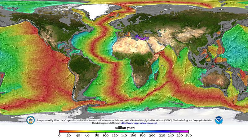
By analyzing rocks pulled from mid-ocean ridges, geologists have concluded that there are tiny amounts of noble gases in the deep interior of Earth. That’s a strange statement upon reflection: how did these gases, which are famously apathetic to essentially all other elements, end up embedded within rocks thousands of kilometers underground? Since their passivity rules out the potential of a chemical reaction that formed them in place, they must have been in the mantle since the very beginning of Earth’s history.

A map of Earth with the continents shown normally but the sea colored according to age.

A map illustrating the age of the seafloor. Mid-ocean ridges stand out clearly in red. By sampling material from these ridges, planetary scientists can infer the composition of Earth’s deep interior. Click to enlarge. [Mr. Elliot Lim, CIRES and NOAA/NCEI]

There are a few scenarios for how this could have happened. Though it’s possible that these inert species were delivered to the early Earth encapsulated within primitive meteorites or in solids contaminated by ions from the solar wind, at least some fraction of these elements likely came directly from the gaseous nebula that surrounded the earliest protoplanets.

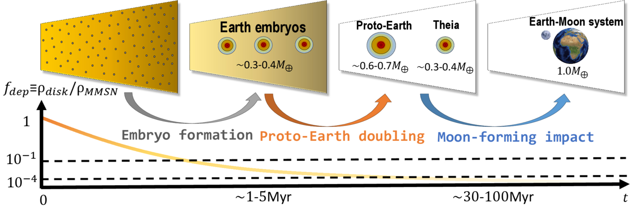
That last option is especially exciting to present-day planetary scientists interested in constraining Earth’s formation history because it requires some very specific conditions. Since light noble gases like neon don’t dissolve well in seawater, they must have dissolved into a magma ocean — meaning the nebula was still around when Earth was large enough to have a molten surface. That already restricts us to a very specific time in the solar system’s history, but it doesn’t say much about the specific size of the proto-Earth other than “big,” and it doesn’t say much about the state of the nebula other than “it existed.” Recently, Vincent Savignac and Eve Lee (University of California, San Diego; McGill University) successfully refined these constraints to pin down information about both the early Earth and the nebula that surrounded it.

Infant Earths

Savignac and Lee began by growing a grid of infant Earths on their computers via models of gas accretion and atmosphere–magma interactions. Each simulation started with a different proto-Earth mass and nebular density, and each one yielded a different amount of neon in Earth’s deep interior. Excitingly, only a small handful of the scenarios tested ended up with values similar to those observed.

A cartoon of small cores surrounded by gaseous envelopes eventually merging into the Earth.

A schematic of Earth’s formation via embryo formation (when the noble gases enter the mantle) followed by mergers. Click to enlarge. [Savignac & Lee 2026]

On the mass axis, the team found a narrow range of acceptable conditions. If a proto-Earth was less than about 20% of Earth’s present-day mass, it couldn’t accrete much gas. This let it cool rapidly, freezing the magma ocean and shutting down neon dissolution before too much could be trapped inside. On the other hand, if a proto-Earth was more than about 40% of Earth’s present-day mass, it would accrete too much gas, stay molten for too long, and be left with too much neon. On the density axis, the researchers found that when the nebula accreted on to the proto-Earth, it must have been fairly depleted compared to its initial density. This implies that the whole process happened at the end of the nebula’s life, just before it was completely blown away by the proto-Sun.

Savignac and Lee demonstrated that these constraints are robust against the later stages of Earth’s evolution. In its later years, Earth either suffered or benefited from a giant impact, depending on your feelings about the Moon, but the researchers showed that this event doesn’t pose a problem for their models. Overall, this study builds a delightful link between rocks from our deep oceans and the particulars of Earth’s formation, demonstrating the unique power of planetary science to tie together different scientific fields.

Citation

“Constructing the Earth’s Formation History Using Deep Mantle Noble Gas Reservoirs,” Vincent Savignac and Eve J. Lee 2026 Planet Sci. J. 7 135. doi:10.3847/PSJ/ae64f7

The post Noble Gases Along for the Ride appeared first on AAS Nova.

The Hotspot Beneath Hawaii Is Getting Hotter, Defying a Long-Held Geological Theory

Lava Fountaining at Halema’uma’u Crater at the Summit of Kīlauea VolcanoRising mantle temperatures and two heat surges may explain why some Hawaiian volcanoes grew exceptionally large. A 3500 km (2200 mile) trail of volcanoes records the Pacific plate’s slow passage over the Hawaiian hotspot. Instead of cooling through time as geologists have generally expected, the mantle plume beneath this chain appears to have warmed by [...]

Scientists Warn a Silent Oxygen Crisis Is Spreading Through Earth’s Waters

Deep Water Abyss Underwater SunlightNew research calls for aquatic deoxygenation to be recognized as a critical planetary process under threat. Oxygen is declining across oceans, coastal waters, rivers, lakes and streams, threatening the organisms and chemical processes that depend on it. A review led by researchers at UC San Diego’s Scripps Institution of Oceanography warns that this widespread deoxygenation [...]

Apple TV announces new dating series ‘The Last Person on Earth’

23 July 2026 at 16:32
Apple TV announced a new dating documentary series, “The Last Person on Earth,” with relationship expert Esther Perel.

Apple TV on Thursday announced a new eight-episode dating documentary series, “The Last Person on Earth,” with New York Times bestselling author and renowned couples therapist Esther Perel. In the series, couples who appear to be opposites are expertly paired by Perel and a team of matchmakers and therapists, before embarking on an adventure in one of the world’s most romantic and remote destinations. With more single people than ever before and increasing levels of polarization and social isolation, this innovative experiment asks the question: could the last person on Earth you think you’d ever want to date end up being the one person you can’t live without? And will an unexpected pairing in paradise open their horizons and be the beginning of a life-changing relationship?

“Over the course of my career as a couples therapist, one truth has become undeniable: love may crave closeness, but desire is fueled by otherness,” said Perel in a statement. “‘The Last Person on Earth’ is a bold exploration of relationships that challenges everything we assume about compatibility; inviting people to drop the checklist and embrace dating as an adventure into the unknown. When we choose to step outside the narrow boundaries of what feels familiar or safe, passionate love stories can flourish.”
From Boldprint Studios, “The Last Person on Earth” is executive produced by Dan Gray, Lou Hutchinson and Phil Harris, with series director Josh Jacobs. Olly Lambert also serves as director on the series.

Apple TV offers premium, compelling drama and comedy series, feature films, groundbreaking documentaries, and kids and family entertainment, and is available to watch across all of a user’s favorite screens. After its launch on November 1, 2019, Apple TV became the first all-original streaming service to launch around the world, and has premiered more original hits and received more award recognitions faster than any other streaming service in its debut. To date, Apple Original films, documentaries and series have been honored with 850 wins and 3,800 award nominations and counting including multi-Emmy Award-winning and history-making comedies “The Studio” and “Ted Lasso,” global cultural phenomenon “Severance,” Apple’s most-viewed drama “Pluribus,” Academy Award Best Picture winner “CODA” and Academy Award winner “F1,” the highest-grossing sports feature of all time.

MacDailyNews Note: Apple TV is available on the Apple TV app in over 100 countries and regions, on over 1 billion screens, including iPhone, iPad, Apple TV 4K, Apple Vision Pro, Mac, popular smart TVs from Samsung, LG, Sony, VIZIO, TCL and others, Roku and Amazon Fire TV devices, Chromecast with Google TV, PlayStation and Xbox gaming consoles, and at tv.apple.com, for $12.99 per month with a seven-day free trial for new subscribers. For a limited time, customers who purchase and activate a new iPhone, iPad, Apple TV 4K or Mac can enjoy three months of Apple TV for free.

Watch on Apple TV


‎
Please help support MacDailyNews — and enjoy subscriber-only articles, comments, chat, and more — by subscribing to our Substack: macdailynews.substack.com. Thank you!

Support MacDailyNews at no extra cost to you by using this link to shop at Amazon.

The post Apple TV announces new dating series ‘The Last Person on Earth’ appeared first on MacDailyNews.

Satellite spots a 'hummingbird' in Antarctica | Space photo of the day for July 23, 2026

23 July 2026 at 15:00

A black and white hummingbird shape appears in data of a mountaintop.

A hummingbird shape in satellite data from NISAR is actually a mountaintop spotted in Antarctica. (Image credit: NASA/JPL-Caltech)

In satellite data captured over Antarctica, what appears to be a beautiful, colorful hummingbird emerges from the crest of a mountaintop.

What is it?

While there are no hummingbirds flying around Antarctica, we can see what looks like a small, purple bird in a new satellite image of an Antarctic mountain. The dark belly of this "bird" at the center of this image is actually the top of the mountain Nunatak Zaterjavshijsja in East Antarctica.

What looks like a bird's tail is a stream of ice flowing northeast all the way out to the ocean, and what appear to be feathers splaying outward from the mountaintop are actually crevasses down the mountain. These crevasses are formed by a glacier fracturing the mountain's surface as it flows in the icy current toward the ocean.

This view was captured by radar instruments onboard the satellite NISAR (NASA-ISRO Synthetic Aperture Radar) that launched as a collaboration between NASA and ISRO (Indian Space Research Organisation). The director of NASA's Earth Science Division called NISAR "the most sophisticated radar we've ever built" in a pre-launch briefing last year.

Why is it incredible?

At first glance, this image is puzzling. What could it possibly be? Its bold colors and sharp lines evoke almost alien qualities. But the strange beauty of the shapes and colors in this satellite image reveal important information about glacier movements on the mountain.

"First, it's a beautiful image, with rich details of features that provide insights to how the glacier is moving. Then, because radar can often see through snow and deep into the ice, NISAR can observe fundamentally different properties of Antarctic ice than can be seen in optical imagery," Seongsu Jeong, the signal analysis engineer who produced the image at NASA's Jet Propulsion Laboratory, said in a statement. "With NISAR we're seeing what's hidden beneath the surface."

And now anyone can explore NISAR's data. Earlier this week, on July 20, NISAR started making the data from its radar instruments public. Moving forward, mission teams will be rolling out this data so researchers everywhere can use it to study and protect our ever-changing planet.

Science word of the day: Abiotic

23 July 2026 at 09:00

Science word of the day: Abiotic

Pronunciation: Ay-bye-AH'-tik

What it means: Abiotic means "without living organisms." Scientists typically use the term when referring to nonliving aspects of an ecosystem that affect organisms' growth or reproduction. Some abiotic factors might be light, water, fertilizer, nutrients or chemical elements, such as oxygen or sulfur. Others include the tides or rain. Sometimes, "abiotic" is used to describe the origin of a particular chemical. Abiotic methane, for example, comes from chemical reactions between rocks and water in Earth's crust, unlike biotic methane, which comes from decaying organic matter as well as microbes living in your gut.

How to use it in a sentence: A new "gold rush" of exploration is on for abiotic hydrogen, which forms when rocks react with water deep underground and could be a renewable, carbon-free fuel of the future.

Can you crack our science word of the day puzzle, Chain Word?

Science word of the day: Abiogenesis

22 July 2026 at 09:00

Science word of the day: Abiogenesis

Pronunciation: Ay-bye-oh-JEN'-ih-sis

What it means: Abiogenesis is the emergence of life from nonliving matter through chemical processes. Scientists still don't know exactly how abiogenesis happened on Earth. Theories range from lightning strikes that could have scrambled water, methane, ammonia and hydrogen into amino acids and sugars ‪—‬ the building blocks of life ‪—‬ to chemical reactions at deep-sea vents. Abiogenesis is not the same as spontaneous generation, which held that living organisms such as maggots formed directly from decaying matter. It was a compelling idea for anyone who had watched meat rot, but Louis Pasteur, inventor of pasteurization, disproved it in the 1860s by showing that microbes could only grow from preexisting microbes.

How to use it in a sentence: All life on Earth may owe itself to an incident of abiogenesis more than 3.7 billion years ago.

Can you crack our science word of the day puzzle, Chain Word?

Greenland meltwater will drive a 'strong weakening, but not a shutdown' of key Atlantic currents, study finds

Runoff from Greenland's rapidly melting ice sheet could severely disrupt currents in the Atlantic Ocean that regulate the global climate, researchers say. But the fresh water won't trigger the complete and irreversible collapse of the circulation that some research predicts, a new study suggests.

By 2100, Greenland meltwater could cause a reduction in the strength of the Atlantic Meridional Overturning Circulation (AMOC) equivalent to an additional 10% to 20% on top of the weakening that many scientists already expect for this huge system of currents, researchers found.

Previous research suggests the AMOC, which moves heat from the tropics to the Northern Hemisphere and cold water back south toward Antarctica, is at its weakest in more than 1,000 years due to Arctic ice melt and soaring ocean temperatures. Models indicate that the circulation will continue to weaken for decades to come, potentially unleashing freezing weather in Northwest Europe, additional sea-level rise along the U.S. East Coast and droughts around the equator.

Animation showing surface and bottom currents across the world's oceans.

The AMOC loops around the Atlantic Ocean, bringing warm waters north along the ocean's surface and cold waters south along the ocean floor. (Image credit: NASA/Goddard Space Flight Center Scientific Visualization Studio)

The new study revealed that by 2300, Greenland's ice sheet could cause a whopping 40% of AMOC weakening on top of the declines projected by some climate models if we continue to cook the planet. The results highlight the effects on the AMOC of a growing freshwater pulse from Greenland that most climate models currently don't take into account, the authors said.

"By the year 2100, yes, we have something, but the greatest fraction is what we add later," study co-author Jost von Hardenberg, a professor in the Department of Environment, Land and Infrastructure Engineering at the Polytechnic University of Turin in Italy, told Live Science.

Meltwater from the Arctic and Greenland slows the AMOC by preventing the formation of deep currents in the North Atlantic that drive the circulation south toward Antarctica. Deep currents form when masses of cold, salty water sink to the seabed, but inputs of fresh water and rising water temperatures are blocking this step by diluting and warming surface waters.

While Arctic meltwater is commonly integrated into climate simulations, researchers have been slower to include runoff from the Greenland ice sheet in models, partly because this runoff may not be as disruptive as Arctic meltwater on shorter timescales, von Hardenberg said.

"In order to represent correctly the Greenland melt, you need a specific, dynamic model for the Greenland ice sheet. It's nice to have, but it requires a lot of resources to develop," von Hardenberg said

The Community Ice Sheet Model version 2 (CESM2) is one of the few available simulations of the Greenland ice sheet. For the study, von Hardenberg and his colleagues used a global climate model called EC-Earth3, which does not include the Greenland ice sheet. The team added the ice sheet from CESM2 to explore how it might affect the AMOC over the next few centuries. Adding the ice sheet separately enabled them to compare AMOC weakening with and without Greenland, clearly revealing the impact of the ice sheet on the AMOC's strength.

The results, published June 19 in the journal Science Advances, suggest the Greenland ice sheet will have a big influence on Atlantic ocean currents, especially after 2100.

"Greenland starts really melting strongly only after that date," von Hardenberg said. "If you go farther in our simulation — we go up to the year 2300 — that is also when this meltwater really becomes extremely strong."

Yet unlike other studies that show the AMOC collapsing irreversibly under climate change, in this model, the circulation recovered once the team switched off the meltwater or dialed down greenhouse gas emissions. Both the simulations that didn't include the Greenland ice sheet and those that did had similar results, recovering partially when the meltwater was turned off and fully when greenhouse gas emissions were stopped.

The recovery in the model suggests that the AMOC is more stable than previously thought and doesn't suddenly flip from an active state into a collapsed one, von Hardenberg said. "It's consistent with a strong weakening, but not a shutdown," he said.

Overall, the findings show that it is important to include the Greenland ice sheet in climate models — something von Hardenberg and his colleagues are planning to do in the next version of the EC-Earth3 model.

"It's really something which is worthwhile doing to better constrain the uncertainty of these future simulations," von Hardenberg said. "If we have a larger set of models which include this component, we will be in a better position to try to answer the question, 'How much do we expect AMOC to decrease in different scenarios?'"

Other experts agreed that integrating the Greenland ice sheet in climate models will increase the accuracy of AMOC predictions.

"What makes the study particularly interesting is that it directly tests a process that has often been highlighted as an important source of uncertainty in future AMOC projections," said Jonathan Baker, a senior climate scientist at the Met Office in the U.K. who was not involved in the study.

The results are consistent with previous research showing that Greenland meltwater causes additional AMOC weakening, but whether the system could collapse is still uncertain, given that the team used only one model, Baker told Live Science in an email. "Repeating these experiments across a wider range of models will be important to assess how robust the findings are," he said.

Nicholas Foukal, an assistant professor at the University of Georgia's Skidaway Institute of Oceanography who was not involved in the study, said he doesn't think the use of a single model limits the analysis.

"I think this result is robust and I am glad to see the authors come to this conclusion in such a high-resolution and realistic coupled climate model," Foukal told Live Science in an email. "This finding also agrees with other modeling results that require immense amounts of fresh water, much more fresh water than is available on Greenland, to cause irreversible change in the AMOC."

However, a third expert said the model used in the study is unrealistic, because its parameters make the AMOC more resilient than those of other models. Therefore, the study should be replicated in other models to draw unbiased conclusions.

"While the experiment reported is interesting, its outcomes are neither surprising nor should be interpreted as exemplary for the whole model ensemble," Sybren Drijfhout, a professor of physical oceanography at the University of Southampton in the U.K., told Live Science in an email.

Researchers should investigate the impact of the Greenland ice sheet on the AMOC further, von Hardenberg said. "It would be interesting in the future to check it [the AMOC's recovery with Greenland meltwater] with other models, but of course it's encouraging to see it in one case," he added.

Scientists Warn Something is Vanishing from Earth’s Oceans at an Alarming Rate, Driving the Planet Into an “Unsafe Space”

21 July 2026 at 16:58

Scientists are sounding the alarm over a worsening situation in Earth’s oceans and freshwater systems, according to a new study that warns of “irreversible” changes our planet could be facing.

New research led by the Scripps Institution of Oceanography at UC San Diego has revealed the rapid disappearance of oxygen from bodies of sea and fresh water, leading to environmental changes that could endure for centuries if left unmitigated.

The new study, which appeared in the journal Limnology and Oceanography, argues that widespread aquatic deoxygenation—reduced levels of dissolved oxygen in oceans and coastal waters, lakes, rivers, and streams—is increasingly becoming a problem, and one that influences nine other crucial environmental processes.

These processes are all included in what is known as the Planetary Boundaries framework, a science-based tool that outlines the requirements of a safe operating space for humanity. Introduced in 2009 by Earth system scientists led by Johan Rockström, this framework identifies nine critical environmental processes that regulate Earth’s stability.

Specifically, the nine planetary boundaries outlined in this framework are climate change, biosphere integrity, land use changes, biogeochemical flow of nutrients, ocean acidification, freshwater changes, atmospheric aerosol loading, stratospheric ozone depletion, and pollution.

Now, the Scripps researchers behind the recent study say they believe dissolved oxygen levels should also be formally included in this framework.

Aquatic Deoxygenation is a Growing Concern

Erica Ferrer, a Scripps Oceanography alumna and current postdoctoral scholar at UC Santa Barbara’s National Center for Ecological Analysis and Synthesis and lead author of the new study, says that her team’s work “is designed to elevate the profile of aquatic deoxygenation as a global threat and show that it does not operate in isolation.”

“The health and stability of our planet depends on the health and stability of aquatic ecosystems, which need oxygen to function normally,” Ferrer said.

Driving this growing problem, the new research says, is the excessive influx of nutrient pollution into water bodies, as well as anthropogenic warming, and changes occurring in natural ventilation systems within deep ocean waters.

With depleting oxygen levels scientists are seeing, longer-term changes to chemical and biological processes that regulate our planet’s climate are expected to occur. The decline, Ferrer and her colleagues argue, is also likely to impact a diverse range of aquatic organisms and ecosystems.

Even ocean mammals that acquire air at the surface are likely to be impacted, since deoxygenation can either cause the relocation or outright depletion of the organisms that make up their diets. This, in addition to causing severe damage to habitats and alterations to the food webs they depend on.

Ferrer and her colleague, study co-author and Scripps biological oceanographer Lisa Levin, are hopeful that their findings will encourage a deeper level of engagement on the potential ramifications of aquatic oxygen loss, and how other environmental challenges outlined in the planetary boundaries framework can act as multipliers, rather than separate existential concerns.

“Adding aquatic deoxygenation to the Planetary Boundaries framework will help us understand its impacts on Earth system stability,” Ferrer said in a statement, adding that mitigation of ocean deoxygenation impacts “represents a critical component of maintaining biodiversity and climate.”

Levin, Ferrer, and their colleagues’ study, “Abundant interactions and feedbacks between aquatic deoxygenation and the other planetary boundaries suggest ‘unsafe’ levels of oxygen loss with far‐reaching impacts,” appeared in the journal Limnology and Oceanography on June 30, 2026.

Micah Hanks is the Editor-in-Chief and Co-Founder of The Debrief. A longtime reporter on science, defense, and technology with a focus on space and astronomy, he can be reached at micah@thedebrief.org. Follow him on X @MicahHanks, and at micahhanks.com.

A massive crater was spotted on Google Earth. It could be a scar from an ancient meteorite impact

21 July 2026 at 13:00

An amateur astronomer's plans for a camping vacation two years ago transformed into a possible crater find in Canada's north.

Amateur astronomer Joël Lapointe, using Google Maps to figure out his route for the 2024 vacation, saw some odd terrain in Quebec's Côte-Nord region centered on Lake Marsal. Lapointe suspected it was an impact crater from a meteorite, and made a report on Impact Earth — a crowdsourcing website for craters with Canada's Western University in London, Ontario near Toronto. Western planetary geologist Gordon Osinski made a visit to the region in 2025, provisionally not only confirming the crater, but saying it's probably one of the biggest discovered in recent years. The 390-million-year old feature is roughly 15 miles (25 kilometers) wide.

In an email interview with Space.com while on travel in Scotland, Osinski — known as "Oz" by the space community — said to his knowledge the last discovery of that scale was the approximately 31-km (19-mile) Hiawatha structure, also possibly a crater, spotted in Greenland in 2018. "However, that structure is completely buried by ice, so its diameter is uncertain and there is still some controversy about its origin," Oz said.

But in the case of the new crater, called Uhackatik with approval from the Innu Council of Ekuanitshit in whose traditional lands the crater lies, there is no doubt at all where the crater came from. Oz's expedition to the area revealed "shock metamorphic effects", which are deformations to the rocks induced by the shock waves and heating produced by a meteorite impact.

"Impact melt rocks are like they sound: large volumes of rock that are melted by the impact event, but then cool and crystallize to look a lot like volcanic rocks," he said. "Finding these preserved — as they are usually some of the first parts of a crater to be eroded — was a big surprise."

While most of the features are microscopic, Oz said in the field he and his collaborators could easily see "shatter cones", which are branching features in rock layers produced by the shockwave of impact. The research is not yet peer-reviewed, but it will be presented at the 88th Annual Meeting of the Meteoritical Society in Frankfurt, Germany in August.

two photos of rocks with cone-like striations on them

A shatter cone seen in rocks found at the center of the structure (left); melt rock found 2.5 miles (4 kilometers) west of the structure's center. (Image credit: Gattacceca, J. et al.)

While 400-million-year-old impact craters on Earth are hard to find, as geologic activity as well as erosion change their features over time, the precious evidence is helpful for scientists to better understand meteorite impacts on the moon, Mars and other rocky extraterrestrial bodies.

In terms of age, Oz noted, the moon's prominent Tycho crater best represents what Uhackatik probably looked like 390 million years ago. But On Earth, one of the best comparisons to Uhackatik is a moon-like crater used to help the Artemis II astronauts get ready for their moon mission this year.

That Earth crater is called Kamestastin (also known as Mistastin) in northern Labrador, Canada. Oz regularly runs expeditions there in consultation with the Mushuau Innu First Nation, as the crater lies within their traditional hunting grounds. Kamestastin includes anorthosite, a common mineral found in craters at the moon's south pole, where NASA hopes to land astronauts under the US-led Artemis program.

Artemis II astronauts Jeremy Hansen (from the Canadian Space Agency or CSA) and Christina Koch (NASA), as well as CSA backup astronaut and lunar-flyby capcom Jenni Gibbons, did an expedition to Kamestastin crater in 2023 alongside Oz and collaborators.

"For comparative craters [to Uhackatik], Kamestastin is actually a great one as the size is very similar," Oz said. "Kamestastin is well-preserved and I've worked there a lot … so in my mind, I was using Kamestastin as a template for exploring this new potential crater."

To fully confirm Uhackatik's extraterrestrial origin, Oz and collaborators are examining samples microscopically for more evidence of shock effects, such as chemistry indicating a high-temperature melt, or deformation effects in the quartz. In the meantime, Oz's lunar work with NASA continues: he will be part of the geology teams supporting the moon-landing astronauts during the Artemis 4 and 5 missions, which will touch down as soon as 2028.

Giant, milky-green vortex swirls across massive 'cryptodepression' lake in Southern Europe — Earth from space

21 July 2026 at 08:00
QUICK FACTS

Where is it? Lake Skadar, Montenegro and Albania [42.201087364, 19.303135741]

What's in the photo? A giant, milky-green swirl on the lake's surface

Who took the photo? An unnamed astronaut on board the International Space Station

When was it taken? Feb. 21, 2020

This eye-catching astronaut photo shows a cloud of sediment swirling into a giant, milky-green vortex in one of Europe's largest lakes.

Lake Skadar (also known as Shkodër, Shkodra or Scutari) is the largest lake in Southern Europe, with a surface area between 140 and 200 square miles (360 to 520 square kilometers), depending on the time of year. It is situated on the border between Montenegro, which surrounds the western half of the lake (left in the photo), and Albania, which encircles the lake's eastern shore. The body of water is split 65% to 35% in Montenegro's favor.

The lake's main water source is the Morača River, to the northwest, and its biggest outlets are the Bojana and Drin rivers, which start at the lake's easternmost point and eventually drain into the Adriatic Sea, which is partially visible in the bottom left of the photo. Skadar's southern shore is also hugged by a lofty mountain range, known as the Dinaric Alps.

During late winter and early spring, the lake's water level rises, and it usually fills with a milky-green substance that often gets whipped into a vortex by a combination of wind-driven surface currents and the natural flow of water between the lake's major inlets and outlets.

The swirling material looks very similar to blooming algae, but it is actually made of sediments — predominantly limestone and dolomite — that wash into the lake from the Dinaric Alps and other nearby mountains as the snow melts.

An aerial view of Lake Skadar with the Adriatic Sea in the background

Lake Skadar formed millions of years ago and was once connected to the Adriatic Sea (visible in the background of this image). (Image credit: Wikimedia)

Skadar is a karst lake, meaning it was once a cave system that flooded and eventually collapsed, likely because the caves were made from the same easily erodible rocks that now swirl on the lake's surface, according to NASA's Earth Observatory. The lake is a "cryptodepression" because most of the lake's floor is below sea level.

The lake originally formed during the Cenozoic Era (66 million years ago to the present), according to the International Lake Environment Committee Foundation's World Lake Database. It is home to several small islands, some of which can be seen in the photo along the lake's southern shore. These include Beška, which is home to a pair of 600-year-old churches, and Grmožur, where the remains of a 19th-century fortification loom above the lake's surface.

The shipwreck of a paddle steamboat, named Skanderbeg, lies along the lake's western shore. Local partisans sank the vessel in 1942 after Italian soldiers commandeered it during the Axis occupation of Yugoslavia in World War II. When the lake's water levels are at their lowest, part of the shipwreck rises above the surface.

Skadar Lake is a biodiversity hotspot and has protected wildlife status on both sides of the Montenegro-Albania border. It is a particularly important site for birds; more than 280 avian species call it home, including the Dalmatian pelican (Pelecanus crispus) and several endemic species, according to BirdLife International.

The lake also hosts around 50 freshwater snail species ‪—‬ more than any other lake on Earth, according to a 2013 study.

A satellite photo of a lake in the desert with dark green swirling waters from an algal bloomToxic bloom in 'Pyramid Lake'

A 2024 satellite photo shows an unusually active bloom of toxic cyanobacteria swirling in the water of Nevada's Pyramid Lake.

Large swirls of green seen on the ocean's surface from spaceMystery swirls in Baltic Sea

This 2018 satellite photo shows an unknown substance swirling across the Gulf of Gdańsk in Poland. Scientists were shocked to later discover what it really was.

An astronaut photo of a deep blue lake in Turkey with milky light blue swirls spinning in the waterMilky plumes in giant 'soda lake'

A 2016 astronaut photo shows surprising plumes of milky material swirling in the waters of Turkey's Lake Van, the largest alkaline lake on Earth.

❌