The educational excavation campaign that the University of Vienna has been conducting since mid-July in the municipality of Hannersdorf, in the Oberwart district southeast of Vienna, has brought to light the remains of two pottery kilns from the Roman era in the first fifteen days of work. The work, led by archaeologist Basema Hamarneh, focuses […]
An international team of researchers has documented through airborne laser scanning the existence of an extensive multicultural civilization that thrived in the Southwestern Amazon between 600 B.C. and 850 A.D., and that housed millions of people at its peak. The findings, published after meticulous fieldwork covering approximately 4,500 square kilometers, transform the current understanding of […]
A team from the University of Granada has confirmed that a room in the Roman villa of Fuente Álamo, in the municipality of Puente Genil, functioned as a library, making it the oldest documented in the Iberian Peninsula and one of the best-preserved in the entire Empire. The study, published in the Journal of Mediterranean […]
The systematic excavations that have been underway since 2020 in the plain of Manzikert (in Turkish Malazgirt), in eastern Anatolia, have provided a new set of material evidence that makes it possible to better understand the military operations carried out around the fortress during the second half of the 11th century. Turkey’s Minister of Culture […]
A discovery at the Minferri site, in the town of Juneda in Lleida, has completely upended the established chronology for lead metallurgy in the Iberian Peninsula. The research carried out at this Bronze Age site, whose results have just been published in the scientific journal Antiquity, places the production of lead objects between 1900 and […]
The publication in the journal PNAS Nexus of new evidence from Malta has shaken the foundations of what was believed about the maritime capabilities of the last hunter-gatherers in Europe. The discovery that the central Mediterranean islands were colonized before the invention of agriculture directly contradicts decades of established conceptions, which placed the development of […]
El Consejo Supremo de Antigüedades de Egipto ha anunciado el hallazgo de una veintena de lápidas funerarias, varios sarcófagos y un conjunto de amuletos en Tell el-Deir, la necrópolis situada al sur de la ciudad de Nueva Damietta, en el delta del Nilo. El descubrimiento se ha producido durante la temporada de excavación que la […]
La campaña de excavación docente que la Universidad de Viena desarrolla desde mediados de julio en el término municipal de Hannersdorf, en el distrito de Oberwart al sureste de Viena, ha sacado a la luz los restos de dos hornos de alfarero de época romana en los primeros quince días de trabajo. Los trabajos, dirigidos […]
Un equipo internacional de investigadores ha documentado mediante escaneo láser aerotransportado la existencia de una extensa civilización multicultural que prosperó en la Amazonia suroccidental entre el 600 a.C. y el 850 d.C., y que albergó a millones de personas en su momento de máximo esplendor. Los hallazgos, publicados tras un minucioso trabajo de campo que […]
Un equipo de la Universidad de Granada ha confirmado que una estancia de la villa romana de Fuente Álamo, en el término municipal de Puente Genil, funcionaba como biblioteca, lo que la sitúa como la más antigua documentada en la Península Ibérica y una de las mejor preservadas de todo el Imperio. El estudio, publicado […]
Las excavaciones realizadas durante 2025 en la cueva de Hohle Fels, enclavada en el área declarada Patrimonio de la Humanidad por la UNESCO del Jura Suabo, al suroeste de Alemania, han proporcionado dos nuevos hallazgos de extraordinaria relevancia para la comprensión del arte paleolítico. Se trata de dos representaciones de aves talladas en marfil de […]
A new prenatal roadmap could soon help clinicians place endotracheal tubes (ETTs) more precisely in the tiniest preterm newborns. In infants with birth weights under 500 g, even small positioning errors during intubation can increase the risk of life‑threatening complications, including inadequate ventilation or airway trauma. Researchers say their approach uses measurements taken before birth—capturing the baby’s anatomy while it is still developing in utero.
The study focuses on predicting the optimal ETT depth rather than relying solely on standard postnatal formulas. Using prenatal biometry, investigators model how fetal growth and structural proportions relate to the distance from the mouth to the trachea. The goal is to translate ultrasound-derived anatomical signals into a practical estimate that can guide clinicians at the bedside.
Technically, the model links prenatal measurements to the anticipated airway dimensions at delivery. This requires defining which biometric inputs best correlate with the final tube placement target, then training a predictive framework to output a recommended insertion depth for extremely low birth weight infants. By emphasizing prenatal inputs, the method aims to reduce uncertainty that can arise from day-to-day postnatal changes.
Importantly, the research targets a subgroup with particularly high vulnerability. Infants below 500 g are at increased risk because their airway structures are extremely small and intubation margins are narrow. In this context, individualized prediction could improve consistency compared with one-size-fits-all guidelines.
If validated in larger clinical settings, the prenatal model could be integrated into obstetric and neonatal workflows. After routine prenatal ultrasound assessments, clinicians would generate an ETT depth estimate ahead of delivery, supporting more confident planning for immediate respiratory care.
The findings also highlight a broader trend in perinatal medicine: using quantitative prenatal data to optimize invasive procedures. Instead of reacting after intubation placement, the strategy moves decision-making earlier—toward anticipation, personalization, and safety.
Overall, the work suggests that prenatal biometry can carry actionable information for airway management. The team frames the approach as a step toward more precise, data-driven neonatal resuscitation and ventilation strategies for the smallest patients.
The study, published in Journal of Perinatology, is available under DOI: 10.1038/s41372-026-02851-2.
Subject of Research: Prenatal biometry-based prediction of optimal ETT depth Article Title: Prenatal biometry-based prediction of optimal endotracheal tube depth in infants with a birth weight less than 500 g. Article References: Yoo, K., Kim, S.H., Park, J. et al.J Perinatol (2026). https://doi.org/10.1038/s41372-026-02851-2 Image Credits: AI Generated DOI: 10.1038/s41372-026-02851-2 Keywords:
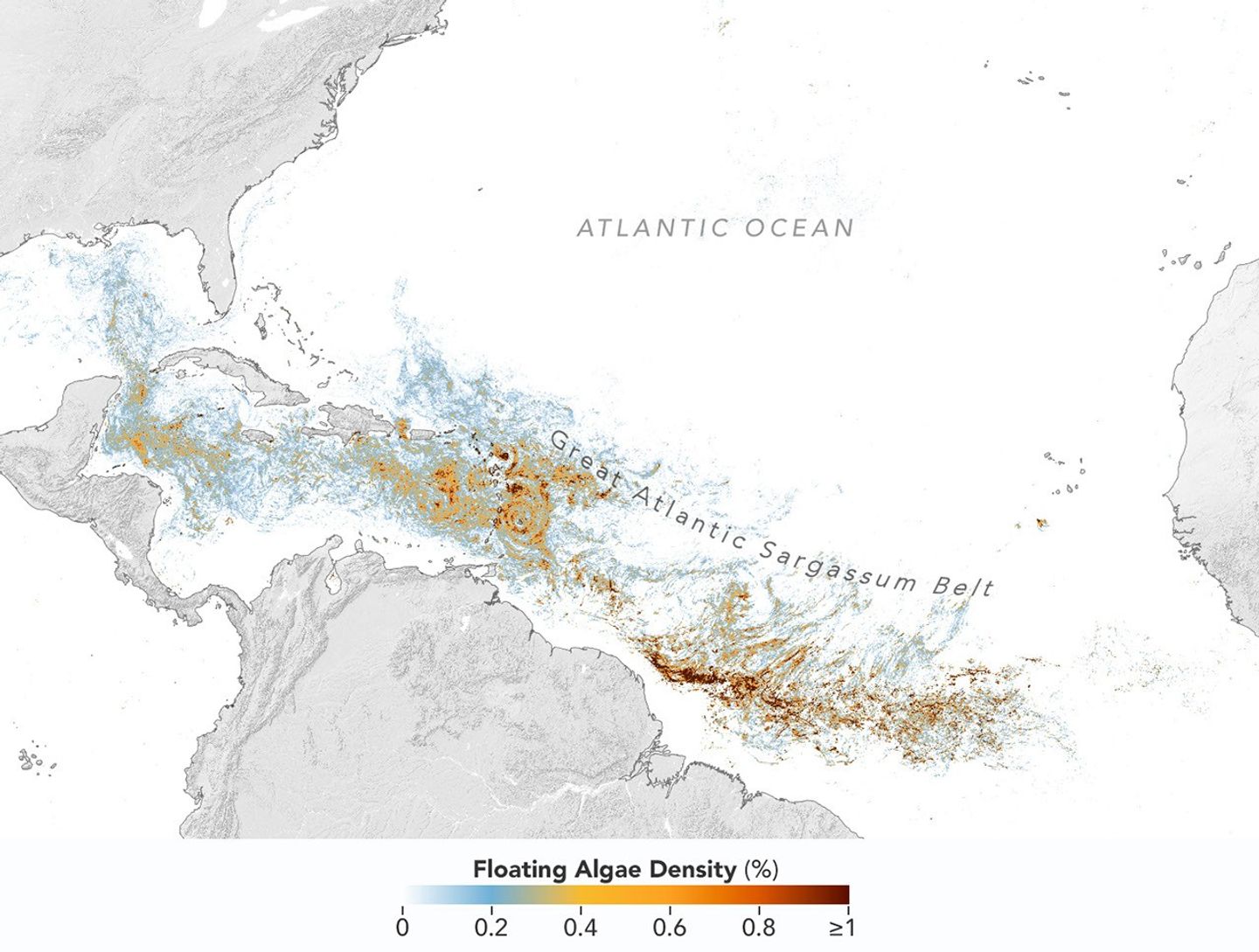
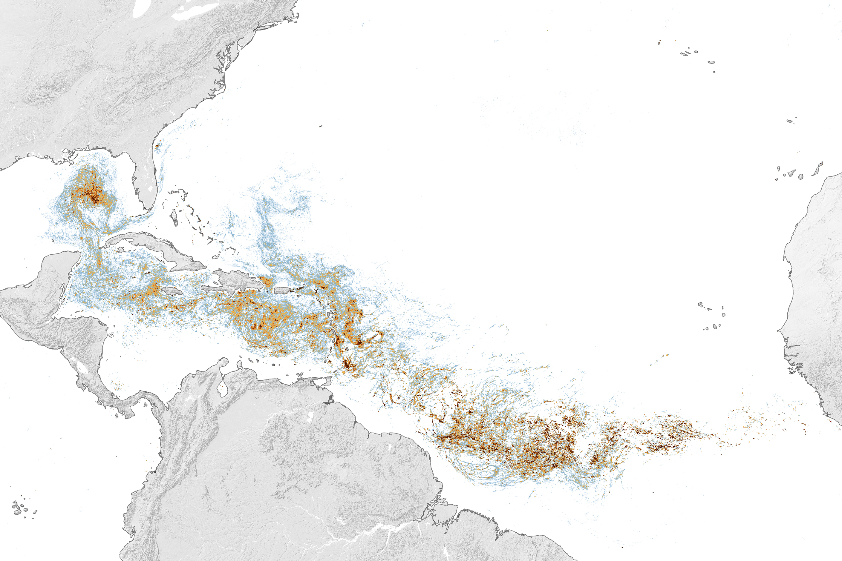
This map, based on data from the OCI (Ocean Color Instrument) on NASA’s PACE (Plankton, Aerosol, Cloud, ocean Ecosystem) satellite, shows Sargassum highly concentrated in the tropical Atlantic in June 2026.
NASA Earth Observatory/Lauren Dauphin
Sargassum, a type of brown floating algae, has shifted its range in recent decades, thinning out in the North Atlantic’s Sargasso Sea while proliferating in the tropical Atlantic. That trend, underway since 2011, continued in 2026 as the algae, commonly known as a type of seaweed, reached its annual peak in June across a stretch of ocean known as the Great Atlantic Sargassum Belt.
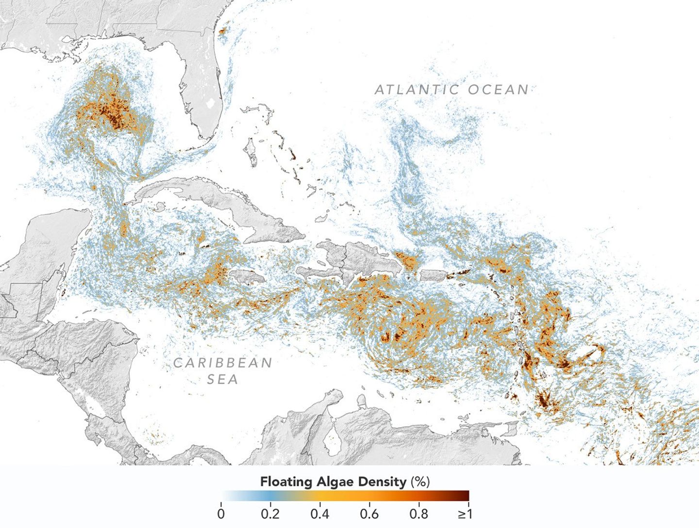
The belt’s Sargassum abundance in June 2026 made it the second-highest Sargassum year in the satellite record, slightly behind 2025, according to scientists at the University of South Florida (USF) College of Marine Science. Regionally, the Caribbean Sea and the Gulf of America (Gulf of Mexico) both hit record highs, according to USF’s June 2026Sargassum outlook. The western and eastern Caribbean saw 3.6 and 9 million metric tons, respectively, while the Gulf saw 5 million metric tons—nearly double its previous record, also set in 2025.
“The belt is a basin-scale phenomenon that can have devastating local-scale impacts throughout the Caribbean and Gulf, and satellite observations are the only method that captures both scales on a daily basis,” said Brian Barnes, a marine scientist at the Optical Oceanography Laboratory at USF. “The tracking done by our lab helps communities know the current extent of Sargassum and prepare for what’s to come.”
In moderate amounts in the open ocean, Sargassum provides habitat for turtles, invertebrates, fish, and birds, and adds oxygen to the water through photosynthesis. But too much of it near shore can tangle and suffocate marine life, and mats that sink can smother corals and seagrasses. On beaches, decomposing Sargassum releases hydrogen sulfide, a rotten-egg-smelling gas that’s a potential problem for both ecosystems and tourism.
The map above shows Sargassum density in the tropical Atlantic Ocean in June 2026. Red and orange areas are where Sargassum densities were the highest. Note that although the “belt” appears continuous, discrete Sargassum mats are scattered across the ocean surface. The map is based on satellite measurements of how much of the ocean surface was covered by the seaweed, averaged per pixel across all observations made in June by the OCI (Ocean Color Instrument) on NASA’s PACE (Plankton, Aerosol, Cloud, ocean Ecosystem) satellite.
This detailed view of the same PACEOCI map highlights Sargassum concentrations across the Caribbean Sea and Gulf of America, both of which saw record-high amounts of the floating algae in June 2026.
NASA Earth Observatory/Lauren Dauphin
Ocean currents and winds shape the Sargassum belt, which, despite the patchiness, stretches nearly continuously from West Africa to the Gulf and holds a fairly steady “width” from the western tropical Atlantic westward, explained Chuanmin Hu, also an optical oceanographer at USF. The ocean currents have also spared Florida’s west coast from inundation this summer, while delivering large amounts of seaweed to the Florida Keys and the state’s east coast. The bulk of the Sargassum, however, is visible in the Caribbean Sea, shown in detail above, where problems associated with inundation have been more severe, Hu said.
Data for the maps were provided by Lin Qi, an oceanographer at NOAA’s Center for Satellite Applications and Research, who has been working to generate Sargassum maps based on data from PACE, which was launched in February 2024. The work extends that of Qi and colleagues at USF’s Optical Oceanography Laboratory. This team first developed Sargassum detection techniques using MODIS (Moderate Resolution Imaging Spectroradiometer) on NASA’s long-running Terra and Aqua satellites and VIIRS (Visible Infrared Imaging Radiometer Suite) on the NOAA-20 satellite—data that have been a key component of USF’s Sargassum Watch System and of research into the seaweed’s longer-term trends.
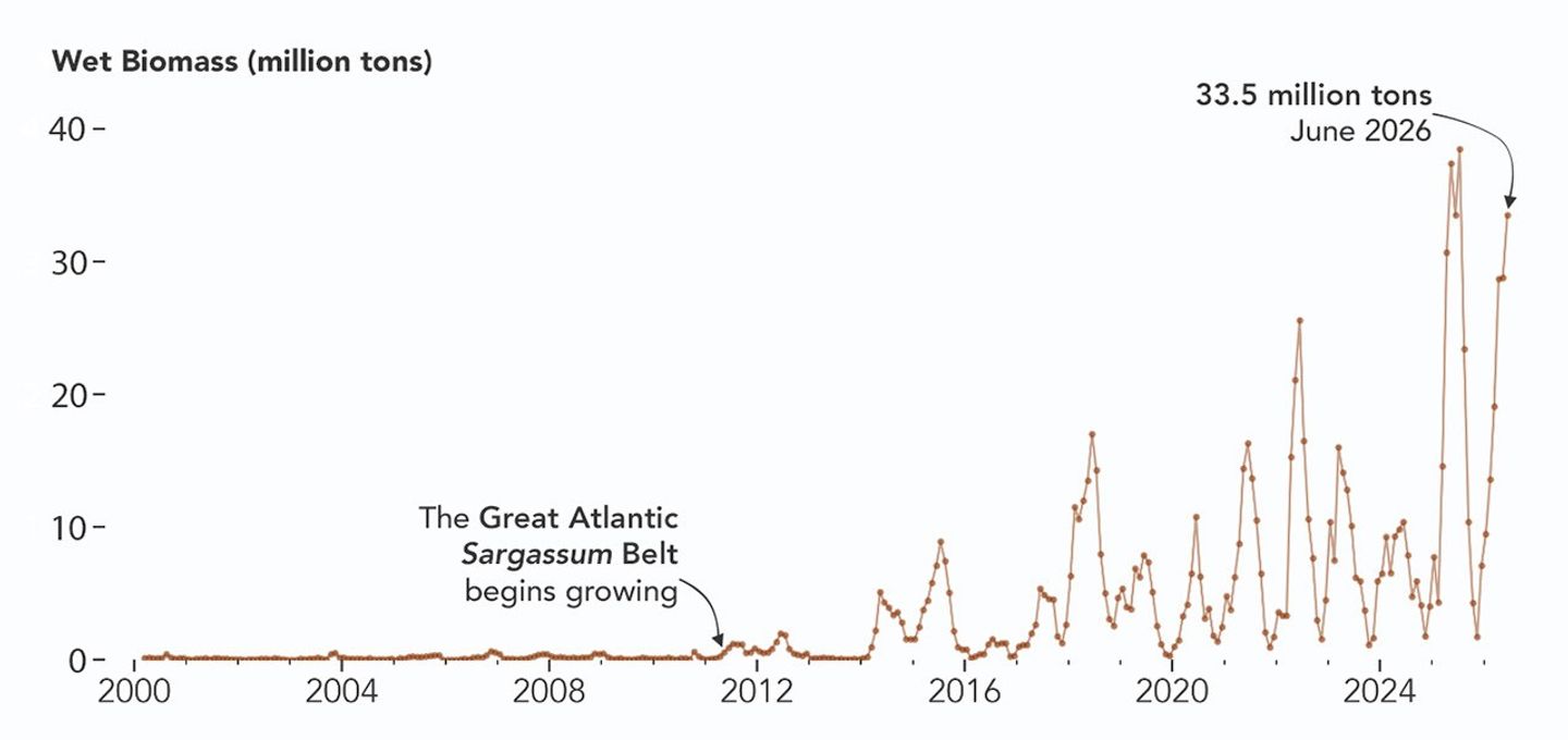
Satellites detect Sargassum by its signals in reflected sunlight. Because of its plant structure and chlorophyll pigments, Sargassum reflects more near-infrared light than water. Scientists flag pixels where the reflectance spikes above the levels produced by plain seawater, and then they use the strength of this spike to estimate Sargassum density, which refers to the fraction of ocean surface covered by the seaweed in each pixel. Density estimates can then be converted into biomass, or the total weight of Sargassum present within a pixel, which is how the longer-term trends in the chart below are tracked.
NASA Earth Observatory/Lauren Dauphin
The chart above uses the continuous MODIS record since March 2000 to show how Sargassum biomass across the Great Atlantic Sargassum Belt has changed through June 2026. Notice the uptick beginning around 2011, when the belt was first developing, and the seasonal dips in winter and peaks in spring and summer. The record high in July 2025 stands out, followed by the quick rise in early 2026—especially in the first four months of the year—that culminated in the year’s peak in June. More recent observations, not yet reflected in the chart, indicate Sargassum biomass declined through the following month of July.
“Since the initial appearance of the Great Atlantic Sargassum Belt in 2011, the total Sargassum amount in the Atlantic Ocean has increased substantially, more than doubling every five years,” Hu said. He added that the exact mechanism is still being investigated, but it’s possibly related to ocean warming, multiple nutrient sources, and the fact that large Sargassum mats attract other organisms—such as nitrogen-fixing bacteria—that can supply additional nutrients to sustain further growth.
Alongside data from MODIS and VIIRS, OCI data from PACE now feeds into the Sargassum Watch System’s near-real-time daily and weekly composite maps. A recent study of the central-west Atlantic led by Qi, spanning May through August 2024, found that OCI offers several advantages over its predecessors, observing more of the ocean and detecting Sargassum with greater sensitivity.
Hu noted that the added pixels from OCI can improve near-real-time monitoring and analyses of short-term fluctuations. And its higher sensitivity, he said, will also lead to improved maps during winter months, “thus helping understand Sargassum changes over time.”
Additionally, the study’s authors found that OCI’s hyperspectral capability makes it the only sensor able to spectrally discriminate Sargassum pixels across the Atlantic Ocean “without ambiguity,” adding confidence to the interpretation of detected image features—especially in parts of the Atlantic where another type of floating algae, Trichodesmium, has been reported.
“I think I can speak for all project members, past and present, in sharing how rewarding it is to see the promise of PACE’s advancements come to life,” said Jeremy Werdell, PACE project scientist at NASA’s Goddard Space Flight Center. “OCI has started a true renaissance in aquatic ecosystem monitoring from space.”
NASA Earth Observatory maps and chart by Lauren Dauphin, using PACE and MODIS data courtesy of Lin Qi (NOAA), and Brian Barnes and Chuanmin Hu (University of South Florida, Optical Oceanography Laboratory). Story by Kathryn Hansen.
CapuchinAI, a portable testing station equipped with a touch screen and facial recognition software, could help scientists study primate intelligence in the wild.
A self-taught ornithologist, he won a MacArthur fellowship for his precise, resplendent illustrations that appeared in definitive field guides to tropical songbirds.
Las excavaciones sistemáticas que desde 2020 se desarrollan en la llanura de Mancicerta (en turco Malazgirt), en el este de Anatolia, han proporcionado un nuevo conjunto de evidencias materiales que permiten precisar las operaciones militares desarrolladas en el entorno de la fortaleza durante la segunda mitad del siglo XI. El ministro de Cultura y Turismo […]
Un hallazgo en el yacimiento de Minferri, en la localidad leridana de Juneda, ha venido a trastocar por completo la cronología establecida para la metalurgia del plomo en la península ibérica. Las investigaciones desarrolladas en este enclave de la Edad del Bronce, cuyos resultados se acaban de publicar en la revista científica Antiquity, sitúan la […]
La publicación en la revista PNAS Nexus de nuevas evidencias procedentes de Malta ha sacudido los cimientos de lo que se creía saber sobre las capacidades marítimas de los últimos cazadores-recolectores europeos. El descubrimiento de que las islas del Mediterráneo central fueron colonizadas antes de la invención de la agricultura contradice directamente las concepciones establecidas […]

 Login