❌

Normal view

Playing the Moon Game 

24 June 2026 at 05:01
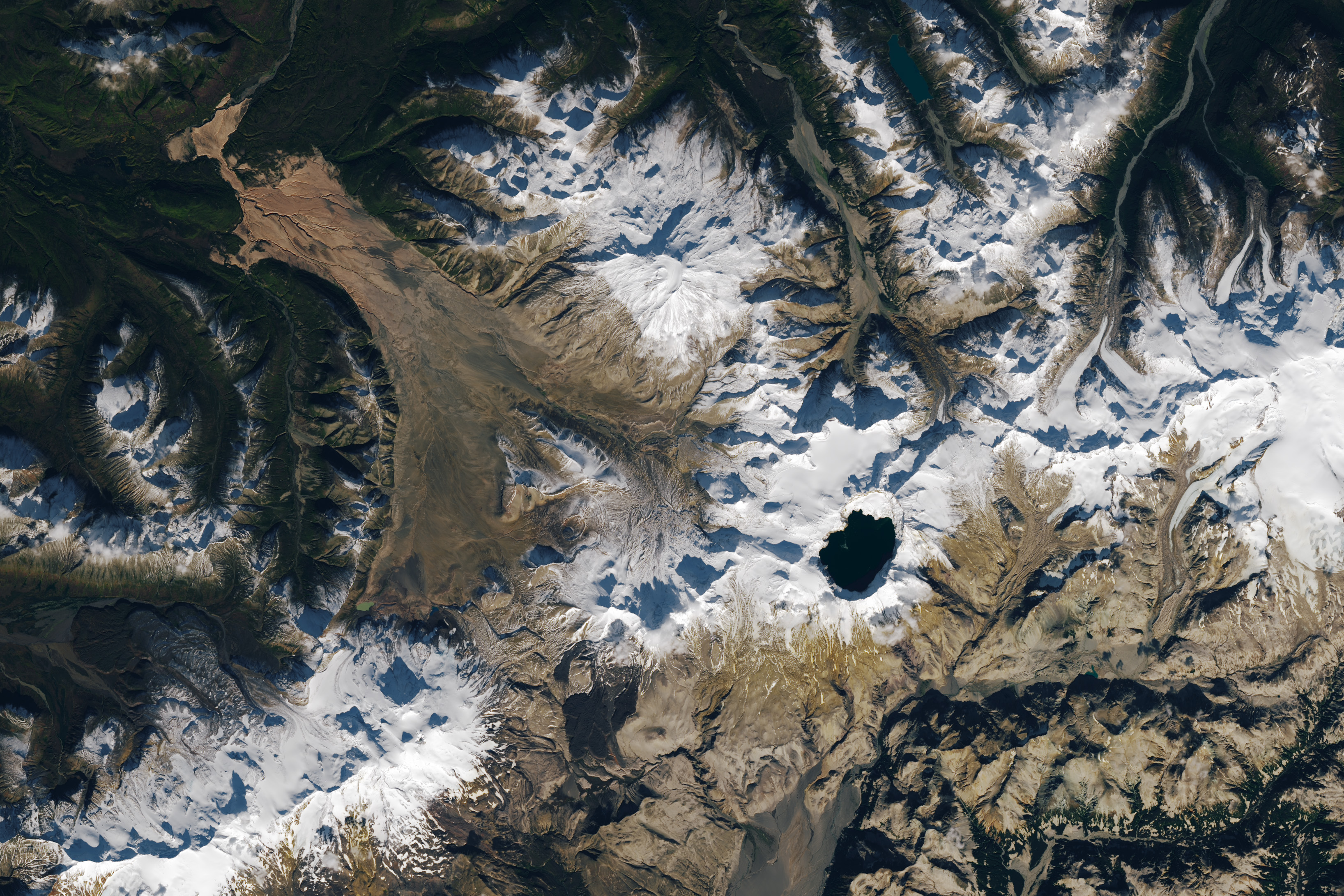
A satellite image shows part of Alaska’s Katmai National Park. A chain of snowy mountain peaks stretches from the bottom left corner to the right side of the image. The Valley of Ten Thousand Smokes is a long, tan-colored feature runs toward the northwest in the upper-left.
September 29, 2025

In preparing to visit the Moon’s surface, soon-to-be lunar explorers in NASA’s Apollo program first ventured into a variety of unfamiliar landscapes on Earth. A couple of these trips, in the summers of 1965 and 1966, took astronauts to Alaska’s remote Katmai National Park for simulations of field geology in Moon-like environments.

In one exercise, which they called “playing the Moon game,” pairs of astronauts were placed at unfamiliar field sites and asked to pretend as if they were on the Moon. By the account of William Phinney, Apollo’s science training coordinator, they were tasked with collecting representative geologic samples and practicing how to communicate their observations to scientists.

A detailed satellite image centers on the Valley of Ten Thousand Smokes in Alaska. The tan-colored feature runs southeast-to-northwest. Snowy peaks appear on the right side of the image, and green, forested valleys fill the left side.
September 29, 2025

The Alaskan setting for the Moon game was an unusual volcanic landscape called the Valley of Ten Thousand Smokes. The valley is full of debris deposited by the 1912 eruption of Novarupta—the largest volcanic event on Earth in the 20th century.

The images above, acquired on September 29, 2025, with the OLI (Operational Land Imager) on Landsat 9, show the massive ash flow deposited by Novarupta. The layer measures up to 660 feet (200 meters) thick and was emplaced at a searing 1,380 degrees Fahrenheit (750 degrees Celsius). 

The Valley of Ten Thousand Smokes, shown in the 1917 photo below, is so named because of the abundance of fumaroles—gas and steam-emitting vents—that filled the valley for a decade after the eruption. A few hundred persisted more than 10 years, with some lasting until the 1990s.

Three people stand in the foreground of this black-and-white photo, silhouetted by steam coming from a fumarole. A dark, barren landscape dotted with plumes of rising steam extends into the background.
1917

Scientists initially suspected that the monster eruption occurred at Mount Katmai, a neighboring volcano with a large caldera located 6 miles (10 kilometers) east of Novarupta’s dome. However, they later determined that the eruption actually occurred at Novarupta—whose name means “new eruption”—after stealing magma from beneath Katmai. As the magma chamber emptied, Katmai collapsed, forming the 2.5-mile-wide (4-kilometer-wide) caldera present today.

The volcanic landscape in the Valley of Ten Thousand Smokes is far fresher than the ancient lava flows that formed the Moon’s volcanic features. But for the Apollo astronauts, it offered an “excellent opportunity to view volcanic materials and landforms in nearly pristine condition,” Phinney wrote. They studied evidence of fumaroles and examined vertical sections of the deposits where streams had eroded deep gorges.

This photo shows a broad valley filled with tan-colored volcanic material in the foreground and snowy mountains in the background. The ashy volcanic deposits create a mostly flat valley floor, except where steep-sided chasms formed by erosion run through it.
June 9, 1991

Researchers continue to visit this Alaskan wilderness in search of clues that could help decipher the geology of the Moon and Mars. In 2024, the Goddard Instrument Field Team (GIFT) trekked to the Valley of Ten Thousand Smokes to study its icy volcanic landscape. Like the valley, Mars contains glaciers and ice sheets layered with dust and ash, a dynamic and difficult-to-interpret environment.

Advancing lunar science, the GIFT team also collected samples from rock formations comparable to the Moon’s Gruithuisen Domes. These mysterious features are made of hardened lava with a different composition than the surrounding rock. With more to learn about our nearest celestial neighbor, the spirit of the Moon game lives on in the 21st century.

NASA Earth Observatory images by Lauren Dauphin, using Landsat data from the U.S. Geological Survey. Photos from National Geographic Society Katmai expeditions photographs, Archives and Special Collections, Consortium Library, University of Alaska Anchorage, and from the U.S. Geological Survey Volcano Hazards Program. Story by Lindsey Doermann. 

Downloads

A satellite image shows part of Alaska’s Katmai National Park. A chain of snowy mountain peaks stretches from the bottom left corner to the right side of the image. The Valley of Ten Thousand Smokes is a long, tan-colored feature runs toward the northwest in the upper-left.

September 29, 2025

JPEG (2.64 MB)

References & Resources

You may also be interested in:

Stay up-to-date with the latest content from NASA as we explore the universe and discover more about our home planet.

Scoria Cones on Earth and Mars

7 min read

The hill-shaped features are a sign of explosive volcanic activity—a rarity on the Red Planet.

Article

A Volcanic Medley Near Mammoth Lakes 

4 min read

A massive, old caldera and more recently formed craters shape the landscape in the eastern Sierra Nevada.

Article

A Full Moon Checkup

3 min read

Once a month during the full Moon, Landsat 9 turns from Earth to image the lunar surface, helping keep the…

Article

Playing the Moon Game 

24 June 2026 at 05:01
A satellite image shows part of Alaska’s Katmai National Park. A chain of snowy mountain peaks stretches from the bottom left corner to the right side of the image. The Valley of Ten Thousand Smokes is a long, tan-colored feature runs toward the northwest in the upper-left.
September 29, 2025

In preparing to visit the Moon’s surface, soon-to-be lunar explorers in NASA’s Apollo program first ventured into a variety of unfamiliar landscapes on Earth. A couple of these trips, in the summers of 1965 and 1966, took astronauts to Alaska’s remote Katmai National Park for simulations of field geology in Moon-like environments.

In one exercise, which they called “playing the Moon game,” pairs of astronauts were placed at unfamiliar field sites and asked to pretend as if they were on the Moon. By the account of William Phinney, Apollo’s science training coordinator, they were tasked with collecting representative geologic samples and practicing how to communicate their observations to scientists.

A detailed satellite image centers on the Valley of Ten Thousand Smokes in Alaska. The tan-colored feature runs southeast-to-northwest. Snowy peaks appear on the right side of the image, and green, forested valleys fill the left side.
September 29, 2025

The Alaskan setting for the Moon game was an unusual volcanic landscape called the Valley of Ten Thousand Smokes. The valley is full of debris deposited by the 1912 eruption of Novarupta—the largest volcanic event on Earth in the 20th century.

The images above, acquired on September 29, 2025, with the OLI (Operational Land Imager) on Landsat 9, show the massive ash flow deposited by Novarupta. The layer measures up to 660 feet (200 meters) thick and was emplaced at a searing 1,380 degrees Fahrenheit (750 degrees Celsius). 

The Valley of Ten Thousand Smokes, shown in the 1917 photo below, is so named because of the abundance of fumaroles—gas and steam-emitting vents—that filled the valley for a decade after the eruption. A few hundred persisted more than 10 years, with some lasting until the 1990s.

Three people stand in the foreground of this black-and-white photo, silhouetted by steam coming from a fumarole. A dark, barren landscape dotted with plumes of rising steam extends into the background.
1917

Scientists initially suspected that the monster eruption occurred at Mount Katmai, a neighboring volcano with a large caldera located 6 miles (10 kilometers) east of Novarupta’s dome. However, they later determined that the eruption actually occurred at Novarupta—whose name means “new eruption”—after stealing magma from beneath Katmai. As the magma chamber emptied, Katmai collapsed, forming the 2.5-mile-wide (4-kilometer-wide) caldera present today.

The volcanic landscape in the Valley of Ten Thousand Smokes is far fresher than the ancient lava flows that formed the Moon’s volcanic features. But for the Apollo astronauts, it offered an “excellent opportunity to view volcanic materials and landforms in nearly pristine condition,” Phinney wrote. They studied evidence of fumaroles and examined vertical sections of the deposits where streams had eroded deep gorges.

This photo shows a broad valley filled with tan-colored volcanic material in the foreground and snowy mountains in the background. The ashy volcanic deposits create a mostly flat valley floor, except where steep-sided chasms formed by erosion run through it.
June 9, 1991

Researchers continue to visit this Alaskan wilderness in search of clues that could help decipher the geology of the Moon and Mars. In 2024, the Goddard Instrument Field Team (GIFT) trekked to the Valley of Ten Thousand Smokes to study its icy volcanic landscape. Like the valley, Mars contains glaciers and ice sheets layered with dust and ash, a dynamic and difficult-to-interpret environment.

Advancing lunar science, the GIFT team also collected samples from rock formations comparable to the Moon’s Gruithuisen Domes. These mysterious features are made of hardened lava with a different composition than the surrounding rock. With more to learn about our nearest celestial neighbor, the spirit of the Moon game lives on in the 21st century.

NASA Earth Observatory images by Lauren Dauphin, using Landsat data from the U.S. Geological Survey. Photos from National Geographic Society Katmai expeditions photographs, Archives and Special Collections, Consortium Library, University of Alaska Anchorage, and from the U.S. Geological Survey Volcano Hazards Program. Story by Lindsey Doermann. 

Downloads

A satellite image shows part of Alaska’s Katmai National Park. A chain of snowy mountain peaks stretches from the bottom left corner to the right side of the image. The Valley of Ten Thousand Smokes is a long, tan-colored feature runs toward the northwest in the upper-left.

September 29, 2025

JPEG (2.64 MB)

References & Resources

You may also be interested in:

Stay up-to-date with the latest content from NASA as we explore the universe and discover more about our home planet.

Scoria Cones on Earth and Mars
7 min read

The hill-shaped features are a sign of explosive volcanic activity—a rarity on the Red Planet.

Article
A Volcanic Medley Near Mammoth Lakes 
4 min read

A massive, old caldera and more recently formed craters shape the landscape in the eastern Sierra Nevada.

Article
Restless Kīlauea Launches Lava and Ash
3 min read

Episode 43 of the Hawaiian volcano’s current eruption was marked by high lava fountains and widespread ash dispersal.

Article

The post Playing the Moon Game  appeared first on NASA Science.

El Niño Is Underway

18 June 2026 at 05:00
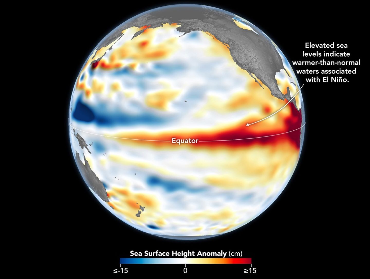
A global map centered on the Pacific Ocean shows a band of red, higher-than-normal water levels across the central and eastern equatorial Pacific and a broad patch off the coast of South America.
Higher-than-normal sea surfaces (red) are visible in the central and eastern Pacific on June 8, 2026, a few days before El Niño was declared. Data for the map were acquired by the Sentinel-6 Michael Freilich satellite and processed by scientists at NASA’s Jet Propulsion Laboratory (JPL).
NASA Earth Observatory/Lauren Dauphin

El Niño, characterized by warmer-than-normal water temperatures in parts of the equatorial Pacific, made its return in June 2026. Observations of sea surface height from the Sentinel-6 Michael Freilich satellite that month indicated that the 2026 event was continuing to strengthen.  

The natural, recurring phenomenon can have widespread effects, typically bringing wetter conditions to the U.S. Southwest and drought to countries in the western Pacific, such as Indonesia and Australia. NOAA declared an El Niño on June 11, after sea surface temperatures in the central and eastern equatorial Pacific measured at least 0.5 degrees Celsius above average for several consecutive months.

Meanwhile, NASA scientists have been observing a complementary sign of El Niño: areas of elevated sea surface height. When ocean water warms, it expands in volume and causes the sea surface to rise—making the water’s height a reliable indicator of ocean temperatures. Warmer-than-normal temperatures, hence higher sea surface heights, in parts of the equatorial Pacific Ocean are associated with El Niño.

The map above depicts sea surface height anomalies across the central and eastern Pacific Ocean as observed on June 8, 2026. Shades of red indicate sea levels that were higher than average. Normal sea level conditions appear white, and lower areas are blue.  

Data for the map were acquired by the Sentinel-6 Michael Freilich satellite—launched in 2020 by NASA and led by ESA (European Space Agency)—and processed by scientists at NASA’s Jet Propulsion Laboratory (JPL). Note that signals related to seasonal cycles and long-term trends have been removed to highlight sea level anomalies associated with El Niño and other short-term natural phenomena.

Earlier in spring 2026, the satellite started to detect precursor signs of El Niño as swells of warm water hundreds of miles wide, known as Kelvin waves, moved from the western Pacific to the eastern Pacific. That happens when trade winds in the western equatorial Pacific weaken and then temporarily reverse to blow from the west. Warm water piles up in the east, deepening the warm surface layer, lowering the thermocline, and suppressing the upwelling that usually keeps waters along the Pacific coasts of the Americas cooler.

This buildup of heat beneath the water’s surface is what sea surface height observations capture. It goes beyond surface temperature measurements to indicate how much heat is stored in the subsurface. That’s important because a shallow warm layer might not have much impact on climate and weather, while a large reservoir of heat below the surface can matter more.

According to JPL sea level researcher Severine Fournier, deputy project scientist for Sentinel-6 Michael Freilich, conditions in the western Pacific on June 8 looked similar to those from the same time in 1997, a year when an exceptionally strong El Niño emerged. Warm conditions in the eastern Pacific in 2026 have lagged behind, however, with fewer Kelvin waves built up by the same date.

Still, more warm Kelvin waves appeared to be approaching the eastern Pacific, meaning El Niño was still strengthening. Whether it catches up to 1997 depends on ocean activity in the coming weeks. “For now, it looks like it’s going to be a big one—more so than I would have said last week—but we still need more observations to know what’s going to happen.”

NASA Earth Observatory image by Lauren Dauphin, using modified Copernicus Sentinel data (2023) processed by the European Space Agency and further processed by Josh Willis, Severin Fournier, and Kevin Marlis/NASA/JPL-Caltech. Story by Kathryn Hansen.

Downloads

A global map centered on the Pacific Ocean shows a band of red, higher-than-normal water levels across the central and eastern equatorial Pacific and a broad patch off the coast of South America.

June 8, 2026

JPEG (1.19 MB)

References & Resources

You may also be interested in:

Stay up-to-date with the latest content from NASA as we explore the universe and discover more about our home planet.

Barents Sea Tied to Low Arctic Sea Ice
4 min read

Patches of open water in the region contributed to low sea ice extent across the Arctic in March 2026, which…

Article
New Eruption in the Bismarck Sea
5 min read

Satellite imagery shows a surge of new volcanic activity in the ocean near Papua New Guinea.

Article
Color Off the Mid-Atlantic Coast
4 min read

Something is brewing in shallow waters offshore of Delaware, New Jersey, Maryland, and Virginia.

Article

The post El Niño Is Underway appeared first on NASA Science.

El Niño Is Underway

18 June 2026 at 05:00
A global map centered on the Pacific Ocean shows a band of red, higher-than-normal water levels across the central and eastern equatorial Pacific and a broad patch off the coast of South America.
Higher-than-normal sea surfaces (red) are visible in the central and eastern Pacific on June 8, 2026, a few days before El Niño was declared. Data for the map were acquired by the Sentinel-6 Michael Freilich satellite and processed by scientists at NASA’s Jet Propulsion Laboratory (JPL).
NASA Earth Observatory/Lauren Dauphin

El Niño, characterized by warmer-than-normal water temperatures in parts of the equatorial Pacific, made its return in June 2026. Observations of sea surface height from the Sentinel-6 Michael Freilich satellite that month indicated that the 2026 event was continuing to strengthen.  

The natural, recurring phenomenon can have widespread effects, typically bringing wetter conditions to the U.S. Southwest and drought to countries in the western Pacific, such as Indonesia and Australia. NOAA declared an El Niño on June 11, after sea surface temperatures in the central and eastern equatorial Pacific measured at least 0.5 degrees Celsius above average for several consecutive months.

Meanwhile, NASA scientists have been observing a complementary sign of El Niño: areas of elevated sea surface height. When ocean water warms, it expands in volume and causes the sea surface to rise—making the water’s height a reliable indicator of ocean temperatures. Warmer-than-normal temperatures, hence higher sea surface heights, in parts of the equatorial Pacific Ocean are associated with El Niño.

The map above depicts sea surface height anomalies across the central and eastern Pacific Ocean as observed on June 8, 2026. Shades of red indicate sea levels that were higher than average. Normal sea level conditions appear white, and lower areas are blue.  

Data for the map were acquired by the Sentinel-6 Michael Freilich satellite—launched in 2020 by NASA and led by ESA (European Space Agency)—and processed by scientists at NASA’s Jet Propulsion Laboratory (JPL). Note that signals related to seasonal cycles and long-term trends have been removed to highlight sea level anomalies associated with El Niño and other short-term natural phenomena.

Earlier in spring 2026, the satellite started to detect precursor signs of El Niño as swells of warm water hundreds of miles wide, known as Kelvin waves, moved from the western Pacific to the eastern Pacific. That happens when trade winds in the western equatorial Pacific weaken and then temporarily reverse to blow from the west. Warm water piles up in the east, deepening the warm surface layer, lowering the thermocline, and suppressing the upwelling that usually keeps waters along the Pacific coasts of the Americas cooler.

This buildup of heat beneath the water’s surface is what sea surface height observations capture. It goes beyond surface temperature measurements to indicate how much heat is stored in the subsurface. That’s important because a shallow warm layer might not have much impact on climate and weather, while a large reservoir of heat below the surface can matter more.

According to JPL sea level researcher Severine Fournier, deputy project scientist for Sentinel-6 Michael Freilich, conditions in the western Pacific on June 8 looked similar to those from the same time in 1997, a year when an exceptionally strong El Niño emerged. Warm conditions in the eastern Pacific in 2026 have lagged behind, however, with fewer Kelvin waves built up by the same date.

Still, more warm Kelvin waves appeared to be approaching the eastern Pacific, meaning El Niño was still strengthening. Whether it catches up to 1997 depends on ocean activity in the coming weeks. “For now, it looks like it’s going to be a big one—more so than I would have said last week—but we still need more observations to know what’s going to happen.”

NASA Earth Observatory image by Lauren Dauphin, using modified Copernicus Sentinel data (2023) processed by the European Space Agency and further processed by Josh Willis, Severin Fournier, and Kevin Marlis/NASA/JPL-Caltech. Story by Kathryn Hansen.

Downloads

A global map centered on the Pacific Ocean shows a band of red, higher-than-normal water levels across the central and eastern equatorial Pacific and a broad patch off the coast of South America.

June 8, 2026

JPEG (1.19 MB)

References & Resources

You may also be interested in:

Stay up-to-date with the latest content from NASA as we explore the universe and discover more about our home planet.

Barents Sea Tied to Low Arctic Sea Ice
4 min read

Patches of open water in the region contributed to low sea ice extent across the Arctic in March 2026, which…

Article
New Eruption in the Bismarck Sea
5 min read

Satellite imagery shows a surge of new volcanic activity in the ocean near Papua New Guinea.

Article
Color Off the Mid-Atlantic Coast
4 min read

Something is brewing in shallow waters offshore of Delaware, New Jersey, Maryland, and Virginia.

Article

Nebraska’s Wide, Rolling Domain

16 June 2026 at 05:01
The landscape in northwestern Nebraska has a rippled appearance, with tan parallel ridges running from left to right and green areas and small lakes filling the low-lying spaces in between.
The Nebraska Sandhills stretch across the north-central part of the state in this image acquired on August 19, 2025, with the OLI (Operational Land Imager) on Landsat 8.
NASA Earth Observatory/Lauren Dauphin

Editor’s Note: Today’s story is the answer to the June Puzzler.

The undulating landscape of north-central Nebraska may be easy to overlook among the iconic dune fields of the world. Far from any coast or desert, the Nebraska Sandhills—comprising the Western Hemisphere’s largest system of sand dunes—bring their own brand of beauty and value. Grasslands blanket the rolling hills, providing grazing grounds for livestock, while lakes and wetlands dot the landscape, supporting diverse plant and animal life.

Much of the sand forming the hills originated in the Rocky Mountains. Rivers carried the eroded material down from the mountains and deposited it across the Great Plains during the Pleistocene. In times of drought, winds blowing predominantly from the north or south lofted sand out of dried riverbeds, gradually building and shaping dunes. About 3,500 years ago, grassland vegetation stabilized the features. Today, the rippled pattern spans about 20,000 square miles (52,000 square kilometers), about one-quarter of the state of Nebraska.

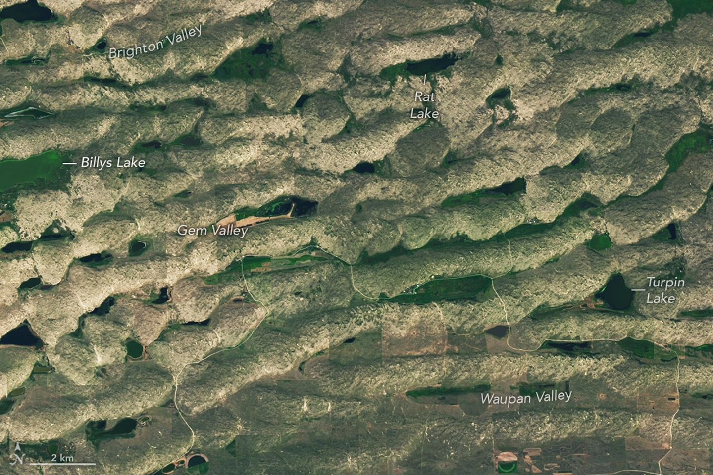
A series of tan parallel ridges runs from left to right, with green areas and small lakes filling the low-lying spaces in between.
Some of the largest, grassland-covered dunes in the Nebraska Sandhills are found in the northwestern part of the region, shown in this image acquired on August 19, 2025, with the OLI (Operational Land Imager) on Landsat 8.
NASA Earth Observatory/Lauren Dauphin

Some of the largest dunes occur in and around the area shown in the detailed image above, near the northern edge of the Sandhills region. These transverse dunes stand as high as 400 feet (120 meters) and extend for several miles. Their northern slopes are gentler than their southern slopes, reflecting the dominant influence of northerly winds. In other areas, dunes are more symmetric, suggesting that winds blew with nearly equal strength from the north and south, alternating with the seasons.  

The grasslands that now cover the hills constitute pastureland for grazing livestock. Ranching expanded significantly in the area after passage of the Kinkaid Act in 1904, which allotted 640-acre parcels of land to ranchers who would settle it. Today, far more cattle than humans occupy the region, and half of Nebraska’s nearly 23 million acres of rangeland and pastureland are in the Sandhills. Some ranchers graze their cattle in patterns meant to approximate the large bison herds that once roamed the land.

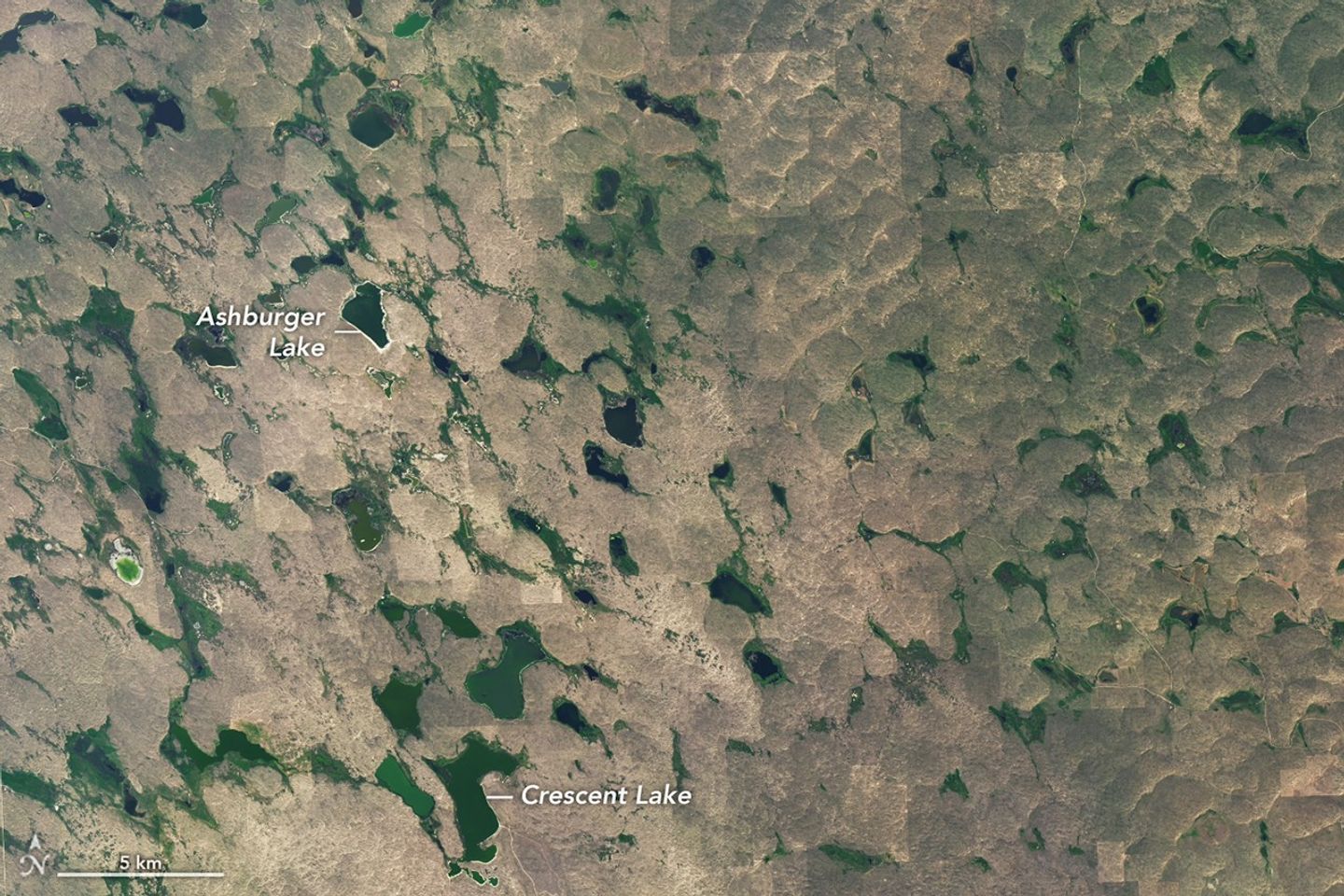
Small, irregularly shaped lakes and marshy areas are interspersed among tan hills.
Lakes and wetlands fill the valleys between dunes in Crescent Lake National Wildlife Refuge, shown in this image acquired on August 19, 2025, with the OLI (Operational Land Imager) on Landsat 8.
NASA Earth Observatory/Lauren Dauphin

Though much of the land in the Sandhills is privately owned, some is set aside in protected public lands. One of these areas, Crescent Lake National Wildlife Refuge on the southwestern edge of the Sandhills region, is shown above. Wetlands, including shallow lakes, marshes, and wet meadows, fill some of the valleys between the dunes. The land here is sponge-like, with precipitation seeping down through the soil and recharging groundwater instead of flowing off through stream channels.

Located along the Central Flyway, the refuge is a haven for migratory birds, and dozens of species of waterfowl, marsh birds, and shorebirds utilize the area. Among other wildlife, several types of turtles thrive in the ponds and prairies. Wetlands across the Sandhills support rare species such as the whooping crane, western prairie fringed orchid, and Topeka shiner.

NASA Earth Observatory images by Lauren Dauphin, using Landsat data from the U.S. Geological Survey. Story by Lindsey Doermann.

Downloads

The landscape in northwestern Nebraska has a rippled appearance, with tan parallel ridges running from left to right and green areas and small lakes filling the low-lying spaces in between.

August 19, 2025

JPEG (10.71 MB)

References & Resources

You may also be interested in:

Stay up-to-date with the latest content from NASA as we explore the universe and discover more about our home planet.

Fires Tear Through Nebraska Grasslands
3 min read

Dry, warm, and windy conditions across the U.S. Great Plains led to extreme fire activity in March 2026.

Article
Farming in Ancient Lake Agassiz
3 min read

The glacial lake left a layer of silt and clay in southeastern Manitoba, creating fertile farmland that was divided during…

Article
America’s Emerald Isle
3 min read

Beaver Island is one in a string of verdant and scenic jewels in a northern Lake Michigan archipelago.

Article

The post Nebraska’s Wide, Rolling Domain appeared first on NASA Science.

Nebraska’s Wide, Rolling Domain

16 June 2026 at 05:01
The landscape in northwestern Nebraska has a rippled appearance, with tan parallel ridges running from left to right and green areas and small lakes filling the low-lying spaces in between.
The Nebraska Sandhills stretch across the north-central part of the state in this image acquired on August 19, 2025, with the OLI (Operational Land Imager) on Landsat 8.
NASA Earth Observatory/Lauren Dauphin

Editor’s Note: Today’s story is the answer to the June Puzzler.

The undulating landscape of north-central Nebraska may be easy to overlook among the iconic dune fields of the world. Far from any coast or desert, the Nebraska Sandhills—comprising the Western Hemisphere’s largest system of sand dunes—bring their own brand of beauty and value. Grasslands blanket the rolling hills, providing grazing grounds for livestock, while lakes and wetlands dot the landscape, supporting diverse plant and animal life.

Much of the sand forming the hills originated in the Rocky Mountains. Rivers carried the eroded material down from the mountains and deposited it across the Great Plains during the Pleistocene. In times of drought, winds blowing predominantly from the north or south lofted sand out of dried riverbeds, gradually building and shaping dunes. About 3,500 years ago, grassland vegetation stabilized the features. Today, the rippled pattern spans about 20,000 square miles (52,000 square kilometers), about one-quarter of the state of Nebraska.

A series of tan parallel ridges runs from left to right, with green areas and small lakes filling the low-lying spaces in between.
Some of the largest, grassland-covered dunes in the Nebraska Sandhills are found in the northwestern part of the region, shown in this image acquired on August 19, 2025, with the OLI (Operational Land Imager) on Landsat 8.
NASA Earth Observatory/Lauren Dauphin

Some of the largest dunes occur in and around the area shown in the detailed image above, near the northern edge of the Sandhills region. These transverse dunes stand as high as 400 feet (120 meters) and extend for several miles. Their northern slopes are gentler than their southern slopes, reflecting the dominant influence of northerly winds. In other areas, dunes are more symmetric, suggesting that winds blew with nearly equal strength from the north and south, alternating with the seasons.  

The grasslands that now cover the hills constitute pastureland for grazing livestock. Ranching expanded significantly in the area after passage of the Kinkaid Act in 1904, which allotted 640-acre parcels of land to ranchers who would settle it. Today, far more cattle than humans occupy the region, and half of Nebraska’s nearly 23 million acres of rangeland and pastureland are in the Sandhills. Some ranchers graze their cattle in patterns meant to approximate the large bison herds that once roamed the land.

Small, irregularly shaped lakes and marshy areas are interspersed among tan hills.
Lakes and wetlands fill the valleys between dunes in Crescent Lake National Wildlife Refuge, shown in this image acquired on August 19, 2025, with the OLI (Operational Land Imager) on Landsat 8.
NASA Earth Observatory/Lauren Dauphin

Though much of the land in the Sandhills is privately owned, some is set aside in protected public lands. One of these areas, Crescent Lake National Wildlife Refuge on the southwestern edge of the Sandhills region, is shown above. Wetlands, including shallow lakes, marshes, and wet meadows, fill some of the valleys between the dunes. The land here is sponge-like, with precipitation seeping down through the soil and recharging groundwater instead of flowing off through stream channels.

Located along the Central Flyway, the refuge is a haven for migratory birds, and dozens of species of waterfowl, marsh birds, and shorebirds utilize the area. Among other wildlife, several types of turtles thrive in the ponds and prairies. Wetlands across the Sandhills support rare species such as the whooping crane, western prairie fringed orchid, and Topeka shiner.

NASA Earth Observatory images by Lauren Dauphin, using Landsat data from the U.S. Geological Survey. Story by Lindsey Doermann.

Downloads

The landscape in northwestern Nebraska has a rippled appearance, with tan parallel ridges running from left to right and green areas and small lakes filling the low-lying spaces in between.

August 19, 2025

JPEG (10.71 MB)

References & Resources

You may also be interested in:

Stay up-to-date with the latest content from NASA as we explore the universe and discover more about our home planet.

Fires Tear Through Nebraska Grasslands

3 min read

Dry, warm, and windy conditions across the U.S. Great Plains led to extreme fire activity in March 2026.

Article

Farming in Ancient Lake Agassiz

3 min read

The glacial lake left a layer of silt and clay in southeastern Manitoba, creating fertile farmland that was divided during…

Article

America’s Emerald Isle

3 min read

Beaver Island is one in a string of verdant and scenic jewels in a northern Lake Michigan archipelago.

Article
❌