
❌

Normal view

Colorful 'painting-like' ripples cover an ancient seafloor structure the Bahamas — Earth from space

7 July 2026 at 10:01
QUICK FACTS

Where is it? Great Bahama Bank, Bahamas [23.547188707, -76.46352937]

What's in the photo? Submerged sandbanks and seagrass beds in shallow water

Which satellite took the photo? Landsat 8

When was it taken? Feb. 15, 2020

This ethereal satellite snap shows beautiful, "painting-like" folds within an ancient underwater structure in the Bahamas.

The Great Bahama Bank (GBB) is a massive submerged platform stretching around 330 miles (530 kilometers) across a shallow ocean channel between Andros Island and the Exuma islands, according to Britannica. The crescent-shaped bank surrounds a darkly colored ocean drop-off known as "The Tongue of the Ocean," which plunges to depths of 6,500 feet (2,000 meters), according to NASA's Earth Observatory.

The photographed section of the GBB is around 23 miles (37 km) across and features a series of submerged sandbanks — most of which are covered with dense seagrass beds — that lie between 7 and 40 feet (2 to 12 m) below the ocean's surface.

The varying water depth and seagrass concentration cause multiple hues of green and blue to shine across the sandbanks, which have been carved into smooth, folding ribbons by ocean currents over thousands of years.

"The varying colors and curves remind us of graceful strokes on a painting," Earth Observatory representatives wrote.

A zoomed out satellite photo showing the Great Bahama Bank's location relative to other islands and the

The Great Bahama Bank is a crescent-shaped structure spanning around 330 miles (530 kilometers) between Andros Island and the Exuma islands. (Image credit: NASA/Landsat)

This section of the GBB was first photographed in 2001 by the Landsat 7 satellite and has often appeared on lists of the most iconic aerial images of our planet.

"There are many nice seagrass and sand patterns worldwide, but none like this anywhere on Earth," Serge Andréfouet, an oceanographer at the French National Research Institute for Sustainable Development who first shared the 2001 image, told the Earth Observatory. "I am not surprised it is still a favorite, especially for people who see it for the first time."

The sandbanks are like giant underwater dunes carved out by ocean currents.

"Tides and ocean currents in the Bahamas sculpted the sand and seaweed beds into these multicolored, fluted patterns in much the same way that winds sculpted the vast sand dunes in the Sahara Desert," Earth Observatory representatives wrote in 2001.

The GBB lies atop a roughly 3-mile-thick (5 km) bed of limestone dating to the age of the dinosaurs, more than 65 million years ago. This hefty mass, made up of the remains of long-dead coral reefs, is so large that Earth's crust directly below the GBB has "sagged under the weight," according to the University of Texas at Austin's Marine Science Institute.

A satellite photo of the Great Bahama bank showing the point where it drops off into the dark

The Great Bahama Bank surrounds the edge of a deep sea drop-off known as the "Tongue of the Ocean," creating a striking contrast when viewed from above. (Image credit: USGS/ESA)

Before the end of the last ice age, around 12,000 years ago, this limestone slab had risen to more than 400 feet (120 m) above sea level and only resubmerged as global sea levels rose due to the melting of glaciers, according to the Marine Science Institute.

The Bahamas has more than 3,000 islands and smaller cays and is home to several other intriguing oceanographic features, including deep tidal channels off the coast of Great Exuma Island (which once harbored famous pirate ships) and a series of aurora-like sandbanks that appear to shine along the nation's northernmost islands.

See more Earth from space

A satellite photo showing a group of islands in the Pacific Ocean with a glowing green ring of algae surrounding themGlowing ring of algae in New Zealand

A 2026 satellite photo captured a gleaming halo of phytoplankton encircling the remote Chatham Islands. The stunning sight is the result of a hidden underwater structure, which has also helped kill hundreds of cetaceans.

A beautiful light blue plume swirling in the sea off Key West'Arctic blast' paints plume in Florida

A 2026 satellite photo captured a stunning scene of sediment swirling across the West Florida Shelf after an extreme cold snap that covered large parts of the eastern U.S. in snow.

A satellite photo of a whale shaped island with a yellow circle highlighting to location of the Great Blue HoleWhale-shaped island in Belize

A 2020 astronaut photo shows the unusual cetacean-like shape of Belize's Lighthouse Reef. It's home to the famous Great Blue Hole, which doubles as the island's "blowhole" when viewed from space.

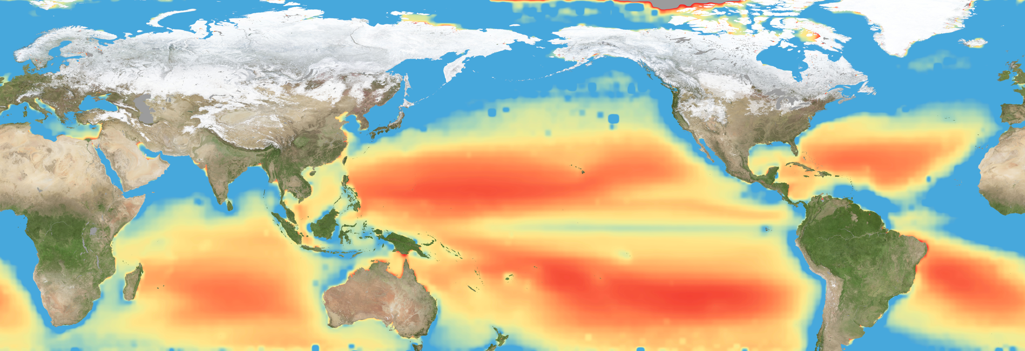
Atlantic 'cold blob' is responsible for shifts in the Indian summer monsoon that threaten over 1 billion people

A giant blob of abnormally cold water in the North Atlantic Ocean is shifting the Indian summer monsoon, threatening the livelihoods of more than 1 billion people, new research suggests.

The link between these two systems highlights a previously unrecognized connection that could inform weather forecasts in South Asia and shed light on climatic events elsewhere, scientists say.

The Indian summer monsoon is a rainfall pattern that lasts from June to September and is driven by temperature differences between the warm northern Indian Ocean and cooler seawater below the equator. Historically, the monsoon triggered heavy rainfall along the west coast of India and a huge region of northern India called the Indo-Gangetic Plain. But since 1999, this pattern has changed dramatically, the researchers reported in a new study.

Northwest India now receives about 25% more rain during the monsoon season than it did before 1999, while the Indo-Gangetic Plain gets roughly 4% less, the team found. This is disastrous for farmers, in particular, because their soils and crops are adapted to the old rainfall pattern, said study first author Mahendra Nimmakanti, a climate scientist at the Indian Institute of Science's Centre for Atmospheric and Oceanic Sciences.

"India is largely dependent on agriculture," Nimmakanti told Live Science in a joint interview with study co-author Matthew Huber, a professor in the Department of Earth, Atmospheric, and Planetary Sciences at Purdue University in Indiana. Higher-than-normal precipitation in northwest India is causing flash floods and crop losses, because agriculture in this region is adapted to dry conditions. Meanwhile, the Indo-Gangetic Plain has seen periods of drought that also caused crop declines and impacted farmers' livelihoods, Nimmakanti said.

Previous studies have linked shifts in the Indian summer monsoon to changes in the Atlantic Meridional Overturning Circulation (AMOC), a giant web of ocean currents in the Atlantic that regulates the global climate and carries heat to the Northern Hemisphere. Data suggests the AMOC is slowing due to climate change and releasing less heat in the North Atlantic Ocean than it did before. This may be causing a southward shift of the Intertropical Convergence Zone, a band of low-pressure atmospheric conditions around the equator that drives tropical monsoons, including the Indian summer monsoon.

But these studies didn't specify how the Indian monsoon might shift or explain the underlying mechanism in detail, Nimmakanti said. "They generally explain that if there is a weakening of AMOC, that suppresses the Indian summer monsoon," he said.

One part of the problem is that current climate models do not show the changes in the Indian monsoon that have happened in real life, possibly because they also don't fully capture shifts in North Atlantic sea surface temperatures. This is especially true for a region southeast of Greenland known as the "cold blob," where the water was colder between 1901 and 2021 than it was in the late 1800s, even as the ocean around it heated up.

The cold blob suggests the AMOC is weakening because it points to a reduction in the amount of heat reaching the North Atlantic.

To pinpoint how and why the Indian monsoon has changed, the researchers fed precipitation data, sea surface temperature records and other real-life observations into dozens of climate models. This reproduced the shifts observed over the past 27 years. However, the results only implied a correlation between shifts in the North Atlantic and changes in the monsoon, not that the former directly caused the latter.

People wade through floodwater after heavy monsoon rains in Karachi, Pakistan.

Northwest India now gets 25% more rain during the monsoon season than it did before 1999, and this shift has also increased flooding risk in Pakistan. (Image credit: Sabir Mazhar/Anadolu via Getty Images)

To figure out if North Atlantic sea surface temperatures caused the Indian monsoon to behave strangely, the team added and removed the cold blob in a simulation. The results showed that the cold blob has shifted the Indian monsoon by creating a strong temperature gradient over the North Atlantic, which, in turn, affects jet stream winds and pressure systems in the atmosphere above Eurasia.

Specifically, the jet stream above the North Atlantic has intensified, and a "blocking" system over the Ural Mountains in western Russia has strengthened, Huber said. As a result, weather systems in India have changed, sucking moist air toward the country's northwest and away from other regions.

"It's a shifting of the high- and low-pressure systems," Huber said. "Realizing that these two systems were directly linked through this wave train coming off the North Atlantic, that was novel."

More than 1 billion people in India and other parts of South Asia depend on the monsoon for food security and economic stability. The new results, published April 27 in the journal AGU Advances, could help forecasters predict extreme rainfall and drought events in India and neighboring countries like Pakistan during the monsoon season.

Some researchers think the Indian monsoon is a key tipping point within the global climate, and the findings suggest the system crossed a threshold in 1999. Since then, the cold blob has caused a "persistent jet stream reorganization," leading to abrupt shifts in the monsoon, according to the study.

It's unclear how the Indian monsoon will evolve under intensifying climate change, because climate models produce different predictions of what will happen in the North Atlantic, and other drivers may come into play as the world changes, Huber said.

"What we do now know is that this is one of the key building blocks of formulating a theory for what will happen in the future," he said.

Discovery of Ferric Iron-Bearing Majorite Crystallization from Deep Magma Oceans on Earth and Mars

16 June 2026 at 16:05

In the profound depths of rocky planets like Earth and Mars, the precise chemical states of mantle minerals play a foundational role in shaping planetary evolution. Among these chemical states, the oxidation state of iron profoundly influences mantle melting behaviors, volcanic gas compositions, and ultimately, the nature of a planet’s surface environment. While the elemental presence of iron in the mantle is well-known, the subtle balance between its ferrous (Fe²⁺) and ferric (Fe³⁺) forms remains a challenging frontier to unravel, particularly under the extreme pressures and temperatures encountered in planetary interiors.

The early stages of planetary formation are marked by the existence of a vast magma ocean—a molten silicate layer blanketing the young Earth and Mars. During this epoch, the oxidation state at which iron integrates into forming minerals dictates subsequent mantle properties and evolution. Accurately determining the Fe³⁺ content in minerals crystallized within this magma ocean stands as a critical step toward understanding the oxidation dynamics that influenced core-mantle differentiation and surface volatile release in nascent planets.

A mineral of prime relevance in this context is majorite, a high-pressure silicate phase stable at depths ranging roughly from 500 to 600 kilometers within Earth’s mantle and near the base of the Martian mantle. Its stability under simultaneously high-pressure and high-temperature conditions makes majorite a significant reservoir for iron deep within these planetary interiors. Therefore, quantifying the Fe³⁺ concentration hosted within majorite under early magma ocean conditions bears directly on models of mantle redox evolution and volatile mobility.

Researchers at Ehime University’s Geodynamics Research Center have pioneered the synthesis of Fe³⁺-rich majorite coexisting with molten silicate magma at pressures around 18 gigapascals and temperatures between 2150 and 2200 degrees Celsius. Utilizing a multi-anvil apparatus capable of reproducing these extreme conditions, the team closely simulated the environment of the early magma ocean. High-precision X-ray Absorption Near Edge Structure (XANES) spectroscopy was then employed at the renowned SPring-8 synchrotron facility to accurately assess the valence state of iron within the synthesized majorite crystals.

The findings reveal an unexpectedly high Fe³⁺ content in majorite crystallized from the magma ocean, second only to bridgmanite, Earth’s most abundant lower mantle mineral. This marked enrichment in ferric iron suggests that early mantle minerals could accommodate significant oxidation capacity, challenging earlier assumptions that high-pressure silicates predominantly contain iron in the ferrous state. The implication is that the early mantle harbored more oxidized iron species than previously anticipated, impacting mantle viscosity, melting relations, and the capacity to store volatile elements.

Importantly, as mantle solids ascend toward shallower depths, phase transitions or mineral decompositions can liberate excess Fe³⁺ that no longer fits within the crystal structures. This released ferric iron potentially contributes to the generation of oxidized magmas, influencing volcanic gas emissions and surface oxidation states. Such a mechanism presents a plausible link between deep mantle oxidation states and the chemical makeup of magmas erupted at the surface, offering fresh insights into the geological histories of both Earth and Mars.

The study’s revelations offer a new lens through which to interpret the evolution of mantle oxidation state gradients over geological time. Understanding how iron’s valence shifts across depth-dependent mineralogical boundaries and during mantle convection cycles will refine planetary differentiation models and volatile cycling frameworks. The presence of Fe³⁺-rich majorite highlights a previously underappreciated redox reservoir deep within planetary interiors.

These results not only enhance our appreciation of Earth’s early differentiated mantle but also extend to Mars, where recent seismic and geochemical data point to a similarly complex mantle composition. The redox state plays an outsize role in Martian volcanic outgassing and atmospheric evolution, making this research vital for reconstructing Mars’ geochemical past and assessing its potential habitability.

From a methodological standpoint, the study exemplifies the power of integrating high-pressure experimental petrology with cutting-edge synchrotron techniques. The ability to recreate extreme planetary interior conditions and directly probe valence states in situ offers a transformative approach to addressing longstanding questions about deep Earth and planetary chemistry.

Furthermore, the recognition that Fe³⁺ can be abundant in magma ocean-derived minerals necessitates revisiting thermodynamic and geochemical models of mantle melting and evolution. Oxidation state strongly influences melting temperatures and mantle rheology, thereby controlling convection patterns and surface tectonics. Such feedbacks are essential to comprehend in the broader context of planetary habitability and evolution.

Ultimately, these insights pave the way for multidisciplinary endeavors bridging mineral physics, planetary science, and geochemistry. They underscore the dynamic interplay between deep Earth processes and surface conditions, revealing how the smallest changes in iron’s electron configuration resonate across planetary systems.

This breakthrough in understanding iron’s complex behavior under extreme conditions promises to guide future explorations of terrestrial and extraterrestrial geology. It sets new constraints on the interior states of rocky planets and sharpens our vision of how early planetary environments were sculpted by subtle shifts deep within.

Subject of Research: High-pressure mineralogy and mantle oxidation states in terrestrial and Martian planets.

Article Title: (Not explicitly provided in the original content.)

News Publication Date: (Not indicated in the original content.)

Web References: http://dx.doi.org/10.1029/2025JB033231

References: Journal of Geophysical Research Solid Earth

Image Credits: Hideharu Kuwahara

Keywords:
– Fe³⁺ in mantle minerals
– Majorite synthesis under high pressure
– Magma ocean oxidation states
– Mantle redox evolution
– XANES spectroscopy at SPring-8
– High-pressure experimental petrology
– Earth and Mars mantle comparison
– Ferric iron incorporation in majorite
– Oxidized magma generation
– Planetary interior chemistry
– Lower mantle mineralogy
– Planetary differentiation processes

NASA-Funded Research Follows Bird Flight; Birds Follow Their Noses

12 June 2026 at 19:44

A person wearing a helmet with lights on the front holds a small black bird in his palm.
Lead researcher Federico De Pascalis of the Italian Institute for Environmental Protection and Research (ISPRA) holds a Mediterranean storm petrel.
A. Benvenuti

You might think birds skimming over the ocean wouldn’t seek wind unless it was pushing them in the right direction, but NASA-funded researchers have learned that storm petrels find stiff crosswinds worth the slowdown, in return for the clues and cues the gusts carry.

In a paper published by the Royal Society’s Biology Letters May 13, researchers from Woods Hole Oceanographic Institution (WHOI) and the Italian Institute for Environmental Protection and Research (ISPRA) found that Mediterranean storm petrels actively sought out crosswinds, which carried odors the birds used to navigate toward prey. The birds were effectively trading the extra energy needed to fly in a crosswind for the information it blows toward them.

These sparrow-sized birds routinely undertake foraging trips hundreds of miles over the sea, returning to the breeding colony to relieve their partners from incubation duties. Until recently, their small size has precluded researchers’ ability to tag them, keeping their journeys a mystery. In 2020 and 2021, working on the Italian island Sardinia, the team, led by ISPRA and WHOI, attached lightweight GPS sensors to the birds, adding just 3.3% of the birds’ weight as they set out over the Mediterranean Sea.

This finding could help reveal how changing winds might impact seabirds’ feeding, breeding, energy levels, and survival, adding insights about patterns of nutrients in the sea — and the forces that create them.

~Karen Romano Young

The post NASA-Funded Research Follows Bird Flight; Birds Follow Their Noses appeared first on NASA Science.

NASA Satellites Help Map Ocean Nutrient Stress 

5 June 2026 at 19:00
A flat map of the world shows regions in the ocean colored red to indeicate elevated levels of stress on plankton due to a lack of nutrients.
Warming waters decrease upwelling and lead to stress on marine microorganisms due to limited availability of vital nutrients. Red indicates the regions of highest nutrient-related stress.
Kel Elkins/NASA’s Scientific Visualization Studio

Editor’s note: This article was updated on June 5.

A new study combining NASA satellite observations, ocean surveys, and genetic testing on marine microorganisms found evidence that warming ocean waters may be limiting nutrient availability across much of the global ocean. The researchers report that this nutrient stress affects microscopic marine organisms and could influence marine ecosystems over time.

The research, published June 5 in Science Advances, tracked the condition of phytoplankton, which form the base of ocean food webs. Rather than measuring nutrients like nitrogen, iron, and phosphorus directly, the researchers inferred stress by tracking subtle shifts in the ratio of carbon to chlorophyll in phytoplankton observed from space. When the amount of chlorophyll decreases relative to carbon as seen in satellite data, it’s an indication that the plankton are stressed. 

“As our ocean continues to change, the ability to observe and track ocean conditions through sustained, high quality remote sensing observations has never been more important,” said Laura Lorenzoni, Program Scientist for NASA’s Ocean Biology and Biogeochemistry Program at NASA Headquarters in Washington. “This is fundamental, as plankton communities are the base of the marine food web on which important economic activities rely.” 

The research team combined two decades of data from NASA’s Aqua satellite’s Moderate Resolution Imaging Spectroradiometer (MODIS) sensor with plankton samples collected on research cruises around the world. The approach linked large-scale satellite observations with genetic markers in Prochlorococcus, a tiny but abundant marine microbe that shows signs of nutrient stress in its DNA. The result is a global map revealing where phytoplankton are thriving and where they’re struggling. 

Ocean chlorophyll, as observed with NASA’s Moderate Resolution Imaging Spectroradiometer (MODIS) instrument between January 2010 through May 2016.
Marit Jentoft-Nilsen/NASA’s Goddard Space Flight Center

The strongest indications of nutrient stress on plankton appeared in the subtropical gyres, which are vast, relatively calm regions of the Atlantic, Pacific, and Indian oceans. In these areas, a layer of warm surface water stifles the flow of colder water from deeper in the ocean.  

“When the surface of the ocean warms, it generates this very stable situation where a layer of low-density water sits on top of higher-density cold water,” said study coauthor Adam Martiny, an oceanographer at the University of California, Irvine. “You’ve probably experienced that if you’ve ever been to a lake in the summertime—it’s super warm right on the surface, and very cold deeper down when you stick your legs in.” 

This layering blocks the upward flow of nutrient-rich water, limiting the availability of ocean surface nutrients that are crucial for plankton. In the South Pacific, one of the most nutrient-poor regions, a layer of warm surface water contributed to nitrogen and iron shortages, producing the most severe nutrient-related stress that the team discovered. 

But the researchers were surprised to find that parts of the North Atlantic experience less nutrient stress than expected. Although there was evidence of a lack of phosphorus, the impact on microorganisms was comparatively mild. 

That difference may reflect the biology of the organisms themselves. Phytoplankton can partially compensate for phosphorus shortages by recycling phosphorus more efficiently or replacing phosphorus-rich molecules inside their cells. Nitrogen shortages are harder to overcome because nitrogen is crucial for the proteins and cellular machinery required for photosynthesis and nutrient uptake. 

The study revealed that nutrient stress is strongly correlated with seasons and major weather cycles such as El Niño and the Pacific Decadal Oscillation, which lead to warming waters in the Pacific Ocean. During La Niña events, which cool water over a large part of the Pacific, stronger upwelling brought more nutrients to surface waters and reduced stress in some regions. Superimposed on those multi-year cycles, however, was a longer-term trend. 

From 2002 through 2021, average sea-surface temperatures increased across nearly 90% of the ocean area examined in the study. Over the same period, nutrient stress generally intensified, consistent with previous hypothesis that warming oceans may become increasingly stratified and less able to replenish surface nutrients. 

In many nutrient-poor regions of the Southern Hemisphere, however, the researchers found evidence that nutrient stress had not increased as much as expected despite significant warming. They suspect that microbes capable of capturing nitrogen from the air may partially offset the effects of reduced nutrient mixing. 

That finding hints that marine ecosystems may possess more resilience to warming climates than some models predict. It also underscores the complexity of forecasting how ocean biology will respond to continued warming. 

“We have two really powerful tools,” said study coauthor Michael Behrenfeld, a biochemist with Oregon State University in Corvallis, Oregon. The tools include satellite observations and cellular studies. “Both produce big data sets, but they are kind of opposites. We have very detailed data about microscopic phytoplankton … and then we have global coverage with satellites.”   

By combining satellites that monitor the entire ocean with genetic clues carried inside microscopic plankton, the researchers say they are gaining a new way to track biological responses to changing environmental conditions near real time. 

By James Riordon
NASA’s Earth Science News Team

Media contact: Elizabeth Vlock
NASA Headquarters

About the Author

James Riordon

James Riordon

Senior Science Writer

NASA Satellites Help Map Ocean Nutrient Stress 

5 June 2026 at 19:00
A flat map of the world shows regions in the ocean colored red to indeicate elevated levels of stress on plankton due to a lack of nutrients.
Warming waters decrease upwelling and lead to stress on marine microorganisms due to limited availability of vital nutrients. Red indicates the regions of highest nutrient-related stress.
Kel Elkins/NASA’s Scientific Visualization Studio

Editor’s note: This article was updated on June 5.

A new study combining NASA satellite observations, ocean surveys, and genetic testing on marine microorganisms found evidence that warming ocean waters may be limiting nutrient availability across much of the global ocean. The researchers report that this nutrient stress affects microscopic marine organisms and could influence marine ecosystems over time.

The research, published June 5 in Science Advances, tracked the condition of phytoplankton, which form the base of ocean food webs. Rather than measuring nutrients like nitrogen, iron, and phosphorus directly, the researchers inferred stress by tracking subtle shifts in the ratio of carbon to chlorophyll in phytoplankton observed from space. When the amount of chlorophyll decreases relative to carbon as seen in satellite data, it’s an indication that the plankton are stressed. 

“As our ocean continues to change, the ability to observe and track ocean conditions through sustained, high quality remote sensing observations has never been more important,” said Laura Lorenzoni, Program Scientist for NASA’s Ocean Biology and Biogeochemistry Program at NASA Headquarters in Washington. “This is fundamental, as plankton communities are the base of the marine food web on which important economic activities rely.” 

The research team combined two decades of data from NASA’s Aqua satellite’s Moderate Resolution Imaging Spectroradiometer (MODIS) sensor with plankton samples collected on research cruises around the world. The approach linked large-scale satellite observations with genetic markers in Prochlorococcus, a tiny but abundant marine microbe that shows signs of nutrient stress in its DNA. The result is a global map revealing where phytoplankton are thriving and where they’re struggling. 

Ocean chlorophyll, as observed with NASA's Moderate Resolution Imaging Spectroradiometer (MODIS) instrument between January 2010 through May 2016.
Marit Jentoft-Nilsen/NASA's Goddard Space Flight Center

The strongest indications of nutrient stress on plankton appeared in the subtropical gyres, which are vast, relatively calm regions of the Atlantic, Pacific, and Indian oceans. In these areas, a layer of warm surface water stifles the flow of colder water from deeper in the ocean.  

“When the surface of the ocean warms, it generates this very stable situation where a layer of low-density water sits on top of higher-density cold water,” said study coauthor Adam Martiny, an oceanographer at the University of California, Irvine. “You’ve probably experienced that if you’ve ever been to a lake in the summertime—it’s super warm right on the surface, and very cold deeper down when you stick your legs in.” 

This layering blocks the upward flow of nutrient-rich water, limiting the availability of ocean surface nutrients that are crucial for plankton. In the South Pacific, one of the most nutrient-poor regions, a layer of warm surface water contributed to nitrogen and iron shortages, producing the most severe nutrient-related stress that the team discovered. 

But the researchers were surprised to find that parts of the North Atlantic experience less nutrient stress than expected. Although there was evidence of a lack of phosphorus, the impact on microorganisms was comparatively mild. 

That difference may reflect the biology of the organisms themselves. Phytoplankton can partially compensate for phosphorus shortages by recycling phosphorus more efficiently or replacing phosphorus-rich molecules inside their cells. Nitrogen shortages are harder to overcome because nitrogen is crucial for the proteins and cellular machinery required for photosynthesis and nutrient uptake. 

The study revealed that nutrient stress is strongly correlated with seasons and major weather cycles such as El Niño and the Pacific Decadal Oscillation, which lead to warming waters in the Pacific Ocean. During La Niña events, which cool water over a large part of the Pacific, stronger upwelling brought more nutrients to surface waters and reduced stress in some regions. Superimposed on those multi-year cycles, however, was a longer-term trend. 

From 2002 through 2021, average sea-surface temperatures increased across nearly 90% of the ocean area examined in the study. Over the same period, nutrient stress generally intensified, consistent with previous hypothesis that warming oceans may become increasingly stratified and less able to replenish surface nutrients. 

In many nutrient-poor regions of the Southern Hemisphere, however, the researchers found evidence that nutrient stress had not increased as much as expected despite significant warming. They suspect that microbes capable of capturing nitrogen from the air may partially offset the effects of reduced nutrient mixing. 

That finding hints that marine ecosystems may possess more resilience to warming climates than some models predict. It also underscores the complexity of forecasting how ocean biology will respond to continued warming. 

“We have two really powerful tools,” said study coauthor Michael Behrenfeld, a biochemist with Oregon State University in Corvallis, Oregon. The tools include satellite observations and cellular studies. “Both produce big data sets, but they are kind of opposites. We have very detailed data about microscopic phytoplankton … and then we have global coverage with satellites.”   

By combining satellites that monitor the entire ocean with genetic clues carried inside microscopic plankton, the researchers say they are gaining a new way to track biological responses to changing environmental conditions near real time. 

By James Riordon
NASA’s Earth Science News Team

Media contact: Elizabeth Vlock
NASA Headquarters

About the Author

James Riordon

James Riordon

Senior Science Writer

The post NASA Satellites Help Map Ocean Nutrient Stress  appeared first on NASA Science.

« Une immense perte » : Trump démantèle un programme que les scientifiques jugent essentiel

5 June 2026 at 16:15
L’administration de Donald Trump a récemment annoncé son intention de démanteler le vaste réseau océanographique Ocean Observatories Initiative. Ce dispositif, pourtant crucial pour l’étude du climat et des océans, pourrait ainsi perdre l’essentiel de ses instruments de mesure d’ici 2027. Une...

Explainer: What are corals?

5 June 2026 at 11:30

Take a plunge into Australia’s Great Barrier Reef, and you’ll come face to face with a what looks like a gorgeous rocky garden. This dazzling array of corals is the largest living structure on Earth. Some, like staghorn coral, look like leafless bushes sprouting from the ocean floor. Others, such as honeycomb coral, resemble rocks dotted with tiny holes. Then there’s brain coral, which, you guessed it, look like brains. And that’s just a small sample of the brilliant diversity to be found in a reef.

Despite their appearance, corals are animals. These invertebrates are close relatives of jellyfish and sea anemones. Most corals live in colonies of thousands of tiny individuals called polyps growing together. Each polyp sports a cylindrical body topped with a ring of tentacles surrounding its mouth.

“You can think of them as upside-down jellyfish,” says Peter Cowman. At Queensland Museum Tropics in Townsville, Australia, this marine biologist studies the evolutionary history of corals.

a diagram showing the anatomy of a coral polyp, including a zoomed in section showing the nematocysts and zooxanthellae
A coral looks somewhat like an upside-down jellyfish, one that is attached to a skeleton made of calcium carbonate. In the coral’s tentacles are stinging nematocysts that help it catch prey and zooxanthellae that make energy from sunlight.ttsz/iStock/Getty Images Plus

Like their jellyfish cousins, coral polyps use tentacles to feed and defend themselves. These appendages are packed with specialized stinging cells called nematocysts. Each contains a coiled, barbed thread. When touched, the cell “fires” this thread to inject venom into its target. Most corals hunt at night, snagging tiny zooplankton, floating eggs and small fish.

Many corals have a more laid-back way of feeding, too. Inside their tissues, they house algae called zooxanthellae (Zoh-uh-ZAN-thuh-lay). (This is an example of symbiosis, where two creatures benefit by associating together.) These single-celled organisms are photosynthetic. They use light and carbon dioxide to make sugars and proteins. Most of these nutrients are offered to the coral. “In return, the coral gives them a safe apartment to live in,” says Cowman. “They’re the solar-powered roommates.”

Corals that rely on light-powered algae live in shallow, warm waters. It’s here where you find coral reefs. These structures are made by a type of coral called hard or stony corals. “They are the engineers of the reef system,” says Cowman.

Stony corals produce hard skeletons of aragonite, a mineral made of calcium carbonate. Over hundreds to thousands of years, generations of polyps can build up massive reef systems.

Soft corals, like their name implies, don’t make these stony skeletons. Instead, they have bendy structures that move with ocean currents. They can often be found living among reefs, though. “The soft corals are like the decorators,” says Cowman. “They look like underwater swaying trees and fans.”

Some corals — both soft and hard — can live in deep water, up to 6,000 meters (20,000 feet) below the water surface. Stony corals found at these depths are often smaller than their shallow-water counterparts. Most tend to live as single polyps. Some species do create reefs, but they’re less of a team effort. Called “mounds,” these deep reefs grow over the skeletons of old or dead corals on the ocean floor. 

Reefs at risk

The first true corals appeared about 500 million years ago. But many of today’s reef-building corals can be traced back to the end of the Cretaceous Period some 66 million years ago. That’s when an asteroid impact wiped out about 80 percent of all animals (including the nonbird dinosaurs).

“The mass extinction had an effect in the oceans as well,” says Cowman. Existing reef-builders died out. Their extinction allowed stony corals to take their place. Today, corals are found in all of the world’s oceans.

But many are at risk from human activities. These dangers include pollution and destructive or heavy fishing. One of the biggest threats is climate change. High water temperatures and too much sunlight can stress corals, leading to a phenomenon called coral bleaching.

an illustration showing healthy, stressed and bleached coral and what happens to the coral's algae in each stage
When coral is stressed, such as when water temperatures are high, it can lose its algae — and its color. If the stress goes away, the algae may return. If not, the coral remain pale and vulnerable.NOAA

At higher temperatures, the algae produce toxic compounds. “When the water gets too hot, the coral gets stressed and they evict their zooxanthellae,” says Cowman. These microbes are also responsible for a coral’s bright colors. In their absence, the coral’s tissues turn transparent. All that remains visible is the coral’s white skeleton.

Bleaching doesn’t kill the coral immediately. If conditions improve, the coral may recover and even take the algae back in. But if coral go too long without their algal partners, they may get sick or die. “If they can’t get the zooxanthellae back in again, they [will] actually starve to death,” says Cowman.

This bleaching affects coral worldwide. Since 2023, the world’s corals have been experiencing the largest bleaching event on record.

an underwater photo of a coral reef showing a school of fish sheltering under a coral outcrop
Coral reefs, such as this one off Florida, face many risks, including climate change, pollution and overfishing. DurdenImages/iStock/Getty Images Plus

Rainforests of the sea

Many scientists and conservationists are concerned about corals’ future. Coral reefs are among Earth’s most diverse ecosystems. Though they cover less than one percent of the seafloor, coral reefs support at least one-fourth of all marine species. “On land, you think of rainforests as having all that diversity,” says Cowman. “The rainforests of the sea are the coral reefs.”

Corals are important for people, too. Humans rely on many reef-dwelling species for food. Reefs can also buffer coasts against damage from strong waves or storms, says Cowman. Chemical compounds from reef animals have been found to help fight pain and treat cancer. And reefs support tourism around the globe. The food, products, jobs and coastal protection provided by corals are estimated to be worth $2.7 trillion per year.

Says Cowman, “as humans, we rely on reefs a lot in our daily lives, even if we don’t think of it.”

Offshore wind power cables can affect sensory system of sharks and rays: studies

4 June 2026 at 16:36
As offshore wind farms expand rapidly in the global renewable energy transition, scientists are studying how these large marine infrastructure projects affect ecosystems beneath the waves. Research from Wageningen University & Research in the Netherlands suggests that offshore wind may bring both risks and benefits for sharks and rays, known collectively as Elasmobranchii, which are highly sensitive to electromagnetic fields (EMFs). A six-year project called “Elasmopower” examined how EMFs from subsea power cables in offshore wind farms affect bottom-dwelling sharks and rays. These species depend on natural electric and magnetic fields for key behaviors such as navigation, prey detection, habitat use and long-distance movement, particularly in low-visibility environments. The studies conducted as part of the Elasmopower project have been published in four papers, with three additional papers currently undergoing peer review. Sharks and rays have specialized electroreceptors called ampullae of Lorenzini. The jelly-filled sensory canals around the head and snout can detect even extremely weak EMFs from prey and predators, water movement, and the Earth’s geomagnetic field, Erwin Winter, a scientist at Wageningen, told Mongabay. This system is central to hunting and orientation, making Elasmobranchii especially relevant for studying EMF exposure from offshore energy infrastructure, Winter added. Erwin Winter, a researcher with the Elasmopower project, presented findings on offshore wind, electromagnetic fields and bottom-dwelling sharks and rays at the Sharks International 2026 conference in Colombo, Sri Lanka, in May. Image by Malaka Rodrigo for Mongabay. During a presentation on a summary of the Elasmopower research at the Sharks International 2026…This article was originally published on Mongabay

Confirmed | Icy Worlds Expected from Biblical Creation Model

26 May 2025 at 03:53
My biblical creation model of the solar system expects the presence of icy materials forming the outer planets and celestial bodies. Recent findings of water and ice in bodies like Ceres, and moons of Jupiter and Saturn support this theory, confirming the Genesis account of creation.

Mars Once Had Oceans and Sandy Beaches

6 March 2025 at 00:51
Recent research suggests Mars may have once hosted oceans and sandy beaches, contradicting claims of insufficient water for a worldwide flood on Earth. While geological features indicate past water flow on Mars, the planet remains lifeless due to its harsh conditions.

❌