❌

Normal view

A Texas-size chunk of winter sea ice is missing from Antarctica — and it's probably not coming back

16 June 2026 at 17:39

A colossal chunk of sea ice roughly the size of Texas is missing from the west coast of Antarctica, and scientists fear it might never form again.

Antarctica is currently in winter, which runs from March to October on the southernmost continent. During the winter months, floating sea ice surrounding the continent typically grows, driving currents that regulate Earth's climate. But this year, there's a notable ice gap over the Bellingshausen Sea, on the western side of the Antarctic Peninsula.

Satellite observations have revealed that around 250,000 square miles (650,000 square kilometers) of sea ice hasn't formed yet, compared with the average amount of sea ice between 1991 and 2020, The Guardian reported last week. For comparison, the ice gap covers an area slightly larger than France or nearly the size of Texas.

Will Hobbs, a sea ice-ocean interaction scientist at the University of Tasmania, told The Guardian that he was "concerned" by the lack of sea ice and that it was "depressing." Hobbs noted that this year represents the third time in four years that the region's sea has been very low.

"I don't think we will see sea ice there any more," he said. "It's done."

Researchers still have a lot to learn about sea ice changes in Antarctica. Hobbs said that the sea ice loss was likely linked to changes in the ocean and that scientists are trying to determine whether global warming was a factor.

Sea ice has declined much more slowly in Antarctica than in the Arctic. But in recent years, scientists have been witnessing an astonishing change in the sea ice extent. One record low in 2016 was followed by another in 2022 and then a third in 2023.

Edward Doddridge, a physical oceanographer at the Institute for Marine and Antarctic Studies in Australia, told ABC News (Australia) that he was no longer surprised by sea ice loss.

"It's not good news, but it has become a pattern that we're expecting now," Doddridge said. "A warming world is going to have less sea ice."

The diminished winter sea ice is likely to have a variety of knock-on effects. For example, this area of sea ice normally provides important habitat for animals like krill and penguins. Sea ice also plays an important role in regulating the climate, including by driving key ocean currents, insulating the ocean from the sun, and protecting ice shelves at the mouths of glaciers.

Down the coast from the missing sea ice, researchers have warned that a key ice shelf is about to disintegrate from Antarctica's Thwaites Glacier — nicknamed the "Doomsday Glacier" because its collapse could raise sea levels by 2.1 feet (65 centimeters) in the coming centuries, flooding coastal communities worldwide. The ice shelf helps protect the mouth of the glacier by acting as a buttress, thereby restraining the flow of ice from the glacier into the sea.

Thwaites Glacier has been melting rapidly since the 1980s, which is part of a wider concern for the West Antarctic Ice Sheet that it helps to support. The collapse of such an ice sheet is considered one of the major environmental tipping points, or "points of no return," that humanity must avoid in the fight to rein in climate change.

'The system is critically stressed': San Andreas and San Jacinto faults scarily close to major earthquake, study finds

The San Andreas and San Jacinto fault systems are at their highest levels of tectonic stress in 1,000 years, raising the threat of a major, imminent earthquake that could devastate Southern California, a new study finds.

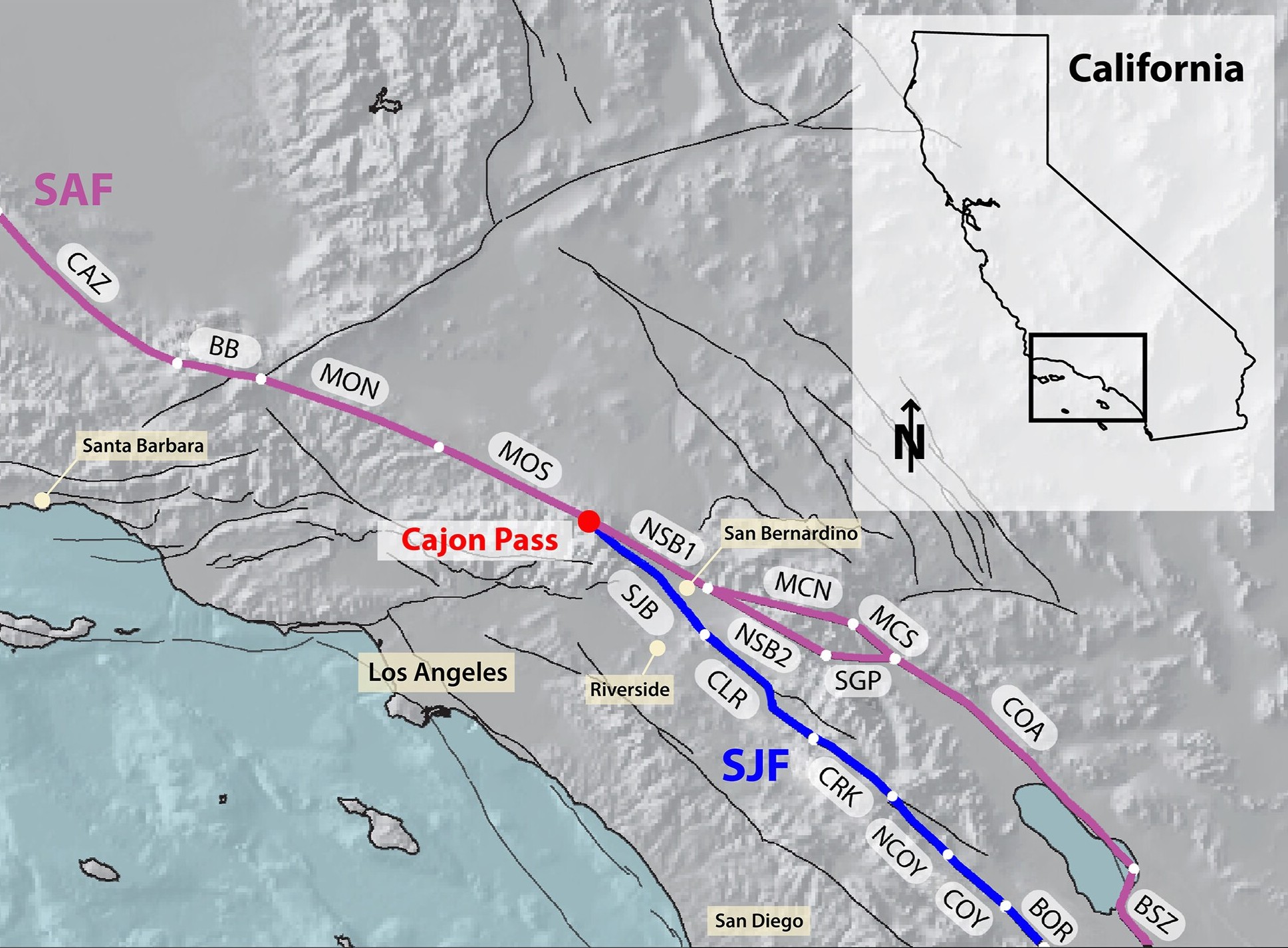
The faults could rupture separately or together, thanks to an "earthquake gate" between them at Cajon Pass, where the San Jacinto fault splits from the main trace of the San Andreas fault. Researchers discovered that Cajon Pass can prevent or facilitate earthquakes moving between the faults, depending on how similar their stress levels are at the time of rupture.

And right now, the San Andreas and San Jacinto faults appear to have comparable, extremely elevated stress levels, potentially spelling trouble for Los Angeles, San Bernardino, Riverside and the Coachella Valley, the team warned.

Map of Southern California showing the San Andreas and San Jacinto fault systems. The faults connect at Cajon Pass and run parallel to each other.

Cajon Pass, where the San Andreas and San Jacinto faults connect, is an "earthquake gate" that can facilitate the spread of ruptures. (Image credit: Burkhard et al., 2026. JCR Solid Earth. (CC BY 4.0))

"Our results show that stress levels on multiple fault segments are now at or above the highest values seen in the past millennium and that the region may be capable of a large through-going rupture involving both fault systems," study first author Liliane Burkhard, a planetary geologist at the University of Bern in Switzerland and at the University of Hawaii at Manoa, said in a statement.

The San Andreas and San Jacinto faults have caused 36 earthquakes with magnitudes of 6.4 or above in the past 1,000 years. Southern California's last "big one" was a magnitude 7.9 event in 1857, when a 205-mile (330 kilometers) segment of the San Andreas fault slipped horizontally between Parkfield and Cajon Pass. That rupture did not propagate through Cajon Pass, but a similar megaquake in 1812 did, suggesting this could happen again in what is now a much more built-up and densely populated environment, according to the study.

Almost 170 years have passed since the 1857 megaquake, raising fears that another huge earthquake could be due to hit soon.

To estimate this risk, Burkhard and her colleagues built a model replicating the last 1,000 years of major earthquake activity along the southern San Andreas and San Jacinto fault systems.

The researchers used observations such as tree-ring records and age data from sediments that have been displaced to reconstruct Southern California's earthquake history. They fed this information into the model, which simulated the accumulation, release and propagation of tectonic stress in the San Andreas and San Jacinto faults.

The results, published June 3 in the Journal of Geophysical Research: Solid Earth, suggest the San Andreas and San Jacinto faults are primed for an Earth-shattering rupture, which may involve the earthquake gate at Cajon Pass opening to unleash more destruction than a single-fault event would on its own.

If a rupture were to occur along the two branches of the San Andreas fault that connect at Cajon Pass, it would be a joint rupture, according to the study. If both branches of the San Andreas fault and the San Jacinto fault were involved, this would constitute a tripartite rupture.

The chance of each event happening and the timing of a potential rupture are unknown, but understanding how much stress is building up inside the system could help planners and policymakers prepare for whatever comes next, Burkhard said.

"What we can say is that the system is critically stressed, and that physics-based models like this one give us a clearer picture of the range of scenarios we should be prepared for," she said. "That information matters for hazard assessment, infrastructure planning, and emergency preparedness."

The researchers say their model could apply to other fault junctions and be used as a tool for hazard assessment globally. "We are using rigorous, quantitative science to better understand the risk facing millions of people," Burkhard said.

Indonesia's near-identical, 'Twin Peaks' volcanoes form striking mirror image — Earth from space

16 June 2026 at 14:39
QUICK FACTS

Where is it? Central Java, Indonesia [-7.34485373, 110.02748950]

What's in the photo? Mount Sundoro (left) and Mount Sumbing (right)

Who took the photo? An unnamed astronaut on board the International Space Station

When was it taken? May 10, 2021

This awesome astronaut photo shows the striking symmetry of "twin" stratovolcanoes at the heart of Java, Indonesia. The parallel peaks are an eye-catching reminder of the region's extreme tectonic activity.

Mount Sundoro (also known as Sindoro or Sindara) on the left of the image, reaches a maximum height of 10,331 feet (3,149 meters). Its partner, Mount Sumbing, sits to the southeast (on the right of the image) and is slightly taller, at 11,056 feet (3,370 m) above sea level.

Both are considered active. Although Sumbing has not erupted since 1730, Sundoro has blown its top more recently, in 1971, and has experienced seismic activity as recently as 2012, according to the Smithsonian Institution's Global Volcanism Program.

The volcanoes' peaks are just 7.5 miles (12 kilometers) apart. A raised ridge with a major highway runs perpendicularly between them.

Each volcano also has a smaller, secondary cone on its flank left over from previous eruptions (to the upper left of Sundoro and the upper right of Sumbing in the image), and their orientations make the volcanoes look like mirror images of each other.

An aerial photograph showing Sundoro and Sumbing side-by-side with near-identical profiles

The two volcanoes also have strikingly similar profiles when viewed from ground level. (Image credit: Rizky Panuntun via Getty Images)

The slopes of both cones are covered with rings of dark-green forest that sharply terminate at their bases. The volcanic soils surrounding the mountains are excellent for growing crops such as rice, corn, coffee and sugarcane, which has led to the deforestation of their surroundings, according to NASA's Earth Observatory.

This matching coloration accentuates the similarities between the pair, especially when viewed from above.

One of the few differences between Sundoro and Sumbing is that the latter volcano has a sizable crater at its summit, which was carved out by the 1730 eruption. As a result, the larger volcano appears to have a darker point at its top.

The volcanoes are commonly referred to as "twins," due to their near-identical profiles. However, local people often call them "husband and wife," according to a local travel site. In this narrative, Sumbing is considered the husband due to its slight height advantage and "more masculine" profile.

A photo of Mount Sumbing showing farmers using the fields around its base

The land surrounding Mount Sundoro and Mount Sumbing (photographed) is rich with volcanic ash, making it ideal for growing various crops. (Image credit: Wikimedia)

Sundoro and Sumbing are part of the wider Dieng Volcanic Complex, which consists of around 20 volcanic cones stretching across central Java. Indonesia is also positioned along the "Ring of Fire," a roughly horseshoe-shaped arc of volcanoes that runs along a series of tectonic plate boundaries encircling the Pacific Ocean.

Over the past few years, there have been a number of significant eruptions in Indonesia, including a pair of violent blasts at Mount Lewotobi Laki-laki, on Flores Island, in 2024 and 2025. As of June 2026, there are seven ongoing eruptions in Indonesia — the most of any nation.

An astronaut photo of the massifRocky rings wear a 'magma hat'

A 2025 astronaut photo shows a massif made of concentric mountain ridges in the Libyan desert. The rocky walls contain ancient artworks.

An astronaut photo of three dark mesas, partially surrounded by orange sand dunesTrio of black mesas in Sahara

A 2023 astronaut photo shows three dark hills, or mesas, towering above southern Mauritania. The structures are remnants of a single Paleozoic-era formation.

An astronaut photo of a volcanic caldera with a skull like shapeGlowering 'skull' in volcanic pit

A 2023 astronaut photo shows off an unusual cranium-like structure appearing to stare up into space from the floor of a large volcanic caldera in Chad.

NASA Flights Map Tropical Ecosystems, Water, Ice

15 June 2026 at 20:24

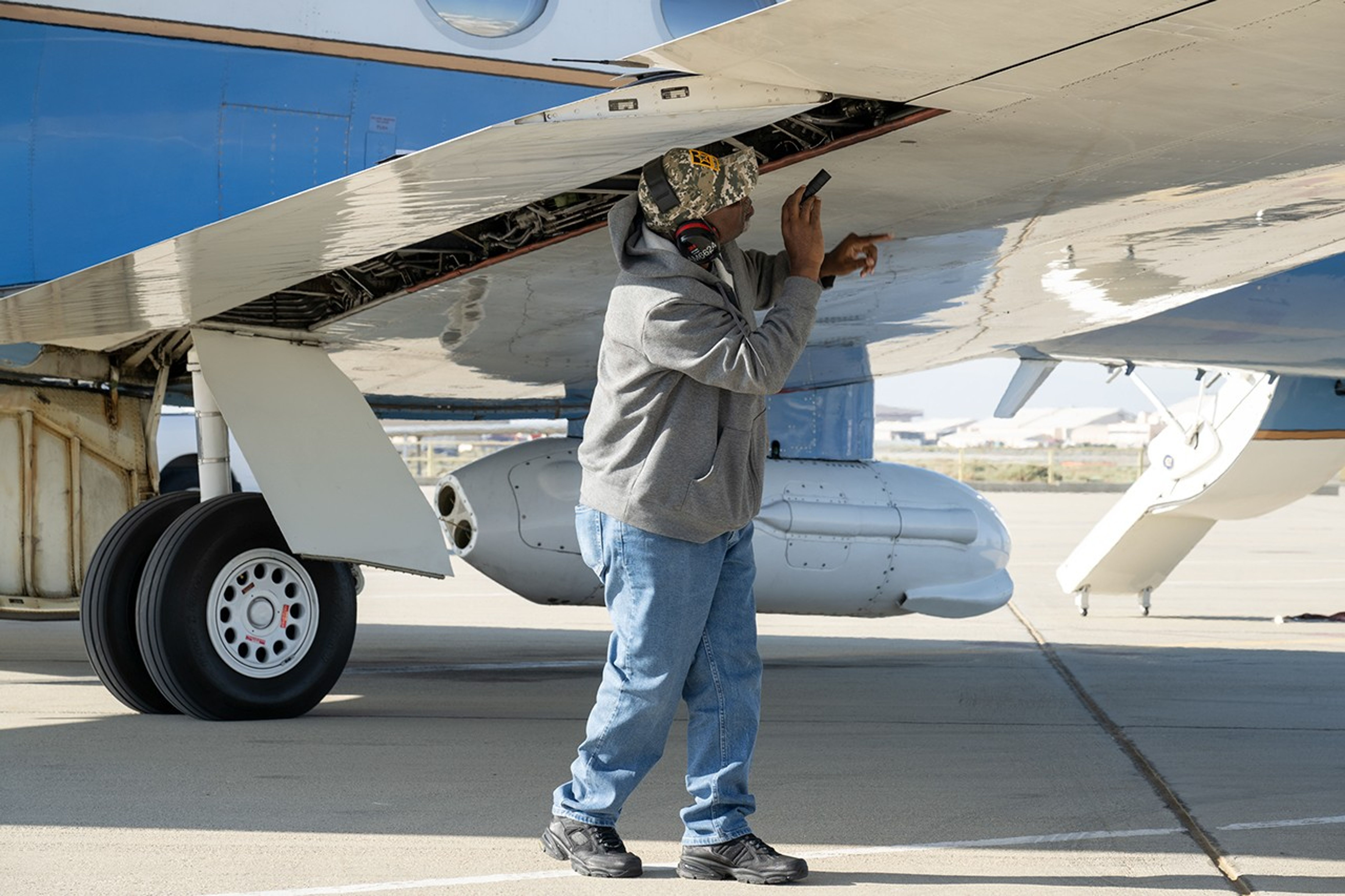
A man uses a flashlight to inspect an aircraft’s wing as part of the preflight checks.
Alvin Mitchell, a NASA C-20A aircraft quality assurance inspector, completes preflight checks at NASA’s Armstrong Flight Research Center in Edwards, California, on April 29 for a mission over Central California. On May 2, the aircraft departed for the Tropical Synthetic Aperture Radar campaign carrying NASA’s Uninhabited Aerial Vehicle Synthetic Aperture Radar.
NASA/Ryan Kline

Data from a NASA campaign in Panama and Peru will help communities prepare for tropical floods in cloud-covered areas, improve scientific understanding of forest health, and support planning for spaceborne missions.

NASA’s C-20A aircraft from Armstrong Flight Research Center in Edwards, California, flew the Uninhabited Aerial Vehicle Synthetic Aperture Radar (UAVSAR) instrument, developed at NASA’s Jet Propulsion Laboratory in Southern California, to gather mission data. While flying repeat paths, the instrument collected high-resolution radar data from a pod mounted beneath the aircraft. The monthlong campaign, known as Tropical Synthetic Aperture Radar, or TropiSAR, concluded on June 4 after 17 flights totaling 75 hours.

Airborne data were captured over Peru in the same times and locations as data captured by the NISAR (NASA-ISRO Synthetic Aperture Radar) satellite to validate key NISAR capabilities and support calibration of the satellite’s L-band radar system. The science validation targeted two measurements: tropical rainforest flood extent within the Pacaya-Samiria National Reserve in Peru, one of the world’s largest protected flooded forests, and glacier movement in the Huascarán National Park in the Peruvian Andes, which is home to the largest concentration of tropical glaciers. The mission also gathered detailed 3D views of tree height and density to estimate biomass, assess forest health, and better understand how forest ecosystems store and release carbon.

In Panama, TropiSAR also supported NASA’s Airborne Validation Unified Experiment: Land and Ocean (AVUELO) campaign in collaboration with the Smithsonian Tropical Research Institute. Airborne radar data were collected from dry forests and coastal wetlands with the goal of better understanding Panama’s rich biodiversity. By linking field measurements with airborne and satellite observations, AVUELO may advance new methods for studying the tropics.

~Jay Levine

The post NASA Flights Map Tropical Ecosystems, Water, Ice appeared first on NASA Science.

San Francisco’s Patchwork Streets

15 June 2026 at 15:30
A view of downtown San Francisco from the International Space Station. The city's streets are visible in the daylight, as well as the Golden Gate Bridge to the north and the San Francisco-Oakland Bay Bridge connecting to Oakland to the east.
A period of unsettled weather brought scattered showers and thunderstorms to California’s Bay Area on May 27, 2026. That afternoon, a break in the clouds left downtown San Francisco and nearby communities beneath mostly cloud-free skies, allowing an astronaut aboard the International Space Station to take this photograph.
NASA

An astronaut aboard the International Space Station took this picture of downtown San Francisco and nearby communities on May 27, 2026. The image captures two of the region’s iconic bridges. The Golden Gate Bridge connects the northern San Francisco Peninsula with Marin County to the north, while the San Francisco-Oakland Bay Bridge spans the bay toward Oakland to the east.  

Read more about this photograph on Earth Observatory.

Text credit: Kathryn Hansen

Image credit: NASA

The post San Francisco’s Patchwork Streets appeared first on NASA Science.

San Francisco’s Patchwork Streets

15 June 2026 at 15:30
A view of downtown San Francisco from the International Space Station. The city's streets are visible in the daylight, as well as the Golden Gate Bridge to the north and the San Francisco-Oakland Bay Bridge connecting to Oakland to the east.
A period of unsettled weather brought scattered showers and thunderstorms to California’s Bay Area on May 27, 2026. That afternoon, a break in the clouds left downtown San Francisco and nearby communities beneath mostly cloud-free skies, allowing an astronaut aboard the International Space Station to take this photograph.
NASA

An astronaut aboard the International Space Station took this picture of downtown San Francisco and nearby communities on May 27, 2026. The image captures two of the region’s iconic bridges. The Golden Gate Bridge connects the northern San Francisco Peninsula with Marin County to the north, while the San Francisco-Oakland Bay Bridge spans the bay toward Oakland to the east.  

Read more about this photograph on Earth Observatory.

Text credit: Kathryn Hansen

Image credit: NASA

Do Distant Light Emissions Prove a Finite One-Way Speed of Light?

13 June 2026 at 06:04
Does the fact that we see light from very distant galaxies prove that the one-way speed of light is finite? Dr. Jason Lisle responds to this question. The conventionality thesis plays a critical role in understanding the issue, suggesting that measurements usually assume an isotropic light speed.

NASA-Funded Research Follows Bird Flight; Birds Follow Their Noses

12 June 2026 at 19:44

A person wearing a helmet with lights on the front holds a small black bird in his palm.
Lead researcher Federico De Pascalis of the Italian Institute for Environmental Protection and Research (ISPRA) holds a Mediterranean storm petrel.
A. Benvenuti

You might think birds skimming over the ocean wouldn’t seek wind unless it was pushing them in the right direction, but NASA-funded researchers have learned that storm petrels find stiff crosswinds worth the slowdown, in return for the clues and cues the gusts carry.

In a paper published by the Royal Society’s Biology Letters May 13, researchers from Woods Hole Oceanographic Institution (WHOI) and the Italian Institute for Environmental Protection and Research (ISPRA) found that Mediterranean storm petrels actively sought out crosswinds, which carried odors the birds used to navigate toward prey. The birds were effectively trading the extra energy needed to fly in a crosswind for the information it blows toward them.

These sparrow-sized birds routinely undertake foraging trips hundreds of miles over the sea, returning to the breeding colony to relieve their partners from incubation duties. Until recently, their small size has precluded researchers’ ability to tag them, keeping their journeys a mystery. In 2020 and 2021, working on the Italian island Sardinia, the team, led by ISPRA and WHOI, attached lightweight GPS sensors to the birds, adding just 3.3% of the birds’ weight as they set out over the Mediterranean Sea.

This finding could help reveal how changing winds might impact seabirds’ feeding, breeding, energy levels, and survival, adding insights about patterns of nutrients in the sea — and the forces that create them.

~Karen Romano Young

The post NASA-Funded Research Follows Bird Flight; Birds Follow Their Noses appeared first on NASA Science.

NASA Spots Giant Ocean Swell Signaling a Potential El Niño Comeback

Earth Experiencing Extreme High TemperaturesSentinel-6 satellite data shows strengthening warm-water waves in the Pacific, pointing to the likely arrival of El Niño and its global weather impacts later in 2026. Several months before an El Niño develops, large waves of warmer, elevated water travel eastward across the Pacific Ocean. Satellite observations in 2026 have detected several of these waves. [...]

The “Impossible” Earthquake Beneath Utah Was Real After All

12 June 2026 at 11:26
Earth Structure Layers Crust Mantle CoreScientists have confirmed a rare “impossible” earthquake deep beneath Utah, revealing a hidden source of seismic activity inside Earth’s mantle. Nearly five decades after a puzzling earthquake struck deep beneath northern Utah, scientists have confirmed that the event was real and part of a rare category of earthquakes that occur much deeper underground than researchers [...]

NASA, USGS Scientists Go Rock Hounding in California’s High Desert

11 June 2026 at 16:38
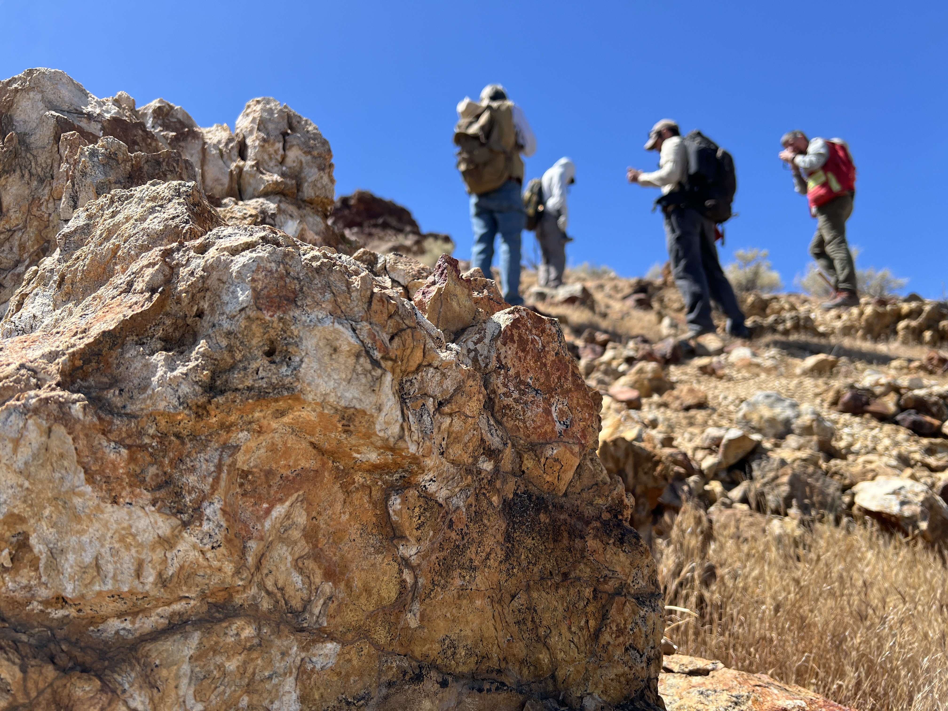
Four people with backpacks pause to examine rocks on a hillside under a clear blue sky, with a large orange-and-tan boulder in the foreground.
Geologists recently converged on a site near Barstow, California, to ground-truth a mineral discovery made on public land by a NASA JPL sensor flying aboard a plane overhead.
NASA/JPL-Caltech

Equipped with rock picks and hand lenses, a team of geoscientists deployed to the Mojave Desert recently to investigate a tantalizing “fingerprint” detected by a NASA sensor. Their target: a cache of topaz hiding in plain sight.

The geologists weren’t searching for gem-grade treasure. Rather, the presence of topaz could hint at a more valuable deposit below of something known as porphyry copper.

One of the world’s primary sources of copper, these deposits are left behind when magma and hot water from deep underground course through Earth’s crust, chemically transforming the surrounding rock. This tends to occur where one tectonic plate dives below another, known as a subduction zone, such as the North American Cordillera, which stretches from the Canadian Rockies to western Mexico.

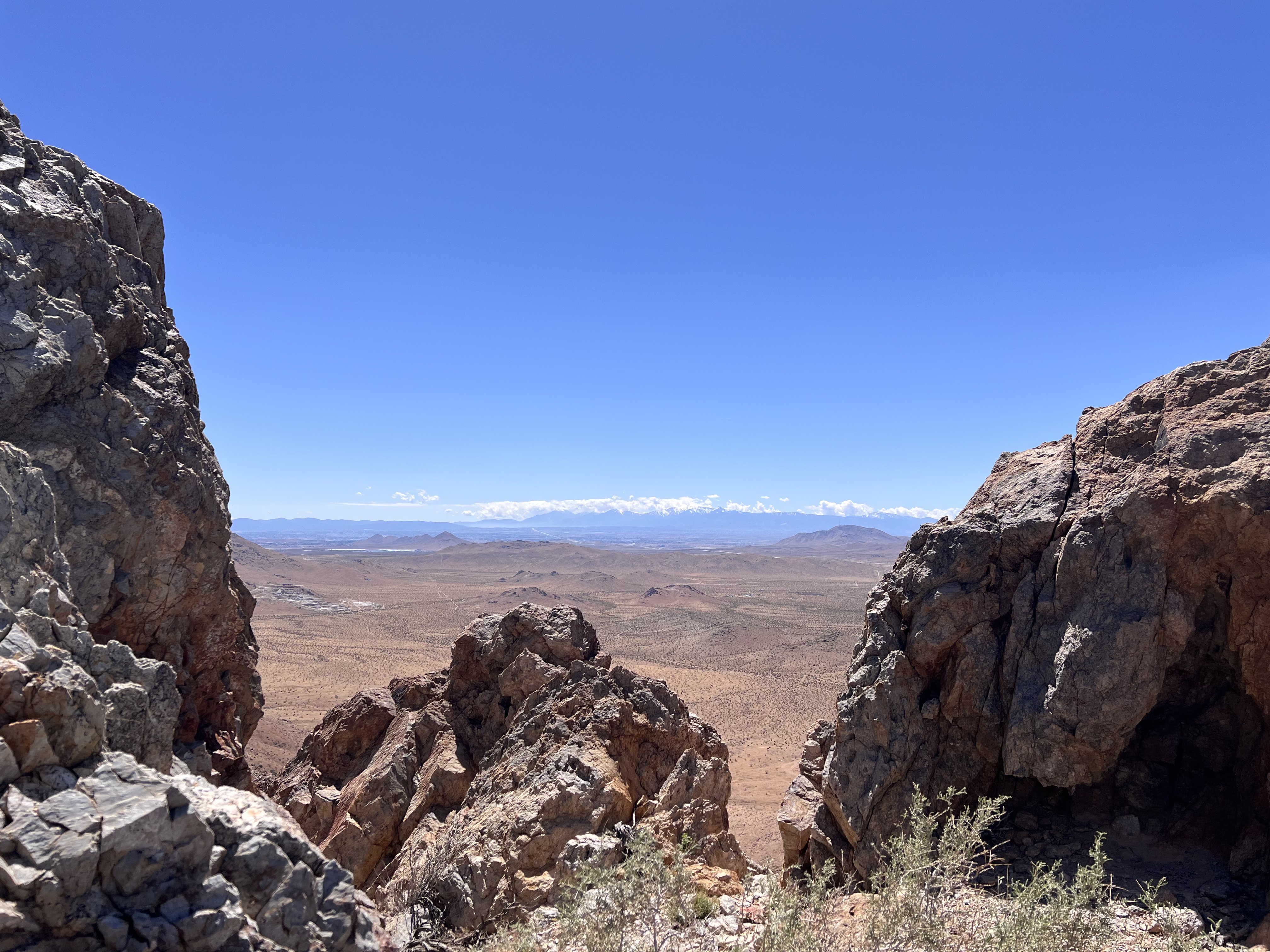
A wide-angle shot framing a vast desert plain viewed through a natural gap between jagged rock formations in the foreground. Distant snowcapped hills stretch across the far horizon beneath a thin line of cloud.
California’s high desert stretches below a bright spring sky in April 2026. NASA and USGS scientists are using airborne remote sensing to home in on potential sources of critical minerals here and across the Western U.S.
NASA/JPL-Caltech

In addition to copper — the third most used metal in the world after steel and aluminum — the deposits can hold other critical minerals like molybdenum and tellurium, which are used in everything from steelmaking to solar panels. Finding the deposits isn’t easy. Geologists look for topaz because it forms under the same volcanic conditions.

For the team in the Mojave, the goal was to collect more evidence. That would require boots on the ground and a heavy bag of samples. The scientists who converged on the site included three experts from the U.S. Geological Survey (USGS) and Robert Green of NASA’s Jet Propulsion Laboratory in Southern California.

“What we’re doing out here is geologic CSI,” said Green, referring to the investigative TV show, as he split open a weathered red rock to expose a sparkling core. “We’re looking for clues to reconstruct what happened here.”

A three-dimensional cube representing multispectral imaging data of an arid landscape. The front face shows an aerial image. The top and side panels display colored bands ranging from blue to red, illustrating spectral information for each pixel.
Three-dimensional image cubes illustrate the volume of data captured by NASA imaging spectrometers. The front face shows an aerial view of the Mojave Desert. The colorful side panels reveal what no eye or camera can detect: the spectral fingerprints of minerals present in every pixel.
NASA/JPL-Caltech

Next-generation mineral mapping

The sensor that detected the topaz deposit on public land near Barstow, California, was built at JPL. Called AVIRIS, short for Airborne Visible Infrared Imaging Spectrometer, it analyzes reflected sunlight and can be used to identify chemicals and minerals by their unique spectral fingerprint. The technology was pioneered in the early 1980s by a team that included Green, and space-hardened versions have explored the Moon, Mars, and other rocky bodies in the solar system in the decades since.

While its cousins study distant worlds aboard spacecraft, the AVIRIS line of sensors is advancing Earth science from aircraft. The latest model, AVIRIS-5, recently took to the skies for the first time as part of the NASA-USGS Geologic Earth Mapping Experiment (GEMx). The goal of GEMx is to identify sources of critical minerals across the American West, including in the waste rock of active and legacy mines. It is led by the USGS as part of its larger, nationwide initiative.

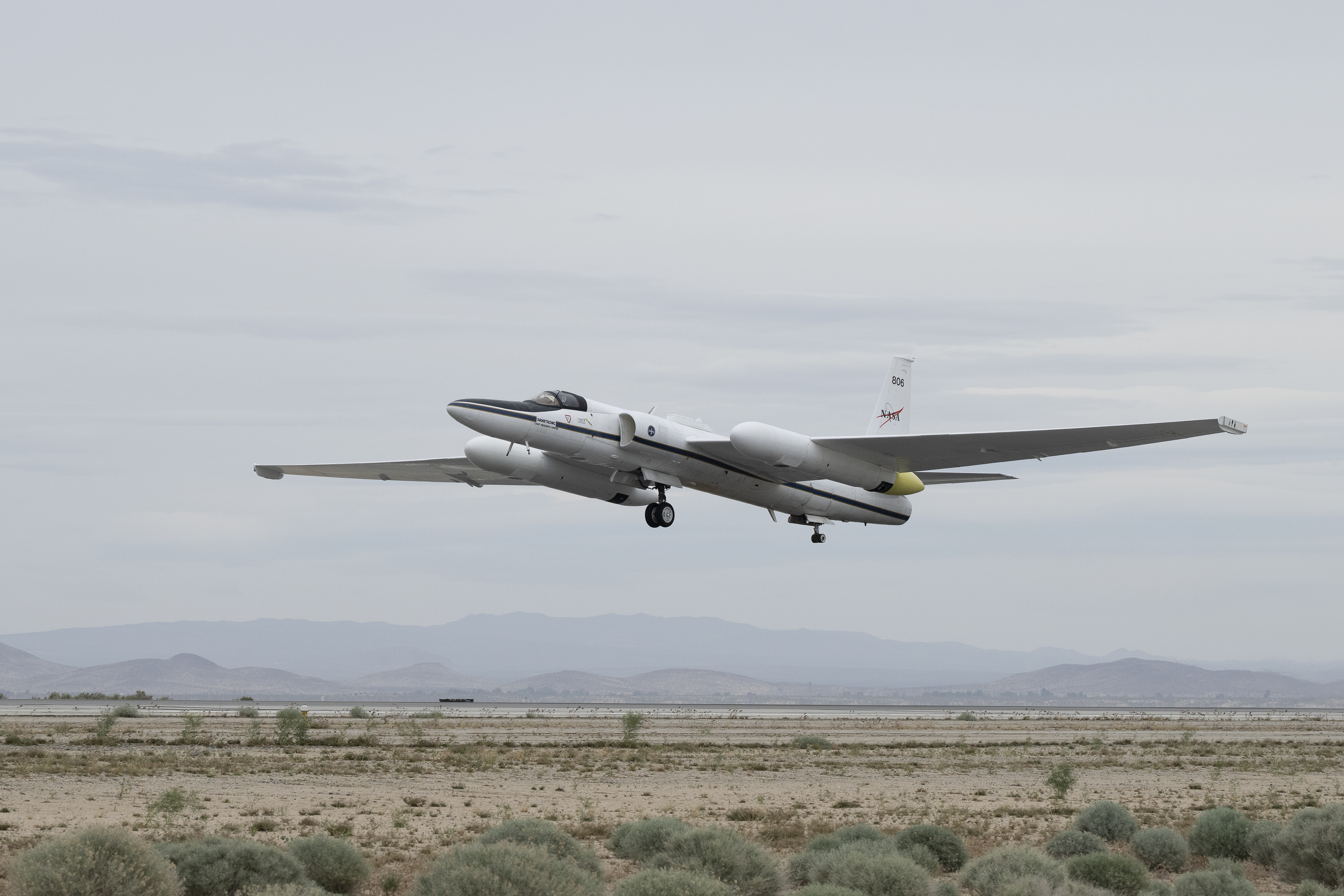
Carrying next-generation sensors, a high-altitude NASA ER-2 aircraft takes off from the agency’s Armstrong Flight Research Center in Edwards, California, on March 31, 2026, to support the GEMx mineral mapping campaign.
NASA/Carla Thomas

Since 2023, GEMx flights have covered more than 386,000 square miles (1 million square kilometers) of American soil, including most of California.

Ground-truthing the sensor data can entail hot field work, scrambling over steep crags to uncover samples for lab analysis. While testing has confirmed the topaz discovery, determining if the Mojave site overlies a porphyry copper deposit will require intensive investigation using ground-penetrating equipment. But the AVIRIS finding shows how advanced NASA airborne sensing can help lead geologists to the metaphorical needle in a haystack, even in heavily explored Southern California.

“People have been prospecting this area for generations,” said Erik Tharalson, a USGS geologist. “But there’s a lot more to discover.”

High flyer

From the beginning, the GEMx mineral mapping campaign has been enabled by one of the highest-flying aircraft in NASA’s fleet: the ER‑2. It deployed on March 31 from NASA’s Armstrong Flight Research Center in Edwards, California, to Colorado Springs Airport in Colorado.

“We deployed to Colorado Springs to maximize flight time for data collection needed in Colorado, Utah, New Mexico, Arizona, and Texas,” said John McGrath, ER‑2 project manager at NASA Armstrong.

By the conclusion of this deployment on June 5, the aircraft had completed 26 flights totaling more than 125 hours. Soaring at about 65,000 feet, the ER-2 can fly at high altitudes that allow it to collect broad‑area, high‑resolution spectral measurements in a single pass, supporting researchers studying mineral composition and surface processes.

In 2025, the aircraft flew 36 science missions, collecting more than 7 billion measurements over 200 flight hours. The data has contributed to the largest airborne surface mineralogy dataset gathered in a single NASA-USGS campaign.

The GEMx survey is led and funded by the USGS Earth Mapping Resources Initiative. Earth MRI is modernizing mapping the nation’s surface and subsurface to find new, critical, and other minerals. It is a partnership effort with 45 state geological surveys, federal agencies, private industry, tribes, universities, and others. The initiative will capitalize on both the technology developed by NASA for spectroscopic imaging, as well as the USGS expertise in analyzing the datasets, conducting field work, and deriving critical mineral information from them.

To learn more about GEMx visit:

https://science.nasa.gov/mission/gemx/

Media Contacts

Andrew Wang / Andrew Good
Jet Propulsion Laboratory, Pasadena, Calif.
626-379-6874 / 818-393-2433
andrew.wang@jpl.nasa.gov / andrew.c.good@jpl.nasa.gov

Written by Sally Younger

2026-037

The post NASA, USGS Scientists Go Rock Hounding in California’s High Desert appeared first on NASA Science.

NASA, USGS Scientists Go Rock Hounding in California’s High Desert

11 June 2026 at 16:38
Four people with backpacks pause to examine rocks on a hillside under a clear blue sky, with a large orange-and-tan boulder in the foreground.
Geologists recently converged on a site near Barstow, California, to ground-truth a mineral discovery made on public land by a NASA JPL sensor flying aboard a plane overhead.
NASA/JPL-Caltech

Equipped with rock picks and hand lenses, a team of geoscientists deployed to the Mojave Desert recently to investigate a tantalizing “fingerprint” detected by a NASA sensor. Their target: a cache of topaz hiding in plain sight.

The geologists weren’t searching for gem-grade treasure. Rather, the presence of topaz could hint at a more valuable deposit below of something known as porphyry copper.

One of the world’s primary sources of copper, these deposits are left behind when magma and hot water from deep underground course through Earth’s crust, chemically transforming the surrounding rock. This tends to occur where one tectonic plate dives below another, known as a subduction zone, such as the North American Cordillera, which stretches from the Canadian Rockies to western Mexico.

A wide-angle shot framing a vast desert plain viewed through a natural gap between jagged rock formations in the foreground. Distant snowcapped hills stretch across the far horizon beneath a thin line of cloud.
California’s high desert stretches below a bright spring sky in April 2026. NASA and USGS scientists are using airborne remote sensing to home in on potential sources of critical minerals here and across the Western U.S.
NASA/JPL-Caltech

In addition to copper — the third most used metal in the world after steel and aluminum — the deposits can hold other critical minerals like molybdenum and tellurium, which are used in everything from steelmaking to solar panels. Finding the deposits isn’t easy. Geologists look for topaz because it forms under the same volcanic conditions.

For the team in the Mojave, the goal was to collect more evidence. That would require boots on the ground and a heavy bag of samples. The scientists who converged on the site included three experts from the U.S. Geological Survey (USGS) and Robert Green of NASA’s Jet Propulsion Laboratory in Southern California.

“What we’re doing out here is geologic CSI,” said Green, referring to the investigative TV show, as he split open a weathered red rock to expose a sparkling core. “We’re looking for clues to reconstruct what happened here.”

A three-dimensional cube representing multispectral imaging data of an arid landscape. The front face shows an aerial image. The top and side panels display colored bands ranging from blue to red, illustrating spectral information for each pixel.
Three-dimensional image cubes illustrate the volume of data captured by NASA imaging spectrometers. The front face shows an aerial view of the Mojave Desert. The colorful side panels reveal what no eye or camera can detect: the spectral fingerprints of minerals present in every pixel.
NASA/JPL-Caltech

Next-generation mineral mapping

The sensor that detected the topaz deposit on public land near Barstow, California, was built at JPL. Called AVIRIS, short for Airborne Visible Infrared Imaging Spectrometer, it analyzes reflected sunlight and can be used to identify chemicals and minerals by their unique spectral fingerprint. The technology was pioneered in the early 1980s by a team that included Green, and space-hardened versions have explored the Moon, Mars, and other rocky bodies in the solar system in the decades since.

While its cousins study distant worlds aboard spacecraft, the AVIRIS line of sensors is advancing Earth science from aircraft. The latest model, AVIRIS-5, recently took to the skies for the first time as part of the NASA-USGS Geologic Earth Mapping Experiment (GEMx). The goal of GEMx is to identify sources of critical minerals across the American West, including in the waste rock of active and legacy mines. It is led by the USGS as part of its larger, nationwide initiative.

Carrying next-generation sensors, a high-altitude NASA ER-2 aircraft takes off from the agency’s Armstrong Flight Research Center in Edwards, California, on March 31, 2026, to support the GEMx mineral mapping campaign.
NASA/Carla Thomas

Since 2023, GEMx flights have covered more than 386,000 square miles (1 million square kilometers) of American soil, including most of California.

Ground-truthing the sensor data can entail hot field work, scrambling over steep crags to uncover samples for lab analysis. While testing has confirmed the topaz discovery, determining if the Mojave site overlies a porphyry copper deposit will require intensive investigation using ground-penetrating equipment. But the AVIRIS finding shows how advanced NASA airborne sensing can help lead geologists to the metaphorical needle in a haystack, even in heavily explored Southern California.

“People have been prospecting this area for generations,” said Erik Tharalson, a USGS geologist. “But there’s a lot more to discover.”

High flyer

From the beginning, the GEMx mineral mapping campaign has been enabled by one of the highest-flying aircraft in NASA’s fleet: the ER‑2. It deployed on March 31 from NASA’s Armstrong Flight Research Center in Edwards, California, to Colorado Springs Airport in Colorado.

“We deployed to Colorado Springs to maximize flight time for data collection needed in Colorado, Utah, New Mexico, Arizona, and Texas,” said John McGrath, ER‑2 project manager at NASA Armstrong.

By the conclusion of this deployment on June 5, the aircraft had completed 26 flights totaling more than 125 hours. Soaring at about 65,000 feet, the ER-2 can fly at high altitudes that allow it to collect broad‑area, high‑resolution spectral measurements in a single pass, supporting researchers studying mineral composition and surface processes.

In 2025, the aircraft flew 36 science missions, collecting more than 7 billion measurements over 200 flight hours. The data has contributed to the largest airborne surface mineralogy dataset gathered in a single NASA-USGS campaign.

The GEMx survey is led and funded by the USGS Earth Mapping Resources Initiative. Earth MRI is modernizing mapping the nation’s surface and subsurface to find new, critical, and other minerals. It is a partnership effort with 45 state geological surveys, federal agencies, private industry, tribes, universities, and others. The initiative will capitalize on both the technology developed by NASA for spectroscopic imaging, as well as the USGS expertise in analyzing the datasets, conducting field work, and deriving critical mineral information from them.

To learn more about GEMx visit:

https://science.nasa.gov/mission/gemx/

Media Contacts

Andrew Wang / Andrew Good
Jet Propulsion Laboratory, Pasadena, Calif.
626-379-6874 / 818-393-2433
andrew.wang@jpl.nasa.gov / andrew.c.good@jpl.nasa.gov

Written by Sally Younger

2026-037

❌