The Nebraska Sandhills stretch across the north-central part of the state in this image acquired on August 19, 2025, with the OLI (Operational Land Imager) on Landsat 8.
NASA Earth Observatory/Lauren Dauphin
Editor’s Note: Today’s story is the answer to the June Puzzler.
The undulating landscape of north-central Nebraska may be easy to overlook among the iconic dune fields of the world. Far from any coast or desert, the Nebraska Sandhills—comprising the Western Hemisphere’s largest system of sand dunes—bring their own brand of beauty and value. Grasslands blanket the rolling hills, providing grazing grounds for livestock, while lakes and wetlands dot the landscape, supporting diverse plant and animal life.
Much of the sand forming the hills originated in the Rocky Mountains. Rivers carried the eroded material down from the mountains and deposited it across the Great Plains during the Pleistocene. In times of drought, winds blowing predominantly from the north or south lofted sand out of dried riverbeds, gradually building and shaping dunes. About 3,500 years ago, grassland vegetation stabilized the features. Today, the rippled pattern spans about 20,000 square miles (52,000 square kilometers), about one-quarter of the state of Nebraska.
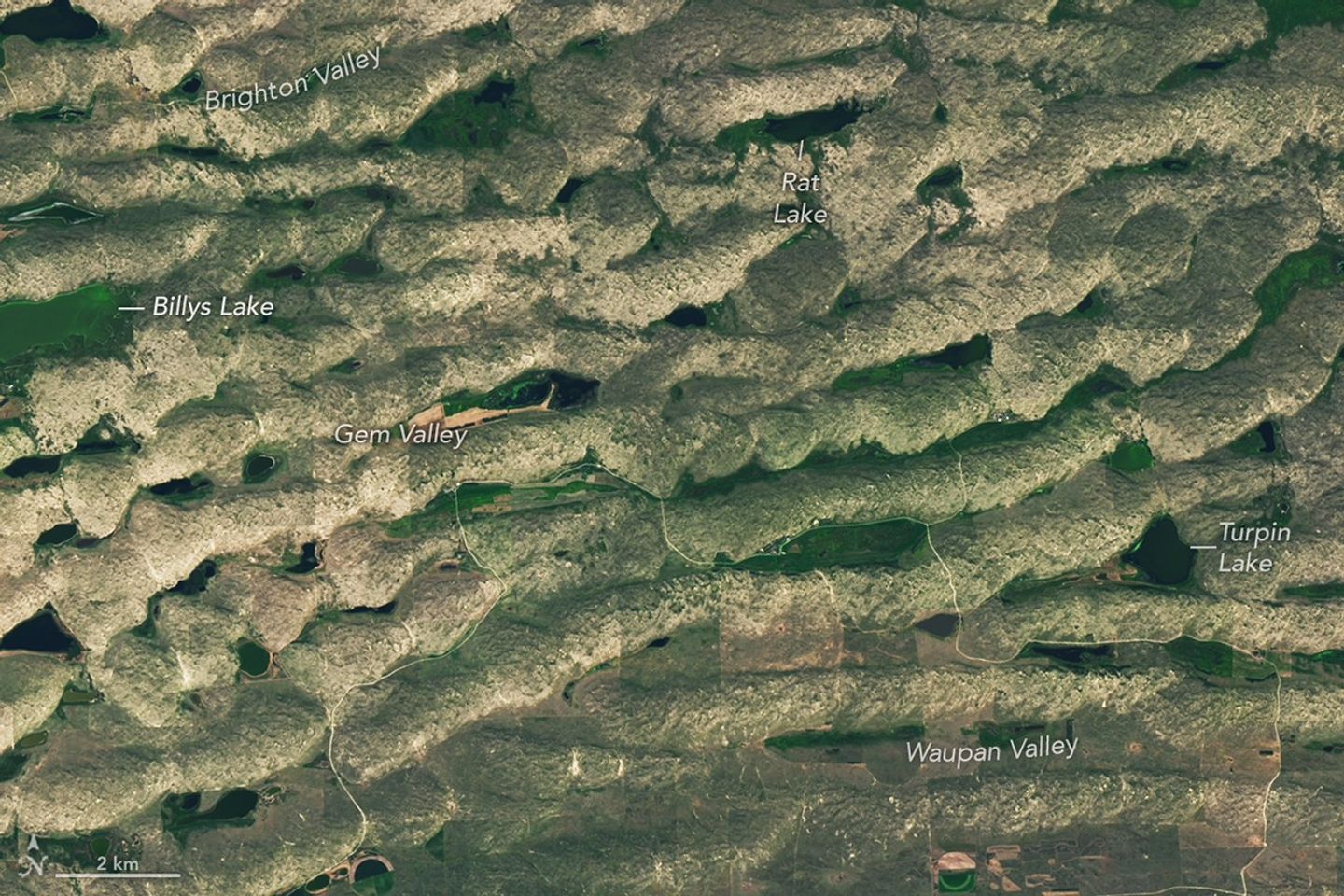
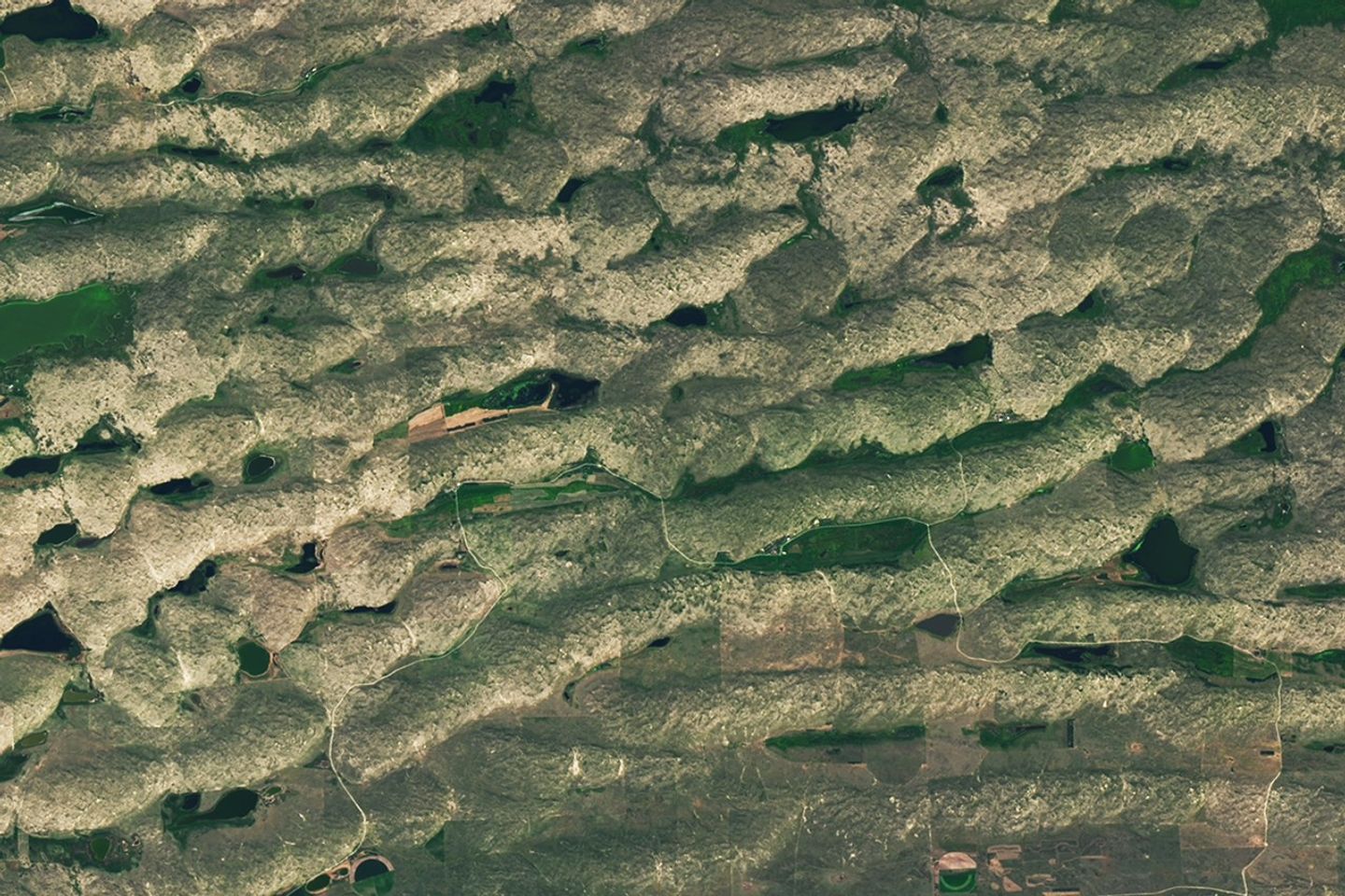
Some of the largest, grassland-covered dunes in the Nebraska Sandhills are found in the northwestern part of the region, shown in this image acquired on August 19, 2025, with the OLI (Operational Land Imager) on Landsat 8.
NASA Earth Observatory/Lauren Dauphin
Some of the largest dunes occur in and around the area shown in the detailed image above, near the northern edge of the Sandhills region. These transverse dunes stand as high as 400 feet (120 meters) and extend for several miles. Their northern slopes are gentler than their southern slopes, reflecting the dominant influence of northerly winds. In other areas, dunes are more symmetric, suggesting that winds blew with nearly equal strength from the north and south, alternating with the seasons.
The grasslands that now cover the hills constitute pastureland for grazing livestock. Ranching expanded significantly in the area after passage of the Kinkaid Act in 1904, which allotted 640-acre parcels of land to ranchers who would settle it. Today, far more cattle than humans occupy the region, and half of Nebraska’s nearly 23 million acres of rangeland and pastureland are in the Sandhills. Some ranchers graze their cattle in patterns meant to approximate the large bison herds that once roamed the land.
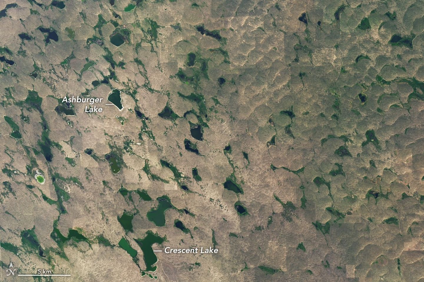
Lakes and wetlands fill the valleys between dunes in Crescent Lake National Wildlife Refuge, shown in this image acquired on August 19, 2025, with the OLI (Operational Land Imager) on Landsat 8.
NASA Earth Observatory/Lauren Dauphin
Though much of the land in the Sandhills is privately owned, some is set aside in protected public lands. One of these areas, Crescent Lake National Wildlife Refuge on the southwestern edge of the Sandhills region, is shown above. Wetlands, including shallow lakes, marshes, and wet meadows, fill some of the valleys between the dunes. The land here is sponge-like, with precipitation seeping down through the soil and recharging groundwater instead of flowing off through stream channels.
Located along the Central Flyway, the refuge is a haven for migratory birds, and dozens of species of waterfowl, marsh birds, and shorebirds utilize the area. Among other wildlife, several types of turtles thrive in the ponds and prairies. Wetlands across the Sandhills support rare species such as the whooping crane, western prairie fringed orchid, and Topeka shiner.
NASA Earth Observatory images by Lauren Dauphin, using Landsat data from the U.S. Geological Survey. Story by Lindsey Doermann.
On May 8, 2026, satellites detected signs of an unexpected submarine volcanic eruption in the Bismarck Sea near the islands of Papua New Guinea. Over the next several weeks, plumes of steam and ash streamed over the sea, and areas of discolored water surrounded the eruption site. Relatively little is known about the ocean floor in this area or the volcanic feature that is presently erupting. But experts think the new activity, ongoing as of mid-June, might be occurring along the Titan Ridge and has the potential to form an ephemeral new island.
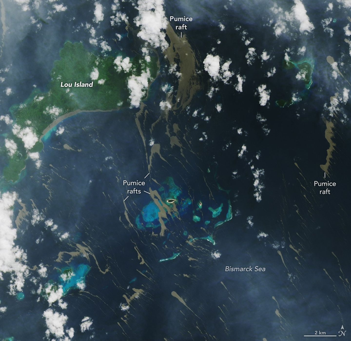
Despite the unknowns, the effects of the eruption became unmistakable for some communities in Papua New Guinea’s Admiralty Islands. In early June, rafts of pumice drifted northwest from the eruption site and clogged up coastlines on several of the islands. Bands of the buoyant volcanic material are visible in this image, acquired with the OLI (Operational Land Imager) on Landsat 8 on June 4, as they drifted with surface currents on the Bismarck Sea.
Several days after the image, news outlets reported acute impacts from thick masses of pumice reaching coastal areas. Communities on Lou Island and Baluan Island, to the south, were described by officials as among the worst affected, according to reports from local media. Outlets reported that a layer of pumice up to several meters thick blanketed the shore, cutting off access to the water. The volcanic fragments similarly choked the coast and key waterways around the much larger Manus Island, about 125 kilometers (80 miles) northwest of the volcano and out of frame.
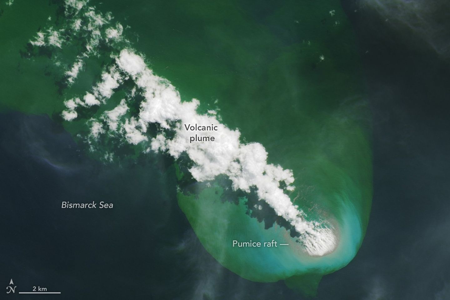
A submarine volcano produces a plume of discolored water and vents steam into the air in an image acquired on June 4, 2026, with the OLI (Operational Land Imager) on Landsat 8. Pumice is visible near the base of the plume and exhibits a thermal signature in infrared imagery.
NASA Earth Observatory/Lauren Dauphin
Studies of past pumice raft events have found that the material can remain afloat for months to years before sinking out of satellite view. Larger rafts can form with the help of ash, which serves to “weld” together fragments of the porous rock, said Jim Garvin, the chief scientist at NASA’s Goddard Space Flight Center, noting this process occurred during the 2022 eruption of Hunga Tonga-Hunga Ha‘apai. “These masses can pile up around erupting vents to protect the eruption centers and produce ephemeral new lands in some cases,” he said. When adrift, such pumice platforms can act as floating homes for marine organisms—from microalgae to bryozoans to barnacles—and enable them to disperse over long distances.
Though beneficial to life in some ways, the rafts can pose serious threats to humans and other species. Some of the larger fragments of pumice stack up to form ridges when they reach the coastlines of islands. Reports from Papua New Guinea highlight the disruptions to fishing, the transport of goods, and access to critical services that can occur when pumice accumulates along the coast.
Communities have expressed concerns over the pumice’s effects on marine ecosystems, as well. Researchers have noted that the sustained presence of pumice can block sunlight and may inhibit photosynthesis in seagrass and corals below, and the rocks may physically damage reef structures. In a review of the ecological effects of pumice reaching Japan’s coast in 2021, researchers noted the die-off of filter-feeding fish in fishery cages from ingesting pumice, warning that other wildlife may be harmed by mistakenly consuming the rocks.
New studies using an ensemble of orbital remote sensing platforms—including Landsat, hyperspectral instruments, and imaging radars—are tracking developments in this Bismarck Sea region, Garvin said. These observations can provide new perspectives on hazards as well as unique scientific opportunities for improved understanding of submarine eruptions.
NASA Earth Observatory images by Lauren Dauphin, using Landsat data from the U.S. Geological Survey. Story by Lindsey Doermann.
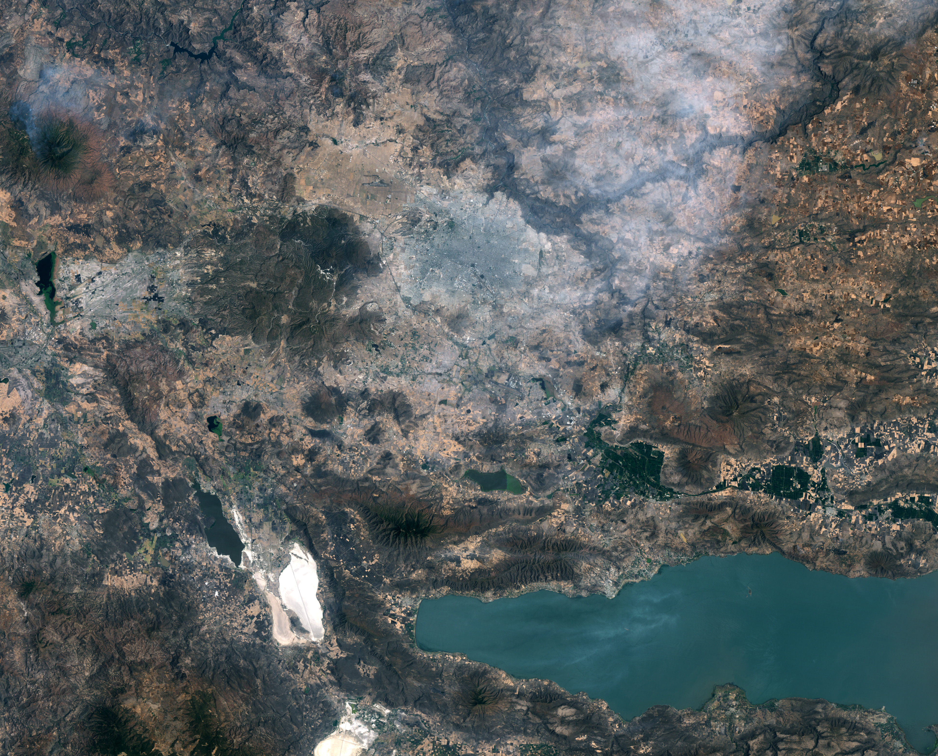
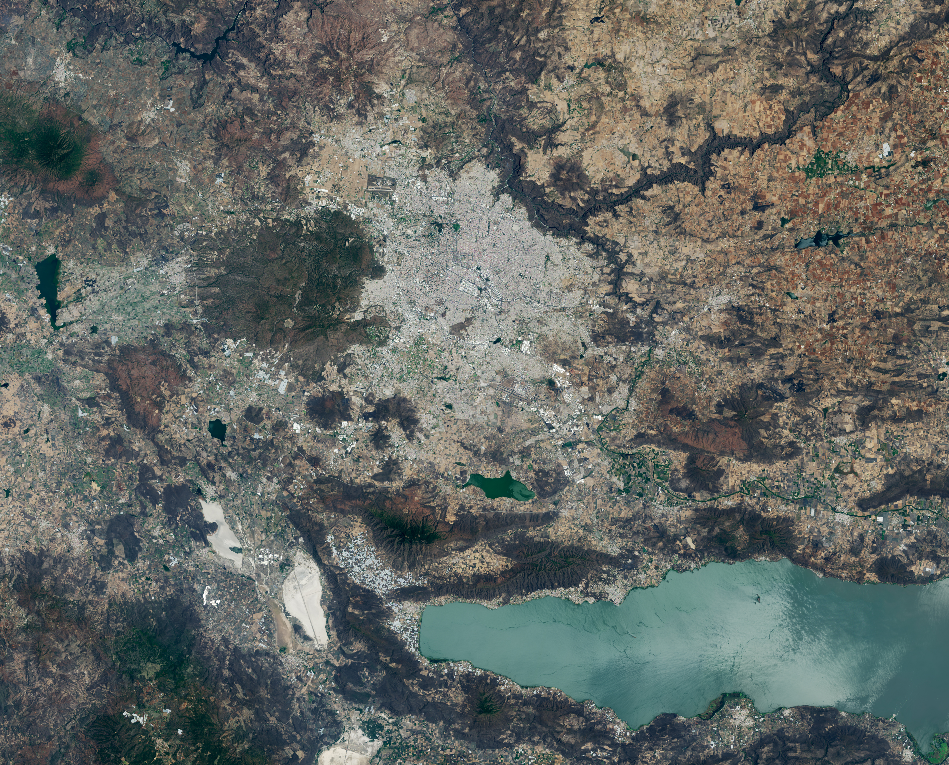
A pair of Landsat images shows 40 years of westward urban expansion from Guadalajara, Mexico. The Thematic Mapper on Landsat 5 captured the left image in 1986; the Operational Land Imager on Landsat 8 captured the right image in 2026.
A pair of Landsat images shows 40 years of westward urban expansion from Guadalajara, Mexico. The Thematic Mapper on Landsat 5 captured the left image in 1986; the Operational Land Imager on Landsat 8 captured the right image in 2026.
NASA Earth Observatory / Lauren Dauphin
A pair of Landsat images shows 40 years of westward urban expansion from Guadalajara, Mexico. The Thematic Mapper on Landsat 5 captured the left image in 1986; the Operational Land Imager on Landsat 8 captured the right image in 2026.
A pair of Landsat images shows 40 years of westward urban expansion from Guadalajara, Mexico. The Thematic Mapper on Landsat 5 captured the left image in 1986; the Operational Land Imager on Landsat 8 captured the right image in 2026.
NASA Earth Observatory / Lauren Dauphin
April 13, 1986
April 27, 2026
April 13, 1986 – April 27, 2026
A pair of Landsat images shows 40 years of westward urban expansion from Guadalajara, Mexico. The TM (Thematic Mapper) on Landsat 5 captured the left image in 1986; the OLI (Operational Land Imager) on Landsat 8 captured the right image in 2026.
Guadalajara, Mexico, was quite a different place when it last hosted World Cup games 40 years ago. The city welcomed matches in June 1986 and did so again in 2026, when South Korea faced Czechia at Guadalajara Stadium in the opening round of the 2026 FIFA World Cup.
In 1986, Guadalajara Stadium had not yet been built in Zapopan, the fast-growing municipality just northwest of Guadalajara. Many of that year’s World Cup matches were held instead at Jalisco Stadium in northeastern Guadalajara. It was in that stadium that France defeated Brazil in a penalty shootout in the 1986 quarterfinals, in what is widely regarded as one of the most memorable World Cup games of all time.
As seen in the Landsat images above, the land where Guadalajara Stadium (also called Estadio Akron) now sits was farmland in 1986. The new stadium, built in 2010 to host Mexico’s Club Deportivo Guadalajara, or Chivas, lies near the Sierra la Primavera volcanic complex, a rugged landscape full of lava flows, volcanic domes, steam vents, and hot springs. The architects who designed the stadium took inspiration from the nearby volcanic terrain, creating a structure that rises from a grassy earthen berm meant to resemble the flanks of a volcano, topped with a white roof reminiscent of a volcanic cloud.
About 95,000 years ago, the volcanic system underneath Sierra la Primavera produced a massive eruption that caused a caldera 11 kilometers (7 miles) in diameter to slump downward. Water filled the depression for tens of thousands of years, but tectonic uplift and the accumulation of sediment eventually led to the demise of the lake. Erosion wore away the softer surrounding rock over time, leaving harder, erosion-resistant volcanic rocks within the circular feature that now stand high above the surrounding terrain.
Starting about 60,000 years ago, several lava domes erupted along the southern edge of the caldera. The youngest of them, Cerro del Colli, formed about 30,000 years ago, leaving the dome-shaped feature just south of the stadium and contributing to a broader landscape dotted with other volcanic domes and cinder cones.
Today, much of the original caldera has been preserved as a forested area known as La Primavera Biosphere Reserve, even as development has partially encircled it during the past 40 years. The population of the Guadalajara metro area has grown from about 2.7 million in 1986 to more than 5.5 million now, with particularly rapid growth in Zapopan, a burgeoning tech hub sometimes billed as “Mexico’s Silicon Valley.” A prominent development visible in Landsat images is Guadalajara Technology Park, one of several new industrial parks in Zapopan. New greenhouses have also come to the area en masse, including south of the reserve, where they are mostly used to grow fruits and vegetables.
World Cup fever runs particularly high in Guadalajara, which is hosting World Cup matches for the third time. During Brazil’s legendary title run in 1970, when Pelé led the team, Jalisco Stadium was the venue for Brazil’s first-round, quarterfinal, and semifinal matches. To commemorate him, the city in May 2026 erected a 9.5-meter (31-foot) bronze statue of the iconic football (soccer) player.
Even the animals at Guadalajara Zoo are taking part in the festivities, with elephants, gorillas, giraffes, capybaras, pumas, and macaws “predicting” match winners by choosing between food, shirts, boxes, soccer balls, and other items. A puma named Muluk predicted South Korea would beat Czechia by sniffing and moving a ball, one newspaper reported.
Guadalajara will host four first-round matches: South Korea vs. Czechia on June 12, Mexico vs. South Korea on June 18, Colombia vs. Democratic Republic of the Congo on June 23, and Uruguay vs. Spain on June 26.
NASA Earth Observatory images by Lauren Dauphin, using Landsat data from the U.S. Geological Survey. Story by Adam Voiland.
A pair of Landsat images shows 40 years of westward urban expansion from Guadalajara, Mexico. The Thematic Mapper on Landsat 5 captured the left image in 1986; the Operational Land Imager on Landsat 8 captured the right image in 2026.
A pair of Landsat images shows 40 years of westward urban expansion from Guadalajara, Mexico. The Thematic Mapper on Landsat 5 captured the left image in 1986; the Operational Land Imager on Landsat 8 captured the right image in 2026.
NASA Earth Observatory / Lauren Dauphin
A pair of Landsat images shows 40 years of westward urban expansion from Guadalajara, Mexico. The Thematic Mapper on Landsat 5 captured the left image in 1986; the Operational Land Imager on Landsat 8 captured the right image in 2026.
A pair of Landsat images shows 40 years of westward urban expansion from Guadalajara, Mexico. The Thematic Mapper on Landsat 5 captured the left image in 1986; the Operational Land Imager on Landsat 8 captured the right image in 2026.
NASA Earth Observatory / Lauren Dauphin
April 13, 1986
April 27, 2026
April 13, 1986 – April 27, 2026
A pair of Landsat images shows 40 years of westward urban expansion from Guadalajara, Mexico. The TM (Thematic Mapper) on Landsat 5 captured the left image in 1986; the OLI (Operational Land Imager) on Landsat 8 captured the right image in 2026.
Guadalajara, Mexico, was quite a different place when it last hosted World Cup games 40 years ago. The city welcomed matches in June 1986 and did so again in 2026, when South Korea faced Czechia at Guadalajara Stadium in the opening round of the 2026 FIFA World Cup.
In 1986, Guadalajara Stadium had not yet been built in Zapopan, the fast-growing municipality just northwest of Guadalajara. Many of that year’s World Cup matches were held instead at Jalisco Stadium in northeastern Guadalajara. It was in that stadium that France defeated Brazil in a penalty shootout in the 1986 quarterfinals, in what is widely regarded as one of the most memorable World Cup games of all time.
As seen in the Landsat images above, the land where Guadalajara Stadium (also called Estadio Akron) now sits was farmland in 1986. The new stadium, built in 2010 to host Mexico’s Club Deportivo Guadalajara, or Chivas, lies near the Sierra la Primavera volcanic complex, a rugged landscape full of lava flows, volcanic domes, steam vents, and hot springs. The architects who designed the stadium took inspiration from the nearby volcanic terrain, creating a structure that rises from a grassy earthen berm meant to resemble the flanks of a volcano, topped with a white roof reminiscent of a volcanic cloud.
About 95,000 years ago, the volcanic system underneath Sierra la Primavera produced a massive eruption that caused a caldera 11 kilometers (7 miles) in diameter to slump downward. Water filled the depression for tens of thousands of years, but tectonic uplift and the accumulation of sediment eventually led to the demise of the lake. Erosion wore away the softer surrounding rock over time, leaving harder, erosion-resistant volcanic rocks within the circular feature that now stand high above the surrounding terrain.
Starting about 60,000 years ago, several lava domes erupted along the southern edge of the caldera. The youngest of them, Cerro del Colli, formed about 30,000 years ago, leaving the dome-shaped feature just south of the stadium and contributing to a broader landscape dotted with other volcanic domes and cinder cones.
Today, much of the original caldera has been preserved as a forested area known as La Primavera Biosphere Reserve, even as development has partially encircled it during the past 40 years. The population of the Guadalajara metro area has grown from about 2.7 million in 1986 to more than 5.5 million now, with particularly rapid growth in Zapopan, a burgeoning tech hub sometimes billed as “Mexico’s Silicon Valley.” A prominent development visible in Landsat images is Guadalajara Technology Park, one of several new industrial parks in Zapopan. New greenhouses have also come to the area en masse, including south of the reserve, where they are mostly used to grow fruits and vegetables.
World Cup fever runs particularly high in Guadalajara, which is hosting World Cup matches for the third time. During Brazil’s legendary title run in 1970, when Pelé led the team, Jalisco Stadium was the venue for Brazil’s first-round, quarterfinal, and semifinal matches. To commemorate him, the city in May 2026 erected a 9.5-meter (31-foot) bronze statue of the iconic football (soccer) player.
Even the animals at Guadalajara Zoo are taking part in the festivities, with elephants, gorillas, giraffes, capybaras, pumas, and macaws “predicting” match winners by choosing between food, shirts, boxes, soccer balls, and other items. A puma named Muluk predicted South Korea would beat Czechia by sniffing and moving a ball, one newspaper reported.
Guadalajara will host four first-round matches: South Korea vs. Czechia on June 12, Mexico vs. South Korea on June 18, Colombia vs. Democratic Republic of the Congo on June 23, and Uruguay vs. Spain on June 26.
NASA Earth Observatory images by Lauren Dauphin, using Landsat data from the U.S. Geological Survey. Story by Adam Voiland.
TEMPO detected high concentrations of nitrogen dioxide during the morning commute at 7:05 a.m. local time on May 18, 2026 (left), along the New York-Washington corridor. The instrument detected lower levels of the gas at 3:05 p.m. (right), after chemical reactions involving nitrogen dioxide had contributed to elevated ozone concentrations in the afternoon.
NASA Earth Observatory/Michala Garrison
7:05 am
3:05 pm
TEMPO detected high concentrations of nitrogen dioxide during the morning commute at 7:05 a.m. local time on May 18, 2026 (left), along the New York-Washington corridor.The instrument detected lower levels of the gas at 3:05 p.m. EDT (right), after chemical reactions involving nitrogen dioxide had contributed to elevated ozone concentrations in the afternoon. NASA Earth Observatory images by Michala Garrison.
More than 35 million people live along the New York–Washington corridor and breathe the region’s air. While air quality has improved significantly in recent decades, outbreaks of ground-level ozone remain common, particularly in the warm summer months, when the chemical reactions that produce the pollutant accelerate and stagnant air allows ozone to accumulate.
A reminder of this seasonal phenomenon came earlier than usual in 2026, when a mid-May heat wave prompted the New York State Department of Health and the New York Department of Environmental Conservation to issue a health advisory on May 17 over concerns about ozone. The code orange advisory warned young people, older adults, and those working or exercising outdoors to limit activity due to ozone’s respiratory and cardiovascular health impacts.
As expected, ground-based air-quality sensors operated by state and federal agencies showed ozone reaching unhealthy levels for sensitive groups on May 18, something that typically happens several times per year. Meanwhile, NASA’s TEMPO (Tropospheric Emissions: Monitoring of Pollution) instrument observed the event from geostationary orbit 22,000 miles (35,000 kilometers) above the equator, a unique vantage point that allows the sensor to collect frequent observations of air pollution.
TEMPO detects nitrogen dioxide (NO2), a gas emitted by burning fuels, particularly by motor vehicles, that contributes to ozone formation. “There’s often a clear and interesting pattern in TEMPO’s nitrogen dioxide data during ozone alert days,” said Hazem Mahmoud, an atmospheric scientist at NASA’s Atmospheric Science Data Center at Langley Research Center. “We see high concentrations of nitrogen dioxide during the early morning commute that drop off sharply in the late afternoon as ozone increases.”
The decline occurs as sunlight fuels photochemical reactions involving nitrogen dioxide, volatile organic compounds, and oxygen that lead to ozone formation. By late afternoon, these reactions deplete much of the available nitrogen dioxide, slowing ozone production until the cycle begins again the next day.
The pair of images above underscores the pattern. The image on the left was acquired at 7:05 a.m. local time when nitrogen dioxide concentrations were high during the morning commute. By 3:05 p.m. (right), most of the nitrogen dioxide had declined substantially, and surface ozone levels were elevated (below). Meanwhile, afternoon sea breezes appear to have transported the remaining nitrogen dioxide slightly to the west. Note that the data shown is provisional, and processing methods are still being refined.
Sensors on earlier polar-orbiting satellites, such as OMI (Ozone Monitoring Instrument) and TROPOMI (Tropospheric Monitoring Instrument), sampled nitrogen dioxide over New York once per day. After its launch in 2023, TEMPO began providing data every hour, allowing researchers to track the evolution and dispersion of air pollution at much finer time scales.
“TEMPO is helping fill data gaps between ground stations and allowing us to ask new questions,” Mahmoud said. The mission provides data that can improve not only air quality forecasts during crisis situations, such as wildfires, but also the atmospheric models used to forecast the daily rhythms of urban pollution. Such models help researchers understand how natural factors such as winds, humidity levels, and air temperatures influence pollution plumes over the course of a day.
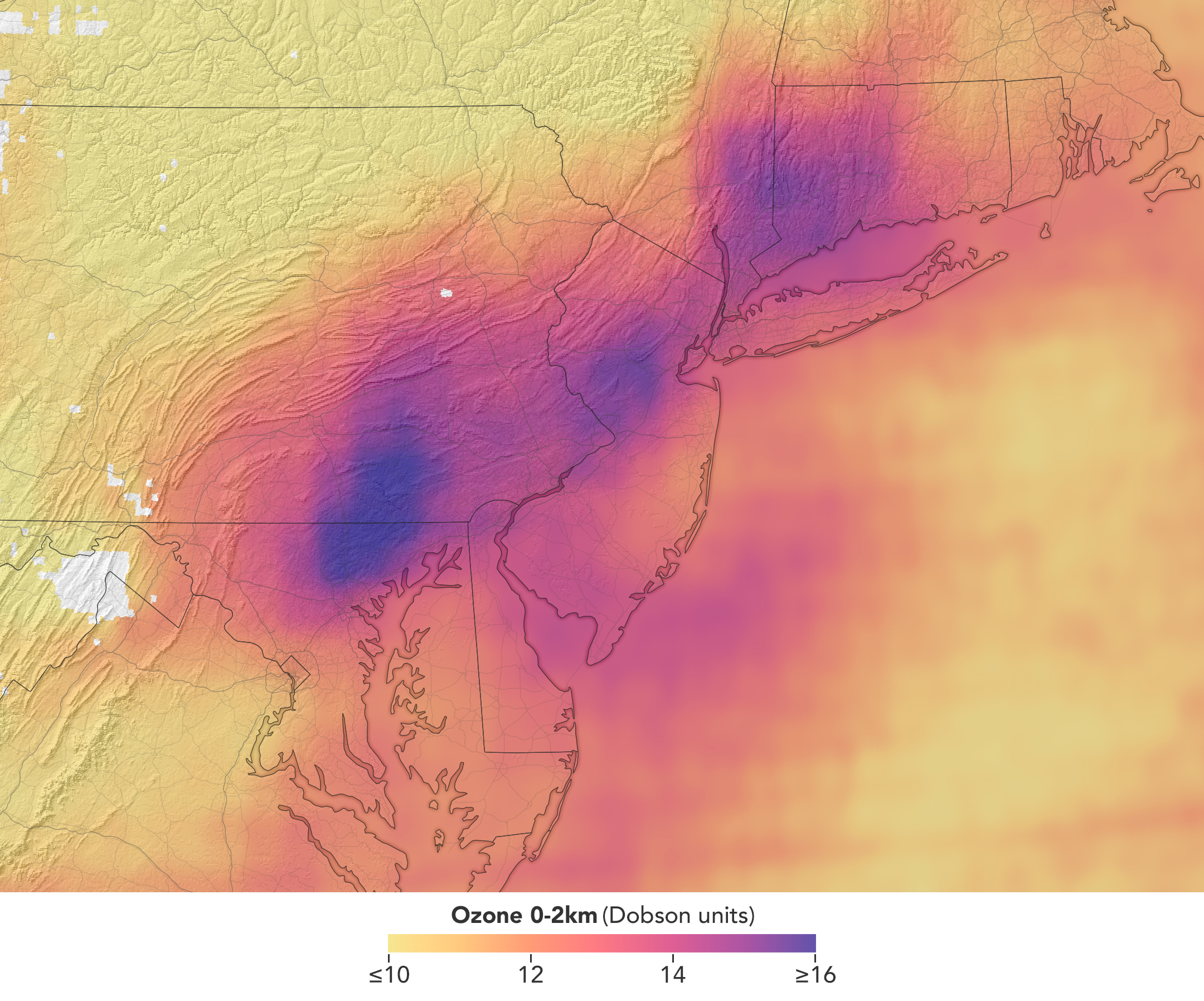
TEMPO detected elevated ozone concentrations in an area extending from New York City to Washington, D.C., at 5:05 p.m. on May 18, 2026.
NASA Earth Observatory/Michala Garrison
TEMPO also detects ozone directly, but determining how much of that ozone is near the surface versus higher in the atmosphere can be challenging. Most of Earth’s ozone resides in the stratosphere, well above the troposphere, where people live and breathe. At times, however, stratospheric ozone can be transported downward into the troposphere. During events known as stratospheric intrusions, it can even descend far enough to affect air quality at the surface and add to the ozone produced at ground level.
By combining TEMPO observations with other sources of information, researchers are studying the processes that influence the distribution of ozone vertically in the atmosphere. On May 18, NASA’s ground-based tropospheric lidar network (TOLNet) in New York City recorded high concentrations of ozone near the surface, indicating that TEMPO was detecting mostly surface-level ozone associated with urban emissions and not ozone aloft, said Mahmoud.
However, on May 19, the same sensor observed a layer of ozone descending from above 5 kilometers (3 miles), he added, a clue that some of the ozone TEMPO detected that day may have originated in the stratosphere. “This is the type of information that leads to better air quality forecast models and more accurate alerts,” Mahmoud said. “Alerts can affect tens of millions of people and lead to disruptions in school, sports, and other activities, so it’s essential that they be as accurate as possible.”
On June 6, New York authorities issued another health advisory for ozone. People interested in following the event can access daily near-real-time TEMPO observations of ozone, nitrogen dioxide, and other gases on NASA’s Worldview browser, on an interactive Harvard & Smithsonian Center for Astrophysics browsing tool, and on NASA’s Earthdata portal.
NASA Earth Observatory images by Michala Garrison, using TEMPO data from NASA Earthdata.Story by Adam Voiland.
TEMPO detected high concentrations of nitrogen dioxide during the morning commute at 7:05 a.m. local time on May 18, 2026 (left), along the New York-Washington corridor. The instrument detected lower levels of the gas at 3:05 p.m. (right), after chemical reactions involving nitrogen dioxide had contributed to elevated ozone concentrations in the afternoon.
NASA Earth Observatory/Michala Garrison
7:05 am
3:05 pm
TEMPO detected high concentrations of nitrogen dioxide during the morning commute at 7:05 a.m. local time on May 18, 2026 (left), along the New York-Washington corridor.The instrument detected lower levels of the gas at 3:05 p.m. EDT (right), after chemical reactions involving nitrogen dioxide had contributed to elevated ozone concentrations in the afternoon. NASA Earth Observatory images by Michala Garrison.
More than 35 million people live along the New York–Washington corridor and breathe the region’s air. While air quality has improved significantly in recent decades, outbreaks of ground-level ozone remain common, particularly in the warm summer months, when the chemical reactions that produce the pollutant accelerate and stagnant air allows ozone to accumulate.
A reminder of this seasonal phenomenon came earlier than usual in 2026, when a mid-May heat wave prompted the New York State Department of Health and the New York Department of Environmental Conservation to issue a health advisory on May 17 over concerns about ozone. The code orange advisory warned young people, older adults, and those working or exercising outdoors to limit activity due to ozone’s respiratory and cardiovascular health impacts.
As expected, ground-based air-quality sensors operated by state and federal agencies showed ozone reaching unhealthy levels for sensitive groups on May 18, something that typically happens several times per year. Meanwhile, NASA’s TEMPO (Tropospheric Emissions: Monitoring of Pollution) instrument observed the event from geostationary orbit 22,000 miles (35,000 kilometers) above the equator, a unique vantage point that allows the sensor to collect frequent observations of air pollution.
TEMPO detects nitrogen dioxide (NO2), a gas emitted by burning fuels, particularly by motor vehicles, that contributes to ozone formation. “There’s often a clear and interesting pattern in TEMPO’s nitrogen dioxide data during ozone alert days,” said Hazem Mahmoud, an atmospheric scientist at NASA’s Atmospheric Science Data Center at Langley Research Center. “We see high concentrations of nitrogen dioxide during the early morning commute that drop off sharply in the late afternoon as ozone increases.”
The decline occurs as sunlight fuels photochemical reactions involving nitrogen dioxide, volatile organic compounds, and oxygen that lead to ozone formation. By late afternoon, these reactions deplete much of the available nitrogen dioxide, slowing ozone production until the cycle begins again the next day.
The pair of images above underscores the pattern. The image on the left was acquired at 7:05 a.m. local time when nitrogen dioxide concentrations were high during the morning commute. By 3:05 p.m. (right), most of the nitrogen dioxide had declined substantially, and surface ozone levels were elevated (below). Meanwhile, afternoon sea breezes appear to have transported the remaining nitrogen dioxide slightly to the west. Note that the data shown is provisional, and processing methods are still being refined.
Sensors on earlier polar-orbiting satellites, such as OMI (Ozone Monitoring Instrument) and TROPOMI (Tropospheric Monitoring Instrument), sampled nitrogen dioxide over New York once per day. After its launch in 2023, TEMPO began providing data every hour, allowing researchers to track the evolution and dispersion of air pollution at much finer time scales.
“TEMPO is helping fill data gaps between ground stations and allowing us to ask new questions,” Mahmoud said. The mission provides data that can improve not only air quality forecasts during crisis situations, such as wildfires, but also the atmospheric models used to forecast the daily rhythms of urban pollution. Such models help researchers understand how natural factors such as winds, humidity levels, and air temperatures influence pollution plumes over the course of a day.
TEMPO detected elevated ozone concentrations in an area extending from New York City to Washington, D.C., at 5:05 p.m. on May 18, 2026.
NASA Earth Observatory/Michala Garrison
TEMPO also detects ozone directly, but determining how much of that ozone is near the surface versus higher in the atmosphere can be challenging. Most of Earth’s ozone resides in the stratosphere, well above the troposphere, where people live and breathe. At times, however, stratospheric ozone can be transported downward into the troposphere. During events known as stratospheric intrusions, it can even descend far enough to affect air quality at the surface and add to the ozone produced at ground level.
By combining TEMPO observations with other sources of information, researchers are studying the processes that influence the distribution of ozone vertically in the atmosphere. On May 18, NASA’s ground-based tropospheric lidar network (TOLNet) in New York City recorded high concentrations of ozone near the surface, indicating that TEMPO was detecting mostly surface-level ozone associated with urban emissions and not ozone aloft, said Mahmoud.
However, on May 19, the same sensor observed a layer of ozone descending from above 5 kilometers (3 miles), he added, a clue that some of the ozone TEMPO detected that day may have originated in the stratosphere. “This is the type of information that leads to better air quality forecast models and more accurate alerts,” Mahmoud said. “Alerts can affect tens of millions of people and lead to disruptions in school, sports, and other activities, so it’s essential that they be as accurate as possible.”
On June 6, New York authorities issued another health advisory for ozone. People interested in following the event can access daily near-real-time TEMPO observations of ozone, nitrogen dioxide, and other gases on NASA’s Worldview browser, on an interactive Harvard & Smithsonian Center for Astrophysics browsing tool, and on NASA’s Earthdata portal.
NASA Earth Observatory images by Michala Garrison, using TEMPO data from NASA Earthdata.Story by Adam Voiland.
The Southern Patagonian Icefield is the largest expanse of ice in the Southern Hemisphere outside of Antarctica. The mass of glacial ice extends hundreds of kilometers along the spine of the Andes, feeding dozens of dynamic outlet glaciers that grind their way down from higher elevations. Many of these rivers of ice terminate in the sea or in proglacial lakes.
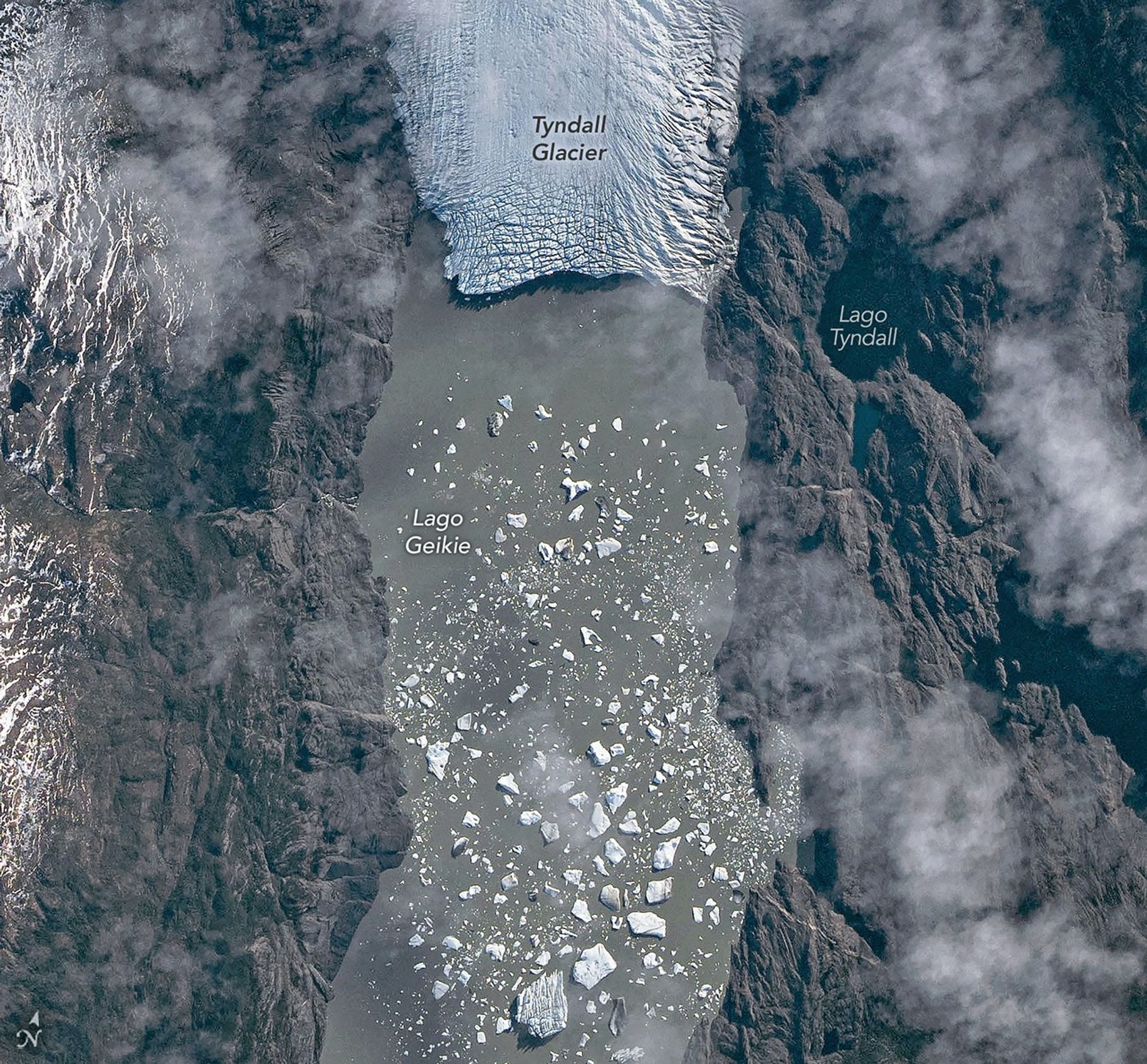
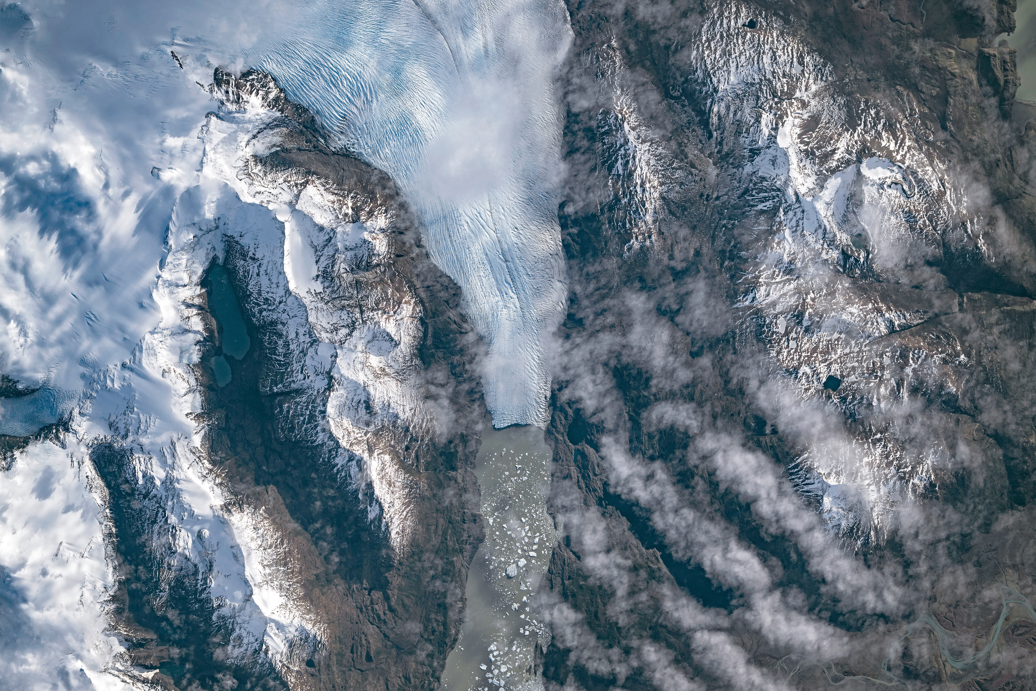
An astronaut aboard the International Space Station photographed one of these glaciers—Tyndall Glacier in southern Chile—through a layer of ethereal clouds on May 10, 2026. Fragments of ice that had calved off its terminus were visible floating on Lago Geikie.
Like most Patagonian glaciers, Tyndall has been shrinking since the end of the Little Ice Age about 150 years ago. Lago Geikie formed at Tyndall’s terminus around 1940, according to glaciologist Mauri Pelto of Nichols College, and gradually expanded as the ice retreated. Part of the glacier previously terminated in Lago Tyndall to the east, but thinning ice cut off that outlet by 2010, Pelto said. (The ice’s retreat also exposed bedrock along its eastern edge that contains scores of ichthyosaur fossils.)
Along with thinning, ice calving off the glacier’s front has reduced its volume. Tyndall has lost 2.2 kilometers (1.4 miles) in length since November 2022, Pelto said, following about a decade of limited retreat with considerable thinning. A significant calving event in March and April 2023 contributed to the recent uptick in ice retreat. During that time, satellites observed several large icebergs breaking away from Tyndall’s terminus.
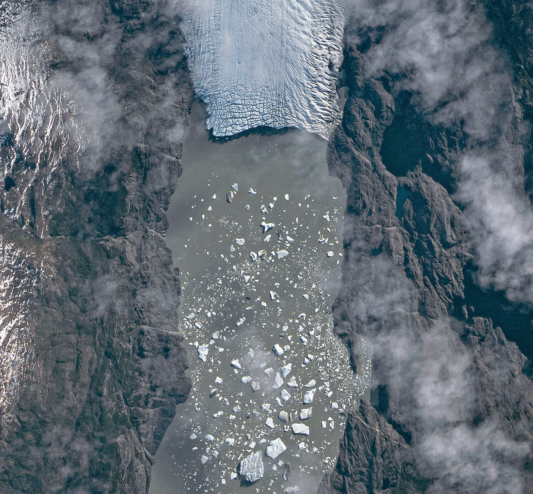
Austral autumn in 2026 was a time of active calving retreat at Tyndall (and some neighboring glaciers), Pelto said, albeit more incremental than three years prior. “The substantial crevasses crisscrossing the glacier near the calving front lead to many smaller icebergs,” he said. On the other hand, larger tabular icebergs tend to form when there are fewer deep crevasses near the terminus and the glacier’s ice is thinner.
May 10, 2026
The ice cliff at the terminus casts a substantial shadow, which can help scientists estimate the height of the glacier’s front. Pelto’s calculations, using information about the Sun’s position provided with the image, indicate that Tyndall’s front loomed 30–40 meters (100–130 feet) above the lake surface in May 2026. Observations from orbit, including astronaut photographs, can help scientists monitor and understand glaciers in remote regions where ground-based observations are scarce.
As for what comes next for Tyndall, Pelto expects many more small icebergs to continue breaking off, given the heavily crevassed appearance of the calving front. “Look for a burst of iceberg production next fall.”
Astronaut photograph ISS074-E-582898 was acquired on May 10, 2026, with a Nikon Z9 digital camera using a focal length of 560 millimeters. It is provided by the ISS Crew Earth Observations Facility and the Earth Science and Remote Sensing Unit at NASA Johnson Space Center. The image was taken by a member of the Expedition 74 crew. The image has been cropped and enhanced to improve contrast, and lens artifacts have been removed. The International Space Station Program supports the laboratory as part of the ISS National Lab to help astronauts take pictures of Earth that will be of the greatest value to scientists and the public, and to make those images freely available on the Internet. Additional images taken by astronauts and cosmonauts can be viewed at the NASA/JSC Gateway to Astronaut Photography of Earth. Story by Lindsey Doermann.
Every month, NASA Earth Observatory features a puzzling satellite image. The June 2026 puzzler appears above.
Your Challenge Identify the location shown in this satellite image. Share what clues you see, where you think it is, and what makes this place interesting or unique to you.
How to Answer Submit your response using this form and select “Puzzler Answer” as the topic. Please include your preferred name or alias.
You can keep it simple and just guess the location. Want to impress us? Tell us which satellite and instrument captured the image, which spectral bands were used, or point out a subtle detail about the geology or history of the area. If something catches your eye, or if this is your home or means something to you, we’d love to hear about it.
The Prize We can’t offer prize money or a trip to space to see Earth like satellites and astronauts do. But we can offer something almost as rewarding: puzzler bragging rights.
About a week after the challenge, we’ll post the answer at the top of this page, along with a link to an Earth Observatory Image of the Day story that explains the image in more detail. We’ll recognize the first person who correctly guesses the location, and we may also highlight readers who share especially thoughtful or interesting answers. By submitting a response, you acknowledge that your comments may be edited, excerpted, and published on this page.
Until then, zoom in, look closely, and enjoy the challenge. See you at the reveal!
A period of unsettled weather brought scattered showers and thunderstorms to California’s Bay Area on May 27, 2026. That afternoon, a break in the clouds left downtown San Francisco and nearby communities beneath mostly cloud-free skies, allowing an astronaut aboard the International Space Station to take this photograph.
The image captures two of the region’s iconic bridges. The Golden Gate Bridge connects the northern San Francisco Peninsula with Marin County to the north, while the San Francisco-Oakland Bay Bridge spans the bay toward Oakland to the east.
Near the center of the image, Golden Gate Park stands out as a long, rectangular strip of green amid the dense urban landscape. Spanning more than 1,000 acres (400 hectares), the park encompasses meadows, gardens, wooded areas, and lakes. Additional green space toward the north around the Golden Gate Bridge is part of a national recreation area.
The nadir (downward-looking) perspective also provides a clear view of the patchwork of street grids, which were laid out over San Francisco’s hilly terrain as the city grew in successive stages. In the heart of the downtown area, Market Street runs southwest to northeast and serves as a prominent divider between two distinct grid orientations: one aligned with the bay and the other aligned with the street.
Along the northeastern and eastern waterfront, various structures extend into the bay. Toward the north, these include a historic wharf, seawalls, and piers—most built in the early 1900s, though some date back into the 1800s. The adjacent waters support heavy maritime traffic, including cargo and container ships, cruise vessels, and regional ferries.
Breaking waves are visible along the western coast, including at Ocean Beach, the 3.5-mile stretch of sandy shore adjacent to Golden Gate Park. On May 27, the National Weather Service warned of hazardous conditions at the region’s beaches due to strong northerly winds. Long-period swells from the northwest contributed to the increased risk of rip currents as well as sneaker waves in the days after this image was acquired.
Astronaut photograph ISS074-E-619284 was acquired on May 27, 2026, with a Nikon Z9 digital camera using a focal length of 800 millimeters. It is provided by the ISS Crew Earth Observations Facility and the Earth Science and Remote Sensing Unit at NASA Johnson Space Center. The image was taken by a member of the Expedition 74 crew. The image has been cropped and enhanced to improve contrast, and lens artifacts have been removed. The International Space Station Program supports the laboratory as part of the ISS National Lab to help astronauts take pictures of Earth that will be of the greatest value to scientists and the public, and to make those images freely available on the Internet. Additional images taken by astronauts and cosmonauts can be viewed at the NASA/JSC Gateway to Astronaut Photography of Earth. Story by Kathryn Hansen.
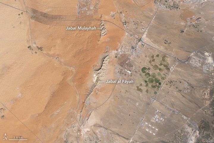
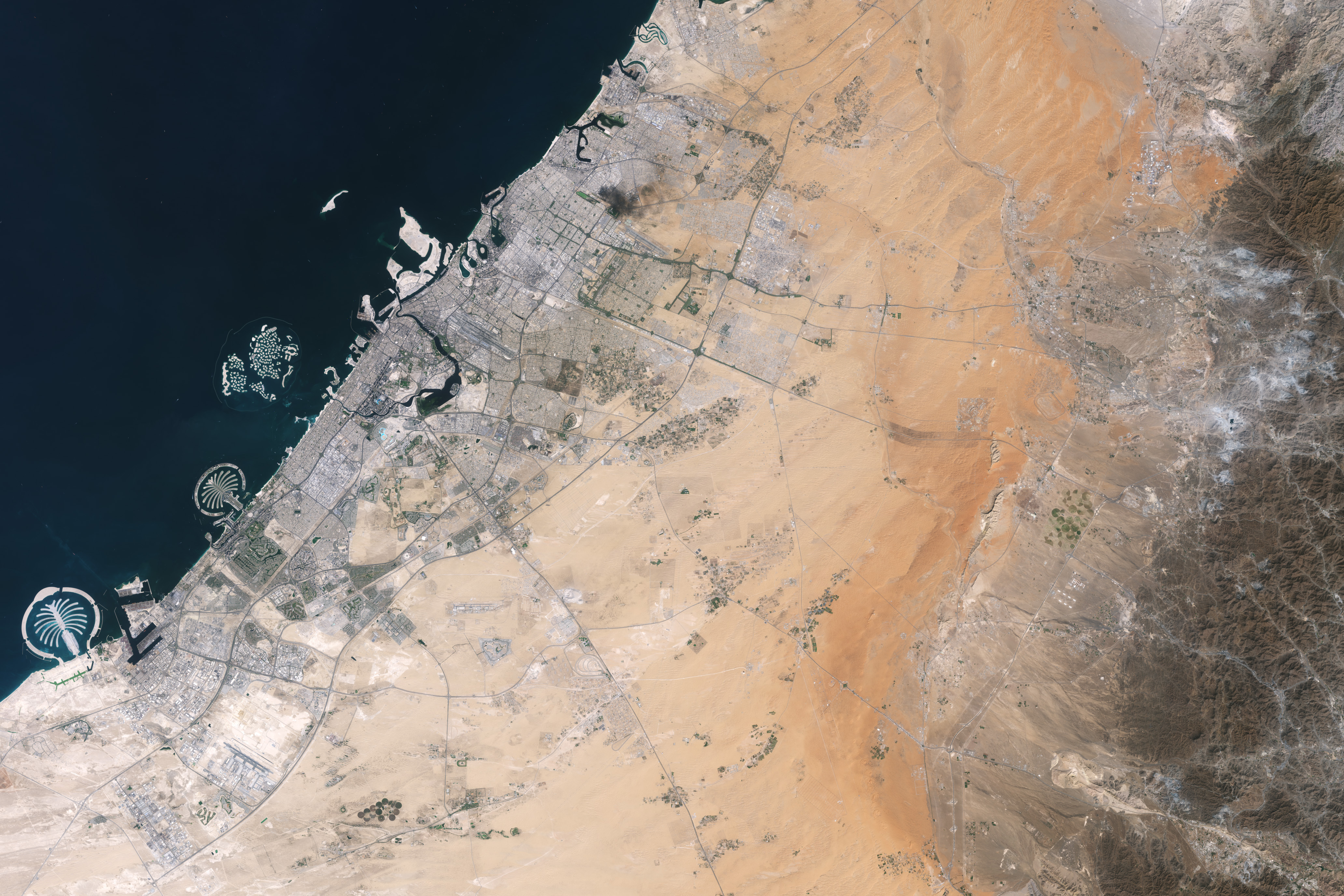
Jabal al Fāyah rises from the Rub’ al Khali desert in an image captured by the OLI (Operational Land Imager) on Landsat 8 on October 23, 2025.
NASA Earth Observatory / Lauren Dauphin
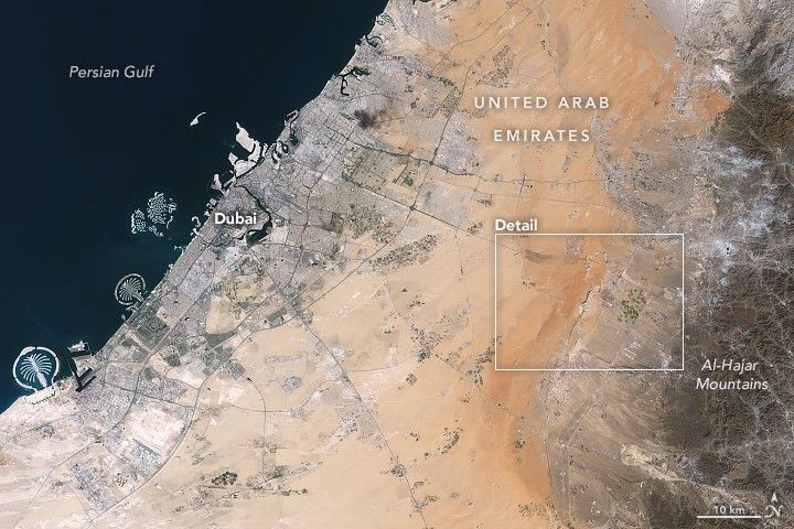
About an hour’s drive east of Dubai’s gleaming towers and artificial islands, a quieter, more natural landscape takes shape. At the far northern edge of the Rub’ al Khali, a saffron-colored sand sea laps against the Al-Hajar Mountains. A series of pale ridges rises finlike from the desert plain, with the largest—Jabal al Fāyah—standing 412 meters (1,352 feet) above sea level.
The Landsat 8 satellite captured this image of the ridges cutting across the Emirate of Sharjah in the northern part of the United Arab Emirates on October 23, 2025. To geologists, the limestone ridges are a reminder of the region’s watery past, signs that this land lay underwater tens of millions of years ago when the sedimentary rock layers were deposited.
Jabal al Fāyah functions as a barrier, trapping windblown sand in dune fields to its west. The weathering of iron-bearing minerals in the sand grains gives the dune fields their orange hue. To the east, the branching channels of overlapping alluvial fans extending from the Al-Hajar Mountains carry gravels and eroded sediments from basalts and other dark mafic rocks.
The dark rocks to the east—part of the Samail Ophiolite—are known to geologists for being among the world’s largest, best-preserved, and most accessible exposures of ancient oceanic lithosphere, the rigid outer layer of Earth that includes both the crust and upper mantle. Oceanic lithosphere like this is normally subducted and recycled back into the mantle when tectonic plates collide. But in this area, a large section from beneath the Tethys Sea was scraped off and thrust onto the Arabian plate in a process called obduction.
Dubai lies to the west of the limestone ridges, and the Al-Hajar Mountains lie to the east, in an image acquired by the OLI (Operational Land Imager) on Landsat 8 on October 23, 2025.
NASA Earth Observatory / Lauren Dauphin
The Jabal al Fāyah ridges themselves are made up of marine limestone that was deposited on top of the ophiolite over tens of millions of years spanning the late Cretaceous through the early to mid-Paleocene. Limestone typically forms along continental margins in warm, shallow oceans, often in lagoons and coral reefs, out of the calcium carbonate found in the shells and skeletons of marine life. In many parts of the ridges, coral fragments and marine invertebrate fossils are visible embedded in the rock. A feature called Fossil Rock sits a few kilometers north of Jabal al Fāyah and adjacent to the limestone ridge Jabal Mulayḩah. It contains an abundance of snail, clam, and sea urchin remains.
For archaeologists, the ridges are at the center of a much more recent tale of human adaptation and survival that has played out in just the past few hundred thousand years. The ridges and parts of the surrounding landscape—inscribed as a UNESCO World Heritage site in 2025—are dotted with dozens of archaeological sites that trace human occupation on the Arabian Peninsula back to between 210,000 and 120,000 years ago, to the Middle Paleolithic. That was a period when waves of anatomically modern humans (Homo sapiens) migrated out of Africa and shared the planet with other groups such as Neanderthals.
Many of the sites contain stone flakes, blades, scrapers, hand axes, and other stone tools. The archaeological treasure trove offers early evidence of modern humans surviving in a harsh desert environment and raises questions about the routes modern Homo sapiens may have taken on their journey out of Africa.
Geological evidence indicates that lakes periodically formed on the east side of the ridge, providing critical food and water resources that would have supported early inhabitants in this unforgiving climate. Rocky overhangs along the ridge would have provided shelter from the heat and wind. Some of the sites show evidence of intermittent occupation beginning as early as 210,000 years ago, making this one of the earliest signs of human habitation on the Arabian Peninsula.
NASA Earth Observatory images by Lauren Dauphin, using Landsat data from the U.S. Geological Survey. Story by Adam Voiland.
Smoke streams from fires in Australia’s Northern Territory in an image captured by the MODIS (Moderate Resolution Imaging Spectroradiometer) on NASA’s Aqua satellite on May 28, 2026.
NASA Earth Observatory/Michala Garrison
In May and June of most years, NASA satellites typically begin to detect large numbers of wildland fires throughout the Top End and Arnhem Land regions of Australia’s Northern Territory. On some days, especially in the afternoon, the blazes can resemble sizable wildfires in satellite imagery, spreading widely and producing expansive smoke plumes.
That was the case when NASA’s Aqua satellite acquired this image of smoke and fires on the afternoon of May 28, 2026. Often, however, fires burning in this area look smaller and less imposing. In the mornings just a few days earlier and later, for instance, NASA satellites detected little smoke despite observing many thermal anomalies, or hotspots, that indicated fire activity.
The pattern of burning, location, and timing are consistent with prescribed fires lit intentionally to manage the landscape. Land managers tend to light fires in the morning, and smoke builds over the course of the day. The process sometimes creates sizable plumes when there are updrafts and winds of moderate strength that carry smoke away from the fires, as happened on May 28 and again on June 2. The fires typically burn through the fire-adapted grasses, underbrush, and scattered trees in the region’s tropical savanna ecosystems.
Over the past few decades, the region’s land managers have combined deep-rooted Indigenous land management practices and modern technologies to establish large-scale landscape management programs such as the West Arnhem Land Fire Abatement project and Arnhem Land Fire Abatement. The goal of such efforts is to intentionally burn some of the savanna underbrush to create firebreaks and reduce fuel loads early in the dry season, reducing more destructive and emissions-intensive fires later in the season. The dry season generally begins in May and extends through September, according to Australia’s Bureau of Meteorology.
While research is ongoing, there are signs that the prescribed burning efforts are having the intended effect. Analysis of satellite observations of the fires suggests that prescribed burning efforts have shifted fire activity from late to early in the dry season, leading to a reduction in high-intensity fires and emissions.
NASA Earth Observatory image by Michala Garrison, using MODIS data from NASA EOSDIS LANCE and GIBS/Worldview. Story by Adam Voiland.
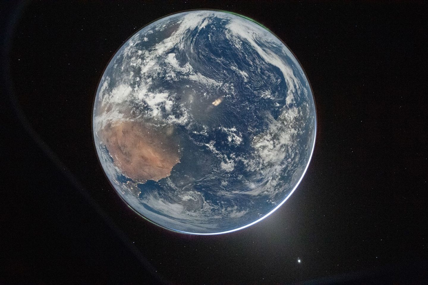
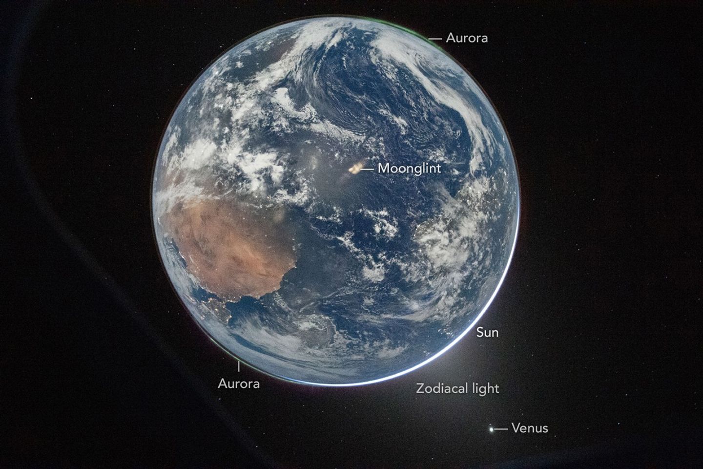
One of the first images transmitted back to Earth from the Artemis II mission was a stunner. In a single image, Earth’s full disk appears amid celestial phenomena that illustrate its place in the solar system. And although the visible hemisphere appears to be awash in sunlight, it is actually lit by moonlight. The astronauts’ vantage point provided a rare opportunity to capture nighttime features—most notably lights from human habitation—from a new perspective.
An Artemis crew member captured the photo from the Orion spacecraft after it completed the translunar injection burn, which sent the spacecraft out of Earth orbit and on a trajectory toward the Moon. In the photo, Earth eclipses the Sun from Orion’s perspective, leaving only a small sliver of its bright light visible around the bottom right edge. Green auroras, caused by charged particles from the Sun interacting with Earth’s upper atmosphere, glow around the north and south poles (lower left and upper right, respectively).
The Sun’s light also produces the fuzzy glow, known as zodiacal light, that appears to the lower right of Earth. This phenomenon comes from sunlight reflecting off interplanetary dust. Skywatchers on Earth may see it at certain times of year around dawn or dusk as a faint column of light extending up from the horizon. Data collected by NASA’s Juno spacecraft on its journey to Jupiter suggest that Mars may be a significant source of the dust particles that produce zodiacal light. Earth’s other planetary neighbor, Venus, appears as the bright object in the bottom right of the image.
April 2, 2026
On Earth itself, city lights are evidence of human activity. Bright areas appear in Spain, Portugal, and northern Africa (lower left), sub-Saharan Africa (center left), and Brazil (center right). Digital camera technology—with help from the illumination of a full Moon—made it possible to see these and other details of Earth’s surface and atmosphere in low light. The crew set the camera’s ISO to 51,200 to make it highly sensitive to light. For comparison, an ISO setting of 100 or 200 is common for daytime photography.
Previous nighttime views of Earth taken from spacecraft may look very different from this photo but have also inspired and enlightened. For instance, the Apollo 12 crew photographed Earth eclipsing the Sun in 1969; astronaut Alan Bean would go on to depict his impressions of the event in paintings.
More recently, astronauts aboard the International Space Station have photographed the planet at night from low Earth orbit, while NASA’s Black Marble nighttime lights product suite uses satellite observations to produce science-quality records of nighttime lights at daily, monthly, and yearly time scales. Those programs provide sustained data records, while the Artemis II photo is distinctive as a single human-captured full-disk view showing many low-light features at once.
Cindy Evans, senior exploration scientist in the Astromaterials Research and Exploration Science Division at NASA’s Johnson Space Center, was working in the Science Evaluation Room during the Artemis II mission and was one of the first people on Earth to see the image. Evans was struck both by its beauty and the perspective revealed by all the visible solar system features. “I love the image so much because it was taken with Earth in moonshine, and shows Earth as a solar system body, a dynamic planet interacting with the solar wind, and a place harboring life,” she said.
The image is scientifically valuable, as well, said Miguel Román, Deputy Director for Atmospheres and Data Systems at NASA’s Goddard Space Flight Center. “It speaks powerfully to the breadth of what NASA does across science and human exploration,” he said. Román studies artificial light at night, as viewed from space, as a measurable signal of human activity.
“[This photo] reminds us that Earth at night is visually compelling, physically complex, and scientifically underexplored,” Román said. “I see this image as a glimpse of what Earth science can become in the future.”
NASA images prepared for Earth Observatory by Lauren Dauphin. Story by Lindsey Doermann.
Typhoon Jangmi dazzled from space with a giant swirling eye while drenching parts of Japan with heavy rain. From late May into early June 2026, Typhoon Jangmi slowly tracked north-northwest across the Philippine Sea on a path toward southern Japan. Although the storm moved at a relatively slow pace, it spread intense rainfall across a [...]
A rapidly intensifying super typhoon sent giant atmospheric ripples skyward, revealing a hidden connection between extreme weather and near-space. In April 2026, Super Typhoon Sinlaku swept across the North Pacific, bringing torrential rain and flooding to parts of the Mariana Islands. The storm intensified into a “violent typhoon,” the highest category used by the Japan [...]

 Login