Chile's Atacama Desert, which gets less than 5 millimeters (0.2 inches) of rainfall each year, started to form more than 40 million years ago — 20 million years before the Andes.
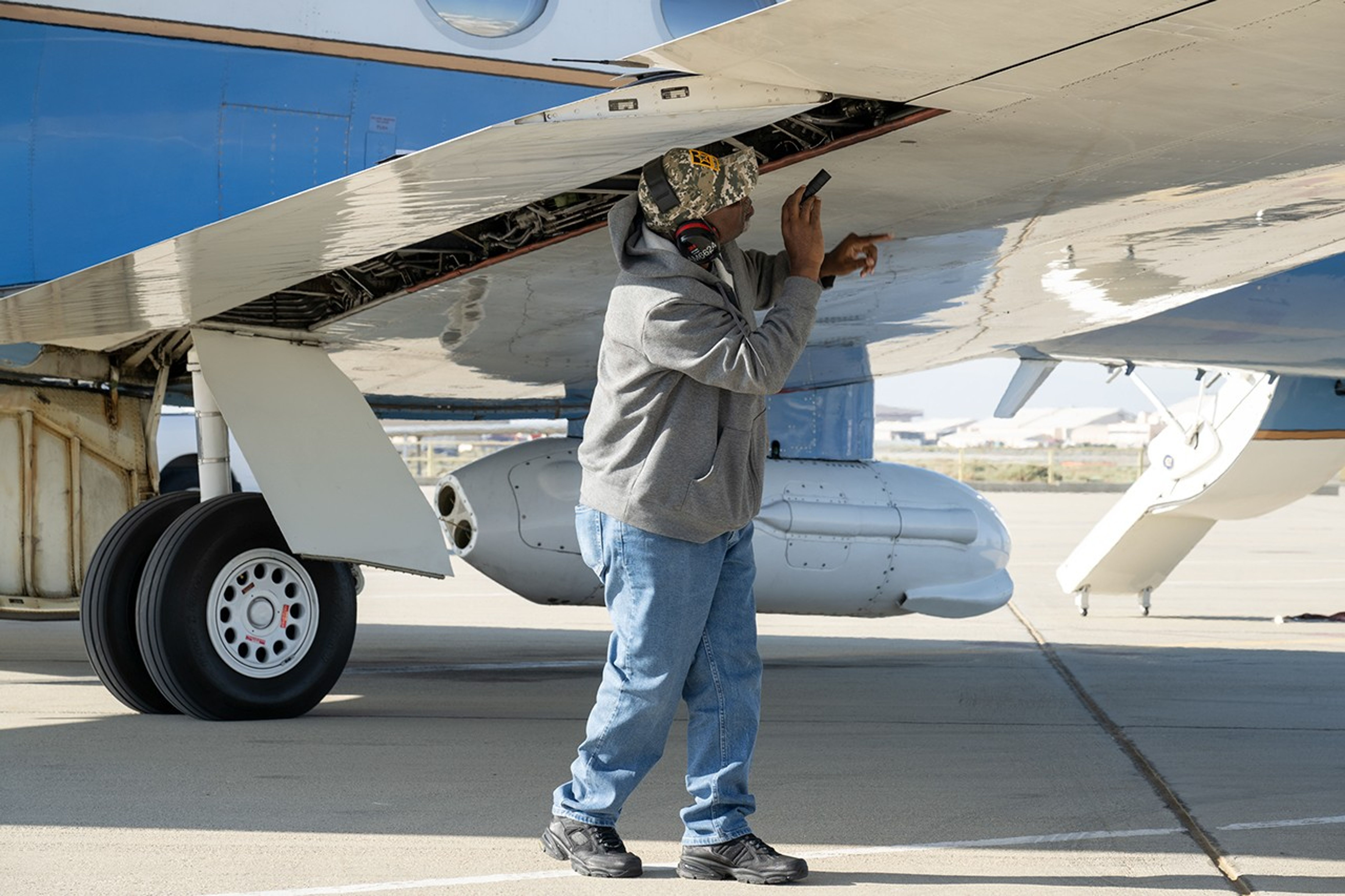
Alvin Mitchell, a NASA C-20A aircraft quality assurance inspector, completes preflight checks at NASA’s Armstrong Flight Research Center in Edwards, California, on April 29 for a mission over Central California. On May 2, the aircraft departed for the Tropical Synthetic Aperture Radar campaign carrying NASA’s Uninhabited Aerial Vehicle Synthetic Aperture Radar.
NASA/Ryan Kline
Data from a NASA campaign in Panama and Peru will help communities prepare for tropical floods in cloud-covered areas, improve scientific understanding of forest health, and support planning for spaceborne missions.
NASA’s C-20A aircraft from Armstrong Flight Research Center in Edwards, California, flew the Uninhabited Aerial Vehicle Synthetic Aperture Radar (UAVSAR) instrument, developed at NASA’s Jet Propulsion Laboratory in Southern California, to gather mission data. While flying repeat paths, the instrument collected high-resolution radar data from a pod mounted beneath the aircraft. The monthlong campaign, known as Tropical Synthetic Aperture Radar, or TropiSAR, concluded on June 4 after 17 flights totaling 75 hours.
Airborne data were captured over Peru in the same times and locations as data captured by the NISAR (NASA-ISRO Synthetic Aperture Radar) satellite to validate key NISAR capabilities and support calibration of the satellite’s L-band radar system. The science validation targeted two measurements: tropical rainforest flood extent within the Pacaya-Samiria National Reserve in Peru, one of the world’s largest protected flooded forests, and glacier movement in the Huascarán National Park in the Peruvian Andes, which is home to the largest concentration of tropical glaciers. The mission also gathered detailed 3D views of tree height and density to estimate biomass, assess forest health, and better understand how forest ecosystems store and release carbon.
In Panama, TropiSAR also supported NASA’s Airborne Validation Unified Experiment: Land and Ocean (AVUELO) campaign in collaboration with the Smithsonian Tropical Research Institute. Airborne radar data were collected from dry forests and coastal wetlands with the goal of better understanding Panama’s rich biodiversity. By linking field measurements with airborne and satellite observations, AVUELO may advance new methods for studying the tropics.
China is building a dam system that will generate more hydroelectric power than the U.S. generates yearly. But the project comes with huge risks for people downstream.
A period of unsettled weather brought scattered showers and thunderstorms to California’s Bay Area on May 27, 2026. That afternoon, a break in the clouds left downtown San Francisco and nearby communities beneath mostly cloud-free skies, allowing an astronaut aboard the International Space Station to take this photograph.
NASA
An astronaut aboard the International Space Station took this picture of downtown San Francisco and nearby communities on May 27, 2026. The image captures two of the region’s iconic bridges. The Golden Gate Bridge connects the northern San Francisco Peninsula with Marin County to the north, while the San Francisco-Oakland Bay Bridge spans the bay toward Oakland to the east.
Pas besoin d'installer quoi que ce soit : depuis le 12 juin, Google Earth propose un simulateur de vol entièrement gratuit, directement utilisable dans le navigateur. Une fonctionnalité longtemps réservée aux initiés qui s'ouvre à tous pour changer de point de vue.
Does the fact that we see light from very distant galaxies prove that the one-way speed of light is finite? Dr. Jason Lisle responds to this question. The conventionality thesis plays a critical role in understanding the issue, suggesting that measurements usually assume an isotropic light speed.
Lead researcher Federico De Pascalis of the Italian Institute for Environmental Protection and Research (ISPRA) holds a Mediterranean storm petrel.
A. Benvenuti
You might think birds skimming over the ocean wouldn’t seek wind unless it was pushing them in the right direction, but NASA-funded researchers have learned that storm petrels find stiff crosswinds worth the slowdown, in return for the clues and cues the gusts carry.
In a paper published by the Royal Society’s Biology Letters May 13, researchers from Woods Hole Oceanographic Institution (WHOI) and the Italian Institute for Environmental Protection and Research (ISPRA) found that Mediterranean storm petrels actively sought out crosswinds, which carried odors the birds used to navigate toward prey. The birds were effectively trading the extra energy needed to fly in a crosswind for the information it blows toward them.
These sparrow-sized birds routinely undertake foraging trips hundreds of miles over the sea, returning to the breeding colony to relieve their partners from incubation duties. Until recently, their small size has precluded researchers’ ability to tag them, keeping their journeys a mystery. In 2020 and 2021, working on the Italian island Sardinia, the team, led by ISPRA and WHOI, attached lightweight GPS sensors to the birds, adding just 3.3% of the birds’ weight as they set out over the Mediterranean Sea.
This finding could help reveal how changing winds might impact seabirds’ feeding, breeding, energy levels, and survival, adding insights about patterns of nutrients in the sea — and the forces that create them.
Sentinel-6 satellite data shows strengthening warm-water waves in the Pacific, pointing to the likely arrival of El Niño and its global weather impacts later in 2026. Several months before an El Niño develops, large waves of warmer, elevated water travel eastward across the Pacific Ocean. Satellite observations in 2026 have detected several of these waves. [...]
Scientists have confirmed a rare “impossible” earthquake deep beneath Utah, revealing a hidden source of seismic activity inside Earth’s mantle. Nearly five decades after a puzzling earthquake struck deep beneath northern Utah, scientists have confirmed that the event was real and part of a rare category of earthquakes that occur much deeper underground than researchers [...]
The National Oceanic and Atmospheric Administration gives the climate event a 63% chance to "rank among the largest El Niño events in the historical record going back to 1950."
Geologists recently converged on a site near Barstow, California, to ground-truth a mineral discovery made on public land by a NASA JPL sensor flying aboard a plane overhead.
NASA/JPL-Caltech
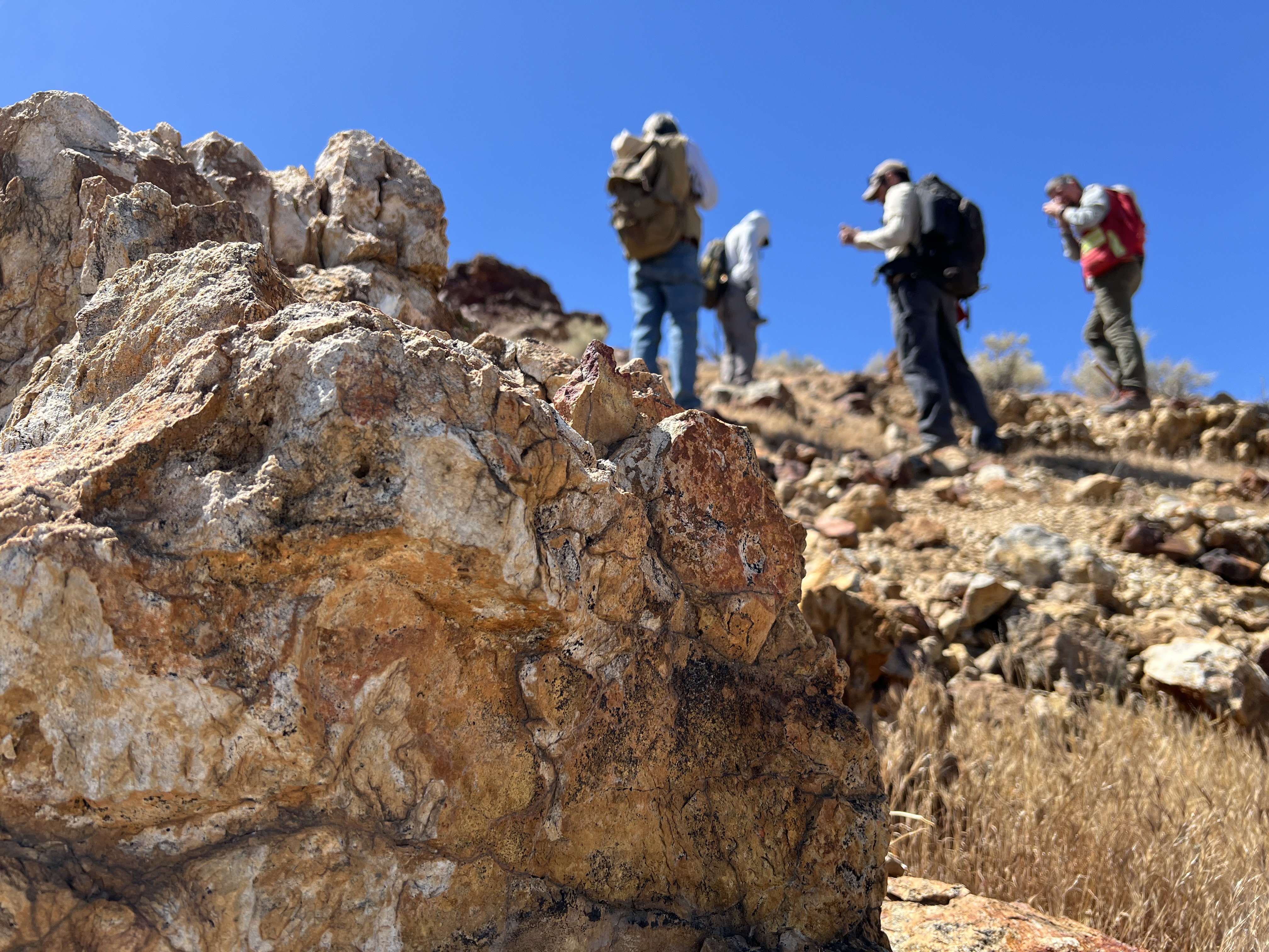
Equipped with rock picks and hand lenses, a team of geoscientists deployed to the Mojave Desert recently to investigate a tantalizing “fingerprint” detected by a NASA sensor. Their target: a cache of topaz hiding in plain sight.
The geologists weren’t searching for gem-grade treasure. Rather, the presence of topaz could hint at a more valuable deposit below of something known as porphyry copper.
One of the world’s primary sources of copper, these deposits are left behind when magma and hot water from deep underground course through Earth’s crust, chemically transforming the surrounding rock. This tends to occur where one tectonic plate dives below another, known as a subduction zone, such as the North American Cordillera, which stretches from the Canadian Rockies to western Mexico.
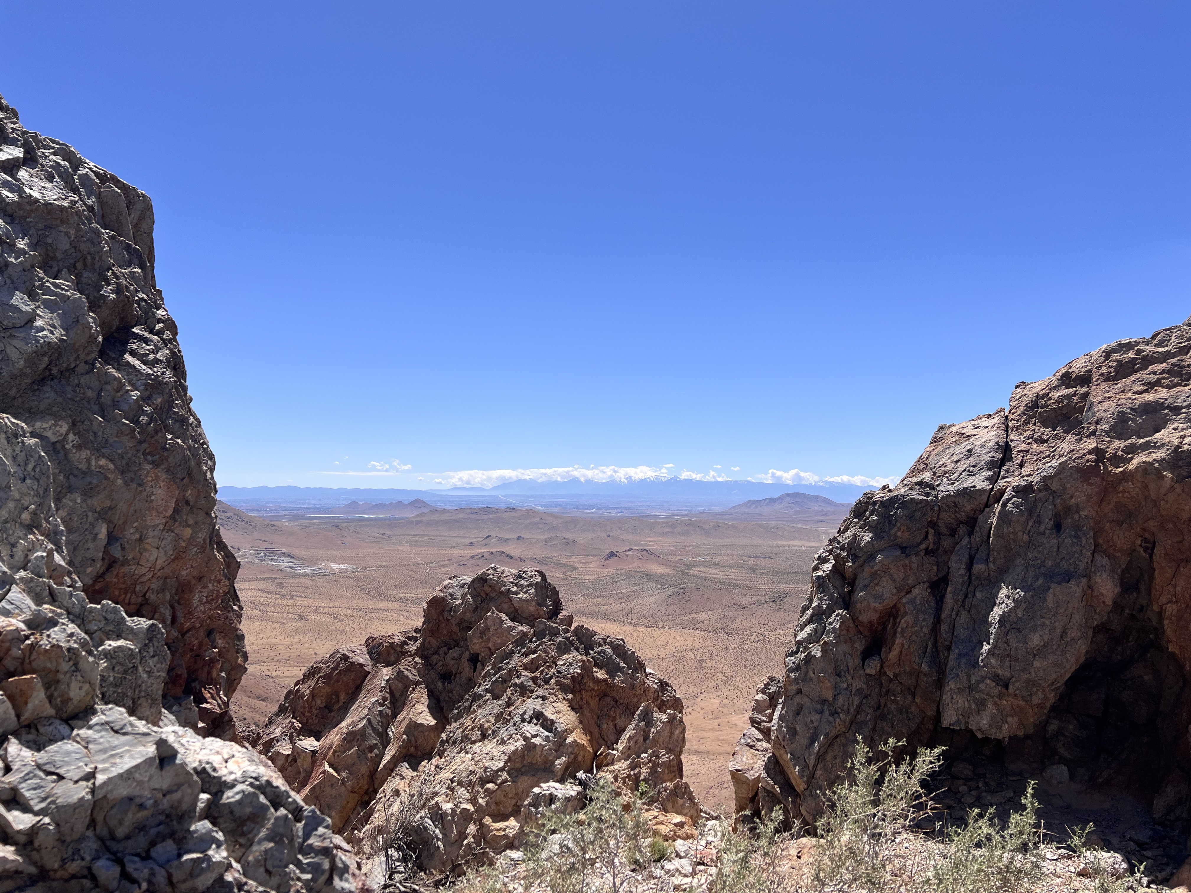
California’s high desert stretches below a bright spring sky in April 2026. NASA and USGS scientists are using airborne remote sensing to home in on potential sources of critical minerals here and across the Western U.S.
NASA/JPL-Caltech
In addition to copper — the third most used metal in the world after steel and aluminum — the deposits can hold other critical minerals like molybdenum and tellurium, which are used in everything from steelmaking to solar panels. Finding the deposits isn’t easy. Geologists look for topaz because it forms under the same volcanic conditions.
For the team in the Mojave, the goal was to collect more evidence. That would require boots on the ground and a heavy bag of samples. The scientists who converged on the site included three experts from the U.S. Geological Survey (USGS) and Robert Green of NASA’s Jet Propulsion Laboratory in Southern California.
“What we’re doing out here is geologic CSI,” said Green, referring to the investigative TV show, as he split open a weathered red rock to expose a sparkling core. “We’re looking for clues to reconstruct what happened here.”
Three-dimensional image cubes illustrate the volume of data captured by NASA imaging spectrometers. The front face shows an aerial view of the Mojave Desert. The colorful side panels reveal what no eye or camera can detect: the spectral fingerprints of minerals present in every pixel.
NASA/JPL-Caltech
Next-generation mineral mapping
The sensor that detected the topaz deposit on public land near Barstow, California, was built at JPL. Called AVIRIS, short for Airborne Visible Infrared Imaging Spectrometer, it analyzes reflected sunlight and can be used to identify chemicals and minerals by their unique spectral fingerprint. The technology was pioneered in the early 1980s by a team that included Green, and space-hardened versions have explored the Moon, Mars, and other rocky bodies in the solar system in the decades since.
While its cousins study distant worlds aboard spacecraft, the AVIRIS line of sensors is advancing Earth science from aircraft. The latest model, AVIRIS-5, recently took to the skies for the first time as part of the NASA-USGS Geologic Earth Mapping Experiment (GEMx). The goal of GEMx is to identify sources of critical minerals across the American West, including in the waste rock of active and legacy mines. It is led by the USGS as part of its larger, nationwide initiative.
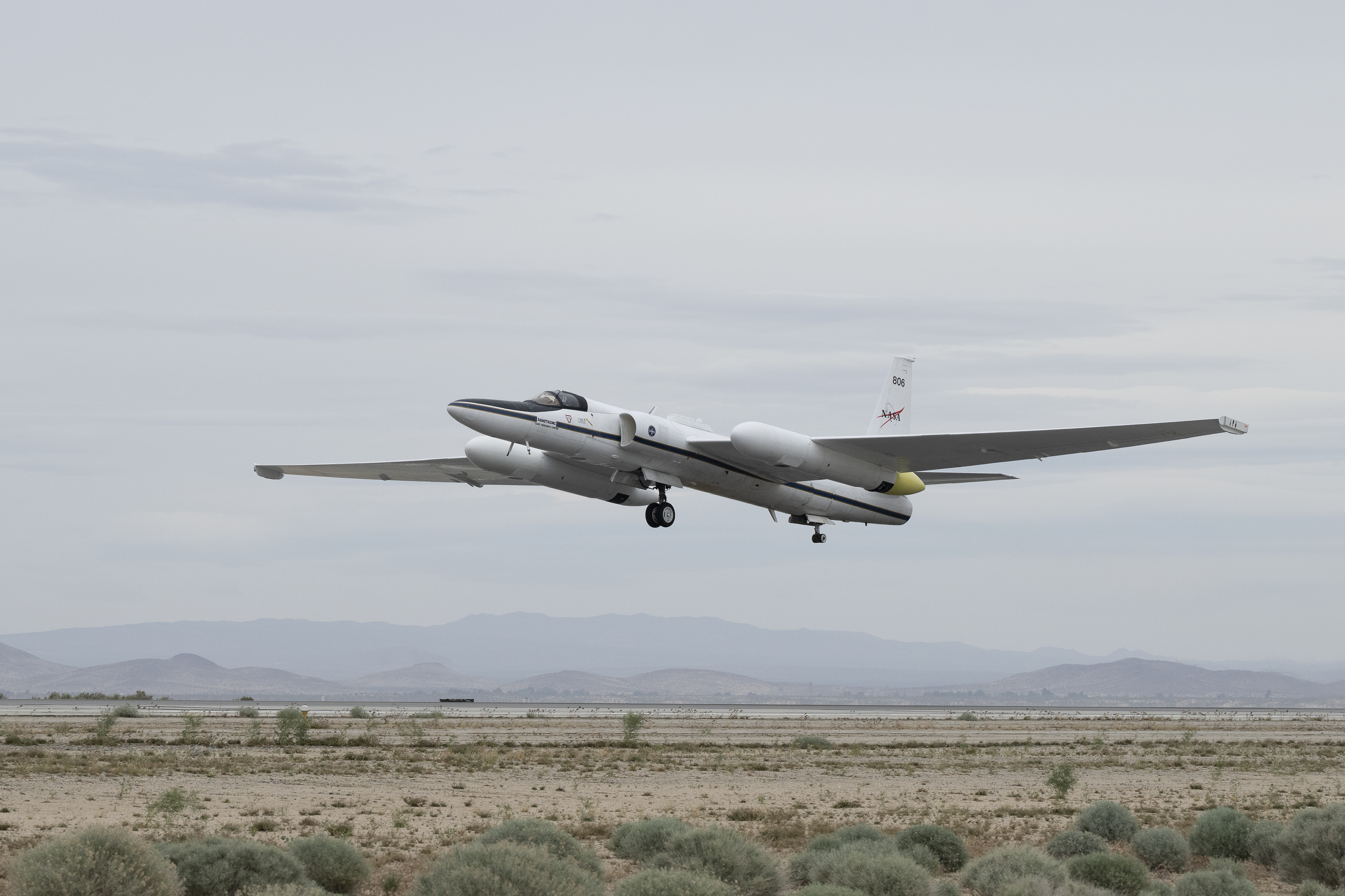
Carrying next-generation sensors, a high-altitude NASA ER-2 aircraft takes off from the agency’s Armstrong Flight Research Center in Edwards, California, on March 31, 2026, to support the GEMx mineral mapping campaign.
NASA/Carla Thomas
Since 2023, GEMx flights have covered more than 386,000 square miles (1 million square kilometers) of American soil, including most of California.
Ground-truthing the sensor data can entail hot field work, scrambling over steep crags to uncover samples for lab analysis. While testing has confirmed the topaz discovery, determining if the Mojave site overlies a porphyry copper deposit will require intensive investigation using ground-penetrating equipment. But the AVIRIS finding shows how advanced NASA airborne sensing can help lead geologists to the metaphorical needle in a haystack, even in heavily explored Southern California.
“People have been prospecting this area for generations,” said Erik Tharalson, a USGS geologist. “But there’s a lot more to discover.”
High flyer
From the beginning, the GEMx mineral mapping campaign has been enabled by one of the highest-flying aircraft in NASA’s fleet: the ER‑2. It deployed on March 31 from NASA’s Armstrong Flight Research Center in Edwards, California, to Colorado Springs Airport in Colorado.
“We deployed to Colorado Springs to maximize flight time for data collection needed in Colorado, Utah, New Mexico, Arizona, and Texas,” said John McGrath, ER‑2 project manager at NASA Armstrong.
By the conclusion of this deployment on June 5, the aircraft had completed 26 flights totaling more than 125 hours. Soaring at about 65,000 feet, the ER-2 can fly at high altitudes that allow it to collect broad‑area, high‑resolution spectral measurements in a single pass, supporting researchers studying mineral composition and surface processes.
In 2025, the aircraft flew 36 science missions, collecting more than 7 billion measurements over 200 flight hours. The data has contributed to the largest airborne surface mineralogy dataset gathered in a single NASA-USGS campaign.
The GEMx survey is led and funded by the USGS Earth Mapping Resources Initiative. Earth MRI is modernizing mapping the nation’s surface and subsurface to find new, critical, and other minerals. It is a partnership effort with 45 state geological surveys, federal agencies, private industry, tribes, universities, and others. The initiative will capitalize on both the technology developed by NASA for spectroscopic imaging, as well as the USGS expertise in analyzing the datasets, conducting field work, and deriving critical mineral information from them.
Rising seas could turn mangroves from carbon-storing climate allies into unexpected carbon emitters. Mangroves are among the most effective natural systems for capturing and storing carbon, but new research suggests that rising sea levels could significantly reduce that benefit and may even cause these coastal forests to release carbon in the future. Made up of [...]
Ancient asteroid impacts may have done more than reshape Earth’s surface. For decades, asteroid impacts have been viewed mainly as agents of destruction. But on the young Earth, they may have done something far more surprising: helped create some of the planet’s first habitable environments. A new study from Southwest Research Institute (SwRI) suggests that [...]

 Login