This is part 2 of a two-part series examining the U.S.’s efforts to begin deep-sea mining in federal waters. Part 2 examines the regulations that would govern the industry. Part 1 explored the process behind proposed lease sales in U.S. federal waters and reactions to those plans. The deep-sea mining industry could launch in the near future in U.S. federal waters. Yet legal experts and former government officials warn that the regulations that would govern this industry are outdated and lack important oversight provisions. In April 2025, the Trump administration signaled its intention to enter the global race to mine the deep sea when it released an executive order calling for the development of the industry. Following the administration’s direction, in April 2026 the U.S. Department of the Interior (DOI) announced its plans to hold a series of seabed lease sales over the course of this year and into early next. The first one is slated for August in American Samoa, with subsequent lease sales planned for the Commonwealth of the Northern Mariana Islands (CNMI) and Alaska. If these go forward, they could mark the first commercial lease processes for deep-sea mining anywhere in the world. Critics say deep-sea mining could cause large-scale and irreversible damage to the marine environment, and some governments in areas slated for leasing have even taken steps to ban deep-sea mining. In 2024, the governor of American Samoa enacted a moratorium on seabed mining from its territorial waters, which extend 3 nautical miles (5.6 kilometers)…This article was originally published on Mongabay
Cities are expanding faster than at any point in human history, and wildlife is adapting in remarkable ways. We often talk about visible changes like animals becoming bolder, shifting their diets, or altering their daily rhythms to avoid people. But there is a deeper transformation happening inside their bodies, one that conservation science has barely begun to address: The reshaping of the gut microbiome. Urban ecosystems expose animals to a completely different set of pressures than their natural habitats. Artificial light, chronic noise, pollution, and human-derived food sources all interact to shape the physiology of wildlife rapidly. These pressures don’t just influence behavior from the outside, they alter the microbial communities that regulate digestion, immunity, stress responses, and even cognition, making key components of how animals evolve and adapt as “pressure cookers,” reducing diversity and decreasing overall health. When the microbiome becomes disrupted, a state known as dysbiosis, animals may become more anxious, more risk-taking, or more susceptible to disease. Urbanization is forcing this rapid adjustment of species not just through habitat loss, but by fundamentally changing their microbiota, and with that, things like foraging patterns and predator avoidance. In other words, urbanization may be shaping wildlife behavior from the inside out. Mule deer in Banff, Alberta. Image by Sharon Hahn Darlin via Wikimedia Commons (CC BY 2.0). Yet conservation strategies rarely consider this internal dimension. We focus on green spaces and habitat restoration, which are essential, but overlook how environmental stressors affect the microbial health of the animals we…This article was originally published on Mongabay
TANGGAMUS, Indonesia — When Sri Atmiatun arrived in the hills of the Batutegi region in southern Sumatra’s Lampung province in 2017, the coffee trees were already there, overgrown and neglected, slowly fading back into scrub. Her uncle had asked her to take over the plot. Sri agreed, trading years of labor on oil palm plantations in the central Sumatran province of Riau. Nearly a decade later, she still walks the same uphill path each morning. Now 45, Sri manages more than 3 hectares (7.4 acres) of land within the 1,400-hectare (3,460-acre) Sumber Makmur social forestry area. Sumber Makmur itself sits on the edge of the more than 80,000-hectare (198,000-acre) Batutegi forest landscape, where some areas are strictly protected while others are managed by communities through agroforestry systems. Under the social forestry program, the land remains state-owned, but local communities like Sri’s are granted the right to manage it for their livelihoods under rules designed to protect the forest and its ecological functions. “I stayed because this land feeds us,” Sri told Mongabay in early March. “If I leave, who will take care of it?” Sri’s story reflects a broader shift. Across the Batutegi landscape, land that was once cleared for coffee is now being restored and managed under Indonesia’s social forestry program. Legal recognition has given farmers access to support and training from the government and private organizations. In return, forest clearing and expansion into protected core areas have been reduced, allowing the forest to remain a safe habitat for…This article was originally published on Mongabay
In Bangladesh, poor oversight of unlawful cross-border trade in hazardous electronic waste continues, turning the country into a net importer of electronic waste. The country has rules to control e-waste. It is also a party to the Basel Convention and has introduced its own laws, like the Hazardous Waste (E-waste) Management Rules (2021). However, enforcement of these frameworks remains weak. Mongabay obtained and reviewed the document outlining Bangladesh’s import and export of e-waste, revealing key details on trade flows and regulatory gaps. The document, by the National Board of Revenue (NBR), shows that 40 companies imported e-waste under HS code 8549 — the international customs code for trading e-waste — at various times between 2022 and 2025, in apparent violation of the Basel Convention, an international treaty to reduce the movements of hazardous waste between nations. The textiles and apparel industry leads at 27%, or about one quarter, of all e-waste importers. No response from importers Mongabay reached out to Unilever Bangladesh Limited, one of the 40 e-waste importing companies and the only one that responded. Shamima Akhter, director of corporate affairs, partnerships & communications of Unilever Bangladesh Limited, said in an email on May 21, “We confirm that we have not imported any e‑waste or restricted items. The product concerned is a load cell, which is a precision measuring instrument, and the correct HS Code for this item is 90318, as declared in our import documentation. Any change to HS Code 8549 during the clearance process was made independently…This article was originally published on Mongabay
From above, an intact forest can look reassuringly complete. A satellite image may show an unbroken canopy, a block of green still standing amid plantations, roads or logged land. For many conservation programs, that view has become the starting point for measurement. If the canopy remains, the forest is often treated as if much of its ecological value remains as well. The forest itself may tell a more complicated story. Birds, insects, frogs and primates divide the day among them. Some call at dawn, others at night. Some occupy narrow frequency bands; others fill the background with a steady rasp. A forest that looks intact can still lose part of this living structure. The canopy may close after logging. Carbon may remain on a balance sheet. The animal community may not return in the same form. Garnet Pitta. Photo by Hanyrol Hanyzan Ahmad Sah A new paper in Global Change Biology, by Zuzana Buřivalová and colleagues, examines that problem through sound. The study describes the Soundscape Baselines Project, an effort to record the acoustic signatures of some of the world’s remaining intact forests before those reference points become harder to find. The idea is straightforward. To know whether a forest has changed, one needs to know what it sounded like before the change. That baseline is not only a technical convenience. It is a guard against a familiar problem in conservation: each generation tends to accept the nature it first encountered as normal. Daniel Pauly called this shifting baseline syndrome…This article was originally published on Mongabay
Deep in Taiwan’s misty mountains, researchers have confirmed the tallest tree in the country: a thousand-year-old fir tree higher than a 20-story building, which they’ve named “the heaven sword of the Da’an River.” Climbers scaled the tree and dropped a measuring tape from the top to the forest floor during the Lunar New Year holiday in January 2023. The tree measured 84.1-meters (276-feet). The findings have been published in Frontiers in Forests and Global Change. A team of ecologists, geologists, remote-sensing specialists, professional climbers and Indigenous people that calls itself the “Taiwan tree seekers” began the search in 2014. “The common characteristics [of the team] are probably that we are all tree lovers and like adventures,” Rebecca Chia-Chun Hsu, lead author from Division of Forest Ecology, Institute of Taiwan Forestry Research, told CNN. ‘The Heaven Sword’, Taiwan’s tallest tree, measures 84.1 meters. Photo courtesy of Steven Pearce. Taiwan is one of the few places on Earth where trees can grow this tall. The island sits where the tropics meet the subtropics, and its mountains host several giant conifer species. The species behind the new record, Taiwania cryptomerioides, is known to the Indigenous Rukai people as “the tree that hits the moon.” Although nearly 60% of Taiwan is covered in forest, loggers cleared much of the island’s old-growth forest between 1912 and 1991. However, its steep slopes were too dangerous to reach, and pockets of ancient forest survived. Still, finding the tallest tree amid the rugged terrain was a task. Taiwan…This article was originally published on Mongabay
COLOMBO — Sri Lanka banned the purchase and use of single-use plastic water bottles in all government institutions effective May 31, under a new government circular that targets reduction of wasteful plastic consumption within the state sector. The move is the latest in a long line of attempts by the island nation to reduce plastic pollution — a crisis that clogs waterways, pollutes beaches, harms marine life, and overwhelms the country’s fragile waste management systems. But environmentalists say the real question is not whether Sri Lanka can announce another ban, but whether it can be enforced. The new directive applies to public institutions and is expected to reduce the routine use of disposable plastic water bottles during government meetings, events, offices and official functions. Authorities are encouraging reusable alternatives and better drinking water infrastructure within public institutions, says Kapila Rajapaksha, the director-general of the Central Environmental Authority (CEA), the state agency mandated to address plastic pollution. Sri Lanka’s plastic problem is growing exponentially. The National Plastic Waste Inventory (NPWI) published in 2024 has estimated the island’s municipal plastic waste generation to be approximately 250,000 metric tons per year. Sri Lanka recycles only about 27,000 metric tons of plastic waste annually, roughly 11% of total plastic waste generated. An estimated 68,000 metric tons, or 27% of plastic waste, remain uncollected and are often burned, buried or illegally dumped. Approximately 101,000 metric tons or 41% of the plastics go unaccounted from the waste management system during collection, transport, sorting and disposal. According…This article was originally published on Mongabay
PORT HUGHES, Australia — Situated midway along the Great Southern Reef that spans Australia’s southern coastline, the waters off Port Hughes typically teem with life. The coastal hamlet northwest of Adelaide plays host to a multitude of coral, bivalve and fish species. But in late March, the largest and longest harmful algal bloom (HAB) in Australian history arrived to Port Hughes, depleting its waters’ rich biodiversity. The bloom had first appeared elsewhere off the state of South Australia’s coast a year earlier, causing eye and skin irritation and respiratory symptoms among beachgoers. Then, along with waves of acrid-smelling sea foam, scores of dead marine animals began washing ashore. In Port Hughes, the HAB’s impacts were most visible below the surface. The town’s wooden jetty had previously been one of the most consistent locations in South Australia to observe temperate species, said Stefan Andrews, co-founder of the Great Southern Reef Foundation, a conservation advocacy group. But by mid-April, when Mongabay joined Andrews on a dive, the site was drab compared with vibrant photographs taken in February and March. Under the jetty, sponges and corals that had previously adorned its pylons in a brilliantly hued mosaic appeared colorless. Apart from a short-headed seahorse (Hippocampus breviceps) — a “sign of hope,” Andrews called it — little life was visible in the murky waters. The reef, he said, had become quieter, lacking the sounds of snapping shrimp and other creatures that once played in the underwater soundtrack. “There’s a sense of loss when you…This article was originally published on Mongabay
JEJU ISLAND, South Korea — In April 2025, I zipped myself up into a thick wetsuit and inched down a steep, rocky ledge toward the gray-blue water encircling Beomseom, a small island off the southern coast of Jeju Island in South Korea. Then I leapt into the chilly sea and wriggled into my scuba gear while floating on the surface. In the water with me was Sanghoon Yoon, an adviser for Paran Ocean Citizen Science Center, a South Korean civil society group that advocates for the protection of the ocean. That day, Yoon was my scuba dive buddy. Yoon and I sank beneath the dangling legs of snorkelers into a watery realm of rocks and kelp. Once in deeper water, I encountered gelatinous stalks of soft coral. The polyps appeared purple, pink, red, and even orange, depending on the light. The islet of Beomseom off South Korea’s Jeju Island hosts colorful gardens of soft coral. Image courtesy of Paran. Sanghoon Hoon, an adviser to the Paran Ocean Citizen Science Center, dives among corals in the waters off Jeju, South Korea. Image courtesy of Paran. The soft corals I saw that day were healthy. But in 2024, soft corals around Beomseom Island and other parts of Jeju experienced what scientists are calling a “slumping” event — and what Yoon describes as “melting” — which saw soft corals losing their shape, drooping, and even dying. The event was widely reported in local media and attributed to marine heat as Jeju waters hovered…This article was originally published on Mongabay
ELEPHANT MARSH, Malawi — At 5:30 am, trader Flora Kumilai is squatting before a heap of smoked catfish at Sorjin Market in southern Malawi’s Elephant Marsh, haggling with sellers over the price. “I found gold in fish,” she chuckles as she fills a third cardboard box. “And Elephant Marsh is the mine.” Kumilai, who has traveled here from Malawi’s commercial capital, Blantyre, will spend a week in the area, visiting other fish markets around the marsh until she has 12 of these boxes, around 900 kilograms (1,990 pounds) of smoked fish. Then she will band together with other traders to hire a truck to transport their goods back to Blantyre, 140 kilometers (87 miles) to the north. But for Kumilai, the final destination for her goods is more than 1,500 km (930 mi) away, at a market in Kasumbalesa on the border between Zambia and the Democratic Republic of Congo. She’s been in business for more than a decade now, mostly trading in produce within Malawi and sometimes importing clothes from Tanzania and South Africa for customers in the city. In October 2024, she changed course, when fellow traders introduced her to the cross-border trade in fish. In Kasumbalesa, most of Kumilai’s customers are from the DRC, she tells Mongabay in Chichewa. “They pay in [U.S.] dollars. When we change it on the black market to Malawi kwacha, it gives us a lot of money. That’s how I’m able to pay for my son’s education [at Chandigarh University in India].”…This article was originally published on Mongabay
As South Africa transitions away from coal-fired electricity, hundreds of former coal mines are turning into abandoned dumping sites for waste and polluted water, which a new report warns will continue to contaminate surrounding land and waterways for decades. Nor is the South African government taking action to force mine owners to clean them up, environmentalists told Mongabay. South African law requires mining companies to set aside money to clean up and restore the land after mining ends – either in trusts or through bank or insurance guarantees. But a report by the Centre for Environmental Rights found that none of the 412 coal mines that closed between 2006 and 2023 had enough money set aside to pay for the full cost of rehabilitation. The full extent of the problem is unknown as the government has failed to keep any records of mines that closed in 2008, 2010, 2012, 2013, and 2021, the report said. Mining companies must clean up and rehabilitate mines, pay for the damage, and remain responsible until the government officially signs off on the closure, according to the regulations. But most mines do not keep enough money aside to cover even a fraction of the rehabilitation costs, according to the report, titled “No More Ghost Towns : Lessons From Mpumalanga’s Mine Closure Crisis” and released May 22 in Johannesburg. With more than 100 coal mines and most of the country’s aging coal-fired power stations, the Mpumalanga region is the center of South Africa’s fossil fuel-based power…This article was originally published on Mongabay
BANGKOK — More than 600 residents of Chiang Mai and Chiang Rai provinces embarked May 31 on a roughly 68-kilometer, six-day ‘peace walk’ to demand the Thai government take action on the river pollution crisis that has seen Thai rivers polluted with heavy metals. The ensemble of affected residents, civil society groups, monks and students marched from Tha Ton subdistrict in Chiang Mai to the city of Chiang Rai in northern Thailand, reaching their destination on June 5, World Environment Day. For more than a year, Thailand’s Pollution Control Department has reported dangerous levels of arsenic, mercury, cadmium and other heavy metals in rivers across northern Thailand, with mining operations across eastern Myanmar suspected to be responsible for the pollution. “We are walking because our rivers are slowly dying,” Pianporn Deetes, executive director of the Rivers and Rights Foundation, which helped to organize the peace walk, told Mongabay by phone. “Toxic contamination from unregulated mining upstream is already affecting water, fish, food, livelihoods, and public health. We do not want to wait until more people become sick. This is an emergency.” Pianporn said the walk (42 miles) was about taking collective action to share information, document impacts and build public pressure in a bid to force the government to address the issue, which Pianporn said has, so far, been lacking. “Monitoring has improved, but action has not matched the scale of the crisis,” she said. “We need urgent diplomatic engagement with neighboring countries, stronger health monitoring, transparency, and action to…This article was originally published on Mongabay
Global oil giant Shell continued operating a compromised pipeline in Nigeria’s Niger Delta despite knowing it posed a pollution risk in the surrounding coastal wetland environment, newly disclosed internal company communications reveal. The emails and memos, reviewed by Mongabay, show senior leadership knew of the poor conditions of the 97-kilometer (60-mile) Nembe Creek Trunk Line as early as 2008. Despite concerns it was operating outside technical integrity standards and proposals to shut it down, a top executive decided to keep pumping oil through the line. Carrying 150,000 barrels of oil per day to the export terminal at Bonny Island Rivers state, the Nembe Creek Trunk Line is a critical oil artery in Nigeria. Throughout the years, theft from the pipeline using illegal connections caused spills into the vast mangrove ecosystem of true (Rhizophora sp.) and flowering black (Avicennia sp.) tree species. An internal 2013 Shell document coded such tampered lines as “red,” requiring either their immediate shutdown or immediate action to remove all illegal connections. Locals from the nearby riverine Bille community said the oil spills killed about 2,000 hectares (4,900 acres) of mangrove swamps around the village while impacting an area of 13,200 hectares (32,600 acres). The contaminated waterways and degraded ecosystem, they told Mongabay, killed fish and other aquatic life. Satellite imagery surrounding the village shows massive degradation of the mangroves. “The aquatic life is gone. Our people can no longer go to the river and catch reasonable fish — they can’t even find the fish in the…This article was originally published on Mongabay
Leoncia Ramos has lived her 65 years in the lush Dominican Republic town of La Piñita, but now says she is fearful for her health and wants to leave. She’s among 450 families asking the government and the company behind the Pueblo Viejo gold mine to be relocated because of concerns of pollution from the nearby mine. They allege the site, controlled by Canadian giant Barrick Mining Corp., is harming their health and the environment, and fear that if a tailings dam about a kilometer away were to collapse, it would be disastrous. Ramos’s community has spent 15 years fighting to have its concerns addressed and now says Canada, where Barrick Mining is headquartered, could play a role. In 2019, the Canadian government created an office of an ombudsperson to handle complaints from communities like Ramos’s. But the government has left the role vacant for the past year, and its work has seemingly come to a standstill. Canada is home to about half of the world’s publicly traded mining and mineral exploration companies, with operations both in Canada and overseas, including some of the world’s largest miners, like Barrick Mining. The government created the office of the Canadian Ombudsperson for Responsible Enterprise (CORE) in 2019 to address human rights complaints about Canadian companies’ operations overseas. But the office has now been without an ombudsperson since May 2025, and advocates say its work has stalled at a critical moment, as demand for transition minerals and a changing geopolitical climate are driving…This article was originally published on Mongabay
NASA’s Artemis II Moon Mission Research Continues on Earth
Artemis II astronaut Victor Glover walks on a treadmill while in a space suit harnessed to NASA’s Active Response Gravity Offload System at NASA’s Johnson Space Center. Glover is simulating a walk on a planetary surface while in a suit that has been offloaded to lunar gravity. Artemis II astronauts completed this and other suited tasks before their mission launched and within a few days of landing, giving researchers a chance to assess how quickly upon landing crews’ bodies adapt to a different gravity. Results will help scientists better understand how soon after landing crews can complete mission-critical tasks on the surface of the Moon or Mars.
NASA/Robert Markowitz
Since NASA’s Artemis II crew members safely splashed down in the Pacific Ocean on April 10 after their record-setting mission around the Moon, science teams have been busy collecting more data and combing through observations collected on the test flight. Results from these science investigations will help support safe human exploration of deep space and provide a blueprint for how future missions will conduct science on the lunar surface as NASA builds a Moon Base and develops an enduring human presence there.
Postflight crew health, performance data
In the hours, days, and weeks after landing, the Artemis II crew members, NASA astronauts Reid Wiseman, Victor Glover, Christina Koch, and CSA (Canadian Space Agency) astronaut Jeremy Hansen, contributed critical data to help the agency understand how the human body reacts to spaceflight. Collecting this data as soon as possible after landing was important to understand how the body adapts from microgravity to Earth’s gravity. The data will inform NASA’s understanding of how quickly crews can complete mission-critical tasks after landing on a planetary surface like the Moon or Mars, where there won’t be landing support personnel to assist.
Within a day of splashdown, researchers collected a suite of data for the Artemis II Spaceflight Standard Measures study, which is part of a larger effort across the astronaut corps to gather a baseline set of health measurements on blood pressure, heart rate, eye health, and motor control. Crew members also completed a mini obstacle course, which included lying down, standing up, unfurling a rope ladder, ladder climbing, and more, to assess how their bodies were adapting to Earth’s gravity.
Once the crew returned to NASA’s Johnson Space Center in Houston, researchers guided them through further medical check-ups and tests of motor control. Over the next several days, the crew completed obstacle courses wearing spacesuits offloaded to lunar gravity, which is roughly one-sixth the force of Earth’s gravity. Researchers are now analyzing this data to gain insight into how crews may perform as they adapt to the gravity of a planetary surface.
As part of the Immune Biomarkers study, researchers are comparing blood and saliva samples collected after the Artemis II splashdown with samples collected preflight and during the mission. Among other topics, the study investigates whether and how dormant viruses reawaken in astronauts’ bodies while in space.
Some crew members completed postflight cognition tests and a simulated manual spacecraft docking task to assess motor control for the ARCHeR (Artemis Research for Crew Health & Readiness) study. This, combined with data collected through a wrist-worn device while crew members were in space, is used to understand the effect of space hazards on well-being and performance.
Initial data collections for Artemis II health studies concluded 45 days after splashdown. However, medical teams will continually monitor astronaut health throughout the Artemis II crew members’ lifetimes.
Once this data is processed and anonymized, information will be available for scientists to study the effects of spaceflight via a request to NASA’s Life Sciences Data Archive. The results from this work could lead to new technologies and studies that help predict the adaptability of crews on future missions to the Moon and Mars.
Analyzing astronaut-derived organ chips flown around Moon
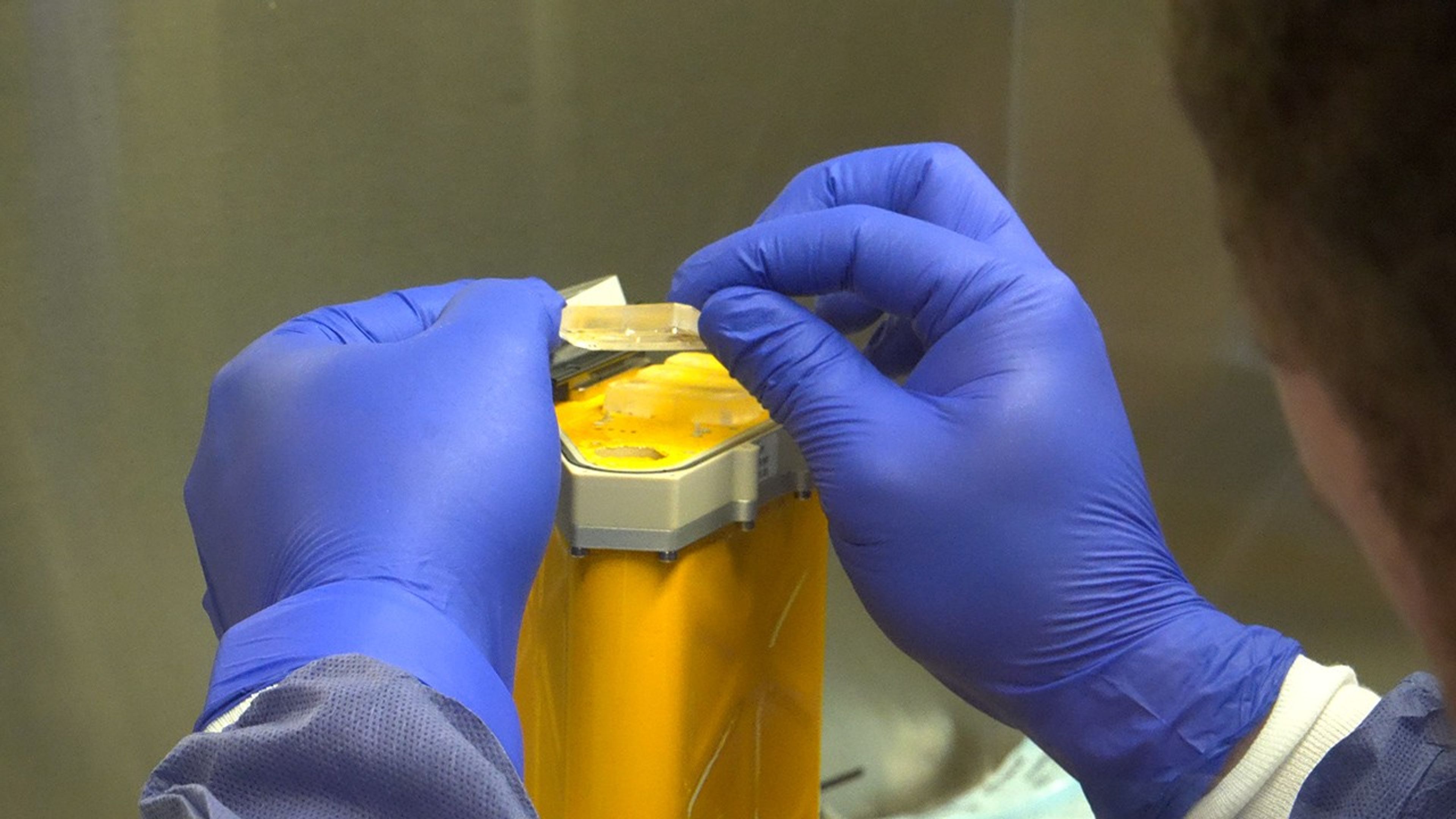
A scientist handles AVATAR organ chips following their journey around the Moon aboard Orion. The chips contain cells from each astronaut and are being prepared for detailed analysis.
NASA
Organ chips from NASA’s AVATAR (A Virtual Astronaut Tissue Analog Response) investigation are being analyzed at chip developer Emulate’s laboratory in Boston. The organ chips included bone marrow cells from each Artemis II astronaut. They flew around the Moon with the astronauts, and now researchers are studying these organ chips to determine how deep space radiation and microgravity affect human health at the molecular level.
Scientists are comparing the chips flown aboard the spacecraft to ground controls and crew blood samples using advanced techniques, including single-cell RNA sequencing. The analysis will characterize how organ chips model individual responses to spaceflight, which is data that could allow NASA to send future astronauts’ AVATAR chips ahead on missions to develop personalized medical kits. The researchers plan to share early findings at scientific conferences while full analysis continues.
Lunar imagery, audio for data release
In this April 3, 2026, image, the Artemis II lunar science team is shown working in the Science Evaluation Room in the Mission Control Center at NASA’s Johnson Space Center in Houston. The team is putting together a plan of science observations for the Artemis II crew, which was headed toward the Moon aboard Orion. As they passed the Moon at closest approach on April 6, the crew applied the geology skills they learned in the classroom and in Moon-like environments on Earth as they photographed and described nuances of geologic features such as impact craters, ancient lava flows, and surface cracks and ridges. The crew noted differences in color, brightness, and texture — details that provide clues to surface composition and history.
NASA/Bill Stafford
On April 6, the Artemis II crew members studied features on and around the Moon for nearly seven hours during Orion’s closest approach to the lunar surface. Their work was guided by a minute-by-minute observation plan developed by the Artemis II lunar science team.
Scientists are reviewing the data collected from the mission, which includes images, video, and audio files, to release a report of their initial data interpretations later this year. The report will cover observations of impact flashes, variations in color on the lunar surface, and the shape and texture of faults and ridges. The team also will publish a report on how Artemis II lunar science observations were planned, organized, and executed for the benefit of future Artemis missions.
NASA will publish more than 100 science-related audio recordings with transcripts, as well as approximately 11,500 Earth and Moon image and video files from the mission science campaign, with accompanying data. While many of these images already are public, these records will be available through NASA’s Planetary Data System, a public archive of data from all of NASA’s planetary missions. To get the data ready, the team is converting files into standard formats that anyone can easily open and add information to make the data searchable in NASA’s archive for generations to come.
For more information on NASA’s Artemis II science efforts, visit:
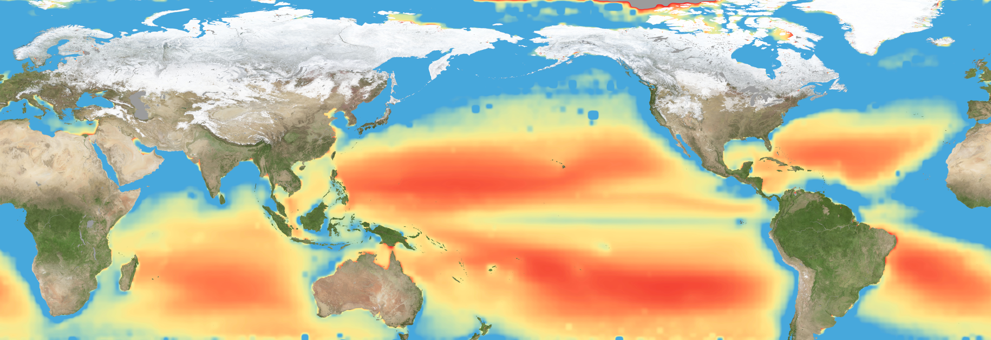
Warming waters decrease upwelling and lead to stress on marine microorganisms due to limited availability of vital nutrients. Red indicates the regions of highest nutrient-related stress.
Kel Elkins/NASA’s Scientific Visualization Studio
Editor’s note: This article was updated on June 5.
A new study combining NASA satellite observations, ocean surveys, and genetic testing on marine microorganisms found evidence that warming ocean waters may be limiting nutrient availability across much of the global ocean. The researchers report that this nutrient stress affects microscopic marine organisms and could influence marine ecosystems over time.
The research, published June 5 in Science Advances, tracked the condition of phytoplankton, which form the base of ocean food webs. Rather than measuring nutrients like nitrogen, iron, and phosphorus directly, the researchers inferred stress by tracking subtle shifts in the ratio of carbon to chlorophyll in phytoplankton observed from space. When the amount of chlorophyll decreases relative to carbon as seen in satellite data, it’s an indication that the plankton are stressed.
“As our ocean continues to change, the ability to observe and track ocean conditions through sustained, high quality remote sensing observations has never been more important,” said Laura Lorenzoni, Program Scientist for NASA’s Ocean Biology and Biogeochemistry Program at NASA Headquarters in Washington. “This is fundamental, as plankton communities are the base of the marine food web on which important economic activities rely.”
The research team combined two decades of data from NASA’s Aqua satellite’s Moderate Resolution Imaging Spectroradiometer (MODIS) sensor with plankton samples collected on research cruises around the world. The approach linked large-scale satellite observations with genetic markers in Prochlorococcus, a tiny but abundant marine microbe that shows signs of nutrient stress in its DNA. The result is a global map revealing where phytoplankton are thriving and where they’re struggling.
Ocean chlorophyll, as observed with NASA's Moderate Resolution Imaging Spectroradiometer (MODIS) instrument between January 2010 through May 2016.
Marit Jentoft-Nilsen/NASA's Goddard Space Flight Center
The strongest indications of nutrient stress on plankton appeared in the subtropical gyres, which are vast, relatively calm regions of the Atlantic, Pacific, and Indian oceans. In these areas, a layer of warm surface water stifles the flow of colder water from deeper in the ocean.
“When the surface of the ocean warms, it generates this very stable situation where a layer of low-density water sits on top of higher-density cold water,” said study coauthor Adam Martiny, an oceanographer at the University of California, Irvine. “You’ve probably experienced that if you’ve ever been to a lake in the summertime—it’s super warm right on the surface, and very cold deeper down when you stick your legs in.”
This layering blocks the upward flow of nutrient-rich water, limiting the availability of ocean surface nutrients that are crucial for plankton. In the South Pacific, one of the most nutrient-poor regions, a layer of warm surface water contributed to nitrogen and iron shortages, producing the most severe nutrient-related stress that the team discovered.
But the researchers were surprised to find that parts of the North Atlantic experience less nutrient stress than expected. Although there was evidence of a lack of phosphorus, the impact on microorganisms was comparatively mild.
That difference may reflect the biology of the organisms themselves. Phytoplankton can partially compensate for phosphorus shortages by recycling phosphorus more efficiently or replacing phosphorus-rich molecules inside their cells. Nitrogen shortages are harder to overcome because nitrogen is crucial for the proteins and cellular machinery required for photosynthesis and nutrient uptake.
The study revealed that nutrient stress is strongly correlated with seasons and major weather cycles such as El Niño and the Pacific Decadal Oscillation, which lead to warming waters in the Pacific Ocean. During La Niña events, which cool water over a large part of the Pacific, stronger upwelling brought more nutrients to surface waters and reduced stress in some regions. Superimposed on those multi-year cycles, however, was a longer-term trend.
From 2002 through 2021, average sea-surface temperatures increased across nearly 90% of the ocean area examined in the study. Over the same period, nutrient stress generally intensified, consistent with previous hypothesis that warming oceans may become increasingly stratified and less able to replenish surface nutrients.
In many nutrient-poor regions of the Southern Hemisphere, however, the researchers found evidence that nutrient stress had not increased as much as expected despite significant warming. They suspect that microbes capable of capturing nitrogen from the air may partially offset the effects of reduced nutrient mixing.
That finding hints that marine ecosystems may possess more resilience to warming climates than some models predict. It also underscores the complexity of forecasting how ocean biology will respond to continued warming.
“We have two really powerful tools,” said study coauthor Michael Behrenfeld, a biochemist with Oregon State University in Corvallis, Oregon. The tools include satellite observations and cellular studies. “Both produce big data sets, but they are kind of opposites. We have very detailed data about microscopic phytoplankton … and then we have global coverage with satellites.”
By combining satellites that monitor the entire ocean with genetic clues carried inside microscopic plankton, the researchers say they are gaining a new way to track biological responses to changing environmental conditions near real time.
More than a decade ago, conservationists began working to preserve a unique population of desert pampas cats that has adapted to the mangroves of Peru’s northern coast. This small, isolated population roams the San Pedro de Vice dry mangroves, a Ramsar Site and South America’s southernmost mangrove ecosystem. “This is a very unique population, because as far as we know, [it] is the only Pampas cat population that lives in a mangrove [habitat],” Alvaro Garcia, co-coordinator of the Pampas Cat Working Group and the Peruvian Desert Cat Project, told Mongabay in an email. The desert pampas cat (Leopardus garleppi), distinctive for its broad face, ranges along a relatively thin band snaking southward from Colombia through Peru and Bolivia, to northern Chile and Argentina. The species is acclimated to dry conditions, so inhabits deserts, grasslands and dry forests, and isn’t found living in mangroves anywhere else aside from this region of Peru. Dry mangrove forests, also called scrub or dwarf mangrove forests, grow in highly saline soils in upper intertidal zones, so lack regular daily flushing by ocean tides. At first, it was thought the dry mangrove-acclimated cats were faring well: “[I]n the mangrove [habitat], we put cameras out for a week, and we got tons of photos,” whereas in other parts of the felid’s range, conservationists barely capture one desert pampas cat image per month, said Cindy Hurtado, co-coordinator of the Pampas Cat Working Group and the Peruvian Desert Cat Project. Based on the photos, the research team assumed the…This article was originally published on Mongabay
SARLAHI, Nepal — Dhruba Prasai, a farmer from Sarlahi district in Nepal’s southern plains, says he’s exhausted from lack of sleep. Every year, nilgai antelopes, wild boars, deer and Asian elephants raid his fields, and if left unguarded at night, they not only feed on standing crops, but also stored harvest. “There is a forest to the west, and our fields are right next to it,” Prasai tells Mongabay. “The nilgai eat the maize, and the deer can’t even stand the sight of wheat and oat grass, they eat it all. If people stay up at night to guard the fields, they run away; otherwise, they come and destroy everything.” Farmers such as Prasai across Madhesh province, considered the country’s breadbasket because of its fertile land, are struggling with growing crop losses from wildlife, but complex procedures and policy gaps make access to relief, which is already limited, difficult. From mid-July 2024 to mid-July 2025, 14,821 cases of ‘human wildlife conflict’ were reported in Madhesh, according to government figures. A total of 134 people and 457 animals lost their lives. Last year, a wild boar ate three tand (storage racks) of maize stored in Prasai’s house. Although forest authorities told him to get a recommendation letter from the local municipal ward office to apply for relief, he didn’t do it. “I haven’t done it; we simply don’t have the time,” he says. Even those who did fill out the forms around the same time have yet to receive relief, he…This article was originally published on Mongabay
In April this year, two Bryde’s whales washed-up dead-on Dyer Island, a small nature reserve located a few kilometers off the coast of Gansbaai in South Africa’s Western Cape province. Both whales carried severe injuries; their vertebrae had been shattered. “It was very clear that it was [vessel] strikes, because both those whales were snapped in half, and you can also see the propeller marks,” Loraine Shuttleworth, head of research at the Dyer Island Conservation Trust, told Mongabay. Two whale strandings linked to ship strikes in one month alone is an unusually high number, Shuttleworth said. A new risk assessment has linked the increase in risk of ships striking whales to the rerouting of maritime traffic around South African coast. Due to the Houthi rebels attacks on ships traversing the Red Sea, which started in 2023, and the more recent fallout from the blockade of the Strait of Hormuz, many cargo companies have rerouted their vessels around the Cape of Good Hope. With greater shipping traffic comes a growing threat to marine species inhabiting the region: collisions with large, fast-moving vessels. Between December 2023 and December 2024, the number of large vessels traveling through South African waters at average speeds above 15 knots (28 kilometers per hour) has quadrupled, satellite data show. The scale of the increased maritime traffic struck scientist Els Vermeulen from the University of Pretoria’s Mammal Research Institute Whale Unit, on a flight into Cape Town in 2025. “It was a beautiful day, and there were just…This article was originally published on Mongabay

 Login